Deirdre Giesen & Joep Burger Q-Conference, June 2-5 2014, Vienna
Current situation
of the work
Prof. dr. ir. Joep Crompvoets
Dr. Serene Ho
Members of WG-NIA
KU Leuven
Public Governance Institute
New York, 1 August 2017
Public Governance Institute
Overview
1. Introduction
2. Framework development
3. Framework application
4. Key examples
5. Principles & Guidelines
6. Lessons learnt
Public Governance Institute
1. Introduction - Consultancy
“To develop a framework and guidelines in support of
national institutional arrangements in geospatial
information management for Member States”
Supporting the Working Group on National Institutional
Arrangements (WG-NIA)
Execution: February – June 2017
Regular meetings with UN-GGIM Secretariat and WG-NIA
Public Governance Institute
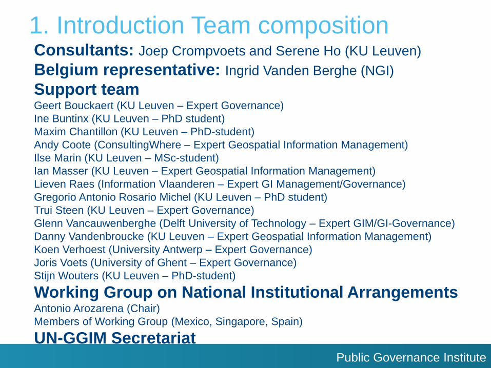
1. Introduction Team composition Consultants: Joep Crompvoets and Serene Ho (KU Leuven)
Belgium representative: Ingrid Vanden Berghe (NGI)
Support team Geert Bouckaert (KU Leuven – Expert Governance)
Ine Buntinx (KU Leuven – PhD student)
Maxim Chantillon (KU Leuven – PhD-student)
Andy Coote (ConsultingWhere – Expert Geospatial Information Management)
Ilse Marin (KU Leuven – MSc-student)
Ian Masser (KU Leuven – Expert Geospatial Information Management)
Lieven Raes (Information Vlaanderen – Expert GI Management/Governance)
Gregorio Antonio Rosario Michel (KU Leuven – PhD student)
Trui Steen (KU Leuven – Expert Governance)
Glenn Vancauwenberghe (Delft University of Technology – Expert GIM/GI-Governance)
Danny Vandenbroucke (KU Leuven – Expert Geospatial Information Management)
Koen Verhoest (University Antwerp – Expert Governance)
Joris Voets (University of Ghent – Expert Governance)
Stijn Wouters (KU Leuven – PhD-student)
Working Group on National Institutional Arrangements Antonio Arozarena (Chair)
Members of Working Group (Mexico, Singapore, Spain)
UN-GGIM Secretariat
Public Governance Institute
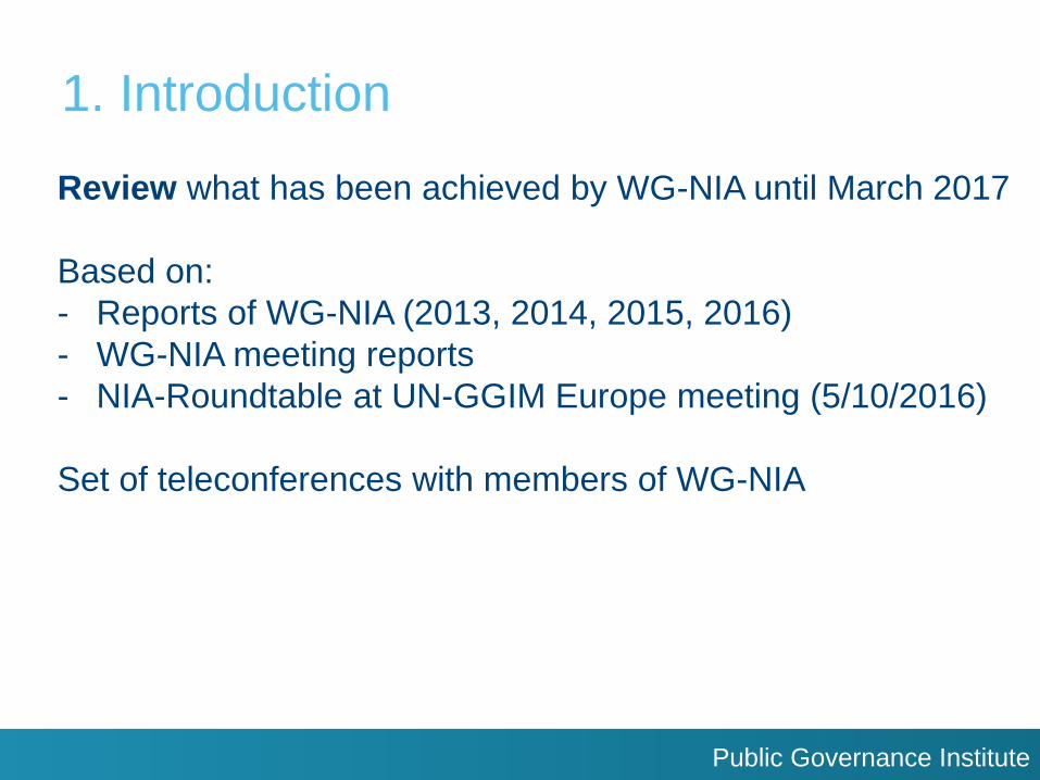
1. Introduction
Review what has been achieved by WG-NIA until March 2017
Based on:
- Reports of WG-NIA (2013, 2014, 2015, 2016)
- WG-NIA meeting reports
- NIA-Roundtable at UN-GGIM Europe meeting (5/10/2016)
Set of teleconferences with members of WG-NIA
Public Governance Institute
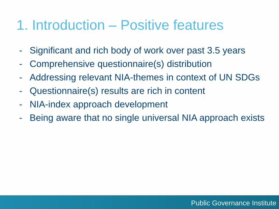
1. Introduction – Positive features
- Significant and rich body of work over past 3.5 years
- Comprehensive questionnaire(s) distribution
- Addressing relevant NIA-themes in context of UN SDGs
- Questionnaire(s) results are rich in content
- NIA-index approach development
- Being aware that no single universal NIA approach exists
Public Governance Institute
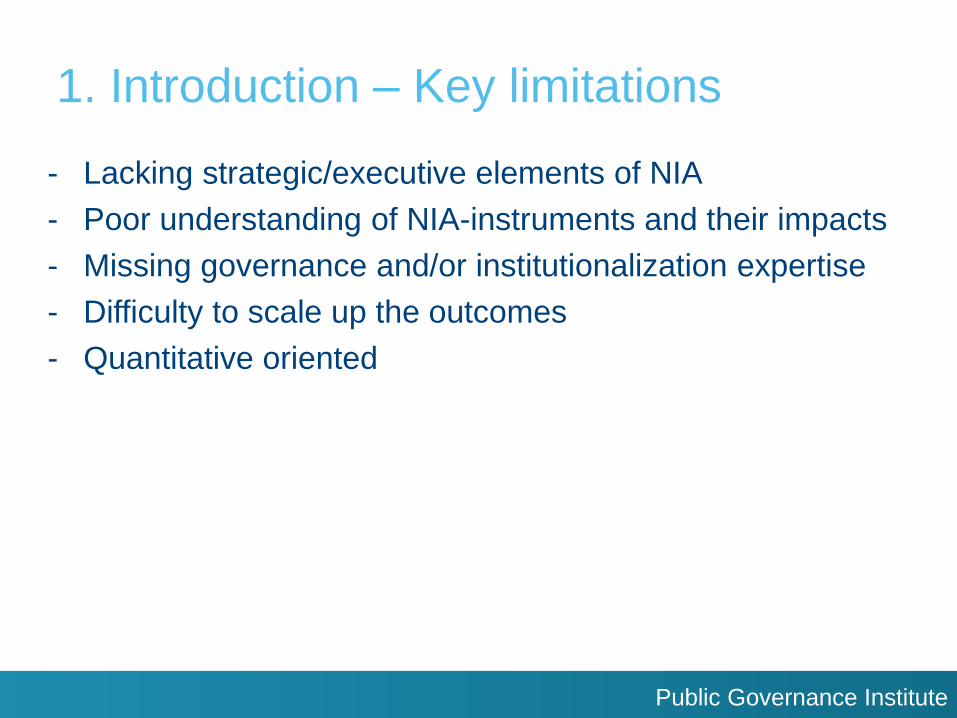
1. Introduction – Key limitations
- Lacking strategic/executive elements of NIA
- Poor understanding of NIA-instruments and their impacts
- Missing governance and/or institutionalization expertise
- Difficulty to scale up the outcomes
- Quantitative oriented
Public Governance Institute
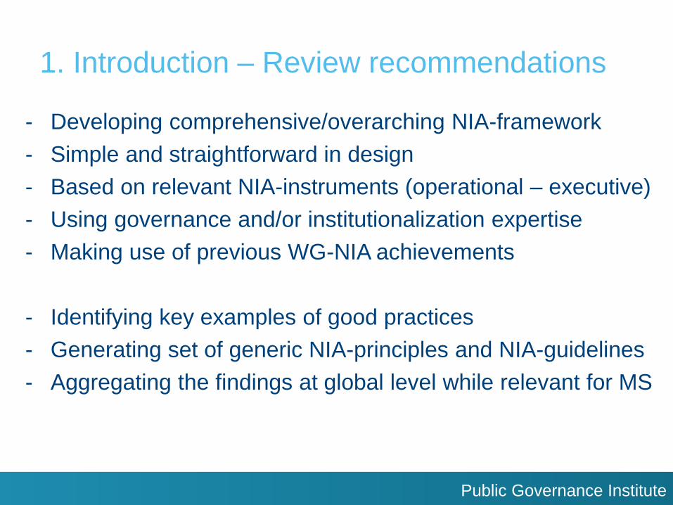
1. Introduction – Review recommendations
- Developing comprehensive/overarching NIA-framework
- Simple and straightforward in design
- Based on relevant NIA-instruments (operational – executive)
- Using governance and/or institutionalization expertise
- Making use of previous WG-NIA achievements
- Identifying key examples of good practices
- Generating set of generic NIA-principles and NIA-guidelines
- Aggregating the findings at global level while relevant for MS
Public Governance Institute
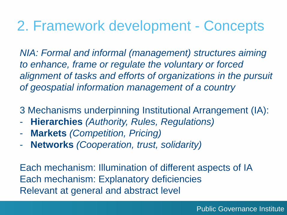
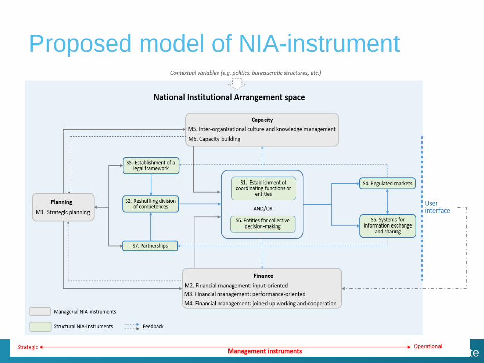
2. Framework development - Concepts
NIA: Formal and informal (management) structures aiming
to enhance, frame or regulate the voluntary or forced
alignment of tasks and efforts of organizations in the pursuit
of geospatial information management of a country
3 Mechanisms underpinning Institutional Arrangement (IA):
- Hierarchies (Authority, Rules, Regulations)
- Markets (Competition, Pricing)
- Networks (Cooperation, trust, solidarity)
Each mechanism: Illumination of different aspects of IA
Each mechanism: Explanatory deficiencies
Relevant at general and abstract level
Public Governance Institute
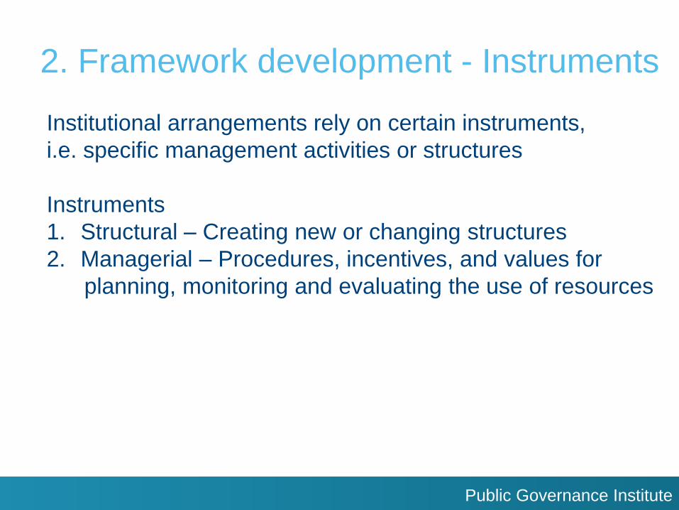
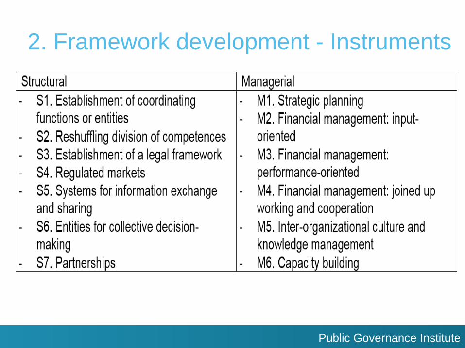
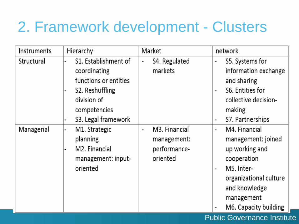
2. Framework development - Instruments
Institutional arrangements rely on certain instruments,
i.e. specific management activities or structures
Instruments
1. Structural – Creating new or changing structures
2. Managerial – Procedures, incentives, and values for
planning, monitoring and evaluating the use of resources
Public Governance Institute
2. Framework development - Instruments
Public Governance Institute
2. Framework development - Clusters
Public Governance Institute
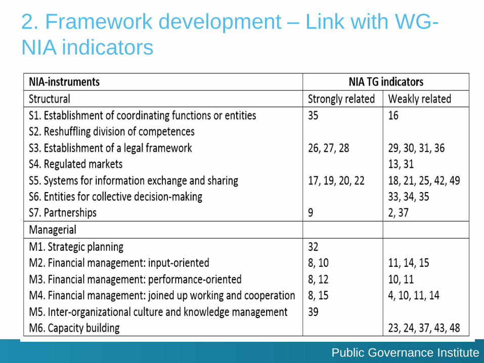
2. Framework development – Link with WG-
NIA indicators
Public Governance Institute
3. Framework application Application of the overarching NIA-instruments framework
Examples of good practices of each NIA-instruments
Subjectivity of good practices -> Consultancy team + WG-NIA
- Review of existing key source materials/documents
(WG-NIA deliverables, UN-GGIM Knowledge Base, etc.)
- Provision of good practices by members of WG-NIA
Minimum of three good practices for each NIA-instrument
Set of selection criteria (Relevance, Information availability,
Currency, Geographical representation)
Good practices: Not necessarily transferable to another MS
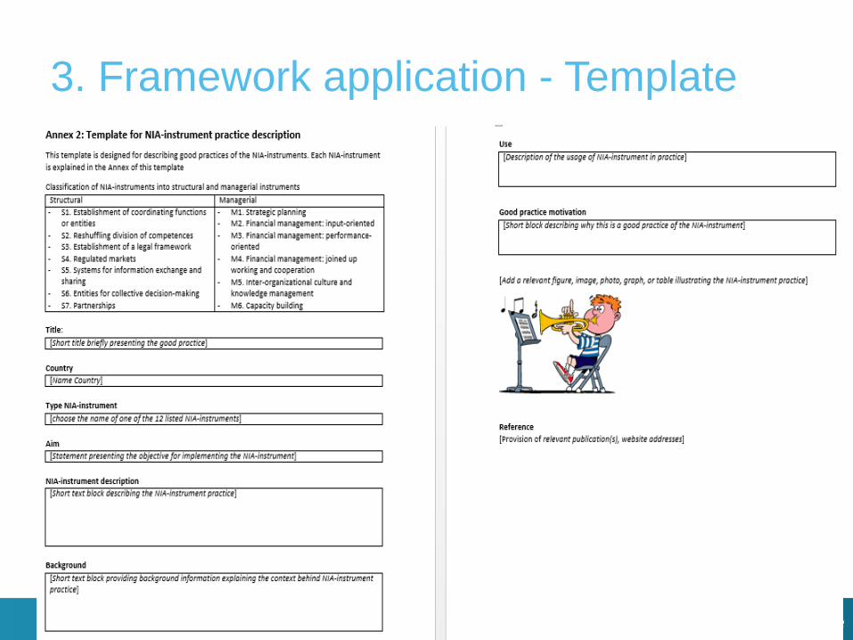
Application of a standard template to describe good practices
Applied in UN-GGIM five regions
Public Governance Institute
3. Framework application - Template
Public Governance Institute
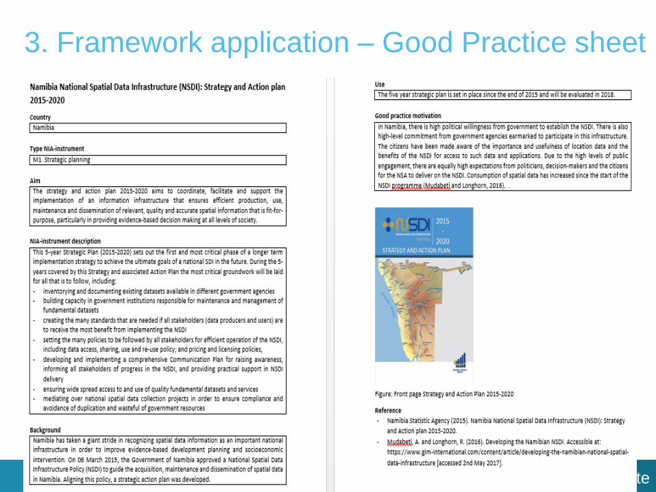
3. Framework application – Good Practice sheet
Public Governance Institute
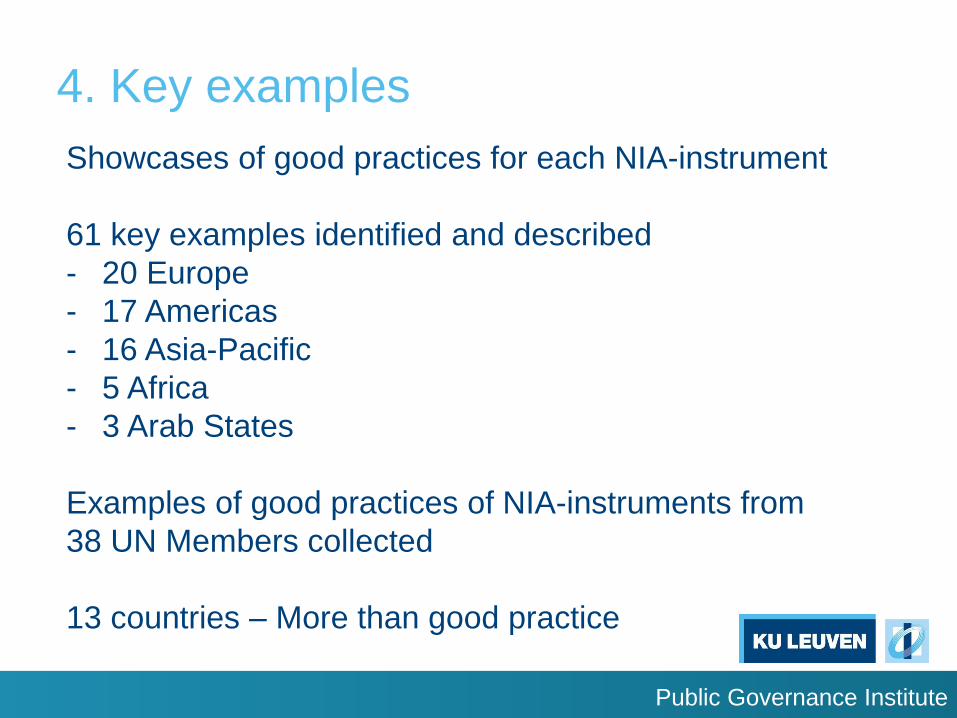
4. Key examples
Showcases of good practices for each NIA-instrument
61 key examples identified and described
- 20 Europe
- 17 Americas
- 16 Asia-Pacific
- 5 Africa
- 3 Arab States
Examples of good practices of NIA-instruments from
38 UN Members collected
13 countries – More than good practice
Public Governance Institute
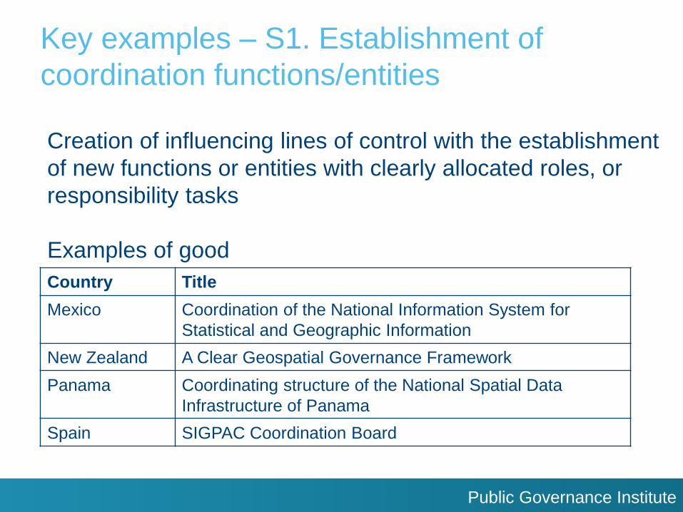
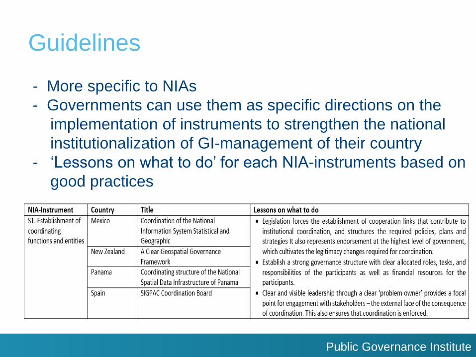
Key examples – S1. Establishment of
coordination functions/entities
Creation of influencing lines of control with the establishment
of new functions or entities with clearly allocated roles, or
responsibility tasks
Examples of good
Country Title
Mexico Coordination of the National Information System for
Statistical and Geographic Information
New Zealand A Clear Geospatial Governance Framework
Panama Coordinating structure of the National Spatial Data
Infrastructure of Panama
Spain SIGPAC Coordination Board
Public Governance Institute
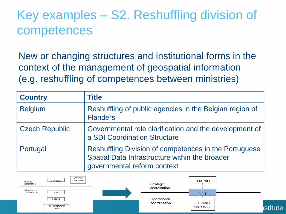
Key examples – S2. Reshuffling division of
competences
New or changing structures and institutional forms in the
context of the management of geospatial information
(e.g. reshuffling of competences between ministries)
Country Title
Belgium Reshuffling of public agencies in the Belgian region of
Flanders
Czech Republic Governmental role clarification and the development of
a SDI Coordination Structure
Portugal Reshuffling Division of competences in the Portuguese
Spatial Data Infrastructure within the broader
governmental reform context
Public Governance Institute
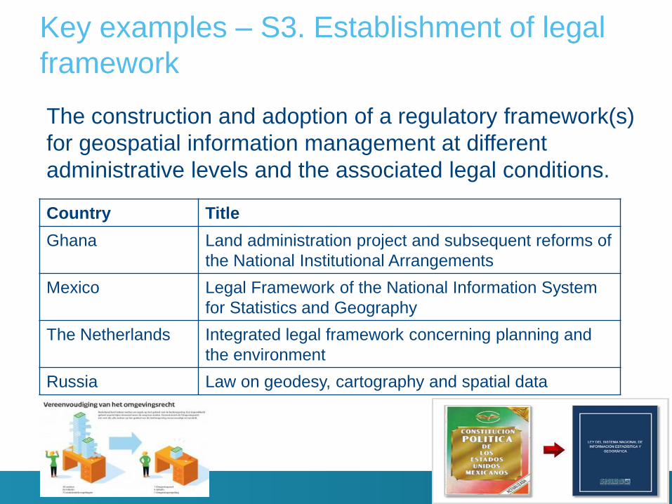
Key examples – S3. Establishment of legal
framework
The construction and adoption of a regulatory framework(s)
for geospatial information management at different
administrative levels and the associated legal conditions.
Country Title
Ghana Land administration project and subsequent reforms of
the National Institutional Arrangements
Mexico Legal Framework of the National Information System
for Statistics and Geography
The Netherlands Integrated legal framework concerning planning and
the environment
Russia Law on geodesy, cartography and spatial data
Public Governance Institute
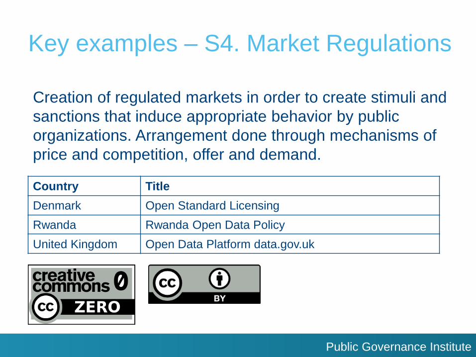
Key examples – S4. Market Regulations
Creation of regulated markets in order to create stimuli and
sanctions that induce appropriate behavior by public
organizations. Arrangement done through mechanisms of
price and competition, offer and demand.
Country Title
Denmark Open Standard Licensing
Rwanda Rwanda Open Data Policy
United Kingdom Open Data Platform data.gov.uk
Public Governance Institute
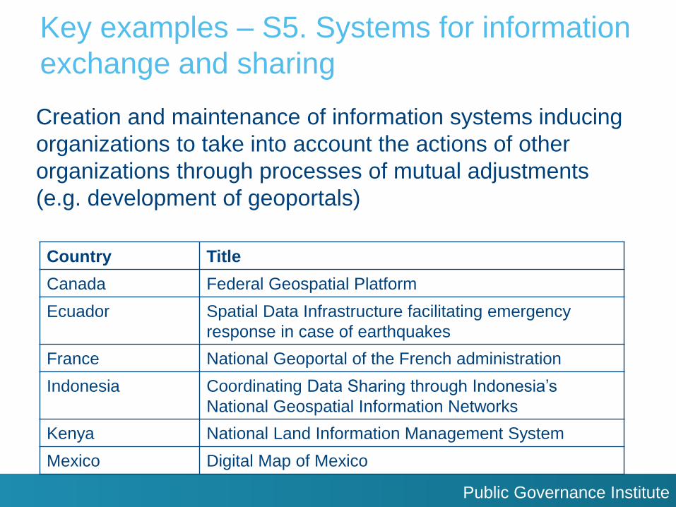
Key examples – S5. Systems for information
exchange and sharing
Creation and maintenance of information systems inducing
organizations to take into account the actions of other
organizations through processes of mutual adjustments
(e.g. development of geoportals)
Country Title
Canada Federal Geospatial Platform
Ecuador Spatial Data Infrastructure facilitating emergency
response in case of earthquakes
France National Geoportal of the French administration
Indonesia Coordinating Data Sharing through Indonesia’s
National Geospatial Information Networks
Kenya National Land Information Management System
Mexico Digital Map of Mexico

Public Governance Institute
Key examples – S5. Systems for information
exchange and sharing
Country Title
Morocco Development of governmental geoportals
New Zealand LINZ Data Service
Republic of Korea Integrated Approach towards Data Sharing through
NIIS
Rwanda SpIDeRR: Spatial Information and Data Portal for
Disaster Risk Reduction
Singapore Sharing Data, Delivering Services and Building
Communities in GeoPlatforms
Spain Cadastral Electronic Site (SEC)
Public Governance Institute
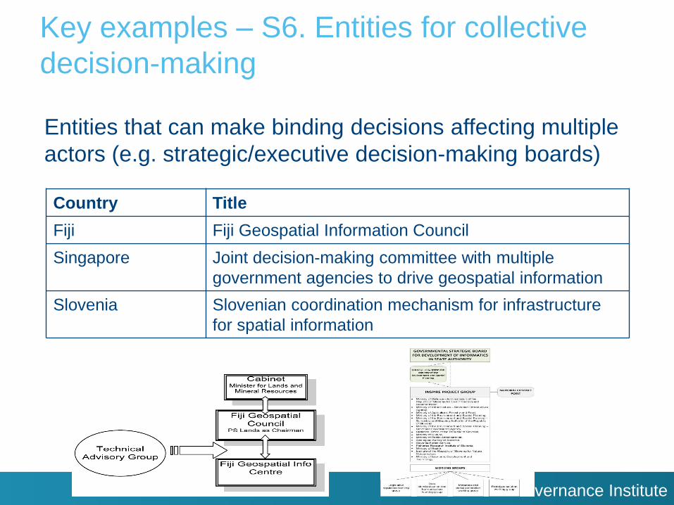
Key examples – S6. Entities for collective
decision-making
Entities that can make binding decisions affecting multiple
actors (e.g. strategic/executive decision-making boards)
Country Title
Fiji Fiji Geospatial Information Council
Singapore Joint decision-making committee with multiple
government agencies to drive geospatial information
Slovenia Slovenian coordination mechanism for infrastructure
for spatial information
Public Governance Institute
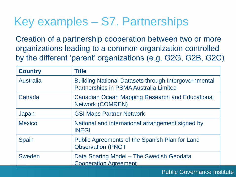
Key examples – S7. Partnerships
Creation of a partnership cooperation between two or more
organizations leading to a common organization controlled
by the different ‘parent’ organizations (e.g. G2G, G2B, G2C)
Country Title
Australia Building National Datasets through Intergovernmental
Partnerships in PSMA Australia Limited
Canada Canadian Ocean Mapping Research and Educational
Network (COMREN)
Japan GSI Maps Partner Network
Mexico National and international arrangement signed by
INEGI
Spain Public Agreements of the Spanish Plan for Land
Observation (PNOT
Sweden Data Sharing Model – The Swedish Geodata
Cooperation Agreement

Public Governance Institute
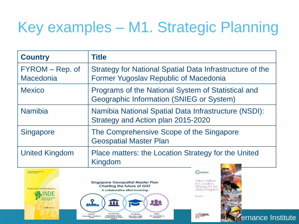
Key examples – M1. Strategic Planning
The existence, implementation status and political support of
strategy plans regarding geospatial information management
in which activities of public organizations are aligned to a
system of interconnected levels of plans, objectives and
targets
Country Title
Australia The Consultative Approach of Australia’s 2026 Spatial
Industry Transformation and Growth Agenda
Brazil Action Plan for the Implementation of INDE
Denmark Good Basic Data Everyone – A driver for growth and
efficiency
Public Governance Institute
Key examples – M1. Strategic Planning
Country Title
FYROM – Rep. of
Macedonia
Strategy for National Spatial Data Infrastructure of the
Former Yugoslav Republic of Macedonia
Mexico Programs of the National System of Statistical and
Geographic Information (SNIEG or System)
Namibia Namibia National Spatial Data Infrastructure (NSDI):
Strategy and Action plan 2015-2020
Singapore The Comprehensive Scope of the Singapore
Geospatial Master Plan
United Kingdom Place matters: the Location Strategy for the United
Kingdom

Public Governance Institute
Key examples – M2. Financial Management:
Input-oriented
Reference to financial management systems encompassing
processes and instruments of budgeting, accounting, and
auditing
Country Title
Bahrein Government Investment in Bahrein Spatial Data
Infrastructure
China Financial investments in Chinese geospatial
information Management
India NSDI Financial Strategy and Funding Models
Mexico Cadastral Modernization Program

Public Governance Institute
Key examples – M3. Financial Management:
Performance-oriented
Results-oriented financial management with emphasis on
organizational incentives for performance
Country Title
Germany Automated performance procedure for German SDI
Monitoring
United Arab
Emirates
Geomaturity Assessment of Abu Dhabi Spatial Data
Infrastructure
USA Geospatial Maturity Assessment
Public Governance Institute
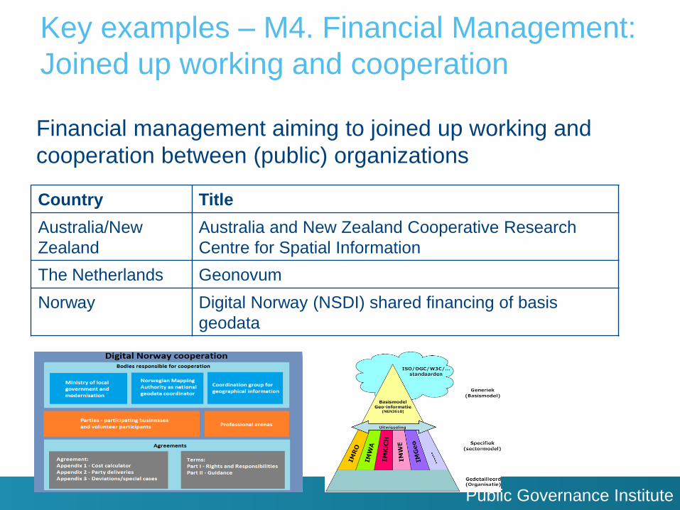
Key examples – M4. Financial Management:
Joined up working and cooperation
Financial management aiming to joined up working and
cooperation between (public) organizations
Country Title
Australia/New
Zealand
Australia and New Zealand Cooperative Research
Centre for Spatial Information
The Netherlands Geonovum
Norway Digital Norway (NSDI) shared financing of basis
geodata
Public Governance Institute
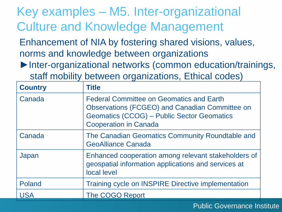
Key examples – M5. Inter-organizational
Culture and Knowledge Management Enhancement of NIA by fostering shared visions, values,
norms and knowledge between organizations
►Inter-organizational networks (common education/trainings,
staff mobility between organizations, Ethical codes)
Country Title
Canada Federal Committee on Geomatics and Earth
Observations (FCGEO) and Canadian Committee on
Geomatics (CCOG) – Public Sector Geomatics
Cooperation in Canada
Canada The Canadian Geomatics Community Roundtable and
GeoAlliance Canada
Japan Enhanced cooperation among relevant stakeholders of
geospatial information applications and services at
local level
Poland Training cycle on INSPIRE Directive implementation
USA The COGO Report
Public Governance Institute
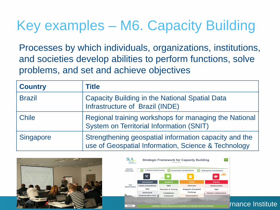
Key examples – M6. Capacity Building
Processes by which individuals, organizations, institutions,
and societies develop abilities to perform functions, solve
problems, and set and achieve objectives
Country Title
Brazil Capacity Building in the National Spatial Data
Infrastructure of Brazil (INDE)
Chile Regional training workshops for managing the National
System on Territorial Information (SNIT)
Singapore Strengthening geospatial information capacity and the
use of Geospatial Information, Science & Technology
Public Governance Institute
Principles & Guidelines
Provision of principles and guidelines regarding the
institutionalization of geospatial information management
for national governments
Partly based on the lessons learnt from the key examples of
good practices of NIA-instruments
Principles: Fundamental beliefs that frame and structure
the entire set of NIA instruments and what they seek to achieve
Guidelines: specific directions on the implementation of each
NIA instrument (or several NIA instruments)
Public Governance Institute
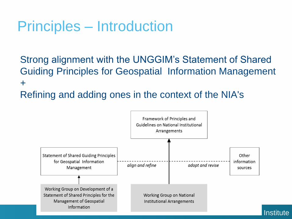
Principles – Introduction
Strong alignment with the UNGGIM’s Statement of Shared
Guiding Principles for Geospatial Information Management
+
Refining and adding ones in the context of the NIA's
Public Governance Institute
Principles
Objectives of the principles:
- to highlight the need to consider NIA-regulations and
coordinating practices in the formation of relevant
MS’ policies and programs
- to cultivate trust in the authoritativeness and reliability
of public sector geospatial information
- to direct the institutional frameworks that govern geospatial
information organizations and ensure there is:
1) commitment to its adoption
2) understanding of its objectives at all political levels
- to stimulate the exchange of good practices in NIAs
- to foster knowledge and cooperation within and among
UN MS predicated on a culture of openness / transparency
Public Governance Institute
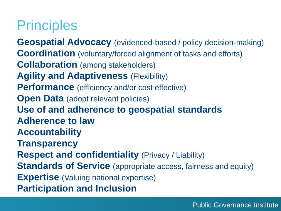
Principles Geospatial Advocacy (evidenced-based / policy decision-making)
Coordination (voluntary/forced alignment of tasks and efforts)
Collaboration (among stakeholders)
Agility and Adaptiveness (Flexibility)
Performance (efficiency and/or cost effective)
Open Data (adopt relevant policies)
Use of and adherence to geospatial standards
Adherence to law
Accountability
Transparency
Respect and confidentiality (Privacy / Liability)
Standards of Service (appropriate access, fairness and equity)
Expertise (Valuing national expertise)
Participation and Inclusion

Public Governance Institute
Principles – NIA-instruments
Public Governance Institute
Guidelines
- More specific to NIAs
- Governments can use them as specific directions on the
implementation of instruments to strengthen the national
institutionalization of GI-management of their country
- ‘Lessons on what to do’ for each NIA-instruments based on
good practices
Public Governance Institute
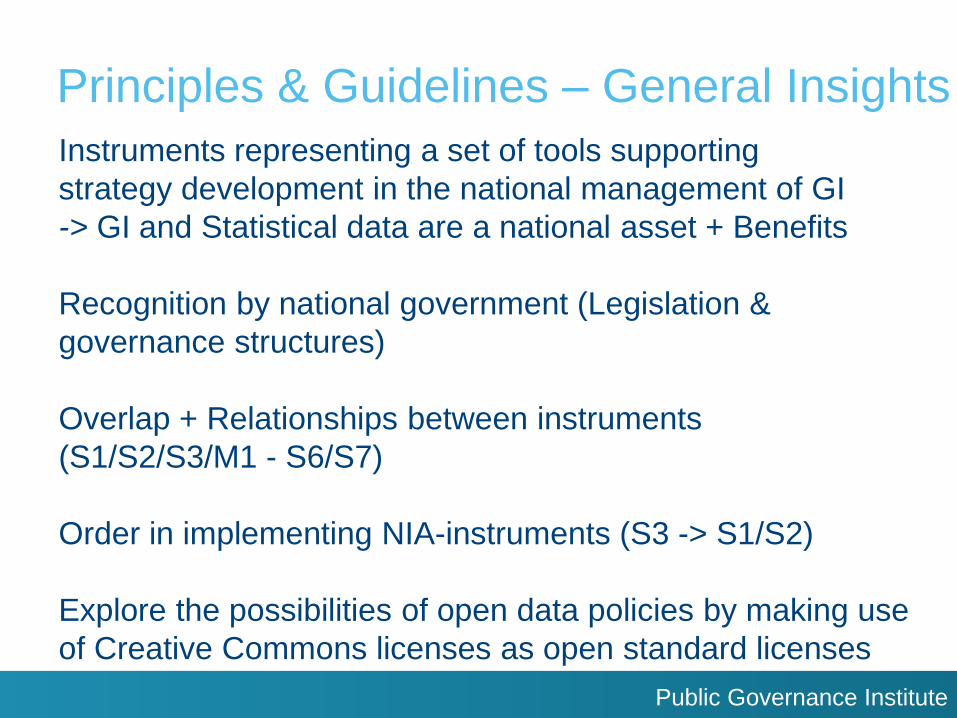
Principles & Guidelines – General Insights
Instruments representing a set of tools supporting
strategy development in the national management of GI
-> GI and Statistical data are a national asset + Benefits
Recognition by national government (Legislation &
governance structures)
Overlap + Relationships between instruments
(S1/S2/S3/M1 - S6/S7)
Order in implementing NIA-instruments (S3 -> S1/S2)
Explore the possibilities of open data policies by making use
of Creative Commons licenses as open standard licenses
Public Governance Institute
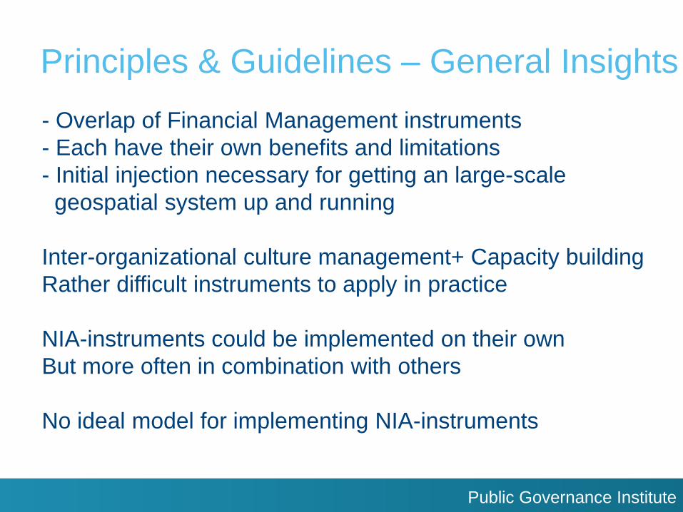
Principles & Guidelines – General Insights
- Overlap of Financial Management instruments
- Each have their own benefits and limitations
- Initial injection necessary for getting an large-scale
geospatial system up and running
Inter-organizational culture management+ Capacity building
Rather difficult instruments to apply in practice
NIA-instruments could be implemented on their own
But more often in combination with others
No ideal model for implementing NIA-instruments
Public Governance Institute
Proposed model of NIA-instrument
Public Governance Institute
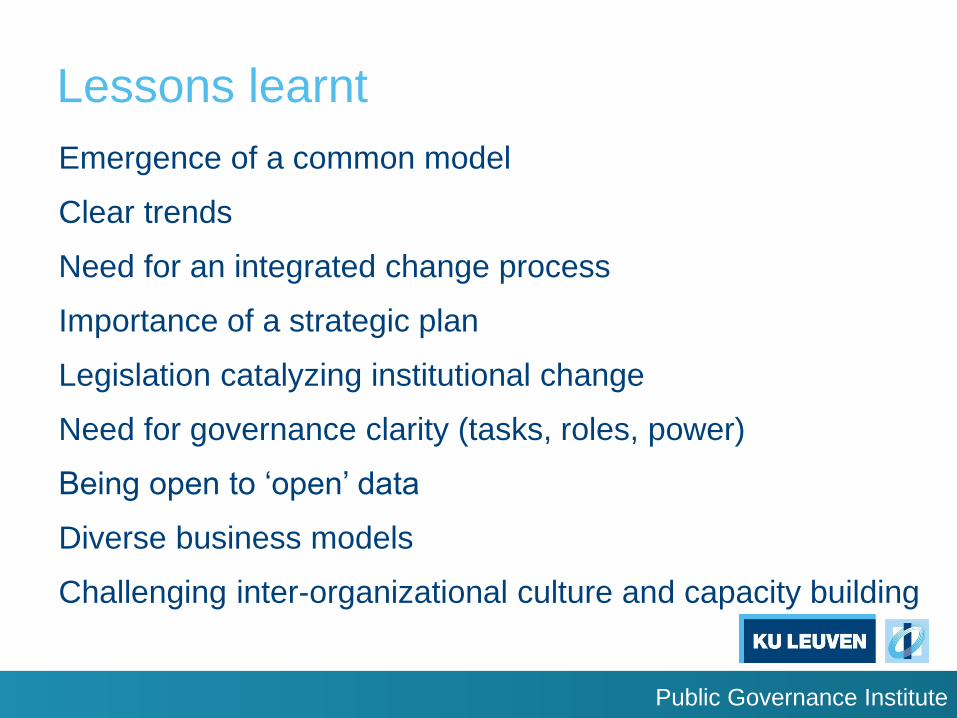
Lessons learnt
Emergence of a common model
Clear trends
Need for an integrated change process
Importance of a strategic plan
Legislation catalyzing institutional change
Need for governance clarity (tasks, roles, power)
Being open to ‘open’ data
Diverse business models
Challenging inter-organizational culture and capacity building

Public Governance Institute
Acknowledgement
Antonio Arozarena, Cecille Blake, Ine Buntinx, Maxim
Chantillon, David Coleman, Andrew Coote, Tomas
Ederborg, Gerardi Esparza, Ana Porcuna Fernández
Monasterio, Carlos Agustin Guerreri Elemen,
Thorben Brigsted Hansen, Mou Jian Lee, Maria
Fernanda Leon Pazmiño, Liyang Lim, Roger
Longhorn, Eva Luevano Orta, Ian Masser, Alvaro
Monett, Francisco Javier Moreno Nuñez, Tomaž
Petek, Bruno Pérez Martin, Lieven Raes, Gregorio
Rosario, Wadih João Scandar Neto, Greg Scott, Ewa
Surma, Timothy Trainor, Nuria Valcárcel Sanz, Glenn
Vancauwenberghe, Ingrid Vanden Berghe, Stijn Wouters,
Siau Yong + Belgium Member State
Public Governance Institute
References used
2016
Public Governance Institute
References used
Public Governance Institute
References used
Public Governance Institute
Contact details
Joep Crompvoets / Serene Ho KU Leuven Public Governance Institute
Parkstraat 45 bus 3609, B-3000 Leuven, Belgium
www.publicgov.eu