Current project funded by JLR ‘TeraSen’ consists of three ... · (off-road all sort of...
24
1
Transcript of Current project funded by JLR ‘TeraSen’ consists of three ... · (off-road all sort of...
1

Current project funded by JLR ‘TeraSen’ consists of three parts:
Terrain identification Road mapping/road profiling Speed over groundStaff involvement: two senior Research fellow, two
research fellow, 3 PhD 50% funded by JLR,50% by UoB
2

3
•Earth remote sensing•Non-destructive testing of structural integrity•Moisture content determination•Coating thickness control•Medical applications•Concealed weapons detection
Self driving/autonomous vehicles
Path finding and obstacles avoidance in robotics

4
Atmospheric gases attenuation•Water vapour absorption•Oxygen absorptionPrecipitation Attenuation •Rain•Snow Foliage BlockageScattering effects

5

6
Icy and Snowy Roads, Grass, Sand, Rough
Gravel, Dirt, etc.
Automotive Drivers AssistanceAutomotive Drivers AssistanceACC and autonomous driving ACC and autonomous driving vehicle controlvehicle control

7
0.5m
4m
10o
40o
20o
24/7, all-weather, robust and compact sensors:Radar and Acoustic Sensors may provide identification by :
Specific polarisation properties of the reflected signalSpecific reflection and absorption rate of radar and acoustic signals
System parameters: Single or multi-frequency? Polarization?Grazing angle?Antenna beamwidth?
Signal processing:Method of classification?Signal parameters used
for classification?

8
Surface classification

9

Aim: real time roads' image and image interpretation in complex environments (off-road all sort of features, humps , kerbs, potholes) in all weather conditions (rain, snow, spray) where traditional sensors fail
Optical sensors are most used driver assistance/path detectionHowever they fail in
• Spray/fog/smoke• Sand/dust storm
Snow/rain
Microwave sensing in THz band providesHigh resolution, ranging,
compact sensors/antennas

11

100 200 300 400 500
50
100
150
200
250
300
350
400
450
Radar image of road path in Cartesian coordinates
100 200 300 400 500
50
100
150
200
250
300
350
400
450
100 200 300 400 500
50
100
150
200
250
300
350
400
450
94 GHz road image feature extraction94 GHz road image feature extractionBy Hough transformBy Hough transform
12

13

The primary speed data for a vehicle comes from the wheel rotation rate.This is not necessarily the true velocity of the vehicle – wheel spin, side slip.
14
If true velocity (speed and direction) is known, automatic systems can be used to aid in recovering control of the vehicle. Developed a multi-sensor platform to evaluate effectiveness of fusion of various sensor types.
◦ Radar Doppler Sensors (x4).◦ Acoustic Doppler Sensors (x4).◦ Inertial Measurement Unit (9 d.o.f.).◦ Low cost GPS.◦ Existing car sensors – e.g. wheel speed, suspension height.◦ Differential GPS – truth data.
1
4
2
3
Example Doppler Sensor Positioning

Data has been collected on and off road with many trajectories and speeds (for post processing).
Current Doppler analysis uses combined information from at least 3 Doppler sensors to estimate transverse and forward velocity, magnitude is then compared to GPS truth data.◦ Currently use spectral centre of mass of Doppler signature to estimate speed of
individual sensor and then compute vehicle velocity.
Currently using only Doppler sensors, average errors are mostly below 4%. ◦ Dependant on terrain, sensor type and speed.
Work is now moving into optimising Doppler speed estimationalgorithms and fusing information from multiple sensor types
(Kalman filter).15
Velocity magnitude comparison
Average radar error 3.4%Average acoustic error 3.3%

2006-2010 long term project funded by DTC and Selex Galileo:
Ground and sea based Forward scatter radar for intruders detection and identification
16

Maritime Ultra-Wideband (UWB) Forward Scatter Radar (FSR) Surveillance Network


Underlying sea clutter level
GPS tracker data for small boat target
Transmitter/Receiver – blueBoat target - yellow
Target becomes visible

Ground CW Forward Scattering Radar (FSR) Surveillance Network

Inter node communication via radar channels
21
Free drop from UAV
GPS positioning
Two ways communication via IRIDIUM SMS
Control point
ATD on sensor board
ATC on CP

22
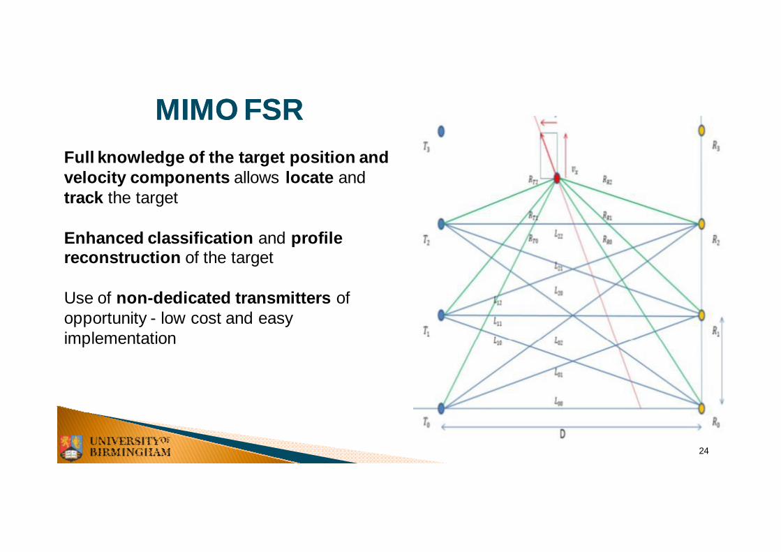
FSR enhanced tracking and imaging:Proposal preparation stage:SISAR target imagingMIMO FSR

23
Shadow ISARShadow ISAR
Inverse diffraction Fresnel transform - target profile
Target signature carries all information on the diffracting contour
utilizes the ISAR effect for the shadow aperture produced byForward Scatter Radar system.
24
MIMO FSRMIMO FSRFull knowledge of the target position and velocity components allows locate and track the target
Enhanced classification and profile reconstruction of the target
Use of non-dedicated transmitters of opportunity - low cost and easy implementation