.. CURRENT CONDITION AND 10-YEAR HISTORIC TREND … · and cultural benefits to local residents,...
41
B.C. Ministry of Forests, Lands and Natural Resource Operations PREPARED BY: Doug Lewis, RPF .. CURRENT CONDITION AND 10-YEAR HISTORIC TREND ANALYSIS FOR MOOSE (ALCES ALCES) POPULATIONS IN THE THOMPSON-OKANAGAN REGION .. MAY 2017
Transcript of .. CURRENT CONDITION AND 10-YEAR HISTORIC TREND … · and cultural benefits to local residents,...

i
B.C. Ministry of Forests, Lands and Natural Resource Operations PREPARED BY: Doug Lewis, RPF
..
CURRENT CONDITION AND 10-YEAR HISTORIC TREND ANALYSIS FOR MOOSE (ALCES ALCES) POPULATIONS IN THE THOMPSON-OKANAGAN REGION ..
MAY 2017

ii
Citation Lewis, D. (2017). Current Condition and 10-Year Historic Trend Analysis for Moose (Alces alces) Populations in the Thompson-Okanagan Region. Ministry of Forests, Lands and Natural Resource Operations. 40pp. Disclaimer This report is in the process of being updated to reflect ongoing moose surveys, inventories and monitoring information, collected by FLNRORD Wildlife Section staff. The context, key factors and risk based assessment approach in this report are still relevant but may be modified slightly to be consistent with the provincial moose assessment protocol procedure. The provincial interim assessment procedure can be reviewed at: https://www2.gov.bc.ca/assets/gov/environment/natural-resource-stewardship/cumulative-effects/cef_assessment_protocol_moose_draft_v10.pdf Acknowledgements This assessment was made possible through valuable contributions and support from many people Special thanks to Sasha Lees and Graham MacGregor for GIS analysis and support. Thanks to Eric Valdal for valuable support and assistance.

iii
Executive Summary Moose are an important species in the Thompson Okanagan Region providing a number of socio-economic and cultural benefits to local residents, including First Nations. In the Thompson-Okanagan Region resident moose hunting generates an estimated $10 million annually as expenditures into the provincial economy, not including non-resident hunting expenditures, income from guide-outfitters, or the less tangible socio-economic and cultural benefits from recreational hunting and meat from successful hunts.
This assessment evaluates the risk of loss of hunting opportunities due to moose population decline in the Thompson Okanagan Region. The assessment evaluates two time periods (2003 and 2014) using an expert-based model, validated with inventory and monitoring data. Factors potentially affecting moose populations considered in the model include: predation (primarily wolves), regulated and non-regulated hunting, forest harvesting and wildfire effects on forage and thermal cover, and livestock effects on forage in wetlands. More current results will be included in a subsequent assessment using an updated assessment procedure that is currently being developed and expected for completion by end of 2019.
The 10-year historic trends (2003-2014) suggest the overall risk of lost hunting opportunities due to moose population decline in the Thompson-Okanagan Region is Moderate to Low. Risk has increased from Low in 2003 but varies across the region due to various factors affecting the moose population, including:
1) High wolf predation rates in the northern portions of the Thompson Rivers and Okanagan Shuswap Resource Districts due to a high density of wolves on moose winter ranges.
2) Increase in habitat-related hazards following MPB salvage on pine-dominated plateaus resulting in extensive cutover areas, reduced thermal/security cover, and open road networks. These conditions increase moose vulnerability to hunting and may reduce availability of effective late winter habitat. Low impacts from regulated and non-regulated hunting. However, hunting pressure can contribute to population impacts where other factors (predation, habitat loss) are affecting the population.
Several High risk areas have been identified where moose populations are stable to declining, and that support considerable moose habitat and hunting opportunity. In those high risk areas, regional wildlife and ecosystems staff are undertaking a number of management actions to monitor and manage impacts, including:
• Increased moose population surveys and censuses; • Research, as part of an ongoing provincial project, using GPS collars to investigate causes of adult
and juvenile mortality and habitat use ; • Extension with forest licensees to raise awareness of habitat and road access issues; and, • Modification of Limited Entry Hunt (LEH) and General Open Season (GOS) hunting in some Wildlife
Management Units (WMU) to reduce hunting pressure.
Monitoring information from hunter harvest information and aerial surveys suggest observed trends in moose populations are consistent with modelled outcomes. Confidence in the assessment outcomes presented here is rated as Moderate to High.

iv
Table of Contents Executive Summary ............................................................................................................................................ iii
1. Introduction ................................................................................................................................................ 6
1.1 General Ecology and Habitat .................................................................................................................... 6
1.2 Distribution and Abundance .................................................................................................................... 6
1.3 Socio-Economic and Cultural Importance ................................................................................................ 7
1.4 Regulatory Framework for Moose Management in B.C. ......................................................................... 8
Provincial Status .......................................................................................................................................... 8
Population Management ............................................................................................................................ 8
Habitat Management .................................................................................................................................. 9
2. Assessment Approach ............................................................................................................................... 10
2.1 Assessment Units ................................................................................................................................... 10
2.3 Assessment Scenarios ............................................................................................................................ 14
2.4 Consequence Ratings ............................................................................................................................. 14
2.5 Hazard Ratings ....................................................................................................................................... 16
2.6 Risk Ratings ............................................................................................................................................ 17
2.7 Use of Inventory and Monitoring Data to Validate Assessment Results ............................................... 18
2.8 Communicating Uncertainty and Confidence ........................................................................................ 18
3. Assessment Results ................................................................................................................................... 20
3.1 Current Condition and Historic Trend .................................................................................................... 20
Moose Population Hazards and Risk ......................................................................................................... 20
3.2 Ongoing Management Responses to Hazard and Risk ........................................................................... 24
3.3 Confidence in Risk Ratings ..................................................................................................................... 24
4. Next Steps ................................................................................................................................................. 26
5. References Cited ....................................................................................................................................... 27
Appendix 1 – Summary of Moose Habitat Regulations by Resource District ................................................... 28
Appendix 2 – Structure of Expert Based Bayesian Belief Model ...................................................................... 30
Appendix 3 – Description of GIS Indicators used as inputs to the Expert Model ............................................. 31
Appendix 4 – Deriving Moose Population Estimates from Hunter Success data from Limited Entry Hunt Statistics ............................................................................................................................................................ 34
Appendix 5 – Merritt TSA Hazard and Risk Ratings Table ................................................................................ 36
Appendix 6 – Lillooet Hazard and Risk Ratings Table ....................................................................................... 37
Appendix 7 – Clearwater Hazard and Risk Ratings Table ................................................................................. 38
Appendix 8 – Kamloops Hazard and Risk Ratings Table ................................................................................... 39
Appendix 9 – Okanagan North Hazard and Risk Ratings Table ......................................................................... 40
Appendix 10 – Okanagan South Hazard and Risk Ratings Table ....................................................................... 41

v
This page is intentionally left blank.
6
1. Introduction
1.1 General Ecology and Habitat Moose (Alces alces) are the largest member of the deer family (Cervidae), and are the largest ungulate species in British Columbia (B.C.) (BCMELP, 2000). Adult moose are horse-sized, standing as much as two metres tall and weighing on average between 340 to 420kg for adult cows and 450 to 500kg for adult bulls. Only male (bull) moose have antlers that are distinguished by the large, palmate form compared to the slender branching pattern of other cervids. Moose are also easily distinguishable from other cervids by their long, slender legs, large body, shoulder hump, and a dark brown-blackish coat.
Moose are herbivorous and utilize a variety of habitats from heavily forested to open, recently disturbed areas to wetland and riparian areas. In the spring and summer moose forage primarily on leaves and stems of wood plants, but will also use aquatic vegetation. In the winter months, when plant dormancy limits foraging opportunities, their diet shifts to the woody stems of shrubs. Being such large animals, moose must eat up to 20 kg of food every day in winter to meet their energy needs. Preferred browse plants include: willows (Salix spp.), red osier dogwood (Cornus sericea), Saskatoon (Amelanchier alnifolia), high bush cranberry (Viburnum edule), bog birch (Betula glandulosa), lodgepole pine (Pinus contorta), paper birch (Betula papyrifera), and mountain ash (Sorbus Sitchensis).
Four general seasons have been recognized as important for providing foraging, thermal, hiding or snow interception cover for moose, including: Summer (July to August), early Winter (September to December), Late winter (January to April) and Calving Season (May to June). Late winter and Calving seasons are considered the most critical as foraging and thermal cover habitats are most limiting. Seasonal movements are largely determined by the depth and duration of snow cover (BCMELP 2000). Their long legs allow moose to move through deep snow up to 60cm in depth enabling moose stay on high elevation ranges much longer than other ungulates (BCMWLAP, 2005). However, snow depths of 60 to 90cm may inhibit movements and >90cm may severely restrict movements. In mountainous regions of B.C. where snow accumulations are greater, moose usually migrate to lower elevation winter-spring ranges in valley bottoms returning to higher-elevation calving and summer ranges, although some moose remain in valleys year round. On plateaus, moose concentrate along river valleys that cut through the plateaus, and in burns, logged areas and wetland complexes. In many dry interior plateau habitats that receive less precipitation, lower snow accumulations may allow moose to remain at higher elevations until late winter or even throughout the year.
Moose are well adapted to snowy and cold environments and their thick winter coat allows them to tolerate temperatures down to -25oC. However, moose will seek out thermal cover to stay cool in the late Winter Season where temperatures above -5o C cause moose to increase respiration rates. Studies have shown that moose alter daily patterns of behaviour and habitat use to stay cool (Renecker and Hudson, 1986).
1.2 Distribution and Abundance Moose are the most widely distributed ungulate in B.C., occupying most areas except the very dry valley bottoms of the Thompson and South Okanagan, and are generally absent from the coast (Figure 1). However, recent evidence suggests range expansion by moose into coastal temperate rainforest environments (Darimont et al. 2005). In the Thompson-Okanagan Region, moose are found throughout most ecosystems except the Bunchgrass (BG) and Ponderosa Pine (PP) Biogeoclimatic zones, although moose have been observed in aspen copses in both zones (Lemke, 2000).

7
Figure 1. Current estimated distribution and relative abundance of Moose in British Columbia (Figure copied from BCMELP, 2000).
The current moose population in the Thompson-Okanagan Region is estimated at 10-15,000 animals1. Population densities vary considerably throughout the region depending on habitat quality and availability. In winter, typical moose population densities range from 0.3 moose/km2 to 1.5/km2 (BCMELP, 2000).
1.3 Socio-Economic and Cultural Importance Moose are broadly recognized as important to the people of B.C., from their key role in ecosystem function, to the cultural, social and economic benefits derived from their use. First Nations peoples used moose prior to European contact and settlement (BC MELP, 2000). Moose were often a main source of meat; moose hides were used for clothing and shelter and bones and antlers were used to make a variety of tools. Moose continue to be a source of sustenance to First Nations communities and moose hunting is recognized as an important part of First Nations culture. Moose remain one of the most important game species to residents in B.C. (BC MELP 2000). Provincially, annual moose harvest from 2007-2015 was estimated at approximately 19,000-23,0002. In Region 3, which covers a large portion of the Thompson-Okanagan Region, annual resident harvest from 2007-2015 ranged from approximately 4,000-6,500 animals. Moose hunting generates license revenue, income for guide outfitters and considerable recreational opportunities for residents. Provincially, moose hunting resulted in approximately 375,000-500,000 annual hunter days during the period from 2007-2015. In Region 3, about 75,000-117,000 days were spent hunting moose annually in that same period.
The economic revenue generated from moose hunting in the Province and the Thompson-Okanagan Region can be considerable. Survey information from the 2012/13 hunting season estimated that B.C. resident moose hunter expenditures3 exceed $70 million for that season. In Region 3 and 8, resident moose hunting 1 Frequently asked questions: Moose harvest strategies in South-Central B.C. (Cariboo, Thompson, Okanagan, Kootenay, Omenica), Fish, Wildlife and Habitat Management Branch, B.C. Ministry of Forests, Lands and Natural Resource Operations, July 18, 2011 2 Provincial big game harvest statistics provided by B.C. Ministry of Forests, Lands and Natural Resource Operations, Fish and Wildlife Branch. 3 Expenditures include food and beverages, lodging, fuel, hunting and associated equipment, licenses and tags, processing and taxidermy and large purchases such as vehicles, campers, boats, etc. used primarily for hunting. Expenditures estimated here are for resident hunters only, non-resident

8
expenditures were estimated at $6.7 and $8.3 million respectively for that same year. These estimates do not include the less tangible recreational benefits from moose hunting and the socio-economic and/or cultural benefits derived from the meat the successful hunters take home.
1.4 Regulatory Framework for Moose Management in B.C.
Provincial Status Moose are yellow listed and ranked as (S5) under Provincial Conservation Status4, meaning moose populations are demonstrably abundant, widespread and secure. However, given their cultural and socio-economic importance as a hunted species, moose are a species of management concern in B.C. and specific habitat and population management guidelines have been established to manage moose populations.
Population Management As stated in the Draft Provincial Framework for Moose Management in British Columbia (BCMFLNRO, 2013)5; “the goal of moose management is to ensure moose are maintained as integral components of natural ecosystems throughout their range, and maintain sustainable moose populations that meet the needs of First Nations, licensed hunters and the guiding industry. The objectives for moose management are to:
1. Ensure opportunities for consumptive use of moose are sustainable; 2. Maintain a diversity of hunting opportunities; and, 3. Follow provincial policies and procedures (e.g. provincial moose harvest management procedure) as
guidance for regulatory options and management objectives”.
To sustainably manage consumptive use, the Wildlife Act of British Columbia provides the Minister responsible to issue hunting licenses, set bag limits, hunting seasons for non-aboriginal residents and non-residents and set quotas for guide-outfitters based on resident/non-resident allocation. Regional MFLNRO Wildlife Biologists monitor moose populations to advise on appropriate hunting seasons, bag limits and quotas by management unit in each region. In B.C., sustainable harvest rates are around 3% to 9% depending on population objectives and demographics.
The following steps are used to determine Annual Allowable Harvest (AAH)6:
1. Biologists conduct a moose population assessment and determine a “maximum allowable mortality level”;
hunters’ expenditures and guide-outfitter revenues are not included. Source: Expenditures of British Columbia Resident Hunters. 2013. Unpublished report conducted for B.C. Ministry of Forests, Lands and Natural Resource Operations, by Responsive Management. Available at: http://www.env.gov.bc.ca/fw/wildlife/docs/bc_hunting_expenditure_rpt_2013.pdf 4 See the B.C. Species and Ecosystems Explorer at the B.C. Ministry of Environment website: http://www.env.gov.bc.ca/atrisk/toolintro.html to look up species conservation status and ranking definitions. 5 Draft Provincial framework for Moose Management in British Columbia. B.C. Ministry of Forests, Lands and Natural Resource Operations, Fish Wildlife and Habitat Management Branch, Victoria , B.C. August 2013 http://www.env.gov.bc.ca/fw/wildlife/management-issues/ 6 Frequently asked questions: moose harvest strategies in South-Central B.C. (Cariboo, Thompson, Okanagan, Kootenay, Omenica), Fish, Wildlife and habitat Management Branch, B.C. Ministry of Forests, Lands and Natural Resource Operations, July 18, 2011

9
2. Biologists then estimate or otherwise account for First Nations harvest; 3. Others sources of human-caused mortality, such as road/rail mortality, may be estimated if
substantive levels present; and, 4. The AAH is then determined by subtracting First Nations harvest. The AAH is therefore the number
of moose available to be harvested by licensed hunters each year. The number of moose available to licensed hunters is managed through hunting regulations, and includes:
• Restrictions on hunting females (cows) and young (calves) through Limited Entry Hunting (LEH) to ensure adequate adult female survival and population recruitment; and,
• Restrictions on timing and age and sex (spike fork harvest) for General Open Seasons (GOS).
Habitat Management Under the B.C. Identified Wildlife Strategy moose are identified as an ungulate species that may require management of winter range habitats for winter survival7.Two primary regulatory tools exist to manage winter range habitats:
1. The Wildlife Act of British Columbia provides the Minister responsible the ability to acquire, administer or designate areas (i.e. Wildlife Management Areas-WMAs) to manage and protect wildlife, and
2. The Forest and Range Practices Act (FRPA) contains objectives set by Government for wildlife under Section 7(2) of the Forest Planning and Practices Regulation and Section 9(3) of the Woodlot License Planning and Practices regulation, and authorizes the Minister responsible to establish ungulate winter range areas (UWRs) or Wildlife Habitat Areas (WHAs) and specify objectives and General Wildlife Measures (GWMs).
UWRs, WHAs and GWMs are established under a Government Action Regulation (GAR) Order under the FRPA. Forest Act tenure holders with replaceable forest licenses that are required to prepare a Forest Stewardship Plan (FSP) must specify results and strategies that are consistent with the objectives specified in the GAR order.
Legal objectives for identified moose winter range habitats in the Thompson-Okanagan Region vary considerably between Natural Resource Districts and Timber Supply Areas depending on the history of land use planning (Appendix 1). In general, habitat measures are focused on maintaining adequate levels of key habitat requisites including forage, thermal and hiding cover affected by forest harvesting and livestock/range management practices.
7B.C. Identified Wildlife Management Strategy http://www.env.gov.bc.ca/wld/frpa/species.html
10
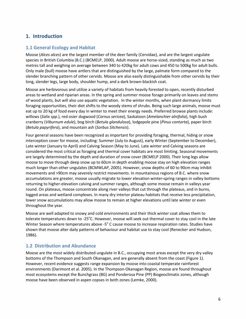
2. Assessment Approach The moose assessment uses a risk-based approach as described in Wise et al. (2004) and CSA (1997), where risk is the product of hazard and consequence defined by the risk equation; Risk = Hazard x Consequence. The assessment provides a risk rating for each moose ‘planning cell’ (see Section 2.1 Assessment Unit) interpreted against draft provincial moose management objectives8, where risk is a defined as a loss of hunting opportunities due to a decline in moose populations9. Risk ratings are based on consequence and hazard ratings derived for each planning cell combined in a risk matrix (Fig. 2).
Figure 2. Risk matrix used in the Moose Population Risk Assessment
Factors that contribute to moose population decline (hazards) are measured using GIS indicators output as hazard ratings using an expert-judgement-based (expert) moose population assessment model (Wilson, 2014: Appendix 2 and 3). Consequence ratings are assigned based on qualitative estimates of the socio-economic loss associated with lost hunting opportunities. A more detailed explanation of how consequence and hazard ratings are used to assess moose population risk is provided in subsequent sections.
2.1 Assessment Units The assessment was completed for the entire Thompson-Okanagan Region including the Lillooet and Merritt TSAs (Cascades Resource District), Kamloops TSA (Thompson River s District) and Okanagan Shuswap TSA (Resource District).
8 Assessments related to specific legal habitat objectives for moose, where they exist and can be measured, are completed in different reports. 9 Regulated moose hunting opportunities are managed annually to minimize impacts of hunting on the population. The decline described here is considered both persistent (5+years) and significant enough to not sustain previous regulated and non-regulated (e.g. aboriginal) hunting levels.

11
Figure 3. An illustration of the broader Thompson Okanagan Region assessment area showing the extent Wildlife Management Units (WMUs; green shaded areas) that are currently included in the assessment.
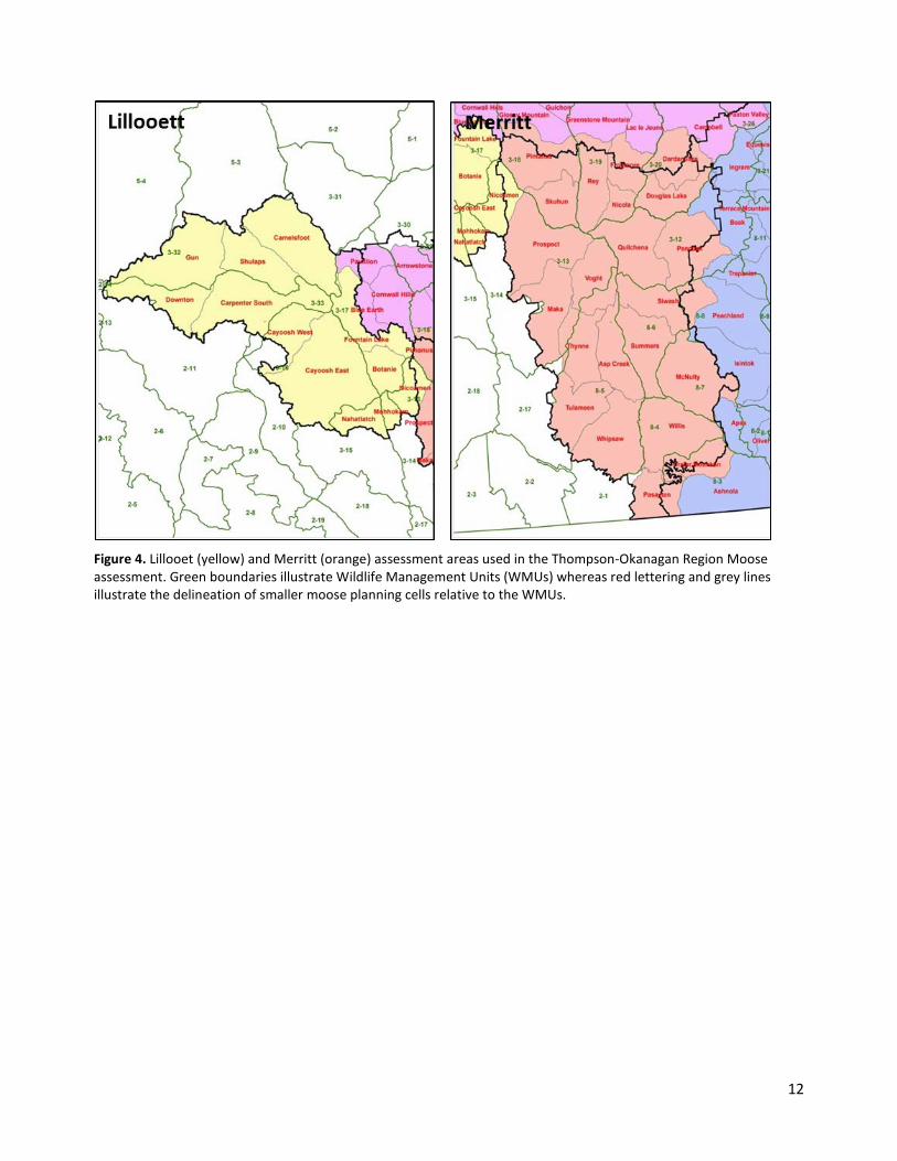
Existing Wildlife Management Units (Figure 3) used for moose population management were considered too broad to capture more local habitat and human access (hunting) related effects on moose. As a result moose ‘planning cells’ were developed as an assessment and reporting unit that divides existing WMUs into smaller sub-section based on logical boundaries to human development including existing major highways or roads, major rivers or lakes or topographic features (Figures 4 and 5). The division of the land-base into planning cells also facilitates the use of assessment outcomes in planning and implementation of mitigation activities directed at habitat or human access.
12
Figure 4. Lillooet (yellow) and Merritt (orange) assessment areas used in the Thompson-Okanagan Region Moose assessment. Green boundaries illustrate Wildlife Management Units (WMUs) whereas red lettering and grey lines illustrate the delineation of smaller moose planning cells relative to the WMUs.

13
Figure 5. Clearwater (light blue), Kamloops (pink), North Okanagan (blue-left) and South Okanagan (blue right) assessment areas used in the Thompson-Okanagan Region moose assessment. Green boundaries illustrate Wildlife Management Units (WMUs) whereas red lettering and grey lines illustrate the delineation of smaller moose planning cells relative to the WMUs.

14
2.3 Assessment Scenarios The assessment procedure runs an analysis of landscape condition and reports out at three time periods:
• Historic condition to 2003 – historic landscape condition including existing levels of forest harvesting, road networks and other land use activity was re-created to 2003 using archived datasets.
• Current condition (2014) – current landscape condition including existing levels of forest harvesting, road networks and other land use activity was produced using updated datasets.
2.4 Consequence Ratings Consequence is defined as is the effect on human well-being, property, the environment, or other things of value; or a combination of these (Vandine et al. 2004). Moose are primarily valued by humans for the socio-economic benefits derived from sustenance and recreational hunting. Provincial goals and objectives for moose management in B.C. are to “maintain sustainable moose populations that meet the needs of First Nations, licensed hunters and the guiding industry”. 10
In this procedure, consequence refers to the socio-economic and cultural effects due loss of hunting opportunities for First Nations, licensed hunters and the guiding industry due to moose population decline. The types of effects include:
• Social and cultural impacts to First Nations peoples due to loss of sustenance hunting, or for social or ceremonial purposes;
• Social impacts due to loss of recreational and sustenance hunting opportunities for non-aboriginal residents;
• Loss of economic revenue to the Province from reduced licensing fees; • Loss of economic revenue in local communities from hunting-related tourism or activity (e.g.
purchasing of fuel); and, • Loss of economic revenue to guide outfitters.
Consequence ratings are used to express estimates of the likelihood of an effect or outcome should a harmful situation occur. Consequence ratings used in this assessment are intended to provide a qualitative estimate of the relative importance or worth of a moose planning cell, at the regional level, to providing hunting opportunities. Consequence ratings are based on two sources of information (Figure 6):
1. The total amount of and quality of capable winter habitat as an indicator of the ecological potential to support moose; and,
2. Hunting effort as an indicator of socio-economic worth of hunting, based on average annual number of hunter days from 1976-2010 using General Open Season (GOS) hunter survey data.
Consequence ratings should not be misinterpreted to infer that any individual planning cell is less important ecologically or to hunters/guide outfitters/First Nations that use that local area. Moose populations are important in all areas and will continue to be managed through existing regulations and management actions. The consequence ratings are intended to identify areas within the region that may require additional management attention for moose beyond existing measures. First Nations or individual stakeholders can apply their own consequence ratings to assess risk within their own area of interest.
10 Draft Provincial framework for Moose Management in British Columbia. B.C. Ministry of Forests, Lands and Natural Resource Operations, Fish Wildlife and Habitat Management Branch, Victoria , B.C. August 2013 http://www.env.gov.bc.ca/fw/wildlife/management-issues/

15
Figure 6. Habitat Capability (left) in the Thompson Okanagan region and average hunter days by WMU from 1976-2010 (right) based on hunter survey information.
To derive consequence ratings, hunter days for each moose planning cell were first estimated based on hunter information from overlapping WMUs and the amount and quality of capable winter habitat. Planning cells within a WMU with less capable habitat were assigned a lower proportion of hunter days. Each planning cell was then assigned consequence rating of Low, Moderate or High. In general, High consequence planning cells have >60% of the area as capable habitat, a higher proportion of Moderate-Highly rated capable habitat and >500 estimated average annual hunter days. Low consequence planning cell generally have <30% capable winter habitat and support <150 average annual hunter days.
The Moderate and High rated planning cells focus on planning cells with the highest concentration of moderate-high capability habitat and average hunter days. These areas fall in the central portion of the region on the Bonaparte, Guichon and Okanagan plateaus that straddle the Kamloops, Merritt and Okanagan-Shuswap areas (Figure 7). The 51 Moderate and High rated planning cells out of the 115 total planning cells in the Thompson-Okanagan region account for close to 60% of the total capable habitat in the region, as much as 60-65% of the total moose population and 70% of total average hunter days.
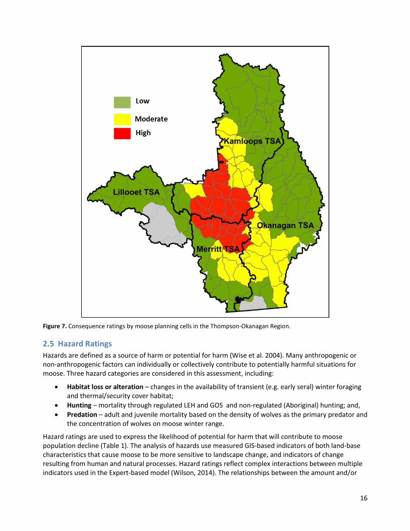
16
Figure 7. Consequence ratings by moose planning cells in the Thompson-Okanagan Region.
2.5 Hazard Ratings Hazards are defined as a source of harm or potential for harm (Wise et al. 2004). Many anthropogenic or non-anthropogenic factors can individually or collectively contribute to potentially harmful situations for moose. Three hazard categories are considered in this assessment, including:
• Habitat loss or alteration – changes in the availability of transient (e.g. early seral) winter foraging and thermal/security cover habitat;
• Hunting – mortality through regulated LEH and GOS and non-regulated (Aboriginal) hunting; and, • Predation – adult and juvenile mortality based on the density of wolves as the primary predator and
the concentration of wolves on moose winter range.
Hazard ratings are used to express the likelihood of potential for harm that will contribute to moose population decline (Table 1). The analysis of hazards use measured GIS-based indicators of both land-base characteristics that cause moose to be more sensitive to landscape change, and indicators of change resulting from human and natural processes. Hazard ratings reflect complex interactions between multiple indicators used in the Expert-based model (Wilson, 2014). The relationships between the amount and/or

17
extent of measured GIS-indicators and the probability of a Low, Moderate or High impact to moose are used to define the likelihood of a hazardous situation, and are detailed in the expert model.
Table 1. Terminology used to describe hazard ratings11. From Lewis et al., 2016.
Hazard Rating Likelihood of Occurrence Probability of Occurring (%)
Low <33% Unlikely that harmful situation exists that will contribute to moose population decline
Moderate 33-66% About as likely as not that a harmful situation exists that will contribute to moose population decline
High >66% Likely that a harmful situation exists that will contribute to moose population decline
2.6 Risk Ratings Risk is the chance of injury or loss as defined as a measure of the probability and the consequence of adverse effects to health, property, the environment, or other things of value (Wise et al. 2004). In this assessment, risk refers to the risk of lost hunting opportunities due to moose population decline. Risk ratings provide an estimate of the likelihood that risk will occur (Table 2), and are based on the relative weightings of the various hazards that affect moose adult survival and recruitment as described in the expert model (Wilson, 2014) and the importance of the area for moose hunting (consequence).
Table 2. Terminology and description used in risk ratings.
Risk Rating Likelihood of Occurrence
Consistent with Draft Provincial Moose
Management Objectives? Risk Description
Low <33% Yes
Unlikely that hunting opportunities will be lost, Increasing to stable moose population that can sustain hunting effort and success at desired levels.
Moderate 33-66% Yes
About as likely as not hunting opportunities will be lost, and moose population can sustain hunting effort and success at desired levels.
High >66% No
Likely that hunting opportunities will be lost. Moose population cannot sustain hunting effort and success at desired levels.
The risk ratings derived from the expert model are interpreted against the following policy objectives identified in the Draft Provincial Framework for Moose Management in British Columbia (2013):
1. Ensure opportunities for moose consumptive use are sustainable; and 2. Maintain a diversity of hunting opportunities for moose.
Under a high risk rating, populations are likely to have declined or are declining to a level that consumptive use cannot be sustained at desired levels, and diverse hunting opportunities (including Aboriginal ,
11 Likelihood statements follow recommended terminology from the Intergovernmental Panel on Climate Change (IPCC) Guidance Notes for Lead Authors of the IPCC Fourth Assessment Report on Addressing Uncertainties, July 2005.

18
recreational, guide-outfitting) cannot be maintained12. Thus, the high risk rating is considered to be inconsistent with the draft provincial objectives.
2.7 Use of Inventory and Monitoring Data to Validate Assessment Results To help validate expert model results used in the hazard analysis, existing inventory or monitoring information are used to evaluate whether hazards identified to cause moose population decline are resulting in observable changes in moose numbers. The following inventory and monitoring sources were used:
• Hunter Reporting o Hunter success and hunter effort (# of days) reported annually since 1984
• Aerial Composition Survey o Bull:Cow:Calf ratio o Rough population estimate based on # of moose counted
• Aerial Stratified Random Block (SRB) Survey o Stratify habitat by quality (Low, Moderate, High) o Count number of moose spotted from aircraft in each strata o Population estimated (corrected) based on # of moose spotted o Also provide a composition estimate (Bull:Cow:Calf)
Hunter reporting (hunter success from LEH) is used to estimate population abundance using a statistically derived relationship, and provides evidence of trends over time (See Appendix 4). Aerial composition survey and SRB survey data is used to estimate population abundance at a given time, and provides increased confidence when used with population estimates derived from the hunter reporting data. Composition estimates provide additional evidence of trends in the proportion of males to females (cow: bull ratio) or young to adult females (cow: calf ratio). This information provides insight into whether effects are related to predators (adult female survival or calf recruitment, or hunting pressure affecting primarily males (cow: bull ratio).
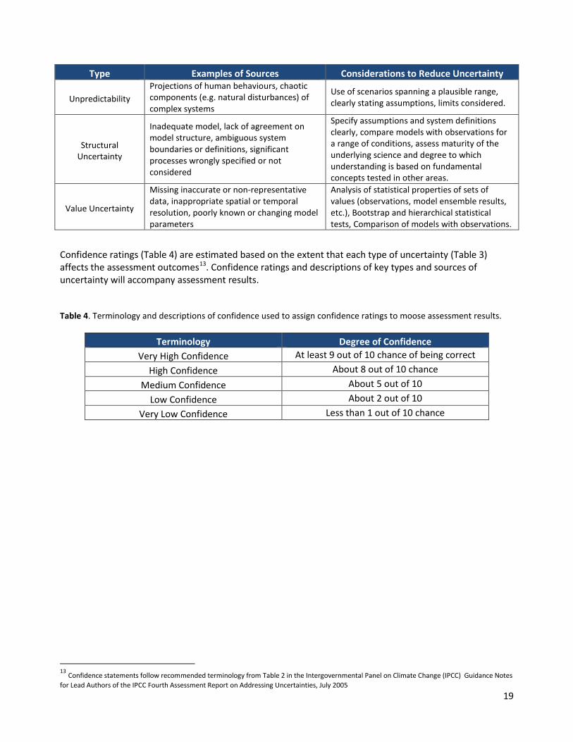
2.8 Communicating Uncertainty and Confidence All forms of assessment, particularly those involving complex ecological systems and unpredictable human behaviours, involve uncertainty (Table 3). Strategic-level assessment procedures, such as this, have particular uncertainties inherent with the broad-scale and time frames involved, generalizations used to characterize ecological systems and human behaviours and ‘coarse’ data or information sources used in the analysis. Uncertainty and is an integral part of risk and risk management, therefore understanding and communicating types of uncertainty and confidence is fundamental to understanding assessment outcomes and informing management actions.
Table 3. A typology of uncertainties, sources and considerations to reduce uncertainties. Adapted from IPCC (2005).
12 The draft provincial moose management objectives are not measurable, so present a challenge to evaluate if objectives are being achieved. In this assessment, use of the expert model to determine the likelihood of moose population decline, and interpretation of high likelihood as inconsistent with the draft provincial objectives, is the assessor’s interpretation of a measurable ‘assessment endpoint’ consistent with guidance from the USEPA Framework for Ecological Risk assessment ( 1992) and Generic Ecological Assessment Endpoints for Ecological Risk Assessment (2003).
19
Type Examples of Sources Considerations to Reduce Uncertainty
Unpredictability Projections of human behaviours, chaotic components (e.g. natural disturbances) of complex systems
Use of scenarios spanning a plausible range, clearly stating assumptions, limits considered.
Structural Uncertainty
Inadequate model, lack of agreement on model structure, ambiguous system boundaries or definitions, significant processes wrongly specified or not considered
Specify assumptions and system definitions clearly, compare models with observations for a range of conditions, assess maturity of the underlying science and degree to which understanding is based on fundamental concepts tested in other areas.
Value Uncertainty
Missing inaccurate or non-representative data, inappropriate spatial or temporal resolution, poorly known or changing model parameters
Analysis of statistical properties of sets of values (observations, model ensemble results, etc.), Bootstrap and hierarchical statistical tests, Comparison of models with observations.
Confidence ratings (Table 4) are estimated based on the extent that each type of uncertainty (Table 3) affects the assessment outcomes13. Confidence ratings and descriptions of key types and sources of uncertainty will accompany assessment results.
Table 4. Terminology and descriptions of confidence used to assign confidence ratings to moose assessment results.
Terminology Degree of Confidence Very High Confidence At least 9 out of 10 chance of being correct
High Confidence About 8 out of 10 chance Medium Confidence About 5 out of 10
Low Confidence About 2 out of 10 Very Low Confidence Less than 1 out of 10 chance
13 Confidence statements follow recommended terminology from Table 2 in the Intergovernmental Panel on Climate Change (IPCC) Guidance Notes for Lead Authors of the IPCC Fourth Assessment Report on Addressing Uncertainties, July 2005

20
3. Assessment Results
3.1 Current Condition and Historic Trend
Moose Population Hazards and Risk The 10-year historic trends (2003-2014) suggest an increased in hazard from 2003 to 2014 (Figure 8) that varies considerably across the region due to a number of factors:
1. High wolf predation rates in the northern portions of the Thompson Rivers and Okanagan Shuswap Resource Districts due to a high density of wolves on moose winter range have resulted in declines in moose populations in those areas. Anecdotal observations and survey information suggests the distribution of wolves has shifted south into the central portion of the region, and wolf density has recently declined in the northern portions.
2. Increase in habitat-related hazards in the Kamloops, South Okanagan and parts of the Merritt areas due to loss of thermal cover habitats, more extensive early seral areas and open road networks following MPB salvage on pine-dominated plateaus. Extensive cutover areas, reduced thermal/security cover, and open road networks can increase moose vulnerability to hunting and may reduce availability of effective late winter habitat where adjacent forage and thermal cover is reduced.
3. Regulated and non-regulated hunting impacts are generally considered low. However, hunting pressure can contribute to population impacts where other factors (predation, habitat loss) are affecting the population.
Figure 8. Thompson-Okanagan Region Moose hazard ratings for 2003 and 2014. Grey areas indicate where no capable moose habitat is identified. Tabular results by planning cells are summarized from Appendix 6 for Lillooet TSA and Appendix 10 for Okanagan TSA (south portion).
21
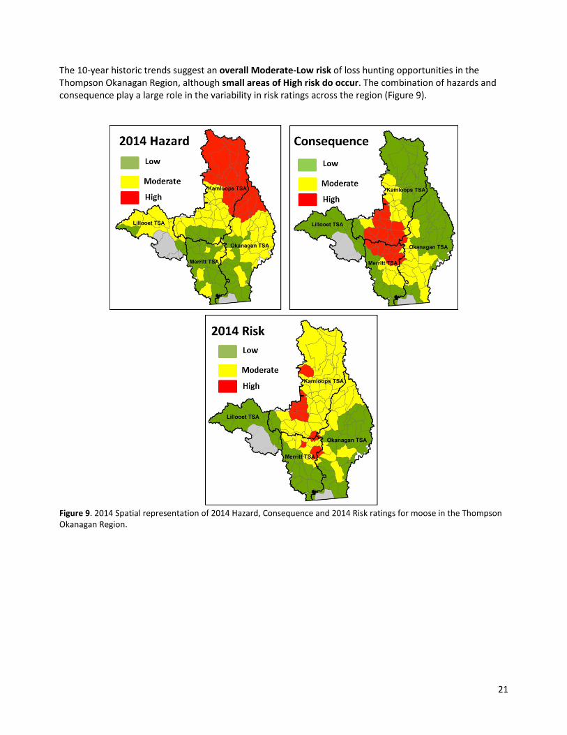
The 10-year historic trends suggest an overall Moderate-Low risk of loss hunting opportunities in the Thompson Okanagan Region, although small areas of High risk do occur. The combination of hazards and consequence play a large role in the variability in risk ratings across the region (Figure 9).
Figure 9. 2014 Spatial representation of 2014 Hazard, Consequence and 2014 Risk ratings for moose in the Thompson Okanagan Region.
22
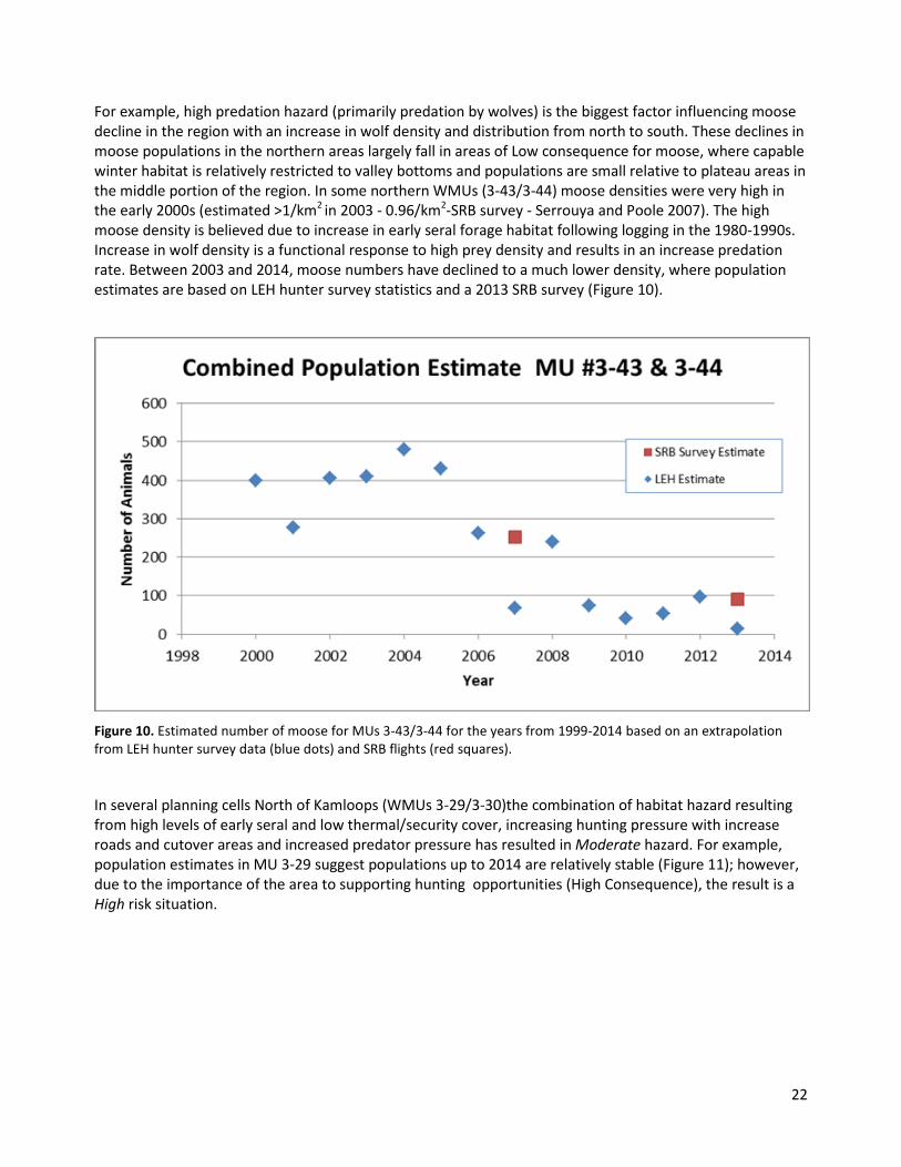
For example, high predation hazard (primarily predation by wolves) is the biggest factor influencing moose decline in the region with an increase in wolf density and distribution from north to south. These declines in moose populations in the northern areas largely fall in areas of Low consequence for moose, where capable winter habitat is relatively restricted to valley bottoms and populations are small relative to plateau areas in the middle portion of the region. In some northern WMUs (3-43/3-44) moose densities were very high in the early 2000s (estimated >1/km2 in 2003 - 0.96/km2-SRB survey - Serrouya and Poole 2007). The high moose density is believed due to increase in early seral forage habitat following logging in the 1980-1990s. Increase in wolf density is a functional response to high prey density and results in an increase predation rate. Between 2003 and 2014, moose numbers have declined to a much lower density, where population estimates are based on LEH hunter survey statistics and a 2013 SRB survey (Figure 10).
Figure 10. Estimated number of moose for MUs 3-43/3-44 for the years from 1999-2014 based on an extrapolation from LEH hunter survey data (blue dots) and SRB flights (red squares).
In several planning cells North of Kamloops (WMUs 3-29/3-30)the combination of habitat hazard resulting from high levels of early seral and low thermal/security cover, increasing hunting pressure with increase roads and cutover areas and increased predator pressure has resulted in Moderate hazard. For example, population estimates in MU 3-29 suggest populations up to 2014 are relatively stable (Figure 11); however, due to the importance of the area to supporting hunting opportunities (High Consequence), the result is a High risk situation.

23
Figure 11. Estimated number of moose for MU 3-29 for the years from 1990-2014 based on an extrapolation from LEH hunter survey data (blue dots) and SRB flights (red squares).
Recent calf census information from MU 3-29 and 3-30 suggests that elevated management concern is warranted in the High Risk planning cells that overlap these MUs. In MU 3-29/3-30 cow: calf ratios over the past 10 years are low (<40 calves per 100 cows) and may be declining (Figure 12). Low calf numbers are indicative of increased wolf predation on the population, impacting recruitment into the population.
Figure 12. Estimates of calf recruitment (calf: cow ratio) for MU 3-29 and 3-30 from composition and SRB survey flight surveys.
In some High Risk planning cells identified in the Merritt and South Okanagan (e.g. Pennask – MU 3-12) the High risk is driven by a combination of moderate hazard due to habitat-related concerns and High consequence. Habitat related hazards are currently flagged (i.e. high amounts of early seral and loss of thermal/security cover), but populations have been increasing in the absence of significant predation pressure (Figure 13). In these circumstances, further investigation of the extent of habitat related hazards is warranted, as these conditions may exacerbate impacts in the future should predation increase.
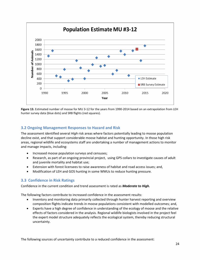
24
Figure 13. Estimated number of moose for MU 3-12 for the years from 1990-2014 based on an extrapolation from LEH hunter survey data (blue dots) and SRB flights (red squares).
3.2 Ongoing Management Responses to Hazard and Risk The assessment identified several High risk areas where factors potentially leading to moose population decline exist, and that support considerable moose habitat and hunting opportunity. In those high risk areas, regional wildlife and ecosystems staff are undertaking a number of management actions to monitor and manage impacts, including:
• Increased moose population surveys and censuses; • Research, as part of an ongoing provincial project, using GPS collars to investigate causes of adult
and juvenile mortality and habitat use; • Extension with forest licensees to raise awareness of habitat and road access issues; and, • Modification of LEH and GOS hunting in some WMUs to reduce hunting pressure.
3.3 Confidence in Risk Ratings Confidence in the current condition and trend assessment is rated as Moderate to High. The following factors contribute to increased confidence in the assessment results:
• Inventory and monitoring data primarily collected through hunter harvest reporting and overview composition flights indicate trends in moose populations consistent with modelled outcomes; and,
• Experts have a high degree of confidence in understanding of the ecology of moose and the relative effects of factors considered in the analysis. Regional wildlife biologists involved in the project feel the expert model structure adequately reflects the ecological system, thereby reducing structural uncertainty.
The following sources of uncertainty contribute to a reduced confidence in the assessment:

25
• Uncertainty regarding how habitat quality is modelled. The current model uses a 2-class (yes/no) to define capable habitat. Significant variability in habitat quality and condition exists that can influence assessment outcomes;
• Unpredictability in human hunting behaviour. The model assumes regulated, non-regulated and illegal hunting pressure is constant and consistent across all areas. In using the road density indicator, the model considers all roads have equal hunter use and hunting pressure regardless of road condition or status (open, de-activated, closed/gated) or proximity to population centres. Consistent information is not currently available to reasonable capture differences in road use or hunting pressure; and,
• Uncertainty in how well the early seral indicator used in the expert model is adequately reflected in calculation of habitat and hunting hazard. Currently, the early seral indicator is calculated as the percent early seral forest across all capable habitats. MPB salvage harvesting has been concentrated in lodgepole-pine dominated stands that are often associated with higher capability moose winter range habitats and proximity to important foraging areas (e.g. wetland complexes). Higher habitat-related hazard levels may be higher than currently estimated if:
1. Salvage harvesting has been concentrated on limited moderate to high capable winter habitats;
2. Extensive harvesting limits the availability of thermal habitats adjacent to foraging habitat; and,
3. Harvesting and open road networks are concentrated near important wetland complexes where moose congregate.

26
4. Next Steps The current assessment procedure provides a useful first approximation for evaluating the risk of lost hunting opportunities due to moose population declines. However, during the analysis and subsequent reporting, several areas have been identified to improve the assessment procedure to reduce uncertainties associated with indicators, data sources and expert-based model structure. The assessment can also be improved by more clearly defining estimates of hazard, consequence and risk using quantifiable measures for both target moose population densities (e.g. moose\km2) and hunting opportunities (e.g. hunter days by WMU). As part of next steps to improve the assessment procedure and complete an updated current condition assessment, work is currently underway in the Thompson-Okanagan region in the following areas: Refining Winter Habitat Capability
• Current habitat capability mapping utilizes a two-class (yes/no) system given limitations and differences of expert-derived ratings that vary across the region. Current work is underway to develop a consistent and repeatable empirically-derived approach to estimating habitat capability that considers climatic envelope and forage availability. The revised approach can accommodate climate-related effects on factors (winter temperature and snow depth) that affect moose distribution and abundance.
Refining Habitat Suitability • A key uncertainty recognized in the existing assessment is the effect of forest harvesting on the
adjacency of thermal/security cover and forage. An updated assessment procedure will incorporate improved methods developed in the Cariboo Region to account for habitat-related effects associated with extensive cutover areas.
Providing Population estimates
• The current assessment procedure does not provide estimates of potential moose densities based on habitat capability and expected moose density. The current procedure provides a relative estimate of change (i.e. declining, stable, and increasing) without an absolute estimate of the difference between expected and potential moose density. Absolute estimates of expected moose density will be needed to assist with quantitative targets for moose densities and hunting opportunities (see clarifying risk benchmarks section below). Work is currently underway in the Thompson-Okanagan Region to develop an empirical model that captures both habitat and population effects on the population and will be provided in the future.
Clarifying Risk Benchmarks
• The current assessment procedure defines risk as loss of hunting opportunities without clearly quantifying the extent of loss and how that compares to desired levels. Work is currently underway to define quantitative targets for levels of hunting opportunities (i.e. First Nations harvest, Guide-outfitting, LEH opportunities, GOS hunter days/kills) that can be sustained based on habitat potential. Improved information is needed to better understand First Nations use and requirements.

27
5. References Cited B.C. Ministry of Environment, Lands and Parks. 2000. Moose in British Columbia. Ecology, Conservation and
Management. http://www.env.gov.bc.ca/wld/documents/moose.pdf B.C. Ministry of Forests, Lands and Natural Resource Operations. 2013. Draft Provincial Framework for
Moose Management in British Columbia. Fish, Wildlife and habitat Management Branch, Victoria, B.C., 44 pages. http://www.env.gov.bc.ca/fw/wildlife/management-issues/
Canadian Standards Association, 1997. Risk Management Guidelines for Decision-Makers. CAN/CSA-Q850-97.54 pages.
Darimont, C.T., Paquet, P.C., Reimchen, T.E., and V. Crichton. 2005. Range expansion by moose into coastal temperate rainforests of British Columbia. Diversity and Distributions 11: 235-239.
Intergovernmental Panel on Climate Change, 2010. Guidance Notes for Lead Authors of the Fifth IPCC Assessment Report on Addressing Uncertainties. http://www.ipcc.ch/publications_and_data/publications_and_data_supporting_material.shtml
Renecker, L.A., and R.J. Hudson. 1986. Seasonal energy expenditures and thermoregulatory responses of moose. Canadian Journal of Zoology 64:322-327.
Serrouya, R.S., and K. Poole. 2007. Moose population monitoring in the Lake Revelstoke (management Units 4-38 and 4-39) and North Thompson(Mus 3-43 and 3-44) valleys, January 2006 and 2007. Unpublished technical report, 25 pages.
Vandine D., G. Moore, M. Wise, C. Vanbuskirk, and R. Gerath. 2004. Technical terms and methods. Chapter 3, Pages 13-26, IN Wise, M. P., G.D. Moore, and D.F. Vandine (editors). 2004. Landslide risk case studies in forest development planning and operations. B.C. Min. For., Res. Br., Victoria, B.C. Land Manage. Handb. No. 56. http://www.for.gov.bc.ca/hfd/pubs/Docs?Lmn?Lmh56.htm
Wilson, S. F. 2014. Thompson Moose Assessment Model. Unpublished technical report. 11 Pages.
Wise, M., G. Moore, and D. Vandine. 2004. Definition of terms and framework for landslide risk management. Chapter 2, Pages 5-12 IN Wise, M. P., G.D. Moore, and D.F. Vandine (editors). 2004. Landslide risk case studies in forest development planning and operations. B.C. Min. For., Res. Br., Victoria, B.C. Land Manage. Handb. No. 56. http://www.for.gov.bc.ca/hfd/pubs/Docs?Lmn?Lmh56.htm
28
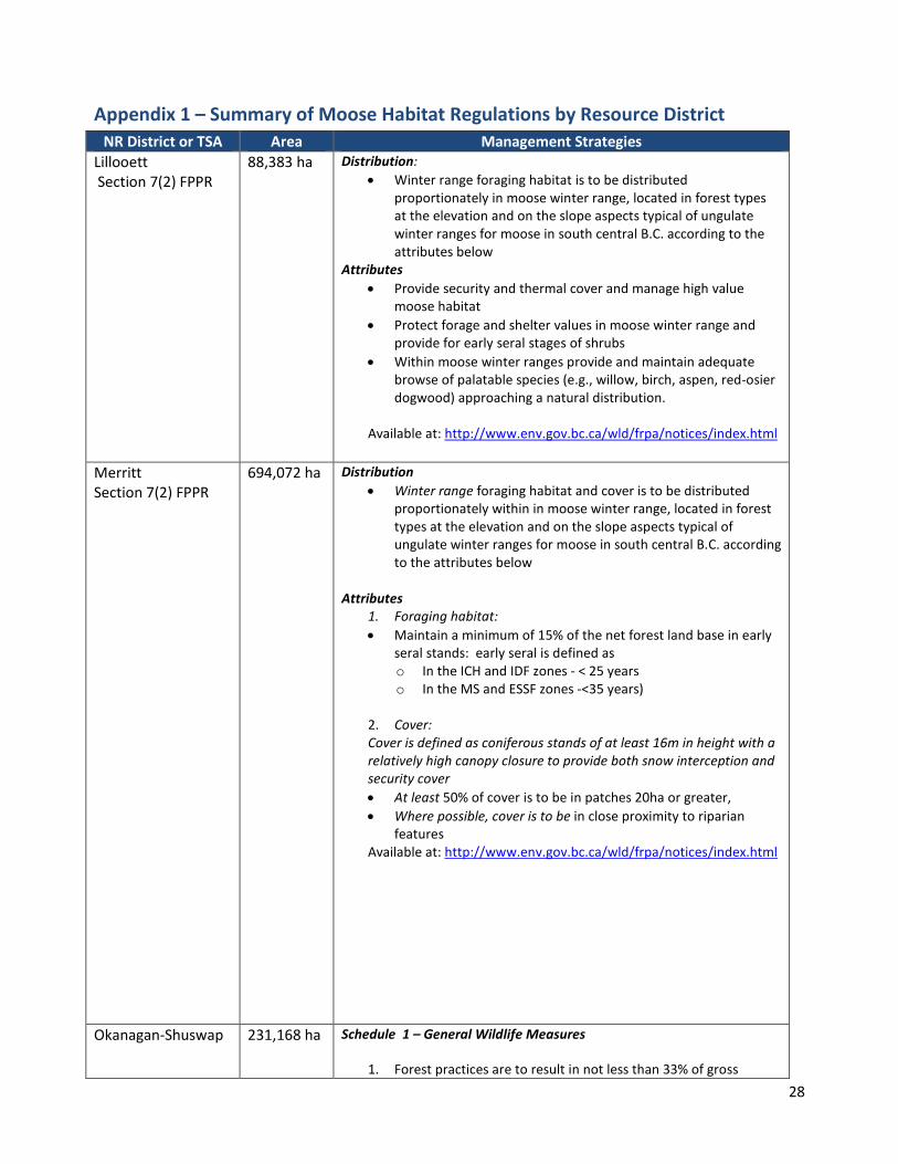
Appendix 1 – Summary of Moose Habitat Regulations by Resource District NR District or TSA Area Management Strategies
Lillooett Section 7(2) FPPR
88,383 ha Distribution: • Winter range foraging habitat is to be distributed
proportionately in moose winter range, located in forest types at the elevation and on the slope aspects typical of ungulate winter ranges for moose in south central B.C. according to the attributes below
Attributes • Provide security and thermal cover and manage high value
moose habitat • Protect forage and shelter values in moose winter range and
provide for early seral stages of shrubs • Within moose winter ranges provide and maintain adequate
browse of palatable species (e.g., willow, birch, aspen, red-osier dogwood) approaching a natural distribution.
Available at: http://www.env.gov.bc.ca/wld/frpa/notices/index.html
Merritt Section 7(2) FPPR
694,072 ha Distribution • Winter range foraging habitat and cover is to be distributed
proportionately within in moose winter range, located in forest types at the elevation and on the slope aspects typical of ungulate winter ranges for moose in south central B.C. according to the attributes below
Attributes 1. Foraging habitat: • Maintain a minimum of 15% of the net forest land base in early
seral stands: early seral is defined as o In the ICH and IDF zones - < 25 years o In the MS and ESSF zones -<35 years)
2. Cover: Cover is defined as coniferous stands of at least 16m in height with a relatively high canopy closure to provide both snow interception and security cover • At least 50% of cover is to be in patches 20ha or greater, • Where possible, cover is to be in close proximity to riparian
features Available at: http://www.env.gov.bc.ca/wld/frpa/notices/index.html
Okanagan-Shuswap 231,168 ha Schedule 1 – General Wildlife Measures
1. Forest practices are to result in not less than 33% of gross
29
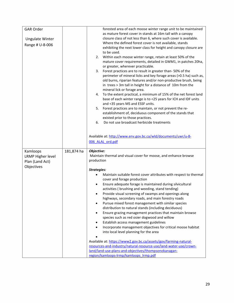
GAR Order
Ungulate Winter Range # U-8-006
forested area of each moose winter range unit to be maintained as mature forest cover in stands at 16m tall with a canopy closure class of not less than 6, where such cover is available. Where the defined forest cover is not available, stands exhibiting the next lower class for height and canopy closure are to be used.
2. Within each moose winter range, retain at least 50% of the mature cover requirements, detailed in GWM1, in patches 20ha, or greater, wherever practicable.
3. Forest practices are to result in greater than- 50% of the perimeter of mineral licks and key forage areas (>0.5 ha) such as, old burns, riparian features and/or non-productive brush, being in trees > 3m tall in height for a distance of 10m from the mineral lick or forage area.
4. To the extent practical, a minimum of 15% of the net forest land base of each winter range is to <25 years for ICH and IDF units and <35 years MS and ESSF units.
5. Forest practices are to maintain, or not prevent the re-establishment of, deciduous component of the stands that existed prior to those practices.
6. Do not use broadcast herbicide treatments
Available at: http://www.env.gov.bc.ca/wld/documents/uwr/u-8-006_ALAL_ord.pdf
Kamloops LRMP Higher level Plan (Land Act) Objectives
181,874 ha Objective: Maintain thermal and visual cover for moose, and enhance browse production Strategies:
• Maintain suitable forest cover attributes with respect to thermal cover and forage production
• Ensure adequate forage is maintained during silvicultural activities ( brushing and weeding, stand tending)
• Provide visual screening of swamps and openings along highways, secondary roads, and main forestry roads
• Pursue mixed forest management with similar species distribution to natural stands (including deciduous)
• Ensure grazing management practices that maintain browse species such as red osier dogwood and willow
• Establish access management guidelines • Incorporate management objectives for critical moose habitat
into local level planning for the area •
Available at: https://www2.gov.bc.ca/assets/gov/farming-natural-resources-and-industry/natural-resource-use/land-water-use/crown-land/land-use-plans-and-objectives/thompsonokanagan-region/kamloops-lrmp/kamloops_lrmp.pdf

30
Appendix 2 – Structure of Expert Based Bayesian Belief Model
Illus
trat
ion
of th
e Ba
yesia
n Be
lief N
etw
ork
(BBN
) exp
ert-
judg
emen
t-ba
sed
Moo
se P
opul
atio
n Ha
zard
Mod
el f
rom
Wils
on (2
014)
.

31
Appendix 3 – Description of GIS Indicators used as inputs to the Expert Model Indicator
Metric Description and Assumptions Data Source and calculation
Percent early seral 0-3m tall
Proportion of total capable winter range area in a planning cell that is covered by young forest 0-3m tall. Used in several ways in the model to represent:
1. area of potential foraging habitat created in disturbed forests
2. area of potential thermal cover that is unavailable
3. Relative vulnerability of moose to hunting assuming less visual cover and open road networks
4. Relative vulnerability to predation assuming increased predator efficiency with less visual cover and road accessibility
“Capable winter Range” is defined by combining 3 expert derived winter range mapping layers from the Thompson-Okanagan Region:
1. Okanagan winter range (Gyug, 2007) 4-class system modified from provincial BEI rating – includes Okanagan and part of Merritt TSA (old MoE region 8)
2. Southern Interior Moose Winter Range ( Lemke, 2003) Kamloops and portion of Merritt TSA
3. Lillooet TSA (Jury, 2014) 2-class system using updated linework from the Lillooett TSA moose winter range polygons
• These 3 layers were combined to define a
two-class system (yes/no) for the whole region.
• VRI RESULTS layer used to identify forested
stands with trees 0-3m tall
• Calculation = area (ha) early seral 0-3 m tall/area (ha)of forested capable winter range in moose planning cell
Percent early seral 3-6m
Proportion of total capable winter range area in a planning cell that is covered by young forest 3-6m tall Separated from 0-3m tall to consider:
1. Re-growth of tree cover reduces foraging suitability
2. Re-growth of visual cover – reduced hunting vulnerability and predation
• VRI RESULTS layer used to identify forested stands with trees 3-6m tall
• Calculation = area (ha) early seral 0-3 m
tall/area (ha) of forested capable winter range in moose planning cell.
Grazing Pressure
Proportion total potential winter feeding habitat (wetland & riparian) that is overlapped by range tenures. This indicator is used to represent the potential for
Uses a static ‘ potential winter feeding habitat’ layer derived from:
1. Wetlands from Freshwater Atlas 2. A 10m buffer on all streams B.C. Freshwater
Atlas 3. Stands with >30% deciduous as defined in

32
livestock impacts on browse species (willows) in wetlands and riparian areas on moose winter ranges.
VRI results
• This layer is the same APPROACH AS USED BY THE CARIBOO REGION and was created by the Mark McGirr
• Uses Range tenure layer from BCGW to capture extent of existing range tenures that overlap with static winter forage areas
• Calculations= area (ha) of potential winter feeding habitat that overlaps with existing range tenures
Percent in Wetlands
Proportion of winter range area in a planning cell that is occupied by wetlands. Used to identify the contribution of ‘static’ foraging habitat to overall forage availability at the planning cell level.
• Uses static potential winter feeding habitat layer described above
• Uses capable habitat layer as described above
• Calculation – area (ha) potential winter feeding habitat/total capable winter habitat in planning cell
Terrain Differentiates capable winter range habitats as occurring in “mountainous’ or ‘plateau’ terrain. Indicator is used to reflect elevation differences in winter habitat in response to snow levels. The terrain indicator affects calculation of two nodes:
1. Wolf populations concentrate in higher densities on winter ranges in mountainous terrain.
2. Downgrades the importance of forested thermal cover in mountainous terrain as moose can utilize aspects or migrate to higher elevations in spring/summer to avoid heat stress
Uses BCGW Ecosection layer to classify the region as either:
• Mountainous = ecosections labelled mountains, highlands, range or foothills
• Plateau habitat = plateau, basin, upland or highland ( North Okanagan Only)
Moose planning cells were then classified as either mountainous or plateau based on the % of the planning cell that fell in that ecosection.
Wolf Population
Relative wolf density at the planning cell level is estimated by regional wildlife biologists
A layer was created by population each moose planning cell with an expert-derived rating of wolf density. Wolf density was rated as
• Absent – wolves not present • Low– no established packs, wolves are
present in low density • High – established packs – wolves present in
higher density
33
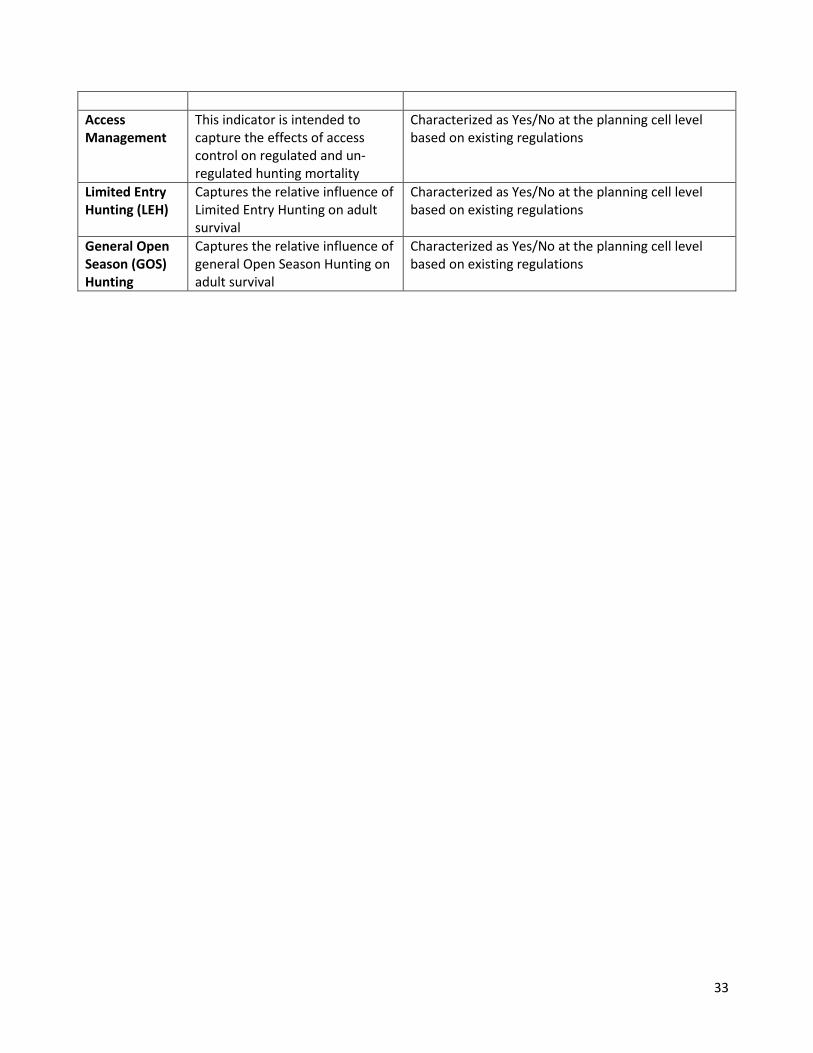
Access Management
This indicator is intended to capture the effects of access control on regulated and un-regulated hunting mortality
Characterized as Yes/No at the planning cell level based on existing regulations
Limited Entry Hunting (LEH)
Captures the relative influence of Limited Entry Hunting on adult survival
Characterized as Yes/No at the planning cell level based on existing regulations
General Open Season (GOS) Hunting
Captures the relative influence of general Open Season Hunting on adult survival
Characterized as Yes/No at the planning cell level based on existing regulations
34
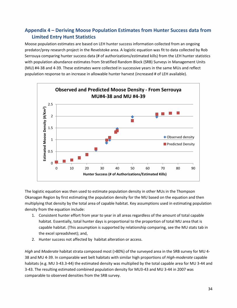
Appendix 4 – Deriving Moose Population Estimates from Hunter Success data from Limited Entry Hunt Statistics
Moose population estimates are based on LEH hunter success information collected from an ongoing predator/prey research project in the Revelstoke area. A logistic equation was fit to data collected by Rob Serrouya comparing hunter success data (# of authorizations/estimated kills) from the LEH hunter statistics with population abundance estimates from Stratified Random Block (SRB) Surveys in Management Units (MU) #4-38 and 4-39. These estimates were collected in successive years in the same MUs and reflect population response to an increase in allowable hunter harvest (increased # of LEH available).
The logistic equation was then used to estimate population density in other MUs in the Thompson Okanagan Region by first estimating the population density for the MU based on the equation and then multiplying that density by the total area of capable habitat. Key assumptions used in estimating population density from the equation include:
1. Consistent hunter effort from year to year in all areas regardless of the amount of total capable habitat. Essentially, total hunter days is proportional to the proportion of total MU area that is capable habitat. (This assumption is supported by relationship comparing, see the MU stats tab in the excel spreadsheet); and,
2. Hunter success not affected by habitat alteration or access. High and Moderate habitat strata composed most (>80%) of the surveyed area in the SRB survey for MU 4-38 and MU 4-39. In comparable wet belt habitats with similar high proportions of High-moderate capable habitats (e.g. MU 3-43.3-44) the estimated density was multiplied by the total capable area for MU 3-44 and 3-43. The resulting estimated combined population density for MU3-43 and MU 3-44 in 2007 was comparable to observed densities from the SRB survey.
0
0.5
1
1.5
2
2.5
0 10 20 30 40 50 60 70 80 90
Estim
ated
Moo
se D
ensi
ty (#
/Km
2 )
Hunter Success (# of Authorizations/Estimated Kills)
Observed and Predicted Moose Density - From Serrouya MU#4-38 and MU #4-39
Observed density
Predicted Density

35
On drier plateau habitats (e.g. ESSF dc2, MSdm3) (e.g. MU 3-30, 3-29), SRB survey estimates identify significantly greater amounts of Low suitable habitat strata (e.g. Lemke, 2013). For example, total area of Low strata composed approximately 50% and 80% of MU 3-30B and MU 3-29 respectively. Observed densities on Low habitat strata were approximately 50% and 20% of observed moose densities on High and Moderate habitat strata for MU 3-30B and MU 3-29 respectively (Lemke, 2007). Thus, to estimate moose densities in other MUs where SRB data is unavailable, density estimates from the equation were multiplied by a habitat modifier to account for lower observed densities on Low habitat strata. The modified density was then multiplied by the proportion of total capable habitat as Low or Moderate-High habitat. For example, 50% of the capable area in MU 330-B was multiplied by a modifier of 0.5, whereas 80% of the area in MU 3-29 was multiplied by a modifier of 0.2. The resulting estimated population abundance for MU 330-B and MU 3-29 closely matched the observed estimates from the 2013 SRB survey (Lemke, 2013). For all other MUs, the amount of low quality habitat strata in each MU was estimated from available SRB surveys or older habitat capability modelling that incorporated 4 or 6 classes.

36
Appendix 5 – Merritt TSA Hazard and Risk Ratings Table
Moose Population Hazard and Risk - Merritt TSA 2003 - 2014 Planning
Cell % Early Seral
(0-3m) Habitat Hazard
Predation Hazard
Hunting Hazard Cons. Moose Risk
2003 2014 2003 2014 2003 2014 2003 2014 2003 2014 Asp Creek 8.6 18.2 L L L L L L MOD LOW LOW Crater Mtn. 1.6 14.3 L L L L L L LOW LOW LOW Dardanelles 12.1 33.6 L M L L L M HIGH MOD HIGH Douglas Lake 6.7 8.3 L L L L L L HIGH MOD MOD Frogmore 10.1 28 L L L L L L HIGH MOD MOD Maka 4.4 4.6 L L L L L L LOW LOW LOW McNulty 17.1 27.2 L L L L L L MOD LOW LOW Nicola 19.4 33.3 L M L L L M HIGH MOD HIGH Pasayten 9.6 8.8 L L L L L L LOW LOW LOW Pennask 9.5 30.5 L M L L L M HIGH MOD HIGH Pimanus 9 29.7 L L L L L L HIGH MOD MOD Prospect 1.9 4.4 L L L L L L LOW LOW LOW Quilchena 5.7 16.1 L L L L L L HIGH MOD MOD Rey 5.1 18.9 L L L L L L HIGH MOD MOD Siwash 12.3 28.9 L L L L L L HIGH MOD MOD Skuhun 9.9 27.9 L L L L L L HIGH MOD MOD Summers 12.8 26.6 L L L L L L MOD LOW LOW Thynne 8.4 10.3 L L L M L L LOW LOW LOW Tulameen 2.8 4.5 L L L L L L LOW LOW LOW Voght 3.5 12.5 L L L L L L MOD LOW LOW Whipsaw 24.8 14.0 L L M M L L LOW LOW LOW Willis 17.1 18.2 L L L L L L LOW LOW LOW
LOW LOW LOW LOW LOW LOW OVERALL RATING LOW MOD

37
Appendix 6 – Lillooet Hazard and Risk Ratings Table
Moose Population Hazard and Risk - Lillooet TSA 2003 - 2014 Planning
Cell % Early Seral
(0-3m) Habitat Hazard
Predation Hazard
Hunting Hazard Cons. Moose Risk
2003 2014 2003 2014 2003 2014 2003 2014 2003 2014 Botanie 15.0 L L L L L L LOW LOW LOW Camelsfoot 16.5 8.2 L L L M L L LOW LOW LOW Carpenter S. 16.8 10.3 L L L M L L LOW LOW LOW Cayoosh East N/A N/A Cayoosh West N/A N/A Downton 35.1 9.9 L L L L L L LOW LOW LOW Fountain Lake 21.2 8.2 L L L M L L LOW LOW LOW Gun 9.9 6.0 L L L M L L LOW LOW LOW Mohokam N/A N/A Nahatlatch N/A N/A Nicoamen 9.9 6.2 L L L L L L LOW LOW LOW Shulaps 21.7 18.1 L L M M M M LOW LOW LOW
LOW LOW LOW MOD LOW LOW OVERALL RATING LOW LOW

38
Appendix 7 – Clearwater Hazard and Risk Ratings Table
Moose Population Hazard and Risk - Kamloops TSA- North 2003 - 2014 Planning
Cell % Early Seral
(0-3m) Habitat Hazard
Predation Hazard
Hunting Hazard Cons. Moose Risk
2003 2014 2003 2014 2003 2014 2003 2014 2003 2014 Adolph L L M H L L LOW LOW MOD Lempriere L L M H L L LOW LOW MOD Bone L L M H L L LOW LOW MOD Wells Gray W. L L M H L L LOW LOW MOD Wells Gray E. L L M H L L LOW LOW MOD North Blue L L M H L L LOW LOW MOD Berry L L M H L L LOW LOW MOD Finn L L M H L L LOW LOW MOD Upper Adams L L M H L L LOW LOW MOD Raft L L M H L L LOW LOW MOD Mad River M L M H L L LOW LOW MOD Swayback L L M H L L MOD MOD HIGH Otter L L M H L L LOW LOW MOD Lower Adams L L M H L L LOW LOW MOD Dunn L L L H L L LOW LOW MOD Cayenne L L M H L L LOW LOW MOD Nehalliston M M L M L L MOD LOW MOD Darlington M M L M L L MOD LOW MOD E. Barriere M L M H L L LOW MOD MOD Pukeashun L L M H L L LOW MOD MOD
LOW LOW MOD HIGH LOW LOW OVERALL RATING LOW MOD

39
Appendix 8 – Kamloops Hazard and Risk Ratings Table
Moose Population Hazard and Risk - Kamloops 2003 - 2014 Planning
Cell % Early Seral
(0-3m) Habitat Hazard
Predation Hazard
Hunting Hazard Cons. Moose Risk
2003 2014 2003 2014 2003 2014 2003 2014 2003 2014 Bonaparte N. M M L M L M HIGH MOD HIGH Darfield M M L M L M MOD LOW MOD Chu Chua M M L M L M MOD LOW MOD Barriere M M L M L L MOD LOW MOD Bonaparte S. L M L M L L HIGH MOD HIGH Tsintsunko M M L M L L HIGH MOD HIGH Skull M H M M L M MOD MOD MOD Sullivan Lake H H M M M M MOD MOD MOD Cahilty M M L M L L MOD LOW MOD Pisima Mtn. L L L H L L LOW LOW MOD Criss Creek M M L M L L HIGH MOD HIGH Tranquille N. M M L M L L HIGH MOD HIGH Tranquille S. M L L M L L HIGH MOD HIGH Paul L M L M L L HIGH MOD HIGH Niskonlith M M L M L L LOW LOW LOW Pavillion L M L M L L LOW LOW LOW Arrowstone L M L M L L MOD LOW MOD Blue Earth L M L M L L LOW LOW LOW Cornwall Hills L L L M L L LOW LOW LOW Glossy Mtn. L M L L L L HIGH MOD MOD Pimanus L M L L L L HIGH MOD MOD Guichon L M L L L L HIGH MOD MOD Greenstone M M L L L L HIGH MOD MOD Rey L M L L L L HIGH MOD MOD Frogmore L M L L L L HIGH MOD MOD Lac le Jeune L M L L L L HIGH MOD MOD Dardanelles M L M HIGH MOD HIGH Campbell M M L L L L HIGH MOD MOD Paxton valley L M L M L M HIGH MOD HIGH
MOD MOD LOW MOD LOW LOW OVERALL RISK RATING LOW MOD

40
Appendix 9 – Okanagan North Hazard and Risk Ratings Table
Moose Population Hazard and Risk – Okanagan TSA- North 2003 - 2014 Planning
Cell % Early Seral
(0-3m) Habitat Hazard
Predation Hazard
Hunting Hazard Cons. Moose Risk
2003 2014 2003 2014 2003 2014 2003 2014 2003 2014 Anstey 8.2 4.9 L L M H L L LOW LOW MOD Armstrong 8.9 6.5 L L L L L L LOW LOW LOW Ashton 16.8 14.2 M M M M L L LOW LOW LOW Deep Creek 21.8 16.2 M M L M L L LOW LOW LOW Fly Hills 29.3 22.8 M M L M L L MOD LOW MOD Grinrod 19.4 12.7 M L L M L L LOW LOW LOW Ireland 10.4 7.2 L L L M L L LOW LOW LOW Mount Mobley 15.1 9.6 L L M H L L LOW LOW MOD Perry 13.3 10.1 L L H H L L LOW MOD MOD Seymour 17.9 10.9 L L H H L L LOW MOD MOD Trinity 16.3 11 L L M M L L LOW LOW LOW Up. Shuswap 9.7 7.5 L L L M L L LOW LOW LOW Wap 10.2 5.6 L L L M L L LOW LOW LOW White Lake 13.9 10.1 L L H H L L LOW MOD MOD Yard 15.1 12 L L M M L L LOW LOW LOW
LOW LOW MOD MOD LOW LOW OVERALL RATING LOW LOW

41
Appendix 10 – Okanagan South Hazard and Risk Ratings Table
Moose Population Hazard and Risk – Okanagan TSA- South 2003 - 2014 Planning
Cell % Early Seral
(0-3m) Habitat Hazard
Predation Hazard
Hunting Hazard Cons. Moose Risk
2003 2014 2003 2014 2003 2014 2003 2014 2003 2014 Apex 6.6 6 L L L L L L LOW LOW LOW Beak 43 32 M M L L L M HIGH MOD HIGH Belgo 21 15.3 M M L M L L MOD LOW MOD Cherry 8.9 6.8 L L L M L L LOW LOW LOW Equesis 11.7 7.7 L L L L L L LOW LOW LOW Harris 18.6 13.9 M M L M L L LOW LOW LOW Hydraulic 26.2 22.4 M M L M L L MOD LOW MOD Ingram 27.1 24 M M L L L L MOD LOW MOD Isintok 13.9 11.3 M M L L L L MOD LOW MOD Oliver 8.5 5.3 L L L L L L LOW LOW LOW Peachland 13.4 9.4 L L L L L L HIGH MOD MOD Penticton 34.6 30.6 H H L L L M MOD LOW MOD Terrace Mtn. 12.9 9.9 L L L L L L MOD LOW LOW Trapping 17.6 11.1 M M L M L L LOW LOW LOW Trepanier 17.5 12.8 M M L L L L HIGH MOD MOD Up. Kettle 23.2 15.2 M M L M L L LOW LOW LOW Vaseaux 20.8 11.6 M M L L L L MOD LOW MOD Vernon 17.3 12.8 M M L L L L LOW LOW LOW Wilkinson 15.9 9.1 L L L L L L MOD LOW LOW
MOD MOD LOW LOW LOW LOW OVERALL RATING LOW MOD