
Thompson Okanagan Region Drought Response Implementation Plan€¦ · Thompson Okanagan Region ....
34
i Thompson Okanagan Region Drought Response Implementation Plan Thompson Okanagan Drought Response Team Revised July 2016
Transcript of Thompson Okanagan Region Drought Response Implementation Plan€¦ · Thompson Okanagan Region ....

i
Thompson Okanagan Region Drought Response
Implementation Plan Thompson Okanagan Drought Response Team
Revised July 2016

ii
Table of Contents 1 Introduction ............................................................................................................................. 1
2 Objectives of the plan .............................................................................................................. 1
3 Area of the plan ....................................................................................................................... 1
4 Drought Management Team ................................................................................................... 2
Thompson Okanagan Regional Management Team ........................................................ 2 4.1
The Thompson Okanagan Drought Response Team ........................................................ 2 4.2
5 Roles and Responsibilities ....................................................................................................... 3
Incident command Structure ........................................................................................... 5 5.1
6 Drought Assessment and Response ........................................................................................ 7
Stream Watch List ............................................................................................................ 7 6.1
Sensitive Aquifer List ........................................................................................................ 7 6.2
Pre- Season Indicators ...................................................................................................... 8 6.3
7 Data Management ................................................................................................................. 13
Data Management ......................................................................................................... 13 7.1
Current Stream Condition Report .................................................................................. 14 7.2
8 Communication ..................................................................................................................... 15
Key Messaging ................................................................................................................ 15 8.1
Communication Roles and Responsibilities ................................................................... 15 8.2
9 Training .................................................................................................................................. 20
APPENDICES .................................................................................................................................. 22
Appendix 1. Definitions ....................................................................................................... 22
Appendix 2. Additional information required for watch list streams ................................ 23
Appendix 3. 2015 Regional Drought Response Team ........................................................ 24
Appendix 4. Flow chart showing the drought assessment and response process ............. 25
Appendix 5. Relevant Legislation – Flow Regulation .......................................................... 26
Appendix 6. Example Current Stream Conditions Report (CSCR) ....................................... 29
Appendix 7. Regional Stream Watch List ............................................................................ 30

1
1 Introduction Drought is a recurrent feature of climate involving a deficiency of precipitation over an extended period of time, resulting in a water shortage for activities, communities or aquatic ecosystems. Low stream flows can also have impacts on groundwater levels. Aquifers can be impacted in a given drought year and following previous drought seasons, as there may not be enough water to allow for recharging. Many streams in the Thompson-Okanagan region are flow sensitive in the summer period and may commonly be in a drought state, particularly when subject to withdrawal. Lower stream flows reduce aquatic habitat, affect fish migration and spawning and may cause warmer river temperatures, which impacts fish and other aquatic life. It can also affect the growth of agricultural crops and limit the water available for irrigation. During times of scarcity, conflicts relating to water use include those between licenced users and also those that arise from insufficient water to meet the combined licenced demand and environmental needs. To appropriately address and reduce drought-related impacts, it is imperative for water managers to anticipate, plan and mitigate for drought. This document was developed by the Ministry of Forest, Lands and Natural Resource Operations, Thompson Okanagan Region (TOR) to help managers assess and respond to worsening drought conditions. This plan focuses on drought response - the actions taken before, during and immediately following a drought to reduce its impacts. The plan outlines a proactive approach to water management during times of water scarcity and is complimentary to the Provincial Drought Response Plan (2015).
2 Objectives of the plan The primary objectives of this plan are:
• to provide guidance to FLNR to effectively prepare for drought any given year • to accurately assess and effectively respond to changing drought conditions • to minimize the effect of drought on both aquatic ecosystems and water users • to develop strong communication links with licensees, First Nations and key
stakeholders
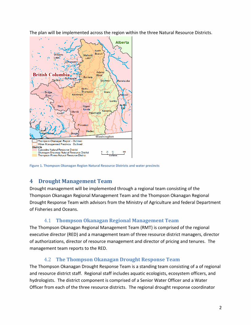
3 Area of the plan This Drought Response Implementation Plan applies throughout the FLNRO Thompson-Okanagan Region (Figure 1) and within specific water precincts that occur within the Cariboo and the Kootenay Boundary region that are administered by the Thompson Okanagan Region.
2
The plan will be implemented across the region within the three Natural Resource Districts.
Figure 1. Thompson Okanagan Region Natural Resource Districts and water precincts
4 Drought Management Team Drought management will be implemented through a regional team consisting of the Thompson Okanagan Regional Management Team and the Thompson Okanagan Regional Drought Response Team with advisors from the Ministry of Agriculture and federal Department of Fisheries and Oceans.
Thompson Okanagan Regional Management Team 4.1The Thompson Okanagan Regional Management Team (RMT) is comprised of the regional executive director (RED) and a management team of three resource district managers, director of authorizations, director of resource management and director of pricing and tenures. The management team reports to the RED.
The Thompson Okanagan Drought Response Team 4.2The Thompson Okanagan Drought Response Team is a standing team consisting of a of regional and resource district staff. Regional staff includes aquatic ecologists, ecosystem officers, and hydrologists. The district component is comprised of a Senior Water Officer and a Water Officer from each of the three resource districts. The regional drought response coordinator

3
(DRC) is the team lead. Technical advisors from the BC Ministry of Agriculture and from the Federal Department of Fisheries and Oceans will be invited to participate on the drought response team. The core team membership will be determined each spring (May 1) so team members can prepare for the summer drought season. A sample of a typical drought response team is shown in Appendix 3. The drought response team will address priority actions across the entire region. Given that drought conditions may develop unequally across the region, drought response team members are not restricted by district boundaries. Throughout the drought season and depending on drought severity, it is likely that other people including additional regional operational staff, FN advisors, provincial policy advisors and GCPE communication specialists will be added to the response team.
5 Roles and Responsibilities Each member of the team has a set role with different responsibilities that contribute to the main functions of collecting flow information, setting the drought level, regulating flow during times of scarcity, communication, and follow-up monitoring (Table 1).
Table 1. Drought Response Roles and Responsibilities Matrix.
Title Responsibility Regional Drought Response Coordinator
Leads regional drought response team. Coordinates drought response actions between team members. Liaise with Thompson Okanagan Regional Management Team. Primary point of contact for regional drought related questions. Primary contact for media communication. Primary liaise with Provincial Technical Drought Working Group and River Forecast Center. Coordinates regional drought training. Coordinates drought response contracts .
Regional Drought Specialists: Surface Water Hydrologists Aquatic Ecologists Groundwater Hydrologists Hydrogeologists Fisheries Biologists
Analyze stream flow and groundwater information. Collect groundwater information. Develop monitoring plan for streams on watch list. Maintain and updates stream watch list. Implement regional angling closures. Provide guidance for stream flow measurements. Develop critical environmental flow thresholds for fish. Lead regional stream flow training. Manage stream flow data and Current Condition Reports.

4
Senior Water Officers and District Water Officers
Primary contact for district level drought related enquiries and communication with public, First Nations and water licensees. Develop first in time, first in rights (FITFIR) lists for district licensees. Implement FITFIR as required. Communicate changes in drought condition and response. actions with district manager and district water licensees. Conduct stream flow measurements.
First Nations (Drought Response Team)
Provides flow, temperature, fish and other related information to drought response team. Provides strategic and operational advice to drought. response team. Informs and updates First Nations communities on regional drought conditions and responses.
Regional Executive Director/Regional Management Team (Director of Authorizations Director of Resource Management Resource District Manager -(Okanagan Shuswap, Thompson Rivers, Cascades)
Facilitates drought management funding. Provides strategic guidance to drought management. Communicates drought updates to ADM. Chair regional stakeholder information calls/meetings. Primary contact with Minister for designating WSA section 86 and section 88 orders. Leads government to government communication with First Nations.
Resource District Resource Managers
Oversees communication with district licensees, OBWB, leads district (local) communication with GCPE and media. Oversees coordination of district staff and actions. Ensures appropriate level of drought-related training for staff.
Regional First Nation Relations Manager
Leads regional drought related First Nations communication.
District First Nations Officer Leads district First Nations consultation. Assists drought response team and district water staff with communication with First Nations on local drought level, key management actions and other drought-related matters.
Department of Fisheries and Oceans (Drought Response Team)
Strategic and operational advisor on drought related issues pertaining to salmon population and fish habitat. Provides stream specific salmon migration and spawning information to drought response team.

5
Agriculture Resource Specialist (Drought Response Team)
Strategic and operational advisor. Evaluates economic consequences of drought response actions on producers. Provides agricultural use and water demand information to drought response team. Communicate changes in drought condition and proposed response actions to agriculture community, stakeholders and licensees. Liaises with Ministry of Agriculture Minister and executive.
Compliance and Enforcement (C&E Manager, Natural Resource Officer)
Assist with delivering Water Sustainability Act Section 88 Orders and or S.87 FITFIR implementation. Address non-compliance with regulatory actions.
Legal Services advisors, Ministry of Justice and the Attorney General
Advises and assists with the development of S.88 orders.
FLNRO Water (Victoria) Advisory role, leads assignment of drought level (River Forecast Center), coordinates provincial Technical Drought Working Group, assists with implementation of WSA.
MOE Water (Victoria) Advisory role regarding all aspects of WSA related to drought( S.86 declaration of water scarcity, S.87 and S.88 orders, application of FITFIR). Provide guidance to region regarding application of FITFIR.
Provincial Government Communications and Public Engagement (GCPE)
Coordinates mass media communication for drought issues. Assists with local news releases.
Front Counter BC Communication with stakeholders applying for water licenses.
Incident command Structure 5.1If drought is widespread and worsening, an incident command structure is recommended (Figure 2). Within the Thompson Okanagan incident command structure, key decisions will be made by RMT and implemented through the DRC to the regional response team. Government Communications and Public Engagement (GCPE) will advise, assist with and influence communication. Both Water Protection and Sustainability Branch (MOE) and Water Management Branch (FLNR) are key advisory agents to the response process. The federal

6
Department of Fisheries and Oceans and the provincial Ministry of Agriculture are also key contributors to drought response. The regional Compliance and Enforcement Manager will be included to ensure familiarity with emerging issues that may require C&E involvement.
Figure 2. Drought Response Incident Command Structure.
Department of Fisheries and Oceans
Ministry of Agriculture
FLNR Compliance
and Enforcement

7
6 Drought Assessment and Response
Stream Watch List 6.1For all districts, a priority list of flow sensitive streams has been developed to guide monitoring activities during the drought season (July through September). This group of prioritized streams is the “Stream Watch List”. As geography and water management activities are specific to individual basins, the response to drought conditions will vary between streams. Water management response options appropriate to each drought level will be identified for each stream on the list.
The two main categories of streams on the Watch List include streams with Water Survey Canada (WSC) automated real-time data and streams where manual streamflow measurements will be required (Appendix 7). A set of hydrological descriptors for each stream on the list will be developed to help place the reported discharge measurement from any given date into context (Appendix 2). Streams requiring manual flow monitoring include those that have been monitored on previous drought circuits (e.g., Doyle 2004 and Nyhof 1988), those identified as having water demand levels that can pose a high risk to environmental values, reference streams, and those that have been identified by Water Officers as flow sensitive streams with high demand. For each stream requiring manual flow monitoring, the Regional Specialists will pre-determine the specific locations for measuring stream flow, water level, water temperature and fish habitat condition (e.g., riffle depth).
Sensitive Aquifer List 6.2Groundwater discharge to surface streams may comprise a high percentage of base flow, particularly in smaller streams during critical low flow periods. The use of groundwater that is hydraulically connected to surface water can affect stream flows and stream temperature, though the relationship is challenging to managers. For example, when curtailing surface water diversions during droughts, there is an immediate response in streamflow recovery. In contrast, the recovery of streamflow following stoppage of groundwater pumping is delayed and variable; streamflow may recover over a period time that can span minutes to years depending on the well location relative to the stream and the aquifer hydraulic properties. Because groundwater curtailment has variable effects on streamflow, the water manager is faced with the question of how to effectively and equitability curtail both surface and groundwater use during times of drought in accordance with section 22(1) of the WSA. It is important to have a solid science-based approach to GW curtailment since curtailment will be implemented similar to the FITFIR model used for surface water management.
To provide support for drought implementation, FLNR groundwater specialists will provide technical groundwater expertise, options for groundwater curtailment (in accordance with Section 22(1) of the WSA), support to other professionals to assess groundwater/surface water
8
interactions and recommendations for shallow groundwater monitoring in priority areas. This will require:
• Developing a sensitive aquifer list similar to the stream watch list • Monitoring shallow aquifers on a priority basis where groundwater withdrawals are
hypothesized to be impacting priority streams • Developing groundwater curtailment models for priority areas
The stream watch and aquifer watch lists will be periodically updated throughout the drought season. As part of the communication strategy, watch list updates will be shared with stakeholders and First Nations as detailed in section 7 of this plan.
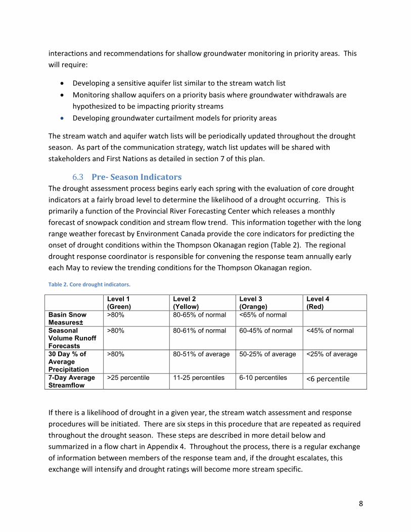
Pre- Season Indicators 6.3The drought assessment process begins early each spring with the evaluation of core drought indicators at a fairly broad level to determine the likelihood of a drought occurring. This is primarily a function of the Provincial River Forecasting Center which releases a monthly forecast of snowpack condition and stream flow trend. This information together with the long range weather forecast by Environment Canada provide the core indicators for predicting the onset of drought conditions within the Thompson Okanagan region (Table 2). The regional drought response coordinator is responsible for convening the response team annually early each May to review the trending conditions for the Thompson Okanagan region.
Table 2. Core drought indicators.
Level 1 (Green)
Level 2 (Yellow)
Level 3 (Orange)
Level 4 (Red)
Basin Snow Measures±
>80% 80-65% of normal <65% of normal
Seasonal Volume Runoff Forecasts
>80% 80-61% of normal 60-45% of normal <45% of normal
30 Day % of Average Precipitation
>80% 80-51% of average 50-25% of average <25% of average
7-Day Average Streamflow
>25 percentile 11-25 percentiles 6-10 percentiles <6 percentile
If there is a likelihood of drought in a given year, the stream watch assessment and response procedures will be initiated. There are six steps in this procedure that are repeated as required throughout the drought season. These steps are described in more detail below and summarized in a flow chart in Appendix 4. Throughout the process, there is a regular exchange of information between members of the response team and, if the drought escalates, this exchange will intensify and drought ratings will become more stream specific.
9
Step 1 –Pre-drought Preparation Prior to the onset of summer base flow conditions when drought response actions may be required, the team undertakes an annual preparation for stream monitoring. This includes establishing discharge measurement stations at the historic and active Water Survey of Canada stations of interest ( as indicated on the Stream Watch List), arranging property access, establishing stage references (e.g., staff gauges), and determining transect locations for discharge measurement. This information is essential for those people tasked with stream monitoring.
Step 2 – Evaluate Water Survey Canada Streamflow Information To evaluate drought conditions, information on stream flow from a variety of sources will be collated by the Regional Specialists. The main information source will be the Water Survey of Canada (WSC) real-time stations of interest. This verified data will be supplemented through field observations by Water Officers and through other sources. General information such as WSC data will be screened by the Regional Specialists to determine reliability. Additional information in locations of interest will be requested from the WSC. All WSC real-time data is initially published as provisional and requires screening. Depending on the screening results, field confirmation may be required. The Regional Specialists will prioritize those streams on the Watch List that will require manual streamflow monitoring.
Step 3 – Conduct Streamflow Measurements Water Officers, and other trained technicians, will manually collect streamflow information at locations pre-determined by the Regional Specialists for each priority stream. At each location, specific data will be recorded including water depth at a pre-determined reference point, discharge at a predetermined cross-section, photos, and habitat information (habitat connectivity, water temperature and riffle depth/velocity). Measurements and photos will be collected in a standard format. Streamflow monitoring will be conducted on a circuit basis. Scheduling and resourcing for operating the circuit will be determined early in the season. A field manual will be developed to describe standards for reporting stream flow levels based on ecological consequences. All data collected will be forwarded to the Regional Specialists for evaluation.
Step 4 – Evaluate Detailed Information and Assign Drought Levels The evaluation of drought condition and response requires information from three main areas including:
• Current streamflow conditions. Stream flow information for all of the Watch List streams is updated on a regular basis and entered into the Regional Drought Response Database and reported out through the Current Stream Conditions Report (CSCR). The CSCR is a matrix portraying watch list streams with essential information including most

10
recent flow measurement (WSC real time or manual), mean annual discharge (MAD), fish species present, critical rearing, migrating and spawning flow thresholds, temperature and other variables used to inform management decisions by the drought response team.
• Critical flow thresholds for fish - Critical flows are determined through a rigorous science-based process and designated for each stream. Critical flow thresholds and timing of flows are provided for rearing, migration and spawning life stages specific to the species of fish present. These thresholds are based on the best available information and are available for all streams on the Watch List.
• Irrigation demand. This includes water that is diverted from both streams and aquifers that are hydraulically connected to the streams and upstream of the point of interest. Monthly water demand estimates are included in reports for 11 drought prone watersheds in the region.
During drought, snow pack and stream flow forecasts are updated bi-weekly by the RFC. This information along with regional weather trends provided by Environment Canada is jointly evaluated by the regional response team, provincial water specialists and the River Forecast Center to collaboratively set regional, watershed, and/or sub-basin drought level. This process is consistent with that outlined in the 2016 Provincial Drought Response Plan. For the late June to October season, at Level 1 (Green), conditions are normal and there is sufficient water to support ecosystem and water uses. Emphasis is on preparedness and taking action in advance of droughts in order to increase readiness of water users and communities when they inevitably occur.
At Level 2 (Yellow), conditions are dry and the first indications of potential water supply shortages are recognized. Management emphasis is on water stewardship and voluntary conservation through education, communication and planning.
At Level 3 (Orange), conditions are becoming very dry. Potentially serious ecosystem or socio-economic impacts are possible or imminent and impacts may already be occurring. Emphasis continues to be on voluntary conservation but increasing use of watering restrictions may be imposed by water service providers. At Level 4 (Red), conditions are extremely dry and there is insufficient supply to meet community or ecosystem needs. Non-regulatory measures will continue but may be augmented by regulatory requirements including use of authorities provided under the Water Sustainability Act.
Table 3. Criteria for assigning drought level (from the Provincial Drought Response Plan, 2015).
Drought Level Flow Conditions

11
Level 1 – Green Greater than > 25th percentile Level 2 – Yellow 11 – 25th percentile Level 3 – Orange 6 – 10th percentile Level 4 – Red < 6th percentile
Ongoing streamflow information is summarized by Regional Specialists and presented in the Current Stream Conditions Report (CSCR – see Appendix 6). The CSCR will be updated increasingly more frequent as drought escalates. For Drought Level 3 the CSCR will be updated weekly. At Drought Level 4, the CSCR will be updated twice each week. The method for preparing the CSCR is described in Section 6 – Data Management.
Note that while drought management is important during other times of the year, especially for reservoir management (filling and releasing), actions arising from the implementation of this plan are only intended to be applied during the period of summer base flow, approximately defined as the period of lowest monthly flows during the summer irrigation season (July – September) for each year, on average (see Appendix 1 for complete definition and example).
Step 5 – Apply Measures to Address Streamflow Conditions As drought conditions escalate, response measures will follow a continuum, intensifying as conditions worsen (see flow chart in Appendix 4). Response measures to reduce water use may be regulatory or non-regulatory. Consistent with the Provincial response protocol, the regional response measures will focus on non-regulatory (voluntary) reduction from Level 1 through Level 3. In general, by Drought Level 4, management actions to reduce water use will become more regulatory in nature. The approach used, whether voluntary or regulatory, should consider risk to the fisheries resource, the level of engagement with the water user community and reasonable likelihood of meeting the reduction levels targeted.
The Thompson Okanagan Drought Response Team will provide recommendations for the Drought Level Rating for each of the seven major drainage basins in the study area (e.g., Similkameen, Okanagan, Kettle, Nicola, North Thompson, South Thompson and Middle Fraser). There are two reasons why management will become more stream specific as drought conditions:
(1) the natural water supply and water demand can be highly variable for sub-basins within these major watersheds; and
(2) numerous sub-basins in the region have storage systems specifically designed to provide secure water sources for downstream users and healthy environmental flows during dry periods. Storage systems could include surface water reservoirs or aquifers.

12
The Province will work with licensees in storage-based systems to set environmental flow targets. As the drought level escalates, sub-basins with storage-based systems that meet these targets would not be subject to water-use restrictions. In situations where the water-use restrictions are different between sub-basins, user-specific communication will be an important component of the drought response. Ideally, sub-basin specific flow targets and communication plans would be completed in advance of any water shortage. The Province will work with licensees, purveyors and bailiffs towards this goal of achieving optimal drought resiliency at the sub-basin scale.
Regulatory tools include enforcing fish clauses within water licenses, applying first in title, first in rights (FITFIR) or implementing Sections 86, 87 or 88 of the Water Sustainability Act (Appendix 4).
The Regional Drought Response Coordinator will provide assessment results and the recommended response to the Regional Management Team for their guidance.
As conditions worsen, drought information will also be shared with Federal and Provincial fisheries managers to allow them to implement regulatory actions such as fishing closures to address drought related concerns (e.g., fish stranding, heat stress).
Non-regulatory (Voluntary) Request to Reduce Water Use Where the regional response team and RMT determine that water use should be reduced in a given area, surface water and connected groundwater users will be requested to reduce use as a first approach for ensuring critical environment flows are met (Drought Level 2 and Drought Level 3). Non-regulatory efforts will be most successful where the users have some level of organization for more efficient communication and implementation of reduction measures. Surface flow and aquifer monitoring will be conducted concurrent with voluntary requests to track the effectiveness of the process.
Regulated Reductions in Water Use in Response to Drought Regulatory actions will be considered where voluntary actions are less likely to be successful and the risk to the aquatic resource is high. The process for a regulatory response is through Sections 86, 87 and 88 of the Water Sustainability Act, summarized here:
Under Section 86, the Minister of Forests Lands and Natural Resource Operations or the Lieutenant Governor may declare an area of significant water shortage. Usually this will apply on a temporary basis, up to 90 days (the Lieutenant Governor order may be longer).
Under Section 87, when an area of water shortage is declared, the Water Comptroller designates critical environmental flow thresholds for streams within the geographical

13
area and water reduction is implemented through FITFIR, both for surface and groundwater users. The application of FITFIR provides maximum flexibility for managers to respond to changing drought and flow conditions.
Under Section 88, whether there is a declared water shortage or not, the Minister of Forests, Lands and Natural Resource Operations may order water licensees on a specified stream to reduce water use regardless of their licence precedence (FITFIR does not apply).
This legislation is presented in Appendix 5.
Step 6 – Monitor Regulatory Compliance and Effectiveness For each regulatory restriction, the Regional Specialists will develop a stream specific plan to monitor streamflow. District Water Officers will implement these plans, monitor compliance with the regulatory restrictions, and evaluate to what degree the restrictions are improving stream flow. The Water Officers will work cooperatively with the Regional Specialists to determine when restrictions can be lifted.
Compliance and Enforcement during Drought
Natural Resource Officers (NROs) with Compliance and Enforcement Branch (CEB) of FLNRO will provide support to the drought response team during drought response conditions. NROs may assist in the delivery of orders and their presence may promote compliance with the prescribed order and serve as an ideal platform for future enforcement response under the Water Sustainability Act (WSA) where necessary. The CEB will lead the enforcement response with orders that have not been complied with. Although not responsible for monitoring water use, any significant water use related non-compliances discovered in the field by NROs will be brought to the attention of the Regional Drought Response Team.
Communications with the CEB Regional Manager will occur early in the season (May – June) to help set CEB staff schedules and determine the protocol for providing CEB assistance. In addition, the CEB Regional Manager will be part of the incident command structure to ensure CEB awareness of emerging issues. The Regional Manager will be the point of contact for enforcement requests. In situations where officer safety issues are present, NROs may request assistance from the Conservation Officer Service (COS) or RCMP.
7 Data Management
Data Management 7.1Managing stream flow data during the middle of a drought is challenging. Monitoring the 2015 drought conditions in the Thompson Okanagan region was intensive, with over 250 manual measurements made by FLNRO and contractors at nearly 80 locations, and up to 35

14
measurements conducted per week. Regional staff also monitored 30 Water Survey Canada (WSC) stations on a daily to weekly basis. While a data management structure was developed for storing, reviewing and quality control of data, the structure was rudimentary and involved numerous time consuming steps. Even with the subsequent automation of some of the steps over the 2015 drought season, the process still required advanced database management skills.
Some of the challenges included:
• Data collected by many different people with different level of experience and expertise in hydrometric measurements.
• Finding time during the height of drought response to upload flow measurements (flow tracker files) and pictures of stream condition to the LANSHARE folder for regional specialists review and quality control.
• Time consuming steps to prepare the FLNRO and WSC data and load it into the Regional Drought Response Database and generate flow summary reports.
• The process was dependent on the regional staff for collecting and analysing all the districts and regional data.
The process developed in 2015 is undergoing significant modification. Key objectives for this improved process include:
• Developing a program to extract stream flow data from the Water Survey of Canada web site. • Streamline the process for importing manually collected stream flow data from staff and
consultants. • Automatically generate and update daily Current Stream Conditions Reports. • Automatically generate specific zoned areas portraying local drought conditions on a regional
map. • Improve the process by which consultants collect and submit data. • Improve the field accuracy of finding the location of monitoring transects for conducting flow
measurements • Reduce human error intrinsic to data collection in the field. • Applicable in all regions of the province.
The revised process will be field tested during the 2016 irrigation season.
Current Stream Condition Report 7.2The Current Stream Condition report (CSCR) is the primary tool managers will base drought response decisions on. The CSCR will be updated frequently (up to twice weekly for priority streams), will include essential stream-specific information on whether flow is above or below the critical flow thresholds (Appendix 6).
15
8 Communication
Key Messaging 8.1Successful implementation of drought response is contingent upon effective communication with stakeholders, decision makers and local communities. Key messages/status updates and information include:
1. Drought level assignment (Level 1, 2, 3 or 4) and implication. 2. Drought trend based on snowpack condition, hydrometric information and climate
forecasting, and potential water conservation action. a. Early communication to collaboratively determine with licensees and others the
best drought management approach for specific streams or sub-basins should drought conditions develop. Ongoing face to face communication to determine the best response(s) to changing drought conditions.
b. Early communication of expectations and clarification of stage versus level with local governments, the Okanagan Basin Water Board and water utilities
c. Early warning for licensees. 3. Regulatory action(s). 4. Non-regulatory (voluntary) requests for water use reduction. 5. Internal and external weekly status updates, both (drought levels and proposed
measures, reductions of use). 6. General information (i.e. angling closures, best practices, local contact information).
Communication Roles and Responsibilities 8.2While all members of the Thompson Okanagan Region Drought Response Team will be responsible for communication, there will be more reliance on the Drought Response Coordinator, Agriculture Specialist, District Resource Managers, District Water Officers and Senior Water Officers to deliver key, timely messages to the appropriate audiences. As drought conditions escalate across the region, other FLNR resources may be called upon to assist with communication.
Specific roles are as follows:
• Regional Drought Response Coordinator – regularly communicate with Drought Response Team, TOR Regional Water Managers team, TOR Regional Management Team, Regional Executive and with the Provincial Drought Technical Working Group. Communicate management expectations and executive direction to the Drought Response Team.

16
• Agriculture Specialist – communicate changes in drought condition and corresponding response actions to Minister of Agriculture as well as forward to agriculture and stockbreeder/agricultural groups (i.e. BC Cattlemen’s).
• District Resource Manager, District Water Officers/Senior Water Officers – communicate changes in drought condition and corresponding actions with district manager, First Nations and district water licensees.
• RED –coordinating ongoing and frequent drought status updates with key stakeholders, local governments and First Nations. Inform ADM and or Minister of changing drought conditions and impending regulatory actions.
• Regional Executive/ADM – update and involve Minister, as required
• GCPE – news release bulletin preparation, assist region with broad communication
The communication matrices (Table 4 and Table 5) outline how specific information will be communicated during a drought event to internal and external parties.
Table 4. Drought response communication matrix – Internal to government.
Key Message Target Audience*
Timing Method Lead
Status updates and weekly planning
Drought team (including DFO and Agriculture)
Weekly or more frequent
Conference call Drought Response Coordinator
Status updates Thompson Okanagan Regional Management Team (RMT)
Monthly early on in drought season then weekly during drought response.
Face to face meeting or conference call
Drought Response Coordinator
Forecasts and preparedness updates (drought level assignment)
HQ WMB / RFC (Technical Drought working group) and HQ MoE Protection and Sustainability
Bi-Weekly Conference call Chair of Provincial Technical Drought Working Group (TDWG)
Status updates Range Branch, Minister of Agriculture
Ongoing as required
Conference call or email
Drought Response Coordinator and/or Agri Spec
Status updates ADM Ongoing as Face to face RED
17
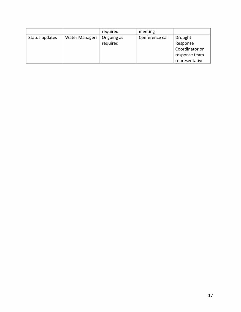
required meeting Status updates Water Managers Ongoing as
required Conference call Drought
Response Coordinator or response team representative

18
Table 5. Communication matrix – external to government.
Key Message Target Audience*
Timing Method Lead
Drought Levels 3 and 4
General public, water users, water boards, purveyors, First Nations and Director of FrontCounter BC
Declaration of Level 3 or 4
Media release & email/phone calls to licensees and water utilities. Mailed letters may also be sent.
River Forecast Center Drought Response Coordinator with assistance from Government Communication and Public Engagement (GCPE), Senior and District Water Officers
Regulatory Action
Non-domestic Licensees, Purveyors, FCBC
When approaching critical flow thresholds for fish
Phone or email distribution. Possibility of mailed letters.
Senior Water Officers, District Water Officers
Non-regulatory Requests for Reduction
All Water Users in a specific area, FCBC
When exceeding environmental flow needs threshold for fish
Phone or email distribution, local media
Senior Water Officers, District Water Officers
Status updates Bailiffs At beginning of drought season and then as required
Phone, email or face to face meeting
Senior Water Officers, District Water Officers
Status updates Water boards (OBWB), Salmon River Round Table, BC Cattleman’s / Stock Breeders, BC Fruit Growers of BC, Winery Associations, Fraser Basin Council
At beginning of drought season and then ongoing particularly when changes in drought conditions occur.
Face to face meeting and/or emails and phone calls
Agriculture Resource Specialist, Senior Water Officers, District Water Officers

19
Table 4. Communication Matrix – external (continued)
Key Message Target Audience*
Timing Method Lead
Status updates First Nations At beginning of drought season and then ongoing as changes in drought condition or response occur.
Face to face meeting, phone calls, letters and emails
First Nations Coordinator and District Advisors, District Resource Managers
Status updates Local Government, Regional Districts
At beginning of drought season and then ongoing as required
Phone call or face to face meeting
Senior Water Officers, District Water Officers
Adding streams to Stream watch list
First Nations, Licensees, OBWB
Ongoing as required
Email Senior Water Officers, District Water Officers
General information
Regional media Broadcast
At start of drought season and ongoing as required
Mass media release, email distribution
Drought Response Coordinator with assistance from GCPE
Early season drought forecast
Non-Domestic Licensees, water utilities, bailiffs, OBWB
Early each spring Public Meeting Senior Water Officers, District Water Officers Agriculture Resource Specialist
Angling Closures Regional media broadcast, FCBC
Stream flow and or temperature thresholds are exceeded
Mass media release
GCPE with provincial Fisheries staff
The 2015 drought response highlighted opportunities for improving communication, particularly with water licensees:
• Include a drought information bulletin with Annual Licensee billing. • Develop area based licensee email distribution lists to facilitate effective and efficient
communication with water users.

20
• Develop email distribution lists for: 1) Internal groups; 2) external groups; and 3) First Nations.
These improvements will be pursued on an ongoing basis as resources are made available.
9 Training Effective drought management requires practitioners to be proficient in an assortment of skills, ranging from measuring stream flows and assessing habitat values to interpreting flow data and preparing legal orders. This knowledge and skillset is developed through training and regular practice. With staffing changes and potentially infrequent drought occurrence, training can be targeted for new staff and as a refresher for experienced staff. Drought training will be both technical and knowledge based and in order to keep current with the science, policy, and legislation behind drought management decisions, drought management training should be offered to regional staff on an annual basis. The 2015 drought response highlighted the need for both technical and policy-related training. Training will be conducted early enough in the season to prepare staff before drought conditions are in effect. An equipment inventory should also be completed at this time to ensure each response centre is adequately equipped to measure stream flows. Training modules to be developed include:
• Stream flow measurements o how to measure, o Timing of measurements o Frequency of measurements during the drought o choosing the appropriate equipment for measuring flow in a specific stream
• Selecting priority streams for monitoring • Data management
o Where is it stored o How is data managed o Who is responsible for managing it o EFN and CFN levels
• Interpretation of ground versus surface water use. How to utilize monitoring wells. • Estimating agricultural water demand • Using mobile devices for data collection • Interpreting data and reports
o Analysis and interpretation of reports. o WSC data o Consultant data o Data tracking and reporting
• Applying “First in Time First in Rights” (FITFIR). Natural Resource Officers (NRO) will also be offered this training.

21
• Preparing Section 86, 87 and 88 Orders. While regional staff will not be approving Orders, they will be tasked with following a specific process for gathering the appropriate information to support the Orders. Training will include the process behind each of these Orders and the information staff must collect to satisfy the Comptroller and or Minister decision making. Provincial templates and guidance for Order preparation will provide for consistency.
Training will include the development of case studies for specific watersheds which will be used to cover a number of aspects of stream monitoring and data management skill development. There was an identified to include First Nations in stream flow data collection, as highlighted during the 2015 drought experience. A regional effort is underway to identify First Nations that may have the capacity and are willing to assist with stream flow data collection. Stream flow assessment training will be offered to First Nations stream monitors.

22
APPENDICES
Appendix 1. Definitions “summer baseflow” – the lowest monthly flow during the summer irrigation season (July – September) for each year, geometric mean (1 in 2 year frequency), over the period of record (Table 1).
Table 6. Example calculation of summer baseflow.
Year Monthly flow (l/s) Summer baseflow (l/s)
Jul Aug Sep
1985 419 226 350 226 1986 1150 277 216 216 1987 257 136 92 92 1988 673 236 225 225 1989 625 327 312 312 1990 1200 291 200 200 Mean 721 249 233 200 Max 1200 327 350 312 Min 257 136 92 92
Water Act "officer" means
(a) a person or class of persons employed by the government or a government corporation and designated in writing by the comptroller as an officer, or
(b) a conservation officer defined in section 1 (1) of the Environmental Management Act;
"order" includes a decision or direction, whether given in writing or otherwise;
"regulate" includes allow, commence, stop, limit, open, shut and prohibit;
Water Sustainability Act "critical environmental flow threshold", in relation to the flow of water in a stream, means the volume of water flow below which significant or irreversible harm to the aquatic ecosystem of the stream is likely to occur;

23
Appendix 2. Additional information required for watch list streams
Field Name Definition Source Date Date of flow Discharge Flow rate in cubic meters per second. WSC website Percentile flow Indicates the percentage of historic flows on the
date of interest that are lower than the observed flow
http://watermonitor.gov/naww/index.php
Drainage area The size of the watershed WSC website Error Error between predicted and measured flow at last
WSC streamflow measurement WSC website
QC Quality control: whether the discharge is a pass, fail, or requires correction
Assessed by Regional Team
Corrected discharge
The adjusted value as required by QC Calculated by Regional Team
Quartile The distribution of flow records has four quartiles that are bounded by: (1) the minimum value; (2) the mid-point between the minimum value and the median value; (3) the median value; (4), the mid-point between the median value and maximum value; and (5) the maximum value.
WSC website
Long-term Mean Annual Discharge (LT MAD)
The average flow for each year averaged over the period of record
HYDAT, Hydromaster
Average summer baseflow (% LT MAD)
The minimum monthly flow through the summer season (e.g., July – Sept.), average for the period of record expressed as a percentage of MAD.
WSC, Hydromaster
Percent LT MAD The discharge for the date of interest expressed as % LT MAD.
Calculated ratio
Critical rearing flow threshold (l/s)
The predetermined minimum critical flow to sustain a population of a given species of fish in a stream, expressed in liter per second discharge
Critical rearing flow threshold (% MAD)
The predetermined minimum critical flow to sustain a population of a given species of fish in a stream, expressed in a percentage of mean annual discharge
Critical spawning flow threshold (l/s)
The predetermined minimum critical flow to sustain adults and eggs of a given species of fish in a stream, expressed in liter per second discharge
Critical spawning flow threshold (% MAD)
The predetermined minimum critical flow to sustain adults and eggs of a given species of fish in a stream, expressed in a percentage of mean annual discharge.

24
Appendix 3. 2015 Regional Drought Response Team - Sample Name Affiliation Role
Phil Belliveau FLNRO Ecosystems Regional Drought Response Coordinator
Bruce McFarlane FLNRO Regional Operations Division
Regional Specialist – Hydrologist
Andrew Petersen Agriculture – Business Development Division
Regional Specialist – Agriculture
Rich McCleary FLNRO Ecosystems Regional Specialist – Aquatic Ecology
Christian St. Pierre
FLNRO Ecosystems Regional Specialist – Aquatic Ecology
Kim DeRose FLNRO Regional Ops - Cascades
District Water Officer
Patrick Farmer FLNRO Regional Ops - Cascades
District Water Officer
Colleen Dreger FLNRO Regional Ops – Thompson Rivers
District Water Officer
Murray Allison FLNRO Regional Ops – Thompson Rivers
District Water Officer
Ray Reilly FLNRO Regional Ops – Okanagan Shuswap
District Water Officer
Dale Richter FLNRO Regional Ops – Okanagan Shuswap
District Water Officer

25
Appendix 4. Flow chart showing the drought assessment and response process

26
Appendix 5. Relevant Legislation – Flow Regulation For a complete list of related legislation, see the British Columbia Drought Response Plan. Highly relevant legislation includes the following:
Water Sustainability Act: Division 5 — Temporary Protection Orders
Declarations of significant water shortage
86 (1) If the minister considers that one or more streams in an area have
fallen or are at risk of falling below their critical environmental flow thresholds, the minster may make a temporary order declaring a significant water shortage in the area designated in the order.
(2) An order under subsection (1) must specify the term of the order, which term may not exceed 90 days.
(3) Whether or not a temporary order under subsection (1) has been made or expired, if the Lieutenant Governor in Council considers that one or more streams in an area have fallen or are at risk of falling below their critical environmental flow thresholds, the Lieutenant Governor in Council may make an order declaring a significant water shortage in the area designated in the order.
(4) When an order of the Lieutenant Governor in Council under subsection (3) comes into force, an order under subsection (1) in relation to the same designated area expires.
(5) Section 124 (4) (d) [general regulation-making powers] applies to an area designated in an order under subsection (1) or (3).
Critical environmental flow protection orders
87 (1) If an order under section 86 (1) or (3) is in force, the comptroller
must, for the purposes of section 22 (9) [precedence of rights], by order, determine in accordance with any applicable regulations, the critical environmental flow threshold for each stream that meets all of the following criteria:
(a) the stream is in the area designated in the order and has a regionally significant aquatic ecosystem;

27
(b) water is being diverted from the stream under this Act or the stream is hydraulically connected to an aquifer from which water is being diverted under this Act;
(c) the comptroller considers that enforcing the precedence of the stream's critical environmental flow threshold under section 22 (9) will assist in preventing significant or irreversible harm to the aquatic ecosystem of the stream.
(2) If the comptroller considers that more than one stream in an area to which an order under section 86 (1) or (3) applies is described in subsection (1), the comptroller may determine the critical environmental flow thresholds for the streams based on the degree of benefit the comptroller considers the aquatic ecosystems of the streams would derive from enforcement of the precedence of their critical environmental flow thresholds, in descending order, beginning with the stream that would derive greatest benefit and stopping
(a) when the critical environmental flow threshold has been determined for all of the streams described in subsection (1), or
(b) if the order under section 86 (1) or (3) expires before paragraph (a) applies, upon that expiry.
(3) An order under subsection (1) is final and may not be appealed to the appeal board.
(4) An order under subsection (1) and the implementation, under this Act, of the precedence provided for in section 22 (9) apply
(a) despite the rights of any person who, under this Act, is diverting or using water from the stream or the aquifer hydraulically connected to the stream, as the case may be, and
(b) whether or not a right that is acquired, accrued or accruing under this Act at any time before or after the coming into force of this section is affected by the order.

28
Fish population protection orders
88 (1) If the minister considers that the flow of water in a specified
stream is or is likely to become so low that the survival of a population of fish in the stream may be or may become threatened, the minister may make an order respecting the diversion, rate of diversion, time of diversion, or use, including storage and time of storage, of water from the specified stream, or a specified aquifer hydraulically connected to the stream, regardless of the precedence set out in section 22 [precedence of rights].
(2) The minister may make an order under subsection (1) only after giving due consideration to the needs of agricultural users.
(3) An order under subsection (1) must specify the term of the order.
(4) An order under subsection (1) applies
(a) despite the rights of any person who, under this Act, is diverting or using water from the specified stream or the specified aquifer, as the case may be, and
(b) whether or not a right that is acquired, accrued or accruing under this Act at any time before or after the coming into force of this section is affected by the order.

29
Appendix 6. Example Current Stream Conditions Report (CSCR) W
SC S
tn N
ame
WSC
Stn
ID
Stre
am N
ame
Dis
tric
t
Obs
erva
tion
by
MAD
(L/s
)
DA
(km
2)
Alt T
ype
Dat
e of
Flo
w
Mea
sure
men
t
Flow
(L/s
)
Flow
%M
AD
Sum
mer
CPS
F (%
mad
)
Criti
cal r
earin
g flo
w(L
/s)
Criti
cal l
ate
sum
mer
m
igra
tion
(L/s
)
Criti
cal l
ate
sum
mer
spaw
ning
(L
/s)
Ratio
of f
low
to
criti
cal r
earin
g
Ratio
of f
low
to
criti
cal l
ate
Ratio
of f
low
to
criti
cal l
ate
Species of Spawning Fish Present
CH
CO
KO
RT
BT
Tulameen R at Princeton 08NL024 Tulameen Cascades WSC 21800 1760 D
2015-09-08 2167 10 13 1090 4360 2180 1.99 0.50 0.99 N N N Y N
Tulameen River below Vuich Creek 08NL071 Tulameen Cascades WSC 6480 256 N
2015-09-08 698 11 10 324 1296 648 2.15 0.54 1.08 N N N Y N
Similkameen River near
Hedley 08NL038 Similkameen Cascades WSC 54700 5590 D 2015-09-08 7935 15 15 4020 16080 8040 1.97 0.49 0.99 N N N Y N
Coldwater river at Merritt 08LG010
Coldwater R. Cascades WSC 9510 914 D
2015-09-08 1487 16 8 476 1902 951 3.13 0.78 1.56 Y Y N Y Y
Nicola River at Spences
Bridge 08LG006 Nicola R Cascades WSC 29843 7280 D 2015-09-08 5783 19 18 2870 11480 5740 2.02 0.50 1.01 Y Y N Y N
Coldwater river near
Brookmere 08LG048 Coldwater
R. Cascades WSC 6880 316 N 2015-09-08 1395 20 13 362 1448 724 3.85 0.96 1.93 Y Y N Y Y
Inkaneep Creek near the mouth 08NM200 Inkaneep DOS WSC 1135 227 D
2015-09-08 18 2 3 57 227 114 0.32 0.08 0.16 N N N Y N
Two Forty One Creek
near Penticton 08NM241
Two Forty One Cr DOS WSC 55 5 N
2015-09-08 1 2 7 3 11 6 0.36 0.09 0.18 N U N U U
Granby R at Grand Forks 08NN002 Granby DOS WSC 30900 2050 D
2015-09-08 1506 5 9 1545 6180 3090 0.97 0.24 0.49 N N N Y U
West Kettle River at
Westbridge 08NN003 W. Kettle DOS WSC 12853 1820 D 2015-09-08 766 6 13 643 2571 1285 1.19 0.30 0.60 N N N Y N
Kettle River near
Westbridge 08NN026 Kettle DOS WSC 27811 2150 D 2015-09-08 1747 6 17 1480 5920 2960 1.18 0.30 0.59 N N N Y N
Whiteman Creek above
Bouleau Creek 08NM174
Whiteman Ck DOS WSC 631 112 N
2015-09-08 42 7 12 32 126 63 1.32 0.33 0.66 N U N U U

30
Appendix 7. Regional Stream Watch List Table 7. Water Survey of Canada real-time gauging station locations that can be used to assess drought level.
Station Name Count Station Number Flow Type District Precinct Name
Tulameen River Below Vuich Creek 1 08NL071 Natural Cascades Tulameen Whiteman Creek Above Bouleau Creek 2 08NM174 Natural Okanagan Shuswap Vernon Pennask Creek Near Quilchena 3 08LG016 Natural Cascades Upper Nicola Coldstream Creek Above Municipal Intake 4 08NM142 Natural Okanagan Shuswap Okanagan Centre Coldwater River Near Brookmere 5 08LG048 Natural Cascades Merritt Camp Creek At Mouth Near Thirsk 6 08NM134 Natural Okanagan Shuswap Summerland Vaseux Creek Above Solco Creek 7 08NM171 Natural Okanagan Shuswap Fairview Two Forty-One Creek Near Penticton 8 08NM241 Natural Okanagan Shuswap Penticton Chase Creek Above The Mouth 9 08LE112 Regulated Thompson Rivers Ducks Salmon River At Falkland 10 08LE020 Regulated Thompson Rivers Grand Prairie Salmon River Near Salmon Arm 11 08LE021 Regulated Thompson Rivers Grand Prairie Bonaparte River Below Cache Creek 12 08LF002 Regulated Thompson Rivers Bonaparte Nicola River At Outlet Of Nicola Lake 13 08LG065 Regulated Cascades Lower Nicola Nicola River Above Nicola Lake 14 08LG049 Regulated Cascades Upper Nicola Granby River At Grand Forks 15 08NN002 Regulated Okanagan Shuswap Grand Forks West Kettle River At Westbridge 16 08NN003 Regulated Okanagan Shuswap Westbridge Kettle River Near Westbridge 17 08NN026 Regulated Okanagan Shuswap Westbridge Mission Creek Near East Kelowna 18 08NM116 Regulated Okanagan Shuswap Kelowna Similkameen River At Princeton 19 08NL007 Regulated Cascades Princeton Tulameen River At Princeton 20 08NL024 Regulated Cascades Princeton Coldwater River At Merritt 21 08LG010 Regulated Cascades Merritt Nicola River Near Spences Bridge 22 08LG006 Regulated Cascades Spences Bridge Similkameen River Near Hedley 23 08NL038 Regulated Okanagan Shuswap Hedley Inkaneep Creek Near The Mouth 24 08NM200 Regulated Okanagan Shuswap Fairview Shatford Creek Near Penticton 25 08NM037 Regulated Okanagan Shuswap Penticton Trepanier Creek Near Peachland 26 08NM041 Regulated Okanagan Shuswap Peachland Lemieux Creek 08LB078 Thompson Rivers Barriere Guichon Cr 08LG067 Cascades Lower Nicola Deadman River above Criss Creek 08LF027 Thompson Rivers Deadman Barrier River at the Mouth 08LB020 Thompson Rivers Barriere

31
Harper Creek near the Mouth 08LB076 Thompson Rivers Barriere Spius Creek near Canford 08LG008 Cascades Merritt Bessette Creek above Beaverjack Creek 08LC039 Okanagan Shuswap Lumby Criss Creek near Savona 08LF007 Thompson Rivers Deadman
Table 3. Candidate watch list streams requiring manual measurement (this table needs additional information).
Stream Name Count District Station no Canoe Cr 27 Thompson Rivers 08LE004 East Canoe Cr 28 Thompson Rivers 08LE108 Monte Cr 29 Thompson Rivers 08LE013 Cache Cr 31 Thompson Rivers 08LF004 Louis Cr 32 Thompson Rivers 08LB072 Clapperton Cr 33 Cascades 08LG015 Tranquille Cr 35 Thompson Rivers 08LF024 Raft River 38 Thompson Rivers 08LB017 Mann Cr 39 Thompson Rivers 08LB050 Quilchena Cr 41 Cascades 08LG017 Palmer Cr 42 Okanagan Shuswap 08LE072 Hat Cr 43 Thompson Rivers 08LF015 Arrowstone Cr 44 Thompson Rivers 08LF099 Allison 45 Okanagan Shuswap 08NL012 Summers 46 Okanagan Shuswap 08NL019 Bessette 47 Okanagan Shuswap 08LC042 Duteau 48 Okanagan Shuswap 08LC006 Creighten 49 Okanagan Shuswap 08LC033 Ashton 50 Okanagan Shuswap Brash 51 Okanagan Shuswap 08LC004 Fortune 52 Okanagan Shuswap 08LC035

32
Blurton 53 Okanagan Shuswap 08LC025 Trinity 54 Okanagan Shuswap 08LC050 Gardom 55 Okanagan Shuswap 08LC036 Falls Cr 56 Okanagan Shuswap Middle Vernon 57 Okanagan Shuswap 08NM043 Trout 58 Okanagan Shuswap 08NM158