COUNTY OF PLACER PLANNING
56
COUNTY OF PLACER PLANNING Michael J Johnson, AICP Paul Thompson, Deputy Director TO: FROM: Michael J. Johnson, AICP Agency Director DATE: January 8,2013 MEMORANDUM • SUBJECT: GREYHAWK II (PSUB 2011 ACTION REQUESTED 1. Conduct a Public Hearing to consider a Rezone for the Greyhawk II 21-lot Planned Residential Development. 2. Adopt the Mitigated Negative Declaration, including the Mitigation Monitoring Program, for the Greyhawk II Project: and 3. Adopt an Ordinance to Rezone Assessor's Parcel Number 048-151-083-000 from RS-8-40 PD=2 (Residential Single-Family, combining a minimum Building Site of 40.000 sq. ft., combining Planned Residential Development of 2 dwelling units per acre) to RS-B-X-18.000 PD=2.8 (Residential Single-Family. combining a minimum Building Site of 18.000 sq. ft .• combining Planned Residential Development of 2.8 dwelling units per acre). There is no net County cost associated with these actions. PROPOSAL Greyhawk II is a proposal to develop a 21-lot Planned Residential Development on a 10.3-acre infill site in Granite Bay. The project would include 21 single-family residential home sites situated along a private internal loop road that runs through the property. Over 61 percent of the project site would remain as open space areas. There would be a central common area internal to the lots (Lot A), a common area lot surrounding the private looped roadway (Lot E). and a 3.8-acre open space lot over the southern portion of the site (Lot B) for the purpose of preserving and protecting natural resources (100-year floodplain and Strap Ravine). The private road and public utility easement is contained within Lot C. Lot D is a 0.07 acre parcel containing an existing access easement to the adjacent Bellatierra Business Park commercial development. All open space/common lot areas would be maintained by the Homeowners Association. The single-family residences (including garages) would be constructed within building envelopes of approximately 3.900 square feet (60 x 65 feet). The configuration of a typical home in the building envelope would include a living area (±2.685 square feet). covered patio at the rear (±3OO square feet). front courtyard (±225 square feet). and three-car garage (±600 square feet). A garden area (20 x 60 feet) of approximately 1.200 square feet is planned for the rear of each residence. and garden areas are not included within the building envelopes. While rear patio areas may be fenced with wood, ornamental. or plaster walls for privacy, the garden areas would not be fenced. Building 12-1
Transcript of COUNTY OF PLACER PLANNING

COUNTY OF PLACER
PLANNING
Michael J Johnson, AICP
Paul Thompson, Deputy Director
TO:
FROM: Michael J. Johnson, AICP Agency Director
DATE: January 8,2013
MEMORANDUM
•
SUBJECT: GREYHAWK II (PSUB 2011
ACTION REQUESTED
1. Conduct a Public Hearing to consider a Rezone for the Greyhawk II 21-lot Planned Residential Development.
2. Adopt the Mitigated Negative Declaration, including the Mitigation Monitoring Program, for the Greyhawk II Project: and
3. Adopt an Ordinance to Rezone Assessor's Parcel Number 048-151-083-000 from RS-8-40 PD=2 (Residential Single-Family, combining a minimum Building Site of 40.000 sq. ft., combining Planned Residential Development of 2 dwelling units per acre) to RS-B-X-18.000 PD=2.8 (Residential Single-Family. combining a minimum Building Site of 18.000 sq. ft .• combining Planned Residential Development of 2.8 dwelling units per acre).
There is no net County cost associated with these actions.
PROPOSAL Greyhawk II is a proposal to develop a 21-lot Planned Residential Development on a 10.3-acre infill site in Granite Bay. The project would include 21 single-family residential home sites situated along a private internal loop road that runs through the property. Over 61 percent of the project site would remain as open space areas. There would be a central common area internal to the lots (Lot A), a common area lot surrounding the private looped roadway (Lot E). and a 3.8-acre open space lot over the southern portion of the site (Lot B) for the purpose of preserving and protecting natural resources (100-year floodplain and Strap Ravine). The private road and public utility easement is contained within Lot C. Lot D is a 0.07 acre parcel containing an existing access easement to the adjacent Bellatierra Business Park commercial development. All open space/common lot areas would be maintained by the Homeowners Association.
The single-family residences (including garages) would be constructed within building envelopes of approximately 3.900 square feet (60 x 65 feet). The configuration of a typical home in the building envelope would include a living area (±2.685 square feet). covered patio at the rear (±3OO square feet). front courtyard (±225 square feet). and three-car garage (±600 square feet). A garden area (20 x 60 feet) of approximately 1.200 square feet is planned for the rear of each residence. and garden areas are not included within the building envelopes. While rear patio areas may be fenced with wood, ornamental. or plaster walls for privacy, the garden areas would not be fenced. Building
12-1

footprints, including the patio area, would account for a total 24.5 percent attributable to residential unit coverage. Most of the lots would have single-story residences, and Lots 1, 2, and 3 would be restricted to one-story in height to be more compatible with the existing Greyhawk Subdivision located adjacent to these lots.
Access to the project site would be provided by the existing stub/terminus of Greyhawk Drive at its intersection with Woodgrove Way. The private internal loop road would be 25-feet-wide with a "no parking" restriction along the entire roadway. Resident parking would be accommodated within the three-car garages, and guest parking is planned in five small bays off the private internal loop road and at a ratio of one guest parking space per lot as required by the Zoning Ordinance. A gated entry is also proposed and would feature ornamental landscaping and hardscape features. Along the perimeter of the neighborhood, a six-foot-high privacy fence adjacent to existing residential areas (east) is proposed, with the option for tubular steel/open fencing adjacent to the office land uses (north and west).
Required entitlements include a Vesting Tentative Subdivision Map, Conditional Use Permit, and Variance. In addition, a Rezone from RS-B-40 PD=2 (Residential Single-Family, combining a minimum Building Site of 40,000 sq. ft., combining Planned Residential Development of 2 dwelling units per acre) to RS-B-X-18,000 PD=2.8 (Residential Single-Family, combining a minimum Building Site of 18,000 sq. ft., combining Planned Residential Development of 2.8 dwelling units per acre) is also being requested.
PLANNING COMMISSION ACTION At its November 8, 2012 meeting, the Planning Commission unanimously adopted a motion (6:0:1:0 with Commissioner Brentnall absent) to approve a Vesting Tentative Subdivision Map and Conditional Use Permit to allow for a 21-lot Planned Residential Development, and Variances to the Zoning Ordinance requirements for minimum driveway lengths, minimum open space requirements, and maximum building coverage. The Planning Commission also forwarded a recommendation to the Board of Supervisors to approve the Rezone request.
The majority of the public comments at the Planning Commission meeting focused on the proposed pedestrian gate located at the northern property boundary of the Greyhawk II subdivision. This gate is not required by the County, and the developer has agreed to remove the gate as a result of concerns expressed by the property owner to the north of the Greyhawk II subdivision. This property owner did not want anyone gaining access to their private property from the Greyhawk II subdivision.
In addition, the Planning Commission revised Condition 29 to add that "the entry pedestrian gate shall be unlocked from dawn to dusk" and the Planning Commission concluded that the proposed Rezone request is consistent with applicable policies and requirements of the Granite Bay Community Plan and is consistent with the land uses in the immediate area and therefore recommended that Board of Supervisors approve the proposed Rezone request.
PROPOSED REZONE Development of Greyhawk II as proposed would require the Board's approval of a Rezone that would increase the density from two dwelling units per acre to 2.8 dwelling units per acre (RS-B-40 PD=2 to RS-B-X-18,000 PD=2.8) on the project site. The benefit for the community would be the complete preservation of Strap Ravine and the 1 OO-year floodplain on both sides of the ravine. As such, approximately 70 per cent of the 10.3-acre site would remain as Open Space/Common Areas. The preservation of the southern portion of the Site would benefit the Granite Bay community by protecting Strap Ravine and the adjacent sensitive environment.
2
122

Staff supports this Rezone request because of the unique design of the proposal and the physical constraints of the site. The project design elements utilize small building envelopes with common areas between and behind the lots. Other unique design elements include shorter driveways and a narrower looping access road. As a result of incorporation of these project design elements, density can be increased within the northern portion of the site without the appearance of a denser project that would normally occur with a typically lot and block Planned Residential Development. In addition, the design allows for the southern portion of the site to be preserved in perpetuity. Lastly, the Rezone request is in compliance with the land use density range identified in the Granite Bay Community Plan.
FISCAL IMPACT There is no impact to the General Fund as a result of this action.
RECOMMENDATION: Staff recommends the Board of Supervisors take the following actions:
1. Adopt the Mitigated Negative Declaration including the Mitigation Monitoring Program for the Greyhawk II project based upon the following findings:
A. The Mitigated Negative Declaration for the Greyhawk II project has been prepared as required by law. With the incorporation of all mitigation measures, the project is not expected to cause any significant adverse impacts. Mitigation measures include, but are not limited to removal and/or impacts to protected oak trees, removal of a small vernal pool and seasonal wetland, and Best Management Practice (BMP) measures shall be required to reduce erosion, water quality degradation, and prevent the discharge of pollutants to the 1 OO-year floodplain and Strap Ravine to the maximum extent practicable.
B. There is no substantial evidence in the record as a whole that the project as mitigated may have a significant effect on the environment.
C. The Mitigated Negative Declaration as adopted for the project reflects the independent judgment and analysis of Placer County, which has exercised overall control and direction of its preparation.
D. The custodian of records for the project is the Placer County Planning Director, 3091 County Center Drive, Suite 140, Auburn CA, 95603.
2. Adopt the Ordinance as set forth in Attachment 2 approving a Rezone of Assessor's Parcel Number 048-151-083-000 from RS-B-40 PD=2 (Residential Single-Family, combining a minimum Building Site of 40,000 sq. ft., combining Planned Residential Development of 2 dwelling units per acre) to RS-B-X-18,000 PD=2.8 (Residential Single-Family, combining a minimum Building Site of 18,000 sq. ft., combining Planned Residential Development of 2.8 dwelling units per acre), based on the following findings:
A. The zoning, as amended through this action, is consistent with applicable policies and requirements of the Placer County General Plan and the Granite Bay Community Plan and is consistent with the land uses in the immediate area.
B. The proposed zoning would not represent spot zoning and would not be contrary to the orderly development of the area.
Attached to this report for the Board's information/consideration are:
3
Il3

ATTACHMENTS: Attachment 1: Vicinity Map Attachment 2: Proposed Ordinance Attachment 3: Mitigated Negative Declaration and Mitigation Monitoring Program Attachment 4: Vesting Tentative Subdivision Map Attachment 5: Planning Commission Staff Report dated November 1, 2012
cc: Michael Johnson - CDRA Director Paul Thompson· Deputy Planning Director E.J. Ivaldi • Supervising Planner Karin Schwab· County Counsel's Office Rebecca Taber· Engineering and Surveying Division Janelle Heinzler - Department of Facility Services Laura Rath • Environmental Health Services Andy Fisher· Parks Department Andrew Gaber· Department of Public Works
4

j T
PPB
MAP NO SCALE
Placer County
I .. Blvd.
125 ATTACHMENT 1

Before the Board of Supervisors County of Placer, State of California
Ordinance No.: c::------FIRST READING ____ _
In the matter of: AN ORDINANCE AMENDING PLACER COUNTY CODE, CHAPTER 17, MAP E1, RELATING TO REZONING APN 048-151-083-000, GREYHAWK II SUBDIVISION (PSUB 20110048)
The following Ordinance was duly passed by the Board of Supervisors of the County of
Placer at a regular meeting held _________ , by the following vote on roll
call:
Ayes:
Noes:
Absent:
Signed and approved by me after its passage.
Attest: Clerk of said Board Chair, Board of Supervisors
Clerk of the Board Signature Chair Signature
THE BOARD OF SUPERVISORS OF THE COUNTY OF PLACER, STATE OF CALIFORNIA, DOES HEREBY ORDAIN AS FOLLOWS:
1. The Placer County Code, Chapter 17, Map E1, relating to Rezoning APN 048-151-083-000, the Greyhawk II SubdiVision, is amended from RS-B-40 PD=2 (Residential Single-Family, combining a minimum Building Site of 40,000 sq. ft., combining Planned Residential Development of 2 dwelling units per acre) to RSB-X-18,000 PD=2.8 (Residential Single-Family, combining a minimum Building Site of 18,000 sq. ft., combining Planned Residential Development of 2.8
JJ. b ATTACHMENT 2
PAGE 2 ORDINANCE NO. _____ _
dwelling units per acre). The Board finds that assignment of the new zone district is consistent with applicable pOlicies and requirements of the Granite Bay Community Plan and is consistent with the land uses in the immediate area.
2. Notice of all hearings required by statute and ordinance has been given and all hearings have been held as required by statute and ordinance.
NOW, THEREFORE, BE IT ORDAINED BY THE BOARD OF SUPERVISORS OF THE COUNTY OF PLACER:
Section 1: That portion of Chapter 17 of the Placer County Code relating to zoning in the Greyhawk II Subdivision, is amended from RS-B-40 PD=2 (Residential SingleFamily, combining a minimum Building Site of 40,000 sq. ft., combining Planned Residential Development of 2 dwelling units per acre) to RS-B-X-18,000 PD=2.8 (Residential Single-Family, combining a minimum Building Site of 18,000 sq. ft., combining Planned Residential Development of 2.8 dwelling units per acre) as shown on Exhibit A, attached hereto and incorporated herein by reference.
Section 2: This ordinance shall take effect and be in full force and effect upon thirty (30) days after its passage. The Clerk is directed to publish this ordinance, or a summary thereof, within fifteen (15) days in accordance with Government Code Section 25124.
127

Rezone Exhibit Greyhawk II Subdivision !
\ ; !
\ ) · '~""'.J......,- 1-" -,,""-'--' l '~.-- I
I -_____ J
, •
L-----. __ -J"
I I ,~ \~ , r-'m \f.\
III r-
OP-UP-DLO-Dc
Current Zoning: RS~B-40 PD = 2
Proposed Zoning: RS-B-X-18,000 PD 2.8
Acres: 10.3
APN, 048-151-083-000
SHADYBROOK Cr
WOOD SPRINGS CT
G)
'" m -<
"'~ ::;;
POPLAR CT
'I I,
O'l-DAlEC/ ~O " "
<Q
RS-AG-B-IOO PD ~0.44
.. ~ ___ , 1 i~ ,0
'"
.• ' o 100 ?OO
CPD-Dc
400
~~~§iiiiiiiiiiiiiiiiil Feet
<;~I'-EAMSIDEC~
RS-AG-B-/OO PD c." , ~
CHESTNU 0=0 0.96
>-'!l: UJ
"" o tt: <!)
'" C o ~
~ P"h S\CDRAIREQUESTS\PQ_L"tIARCMAP\;'{hoWkIl_B&W_121lOB.m" I "-- • EUREKA RD .... •
~L. __________ ~ ____ ~.:-: .. -:.:.-: .. :-: .. -:.:.-= .. -:.:--: .. :~~.:.-:--:::-.:-:.:-:::: .. :-::_:_::i:.:::::::::::::::::t ________ ~::::(;~ ____ .J
m >< ::J: -IX! ::::j »

COUNTY OF PLACER Community Development Resource Agency
Michael J. Johnson, AICP Agency Director
NOTICE OF INTENT
ENVIRONMENTAL COORDINATION
SERVICES
E. J Ivaldi, Coordinator
TO ADOPT A MITIGATED NEGATIVE DECLARATION
The project listed below was reviewed for environmental impact by the Placer County Environmental Review Committee and was determined to have no significant effect upon the environment. A proposed Mitigated Negative Declaration has been prepared for this project and has been filed with the County Clerk's office.
PROJECT: Greyhawk II Planned Residential Development (PSUB 20110048)
PROJECT DESCRIPTION: The applicant proposes a Rezone, Vesting Tentative Subdivision Map, Conditional Use Permit, and Variance to develop 21 single-family residences on 21 lots in a planned residential development on a 1 0.3-acre property.
PROJECT LOCATION: West of the intersection of Greyhawk Drive and Woodgrove Way, east of Sierra College Blvd., south of Douglas Blvd and north of Eureka Road, Granite Bay, Placer County
APPLICANT: Westwood Homes Inc., 5300 Montserrat Lane, Loomis, CA 95650 (916)652-5200
The comment period for this document closes on October 18, 2012. A copy of the Negative Declaration is available for public review at the County's web site http://www.placer.ca.gov/Departments/CommunityDevelopmentlEnvCoordSvcs/NegDec.aspx Community Development Resource Agency public counter, and at the Granite Bay Public Library. Property owners within 300 feet of the subject site shall be notified by mail of the upcoming hearing before the Planning Commission. Additional information may be obtained by contacting the Environmental Coordination Services, at (530)745-3132, between the hours of 8:00 am and 5:00 pm, at 3091 County Center Drive, Auburn, CA 95603.
Published in Sacramento Bee on Wednesday, September 19, 2012
3091 County Center Drive, Suite 190 , Auburn, California 95603 / (530) 745-3132 I Fax (530) 745-3080 , email: cdraecs@placer,ca_gov j~ q ATTACHMENT 3

J I
" .
MAP
Placer County
I}-D

II
COUNTY OF PLACER Community Development Resource Agency
Michael J. Johnson, AICP Agency Director
ENVIRONMENTAL COORDINATION
SERVICES
E. J. Ivaldi, Coordinator
MITIGATED NEGATIVE DECLARATION II In accordance with Placer County ordinances regarding implementation of the California Environmental Quality Act, Placer County has conducted an Initial Study to determine whether the following project may have a significant adverse effect on the environment, and on the basis of that study hereby finds:
D The proposed project will not have a significant adverse effect on the environment; therefore, it does not require the preparation of an Environmental Impact Report and this Negative Declaration has been prepared.
r8l Although the proposed project could have a significant adverse effect on the environment, there will not be a Significant adverse effect in this case because the project has incorporated speCific provisions to reduce impacts to a less than Significant level andlor the mitigation measures described herein have been added to the project A Mitigated Negative Declaration has thus been prepared.
The environmental documents, which constitute the Initial Study and provide the basis and reasons for this determination are attached andlor referenced herein and are hereby made a part of this document
PROJECT INFORMATION
Title: Greyhawk II Planned Residential Development !Plus# PSUB 20110048
Description: The applicant proposes a Rezone, Vesting Tentative Subdivision Map, Conditional Use Permit, and Variance to develop 21 single-family residences on 21 lots in a planned residential development on a 10.3-acre property.
Location: West of the intersection of Greyhawk Drive and Woodgrove Way, east of Sierra College Blvd., south of Douglas Blvd and north of Eureka Road, Granite Bay, Placer County
Project Owner/Applicant: Westwood Homes Inc., 5300 Montserrat Lane, Loomis, CA 95650 (916)652-5200
County Contact Person: Roy Schaefer 1530-745-3061
PUBLIC NOTICE
The comment period for this document closes on October 18,2012. A copy of the Negative Declaration is available for public review at the County's web site (http://wwwplacerca.gov/Departments/CommunityDevelopmenVEnvCoordSvcs/NegDec.aspx), Community Development Resource Agency public counter, and at the Granite Bay Public Library. Property owners within 300 feet of the subject site shall be notified by mail of the upcoming hearing before the Planning Commission. Additional information may be obtained by contacting the Environmental Coordination Services, at (530)745-3132 between the hours of 8:00 am and 5:00 pm at 3091 County Center Drive, Auburn, CA 95603. For Tahoe projects, please visit our Tahoe Office, 775 North Lake Blvd., Tahoe City, CA 96146.
If you wish to appeal the appropriateness or adequacy of this document, address your written comments to our finding that the project will not have a significant adverse effect on the environment: (1) identify the environmental effect(s), why they would occur, and why they would be significant, and (2) suggest any mitigation measures which you believe would eliminate or reduce the effect to an acceptable level. Regarding item (1) above, explain the basis for your comments and submit any supporting data or references. Refer to Section 18.32 of the Placer County Code for important information regarding the timely filing of appeals.
3091 County Center Drive, Suite 190 I Auburn, California 95603 I (530) 745-3132 I Fax (530) 745-3080 I email: [email protected] J31

".d,i', 1'9 1,0-
- - - _____ ~ - ____ ~ I :~~;,::~;;"I' ".I,
,------
~ I ''''''-': )( _L ,0-~'O~-C30-~,I' ,jif
fif i'JJ U; I m,J
~8f'-I~I-2v" ~r~v
;:"-Il, '1:D~ ""~""ns p"~Y~II~S'
, , , , , , , ,
_____ L. ___ _
/
I
/
r
,-- - --
\~
~ <D" , ,,- ::;: ~ !':' "~ d. ~ [,c'"
r
!
!
_J
/

COUNTY OF PLACER Community Development Resource Agency
Michael J. Johnson, AICP Agency Director
ENVIRONMENTAL COORD INA TION
SERVICES
E. J. Ivaldi, Coordinator
3091 County Center Drive, Suite 190 • Auburn. California 95603 • 530-745-3132 • fax 530-745-3080 • W'N\III,placer Ga.gov
INITIAL STUDY & CHECKLIST
This Initial Study has been prepared to identify and assess the anticipated environmental impacts of the following described project application. The document may rely on previous environmental documents (see Section C) and site-specific studies (see Section I) prepared to address in detail the effects or impacts associated with the project.
This document has been prepared to satisfy the California Environmental Quality Act (CEQA) (Public Resources Code, Section 21000 et seq.) and the State CEQA Guidelines (14 CCR 15000 et seq.) CEQA requires that all state and local government agencies consider the environmental consequences of projects over which they have discretionary authority before acting on those projects.
The Initial Study is a public document used by the decision-making lead agency to determine whether a project may have a significant effect on the environment. If the lead agency finds substantial evidence that any aspect of the project, either individually or cumulatively, may have a significant effect on the environment, regardless of whether the overall effect of the project is adverse or beneficial, the lead agency is required to prepare an EIR, use a previously-prepared EIR and supplement that EIR, or prepare a Subsequent EIR to analyze the project at hand. If the agency finds no substantial evidence that the project or any of its aspects may cause a significant effect on the environment, a Negalive Declaration shall be prepared. If in the course of analysis, the agency recognizes that the project may have a significant impact on the environment, but that by incorporating specific mitigation measures the impact will be reduced to a less than significant effect, a Mitigated Negative Declaration shall be prepared.
Project Title: Greyhawk II Planned Residential Development I Plus# PSUB20110048
Entitlement(s): Rezone, Vesting Tentative Subdivision Map, Conditional Use Permit, & Variance
Site Area: 10.3 acres I APN 048-151-083 Location: West of the existing stub/terminus and intersection of Greyhawk Drive and Woodgrove Way in Granite Bay, Placer County
A. BACKGROUND:
Project Description Greyhawk II is a proposal to develop a 21-lot planned residential development on a 10.3-acre infill site in Granite Bay The project would include 21 single-family residential home sites situated along a private internal loop road that runs through the community. Over 70% of the project site would remain as open space and/or common areas. There would be a central common open space area (Lot A) internal to the lots and the southern portion of the site (Lot B - 3.8 acres) would be preserved to protect natural resources (1 OO-year floodplain and Strap Ravine).
The single-family residences (including garages) would be constructed in building envelopes of approximately 3,900 square feet (60 x 65 feet). The configuration of a typical home in the building envelope would include a living area (±2,685 square feet), covered patio at the rear (±300 square feet), front courtyard (±225 square feet), and three-car garage (±600 square feet). A garden area (20 x 60 feet) of approximately 1,200 square feet is planned to the rear of each residence, and garden areas are not included within the building envelopes. Rear patio areas may be fenced with wood, ornamental or plaster walls for privacy. Building footprints, including the patio area, would account for approximately 18.2% and 6.3% of the project site, for a total of 24.5% attributable to residential unit coverage. Residences would primarily be single-story, but may also include two-story structures.
T:\ECS\EQ\PSUB 2011 0048 greyhawk II\Neg Dec\lnitial studLECSdoc

Greyhawk II Initial Study & Checklist continued
Access to the project site would be provided from the east side, at the exisling stub/terminus of the Greyhawk Dnve and Woodgrove Way intersection. The private Internal loop road would be 25-feet wide with a "no parking" restnction along the entire roadway Resident parking would be accommodated within the three-car garages and guest parking is planned In five small bays of 90-degree parking off of the private internal loop road and at a ratio of one guest parking space per lot A pnvate, gated entrance is also proposed and would feature ornamental landscaping and hardscape features. Along the perimeter of the neighborhood, a six-foot high pnvacy fence adjacent to eXisting residential areas (east) IS proposed, with the option for tubular steei/open fenCing adjacent to the office land uses (north & west)
Project entitlements requested include a Rezone, Vesting Tentative Subdivision Map, Conditional Use Permit and a Variance. The project site is proposed to be rezoned from RS-B-40 PD 2 (Residential Single-Family, combining Building Site of 40,000 square feet, combining Planned Residential Development 2 units per acre) to RS-B-X-18,000 PD 2.8 (Residential Single-Family, combining Building Site of 18,000 square feet, combining Planned Residential Development 2.8 units per acre), consistent with the Granite Bay Community Plan land use designation for the site of "Low Density Residential (OA-0.9 acres per dwelling unit)". The Vesting Tentative Subdivision Map and Conditional Use Permit is required for the subdivision of 103 acres into a 21-lot residential Planned Development. There is a Variance request to constructing the County minimum length of 20-foot driveways in front of garages per Zoning Ordinance Sections 17.54.070.A and 17.54.140A.E; the project requires a minimum driveway apron of 8 feet. There is also a Variance request to the minimum Open Space and maximum coverage standards in Section 17.54.100A3.; the project has 61% (6.3 acres) of Open Space where 71% (7.3 acres) is required and the project has 24.5% maximum coverage where 15% is allowed by the Zoning Ordinance.
Project Site (Background/Existing Setting): The project site is currently undeveloped with no existing structures. It is bordered by commercial development to the north and west, residential development (Greyhawk Subdivision) to the east, and undeveloped residential zoned property to the south. Topography consists of moderately hilly to undulating terrain that slopes from the highest point along the northern boundary towards the lower fiood plain terrace of Strap Ravine. The northern portion of the study area supports open disturbed grassland dominated by soft chess, filaree, smooth cats tongue, and rat-tail fescue. Other common species include Spanish clover, wild oats, two-color lupine, silver hairgrass, and Fitch's spikeweed.
Oak woodland habitat, prevalent in the lower terrace adjacent to Strap Ravine, is generally characterized by a canopy of interior live oak with a sparse shrub layer of Himalaya blackbenry, coyote brush, and poison oak. Other common canopy species include blue oak, valley oak, foothills pine, and Fremont cottonwood. The dense grassland understory includes rip-gut brome, soft chess, oats, Spanish clover, barbed goat grass, dogtail, bedstraw, and vetch.
A vernal pool and one seasonal wetland occur in a shallow depression located in the upper terrace of the study area. The vernal pool sustains long-term ponding and saturation conditions that persist during and following periods of heavy precipitation in the winter and early spring. It is dominated by Carter's buttercup and loosestrife. Other common associates include flowering quillwort, slender popcorn flower, white-tip clover, Mediterranean barley, perennial rye, and toad rush.
Seasonal wetlands occur in shallow to medium depth depressions in the lower fioodplain terrace of the study area that is hydrologically connected to Strap Ravine via seasonal surface overfiow and/or groundwater fiuctualions. The seasonal wetlands are generally dominated by Ballic rush with common species including willow herb, curly dock, perennial rye, Mediterranean barley, and rough cocklebur.
The riparian wetland habitat associated with Strap Ravine is generally characterized by a canopy of Goodding's willow, arroyo willow, and Fremont cottonwood with a scattered shrub understory of Himalaya blackberry. Other common riparian species include valley oak and red willow. Associated emergent marsh habitat within Strap Ravine includes broad-leaf cattail, Baltic rush, soft rush, tall flatsedge, spikerush, water plantain, sedge, velvet grass, and dallis grass.
Initial Study & Checklist 2 of 32
,34

I
Greyhawk II Initial Study & Checklist continued
B. ENVIRONMENTAL SETTING:
Location
Residential Single-Family, combining Building Site of 40 000
Site square feet. combining Planned , ReSidential Development 2 units
per acre (RS-B-40 PD = 2) Office Professional, Combining Use
Permit, combining Density North Limitation 0, combining Design
Scenic Corridor (OP-UP-OLO-Dc)
South same as project site Residential Single-Family,
combining Agricultural, combining
East Building Site of 2.3 acres,
combining Planned Residential Development OA4 units per acre
(RS-AG-B-1DD PD = OA4) Office Professional, Combining Use
West Permit, combining Density
Limitation 0, combining Design Scenic Corridor (OP-UP-OLD-Dc)
C. PREVIOUS ENVIRONMENTAL DOCUMENT:
General Pian/Community Plan Desl nations
Granite Bay Community Plan/Low Density Residential
(OA-0.9 acre minimum)
Granite Bay Community Plan /Professional Office
same as project site
Rural Low Density Residential (0.9- 2.3 acre minimum)
Granite Bay Community Plan IProfessional Office
I Undeveloped
Granite Bay Business Park
Undeveloped
Greyhawk I Subdivision
Paramount Equity Office
The County has determined that an Initial Study shall be prepared in order to determine whether the potential exists for unmitigatable impacts resulting from the proposed project. Relevant analysis from the County-wide General Plan and Community Plan Certified EIRs, and other project-specific studies and reports that have been generated to date, were used as the database for the Initial Study. The decision to prepare the Initial Study utilizing the analysis contained in the General Plan and SpeCific Plan Certified EIRs, and project-specific analysis summarized herein, is sustained by Sections 15168 and 15183 of the CEQA Guidelines.
Section 15168 relating to Program EIRs indicates that where subsequent activities involve site-specific operations, the agency would use a written checklist or similar device to document the evaluation of the site and the activity, to determine whether the environmental effects of the operation were covered in the earlier Program EIR. A Program EIR is intended to provide the basis in an Initial Study for determining whether the later activity may have any significant effects. It will also be incorporated by reference to address regional influences, secondary effects, cumUlative impacts, broad alternatives, and other factors that apply to the program as a whole.
The following documents serve as Program-level EIRs from which incorporation by reference will occur + Placer County General Plan EIR + Granite Bay Community Plan EIR
Section 15183 states that "projects which are consistent with the development density established by existing zoning, community plan or general plan policies for which an EIR was certified shall not require additional environmental review, except as may be necessary to examine whether there are project-specific significant effects which are peculiar to the project or site." Thus, if an impact is not peculiar to the project or site, and it has been addressed as a significant effect in the prior EIR, or will be substantially mitigated by the imposition of uniformly applied development policies or standards, then additional environmental documentation need not be prepared for the project solely on the basis of that impact.
The above stated documents are available for review Monday through Friday, 8am to 5pm, at the Placer County Community Development Resource Agency, 3091 County Center Drive, Auburn, CA 95603. For Tahoe projects, the document will also be available in our Tahoe Division Office, 565 West Lake Blvd., Tahoe City, CA 96145.
D. EVALUATION OF ENVIRONMENTAL IMPACTS:
The Initial Study checklist recommended by the State of California Environmental Quality Act (CEQA) Guidelines is used to determine potential impacts of the proposed project on the physical environment. The checklist provides a list of questions concerning a comprehensive array of environmental issue areas potentially affected by the project
Initial Study & Checklist 3 of 32
I

Greyhawk II Initial Study & Checklist continued
(see CEQA Guidelines, Appendix G). Explanations to answers are prOVided In a discussion for each section of questions as follows
a) A brief explanation is required for all answers Including "No Impact" answers. b) "Less Than Significant Impact" applies where the project's impacts are insubstantial and do not require any
mitigation to reduce impacts. c) "Less Than Significant with Mitigation Measures" applies where the incorporation of mitigation measures has
redLced an effect from "Potentially Significant Impact" to a "Less than Significant Impact." The County, as lead agency, must describe the mitigation measures, and briefiy explain how they reduce the effect to a less~than~ significant level (mitigation measures from earlier analyses may be cross~referenced).
d) "Potentially Significant Impact" is appropriate if there is substantial evidence that an effect may be significant. If there are one or more "Potentially Significant Impact" entries when the determination IS made, an EIR is required
e) All answers must take account of the entire action involved, including off~site as well as on~slte, cumulative as well as project~level, indirect as well as direct, and construction as well as operational impacts [CEQA Guidelines, Section 15063(a)(1 )],
I) Earlier analyses may be used where, pursuant to the tiering, Program EIR, or other CEQA process, an effect has been adequately analyzed in an earlier EIR or Negative Declaration [CEQA Guidelines, Section 15063(c)(3)(0)], A brief discussion should be attached addressing the following:
+ Earlier analyses used - Identify earlier analyses and state where they are available for review. + Impacts adequately addressed - Identify which effects from the above checklist were within the scope of,
and adequately analyzed in, an earlier document pursuant to applicable legal standards. Also, state whether such effects were addressed by mitigation measures based on the earlier analysis.
+ Mitigation measures - For effects that are checked as "Less Than Significant with Mitigation Measures," describe the mitigation measures which were incorporated or refined from the earlier document and the extent to which they address site~specific conditions for the project.
g) References to information sources for potential impacts (i.e. General Plans/Community Plans, zoning ordinances) should be incorporated into the checklist. Reference to a previously~prepared or outside document should include a reference to the pages or chapters where the statement is substantiated. A source list should be attached and other sources used, or individuals contacted, should be cited in the discussion.
Initial Study & Checklist 4 of 32

Greyhawk II Initial Study & Checklist continued
I. AESTHETICS - Would the project:
Less Than Potentially Significant Less Than
No Environmental Issue Significant with Significant
Impact Impact Mitigation Impact Measures
i
1. Have a sUbstantial adverse effect on a scenic vista? (PLN) i I X I I
2. Substantially damage scenic resources, including, but not limited to, trees, rock outcroppings, and histonc buildings, X within a state scenic highway? (PLN)
3. Substantially degrade the existing visual character or quality X of the site and its surroundings? (PLN)
4. Create a new source of substantial light or glare, which would adversely affect day or nightllme views in the area? X (PLN)
Discussion- Item 1-1: The proposed project will not have a substantial adverse effect on a scenic vista as it is not located on or near a scenic vista.
Discussion- Item 1-2: The proposed project will not substantially damage scenic resources within a state scenic highway as it is not located on or near a scenic highway.
Discussion- Item 1-3: The existing visual character of the area can be described as undeveloped, with a topography that consists of moderately hilly to undulating terrain that slopes from the highest point along the northern boundary towards the lower floodplain terrace of Strap Ravine. The proposed project would result in the construction of 21 new residences, extensive new landscaping, fencing, and an internal private looping roadway with a gated entry area. As part of these improvements, 15 native oak trees would be removed. Although there is a potential for the visual character or quality of the site to be impacted, approximately 75.5% would remain as common space, open space and private roads including 3.8 acres of 100-year floodplain and Strap Ravine (designated as Lot B on vesting tentative subdivision map). There is also 1-acre of riparian setback area that would remain undeveloped within the southern portion of the site. This in combination with extensive landscaping proposed adjacent to the private road, within the common lot areas (Lot A) and landscaping in the perimeter areas adjacent to the north and west property boundaries would reduce any potential visual impact to a level less than significant No mitigation measures are required.
Discussion- Item 1-4: The proposed project would create 21 residential lots, which would result in an incremental increase in new sources of night lighting in the area. Street lighting is proposed for the private road for safety purposes at roadway intersections, similar to other areas in the community There is no outdoor lighting proposed within the open space/common area lots New sources of outdoor lighting typically associated with residential uses would be introduced into the area; however, this lighting would be consistent with residential neighborhoods in the area and would not result in any substantial light and/or glare that would affect night time views in the area. To ensure that lighting standards on individual properties and within the subdivision are enforced in a manner consistent with the neighboring community, as well as ensure that individual properties are not subject to undue light trespass from neighboring properties, the following standard condition of approval will be applied to the project: Prior to recordation of the Final Map, the applicant shall submit lighting development standards for inclusion in the CC&R's. The standards shall be reviewed and approved by the Development Review Committee and shall include General Lighting Standards, Residential Standards, Prohibited Lighting and Exemptions, and shall ensure that individual fixtures and other lighting in the subdivision will be designed, constructed, and installed in a manner that controls glare and light trespass, minimizes obtrusive light, and conserves energy and resources. No mitigation measures are required.
PlN=Planning, ESD=Engineering & Surveying Department, EHS=Environmental Health Services, APCD=Air Pollution Control District 5 of 32
137

Greyhawk II Initial Study & Checklist continued
II. AGRICULTURAL & FOREST RESOURCES - Would the prolect
Less Than Potentially Significant Less Than No
Environmental Issue Significant with Significant Impact Impact Mitigation Impact
Measures , 1. Convert Prime Farmland, Unique Farmland, or Farmland of ,
I i
Statewide or Local Importance (Farmland), as shown on the , maps prepared pursuant to the Farmland Mapping and I X Monitoring Program of the California Resources Agency, to non-agricultural use? (PLN)
2 Conflict with General Plan or other policies regarding land X
use buffers for agricultural operations? (PLN)
3. Confiict with existing zoning for agricultural use, a Williamson X
Act contract or a Right-to-Farm Policy? (PLN)
4. Conflict with existing zoning for, or cause rezoning of, forest land (as defined In Public Resources Code section 12220(g)), timberland (as defined by Public Resources Code section X 4526), or timberland zoned Timberland Production (as defined b1f Government Code section 511 04(q))? (PLN) 5. Involve other changes in the existing environment which, due to their location or nature, could result in the loss or conversion
X of Farmland (including livestock grazing) or forest land to non-agricultural or non-forest use? (PLN)
Discussion- All Items: This is an infill project within an urbanized area of Granite Bay that is surrounded by low density residential developments and commercial land uses. The prOject site has not been historically used for agricultural purposes and is not designated as Prime, Unique, Statewide or Local Farmland as shown on maps pursuant to the Farmland Mapping and Monitoring Program of the California Resources Agency. The property is not under a Williamson Act contract.
III. AIR QUALITY - Would the project
Less Than Potentially Significant Less Than No
Environmental Issue Significant with Significant Impact Impact Mitigation Impact Measures
1. Conflict with or obstruct implementation of the applicable air X
quality plan? (PLN, Air Quality)
2. Violate any air quality standard or contribute substantially to X
an existing or projected air quality violation? (PLN, Air Quality)
3. Result in a cumulatively considerable net increase of any criteria for which the project region is non-attainment under an applicable federal or state ambient air quality standard X (including releasing emissions which exceed quantitative thresholds for ozone precursors)? (PLN, Air Quality)
4. Expose sensitive receptors to substantial pollutant X
concentrations? (PLN, Air Quality)
5. Create objectionable odors affecting a substantial number of X
people? (PLN, Air Quality)
PLN=Planning, ESD=Engineering & Surveying Department, EHS=Environmental Health Services, APCD=Air Pollution Control District 6 of 32
i

Greyhawk II Initial Study & Checklist continued
Discussion- Item 111-1: The project IS located within the Sacramento Valley Air Basin (SVAB) portion of Placer County. The Greyhawk II site IS an infill residential, planned development Single-family residences will be situated amid open space areas and will be constructed with a consistent architectural fashion. The proposed project consists of 21 residential lots on a 10. 3-acre site, with approximately 70 percent of the property set aSide for open space The Increase In density resulting from the newly created parcels would not contribute a significant impact to Region, as the related emissions would be below the significant level. No mitigation measures are required.
Discussion- Items 111-2,3: The project site is located within the SVAB and is under the Jurisdiction of the Placer County Air Pollution Control District (APCD). The SVAB is designated non-attainment for the federal and state ozone standards (Reactive Organice Gases (ROG) and Oxides of Nitrogen (NO,)), non-attainment for the 24-hour federal particulate matter standard (PM,,) and non-attainment for the state particulate matter standard (PM 1O).
In order to reduce construction related air emissions, associated grading plans shall list the District's Rules and State Regulations. A Dust Control Plan shall be submitted to the Placer County Air Pollution Control District for approval prior to the commencement of earth disturbing activities demonstrating all proposed measures to reduce air pollutant emissions. The operational- related emissions resulting from the additional dwelling units would be below the significant level and will not violate air quality standards or substantially contribute to existing air quality violations. With the implementation of the following mitigation measures and notes on the grading improvement plans, construction related emissions would not result in a cumulatively considerable net increase of any nonattainment criteria.
Mitigation Measures-Items 111-2,3: MM 111.1 1. Prior to approval of Grading Plans, the applicant shall submit a Construction Emission I Dust Control Plan to the
Placer County APCD. To download the form go to www.p/acerca.gov/apcd and click on Dust Control Requirements. If the APCD does not respond within twenty (20) days of the plan being accepted as complete, the plan shall be considered approved. The applicant shall provide written evidence, provided by APCD to the County, that the plan has been submitted to APCD. It is the responsibility of the applicant to deliver the approved plan to the County. The applicant shall not break ground prior to receiving APCD approval of the Construction Emission I Dust Control Plan, and delivering that approval to the County.
Include the following standard notes on the Grading Plans: 2. The contractor shall use CARB ultra low diesel fuel for all diesel-powered equipment 3. In order to control dust, operational watering trucks shall be on site during construction hours. In addition, dry,
mechanical sweeping is prohibited. Watering of a construction site shall be carried out in compliance with all pertinent APCD rules.
4. The prime contractor shall be responsible for keeping adjacent public thoroughfares clean of silt, dirt, mud, and debris, and shall "wet broom" the streets (or use another method to control dust as approved by the individual jurisdiction) if silt, dirt, mud or debris is carried over to adjacent public thoroughfares.
5. The contractor shall apply water or use other method to control dust impacts offsite. Construction vehicles leaving the site shall be cleaned to prevent dust, silt, mud, and dirt from being released or tracked off-site.
6. During construction, traffic speeds on all unpaved surfaces shall be limited to 15 miles per hour or less. 7. The prime contractor shall suspend all grading operations when wind speeds (including instantaneous gusts)
are excessive and dust is impacting adjacent properties. 8. In order to minimize wind driven dust during construction, the prime contractor shall apply methods such as
surface stabilization, establishment of a vegetative cover, paving, (or use another method to control dust as approved by the individual jurisdiction).
9. The contractor shall suspend all grading operations when fugitive dust exceeds Placer County APCD Rule 228 (Fugitive Dust) limitations. The prime contractor shall be responsible for having an individual who is CARBcertified to perform Visible Emissions Evaluations (VEE). This individual shall evaluate compliance with Rule 228 on a weekly basis. It is to be noted that fugitive dust is not to exceed 40% opacity and not go beyond the property boundary at any time. Lime or other drying agents utilized to dry out wet grading areas shall not exceed Placer County APCD Rule 228 Fugitive Dust limitations Operators of vehicles and equipment found to exceed opacity limits will be notified by APCD and the equipment must be repaired within 72 hours.
10. Construction equipment exhaust emissions shall not exceed Placer County APCD Rule 202 Visible Emission limitations. Operators of vehicles and equipment found to exceed opacity limits are to be immediately notified by APCD to cease operations and the equipment must be repaired within 72 hours.
11. A person shall not discharge into the atmosphere volatile organic compounds (VOC's) caused by the use or
PLN=Planning, ESD=Engineering & Surveying Department, EHS=Environmental Health Services, APCD=Air Pollution Control District 7 of 32

Greyhawk II Initial Study & Checklist continued
manufacture of Cutback or Emulsified asphalts for paving. road construction or road maintenance. unless such manufacture or use complies with the provisions of Rule 217
12. During construction the contractor shall utilize existing power sources (eg, power poles) or clean fuel (i.e gasolIne, blodiesel, natural gas) generators rather than temporary diesel power generators
13. During constructIon, the contractor shall minimIze idlIng tIme to a maximum of 5 mInutes for all diesel powered equIpment.
14. During construction, no open burning of removed vegetation shall be allowed unless permitted by the PCAPCD All removed vegetatIve material shall be either chIpped on site or taken to an appropriate recycling sIte, or if a site is not avaIlable, a lIcensed dIsposal site.
Discussion- Item 111-4: The project includes minor grading operations which may result in short-term diesel PM emissions from on-site heavy-duty equIpment required for site grading. Because of the dispersIve propertIes of diesel PM and the temporary nature of the mobIlIzed equipment use, short-term construction-generated Toxic Air Contaminant emissions would not expose sensitive receptors to substantial pollutant concentrations and therefore would have a less than significant effect. No mitigation measures are required
Discussion- Item 111-5: The project would result in additional air pollutant emissions generated by diesel-powered construction equipment, and vehicle exhaust from traffio that could oreate odors. However, the long-term operational emissions (vehicle traffic) from this project alone will not exceed the District's significant thresholds. Therefore, potential impaots from odors will be less than significant. No mitigation measures are required.
IV. BIOLOGICAL RESOURCES - Would the project:
Less Than Potentially Significant Less Than
No Environmental Issue Significant with Significant Impact
Impact Mitigation Impact Measures
1. Have a substantial adverse effect, either directly or through habitat modifications, on any species identified as a oandidate, sensitive, or special status species in local or regional plans,
X policies or regulations, or by the California Department of Fish & Game, U.S. Fish & Wildlife Service or National Oceanic and Atmospheric Administration Fisheries? (PLN) 2. Substantially reduce the habitat of a fish or wildlife species, cause a fish or wildlife population to drop below self-sustaining levels, threaten to eliminate a plant or animal community, X substantially reduce the number of restrict the range of an endangered, rare, or threatened species? (PLN)
3. Have a substantial adverse effect on the environment by X converting oak woodlands? (PLN)
4. Have a substantial adverse effect on any riparian habitat or other sensitive natural community, including oak woodlands, identified in local or regional plans, policies or regulations, or by
X the California Department of Fish & Game, U.S. Fish & Wildlife Service, US. Army Corps of Engineers or National Oceanic and Atmospheric Administration Fisheries? (PLI'Il 5. Have a substantial adverse effect on federal or state protected wetlands as defined by Section 404 of the Clean Water Act (including, but not limited to, marsh, vernal pool,
X coastal, etc.) or as defined by state statute, through direct removal, filling, hydrological interruption, or other means? (PLN) 6. Interfere substantially with the movement of any native resident or migratory wildlife species or with established native
X resident or migratory wildlife corridors, or impede the use of native wildlIfe nesting or breeding sites? (PLN)
PLN-Plannrng, ESD-Engmeenng & SurveYing Department, EHS=EnVifonmental Health Services, APCD-Alr Pollution Control District 8 of 32
Greyhawk II Initial Study & Checklist continued
1
7. Conflict with any local policies or ordinances that protect . biological resources, including oak woodland resources? (PLN)
I 8 Conflict with the provIsions of an adopted Habitat ! I Conservation Plan, Natural Community Conservation Plan, or ' i other approved local, regional. or state habitat conservation
plan? (PLN)
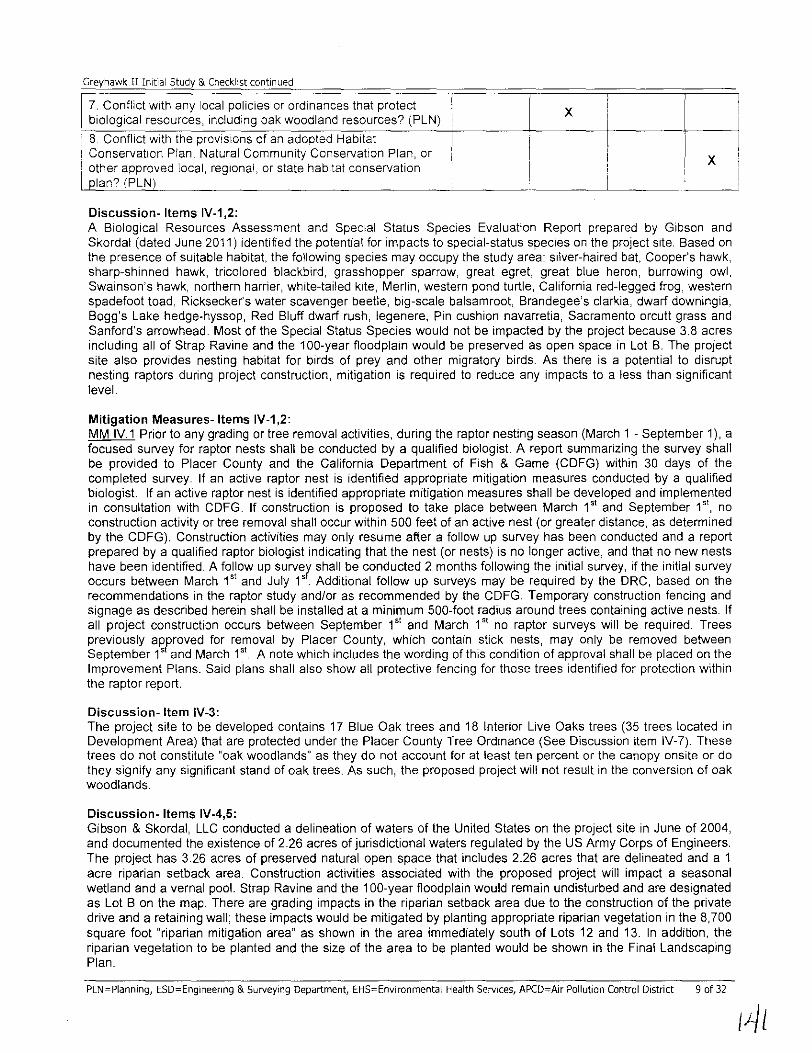
Discussion-Items IV-1,2:
x i ! ! x
A Biological Resources Assessment and Special Status Species Evaluation Report prepared by Gibson and Skordal (dated June 2011) identified the potential for impacts to special-status species on the project site. Based on the presence of suitable habitat, the following species may occupy the study area: silver-haired bat, Cooper's hawk, sharp-shinned hawk, tricolored blackbird, grasshopper sparrow, great egret, great blue heron, burroWing owl, Swainson's hawk, northern harrier, white-tailed kite, Merlin, western pond turtle, California red-legged frog, western spadefoot toad, Ricksecker's water scavenger beetle, big-scale balsam root, Brandegee's clarkia, dwarf downingia, Bogg's Lake hedge-hyssop, Red Bluff dwarf rush, legenere, Pin cushion navarretia, Sacramento orcutt grass and Sanford's arrowhead. Most of the Special Status Species would not be impacted by the project because 3.8 acres including all of Strap Ravine and the 1 OO-year fioodplain would be preserved as open space in Lot B. The project site also provides nesting habitat for birds of prey and other migratory birds. As there is a potential to disrupt nesting raptors during project construction, mitigation is required to reduce any impacts to a less than significant level.
Mitigation Measures-Items IV-1,2: MM IV.1 Prior to any grading or tree removal activities, during the raptor nesting season (March 1 - September 1), a focused survey for raptor nests shall be conducted by a qualified biologist A report summarizing the survey shall be provided to Placer County and the California Department of Fish & Game (CDFG) within 30 days of the completed survey. If an active raptor nest is identified appropriate mitigation measures conducted by a qualified biologist If an active raptor nest is identified appropriate mitigation measures shall be developed and implemented in consultation with CDFG. If construction is proposed to take place between March 1" and September 1", no construction activity or tree removal shall occur within 500 feet of an active nest (or greater distance, as determined by the CDFG). Construction activities may only resume after a follow up survey has been conducted and a report prepared by a qualified raptor biologist indicating that the nest (or nests) is no longer active, and that no new nests have been identified. A follow up survey shall be conducted 2 months following the initial survey, if the initial survey occurs between March 1" and July 1'. Additional follow up surveys may be required by the DRC, based on the recommendations in the raptor study and/or as recommended by the CDFG. Temporary construction fencing and signage as described herein shall be installed at a minimum 500-foot radius around trees containing active nests. If all project construction occurs between September 1" and March 1" no raptor surveys will be required. Trees previously approved for removal by Placer County, which contain stick nests, may only be removed between September l' and March 1'" A note which includes the wording of this condition of approval shall be placed on the Improvement Plans. Said plans shall also show all protective fencing for those trees identified for protection within the raptor report.
Discussion- Item IV-3: The project site to be developed contains 17 Blue Oak trees and 18 Interior Live Oaks trees (35 trees located in Development Area) that are protected under the Placer County Tree Ordinance (See Discussion item IV-7). These trees do not constitute "oak woodlands" as they do not account for at least ten percent or the canopy onsite or do they signify any significant stand of oak trees. As such, the proposed project will not result in the conversion of oak woodlands.
Discussion- Items IV-4,5: Gibson & Skordal, LLC conducted a delineation of waters of the United States on the project site in June of 2004, and documented the existence of 2.26 acres of jurisdictional waters regulated by the US Army Corps of Engineers. The project has 3.26 acres of preserved natural open space that includes 2.26 acres that are delineated and a 1 acre riparian setback area. Construction activities associated with the proposed project will impact a seasonal wetland and a vernal pool. Strap Ravine and the 1 OO-year fioodplain would remain undisturbed and are designated as Lot B on the map. There are grading impacts in the riparian setback area due to the construction of the private drive and a retaining wall; these impacts would be mitigated by planting appropriate riparian vegetation in the 8,700 square foot "riparian mitigation area" as shown in the area immediately south of Lots 12 and 13. In addition, the riparian vegetation to be planted and the size of the area to be planted would be shown in the Final Landscaping Plan.
PLN-Planning, ESD-Engineering & Surveying Department, EHS-Environmental Health Services, APCD-Air Pollution Control District 9 of 32
I
I~l

Greyhawk II Initial Study & Checklist continued
The project as proposed would remove a 194 square foot Vernal Pool (northwest corner of site) and a 387 square foot Seasonal Wetland (east central area of site) Protocol-level surveys (Helm Biological Consulting) for Vernal Pool Branchlopods were conducted, but no Vernal Pool Branchiopods were detected. A mitigation measure is Included for the removal of the Vernal Pool and the Seasonal Wetland
Mitigation Measures- Items IV-4,5: MM IV 2 The wetlands report shall be field verified by the US Army Corps of Engineers, the US Fish & Wildlife Service, and the California Department of Fish & Game as deemed necessary by Design Review Committee prior to the filing of the Final Map If significant discrepancies arise between the report and the field investigation of these agencies, the DeSign Review Committee shall schedule a hearing before the Planning Commission to consider revocation or modification of the project's permit approvals.
MM IV.3 Provide written evidence that compensatory habitat has been established through the purchase of mitigation credits at a County qualified wetland mitigation bank. The amount of money required to purchase credits shall be equal to the amount necessary to replace wetland or riparian habitat acreage and resource values including compensation for temporal loss. The total amount of habitat to be replaced is 0.13 acres (194 square foot Vernal Pool and 387 square foot seasonal wetland) of wetland habitat (the regulatory agencies may require a different ratio that will need to be satisfied). Evidence of payment, which describes the arnount and type of habitat purchased at the bank site, must be provided to the County prior to issuance of Improvernent Plans or Building Permits which would result in the degradation or loss of the habitat The amount to be paid shall be the fee in effect at the time the Final Map is recorded.
In addition, for the grading impacts within the riparian setback area the riparian enhancement requirement would be to plant one square foot of riparian vegetation for every square foot of impact within the riparian setback area. The riparian plants selected and size of the area to be planted shall be shown on the Final Landscaping Plan for the project
MM IVA The applicant shall install permanent protective fencing, as may be approved by the Design Review Committee, with upright posts embedded (or other demarcation approved by the Development Review Committee) in concrete along and around all wetland preservation easement boundaries on Lot B to the satisfaction of the Design Review Committee. Such fencing shall provide a physical demarcation to future homeowners of the location of protected easement areas or Open Space/Comrnon Area lots as required by other conditions of this project Such fencing shall be shown on the Inforrnation Sheet recorded concurrently with the Final Map as well as on the project Improvement Plans.
Discussion- Item IV-6: Although the project site supports various habitat Iypes, there are no known native resident or rnigratory wildlife corridors within the project area, or its vicinity. This is an infill project that is surrounded by low density residential developments, and commercial land uses, and does not lend support to such corridors. No mitigation measures are required.
Discussion-Item IV-7: An Arborist Report prepared by Sierra Nevada Arborists (dated September 21,2010) identified 35 native trees in the development area of the site, which included 18 Interior Live Oaks and 17 Blue Oaks. A total of 12 oak trees are proposed to be removed (11 Blue Oaks and 1 Interior Live Oak) with the proposed subdivision improvements and another three oak trees would be removed due to the nature and extent of defects, compromised health andlor structural instability noted at the time of the Arborist's field inventory.
Mitigation Measures- Items IV-7: MM IV.5 Trees identified for removal, andlor trees with disturbance to their drip lines, shall be replaced with comparable species onsite, in an area to be reviewed and approved by the Design Review Committee, as follows: a) For each diameter inch of a tree removed, replacement shall be on an inch-for-inch basis. For example, if 100 diameter inches are proposed to be removed, the replacement trees would equal 100 diameter inches (aggregate). If replacement tree planting is required, the trees must be installed by the applicant and inspected and approved by the Design Review Committee, prior to the acceptance of improvements by the Engineering and Surveying Department At its discretion, the Design Review Committee, may establish an alternate deadline for installation of mitigation replacement trees if weather or other circumstances prevent the completion of this requirement; or b) In lieu of the tree planting mitigation for tree removal listed above, a contribution of $100 per diameter inch at breast height for each tree removed or impacted or the current market value, as established by an Arborist, Forester or Registered Landscape Architect, of the replacement trees, including the cost of installation, shall be paid to the Placer County Tree Preservation Fund. If tree replacement mitigation fees are to be paid in the place of tree replacement mitigation planting, these fees must be paid prior to acceptance of improvements.
PlN=Planning, ESD=Engineering & Surveying Department, EHS=Environmental Health Services, APCD=Air Pollution Control District 10 of 32

Greyhawk II Initial Study & Checklist continued
Discussion- Item IV-S: At the present time, Placer County has not adopted a Habitat Conservation Plan or a Natural Communities Conservation Plan.
V, CULTURAL RESOURCES - Would the project
Less Than Potentially Significant Less Than
No Environmental Issue Significant with Significant
Impact Impact Mitigation Impact
Measures 1, Substantially cause adverse change in the significance of a historical resource as defined in CEQA Guidelines, Section X 15064,5? (PLN) 2, Substantially cause adverse change in the significance of a unique archaeological resource pursuant to CEQA Guidelines, X Section 150645?-(PLN)
3, Directly or indirectly destroy a unique paleontological X resource or site or unique geologic feature? (PLN)
4, Have the potential to cause a physical change, which would X
affect unique ethnic cultural values? (PLN)
5, Restrict existing religious or sacred uses within the potential X impact area? (PLN)
6, Disturb any human remains, including these interred outside X of formal cemeteries? (PLN)
Discussion-Items V-1,2: A Cultural Resources Assessment was prepared by Peak & Associates, Inc, for the project site in 2003 and the assessment was subsequently updated in October of 2010, Most of the project area had faIC visibility of ground surfaces, with a heavy growth of forbs and scattered trees, The drainage (Strap Ravine) along the southern portion of the property supports heavy riparian growth of willow, oak and cottonwood, There was no surface evidence of prehistoric sites within the project area, The creek course was altered within the project area due to dredging activities, and there is no likelihood for buried sites with the site disturbance that has occurred in this area,
One historic feature was present on the site - a cement-cased well with a pump and windmill, This feature was recorded in 2003 and given the primary number P-31-3098 in the statewide system, The windmill was in fair condition, and the evaluation of the resource concluded that it was not eligible for the California Register of Historical Resources, The feature has been removed from the property and a site form has been prepared and will be filed with the North Central Information Center,
As there is always the risk of the inadvertent discovery of unknown resources, standard construction conditions will apply to this project as follows: "If any archaeological artifacts, exotic rock (non-native), or unusual amounts of shell or bone are uncovered during any onsite construction activities, all work must stop immediately in the area and a qualified archaeologist shall be retained to evaluate the deposit The Placer County Planning Department and Department of Museums must also be contacted for review of the archaeological find(s), If the discovery consists of human remains, the Placer County Coroner and Native American Heritage Commission must also be contacted, Work in the area may only proceed after authorization is granted by the Placer County Planning Department A note to this effect shall be provided on the Improvement Plans for the project FOllowing a review of the new find and consultation with appropriate experts, if necessary, the authority to proceed may be accompanied by the addition of development requirements which provide protection of the site and/or additional mitigation measures necessary to address the unique or sensitive nature of the site", No mitigation measures are required,
Discussion- Item V-3: Standard construclion conditions will apply to this project and state "a note shall be placed on the improvement plans that if paleontological resources are discovered onsite, the applicant shall retain a qualified paleontologist to observe grading activities and salvage fossils as necessary, The paleontologist shall establish procedures for paleontological resource surveillance and shall establish, in cooperation with the project developer, procedures for temporarily halting or redirecting work to permit sampling, identification, and evaluation of fossils, If major PLN=Planning, ESD=Engineering & Surveying Department, EHS=Environmental Health Services, APCD=Air Pollution Control District 11 of 32

Greyhawk II Initial Study & Checklist continued
paleontological resources are discovered, which reqUIre temporary halting or redirecting of grading, the paleontologist shall report such findings to the project developer, and to the Placer County Department of Museums and Planning Department. The paleontologist shall determine appropnate actions, in cooperation with the project developer, which ensure proper exploration andlor salvage. Excavated finds shall be offered to a State designated repoSItory such as Museum of Paleontology, UC Berkeley, the California Academy of SCiences, or any other State designated repository. Otherwise, the finds shall be offered to the Placer County Department of Museums for purposes of public education and Interpretive displays. These actions. as well as final mitigation and disposition of the resources shall be subject to approval by the Department of Museums The paleontologist shall submit a followup report to the Department of Museums and Planning Department which shall include the period of inspection, an analysIs of the fossils found, and present repository of fossils". No mitigation measures are required.
Discussion- Items V-4,5: A review of the Sacred Lands File was conducted by the Native American Heritage Commission (NAHC) for the Project on October 7, 2010. The NAHC record search did not indicate the presence of cultural resources in the immediate project area. The Native American Heritage Commission provided a list of six Native American representatives who may have further knowledge of Native American resources and Peak & Associates sent letters to all six tribal contacts on October 8, 2010.
Discussion- Item V-6: There is no evidence of any kind of a burial ground within the project boundary. As such, the proposed project will not disturb any known human remains, including any remains interred outside of formal cemeteries. The standard construction conditions noted in Item 1 above will ensure that impacts remain less than significant should inadvertent discovery occur. No mitigation measures are required.
VI. GEOLOGY & SOILS - Would the project
Less Than Potentially Significant Less Than
No Environmental Issue Significant with Significant
Impact Impact Mitigation Impact
Measures
1. Expose people or structures to unstable earth conditions or X changes in geologic substructures? (ESD)
2. Result in significant disruptions, displacements, compaction X or overcrowding of the soil? (ESD)
3. Result in substantial change in topography or ground surface X relief features? (ESD)
4. Result in the destruction, covering or modification of any X unique geologic or physical features? (ESD)
5. Result in any significant increase in wind or water erosion of X soils, either on or off the site? (ESD)
6. Result in changes in deposition or erosion or changes in siltation which may modify the channel of a river, stream, or X lake? (ESD) 7. Result in exposure of people or property to geologic and geomorphological (i.e. Avalanches) hazards such as X earthquakes, landslides, mudslides, ground failure, or similar hazards? (ESDl 8. Be located on a geological unit or soil that is unstable, or that would become unstable as a result of the project, and X potentially result in on or off-site landslide, lateral spreading, subsidence, liquefaction, or collapse? (ESD) 9. Be located on expansive soils, as defined in Section 1802.3.2 of the California Building Code (2007), creating X substantial risks to life or property? (ESDi
PLN-Plannin9, ESD-Engineering & Surveying Department, EHS=Environmental Health Services, APCD=Air Pollution Control District 12 of 32
(44

Greyhawk II Initial Study & Checklist continued
Discussion-Items VI-1,2,3: This In~fill development project would result In the disturbance of approximately 6.2 acres of the 10.3 acre site for the development of 21 single~famlly residential lots, grass~lined swales for water quality treatment and drainage conveyance, underground utilities, and associated private roadway improvements Retaining walls with heights of less than five feet are proposed along portions of the site boundaries The 21 lots will be pad graded and custom one and two story wood~frame structures with Interior slab~on~grade concrete floors will be constructed as a part of the project All homes will typically Include a living area of 2,685 square feet, a covered patio at rear of 300 square feet, a front courtyard of 225 square feet, and a three~car garage of 600 square feet The project proposes approximately 4.1 acres of open space area on the south side of the property.
Access to the property is from the eXisting stubbed extension of Woodgrove Way at the intersection of Greyhawk Drive. The rectangular~shaped site is bounded to the north by existing commercial/office buildings, to the east by a single~family residential subdivision (Greyhawk I), to the south by portions of Strap Ravine and undeveloped land, and to the west by an existing office building and parking lot The site generally slopes downward in the south~ southwest direction. Based on current topographic information represented in the Preliminary Geotechnical Engineering Report prepared by Mid Pacific Engineering, Inc. (MPE) dated November 19, 2010, site elevations vary from about +230 to about +250 feet A large stockpile of soils was placed in the south~central portion of the site during previous grading operations for the adjacent office building developed to the west of the site. These soils were not compacted as engineering fills and contain various construction debris. Portions of Strap Ravine are located along the southern boundary of the site, and the flood plain prohibits grading within this area.
According to the Preliminary Geotechnical Engineering Report by MPE dated November 19, 2010, the native soil profile consists of silty sands from about two to six feet thick underlain by clayey sands, variably cemented silty sands and sandy silts and/or gravelly clean to silty sands with small cobbles. Discontinuous layers of potentially expansive clays may be present over the cemented soils. Previous work in the area indicates the permanent groundwater table is located at depths greater than 100 feet below the ground surface. Grading activities are associated with the establishment of the padded lots, retaining walls, subdivision private roadway, drainage and water quality treatment swales, and construction of underground utilities. The project grading would result in approximately 16,600 cubic yards of cut and 14,100 cubic yards of fill, and with a 15% shrink potential of approximately 2,500 cubic yards, the earthwork is proposed to balance on site. The maximum depth of cut/fill is 5 feet All resulting finished grades are proposed to be no steeper than 2: 1. The Preliminary Geotechnical Engineering Report concluded that the native soils at the site have sufficient bearing capacity to support the proposed single~ family home construction. The report concluded that the construction of the proposed improvements is feasible from a geotechnical standpoint given that the recommendations of a registered civil engineer are incorporated into the design plans and implemented during construction. However, the existing fill materials exposed in the test pits were not placed as engineered fill and must be completely removed to expose firm native ground, and replace with newly constructed engineering fill to provide adequate and uniform support for structures.
The proposed project's impacts associated with unstable earth conditions, soil disruptions, displacements, compaction of the soil, and changes to topography and ground surface relief features will be mitigated to a less than significant level by implementing the following mitigation measures:
Mitigation Measures~ Items VI~1,2,3: MM VI. 1 The applicant shall prepare and submit Improvement Plans, specifications and cost estimates (per the requirements of Section II of the Land Development Manual [LDMJ that are in effect at the time of submittal) to the Engineering and Sunveying Department (ESD) for review and approval. The plans shall show all physical improvements as required by the conditions for the project as well as pertinent topographical features both on and off site All existing and proposed utilities and easements, on site and adjacent to the project, which may be affected by planned construction, shall be shown on the plans. All landscaping and irrigation facilities within the public right~of~way (or public easements), or landscaping within sight distance areas at intersections, shall be included in the Improvement Plans. The applicant shall pay plan check and inspection fees with the 1 st Improvement Plan submittal. (NOTE: Prior to plan approval, all applicable recording and reproduction costs shall be paid). The cost of the above~noted landscape and irrigation facilities shall be included in the estimates used to determine these fees. It is the applicant's responsibility to obtain all required agency signatures on the plans and to secure department approvals. If the Design/Site Review process and/or Development Review Committee (DRC) review is required as a condition of approval for the project, said review process shall be completed prior to submittal of Improvement Plans. Record drawings shall be prepared and Signed by a California Registered Civil Engineer at the applicant's expense and shall be submitted to the ESD in both hard copy and electronic versions in a format to be approved by the ESD prior to acceptance by the County of site improvements.
PLN=Planning, ESD=Engineering & Surveying Department, EHS=Environmental Health Services, APCD=Air Pollution Control District 13 of 32
/15

Greyhawk II Initial Study & Checklist continued
Conceptual landscape plans submitted pnor to project approval may require modification dunng the Improvement Plan process to resolve issues of drainage and traffic safety
The applicant shall provide five (5) copies of the approved Tentative SubdiVision Map(s) and two copies of the approved conditions with the plan check application. The Final Subdivision Map(s) shall not be submitted to the Engineering and SurveYing Department (ESD) until the Improvement Plans are submitted for the second review. Final technical review of the Final Subdivision Map(s) shall not conclude until after the Improvement Plans are approved by the ESD. Any Building Permits associated with this project shall not be issued until, at a minimum, the Improvement Plans are approved by the Engineering and SurveYing Department.
Prior to the County's final acceptance of the project's improvements, submit to the Engineering and SurveYing Department two copies of the Record Drawings in digital format (on compact disc or other acceptable media) in accordance with the latest version of the Placer County Digital Plan and Map Standards along with two blackline hardcopies (black print on bond paper) and two PDF copies. The digital format is to allow integration with Placer County's Geographic Information System (GIS). The final approved blackline hardcopy Record Drawings will be the official document of record.
MM VL2 The Improvement Plans shall show all proposed grading, drainage improvements, vegetation and tree removal and all work shall conform to provisions of the County Grading Ordinance (Ref. Article 15.48, Placer County Code) and Stormwater Quality Ordinance (Ref. Article 828, Placer County Code) that are in effect at the time of submittal. No grading, clearing, or tree disturbance shall occur until the Improvement Plans are approved and all temporary construction fencing has been installed and inspected by a member of the Development Review Committee (DRC). All cut/fill slopes shall be at a maximum of 2:1 (horizontal: vertical) unless a soils report supports a steeper slope and the Engineering and Surveying Department (ESD) concurs with said recommendation. Fill slopes shall not exceed 1.5:1 (horizontal: vertical)
The applicant shall revegetate all disturbed areas. Revegetation, undertaken from April 1 to October 1, shall include regular watering to ensure adequate growth. A winterization plan shall be provided with project Improvement Plans. It is the applicant's responsibility to ensure proper installation and maintenance of erosion control/winterization before, during, and after project construction. Soil stockpiling or borrow areas, shall have proper erosion control measures applied for the duration of the construction as specified in the Improvement Plans. Provide for erosion control where roadside drainage is off of the pavement, to the satisfaction of the Engineering and Surveying Department (ESD).
The applicant shall submit to the ESD a letter of credit or cash deposit in the amount of 110 percent of an approved engineer's estimate for winterization and permanent erosion control work prior to Improvement Plan approval to guarantee protection against erosion and improper grading practices Upon the County's acceptance of improvements, and satisfactory completion of a one-year maintenance period, unused portions of said deposit shall be refunded to the project applicant or authorized agent.
If, at any time during construction, a field review by County personnel indicates a significant deviation from the proposed grading shown on the Improvement Plans, specifically with regard to slope heights, slope ratios, erosion control, winterization, tree disturbance, and/or pad elevations and configurations, the plans shall be reviewed by the DRC/ESD for a determination of substantial conformance to the project approvals prior to any further work proceeding. Failure of the DRC/ESD to make a determination of substantial conformance may serve as grounds for the revocation/modification of the project approval by the appropriate hearing body.
MM VI.3 The Improvement Plan submittal shall include a geotechnical engineering report produced by a California Registered Civil Engineer or Geotechnical Engineer. The report shall address and rnake recommendations on the following:
A) Road, pavement, and parking area design; B) Structural foundations, including retaining wall design (if applicable); C) Grading practices; D) Erosion/winterization; E) Special problems discovered on-site, (i.e., groundwater, expansive/unstable soils, etc.) F) Slope stability
Once approved by the Engineering and Surveying Department (ESD), two copies of the final report shall be provided to the ESD and one copy to the Building Services Division for its use. If the soils report indicates the presence of critically expansive or other soils problems that, if not corrected, could lead to structural defects, a certification of completion of the requirements of the soils report shall be required for subdivisions, prior to approval of the Improvement Plans. This
PLN=Planning, ESD=Engineering & Surveying Department, EHS=Environmental Health Services, APCD=Air Pollution Control District 14 of 32

Greyhawk II Initial Study & Checklist continued
certification may be completed on a lot- by-lot basis or on a Tract basIs. This shall be so noted in the Conditions, Covenants, & Restrictions (CC&Rs) and on the Informational Sheet filed with the Final Subdivision Map(s) It IS the responsibility of the developer to provide for engineering inspection and certification that earthwork has been performed in conformity with recommendations contained in the report
MM VIA Staging Areas: The Improvement Plans shall identify the stockpiling and/or vehicle staging areas With locations as far as practical from existing dwellings and protected resources in the area.
Discussion- Item VI-4: According to the Preliminary Geotechnical Engineering Report, this site contains a conspicuous topographically high area with locally steep slopes in the south-central portion of the site. During previous grading operations for the adjacent office building development to the west, a large stockpile of soils was placed within this area of the site. The soils and debris were not compacted as engineered fills and various construction debris still exist within the SOils. These will need to be removed and replaced with newly constructed engineered fill to provide adequate and uniform support for structures.
Strap Ravine passes through the southern portion of the site. The Preliminary Geotechnical Engineering Report identified evidence of past dredging of Strap Ravine for past gold mining operations. However, these areas are not within the buildable area of the site. There is also a hand dug well at the location of a former windmill in the east-central portion of the site. The top of the well may be defined by a rectangular concrete collar about five feet on a side. This well will need to be removed or backfilled, if it hasn't already been demolished prior to project construction. The proposed subdivision project will not result in the destruction, covering or modification of any unique geologic or physical features. The existing manmade features present at the site will be removed in accordance with the recommendations of a Registered Civil Engineer or Geotechnical Engineer as required in mitigation measures identified in other sections of this environmental document No mitigation measures are necessary.
Discussion- Items VI-5,S: This project proposal would result in the construction of a looped private subdivision roadway and private gated entrance to serve 21 pad-graded residential lots. Approximately 6.2 acres of the 10.3 acre site will be disturbed by grading activities. Strap Ravine traverses the southern portion of the site and flows in a southwesterly direction. All improvements and project grading/construction is proposed outside of the 1 DO-year flood plain limits of Strap Ravine. The disruption of soils on this undeveloped property increases the risk of erosion and creates a potential for contamination of stormwater runoff with disturbed soils or other pollutants introduced through typical grading practices. The construction phase will create significant potential for erosion as disturbed soil may come in contact with wind or precipitation that could transport sediment to the air and/or Strap Ravine, immediately adjacent to the site construction area. Erosion and water quality impacts from site grading activities have the potential for causing a direct negative influence on the watershed of Strap Ravine, does to the project's close proximity to the ravine. Discharge of concentrated runoff in the post-development condition could also contribute to the erosion potential impact in the long-term. Erosion potential and water quality impacts are always present and occur when protective vegetative cover is removed and soils are disturbed. This disruption of soils on the site has the potential to result in significant increases in erosion of soils both on- and off-site. The proposed project's impacts associated with soil erosion will be mitigated to a less than significant level by implementing the following mitigation measures:
Mitigation Measures - Items VI-5,S: MM V1.1, MM V1.2, MM V1.3, MM VIA See Items VI-1,2,3 for the text of these mitigation measures as well as the following:
MM VI.5 The Improvement Plans shall show that water quality treatment facilities/Best Management Practices (BMPs) shall be designed according to the guidance of the California Stormwater Quality Association Stormwater Best Management Practice Handbooks for Construction, for New Development / Redevelopment, and for Industrial and Commercial (or other similar source as approved by the Engineering and Surveying Department (ESD) such as the Stormwater Quality Design Manual for the Sacramento and South Placer Regions.
Construction (temporary) BMPs for the project include, but are not limited to: Fiber Rolls (SE-5), Hydroseeding (EC-4), Stabilized Construction Entrance (LDM Plate C-4), Silt Fence (SE-1), straw bales, revegetation techniques, dust control measures, concrete truck washout areas, weekly street sweeping, and limiting the soil disturbance.
MM VI.6 Prior to Improvement Plan approval, the applicant shall obtain a State Regional Water Quality Control Board National Pollutant Discharge Elimination System (NPDES) construction stormwater quality permit and shall
PLN==Planning, ESD=Engineering & Surveying Department, EHS=Environmental Health Services, APCD-Air Pollution Control District 15 of 32

Greyhawk II Initial Study & Checklist continued
provide to the Engineering and Surveying Department eVidence of a state-issued Waste Discharge Identification (WOlD) number or filing of a Notice of Intent and fees.
Discussion- Item VI-?: The site is located within Seismic Zone 3 on the California Building Code (CBC) Seismic Zone Map The site may experience moderate ground shaking caused by earthquakes occurring along off site faults. The structures will be constructed according to the current edition of the California BUilding Code, which includes seismic design criteria, so the likelihood of severe damage due to ground shaking is minimaL There are no areas on site subject to potential landslides, mudslides, or ground failure. No mitigation measures are required.
Discussion- Item VI-S: According to the Preliminary Geotechnical Engineering Report by Mid Pacific Engineering, Inc. (MPE) dated November 19, 2010, the potential for site liquefaction, slope instability, and surface rupture at this site are very low due to the dense soils underlying the site, the depth to groundwater of about 100 feet, the relatively fiat terrain, and relatively low seismicity of the area. No mitigation measures are required.
Discussion- Item VI-9: According to the Preliminary Geotechnical Engineering Report by Mid Pacific Engineering, Inc. (MPE) dated November 19, 2010, the native silts and sands are not considered to have a significant expansion potential and should not have a significant effect on the completed construction with respect to soil expansion. If thin discontinuous layers of potentially expansive clays are exposed during site excavations, these will be dispersed by mixing with the granular on-site soils during the grading operation, which will mitigate the expansion potential of the clays. However, where clays are exposed at finished grades, they will need to be removed and replaced with native or imported non-expansive soils to reduce the effects of expansive clays on foundations and slabs-on-grade. MPE also reviewed the Geologic Hazard Notice 2009-001 issued by the California Geologic Survey (CGS) regarding smectite clays as it relates to the subject property. MPE concluded in a letter submitted on June 21, 2011 that earth materials associated with the lone formation were not exposed or identified within any test pits performed at the site. Smectite clays are associated with the lone formation. Since the project site is underlain by Quaternary Alluvium and surrounding areas include Tertiary Mehrten formation and Mesozoic granitic rocks, but not lone formation on this site, in MPE's opinion and based on their site specific investigation and evaluation, no special recommendations are needed to mitigate the presense of smectite clays at this site. The project grading and site preparation will be completed in accordance with the recommendations of a Registered Civil Engineer or Geotechnical Engineer as required in mitigation measures identified in other sections of this environmental document No mitigation measures are required.
VII. GREENHOUSE GAS EMISSIONS - Would the project:
Less Than Potentially Significant Less Than
No Environmental Issue Significant with Significant Impact Impact Mitigation Impact
Measures 1. Generate greenhouse gas emissions, either directly or indirectly, that may have a significant and/or cumulative impact X on the environment? (PLN, Air Quality) 2. Conflict with an applicable plan, policy or regulation adopted for the purpose of reducing the emissions of greenhouse X gases?' (PLN, Air Quality)
Discussion- All Items: Greenhouse gas (GHG) emissions of primary concern from land use projects include carbon dioxide (CO,), methane (CH,), and nitrous oxide (N,O). Construction related activities resulting in exhaust emissions may come from fuel combustion for heavy-duty diesel and gasoline-powered equipment, portable auxiliary equipment, material delivery trucks, and worker commuter trips. Operational GHG emissions would result from motor vehicle trips generated by the additional residents, on-site fuel combustion for space and water heating, landscape maintenance equipment, and fireplaces/stoves; and off site emissions at utility providers associated with the project's electricity and water demands.
The project would result in minor grading with the potential for 21 additional dwelling units to be constructed at a later date. The construction and operational related GHG emissions resulting from the project would not
PlN=Planning, ESD=Engineering & Surveying Department, EHS=Environmental Health Services, APCD=Air Pollution Control District 16 of 32

Greyhawk II Initial Study & Checklist continued
substantially hinder the State's ability to attain the goals identified in AB 32 (ie., reduction of statewide GHG emissions to 1990 levels by 2020; approximately a 30 percent reduction from projected 2020 emissions). Thus, the construction and operation of the project would not generate substantial greenhouse gas emissions, either directly or Indirectly, which may be considered to have a significant impact on the environment, nor confilct With an applicable plan, policy or regulation adopted for the purpose of reducing the emissions of greenhouse gases and IS therefore considered to have a less than significant impact No mitigation measures are required
VIII. HAZARDS & HAZARDOUS MATERIALS - Would the project
Less Than Potentially Significant Less Than
No Environmental Issue Significant with Significant
Impact Impact Mitigation Impact Measures
1. Create a Significant hazard to the public or the environment through the routine handling, transport, use, or disposal of X hazardous or acutely hazardous materials? (EHS) 2. Create a significant hazard to the public or the environment through reasonably foreseeable upset and accident conditions
X involving the release of hazardous materials into the environment? (EHS) 3. Emit hazardous emissions, substances, or waste within one-quarter mile of an existing or proposed school? (PLN, Air X Quality) 4. Be located on a site which is included on a list of hazardous materials sites compiled pursuant to Government Code Section
X 65962.5 and, as a result, would it create a significant hazard to the public or the environment? (EHS) 5. For a project located within an airport land use plan or, where such a plan has not been adopted, within two miles of a public airport or public use airport, would the project result in a X safety hazard for people residing or working in the project area? (PLN) 6. For a project within the vicinity of a private airstrip, would the project result in a safety hazard for people residing in the X project area7 (PLN) 7. Expose people or structures to a Significant risk of loss, injury or death involving wildland fires, including where wildlands are
X adjacent to urbanized areas or where residences are intermixed with wildlands? (PLN)
8. Create any health hazard or potential health hazard? (EHS) X
9. Expose people to existing sources of potential health X hazards? (EHS)
Discussion- Items VIII-1,2: The project as proposed will not involve routine transport or disposal of hazardous materials. Construction of the proposed project will likely involve the short term use and storage of hazardous materials typically associated with grading and construction, such as fuel and similar substances. All materials will be used, stored and disposed of in accordance with applicable federal, state and local laws, including Cal-OSHA requirements and manufacturer's instructions. Therefore, the proposed project will not create a significant hazard to the public or the environment related to the handling, transport, use or disposal of hazardous materials or accident or upset conditions involving the release of hazardous materials. No mitigation measures are required.
Discussion- Item VIII-3: There are no known existing or proposed schools within one-quarter mile of the proposed project site. Further, the project does not propose a use that typically would involve any activities that would emit hazardous SUbstances or
PLN=Planning, ESD=Engineering & Surveying Department, EHS=Environmental Health Services, APCD=Air Pollution Control District 17 of 32

Greyhawk II Initial Study & Checklist continued
waste that would affect a substantial number of people and is therefore considered to have a less than significant impact. No mitigation measures are required.
Discussion- Item VIII-4: A Phase I Envrronmental Site Assessment (ESA), dated October 6, 2010, was conducted for this property by Wallace Kuhl & Associates, Inc. The ESA states that the project site is cot included on a list of hazardous material sites complied pursuant to Government Code Section 65962.5
Discussion- Item VIII-5: The project site is not located within an airport land use plan or within two miles of a public airport or public use airport and therefore, the project would not result in a safety hazard for people residing or working in the project area.
Discussion- Item VIII-6: The project site is not located within the vicinity of a private airstrip and therefore, the project would not result in a safety hazard for people residing in the project area.
Discussion- Item VIII-7: The project site is located in an area determined by the South Placer Fire District not to be at risk for wildland fires and therefore would not expose people or structures to a significant risk or loss, injury or death from wildland fires.
Discussion- Items VIII-B,9: A Phase I Environmental Site Assessment, dated October 6,2010 and a Phase II Soil Sampling and Analysis dated August 10, 2012, were conducted for this property by Wallace and Kuhl & Associates, Inc. The Environmental Site Assessment states that the portion of the project site has historically been used for agricultural purposes and mining activities along strap ravine. Soil sampling was conducted in the vicinity of the former vineyard and along the ravine where mining activities took place. The Phase II Soil Sampling and Analysis report evaluated the results of soil sampling conducted on the project site and concluded that soil at the property did not contain chemicals or metals above human health screening levels. Since the data indicates that the historic activities have not resulted in chemical impacts to the soil no further investigation is required. No mitigation measures are required.
IX_ HYDROLOGY & WATER QUALITY - Would the project
Less Than Potentially Significant Less Than
No Environmental Issue Significant with Significant
Impact Impact Mitigation Impact
Measures
1. Violate any federal, state or county potable water quality X standards? (EHS)
2. Substantially deplete groundwater supplies or interfere substantially with groundwater recharge such that there would be a net deficit in aquifer volume or a lessening of local groundwater
X supplies (i.e. the production rate of pre-existing nearby wells would drop to a level which would not support existing land uses or planned uses for which permits have been wanted)? (EHS)
3. Substantially alter the existing drainage pattern of the site or X area? (ESD)
4. Increase the rate or amount of surface runoff? (ESD) X
5. Create or contribute runoff water which would include X
substantial additional sources of polluted water? (ESD)
6. Otherwise substantially degrade surface water quality?(ESD) X
7. Otherwise substantially degrade ground water quality? (EHS) X
PLN=Planning, ESD=Engineering & Surveying Department, EHS=Environmental Health Services, APCD=Air Pollution Control District 18 of 32

Greyhawk II Initial Study & Checklist continued
I 8. Place housing within a 1 DO-year ~ood hazard area as mapped I i
I I on a federal Flood Hazard boundary or Flood Insurance Rate X , Map or other ~ood hazard delineation map? (ESD) I ! 9. Place within a 1 OO-year flood hazard area improvements
I ,
X ,
! which would Impede or redirect ~ood ~ows? (ESD) I , ! 10 Expose people or structures to a significant risk of loss, injury i or death involving fiooding, ,ncluding ~ooding as a result of the
! i I X I
, I failure of a levee or dam?-(ESD) I
11. Alter the direction or rate of ~ow of groundwater? (EHS) X
12. Impact the watershed of important surface water resources, including but not limited to Lake Tahoe, Folsom Lake, Hell Hole Reservoir, Rock Creek Reservoir, Sugar Pine Reservoir, X French Meadows Reservoir, Combie Lake, and Rollins Lake? (EHS, ESD)
Discussion- Item IX-1: The project will not rely on groundwater wells as a potable water source. Potable water for this project will be treated water from San Juan Water. Therefore, the project will not violate water quality standards with respect to potable water.
Discussion- Item IX-2: This project will not utilize groundwater and will not deplete groundwater supplies. The project will ultimately allow for the construction of several residential structures and associated driveways that will create an impermeable surface on a portion of the property. This impervious surface may slightly reduce the rate of groundwater recharge. However, a portion of the property will remain unimproved and the impact to groundwater recharge is less than significant No mitigation measures are required.
Discussion- Items IX-3,4: The project consists of road improvements for the private looped subdivision roadway and private gated entry, underground utility infrastructure, residential lot pad grading, retaining walls, and drainage improvements to serve 21 3,900 square foot single family residential lots. An Addendum Drainage Study was prepared by Civil Engineering Solutions, Inc. dated September 26, 2011. The hydrology analysis indicates that the project may contribute an additional 2 cfs of peak fiow to the Sierra College Boulevard culverts at Strap Ravine and 2 to 4 cfs to peak flows downstream. The previously approved office building development immediately west of the proposed project submitted a drainage analysis (also prepared by Civil Engineering Solutions, Inc.) demonstrated that the addition of detention basins at this project site will not assist in reducing peak ~ows downstream of the project at Dry Creek. Therefore, detention is not proposed or required for this project
The site is currently undeveloped and the estimate in the hydrology analysis for post-development is conservatively 65% impervious. The new impervious surfaces on this undeveloped property will increase the rate and amount of surface runoff from the site. However, the proposed drainage system design for the new development will construct Low Impact Development (LID) measures with the project, minimizing the amount of drainage which will be discharged on to impervious surfaces and collected in storm drainage systems. The directly connected impervious area will be effectively reduced to less than 45%, and the 1 DO-year peak discharge impact will reduce to 1 cfs or less. A final drainage report will be required with submittal of the improvement plans for County review and approval to substantiate the preliminary report drainage calculations.
The property proposed for development is within the Dry Creek Watershed Flood Control Plan area. Flooding along Dry Creek and its tributaries (this property is in the Strap Ravine watershed) is well documented. Cumulative downstream impacts were studied in the Dry Creek Watershed Flood Control Plan in order to plan for fiood control projects and set fiood control policies. Mitigation measures for development in this area include local, on-site detention to reduce post-development fiows from the ten and 1 DO-year storms to pre-development levels and fiood control development fees to fund regional detention basins to reduce fiooding on major streams ,n the Dry Creek watershed. If fees are not collected on a project by project basis to fund regional detention facilities, these types of capital improvements may not be realized and fiooding impacts to properties within the Dry Creek Watershed area will persist Staff considers these cumulative flood control impacts to be potentially significant impacts.
PLN-Planning, ESD-Engineering & Surveying Department, EHS-Environmental Health Services, APeD-Air Pollution Control District 19 of 32
I ,
I ,
J5l

Greyhawk II Initial Study & Checklist continued
The proposed proJect's impacts associated with altering drainage patterns and increasing rate or amount of surface runoff will be mitigated to a less than significant level by implementing the following mitigation measures
Mitigation Measures- Items IX-3,4: MM VI.1, MM VI.2 See Items VI-1 ,2,3 for the text of these mitigation measures as well as the following:
MM IX.1 The Improvement Plan submittal shall include a drainage report In conformance with the reqUIrements of Section 5 of the Land Development Manual and the Placer County Storm Water Management Manual that are In effect at the time of submittal, to the Engineering and Surveying Department for review and approval. The report shall be prepared by a Registered Civil Engineer and shall, at a minimum, include A written text addressing existing conditions, the effects of the improvements, all appropriate calculations, a watershed map, increases in downstream fiows, proposed on- and off-site improvements and drainage easements to accommodate fiows from this project The report shall identify water quality protection features and methods to be used both during construction and for long-term post-construction water quality protection "Best Management Practice" measures shall be provided to reduce erosion, water quality degradation, and prevent the discharge of pollutants to stormwater to the maximum extent practicable.
MM IX.2 The Improvement Plans shall show that drainage facilities, for purposes of collecting runoff on individual lots, are designed in accordance with the requirements of the County Storm Water Management Manual that are in effect at the time of submittal, and shall comply with applicable stormwater quality standards, to the satisfaction of the Engineering and Surveying Department (ESD). These facilities shall be constructed with subdivision improvements. Prior to Improvement Plan approval for projects without Final Subdivision/Parcel Maps or Final Subdivision/Parcel Map(s) approval, easements shall be created and offered for dedication as required by the ESD. Maintenance of these facilities shall be provided by the homeowners' association and annual notification to the County that annual maintenance of the Stormwater Quality BMPs has occurred is required.
MM IX.3 Include the following standard note on the Improvement Plans: No grading activities of any kind may take place within the 100-year fiood plain of Strap Ravine nor within the watershed of the vernal pool(s), unless othelWise approved as a part of this project All work shall conform to provisions of the County Flood Damage Prevention Regulations (Section 15.52, Placer County Code).
MM IXA This project is subject to the one-time payment of drainage improvement and flood control fees pursuant to the "Dry Creek Watershed Interim Drainage Improvement Ordinance" (Ref. Chapter 15, Article 15.32, Placer County Code.) The current estimated development fee is $328 per single-family residence, payable to the Engineering and Surveying Department prior to Building Permit issuance. The actual fee shall be that in effect at the time payment occurs.
MM IX.5 This project is subject to payment of annual drainage improvement and fiood control fees pursuant to the "Dry Creek Watershed Interim Drainage Improvement Ordinance" (Ref. Chapter 15, Article 15.32, Placer County Code). Prior to Building Permit issuance, the applicant shall cause the subject property to become a participant in the existing Dry Creek Watershed County Service Area for purposes of collecting these annual assessments. The current estimated annual fee is $43 per single-family residence.
MM IX.6 Storm water run-off shall be reduced to pre-project conditions through the installation of retention/ detention facilities. Retention/detention facilities shall be designed in accordance with the requirements of the Placer County Storm Water Management Manual that are in effect at the time of submittal, and to the satisfaction of the DPW. The DPW may, after review of the project drainage report, delete this requirement if it is determined that drainage conditions do not warrant installation of this type of facility. In the event on-site detention requirements are waived, this project may be subject to payment of any in-lieu fees prescribed by County Ordinance. No retention/detention facility construction shall be permitted within any identified wetlands area, fioodplain, or right-ofway, except as authorized by project approvals.
The applicant's Addendum Drainage Study dated September 26, 2011 to the Drainage Report for the Smith/Dunmore Property Project, Parcel 1, Phase 1, dated March 29, 2004, both prepared by CiVil Solutions, Inc., shows that while the project will result in the discharge of storm water in increased volumes and at higher peak fiow rates, detention may have an undesirable negative impact on the fiood elevation of Dry Creek. The applicant is required to submit a Drainage Report with the project Improvement Plans. If this Drainage Report does not bear out the earlier determination that detention in this location would be detrimental, the applicant will be required to install appropriate detention facilities, subject to review and approval of facility design (with the project Improvement Plans) by the ESD and the Placer County Flood Control and Water Conservation District.
PLN=Planning, ESD=Engineering & Surveying Department, EHS=Environmental Health Services, APCD=Air Pollution Control District 20 of 32
62

Greyhawk II Initial Study & Checklist continued
This prOject IS located within an area recommended for local storm water detention In the "Dry Creek Watershed Flood Control Plan." If on-site detention requirements are waived, a fee In-lieu of construction shall be paid to DPW for construction of off-site regional or sub-regional facilities. Based on current Flood Control District policy, the fee for this project IS $27,405 payable prior to Recordation of Final SubdivIsion Map.
Discussion- Items IX-5,6,12: A conservative estimate of approximately 65% of the 10.3 acre site Will be covered With impervious surfaces including structures and pavement The proposed construction includes a paved private looped roadway with private gated entrance and turnaround and 21 single family residences. The paved private driveway Will be 25 feet in width and will have curb and gutter on both sides to convey stormwater to drop inlets through drain pipes to a vegetated drainage swales for treatment prior to discharging to Strap Ravine. Strap Ravine fiows In a southwesterly direction within the southern portion of the project site. Contaminated runoff from the site has the potential for causing negative direct infiuence on the water quality of Strap Ravine. The water quality of all natural waterways is important to maintain for public health and safety and the health of the ecosystem. Potential water quality impacts are present both during project construction and after project development Construction activities will disturb soils and cause potential introduction of sediment into stormwater during rain events Through the implementation of Best Management Practices (BMPs) for minimizing contact with potential stormwater pollutants at the source and erosion control methods, this potentially significant impact will be reduced to less than significant levels. In the postdevelopment condition, the project could potentially introduce contaminants such as oil and grease, sediment, nutnents, metals, organics, pesticides, and trash from activities such as roadway runoff, outdoor storage, landscape fertilizing and maintenance, and refuse collection. According to the preliminary drainage report dated September 26, 2011 by Civil Engineering Solutions, Inc., each of the three storm drain discharge pOints of the project will be collected and treated in grassy swales for water quality treatment Suspended sediment and pollutants will have time to settle out prior to stormwater runoff discharging from the site. Stormwater quality impacts will be mitigated through the use of onsite LID and the installation of end of pipe best management practices as needed. A final drainage report will be required with submittal of the improvement plans for County review and approval to substantiate the preliminary report drainage and BMP sizing calculations. The proposed project's impacts associated with water quality degradation will be mitigated to a less than significant level by implementing the following mitigation measures:
Mitigation Measures-Items VIII-5,6,12: MM VI. 1 , MM V1.2, MM V1.5, MM V1.6, MM IX.1, MM IX.2, MM IX.3 See Items VI-1 ,2,3, VI-5,6, and IX-3,4 for the text of these mitigation measures as well as the following:
MM IX.7 The Improvement Plans shall show that water quality treatment facilities/Best Management Practices (BMPs) shall be designed according to the guidance of the California Stormwater Quality Association Stormwater Best Management Practice Handbooks for Construction, for New Development / Redevelopment, and for Industrial and Commercial (or other similar source as approved by the Engineering and Surveying Department (ESD) such as the Stormwater Quality Design Manual for the Sacramento and South Placer Regions.
Storm drainage from on- and off-site impervious surfaces (including roads) shall be collected and routed through specially designed catch baSins, vegetated swales, vaults, infiltration basins, water quality basins, filters, etc. for entrapment of sediment, debris and oils/greases or other identified pollutants, as approved by the Engineering and Surveying Department (ESD) BMPs shall be designed at a minimum in accordance with the Placer County Guidance Document for Volume and Flow-Based Sizing of Permanent Post-Construction Best Management Practices for Stormwater Quality Protection. Post-development (permanent) BMPs for the project include, but are not limited to: grassy/vegetated swales. No water quality facility construction shall be permitted within any identified wetlands area, floodplain, or right-of-way, except as authorized by project approvals.
All BMPs shall be maintained as required to insure effectiveness. The applicant shall provide for the establishment of vegetation, where specified, by means of proper irrigation. Proof of on-going maintenance, such as contractual evidence, shall be provided to ESD upon request Maintenance of these facilities shall be provided by the project owners/permittees unless, and until, a County Service Area is created and said facilities are accepted by the County for maintenance. Prior to Improvement Plan or Final Subdivision Map approval, easements shall be created and offered for dedication to the County for maintenance and access to these facilities in antiCipation of possible County maintenance.
MM IX.8 This project is located within the area covered by Placer County's municipal stormwater quality permit, pursuant to the National Poliutant Discharge Elimination System (NPDES) Phase II program. Project-related stormwater discharges are subject to all applicable requirements of said permit Best Management Practices
PLN=Planning, ESD=Engineering & Surveying Department, EHS=Environmental Health Services, APCD=Air Pollution Control District 21 of 32

Greyhawk II Initial Study & Checklist continued
(BMPs) shall be designed to mitigate (minimize, infiltrate, filter, or treat) stormwater runoff In accordance with "Attachment 4" of Placer County's NPDES Municipal Stormwater Permit (State Water Resources Control Board NPDES General Permit No CAS000004, Board Order 2003-005-DWQ) and shall be shown on the Improvement Plans.
MM IX.9 Provide an Irrevocable Offer of Dedication on the Improvement Plans and Final Map to the satisfaction of the ESD and DRC for easements as reqUIred for access to, and protection and maintenance of post-construction water quality enhancement facilities (BMPs). Said facilities shall be privately maintained until such time as the Board of Supervisors accepts the offer of dedication.
Discussion- Item IX-7: The project will be required to utilize stormwater best management practices (BMP) to prevent erosion, ease stormwater runoff and downstream drainage impacts. Therefore, no mitigation measures are required.
Discussion-Items IX-a,9,10: The project site is located within the area shown on the Federal Emergency Management Agency (FEMA) Flood Insurance Rate Map (FIRM); however, there are no proposed building sites within the FEMA-designated Flood Zone or Special Flood Hazard Area. According to the preliminary drainage study prepared by Civil Engineering Solutions, Inc. dated September 26, 2011, the proposed project improvements are located entirely outside of the existing 1 OO-year fioodplain and will not have any impacts on the limit or elevation of the fioodplain previously studied. The private roadway is proposed at finished grades of A final drainage report will be required with submittal of the Improvement Plans for County review and approval to sUbstantiate the preliminary report drainage calculations.
Mitigation Measures- Items IX-8,9,1 0: MM V1.1, MM V1.2, MM IX.1 See Items VI-1 ,2,3, and IX-3,4 for the text of these mitigation measures as well as the following:
MM IX.10 On the Improvement Plans and Informational Sheet(s) filed with the Final Subdivision Map(s), show that the finished house pad elevations for Lots 11, 12, and 13 shall be a minimum of two feet above the calculated 100-year water surface elevation of Strap Ravine (or finished fioor three feet above the water surface elevation of the Strap Ravine). The final pad elevation shall be certified by a California registered civil engineer or licensed land surveyor and submitted to the Engineering and Surveying Department This certification shall be done prior to construction of the foundation or at the completion of final grading, whichever comes first No construction is allowed until the certification has been received by the ESD and approved by the fioodplain manager. Benchmark elevation and location shall be shown on the Improvement Plans and Informational Sheet(s) to the satisfaction of DRC.
Discussion- Item IX-11: The project will not utilize groundwater and will not alter the direction of rate of fiow of groundwater.
X. LAND USE & PLANNING - Would the proJ8ct:
Less Than Potentia lIy Significant Less Than
No Environmental Issue Significant with Significant
Impact Impact Mitigation Impact
Measures
1. Physically divide an established community? (PLN) X
2. Conflict with General Plan/Community Plan/Specific Plan designations or zoning, or Plan policies adopted for the
X purpose of avoiding or mitigating an environmental effect? (EHS, ESD, PLN) 3. Confiict with any applicable habitat conservation plan or natural community conservation plan or other County policies,
X plans, or regulations adopted for purposes of avoiding or mitiqatinq environmental effects?' (PLN)
4. Result in the development of incompatible uses and/or the X creation of land use conflicts? (PLN)
PlN=Planning, ESD=Engineering & Surveying Department, EHS=Environmental Health Services, APCD=Air Pollution Control District 22 of 32
15+
Greyhawk II Initial Study & Checklist continued
5. Affect agricultural and timber resources or operations (I.e.
I
! X I Impacts to soils or farmlands and timber harvest plans, or
Impacts from incompatible land uses)? (PLN) -:I 6 Disrupt or divide the physical arrangement of an established I
I
community (including a low-income or minority community)? ! (PLN) I I ,
7. Result in a substantial alteration of the present or planned , I X land use of an area? (PLN) I i 8. Cause economic or social changes that would result In
I significant adverse physical changes to the environment such X as urban decay or deterioration? (PLN)
Discussion- Items X-1,6: The proposed project will not physically divide an established community. This is an infill project that will create 21 new residential lots in an area where an adjacent subdivision to the east is already built out and where there are existing commercial land uses (professional offices) to the north and to the west and undeveloped residential property south of the project site.
Discussion-Items X-2,7: The project site is currently designated Low Density Residential (OA-0.9 acres per dwelling unit) in the Granite Bay Community Plan and is zoned RS-B-40 PD 2 (Residential Single-Family, Combining Minimum Building Site of 40,000 square feet, Planned Development 2). The proposed 21-lot Planned Residential Development would be consistent with the existing land use designation and the proposed rezoning (RS-B-X-18,000 PD 2.8) would allow the proposed development to be designed in a way that is more compatible with the existing site. The project is located on an infill site and the proposed development would not encourage additional grow1h as most of the immediate area has already been built out. The undeveloped parcel to the south is zoned for residential land uses and at some future date it will be developed in a manner that is consistent with that land use designation. No mitigation measures are required.
Discussion-Item X-3: At the present time, Placer County has not adopted a Habitat Conservation Plan or a Natural Communities Conservation Plan. As such, there will be no confiict with such plans.
Discussion- Item X-4: The proposed project, a 21-lot Planned Residential Development, is designed in such a manner that potential impacts associated with land use compatibility (i.e. lot sizes) would be minimized. Residential lots are clustered along a private looping road and surrounded by large open space/common area lots. Single-family homes would be designed with to blend in with the low density residential surroundings (Greyhawk Subdivision). Existing conditions on adjacent properties (professional offices to the north and west of the site) would further minimize compatibility issues. The southern portion of the site (Lot B includes the 1 OO-year fioodplain and Strap Ravine) would remain in its natural state and provide a buffer to residential zoned properties (currently undeveloped) to the south. No mitigation measures are required.
Discussion- Item X-5: There are currently no existing agricultural operations or timber resources occurring on site and there are no properties located in the area where residential agricultural parcels exists and there is no potential that existing and future agricultural operations could be adversely impacted by the proposed development. No mitigation measures required.
Discussion-Item x-a: The proposed project is a 21-lot Planned Residential Development, and as designed, will not cause economic or social changes that will result in significant adverse physical changes to the environment such as urban decay or deterioration.
PLN=Planning, ESD=Engineering & Surveying Department, EHS=Environmental Health Services, APCD=Air Pollution Control District 23 of 32
I
155

I
Greyhawk II Initial Study & Checklist continued
XI. MINERAL RESOURCES - Would the project result In
Less Than Potentially Significant Less Than No
Environmental Issue Significant with Significant Impact
Impact Mitigation Impact Measures
1 The loss of availability of a known mineral resource that I I would be of value to the region and the residents of the state? i X (PLN) 2 The loss of availability of a locally-important mineral resource recovery site delineated on a local general plan, specific plan or X other land use plan? (PLN)
Discussion- All Items: No valuable, locally important mineral resources have been identified by the Department of Conservation's "Mineral Land Classification of Placer County" (dated 1995) on the project site. Development of the project would not result in impacts to minerai resources.
XII. NOISE - Would the project result in:
Less Than Potentially Significant Less Than
No Environmental Issue Significant with Significant
Impact Impact Mitigation Impact
Measures 1. Exposure of persons to or generation of noise levels in excess of standards established in the local General Plan,
X Community Plan or noise ordinance, or applicable standards of other a~encies? (PLN) 2 A substantial permanent increase in ambient noise levels in the project vicinity above levels existing without the project? X (PLN) 3. A substantial temporary or periodic increase in ambient noise levels in the project vicinity above levels existing without the X project? (PLN) 4. For a project located within an airport land use plan or, where such a plan has not been adopted, within two miles of a public airport or public use airport, would the project expose X people residing or working in the project area to excessive noise levels? (PLN) 5. For a project within the vicinity of a private airstrip, would the project expose people residing or working in the project area to X excessive noise levels? (PLNi
Discussion-Items XII-1,2: The Environmental Noise Assessment for the Greyhawk " residential project was prepared by j.c. Brennan & associates, Inc. and was dated October 13, 2010. The assessment stated that the project site is located in the vicinity of several noise sources which may affect the proposed residential project. Specifically, traffic on Sierra College Boulevard may generate noise levels exceeding the Placer County transportation noise standards. In addition, noise standards at the adjacent commercial uses may exceed the Placer County non-transportation noise standards at the project site. The assessment was intended to address these potential noise sources and to recommend practical noise reduction measures, where necessary.
Based upon the predicted future traffic noise levels, the residential uses adjacent closest to Sierra College Boulevard are predicted to be exposed to exterior noise levels which would comply with the Placer County 60 dB Ldn (dB or Decibel and Ldn is Day/Night Average Sound Level) exterior noise level standard. Based upon the noise generation from the adjacent commercial buildings the project would comply with the Placer County 55 decibel
PLN=Planning, ESD=Engineering & Surveying Department, EHS=Environmental Health Services, APCD=Air Pollution Control District 24 of 32
I ,
15 C,

Greyhawk II Initial Study & Checklist continued
equivalent daytime nOise level standard. It IS not anticipated that significant nighttime operations would occur at the adjacent commercial use buildings. Therefore, no exterior nOise reduction measures would be warranted.
The assessment concluded that the Greyhawk II residential proj8ct is predicted to comply with the Placer County extenor and interior nOise level standards. Therefore, no additional nOise reduction measures are recommended by J.c. Brennan & associates, Inc.
Discussion-Item XII-3: Construction of the project, through build-out, will Increase ambient nOise levels. Adjacent residents may be negatively impacted. This impact is considered to be temporary and less than significant A condition of approval for the prOject will be recommended that limits construction hours so that early evening and early mornings, as well as all day Sunday, will be free of construction noise. No mitigation measures are required.
Discussion- Item XII-4: The project is not located within an airport land use plan.
Discussion- Item XII-5: The project is not in the vicinity of any known private airstrip.
XIII. POPULATION & HOUSING - Would the project
Less Than Potentially Significant Less Than
No Environmental Issue Significant with Significant
Impact Impact Mitigation Impact
Measures 1. Induce substantial population grow1h in an area, either directly (i.e. by proposing new homes and businesses) or
X indirectly (i.e. through extension of roads or other infrastructure)? (PLN) 2. Displace substantial numbers of existing housing, necessitating the construction of replacement housing X elsewhere? (PLN)
Discussion- All Items: The project is zoned Residential Planned Development and the grow1h has already been anticipated by the 1989 and 2012 Granite Bay Community Plan. The project would not induce substantial population grow1h in the Granite Bay area (either directly or indirectly) and would not displace substantial numbers of existing housing
XIV. PUBLIC SERVICES - Would the proj8ct result in substantial adverse physical impacts associated with the provision of new or physically altered governmental services and/or facilities, the construction of which could cause slgnificant environmental impacts, in order to maintain acceptable service ratiOS, response times or other performance objectives for any of the public services?
Less Than Potentially Significant Less Than
No Environmental Issue Significant with Significant
Impact Impact Mitigation Impact
Measures
1. Fire protection? (ESD, PLN) X
2. Sheriff protection? (ESD, PLN) X
3. Schools? (ESD, PLN) X
4. Maintenance of public facilities, including roads? (ESD, PLN) X
PLN=Planning, ESD=Engineering & Surveying Department, EHS=Environmental Health Services, APCD=Air Pollution Control District 25 of 32
61

Greyhawk II Initial Study & Checklist continued
5. Other governmental services? (ESD, PLN) x
Discussion- All Items: As the proposed project is consistent with the underlYing land use designations, the project development would result in a negligible additional demand on the need for public services and therefore, will result in less than significant impacts "Will Serve" letters will be reqUIred from these public service providers, such as South Placer Fire District, as a condition of approval for the project No mitigation measures are required.
XV. RECREATION - Would the project result in:
less Than Potentially Significant less Than
No Environmental Issue Significant with Significant Impact
Impact Mitigation Impact Measures
1. Would the project increase the use of existing neighborhood and regional parks or other recreational facilities such that
X substantial physical deterioration of the facility would occur or be accelerated? (PLN) 2. Does the project include recreational facilities or require the construction or expansion of recreational facilities which might X have an adverse physical effect on the environment? (PLN)
Discussion- All Items: The addition of 21 residential units would result in an incremental increase in the use of neighborhood and regional parks. However, this increase in use would not result in a substantial or accelerated physical deterioration of local park facilities and therefore would be negligible and less than significant No mitigation measures are required.
XVI. TRANSPORTATION & TRAFFIC - Would the project result in:
less Than Potentially Significant less Than No
Environmental Issue Significant with Significant Impact Impact Mitigation Impact
Measures 1. An increase in traffic which may be substantial in relation to the existing and/or planned future year traffic load and capacity of the roadway system (i.e. result in a substantial increase in X either the number of vehicle trips, the volume to capacity ratio on roads, or conqestion at intersections)? (ESD) 2. Exceeding, either individually or cumulatively, a level of service standard established by the County General Plan X and/or Community Plan for roads affected by project traffic? (ESD) 3. Increased impacts to vehicle safety due to roadway design features (i.e. sharp curves or dangerous intersections) or X incompatible uses (e.g., farm equipment)? (ESD)
4. Inadequate emergency access or access to nearby uses? X
(ESD)
5. Insufficient parking capacity on-site or off-site? (ESD, PLN) X
6. Hazards or barriers for pedestrians or bicyclists? (ESD) X
7. Conflicts with adopted policies, plans, or programs supporting alternative transportation (i.e. bus turnouts, bicycle X lanes, bicycle racks, public transit, pedestrian facilities, etc.) or
PLNo=Planning, ESD=Engineering & Surveying Department, EHS=Environmental Health Services, APCD=Air Pollution Control District 26 of 32

Greyhawk II Initial Study & Checklist continued
otherwise decrease the performance or safety of such I I
I facilities? (ESD) i
8. Change In air traffic patterns, including either an increase in I i
traffic levels or a change in location that results in substantial X ,
safety risks? JPLN) I ,
Discussion-Items XVI-1,2: The project proposes 21 single family residential lots that are targeted for Individuals 50 years old and older. Direct access to the site occurs via Greyhawk Drive and Wood grove Way, Nio existing local streets that intersect Eureka Road and Douglas Boulevard, respectively. Regionally, the project site is served by major Placer County roads which link the site with Roseville and Interstate 80 to the west. Sacramento County is to the south and Rocklin is to the north. Major area roadways that ultimately serve the project site are Sierra College Boulevard, a major northsouth route through Placer County and continues in Sacramento County as Hazel Avenue, Douglas Boulevard, an east-west arterial street that traverses Roseville and links the Granite Bay community with Interstate 80, and Eureka Road, an east-west arterial street that extends east from the Eureka Road/Atlantic Street interchange on Interstate 80 through Roseville into Granite Bay.
A Traffic Impact Analysis was prepared by KD Anderson & Associates, Inc., dated January 20, 2012, for the Greyhawk II Subdivision. The circulation area intersections that were evaluated in the study included Douglas Boulevard / Woodgrove Way / Quail Oaks Drive, Woodgrove Way / Greyhawk Drive, and Eureka Road / Greyhawk Drive. Placer County has adopted a methodology for determining the significance of traffic impacts within the context of Level of Service goals established by the General Plan and local community plans.
New traffic counts were made for the Traffic Impact Analysis on October 12, 2010. The counts were conducted on days when Granite Bay High School was operating in regular session and counts were made at study intersections during the period from 7:00 a.m. to 9:00 a.m and 4:00 p.m. to 600 p.m. The highest hourly traffic volume period within each Nio hour window was identified as the peak hour.
If the project was developed as conventional housing, the project could generate up to 201 trip ends on a daily basis, with 16 trips occurring in the a.m. peak hour and 21 trips generated in the p.m. peak hour. However, with senior rates applied, the project could generate 78 daily trips with 5 trips in the a.m. peak hour and 6 trips in the p.m. peak hour. The traffic study analysis made use of the higher trip generation forecast associated with conventional single family housing in order to provide a "worst case" assessment of potential impacts. The Traffic Impact Analysis also considered trip distribution and trip assignment. Since the project is small, the addition of project traffic may increase the length of delays occurring at intersections slightly, but the project does not result in overall Level of Service in excess of adopted standards at any location. Furthermore, traffic signals are not warranted as a result of this project.
The Traffic Impact Analysis also considered impacts of the Greyhawk II Subdivision within the context of future traffic conditions in the Granite Bay area. Recently approved projects that were factored into the cumulative analysis included the Rancho Del Oro Estates subdivision (89 single family residences) and The Grove at Granite Bay subdivision (32 single family residences) The trips generated by these projects were considered in the context of analyzing the existing plus approved projects background condition, as well as the existing plus approved projects plus the Greyhawk II traffic volumes. The overall Level of Service at the Douglas BoulevardlWoodgrove Way/Quail Oaks Drive intersection is sensitive to the number of left turns; however the small amount of traffic added by the the Greyhawk II subdivision results in overall LOS E conditions, which is the minimum standard on Douglas Boulevard and is not a significant impact under Placer County's standards. Traffic signal warrants remain the same under the existing plus approved projects plus Greyhawk II project conditions since peak hour warrants are not satisfied.
The proposed project creates site-specific impacts on local transportation systems that are considered less than significant when analyzed against the existing baseline traffic conditions and roadway segment / intersection existing LOS, however, the cumulative effect of an increase in traffic has the potential to create significant incremental impacts to the area's transportation system. Article 15.28.010 of the Placer County Code establishes a road neNiork Capital Improvement Program (CIP). This project is subject to this code and, therefore, required to pay traffic impact fees to fund the CIP for area roadway improvements. IMth the payment of traffic mitigation fees for the ultimate construction of the CIP improvements, the traffic impacts are considered less than significant.
PLN-Planning, ESD=Engineering & Surveying Department, EHS=Environmental Health Services, APCD-Air Pollution Control District 27 of 32
I

Greyhawk II Initial Study & Checklist continued
Mitigation Measures- Item XVI-1: MM XVI.1 This project will be subject to the payment of traffic impact fees that are In effect in thiS area (Granite Bay Fee District), pursuant to applicable Ordinances and Resolutions. The applicant is notified that the following traffic mitigation feels) will be required and shall be paid to Placer County DPW prior to issuance of any Building Permits for the project·
A) County Wide Traffic limitation Zone Article 1528.010, Placer County Code B) South Placer Regional Transportation Authority (SPRTA) C) Placer County / City of Roseville JPA (PC/CR)
The current total combined estimated fee is $6,833 per single family residence. The fees were calculated using the information supplied. If either the use or the square footage changes, then the fees will change. The actual fees paid will be those In effect at the time the payment occurs.
Discussion- Item XVI-3: Access to the project is proposed through the existing stubbed extension of Woodgrove Way into the site. A paved turnaround will be constructed in front of a private gated entrance and a private looped roadway with parking areas will be constructed within the project site to serve the 21 residential lots. The applicant provided a truck turning movement exhibit to demonstrate how a 30-foot long single-unit vehicle could make a three-point turn in front of the private closed gate if necessary and exit the site onto Woodgrove Way or Greyhawk Drive in a forward facing direction. The turnaround provided in front of the gate has a radius of 32 feet Placer County's recommended private gated entry turning radius is 37.5 feet Although the proposed turnaround radius is not to the full County recommended radius, the applicant has demonstrated that the turnaround area is adequate for vehicles to leave the site in a forward facing direction. However, to ensure safe vehicle turning movements at the Woodgrove Way / Greyhawk Drive intersection, the eastbound approach from Woodgrove Way should be stop controlled. The proposed project's impacts associated with vehicle safety due to roadway design features will be mitigated to a less than significant level by implementing the following mitigation measure:
Mitigation Measures-Item XVI-3: MM XVI2 This project will construct a stop sign at the eastbound approach of Woodgrove Way to the intersection of Woodgrove Way and Greyhawk Drive. This improvement shall be shown on the project Improvement Plans to the satisfaction of the ESD and DPW
Discussion- Item XVI-4: Based on correspondence with a representative of the South Placer Fire District (SPFD) during environmental review of this project, SPFD prefers that no entry gate be installed for this subdivision within the existing Greyhawk subdivision. The SPFD stated that they have had problems gaining access into existing gated communities during calls for emergency assistance and that maintenance issues such as strobes not working and key switches not working smoothly delays response. Another problem SPFD stated is that the entire gated community has to evacuate from a Single point The ESD requires that the SPFD review and sign the Improvement Plans. No mitigation measures are necessary.
Discussion- Item XVI-5: The proposed project would create 21 residential lots, each of which would be required to provide off-street parking for three vehicles in each garage in conformance with Section 17.54.060 of the Placer County Zoning Ordinance (Parking Standards). The CC&R's will prohibit garages from being utilized for purposes that interfere with parking vehicles. Additionally, off-street parking would be provided along the private drive, there are five small bays of guest parking in arrangements of four to five spaces each. In these locations, a total of 21 guest parking spaces are provided, at a ratio of one per unit. These spaces account for a fourth off-street parking space per unit Parking will not be permitted along the private roadway/driveway, to be enforced by the homeowner's aSSOCiation, in order to allow the minimum unobstructed 20-foot width required by South Placer Fire. No mitigation measures are required.
Discussion- Item XVI-6: The proposed project will not cause hazards or barriers to pedestrians or bicyclists. No mitigation measures are necessary.
Discussion - Item XVI-7: The project will not confiict with any adopted pOlicies, plans, or programs supporting alternative transportation (i.e bus turnouts, bicycle lanes, bicycle racks, public transit, pedestrian facilities, etc.) or otherwise decrease the performance or safety of such facilities. No mitigation measures are necessary.
PLN=;Planning, ESD=;Engineering & Surveying Department, EHS=Environmental Health Services, APCD=;Air Pollution Control District 28 of 32
/bD

Greyhawk II Initial Study & Checklist continued
Discussion- Item XVI-S: The proposed project will not result In a change in air traffic patterns, including either an increase in traffic levels or a change in location that results In substanlial safety risks.
XVII. UTILITIES & SERVICE SYSTEMS - Would the project
Less Than Potentially Significant Less Than
No Environmental Issue Significant with Significant
Impact Impact Mitigation Impact
Measures
1. Exceed wastewater treatment requirements of the applicable X Regional Water Quality Control Board? (ESD)
2. Require or result in the construction of new water or wastewater delivery, collection or treatment facilities or
X expansion of existing facilities, the construction of which could cause significant environmental effects? (EHS, ESD)
3. Require or result in the construction of new on-site sewage X systems? (EHS)
4. Require or result in the construction of new storm water drainage facilities or expansion of existing facilities, the
X construction of which could cause significant environmental effects? (ESD) 5. Have sufficient water supplies available to serve the project from existing entitlements and resources, or are new or X expanded entitlements needed? (EHS)
6. Require sewer service that may not be available by the X
area's waste water treatment provider? (EHS, ESD)
7. Be served by a landfill with sufficient permitted capacity to accommodate the project's solid waste disposal needs in X compliance with all applicable laws? (EHS)
Discussion- Item XVII-1: The type of wastewater to be produced by this development is typical of residential wastewater already collected and treated within Sewer Maintenance District #2. The treatment facility is capable of handling and treating this type of wastewater to the treatment requirements of the Central Valley Regional Water Quality Control Board. There is no impact.
Discussion- Item XVII-2: The Greyhawk II subdivision project is located within Sewer Maintenance District (District) 2 Wastewater flow from the project area is treated at the City of Roseville's Dry Creek Wastewater Treatment Plant (WVVfP) on behalf of the South Placer Wastewater Authority (SPWA). The project is located within the service area boundary (SAB) of SPWA South Placer Regional Wastewater and Recycled Water Systems Evaluation (Systems Evaluation). The SPWA Systems Evaluation identifies treatment system expansions, improvements and upgrades necessary to meet anticipated wastewater treatment requirements at build out of the SAB. This project proposes to build 21 residential lots and does not exceed the assumed fiows for the project site contained in the Systems Evaluation model. The project will be conditioned to obtain a sewer Will-Serve letter from the District indicating that the District can and will provide sewer service to the project The project proposes to construct a public gravity sewer system to provide service to the 21 residential lots. The proposed project will tie into the existing 8-inch sewer line stubbed within the site, constructed with 2005 office development project to the west. The construction of new wastewater collection and conveyance facilities on-site will not cause significant environmental effects. However, the Systems Evaluation RMC Technical Memorandum Trunk Sewer Hydraulic Analysis (TM 3b) has identified a downslream pipe capacity deficiency that results from the buildout peak wet weather flow scenario in portions of the 15 and 21-inch trunk sewer identified as Area B2. Area B2 is located upstream of the Johnson Ranch Pump Station. This 15 and 21-inch and trunk sewer serves the northern portion of Granite Bay and a small area of Roseville. A 24-inch replacement sewer is recommended in the RMC TM 3b (Improvement Project 3) to improve the hydraulic deficiencies identified in Area B2 that results from the buildout peak wet weather fiow scenario.
PLN=Planning, ESD=Engineering & Surveying Department, EHS=Environmental Health Services, APCD=Air Pollution Control District 29 of 32
}br

Greyhawk II Initial Study & Checklist continued
The cost of the Capital Improvement Project 3 IS to be borne by the upstream users. The proposed Greyhawk II 21-Unit subdivIsion project is an upstream user therefore, staff finds that the project impacts the buildout capacity deficiency and the project's impacts associated with sewer collection will be mitigated to a less than significant level by Implementing the following mitigation measure
Mitigation Measures· Item XVII·2: MM XVI1.1 Prior to Improvement Plan approval, the applicant shall pay their fair share fee per equivalent dwelling unit (EDU), toward the cost of the future Improvement projects (including design and construction management along with actual construction costs) as identified in the December 2009 South Placer Regional Wastewater and Recycled Water Systems Evaluation (Systems Evaluation), specifically RMC Technical Memorandum Trunk Sewer Hydraulic Analysis (TM 3b) dated April 14, 2006; updated January 24, 2008 and September 3, 2009
Discussion· Item XVII·3: This project will be served by public sewer, and will not require or result in the construction of a new septic system.
Discussion· Item XVII-4: The project proposes Low Impact Development strategies to disconnect and infiltrate runoff from residential structures. Storm drainage from other impervious surfaces, such as private roadways and parking areas, will be collected and conveyed to grass-lined swales for treatment and infiltration prior to entering Strap Ravine. These drainage improvements will be constructed with the project improvements and grading impacts have been analyzed elsewhere in this document. No further mitigation measures are necessary.
Discussion· Items XVII·5,6: The agencies charged with providing treated water and sewer services have indicated their requirements to serve the project. These requirements are routine in nature and do not represent significant impacts. Typical project condition of approval require submission of "will serve" letters from each agency. No mitigation measures are required
Discussion· Item XVII·7: This project will be served by the Western Regional Landfill which has adequate capacity to serve this project.
E. MANDATORY FINDINGS OF SIGNIFICANCE:
Environmental Issue Yes No
1. Does the project have the potential to degrade the quality of the environment, substantially impact biological resources, or eliminate important examples of the X major periods of California history or prehistory?
2. Does the project have impacts that are individually limited, but cumulatively considerable? ("Cumulatively considerable" means that the incremental effects of a project are considerable when viewed in connection with the effects of past X projects, the effects of other current projects, and the effects of probable future projects.)
3. Does the project have environmental effects, which will cause substantial X
adverse effects on human beings, either directly or indirectly?
F. OTHER RESPONSIBLE AND TRUSTEE AGENCIES whose approval is required:
[ZJ California Department of Fish and Game o Local Agency Formation Commission (LAFCO)
o California Department of Forestry o National Marine Fisheries Service
o California Department of Health Services o Tahoe Regional Planning Agency
PLN=Planning, ESD=Engineerlng & Surveying Department, EHS=Environmental Health Services, APCD=Air Pollution Control District 30 of 32

Greyhawk II Initial Study & Checklist contmued
o California Department of Toxic Substances [g] US Army Corp of Engineers
o California Department of Transportation OUS Fish and Wildlife Service
o California Integrated Waste Management Board 0 [g] California Regional Water Quality Control Board 10
G. DETERMINATION - The EnVIronmental Review Committee finds that:
Although the proposed project COULD have a significant effect on the environment, there WILL NOT be a significant effect in this case because the mitigation measures described herein have been added to the project. A MITIGATED NEGATIVE DECLARATION will be prepared.
H. ENVIRONMENTAL REVIEW COMMITTEE (personsiDepartments consulted)
Planning Services Division, Roy Schaefer, Chairperson Planning Services Division, Air Quality, Lisa Carnahan Engineering and Surveying Department, Rebecca Taber Department of Public Works, Transportation Environmental Health Services, Laura Rath Flood Control Districts, Andrew Darrow Facility Services, Parks, Andy Fisher Environmental Engineering Division, Janelle Heinzler
'''00' """" "~C,, ~'~jt
Sig nature ___ ---;::-;-;c--;-,,-;'J::--~-:-_-:-;-;c::o-___,::__;_----_Date----"'Sgep"'t"'e!.!.m"'b"'e'-r ",14",-,2",0,,-1 ",2_ E. J. Ivaldi, Environmental Coordinator
I. SUPPORTING INFORMATION SOURCES, The following public documents were utilized and site-specific studies prepared to evaluate in detail the effects or impacts associated with the project. This information is available for public review, Monday through Friday, 8am to 5pm, at the Placer County Community Development Resource Agency. Environmental Coordination Services, 3091 County Center Drive, Suite 190, Auburn, CA 95603. For Tahoe projects, the document will also be available in our Tahoe Division office, 565 West Lake Blvd., Tahoe City, CA 96145.
[g] Air Pollution Control District Rules & Regulations
[g] Granite Bay Community Plan
[2J Environmental Review Ordinance
[g] General Plan
County i:><:l Grading Ordinance Documents [g] Land Development Manual
[g] Land Division Ordinance
[g] Stormwater Management Manual
[g] Tree Ordinance
[g] Placer Count~ Design Guidelines
Trustee Agency o Department of Toxic Substances Control Documents 0
[g] Biological Study
Site-Specific Planning [g] Cultural Resources Pedestrian Survey
Studies Services [g] Cultural Resources Records Search Division o Lighting & Photometric Plan
PLN~Planning, ESD-Engineering & Surveying Department, EHS-Environmental Health Services, APCD=Air Pollution Control District 31 of 32
,
/&3
Greyhawk II Initial Study & Checklist continued
I:2l Paleontological Survey
I:2l Tree Survey & Arborist Report
o Visual Impact Analysis
I:2l Wetland Delineation
I:2l Acoustical Analysis
0 o Phasing Plan
I:2l Preliminary Grading Plan
I:2l Preliminary Geotechnical Report
I:2l Preliminary Drainage Report Engineering & I:2l Stormwater & Surface Water Quality BMP Plan
Surveying I:2l Traffic Study Department, Flood Control o Sewer Pipeline Capacity Analysis
District o Placer County Commercial/Industrial Waste Survey (where public sewer IS available)
o Sewer Master Plan
I:2l Utility Plan
OT entative Mag
o Groundwater Contamination Report
o Hydro-Geological Study Environmental I:2l Phase I Environmental Site Assessment
Health I:2l Soils Screening Services o Preliminary Endangerment Assessment
I:2l Phase II Environmental Site Assessment
o CALlNE4 Carbon Monoxide Analysis
Planning I:2l Construction Emission & Dust Control Plan
Services o Geotechnical Report (for naturally occurring asbestos) Division, Air o Health Risk Assessment
Quality o URBEMIS Model Output
0 o Emergency Response and/or Evacuation Plan
Fire o Traffic & Circulation Plan Department
0 Mosquito o Guidelines and Standards for Vector Prevention in Proposed
Abatement Developments District 0
PlN==Planning, ESD=Engineering & Surveying Department, EHS=Environmental Health Services, APCD-Air Pollution Control District 32 of 32

Mitigation Monitoring Program -Mitigated Negative Declaration PLUS # PSUB 20110048 for Greyhawk II Planned Residential Development (insert Title of Project)
Section 21081.6 of the Public Resources Code requires all public agencies to establish monitoring or reporting procedures for mitigation measures adopted as a condition of project approval in order to mitigate or avoid significant effects on the environment. Monitoring of such mitigation measures may extend through project permitting, construction, and project operations, as necessary.
Said monitoring shall be accomplished by the county's standard mitigation monitoring program and/or a project specific mitigation reporting program as defined in Placer County Code Chapter 18.28, Mitigation Monitoring and Reporting Program.
Standard Mitigation Monitoring Program (pre project implementation): The following mitigation monitoring program (and following project specific reporting plan, when required) shall be utilized by Placer County to implement Public Resources Code Section 21081.6. Mitigation measures adopted for discretionary projects must be included as conditions of approval for that project. Compliance with conditions of approval is monitored by the county through a variety of permit processes as described below. The issuance of any of these permits or county actions which must be preceded by a verification that certain conditions of approval/mitigation measures have been met, shall serve as the required monitoring of those condition of approval/mitigation measures. These actions include design review approval, improvement plan approval, improvement construction inspection, encroachment permit, recordation of a final map, acceptance of subdivision improvements as complete, building permit approval, and/or certification of occupancy.
The following mitigation measures, identified in the Mitigated Negative Declaration, have been adopted as conditions of approval on the project's discretionary permit and will be monitored according to the above Standard Mitigation Monitoring Program verification process:
Mitigation Measures #'s MM 111.1, MMIV.1, MM IV.2, MM IV.3, MM IV.4, MM IV.5, MM VI.1, MM V1.2, MM V1.3, MM VI.4, MM V1.5, MM V1.6, MM IX. 1 , MM IX.2, MM IX.3, MM IX.4, MM IX.5, MM IX.6, MM IX.7, MM IX.S, MM IX.9, MM IX.10, MM XVI. 1 , MM XVI.2, MM XVII. 1 [reference #'s only - no text).
Project Specific Reporting Plan (post project implementation): The reporting plan component is intended to provide for on-going monitoring after
---"'-- -j}Fojeot cOflsffil€tiofl to ensure ·mitigatkH1-measuresremain..effeGti\le.foJ:.a.designateu.d-. period of time. Saiclrep.9rting Rlans shall contain all componeDtsidentifiedin Cb§ptEH 18.28.050 of the County code, Environmental Review Ordinance- "Contents of project specific reporting plan."
O:\PLUS\PLN\Roy\Staff Report Planning Commisslon\GREYHAWK II MMP.doc }{J5

" 1 , , d ,
,
> 1,1 I I ~!I, ~I.i" ~ ~ ~~j ,- I ~I' 'I"'., " ~' ' ]' , , I ' , ~ I II ~ .. ~. !:til ~ ""~iJ1 ,~, ~~i!E!l~>!
,. "'~Il~ 'f~ I~ ~ ~ l <;i~l~ ~!:" ~ ~ ·1:::; ;ijlll\lll~ ";: ! ~ $ ti S I . ~'" t
"' "=<;;~':>lI~~·U~! -:
'1- 'U". ~ ~ i t 4: ~ ~ ~ ;; ~ , , , , .hlF ; ..!i' 1 !.!"!!!,!~~
:.:.:::.::::--:.:-J
..
~ ~ ~ ~I~ ~ i !!~ il~1 ., ~ tl '11/1; 8, . ;,. ~ "'1
j I ~ ; ; m ; i ;I~ ;,! ~ ~~~~!i::'!l~ ;; 't § ~ Wljl~ ~:~ 'iit~, ~ , - • ";::'-1- ' "'i' -; ~1;i~J~ !,!i2'J.L:..: '! ~ ~ . ~:

COUNTY OF PLACER Commun Develn.,,,,,,>nt/Resource
Michael J. Johnson, AICP Agency Director
TO: Placer County Planning Commission
FROM: Development Review Committee
DATE: November 1, 2012
HEARING DATE: ITEM NO.:
TIME:
PLANNING
Paul Thompson Deputy Planning Director
November 8, 2012 2 10:20 am
SUBJECT: REZONENESTING TENTATIVE SUBDIVISION MAP/CONDITIONAL USE PERMIT NARIANCE (PSUB 20110048) GREYHAWK II MITIGATED NEGATIVE DECLARATION
COMMUNITY PLAN AREA: Granite Bay Community Plan
GENERAUCOMMUNITY PLAN DESIGNATION: Low Density Residential 0.4 - 0.9 acre minimum
ZONING: RS-B-40 PD=2 (ReSidential Single Family, combining a minimum Building Site of 40,000 square feet, combining Planned Residential Development of 2 dwelling units per acre)
PROPOSED ZONING: RS-B-X-18,000 PD=2.8 (ReSidential Single Family, combining a minimum Building Site of 18,000 square feet, combining Planned Residential Development of 2.8 dwelling units per acre)
ASSESSOR PARCEL NUMBER: 048-151-083
STAFF PLANNER: Roy Schaefer, Associate Planner
LOCATION: The project is located west of the intersection of Greyhawk Drive and Woodgrove Way, in the Granite Bay area.
APPLICANT: Mike Anderson on behalf of Westwood Homes, Inc.
PROPOSAL: The project proposes to develop a 21-Lot Planned Residential Development on a 10.3 acre infill site. Requested entitlements include: 1) a Rezone from RS-B-40 PD=2 (Residential Single-Family, combining a minimum Building Site of 40,000 sq. ft., combining Planned Residential Development of 2 dwelling units per acre) to RS-B-X-18,000 PD=2.8 (Residential Single-Family, combining a minimum Building Site of 18,000 sq. ft., combining Planned Residential Development of 2.8 dwelling units per acre); 2) a Vesting Tentative Subdivision Map; 3) a Conditional Use Permit to allow a 21-lot Planned Residential Development; and 4) Variances to the Zoning Ordinance requirements for minimum driveway lengths, minimum open space requirements, and maximum building coverage. The project proposes to: a) J ~ 1
ATTACHMENT 5

construct 8-foot minimum driveway lengths where 20-foot minimum driveway lengths are required by Sections 17.54.070.A and 17.54.140.4.E.; b) provide 61% (6.3 acres) Open Space area where 71% (7.3 acres) is required per Section 17.54.100.A.3; and c) exceed the maximum 15% coverage with a maximum coverage of 24.5%.
CEQA COMPLIANCE: A Mitigated Negative Declaration has been prepared and finalized pursuant to CEQA for this project With the incorporation of all mitigation measures, all identified impacts will be reduced to less than significant levels. The Mitigated Negative Declaration and Initial Study are attached and must be found adequate to satisfy the requirements of CEQA by the decision-making body. The Planning Commission will be required to make a finding to this effect
PUBLIC NOTICES AND REFERRAL FOR COMMENTS: Public notices were mailed to property owners of record within 300 feet of the project site. A public hearing notice was also published in the Sacramento Bee newspaper Other appropriate public interest groups and citizens were sent copies of the public hearing notice and the Granite Bay Municipal Advisory Council. Copies of the project plans and application were transmitted to the Community Development Resource Agency staff and the Departments of Public Works and Environmental Health Services, the Air Pollution Control District, Facility Services and the South Placer Fire District for their review and comment
GRANITE BAY MUNICIPAL ADVISORY COUNCIL: The Granite Bay Municipa/ Advisory Council considered the Greyhawk II project at its October 3, 2012 meeting and voted 6 to 0 to support the project The majority of project related issues discussed by the MAC included the consistency of the Rezone to the Granite Bay Community Plan, the architectural design of the twenty-one new residences, enforcing the no parking provision on the private access road, South Placer Fire District response time if vehicles are parked on the access road, the fact that no trail is required along Strap Ravine, and public access to the subdivision to utilize the proposed trail that would exit at the northern property boundary of the site.
PROJECT DESCRIPTION: Greyhawk II is a proposal to develop a 21-lot Planned Residential Development on a 10.3-acre infill site in Granite Bay. The project would include 21 single-family residential home sites situated along a private internal loop road that runs through the property. Over 61 % of the project site would remain as open space areas. There would be a central common area internal to the lots (Lot A), a common area lot surrounding the private looped roadway (Lot E), and a 3.8-acre open space lot over the southern portion of the site (Lot B) for the purpose of preserving and protecting natural resources (1 OO-year floodplain and Strap Ravine). The private road and public utility easement is contained within Lot C. Lot D is a non-valid building site containing an existing access easement to the adjacent comrnercial development All open space/common lot areas would be maintained by the Homeowners Association.
The single-farnily residences (including garages) would be constructed in building envelopes of approximately 3,900 square feet (60 x 65 feet). The configuration of a typical home in the building envelope would include a living area (±2,685 square feet), covered patio at the rear (±300 square feet), front courtyard (±225 square feet), and three-car garage (±600 square feet). A garden area (20 x 60 feet) of approximately 1,200 square feet is planned to the rear of each residence, and garden areas are not included within the building envelopes. Rear patio areas may be fenced with wood, ornamental or plaster walls for privacy. Building footprints, including the patio area, would account for approximately 18.2% and 6.3% of the project site, for a total of 24.5% attributable to residential unit coverage. Most of the lots would have single-story residences and lots 1, 2, and 3 would be restricted to one story to be more compatible with the Greyhawk Subdivision.
Access to the project site would be provided from the east side, at the existing stub/terminus of the Greyhawk Drive and Woodgrove Way intersection. The private internal loop road would be 25-feet wide
2

with a "no parking" restriction along the entire roadway. Resident parking would be accommodated within the three-car garages and guest parking is planned in five small bays of gO-degree parking off of the private internal loop road and at a ratio of one guest parking space per lot as required by the Zoning Ordinance. A gated entry is also proposed and would feature ornamental landscaping and hardscape features. Along the perimeter of the neighborhood, a six-foot high privacy fence adjacent to existing residential areas (east) is proposed, with the option for tubular steel/open fencing adjacent to the office land uses (north & west).
SITE CHARACTERISTICS: The project site is currently undeveloped with no existing structures. It is bordered by commercial development to the north and west, residential development (Greyhawk Subdivision) to the east, and to Strap Ravine and undeveloped residential zoned property to the south. Topography consists of moderately hilly to undulating terrain that slopes from the highest point along the northern boundary towards the lower flood plain terrace of Strap Ravine. The northern portion of the study area supports open disturbed grassland dominated by soft chess, filaree, smooth cats tongue, and rat-tail fescue. Other common species include Spanish clover, wild oats, two-color lupine, silver hairgrass, and Fitch's spikeweed.
Oak woodland habitat, prevalent in the lower terrace adjacent to Strap Ravine, is generally characterized by a canopy of interior live oak with a sparse shrub layer of Himalaya blackberry, coyote brush, and poison oak. Other common canopy species include blue oak, valley oak, foothills pine, and Fremont cottonwood. The dense grassland understory includes rip-gut brome, soft chess, oats, Spanish clover, barbed goat grass, dogtail, bedstraw, and vetch.
A vernal pool and one seasonal wetland occur in a shallow depression located in the upper terrace of the study area. The vernal pool sustains long-term ponding and saturation conditions that persist during and following periods of heavy precipitation in the winter and early spring. It is dominated by Carter's buttercup and loosestrife. Other common associates include flowering quillwort, slender popcorn flower, white-tip clover, Mediterranean barley, perennial rye, and toad rush.
Seasonal wetlands occur in shallow to medium depth depressions in the lower floodplain terrace of the study area that is hydrologically connected to Strap Ravine via seasonal surface overflow and/or groundwater fiuctuations. The seasonal wetlands are generally dominated by Baltic rush with common species including willow herb, curly dock, perennial rye, Mediterranean barley, and rough cocklebur.
The riparian wetland habitat associated with Strap Ravine is generally characterized by a canopy of Goodding's willow, arroyo willow, and Fremont cottonwood with a scattered shrub understory of Himalaya blackberry. Other common riparian species include valley oak and red willow. Associated emergent marsh habitat within Strap Ravine includes broad-leaf cattail, Baltic rush, soft rush, tall fiatsedge, spikerush, water plantain, sedge, velvet grass, and dallis grass.
EXISTING GENERAL PLAN DESIGNATIONS ZONING AND LAND USE" , Location Zoning
General Plan/Community Existing Conditions and Plan DesiQnations Improvements
Residential Single-Family, combining Building Site of
Site 40,000 square feet, combining Low Density Residential
Undeveloped Planned Residential (0.4-0.9 acre minimum)
Development of 2 units per acre (RS-B-40 PO = 2)
North Office Professional, combining
Professional Office Granite Bay Business Park Use Permit, combining Density.
3

Limitation 0, combining Design S Cd ceniC orn or
I (OP-UP-DLO-Dc) South same as project site same as project site Undeveloped
I
Residential Single-Family, combining Agricultural, , , ,
! combining minimum Building Rural Low Density
East Site of 2.3 acres, combining
Residential (0.9- 2.3 acre Greyhawk Subdivision Planned Residential Development of 0.44 units per
minimum)
acre ~RS-AG-B-100 PD = 0.44)
Office Professional, combining Use Permit, combining Density
West Limitation 0, combining Design Professional Office Paramount Equity Office Scenic Corridor (OP-UP-DLO-
Dc)
DISCUSSION OF ISSUES: General Plan/Zoning Consistency The project site is currently zoned RS-B-40 PD=2 (Residential Single-Family, combining minimum Building Site of 40,000 square feet, combining Planned Residential Development 2 dwelling units per acre). Because the current zoning designation does not allow for the full range of density as permitted in the Community Plan, the applicant is requesting approval of a rezone of the property to RS-B-X-18,000-PD 2.8 (Residential Single Family, combining a minimum Building Site of 18,000 square feet, combining Planned Residential Development of 2.8 dwelling units per acre). This zoning would allow for the project's proposed density of 21 lots and would remain consistent with the Granite Bay Community Plan land use designation of Low Density Residential. The proposed minimum 3,900 square foot lot sizes would be compatible with adjacent properties to the east (Greyhawk Subdivision) of the project site and would not result in a spot zoning.
Planned Residential Development The project entitlements include a Conditional Use Permit to allow a Planned Residential Development as required by Section 17.54.090 of the Placer County Zoning Ordinance. This project has been designed to be consistent with the intent of the Planned Residential Development Ordinance and Guidelines. Residential lots have been clustered around a looping private access road and large open space/common lot areas are proposed for the protection of environmentally sensitive areas and for the need to provide for an increasing variety of housing types, designs and layouts.
The Planned Residential Development calculation shown on the Vesting Tentative Map indicates that 21 residential lots would be permitted under the proposed RS-B-X-18,000 PD=2.8 zoning. The project meets the Zoning Ordinance minimum of four vehicle off-street parking spaces with three vehicle garages and 21 parking spaces (one per unit) within parking bays off of the internal roadway.
This project proposes to mitigate its community impact on recreational facilities through the payment of in-lieu fees rather than the provision of on-site recreation amenities. In order to take advantage of matching grant funds, in 2007 the Board of Supervisors approved a loan to fund the construction of public parks in the Granite Bay Area. The resulting new facilities increased recreational capacity to the per capita General Plan Standard for active parks. Given the present satisfaction of community park standards, Park Dedication Fees from new development in the Granite Bay area have been used to reimburse the 2007 loan.
4
I
J 70

The Granite Bay Community Plan identifies a public multi-purpose trail along the portion of Strap Ravine that crosses the property. After a reconnaissance of the site, staff determined that the most viable location of the trail would be to the south of the project boundary (south of Strap Ravine) due to flood plain and wetland issues surrounding Strap Ravine within the parcel.
Design Elements The community design features 21 residential home sites arranged along a private internal loop road. Homes are planned in and outside the loop road. A central common open space area is planned internal to the units. The northern portion of the site is proposed for development and the southern portion of the site would be preserved in natural open space adjacent to Strap Ravine to protect natural resources and accommodate the 100-year floodplain. Additional open space would be internal common area among the residential home sites.
The community would feature high quality California traditional home designs, landscaped space between homes, low-level exterior lighting, ornamental and decorative hardscape features at the gated entrance, natural landscape features and consistent pavement treatments. Residences would feature a limited number of architectural styles designed with stucco, natural materials, tile roofs and earth tone colors to blend in the surroundings.
Along the perimeter of the neighborhood, a six-foot privacy fence adjacent to existing residential areas (east) with the option for tubular steel/open fencing adjacent to the office sites (north and west). Rear patios/garden areas may be fenced with wood, ornamental or plaster walls for privacy.
According to the applicant, the focus of the design is a secure, gated community with many amenities, limited-maintenance homes that include covered and open patios for private use as well as an emphasis on internal open space. The internal loop road will serve as a safe, private walking path and connections could extend east on Woodgrove Way and north to the commercial/office site via a gated pedestrian connection.
The project also incorporates elements of Low Impact Development, such as clustering the development, protecting natural resources on the site such as Strap Ravine with stream setbacks and buffers, incorporating infiltration by use of vegetated swales for stormwater runoff treatment, tree planting, and impervious area disconnection. The narrower widths of the private roadway as well as the shorter driveways result in less impervious area covering the site, and thus, less runoff generated to be treated. The open space will allow for natural infiltration processes while the large common areas proposed with full landscaping will allow many opportunities for infiltration.
Variances There is a Variance request to constructing the County minimum length of 20-foot driveways in front of garages per Zoning Ordinance Sections 17.54.070.A and 17.54.140.4.E; the project applicant requests a minimum driveway apron of 8 feet. There is also a Variance request to the minimum Open Space and maximum coverage standards in Section 17.54.100.A.3; the project has 61% (6.3 acres) of Open Space where 71% (7.3 acres) is required and the project has 24.5% maximum coverage where 15% is allowed by the Zoning Ordinance.
There appears to be special circumstances applicable to the subject property, including the fact that the project site does not provide through connections to other local roadways, and the only access to the infill site would be provided from the gated entry off of Greyhawk Drive, and the fact that the entire southern portion of the 10.3 acre site (Strap Ravine & 100-year floodplain) would remain undeveloped and as a result the proposed development area within the northern portion of the site is more compact with small building envelopes, open unfenced front yards for all of the lots, and with short driveways. Because of such circumstances, the strict application of the Zoning Ordinance has been found to deprive
5
11/

the subject property of privileges enjoyed by other properties in the vicinity and under identical zone classifications.
Gated Entrv The Greyhawk II application was submitted to the County in 2011, prior to the approval of the revised Granite Bay Community Plan (adopted by the Board of Supervisors in February 2012); as such, this project is subject to the 1989 Granite Bay Community Plan. The proposed gated entry for Greyhawk II is therefore required to comply with Goal 1, Policy 15 of the 1989 Community Plan.
The proposed gated entry would be consistent with all applicable goals and policies of the Placer County General Plan and 1989 Granite Bay Community Plan. The proposed gated entry located within the private access road easement in the Greyhawk II Subdivision would provide for acceptable vehicle site distance, vehicle stacking, and provide a 32-foot radius turnaround for vehicles to turn around in front of the gate and leave in a forward facing direction so that the gated entry does not constitute a danger to the public health, safety and welfare. The security and traffic related issues raised by the applicant do make the case for "significant extenuating circumstances" as required by Goal 1, Policy 15 of the Community Plan. The Development Review Committee concurs with the applicant that the following issues/statements demonstrate significant extenuating circumstances that would support a gated entry: 1). Due to the overall creative design, the project will not include the fenced yards that are typical of standard reSidential subdivisions. Also, extensive common areas and open space along with the minimal amount of interior fenCing would be a security concern for future homeowners; 2). Potential future homeowners have expressed their appreciation for the ability to safely "lock & leave" their homes in a secure environment and be able to enjoy extensive travel opportunities. This is an especially important feature for the age-targeted empty-nester and retiree buyers that this project is designed for potential future buyers; 3). The completed project would have the appearance of an intimate collection of homes placed within a landscaped and manicured park. As such, it is likely that weekend traffic would want to drive through, possibly park and stroll through the neighborhood. Without gates the community would be open to casual vehicular traffic which would compromise the pedestrian oriented village concept created by narrower streets, no sidewalks, no on-street parking and driveways that would not accommodate parking for the homeowners or their viSitors.
Public Comments received on Mitigated Negative Declaration Staff has prepared a response to issues raised by public comments in response to the public review period of the Mitigated Negative Declaration. The public review period was from September 19 to October 18, 2012.
Comments received regarding increased traffic on Greyhawk Drive and Woodgrove Way Although this development is not proposed to be age-restricted, it is targeted for individuals 50 years and older, which results in lower trip generation rates than conventional single family residential housing. However, the traffic analysis prepared by KD Anderson & Associates, Inc. for the Greyhawk II Subdivision project analyzed a "worst case" assessment of potential traffic impacts by assuming that all 21 homes would make use of the higher trip generation forecast associated with conventional single family housing. When analyzed as conventional housing, the project could generate 201 trip ends on a daily basis, with 16 trips occurring the A.M. peak hour and 21 trips generated in the P.M. peak hour. Reasonable trip distribution and trip assignment assumptions were made in the traffic analysis. The relatively small scale of this 21 unit project may increase the length of delays occurring at intersections slightly, but the addition of the project does not result in overall Level of Service standards to be exceeded at any location. The Woodgrove Way and Greyhawk Drive roadway segments receive additional average daily traffic (ADT) as a result of the project; however, the addition of roughly 85 ADT to Woodgrove Way and 115 ADT to Greyhawk
6
17Z

Drive do not result in conditions in excess of the County's 2,500 ADT guideline. In summary, development of the project does not result in a significant impact to traffic based on the criteria adopted by the County. The project will pay traffic impact fees for cumulative regional traffic impacts throughout Granite Bay and Placer County.
Comments received regarding a Greyhawk II Homeowner's Association and the Community Design Greyhawk II would be required to have their own Homeowner's Association and would not have any legal right to utilize the private park located on Greyhawk Subdivision The Greyhawk II Homeowner's Association would be responsible to enforce no parking on the private gated access road and no parking on the driveways; if there is an enforcement problem there would be no impacts beyond the subdivision.
This Planned Residential Development provides for a more fiexible mechanism for land development to be used in the implementation of the applicable policies of the Granite Bay Community Plan. Greyhawk II is consistent with the goals and policies of the Granite Bay Community Plan.
Comments received regarding the length of the private access road at the Gated Entry The proposed face of entry gate is approximately 90 feet from the eastern property line. The access keypad is approximately 60 feet from the adjacent off-site driveway. At least two cars will be able to queue on-site without blocking the neighboring driveway, and this should provide sufficient queuing length given that the intersection of Woodgrove Way and Greyhawk Drive is a stop controlled intersection. Additionally, if all of the 21 residential units are typical single family, there would only be an estimated 13 P.M. peak hour inbound trips, which would easily gain access through the gate over the one hour timeframe without created a stacking problem onto County maintained roadways. If the new residences are senior adult housing, the number of inbound trips drops to 4 trips, which would present even less of a gate access issue and off-site stacking.
Comments received regarding Sierra College Boulevard Access There is no access proposed or required by the county to Sierra College Boulevard from the project site. In addition, the existing pedestrian path is not a county requirement for this project.
RECOMMENDATION: The Development Review Committee recommends that the Planning Commission 1) adopt the Mitigated Negative Declaration and Mitigation Monitoring Program for the Greyhawk II project as set forth in Attachment E and F; 2) forward a recommendation to the Board of Supervisors for approval of the Rezone as set forth in Attachment C; 3) and approve the Conditional Use Permit; the Vesting Tentative Subdivision Map; and the Variances. These approvals are subject to the findings and recommended conditions of approval.
FINDINGS: CEQA: Mitigated Negative Declaration Findings 1. A Mitigated Negative Declaration has been prepared for this project in compliance with CEQA
With the incorporation of all mitigation measures, all identified impacts will be reduced to less than Significant levels. Mitigation measures include mitigation for removal and/or impacts to protected oak trees, removal of a small vernal pond and seasonal wetland, and Best Management Practice (BMP) measures shall be required to reduce erosion, water quality degradation, and prevent the discharge of pollutants to the 1 OO-year floodplain and Strap Ravine
7

to the maximum extent practicable, and conditions that require DRC review of other project elements.
2. There is no substantial evidence in the record that the project, as mitigated, may have a significant effect on the environment.
3. The Mitigated Negative Declaration as adopted for the project refiects the independent judgment and analysis of Placer County, which has exercised overall control and direction of its preparation.
4. The custodian of records for the Project is the Placer County Planning Director, 3091 County Center Drive, Suite 140, Auburn, CA 95603.
Rezoning: 1. The zoning, as amended through this action, is consistent with applicable policies and
requirements of the Granite Bay Community Plan and is consistent with the land uses in the immediate area.
2. The proposed zoning would not represent spot zoning and would not be contrary to the orderly development of the area.
Vesting Tentative Subdivision Map: 1. The proposed subdivision, together with the provisions for its design and improvements, is
consistent with the Granite Bay Community Plan, the Placer County General Plan and with applicable County Zoning Ordinances.
2. The site of the subdivision is physically suitable for the type and proposed density of development.
3. The project, with the recommended conditions, is compatible with the neighborhood and adequate provisions have been made for necessary public services and mitigation of potential environmental impacts.
4. The design and proposed improvements of the subdivision are not likely to cause substantial environmental damage or public health problems.
5. The roadway proposed for this project (Land Development Manual, County standard Plate RUrban Minor) is narrower than the standard Plate R-5; however a standard Plate R-5 allows for parallel parking on one side, while thE proposed private roadway will be signed "No Parking" (both sides). The private roadway will be constructed to a width of 25 feet from face of curb to face of curb, which is consistent with a County standard 25 foot minimum drive aisle within a commercial parking lot. Since the private roadway will function like a parking lot drive aisle where the proposed 90 degree parking bays occur, the minimum 25 foot width is appropriate. The modified Plate R-5 standard (reduced width) does not pose a threat to public health and safety Minimum design speed will be 15 mph and the narrower width of roadway will promote traffic calming. Furthermore, the on-site roadways are all proposed as private and will be privately maintained by the Homeowner's Association.
Conditional Use Permit: 1. The proposed use is consistent with all applicable provisions of Chapters 17 of the Placer County
Code.
8

2. The proposed use is consistent with the objectives, policies, general land uses and programs as specified in the Placer County General Plan and the Granite Bay Community Plan.
3. The establishment, maintenance or operation of the Greyhawk II Planned Residential Development will not be detrimental to the health, safety, and general welfare of people residing or working in the neighborhood of the proposed use, and will not be detrimental or injurious to property or improvements in the neighborhood or the general welfare of the County in that the proposed residential land use is compatible with the adjacent residential uses.
4. The proposed use is consistent with the character of the immediate neighborhood, which is residential in nature, and will not be contrary to its orderly development.
5. The proposed use will not generate a volume of traffic beyond the capacity of roads providing access to the use, consistent with the applicable requirements of the Placer County General Plan and the Granite Bay Community Plan.
Planned Residential Development 1. The proposed use and development of the property as a Planned Residential subdivision, together
with the provisions for its design and improvements, is consistent with objectives, policies, general land uses and programs as specified in the Placer County General Plan and the Granite Bay Community Plan as well as with all applicable provisions of the Placer County Code, with the exception of the minimum driveway lengths, open space and maximum building coverage requirements in which a Variance was granted. These include consistency with goals and policies relating to the use of Planned Residential Developments to retain/protect natural features on site and design the subdivision to provide for the least amount of site disturbance.
2. The proposed Planned Residential Development subdivision is consistent with respect to the purposes of a Planned Residential Development in that it will further the public health, safety, peace, morals, comfort, and general welfare by addressing the simultaneous needs of the County for: protecting environmentally sensitive areas; preserving natural resources; and conserving visual and aesthetic resources.
3. The proposed Planned Residential Development subdivision is consistent with the base zoning of RS-B-X-18,000 PD=2.8 (Residential Single-Family, combining Agricultural, combining Minimum Building Site of 18,000 square feet, Planned Development 2.8), and is within the density limits of the Low Density Residential (0.4-0.9 acre minimum) land use designation in the Granite Bay Community Plan.
4. The proposed Planned Residential Development subdivision includes four open space/common area lots (±6.3 acres) that provide for resource protection, recreational amenity, as well as visual enjoyment. The open space/common area lots would be held in common ownership by the Homeowners Association, for the benefit of Placer County.
5. The proposed Planned Residential Development subdivision has been designed in a manner such that adequate public services are provided.
6. The design and density of the proposed Planned Residential Development subdivision are consistent and compatible with the character of the immediate neighborhood and will not be contrary to its orderly development.
9
) 7§

Variance: 1. There are special circumstances applicable to the subject property, including the fact that the
project site does not provide through connections to other local roadways, and the only access to the site would be provided from the gated entry off of Greyhawk Drive, and the fact that the entire southern portion of the 10.3 acre site (Strap Ravine & 1 ~O-year fioodplain) will remain undeveloped and as a result the area for residential development results in a greater building coverage. Because of such circumstances, the strict application of the Zoning Ordinance has been found to deprive the subject property of privileges enjoyed by other properties in the vicinity and under identical zone classifications.
2. The granting of the Variances would not constitute a grant of special privileges inconsistent with the limitations upon other properties in the vicinity and in the same zone district.
3. The Variances do not authorize a use that is not otherwise allowed in the zone district.
4. The granting of the Variances does not, under the circumstances and conditions applied in this particular case, adversely affect public health or safety, is not materially detrimental to the public welfare, nor injurious to nearby property or improvements.
5. The Variances are consistent with the Placer County General Plan and the Granite Bay Community Plan.
Respectfully submitted,
Roy Schaefer Associate Planner
ATTACHMENTS: Attachment A - Vicinity Map Attachment B - Reduced Copy of Vesting Tentative Map Attachment C - Rezone Exhibit Attachment D - Recommended Conditions of Approval Attachment E - Mitigated Negative Declaration Attachment F - Mitigation Monitoring Program Attachment G - Building Elevations Attachment H - Landscaping Plan Attachment I - Gated Entry Attachment J - Correspondence
Cc: Mike Anderson, Westwood Homes, Inc. - Applicant Rebecca Taber - Engineering and Surveying Division Janelle Heinzler - Department of Facility Services, Environmental Engineering Division Andrew Gaber, Department of Public Works (Transportation) Laura Rath - Environmental Health Services Lisa Carnahan - Air Pollution Control District Andrew Darrow- Flood Control District Andy Fisher - Parks Department Paul Thompson - Deputy Planning Director Michael Johnson - Community Development Resources Agency Director Karin Schwab - County Counsel's Office Subject/chrono files
10
110