CONTENTS - karawane.de · 2 Welcome to Tasmania T HERE OUGHT TO BE signs up at every Tasmanian...
64
2 Welcome 4 The best of Tasmania 8 Preparing to walk 11 Packing checklist 12 MARIA ISLAND 20 FREYCINET PENINSULA CIRCUIT 28 THE TASMAN COASTAL TRAIL 36 THE OVERLAND TRACK 48 THE SOUTH COAST TRACK 58 Other great walks 62 Information and contacts CONTENTS
-
Upload
nguyenminh -
Category
Documents
-
view
217 -
download
0
Transcript of CONTENTS - karawane.de · 2 Welcome to Tasmania T HERE OUGHT TO BE signs up at every Tasmanian...

2 Welcome
4 The best of Tasmania
8 Preparing to walk
11 Packing checklist
12 MARIA ISLAND
20 FREYCINET PENINSULA CIRCUIT
28 THE TASMAN COASTAL TRAIL
36 THE OVERLAND TRACK
48 THE SOUTH COAST TRACK
58 Other great walks
62 Information and contacts
C O N T E N T S
2
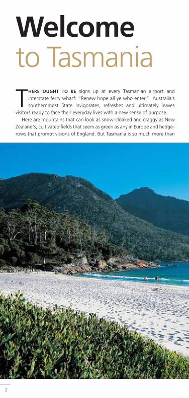
Welcome to TasmaniaTHERE OUGHT TO BE signs up at every Tasmanian airport and
interstate ferry wharf: “Renew hope all ye who enter.” Australia’s southernmost State invigorates, refreshes and ultimately leaves
visitors ready to face their everyday lives with a new sense of purpose.Here are mountains that can look as snow-cloaked and craggy as New
Zealand’s, cultivated fi elds that seem as green as any in Europe and hedge-rows that prompt visions of England. But Tasmania is so much more than
a copy of somewhere else. Here we have some of the world’s cleanest air.Here are vibrant, compact cities – with small-town friendliness butmetropolitan culture – breathtaking natural scenery and beautifullypreserved remnants of human history. Here are people united by theirdesire to dwell amid such artless grandeur and poignant memories.
For visitors attracted to the outdoors, especially bushwalkers, Tasmaniais without peer. Despite its compact size (roughly 300 km north–southand east–west) it has more than 2000 km of major walking tracks, manyof them multi-day walks that traverse sections of the Tasmanian WildernessWorld Heritage Area (WHA). The WHA covers 13,838 sq. km – about one-fi fth of the State – and is one of only three remaining temperate wildernessareas in the Southern Hemisphere. It protects lonely coastlines, tracts ofrainforest barely penetrable by humans, raging rivers such as the Franklinand spectacular peaks such as Cradle Mountain and Frenchmans Cap.
The sum of these parts is an island of wild beauty that lingers foreverin memory. Fill your rucksack and join adventurous spirits from around theworld in Tasmania for your own unforgettable natural experience.
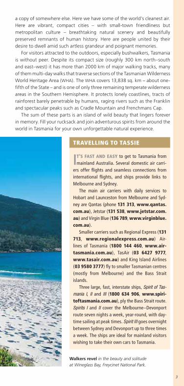
TRAVELLING TO TASSIE
IT’S FAST AND EASY to get to Tasmania frommainland Australia. Several domestic air carri-
ers offer fl ights and seamless connections frominternational fl ights, and ships provide links toMelbourne and Sydney.
The main air carriers with daily services toHobart and Launceston from Melbourne and Syd-ney are Qantas (phone 131 313, www.qantas.com.au), Jetstar (131 538, www.jetstar.com.au) and Virgin Blue (136 789, www.virginblue.com.au).
Smaller carriers such as Regional Express (131713, www.regionalexpress.com.au) Air-lines of Tasmania (1800 144 460, www.air-tasmania.com.au), TasAir (03 6427 9777,www.tasair.com.au) and King Island Airlines(03 9580 3777) fl y to smaller Tasmanian centres(mostly from Melbourne) and the Bass Straitislands.
Three large, fast, interstate ships, Spirit of Tas-mania I, II and III (1800 634 906, www.spiri-toftasmania.com.au), ply the Bass Strait route.Spirits I and II cover the Melbourne–Devonportroute seven nights a week, year-round, with day-time sailing at peak times. Spirit III goes overnightbetween Sydney and Devonport up to three timesa week. The ships are ideal for mainland visitorswishing to take their own cars to Tasmania.
Walkers revel in the beauty and solitudeat Wineglass Bay, Freycinet National Park.
3

4
The bestof TasmaniaTASMANIA may be Australia’s foremost bushwalking destination, but
there’s so much more for visitors to see and do. There’s a range ofoutdoor adventures to try in stunningly beautiful locations; peaceful
pursuits such as fi shing and golf; and some of Australia’s fi nest wines andfreshest food to savour. Come for a long walk, but sample some of Tasmania’sother treats while you’re here.
■ FOR ADVENTUROUS SPIRITSRiver rafting, sea kayaking, rock-climbing: Tasmania has it all. Which one tochoose? Rock-climbing is very popular as Tasmania’s beautiful dolerite andgranite formations offer a feast of climbing at all levels. Popular, accessibleclimbing sites include the Organ Pipes at Mt Wellington, near Hobart,Cataract Gorge in Launceston and Whitewater Wall and The Hazards atFreycinet National Park.
You’ll fi nd contact details for commercial guides offering rock-climbingand many other adventures at www.discovertasmania.com.au > thingsto do and see > outdoor adventure and at www.tasadventures.com.
OUTDOOR GUIDES
AS WELL AS GUIDES for specifi cwalks or activities, Tasmania
offers professional guides who canlead you on a multi-day potpourri ofactivities, including rafting, climbing,kayaking and walking. One of thelongest-running organisations is theLaunceston-based Tasmanian Expedi-tions. Its fl agship trips are FranklinRiver rafting journeys, but the com-pany also offers several walking trips(including all the classic tracks), cycletours on quiet back roads, sea kayak-ing in pristine Bathurst Harbour andPort Davey, and half- and full-dayrock-climbing. For more informationphone 1300 666 856 or 03 63393999 or go to www.tas-ex.com.
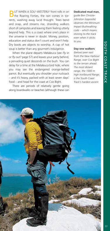
Guide Ben Christie-Johnston atOsmiridium Beach, South Coast Track.

5
■ HISTORY AND HERITAGENo other Australian State has history as tangible as Tasmania’s.
The island’s thousands of years of Aboriginal occupation are marked by countless middens, hut depressions, rock shelters, caves, petroglyphs (carvings) and other sites. Many are accessible only on foot, affording walkers opportunities to see Aboriginal artefacts and relics at their best – in their original setting and context. Some Tasmanian walks – notably the South Coast Track – follow ancient Aboriginal trading routes.
Rock history. Spectacular relics such as these Permian-era marine creatures at Maria Island’s Fossil Cliffs are a common sight on Tasmanian bushwalks.
6
Convict days are best remembered at Port Arthur (www.portarthur.org.au), just a skip from the Tasman Coastal Trail (see map page 30). Other signifi cant convict-era ruins are found on the east coast at Maria Island (page 12), in the west at Sarah Island, and at Ross and Richmond.
In Hobart, Launceston and dozens of smaller centres you’ll fi nd buildings and streetscapes that survive from the earliest years of Van Diemen’s Land – sights that are mostly removed from landscape and memory on mainland Australia.
For more information about historical places to visit go to www.discovertasmania.com.au > things to do and see > history and heritage. For in-depth background try www.tas.gov.au/tasmaniaonline > history and genealogy.
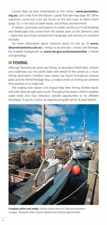
■ FISHINGAlthough Tasmania has great sea fi shing, its abundant inland lakes, streams and waterways put the island State well ahead of the school as a trout-fi shing destination. Excellent trout waters are found throughout national parks and the World Heritage Area, so walkers keen on fi shing can combine their passions on a single trip.
The angling main season runs August–May (best fi shing October–April), and a few lakes are open year-round. Throughout the season, shifts in weather, water levels and trout behaviour provide opportunities to try different techniques. If you’re a novice, an experienced guide will be of great benefi t.
Craypots piled and ready, fi shing vessels moor at Triabunna between voyages. Tasmania offers superb seafood and fi shing opportunities.

Licences are required to fi sh all inland waters (except private fi sheries).A one-day licence is less than $20 and it’s only $50–60 for the full season.Licences are available from more than 120 agents around the State, includingmost tackle shops. Tackle shop assistants will also advise about inland fi shingregulations (such as minimum legal sizes, bag limits and closed seasons oncertain species and waters), where to fi sh and what gear to use.
The Fish Online site (www.fi shonline.tas.gov.au) is the best startingpoint for information about angling in Tasmania. For additional informationabout fi shing and contacts for accommodation and professional guides goto www.troutguidestasmania.com.au.
■ FOOD AND WINEOnce known mainly for its apples, Tasmania has been transformed in recentyears into a gourmet’s Treasure Island. A clean environment and favourableclimate are mainstays of superb local produce – the freshest fruit andvegetables, peerless cheeses, tender meats and superb seafood. Look forTasmanian specialties such as crayfi sh, scallops and abalone. Try leatherwoodhoney on your morning toast.
In season, travel the Huon and Tamar valleys and select delectably freshfruit and berries from roadside stalls. Or visit Hobart’s Salamanca Market –open every Saturday – for fresh vegies.
Locally made pinot noirs and rieslings are rated among Australia’s bestand the vineyards that produce them are a pleasure to visit. The Tamar Valleywine country is fast becoming one of Tasmania’s leading visitor attractions.
The annual Taste of Tasmania Festival is held just after Christmas eachyear on Hobart’s waterfront.
Go to www.discovertasmania.com.au > things to do and see > wineand food to download cellar-door guides to Tasmania’s wine and foodregions. For more information about the Tamar Valley go to www.valleyofthesenses.info.
■ MORE INFORMATIONThe offi cial Tourism Tasmania website (www.discovertasmania.com.au)is a great starting place for information about everything there is to see anddo in Tasmania. You can phone 1800 806 846 (free call from anywhere inAustralia) to request information. See page 64 for more Tasmanian travelcontacts.
7
TASMANIA’S GREATEST HITS
IN AND NEAR HOBART, the weekly Salamanca Market, Cadbury ChocolateFactory, Cascade Brewery, River Derwent cruises and Mt Wellington are top of
the pops. Cataract Gorge pulls in Launceston guests, and the city is gateway tothe Tamar Valley wine route. Port Arthur Historic Site, on the Tasman Peninsula,is the runaway leader among built-heritage sites. Visitors interested in naturalattractions make tracks mostly to Cradle Mountain, the Freycinet Peninsula,Lake St Clair and Russell Falls at Mt Field National Park. The most popularoutdoor experiences include the Tahune AirWalk, cruises on the Gordon River(from Strahan) and the West Coast Wilderness Railway, between Queenstownand Strahan.
8
BushwalkingpreparationPLANNING AND PREPARATION for any extended bushwalk should begin
many months ahead of departure date. The walks described in this guidebook are arduous undertakings in regions subject to changeable
– and sometimes dangerous – weather conditions, and relatively isolated from emergency services. The Tasmanian Parks and Wildlife Service’s EssentialBushwalking Guide & Trip Planner is an excellent starting point when plan-ning a walk; it’s available at PWS offi ces or online at www.parks.tas.gov.au/recreation/mib.html.
■ GET INTO SHAPEIf it’s your fi rst experience of multi-day walking, you’ll need to train. Start with short day-walks with a light daypack and build up to at least one fully laden overnight walk. A decent amount of training should reduce the risk of knee and ankle injuries and will speed your ‘settling-in’ period once you’re on the track.
■ WHAT TO EXPECTAlthough they may be arduous, the walks in this booklet aren’t extreme. All follow established tracks, many of which have had extensive improvements over the years.
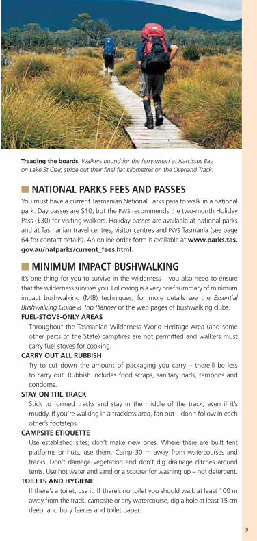
The great unknown is the Tasmanian weather, which can change an easy walk into an extremely tiring one. You must be prepared for all types of weather conditions and – especially on the Overland and South Coast tracks – ensure everything is waterproof.
■ TRACK NOTES, MAPS AND GUIDESThis guidebook is an introduction to overnight walks in Tasmania and isn’t intended for use as your only track notes or walking maps. Australian Geographic strongly recommends walkers obtain the TASMAP sheet maps with track notes that cover each of the walks (these maps generally cover the national park in which the walk is found). Each sheet sells for $9–10. The maps are widely available at map suppliers and outdoor shops, or you can order direct from TASMAP (phone 03 6233 7741, email [email protected]). For information online go to www.dpiwe.tas.gov.au > Property, Titles and Maps > TASMAP.
There are several published guides with extensive track notes covering Tasmanian walks. Among the best known are: Cradle Mountain Lake St Clairby John Chapman and John Siseman, South West Tasmania by John Chapman, and 100 Walks in Tasmania by Tyrone Thomas. John and Monica Chapman’s Bushwalking in Australia and Lonely Planet’s Walking in Australia both contain Tasmanian walks.
■ NATIONAL PARKS FEES AND PASSESYou must have a current Tasmanian National Parks pass to walk in a national park. Day passes are $10, but the PWS recommends the two-month Holiday Pass ($30) for visiting walkers. Holiday passes are available at national parks and at Tasmanian travel centres, visitor centres and PWS Tasmania (see page 64 for contact details). An online order form is available at www.parks.tas.gov.au/natparks/current_fees.html.
■ MINIMUM IMPACT BUSHWALKINGIt’s one thing for you to survive in the wilderness – you also need to ensure that the wilderness survives you. Following is a very brief summary of minimum impact bushwalking (MIB) techniques; for more details see the EssentialBushwalking Guide & Trip Planner or the web pages of bushwalking clubs.FUEL-STOVE-ONLY AREAS
Throughout the Tasmanian Wilderness World Heritage Area (and some other parts of the State) campfi res are not permitted and walkers must carry fuel stoves for cooking.
CARRY OUT ALL RUBBISHTry to cut down the amount of packaging you carry – there’ll be less to carry out. Rubbish includes food scraps, sanitary pads, tampons and condoms.
STAY ON THE TRACKStick to formed tracks and stay in the middle of the track, even if it’s muddy. If you’re walking in a trackless area, fan out – don’t follow in each other’s footsteps.
CAMPSITE ETIQUETTEUse established sites; don’t make new ones. Where there are built tent platforms or huts, use them. Camp 30 m away from watercourses and tracks. Don’t damage vegetation and don’t dig drainage ditches around tents. Use hot water and sand or a scourer for washing up – not detergent.
TOILETS AND HYGIENEIf there’s a toilet, use it. If there’s no toilet you should walk at least 100 m away from the track, campsite or any watercourse, dig a hole at least 15 cm deep, and bury faeces and toilet paper.
9
Treading the boards. Walkers bound for the ferry wharf at Narcissus Bay, on Lake St Clair, stride out their fi nal fl at kilometres on the Overland Track.
10
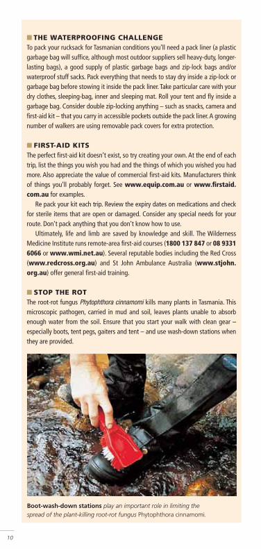
Boot-wash-down stations play an important role in limiting the spread of the plant-killing root-rot fungus Phytophthora cinnamomi.
■ THE WATERPROOFING CHALLENGETo pack your rucksack for Tasmanian conditions you’ll need a pack liner (a plastic garbage bag will suffi ce, although most outdoor suppliers sell heavy-duty, longer-lasting bags), a good supply of plastic garbage bags and zip-lock bags and/or waterproof stuff sacks. Pack everything that needs to stay dry inside a zip-lock or garbage bag before stowing it inside the pack liner. Take particular care with your dry clothes, sleeping-bag, inner and sleeping mat. Roll your tent and fl y inside a garbage bag. Consider double zip-locking anything – such as snacks, camera and fi rst-aid kit – that you carry in accessible pockets outside the pack liner. A growing number of walkers are using removable pack covers for extra protection.
■ FIRST-AID KITSThe perfect fi rst-aid kit doesn’t exist, so try creating your own. At the end of each trip, list the things you wish you had and the things of which you wished you had more. Also appreciate the value of commercial fi rst-aid kits. Manufacturers think of things you’ll probably forget. See www.equip.com.au or www.fi rstaid.com.au for examples.
Re pack your kit each trip. Review the expiry dates on medications and check for sterile items that are open or damaged. Consider any special needs for your route. Don’t pack anything that you don’t know how to use.
Ultimately, life and limb are saved by knowledge and skill. The Wilderness Medicine Institute runs remote-area fi rst-aid courses (1800 137 847 or 08 9331 6066 or www.wmi.net.au). Several reputable bodies including the Red Cross (www.redcross.org.au) and St John Ambulance Australia (www.stjohn.org.au) offer general fi rst-aid training.
■ STOP THE ROTThe root-rot fungus Phytophthora cinnamomi kills many plants in Tasmania. This microscopic pathogen, carried in mud and soil, leaves plants unable to absorb enough water from the soil. Ensure that you start your walk with clean gear – especially boots, tent pegs, gaiters and tent – and use wash-down stations when they are provided.

Packing checklistWHATEVER TIME OF YEAR you walk you must be prepared for all
conditions. But take care not to overload. Most walkers are comfortable with a pack that weighs between one-fi fth and one-third of their body weight, depending on their level of fi tness.
ESSENTIAL■ Rucksack■ Pack liner■ Tent (built-in fl oor essential),
poles and pegs■ Sleeping mat■ Sleeping-bag■ Inner sheet (silk inners are
light and compact)■ Map■ Compass
■ Boots■ Gaiters■ Socks (2 pr minimum)■ Rain jacket■ Waterproof overpants■ Walking clothes (including
thermal layers)■ Dry set of clothes■ Fleece or down jacket■ Camp shoes (sandals)■ Sunhat■ Beanie■ Gloves
■ Sunglasses■ Sunscreen
■ Toothbrush and paste (and any other personal toiletries you can’t live without)
■ Torch and batteries■ Toilet paper and lightweight
trowel■ First-aid kit■ Whistle
■ Water container■ Meals and snacks■ Fuel stove and fuel■ Pots, plates/bowls and cutlery■ Waterproof matches and
butane lighter■ Zip-top plastic bags■ Length of light cord or rope
OPTIONAL■ Camera, spare fi lm/memory
cards and batteries■ Notebook and pencil■ Books/fi eld guides■ Playing cards (or other
lightweight entertainment)■ EPIRB■ GPS■ Satellite phone
11
■ THE WALKERS’ ONE-STOP SHOPOne of Tasmania’s newest guiding outfi ts, Tasmanian Wilderness Experiences (TWE), offers an all-in-one service. They’ll collect you from the airport (or anywhere else) and take you back to their bush-haven accommodation (Base Camp Tasmania) at Glenfern near Hobart. During an overnight stay you’ll be fed and set up to walk with almost everything except a pair of boots. They’ll transport you to your walk, provide guides if you wish, and return you to Base Camp for another night to shower, return gear and have another tasty meal. To top it off, TWE offers 16 guided walks of three to nine days’ duration. Call 03 6261 4971, 1300882 293 or see www.bctas.com.au for more information.

Cool at the top.Guide Hanny Allstongazes over GreatOyster Bay fromBishop and Clerk’s599 m summit, thedolerite spires thatcrown Maria Island’snorth-eastern fl ank.

MARIA ISLAND looms off Tasmania’s east coast like acraggy shadow, distant and mysterious. The steep
mountains that dominate its more visible, larger, northernpart – their peaks often shrouded in cloud – appear to risealmost straight out of Mercury Passage. The northern partof Maria is about 10–15 km offshore, suffi ciently distantfor fi rst views to tantalise and entice.
Once you find out a little more about the island, a tripto the East Coast to catch the ferry will be irresistible.There are Maria’s remarkable fossil beds, the breathtakingviews from its soaring peaks, its quiet forests and the his-torical buildings around Darlington settlement. Enticingextras are the abundant native animals – Maria has beena national park since 1972 – and solitude.
Maria IslandISLAND OF HISTORY
MA
RIA
ISL
AN
D
13
▲
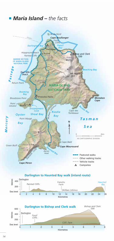
■ Maria Island – the facts
14
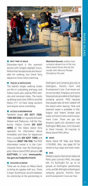
Mainland bound, walkers load rucksacks aboard one of the two Maria Island ferries that ply the usually calm Mercury Passage throughout the year.
■ BEST TIME TO WALK
December–April is the warmest period with longest daylight hours. Mild winter temperatures are favour-able for walking, but check ferry departure times when plan ning.
■ TRACKS & DIFFICULTIES
The island’s longer walking routes are fl at or undulating and easy, and follow tracks also used by PWS vehi-cles and mountain bikes. The tracks up Bishop and Clerk (599 m) and Mt Maria (711 m) have steep sections and require some scram bling.
■ ACCESS & INFORMATION
Tassielink buses (03 6271 7320, 1300 300 520) run regularly between Hobart and Triabunna. Call the Tria-bunna Visitors Centre (03 6257 4090) or the Maria Island ferry operators for information about timetables and fares for departures from Louisville (03 6257 1589) andTriabunna (0427 100 104). The PWS information centre is in the Com -missariat Store, near the Darlingtonjetty. Maria Island PWS phone is: 0362571420; or web: www.parks .tas.gov.au/natparks/maria
■ FACILITIES & WATER
There are no shops on Maria Island so bring all supplies with you. There is basic bunkhouse accom modation(no electricity) at the peni tentiary in
Darlington and cam ping grounds at Darlington, Frenchs Farm and Encampment Cove. Fuel stoves are recom mended. Fire places and some fi rewood are provi ded at Dar lingtoncamping ground. PWS requests that people take all their rubbish off the island when leaving. Tank and reservoir water is avail able in Dar-lington and there’s limi ted tank water at Frenchs Farm and En camp-ment Cove. There are gas hot showers (gold coin dona tion) near Darlington BBQ area. Limit showers to three minutes. All inquiries to Maria Island PWS offi ce.
■ MAPS
Maria Island NP Map and Notes (1:50,000). Also, see page 63 for where to buy maps and track notes.
■ FEES
Walkers need a Tas manian National Parks pass (contact PWS, see page 64). It’s $22/night for up to six people at Darlington penitentiary units, and $4.40/night at Darlington camping ground; Frenchs Farm and Encamp ment Cove are free.
MA
RIA
ISL
AN
D
15

16
KING DIEGO OF DARLINGTON
IN 1884 THE TASMANIAN GOVERNMENT leased Maria Island to entrepreneur Diego Bernacchi. Attracted by the mild climate and good soils, Bernacchi
planted grape vines and mulberry trees and began planning other industries. In1888 he renamed Darlington “San Diego” and launched Maria tourism withthe open ing of the Grand Hotel. Darlington – San Diego – thrived for a time, itspopulation attracting a State school (now the national park offi ce), generalstore, butcher and baker to the island. Unfortunately, the 1890s Depressionscuttled Bernacchi ’s plans, and he left the island after his assets were seized in1896. He returned in 1920 to create a cement industry. The venture neverthrived. Bernacchi died in 1925, before the cement works failed in 1930.
Forester, or easterngrey kangaroos (below)are one of several speciesintro duced to the islandduring the 1960s, whenMaria became a reserve forendangered wildlife. Today,marsupials and birds wanderfreely around the historicDarlington settlement(bottom).

Ile du Nord (above) was the site of a whaling station in the early 1800s. Since 1991, its surrounding waters have been protected in the park’s marine section. It’s now a popular spot for snorkelling and diving.
MARIA ISLAND’S WALKS range from mere strolls near Dar lington settlement, through
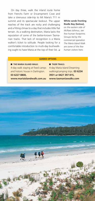
longer but unde manding walks to more distant campgrounds, to fairly testing day walks up the mountains. Although there isn’t a long-estab-lished multi- day track here, if walkers move between the island’s three camping grounds and add several day walks, it’s possible to create a walking program of many days and more than 60 km. The Maria Island Walk’s four-day guided walk (see next page) covers 33–40 km.
Spend a night or two at Darlington camping ground to allow time for visits to historic buildings and to complete the Fossil Cliffs and Bishop and Clerk walks. The Bishop and Clerk track – one of the more demanding on the island – includes steep sections over scree and some scrambling near the 599 m summit, from where there are breath taking views north to Tasmania’s east coast and Freycinet Peninsula.
Plan at least a three-day walk from Darlington. On day one take the undulating coast track south past the Painted Cliffs and set up camp at either Frenchs Farm or Encampment Cove. On day two, take an out-and-back day walk along McRaes Isth-mus and on to Haunted Bay. The track rises on quiet south Maria and leads to sweeping views of the Tasman Sea and Forestier and Tasman penin-sulas. Few people venture down to this part of Maria, and there’s a palpable feeling of isolation.
MA
RIA
ISL
AN
D
17
Brilliant red in rain, the gum-top stringybark (above) is one of Maria’s nine eucalypt species. Although much altered by human activity, the island contains some pristine woodlands.
On day three, walk the inland route homefrom Frenchs Farm or Encampment Cove andtake a strenuous side-trip to Mt Maria’s 711 msummit and its spectacular lookout. The upperreaches of the track are rocky and challengingand a fi tting climax to a day that includes little fl atterrain. As a walking destination, Maria lacks thereputation of some of the better-known Tasma-nian tracks. That lack of recognition is a Mariawalker’s ticket to solitude. People looking for acom fortable introduction to multi-day bushwalk-ing ought to have Maria at the top of their list. ❑
■ THE MARIA ISLAND WALK:
4-day walk staying at fi xed campsand historic house in Darl ing ton.03 6227 8800,www.mariaislandwalk.com.au
■ TIGER TRAILS:
4-day Maria Island Dreamingwalking/camping trips. 03 62343931 or 0427 397 815,www.tasmaniawalks.com
GUIDED OPTIONS
White sands frontingRiedle Bay (below),on the eastern side ofMcRaes Isthmus, seefew human footprints.Groups led by thecommercial operationThe Maria Island Walkare some of the fewhuman visitors here.

19
THE MARIA ISLAND WALK
MARIA ISLAND HOSTS one of Tasmania’s newest, most diverse andhistorically absorbing guided walks. The four-day Maria Island Walk
includes a route via beaches and through peaceful forests, accommodation incomfortable standing camps and a historic house, ample time to exploreintriguing Darlington and – this could be the clincher for you – fi ne food andwine. Optio nal side-trips to Mt Maria or Bishop and Clerk aside, the walkingis blissfully undemanding. Guests need only carry personal gear, an innersheet (sleeping-bags are provided) and lunch, so pack weights are low. Thewalk offers several attractions unavailable to independent walkers, includingthe boat passage to McRaes Isthmus, the standing camps’ positions (one onsouth Maria and one near Four Mile Beach) and the chance to stay in DiegoBernacchi’s old house in Darlington. For more information phone 03 62278800 or go to www.mariaislandwalk.com.au.
Crumbling dolerite,a remnant of Jurassic-era molten-rockintrusions, forms ascree slope belowBishop and Clerk’ssummit. Such obstaclesemphasise MariaIsland’s diverse terrain.
MA
RIA
ISL
AN
D
19

Vintage view.Wineglass Bay dazzlesbeneath Mt Amos.Circuit walkers crossMt Freycinet andMt Graham, middledistance, beforetraversing Wineglasson their return toColes Bay.

FR
EY
CIN
ET
PE
NIN
SU
LA
21
▲
▲
FreycinetPeninsulaCircuit BEAUTIFUL BEACHES
& GRANITE PEAKS
AS YOU DRIVE from Hobart to Frey cinet Peninsula on a clear day, the peninsula’s rearing peaks fi rst
appear across the wide expanse of Great Oyster Bay.Further on, The Haz ards – implacable granite lumps thatare Freycinet’s front gate – dominate views. From quietColes Bay, it’s just a few kilometres, past RichardsonsBeach and Honeymoon Bay, to the starting point for theFreycinet Peninsula Circuit.
22
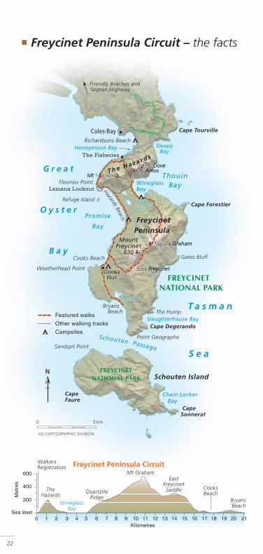
■ Freycinet Peninsula Circuit – the facts
FR
EY
CIN
ET
PE
NIN
SU
LA
23
■ WALKING TIME
2–3 days
■ WALKERS PER YEAR
2500–3000
■ BEST TIME TO WALK
December–April has the warmest average temperatures and longest daylight hours. East-coast winters offer favourable walking conditions, with mild temperatures and less-crowded tracks.
■ TRACKS & DIFFICULTIES
Freycinet Circuit tracks are well formed and easy to follow. PWS pre-fers walkers to travel anti-clock wiseto help stop the spread of Phyto-phthora (see page 10). The sec tionbetween Cooks Beach and Wine -glass Bay includes a long ascent to Mt Graham (579 m). The side-trip up Mt Freycinet (620 m) involves some steep scrambling.
■ MAPS
Freycinet National Park Map and Notes (1:50,000). See page 63 for where to buy maps and track notes.
■ ACCESS & INFORMATION
Tassielink bus service runs regularly between Hobart and the Coles Bay turn-off (ph. 03 6271 7320, 1300 300 520); last leg on Bicheno–Coles Bay bus (03 6257 0293). The PWS
Visitor Centre (03 6256 7000, [email protected]) is just east of Coles Bay. Freycinet Circuit can be found on the web: www.parks.tas.gov.au/re cre a-tion/tracknotes/freycinet.html
■ FACILITIES & WATER
There are walkers’ campsites at Hazards and Cooks beaches and the southern end of Wineglass Bay. There are freshwater streams en route and a hut with limited tank water at Cooks Beach, but the PWS
strongly recommends that walkers do not rely on these water sources. This is a fuel-stove-only area. Carry out all rubbish.
The main camping ground at Richardsons Beach has a walkers’ camping area. You must book ahead if you're walking during the busy Christ mas/New Year and Easter periods. All bookings and inquiries to PWS Visitor Centre.
■ FEES
Walkers must have a current Tas-manian National Parks pass (contact PWS, see page 64). Adults $5.50/night at Richard sons Beach camping ground; wal kers’ camp-sites free.
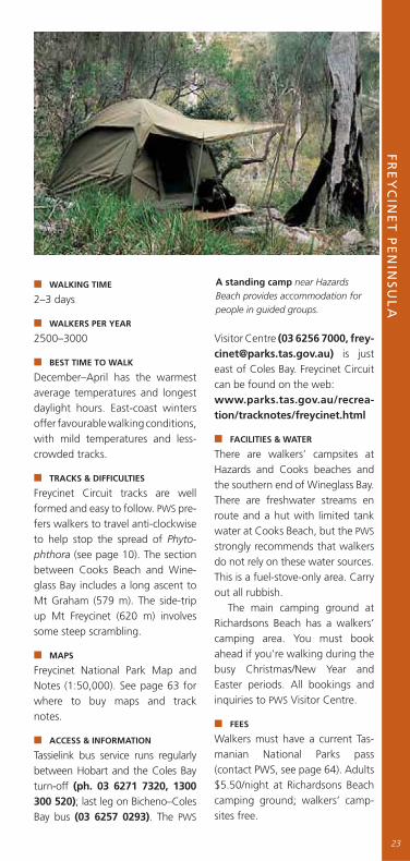
A standing camp near HazardsBeach provides accommodation forpeople in guided groups.
THE FREYCINET CIRCUIT isn’t hard by Tas ma-nian standards, but any climb from sea level
up to 500–600 m elevation deserves respect. It’s possible to do the 30 km circuit in two days but it’s much more enjoyable to do it in three. Avail-ability of drinking water is the big issue. There’s usually – not always – water at Haz ards Beach and Cooks Beach campsites, but it’s scarce at the Wineglass Bay campsite.
From the walker registration point take Hazards Beach Track, which goes fi rst west then south, skirting the base of Mt Mayson and mostly staying in light eucalypt and she-oak forest about 100 m beyond the waterline. Lemana Lookout provides the fi rst clear view south. The 3 km long Hazards Beach and protected seabird colonies of Refuge Island and Promise Rock take up the foreground; Mt Frey-cinet and Mt Graham tower behind in the dis-tance. You’ll walk over those mountains in the next few days.
The campsite at the south end of Hazards Beach is beautifully located amid she-oaks, near the peninsula’s most reliable water source. If you’re out for three days, one alternative is to stop here for the night, enjoy an easy two-hour
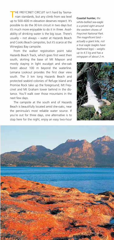
Coastal hunter, thewhite-bellied sea-eagle is a prized sight around the western shores of Freycinet National Park. The magnifi cent bird – actually a giant kite, not a true eagle (eagles have feathered legs) – weighs up to 4.5 kg and has a wingspan of about 2 m.

FR
EY
CIN
ET
PE
NIN
SU
LA
25
THE WINEGLASS HIGHWAY
FREYCINET is one of Tasmania’s most popular national parks with about 160,000 visitors a year, the vast majority of whom will do just one walk.
From the main car park there’s a 1.3 km uphill ramble to a lookout, from which visitors savour views of one of Tasmania’s icons: the brilliant white sand and clear waters of Wineglass Bay.
The Wineglass lookout track is wide and its surface is beaten hard by boot, shoe and sandal. On a sunny Sunday it carries the sort of crowd you’d expect on a city footpath at lunchtime and you give up saying friendly g’days to fellow walkers. Many go no further than the lookout. A fair crowd will continue down to the nor thern end of Wineglass beach for a picnic and swim, and some will march a dis tance up the beach. Then they about-face and head back to the car park. If you’re walking in from the south on the circuit, the bulk of your day will be peaceful and quiet.
walk to Cooks Beach the next morning and take in Bryans Beach as a side-trip that afternoon. That will mean two fairly easy days before the big push over the mountains to Wineglass on day three. If you’re doing the circuit in two days it’s better to push on to Cooks Beach campsite on day one. South of Hazards Beach it’s easy walking, with lovely fi ltered views over Great Oyster Bay. A quiet camp at Cooks is just the tonic before tackling the mountains.
Looming granite peaks called The Hazards guard the northern end of Freycinet Peninsula. The circuit walk begins near the base of 454 m Mt Amos, at right of picture, and follows the bay shore south towards Fleurieu Point.

THE WESTERN SHORE BY WATER
ONE OF THE BEST VIEWS of the granite peaks of The Hazards and Freycinet Peninsula is from the west when the peaks are enveloped in brooding
morning shadow or bathed in fading afternoon sunlight. Problem: immediatelywest of the peninsula is the 15 km wide Great Oyster Bay. Solution: get out onthe water in a Freycinet Adventures sea kayak. The adven ture company’s three-hour Freycinet Paddle, led by an experienced guide, departs Coles Bay eachmorning and evening, year-round. For more information phone 03 6257 0500or go to www.freycinetadventures.com.
Expect to take about fi ve hours to walk fromCooks Beach campsite over the mountains toWineglass Bay campsite. In clear weather thismountain section is magnifi cent. The track windsthrough a mosaic of plant communities – bluegum and lomandra close to the coast; shrubbyheath, silver peppermint gum, Oyster Bay pineand even buttongrass higher up. The views fromhigh points are dramatic – south to Schoutenand Maria islands, and north towards Wineglassand The Hazards. Once past Mt Graham, thetrack’s mostly downhill, with the cooling watersof stunning Wineglass Bay an incentive to keepmoving. From the southern end of Wineglass, it’sonly an hour back to the car park. ❑
Sunset show overGreat Oyster Bay stopswalkers (below) headedfor Hazards Beach Camp,about two hours fromthe walk registrationpoint and the perfectplace to camp if you'veset out mid-afternoon.Next day you’ll continuetowards Cooks Beach,then tackle the climbto 620 m Mt Freycinet(opposite).

FR
EY
CIN
ET
PE
NIN
SU
LA
27
GUIDED OPTIONS
■ FREYCINET ADVENTURES
2-day walking trip and 3- and5-day walking/sea kayak trips;camping and standing campaccommodation. 03 6257 0500,www.freycinetadventures.com
■ FREYCINET EXPERIENCE
4 day-walks in Freycinet NP;accommodation at FriendlyBeaches Lodge. 03 6223 7565or 1800 506 003,www.freycinet.com.au
■ TASMANIAN EXPEDITIONS
3-day Freycinet Tour. 03 63393999 or 1300 666 856,www.tas-ex.com
■ BEYOND WINEGLASS
3-night boat/walking trip,1 night camping and 2 atFreycinet Lodge. 03 6257 0101,www.freycinetlodge.com.au
■ TASMANIAN WILDERNESSEXPERIENCES
3-day Freycinet Circuit Tour.03 6261 4971,1300 882 293 or0414 238 458www.bctas.com.au
■ TIGER TRAILS
3-day Peninsula Circuit walking/camping trip. 03 6234 3931or 0427 397 815,www.tasmaniawalks.com

Imposing cliffs suchas these near Devils Kitchen provide staple views along the Tasman Coastal Trail. The track winds south from here to spect acular Cape Hauy and Cape Pillar.

TA
SM
AN
CO
AS
TA
L T
RA
IL
▲
Coastal Trail
TheTasman
THE TASMAN PENINSULA is a place where landform,ocean, climate and isolation conspire to fashion a
coastal landscape that inspires awe and even fear. Onlywalkers can reach special places on the peninsula thatmagnify its beauty and grandeur.
The Tasman Coastal Trail follows the peninsula’s east-ern coastline from Waterfall Bay, near Eaglehawk Neck,to Cape Pillar. It climbs peaks, skirts soaring cliffs androunds tranquil bays. It passes through tall eucalypt for-est, temperate rainforest and coastal heath.
WINDSWEPT CLIFFS& WILD VIEWS
29

■ Tasman Coastal Trail – the facts
30

TA
SM
AN
CO
AST
AL
TR
AIL
31
■ DISTANCE
45 km
■ WALKING TIME
3–5 days
■ WALKERS PER YEAR
Full length of trail: 100Waterfall Bay–Fortescue Bay only: 500Fortescue Bay–Cape Pillar via Mt Fortescue: 300Fortescue Bay–Cape Pillar via Snake Hill: 350
■ BEST TIME TO WALK
December–April have the warmest average temperatures and longest daylight hours; January–March are the driest months; annual rainfall here is about 230 mm higher than at Maria Island or Freycinet. If parti-cularly severe winds are forecast for the Cape Pillar area it’s advisable to delay departure.
■ TRACKS & DIFFICULTIES
Tasman Trail tracks are mostly well formed and easy to follow. There are long ascents up Tatnells Hill (571 m) and Mt Fortescue (490 m). The track over Mt Fortescue passes through a wet forest and is steep and slippery in sections. Great cau tion must be exercised at cliff-top areas, partic-ularly around capes Hauy and Pillar.
■ MAPS
Tasman National Park Map and Notes (1:75,000). See page 63 for where to buy maps and track notes.
■ ACCESS & INFORMATION
Tassielink buses (03 6271 7320, 1300 300 520) run regularly on weekdays between Hobart and Eaglehawk Neck. Private transport is required to and from Fortescue Bay camping ground. Tasman NP is managed from the PWS’s Seven Mile Beach offi ce (03 6214 8100).
Hurricane Heath is the campsite nearest Cape Pillar that provides shelter from raking winds. From here walkers journey east to the spectacular, exposed clifftop sites that characterise the park.
Tas man Trail on the web: www.parks.tas.gov.au/recreation/track notes/tasman.html
■ FACILITIES & WATER
There are walkers, campsites at Water fall Bay, Bivouac Bay, Wug-halee Falls, Bare Knoll and Hurricane Heath. The freshwater streams en route aren’t reliable. PWS suggests that walkers have a large water-carrying capacity and refi ll at every opportunity. This is a fuel-stove-only area. Carry out all rubbish.
The main camping ground at Fortescue Bay is very popular and you should book ahead if walking during the busy November–New Year and Easter periods. All book-ings and inquiries to the resident manager (03 6250 2433).
■ FEES
All walkers must have a Tas manianNational Parks pass (contact PWS,see page 64). Tent sites $5.50/oneadult, $11/two or more, at Fort es-cue Bay cam ping ground; walkers’ campsites are free.
HARDY SPECIMEN
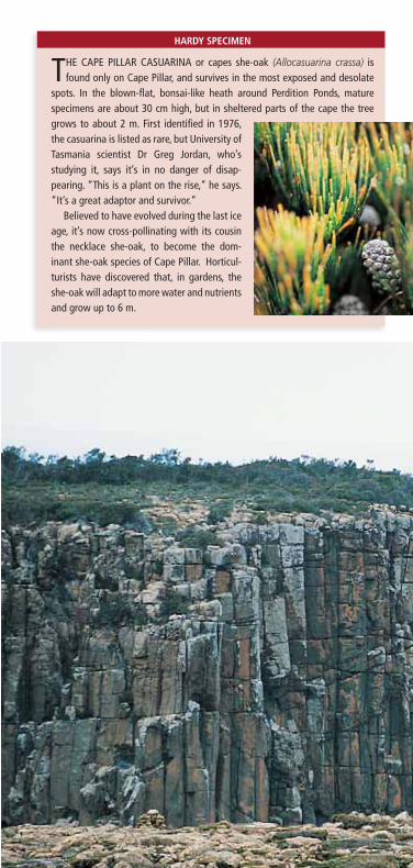
THE CAPE PILLAR CASUARINA or capes she-oak (Allocasuarina crassa) is found only on Cape Pillar, and survives in the most exposed and deso late
spots. In the blown-fl at, bonsai-like heath around Perdition Ponds, mature specimens are about 30 cm high, but in sheltered parts of the cape the tree grows to about 2 m. First identifi ed in 1976, the casua rina is listed as rare, but Uni versity of Tas mania scientist Dr Greg Jordan, who’s study ing it, says it’s in no danger of disap -pearing. “This is a plant on the rise,” he says. “It’s a great adaptor and sur vivor.”
Believed to have evolved during the last ice age, it’s now cross-polli nating with its cousin the neck lace she-oak, to become the dom-inant she-oak species of Cape Pillar. Horti cul-turists have discovered that, in gardens, the she-oak will adapt to more water and nutrients and grow up to 6 m.

VIEWS AND VERTIGO
THE TASMAN COASTAL TRAIL is bestavoided if you suffer from vertigo. A
label on the Tasman National Park mapsays it all with delicious under statement.“Caution: Along parts of the TasmanCoastal Trail you will be exposed tounfenc ed hazardous cliff edges.”
Beyond Perdition Ponds on Cape Pillaryou’ll have the best chance to come toterms with “unfenced” and “hazar-dous”. Here are Australia’s highest ver-tical sea-cliffs: crumbling dolerite col-umns that spear down to a cold andunforgiving ocean. Winds funnel up thecliffs to reach a pummelling velocity atthe top; on occasions walkers have liter-ally been blown off their feet. In parts,the track hugs the top of the cliffs,sometimes just a step or two from a200 m drop.
Weathered dolerite(below) rises morethan 200 m above theTasman Sea in partsof Cape Pillar. Viewshere seem even moredra matic in the rava gingwinds. At the exposedheath near PerditionPonds, plants such asthe Cape Pillar casuarina(opposite) have adaptedby growing low amongthe rocks. Elsewhereon the peninsula, thespecies reaches 2 m.
TA
SM
AN
CO
AS
TA
L T
RA
IL
COMPOSED OF COLD, grey dolerite (see Rock of Tassie, page 44), the peninsula’s eastern
cliffs have been worn into spectacular shapes –islets, towers, arches, caves and cliffs. Cape Pillar,the south-eastern extremity, is fully exposed tothe fury of southern storms and its features havenames that leave no doubt about what to expect:Tornado Ridge, Purgatory Hill, Corruption Gully,Hurri cane Heath.
A night spent at Cape Pillar in bad weather isboth unnerving and utterly compelling. Squallsdrift in off the ocean like waves. The wind gushesthrough euca lypt and heath with a scouring soundthat gathers strength, rising like a crashing brea-ker. Then the rain comes in great wet gobs, sha-king the tent fl y and drowningout the wind. You lie snug inyour sleeping-bag, wonder ingwhat daylight will bring.
33


Patches of wet eucalypt forest (left),such as this near Bare Knoll, providecool, shady breaks from the coastalheath that predominates around CapePillar. Tracks are generally well marked,but a map (below) should still beconsidered essential.
TA
SM
AN
CO
AS
TA
L T
RA
IL
■ TASMANIAN WILDERNESS EXPERIENCES
3-day Tasman Coastal Trail walking/camping tour, Fortescue Bay to CapePillar. 03 6261 4971, 1300 882 293 or0414 238 458, www.bctas.com.au
GUIDED OPTIONS
Whatever the weather, the splendour of thearea is undiminished. From the cliffs overlookingClytie Bight, it’s a dizzying 200 m drop to theocean (see Views and vertigo, page 33). Lichensspread in delicate blooms on the dolerite. Rain-drops fl atten into the cliff with a smack that shat-ters them into vapour, which is then torn by theupdraught over and away into the heath.
Surprisingly, the Tasman Coastal Trail is some-thing of a hidden jewel because the peninsula isknown almost exclusively as the home of PortArthur, Australia’s best-known remnant of theconvict era and one of Tasmania’s most visitedsites. The ruins are a short drive west of theTasman Coastal Trail, but few of the people thatmake the 90-minute journey from Hobart to PortArthur are inclined to walk the track. They wouldif they knew what they were missing. ❑
35

Bearing south, theOverland Track passes Crater Lake, Cradle Mountain and, in the distance at top right, Barn Bluff, fi nishing at Lake St Clair.
▲
37
OV
ER
LA
ND
TR
AC
K
37
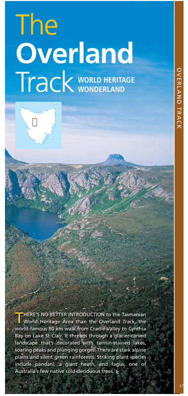
THERE’S NO BETTER INTRODUCTION to the TasmanianWorld Heritage Area than the Overland Track, the
world-famous 80 km walk from Cradle Valley to CynthiaBay on Lake St Clair. It threads through a glacier-carvedlandscape that’s decorated with tannin-stained lakes,soaring peaks and plunging gorges. There are stark alpineplains and silent green rainforests. Striking plant speciesinclude pandani, a giant heath, and fagus, one ofAustralia’s few native cold-deciduous trees.
WORLD HERITAGEWONDERLAND
TheOverlandTrack

■ The Overland Track – the facts
38

OV
ER
LA
ND
TR
AC
K
39
■ LENGTH
80 km, 65 km to Lake St Clair
■ WALKING TIME
5–7 days (longer if taking more side-trips)
■ WALKERS PER YEAR
8500–9000
■ BEST TIME TO WALK
December–March is the busiest time. Walkers starting from Novem-ber–April must book a departure day in advance and may only travel north–south (see Booking Over landtime, page 43). From May to Octo -ber there are fewer people on the track and you may walk in either direction. Only very experienced walkers are advised to set out in mid-winter, when daylight hours are short and driving rain and snow are likely.
■ TRACK & DIFFICULTIES
Extensive maintenance and track har dening has transformed the Overland in recent decades. Some muddy sections remain, but the track is well formed and easy to fol-low. The steepest climbs are those up to the Cradle Plateau and on the side-trips to Cradle Mountain summit, Barn Bluff and Mt Ossa.
■ MAPS & NOTES
Cradle Mountain - Lake St Clair Map and Notes 1:100,000 (TASMAP). TheOverland Track – A Wal ker’s Note-book (PWS). See page 63 for where to buy maps and track notes.
■ ACCESS & INFORMATION
Tassielink (03 6271 7320, 1300 300 520) runs bus services to/from Cradle Mountain and Lake St Clair year-round (more frequently in sum-mer and autumn). A ferry runs between Narcissus and Cynthia bays on Lake St Clair (03 6289 1137 for bookings/timetables). The PWS Cra-dle Mountain (03 6492 1133, [email protected]) and Lake
St Clair (03 6289 1172) offi ces are best for information. Cradle Moun-tain Visitor Centre (03 6492 1110)can assist with accom modation at the walk’s northern end. Over landTrack on the web: www.overlandtrack.com.au, www.parks.tas.gov.au/recre ation/tracknotes/overland.html
■ FACILITIES & WATER
Huts at Waterfall Valley, Lake Wind-ermere, Pelion Plains, Kia Ora, Windy Ridge and Narcissus are available on a fi rst-come, fi rst-served basis; wal kers using them must have their own food, cooking utensils, fuel stoves and bedding. Do not rely on huts for accom -modation. Carry tents and fuel stoves in case huts are full or you need to stop because of poor weather, injury or fatigue. PWS
prefers campers to pitch tents near huts, and to use tent platforms where they are provi ded. There are composting toi lets at all hut sites. Water is plen tiful in creeks along the route and in tanks at huts.
■ FEES
Walkers must have a valid Tas ma-nian National Parks pass (contact PWS, see page 64). An additional facility fee is pay able during the booking season (see BookingOverland time, page 43).
Superb huts including New Pelion (above) – the ‘Pelion Palace’ – provide overnight shelter at several points along the track. Walkers, however, must still carry tents.

SIDE-TRIPS
THE CRADLE MOUNTAIN–LAKE ST CLAIR region’s best views are from side-tracks, which most walkers regard as essential, not optional. Some side-tracks
retain the wet and muddy rusticity now largely absent from the much-improvedmain track. Weather is the biggest infl uence on which side-tracks you shouldattempt. The mountain summits are best avoided in poor conditions and youmust carry all cold- and wet-weather gear – even if you set out in perfect weather.If the weather holds, attempt every side-track you can. The highlights are:
■ CRADLE MOUNTAIN SUMMIT (1545 M)
The track goes east off the main trackjust south of Kitchen Hut. It’s a steepclimb over scree. Allow three hoursreturn.
■ BARN BLUFF (1559 M)
About halfway along Cradle Cirquethis track goes west. It’s an easierascent than Cradle Mountain but veryexposed on Barn Cirque. Allow 2–3hours return.
■ LAKE WILL
The track goes west about 4 kmnorth of Lake Windermere. The trackpasses 19th-century coal-miningworks on its way to the lake, a quietand picturesque alpine tarn. Allow 1.5hours return.
■ MT OSSA (1617 M)
Tasmania’s highest point. The trackgoes west at Pelion Gap (1126 m). Thegoing is steep to Mt Doris, and there’ssome scrambling towards the Ossasummit. Allow 3–4 hours return.
■ D’ALTON AND FERGUSSON FALLS
The track goes east and descendssteeply through rainforest to theMersey River. Unlike the mountainsummits, bad weather doesn’t marthe view of either falls. Allow 1–2hours return.
■ HARTNETT FALLS
The track goes east and gently down-hill to Hartnett, the highest of theMersey River’s falls. Allow about 45minutes return.
OV
ER
LA
ND
TR
AC
K
41
W EATHER usually dominates any walker’s fi rst impressions of the Overland, parti-
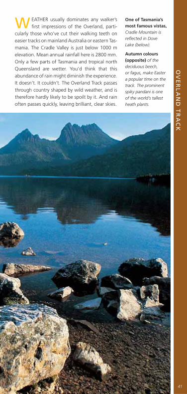
cularly those who’ve cut their walking teeth on easier tracks on mainland Australia or eastern Tas-mania. The Cradle Valley is just below 1000 m elevation. Mean annual rainfall here is 2800 mm. Only a few parts of Tas mania and tropical north Queensland are wetter. You’d think that this abundance of rain might di minish the experience. It doesn’t. It couldn’t. The Overland Track passes through country shaped by wild weather, and is therefore hardly likely to be spoilt by it. And rain often passes quickly, leaving brilliant, clear skies.
One of Tasmania’s most famous vistas,Cradle Mountain is refl ected in Dove Lake (below).
Autumn colours (opposite) of the deciduous beech, or fagus, make Easter a popular time on the track. The prominent spiky pandani is one of the world’s tallest heath plants.


The track includes some of Australia’s most loved wilderness views: Crater Lake and its steep, fagus-draped surrounds, which blaze gold and red in autumn; Dove Lake extending like a mirror below Cradle Mountain’s crumbling dolerite towers; Barn Bluff rising above the seemingly impen etrable depths of Fury Gorge; Mt Ossa, Tas mania’s highest mountain; and Lake St Clair, Aus tralia’s deepest freshwater lake.
Temperate rainforest often envelops the track, which passes many moss-lined waterfalls, such as this one (left) on a Mersey River tributary. The Overland crosses Pine Forest Moor (above) then fl anks spectacular 1560 m Mt Pelion West, background, Tasmania’s second-highest mountain, en route to Frog Flats.
FROM NOVEMBER 2005 a system of controlled departures will operate on the Overland Track during the peak season (November–April). You can
reserve your peak-season depar ture date via the online booking system (www.overlandtrack.com.au), which is expected to open in June 2005. The booking system aims to relieve overcrowding at huts and camping areas and to reduce environmental impact. Both measures will enhance walkers’ experience. About 75–80 per cent of people who walk the track each year depart during peak season, with Christmas and Easter holidays the busiest periods. Before the book ing system, up to 140 walkers started on the same day. Under the new system, daily departure numbers will be limited to around 50 per day and all walkers will travel north to south. Maximum size for groups (independent and commercial) will be 13 and all large groups will be in tents, in clearly signposted group camping areas. Huts will be the domain of independent walkers, alone, or in small parties, but hut accom modation will still be on a fi rst-come basis so, as always, all walkers must carry their own tents. Under the booking system, peak-season walkers will pay a fee in addition to their park-entry fee. You can pay for both when booking.
OV
ER
LA
ND
TR
AC
K
43
BOOKING OVERLAND TIME
▲

Crumbling dolerite columns defi ne most of the Overland’s shadowing peaks. Top target for most walkers is 1617 m Mt Ossa (above), Tas mania’s highest point, which is accessible in fair weather via a steep side-track. Generally the walking isn’t diffi cult. The hardest scramble on the main track (opposite) is above Crater Lake to Marions Lookout.
ROCK OF TASSIE
DOLERITE, sometimes called bluestone, covers about 40 per cent of Tasmania and forms the
distinctive, columnar appearance of most of its best- known geological features, including Cradle Mountain, Mt Ossa, Mt Wellington and the sea cliffs of the Tasman Peninsula. Dolerite isn’t found on mainland Australia, and is one of the geological links between Tasmania and eastern Antarctica. An igneous rock, dolerite formed about 170 million years ago when the supercontinent Gondwana began to break up and weaknesses in the Earth’s crust allowed magma to intrude into sub-surface cracks. The magma spread out and cooled below the surface. Later, the sedimentary rocks covering it were removed by erosion, leaving the spec tac-ular vertical columns we see today.
44

LUXURY TREKKING
TUCKED DISCREETLY off the Overland Track are fi ve well-appointed private huts operated by Cradle Mountain Huts. During the off-season, helicopters
resupply the huts with food and fuel and remove all waste in accordance with strict environmental guidelines. Every day between November and May, Cradle Huts guides lead up to 10 guests on a six-day walk on the Overland. These guests do the track in style. Each day they wash in warm showers, eat fresh bread, drink wine with a tasty dinner and sleep on mattresses with pillows. Sound like your idea of a wilderness trip? Remember you still have to walk (Cradle Huts guides are good but not that good) and this comfort comes at a price – just over $2000 for the 2005–06 season.
OV
ER
LA
ND
TR
AC
K
45
BEWARE THE SCAVENGERS
NATIVE WILDLIFE including possums and long-tailed mice is so attuned to campers’ food that animals regularly chew holes in tents and rucksacks to
get it. PWS advises Over land Track campsite users to: ■ Minimise packaging taken on the track and carry food in sturdy plastic boxes or plastic screw-top jars;■ Avoid leaving any foodstuffs around;
■ Don’t store food in external rucksack pockets.
Unattended rucksacks are often rifl ed by the Overland’s crafty currawongs and ravens, who’ve learnt how to open zippers and Velcro. The birds know that scroggin is often stored in top pockets and they’re rumoured to gang up in order to roll over rucksacks for access. Remember: never feed native animals. They can become dependent on handouts, and their health will be harmed.
The Overland’s great renown leads some to under estimate it. PWS rangers despair at what they see on the track: walkers without proper footwear or wet-weather gear; people setting out without tents or suffi cient food. Track work has improved walking conditions exponentially in recent decades, but this is still a multi-day trek through a wilderness area in a region with extremely changeable weather.
There are longer and more diffi cult walks in Tas mania, and certainly walks less crowded. But there’s only one Overland Track. ❑
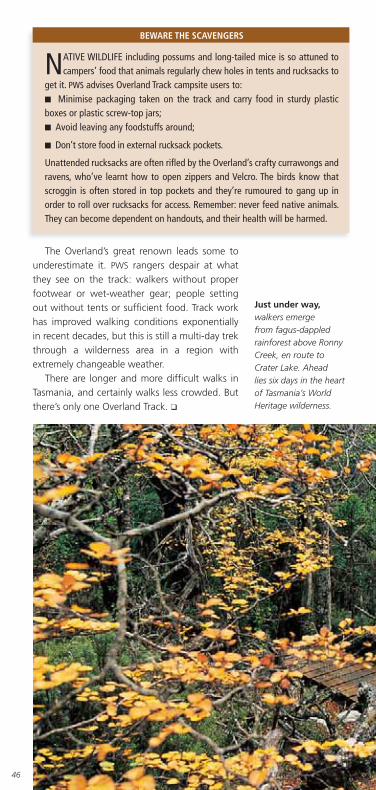
Just under way,walkers emerge from fagus-dappled rainforest above Ronny Creek, en route to Crater Lake. Ahead lies six days in the heart of Tasmania’s World Heritage wilderness.
46

SINGING IN THE RAIN
PROVIDED YOU’RE PROPERLY EQUIPPED (see The waterproofi ng chall-enge, page 10), walking in the rain can be a blessed experience. Sure, the
big view disappears as mist cloaks hillsides and shrouds treetops, buteverything close up becomes vivid. Eucalypt trunks moisten into deepergreens, browns, greys and pinks. Beech and myrtle leaves seem smaller, moredelicate and more exquisitely patterned. Hakeas seem spikier, moss banksmore elaborate, lichen festoons more pendulous. Bird cries are amplifi ed andcreeks run with a calming, muted sound.
■ CRACLAIR TOURS
6-day Overland Track tour.03 6339 4488 or 0419 544 748,www.craclair.com.au
■ TAZ TOURS WILDERNESS
ADVENTURES CRADLE MOUNTAIN
6-day Overland Track Tour.03 6492 1181
■ TIGER TRAILS
8-day Overland Track Tour.03 6234 3931 or 0427 397 815,www.tasmaniawalks.com
■ CRADLE MOUNTAIN HUTS
6-day tour with accommodationin private huts. 03 6391 9339,www.cradlehuts.com.au
■ TASMAN BUSH TOURS
6-day Overland Track Tour.03 6423 2335 or 0419 325 165,www.tasmanbushtours.com
■ TASMANIAN WILDERNESS
EXPERIENCES
6-day Overland Track tours.03 6261 4971,1300 882 293or 0414 238 458,www.bctas.com.au
■ TASMANIAN EXPEDITIONS
8-day Cradle MountainOverland Track Tour.03 6339 3999 or 1300 666 856,www.tas-ex.com
GUIDED OPTIONS
OV
ER
LA
ND
TR
AC
K
47

Afternoon light bathes Pindars Peak, about 13 km east of Deadmans Bay and a prominent landmark along the South Coast Track’s eastern section.

SO
UT
H C
OA
ST
TR
AC
K
▲
TheSouth Coast
WHEN ASKED about their experiences on the SouthCoast Track, most tired walkers tend to wave their
arms and jabber disjointed phrases. They’ll mention theisolation. The beaches. The islands. The forests. The Iron-bounds. The views. The rain. The mud.
It’s not that the 85 km track, which connects Melaleucaand Cockle Creek, defi es description. Modern bushwalkershave been writing about it for decades and Aboriginalpeople used the route for thou sands of years. The track isclearly marked.
SOUTHWEST WILDERNESSISOLATION
49
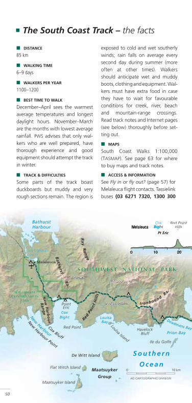
■ The South Coast Track – the facts
50
■ DISTANCE
85 km
■ WALKING TIME
6–9 days
■ WALKERS PER YEAR
1100–1200
■ BEST TIME TO WALK
December–April sees the warmestaverage temperatures and longestdaylight hours. November–Marchare the months with lowest averagerain fall. PWS advises that only wal-kers who are well prepared, havethorough experience and goodequipment should attempt the trackin winter.
■ TRACK & DIFFICULTIES
Some parts of the track boastduckboards but muddy and veryrough sections remain. The region is
exposed to cold and wet southerlywinds; rain falls on average everysecond day during summer (moreoften at other times). Walkersshould anticipate wet and muddyboots, clothing and equipment. Wal-kers must have extra food in casethey have to wait for favourableconditions for creek, river, beachand mountain-range crossings.Read track notes and Internet pages(see below) thoroughly before set-ting out.
■ MAPS
South Coast Walks 1:100,000(TASMAP). See page 63 for whereto buy maps and track notes.
■ ACCESS & INFORMATION
See Fly in or fl y out? (page 57) forMelaleuca fl ight contacts. Tassielinkbuses (03 6271 7320, 1300 300

SO
UT
H C
OA
ST
TR
AC
KS
OU
TH
CO
AS
T T
RA
CK
SO
UT
H C
OA
ST
TR
AC
KS
OU
TH
CO
AS
T T
RA
CK
51
Bay, Granite Beach (east) andSouth Cape Rivulet. All have pittoilets. There are ample campsitesat Cockle Creek. Water is usuallynot a problem. Most creeksmarked on the South Coast Walksmap fl ow throughout summer.Ensure you set out with suffi cientwater to complete the IronboundRange and the South Cape Rangecrossings. This is a fuel-stove-onlyarea. Carry out all rubbish.
■ FEES
Walkers must have a valid NationalParks pass (see page 64 for PWS
contact details). Melaleuca hutsand all wal kers’ campsites are free.
Melaleuca airstrip is the arrivalpoint for eastbound walkers, anddeparture point for the westbound.Flights may be delayed or cancelledbecause of poor weather. Huts atMelaleuca provide shelter forwalkers awaiting aircraft.
520) runs services to/from CockleCreek on Mon, Wed and Fri fromearly December to late March. ThePWS Southwest NP (03 6288 1283)and Huonville (03 6264 8460) offi -ces have information. South CoastTrack on the web:www.parks.tas.gov.au/recre-ation/track notes/scoast.html
■ FACILITIES & WATER
There are basic huts sleeping20 at Melaleuca. Recommendedwalkers’ campsites en route are atPoint Eric, Louisa River, DeadmansBay, New River Lagoon, Surprise
MUD-LOVERS WELCOME
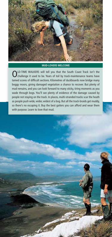
OLD-TIME WALKERS will tell you that the South Coast Track isn’t the challenge it used to be. Years of toil by track-maintenance teams have
tamed scores of diffi cult sections. Kilometres of duckboards now bridge many boggy moors, giving damaged vegetation a chance to recover. But plenty of mud remains, and you can look forward to many sticky, tiring moments as you wade through bogs. You’ll see plenty of evidence of the damage caused by people not staying on the track. In places, multi-stranded tracks scar the heath as people push wide, wider, widest of a bog. But all the track-braids get muddy, so there’s no escaping it. Buy the best gaiters you can afford and wear them with purpose. Learn to love that mud.
SO
UT
H C
OA
ST
TR
AC
K
53
BUT WHEN A SOU’-WESTERLY front rolls in on the Roaring Forties, the rain comes in tor-
rents, washing away lucid thought. Trees bend and snap, and streams rise, stranding walkers short of campsites and leaving them feeling utterly beyond help. This is a coast where one’s place in the universe is never in doubt. Money, position, education and status don’t count and won’t help. Dry boots are objects to worship. A cup of hot soup is better than any gourmet’s indul gence.
When the plane departs Melaleuca (see Fly in or fl y out? page 57) and leaves your party behind, a pervading quiet descends on the bush. You can delay for a time at the Melaleuca bird hide, where you may see the endangered orange-bellied parrot. But eventually you shoulder your rucksack – and it’s heavy, packed with at least seven days’ food – and head for the coast at Cox Bight.
There are periods of relatively gentle going along boardwalks or beaches (although these can
Dedicated mud man, guide Ben Christie-Johnston (opposite) observes the Minimum Impact Bushwalking code – which means sticking to the track even when it sticks to you.
Day-one walkers (below) peer east from the New Harbour Range, over Cox Bight to the terrain ahead. The most distant range, the 1000 m high Iron bound Range, is the South Coast Track’s hardest ascent.

be rendered more diffi cult by wind, rain or fatigue) between a procession of obstacles, minor and major. If heavy rain has fallen, any of several small creeks along the way can present problems, and several others – including Faraway Creek, Louisa Creek, Louisa River and South Cape Rivulet – can be simply impassable. There are several ranges of varying size to cross. The Ironbound Range is the most diffi cult (see Over the Iron-bounds, opposite), but the South Cape Range, Red Point Hills and numerous lesser climbs all require work. There will also be wet and boggy sections to negotiate every day (see Mud-loverswelcome, page 52).
Stunning seashore creatures (above) on beach sections provide welcome relief from the track’s frequent challenges, such as the cold and tricky crossing of the Louisa River (below).

OVER THE IRONBOUNDS
FROM THE MOMENT you start on the South Coast Track the Ironbound Range beckons.
It’s visible days before you reach it and days after you cross it. It’s the big barrier, the big presence, the big challenge that divides the track into western and eastern halves.
When you tackle the Ironbounds you’ll start the day close to sea level, climb to more than 900 m and descend to almost sea level. The crossing must be completed in a day. There are no campsites en route and the weather can change in the time it takes to unpack a raincoat. The western side of the range is mostly exposed moorland. There’s alpine vegetation across the top – pandani, scoparia, pineapple grass and various stunted eucalypts. Magnifi cent temperate rainforest of myrtle, sassafras and leatherwood dominates the sheltered eastern side.
Tales of crossings are harrowing and hilarious. People reach Dead mans Bay camp exhausted and practically hypothermic after enduring snow and sleet over the top and steady drizzle on the endless, draining, slippery, root-strewn rainforest descent. Then they wash off the mud and grime and discover they’re sunburnt! The fi rst few hours of the exposed climb from Louisa River were done under clear skies, and they forgot to put on sunscreen. How funny. How painful. How satisfying to have made it.
Melaleuca fl owers colour South Coast peat moorlands in spring. The beautiful blossoms feature along the track between the Ironbound Range and the settlement at Melaleuca.
The Ironbound Range crossing is the track’s most demanding section. It must be done in a day – there are no campsites – and the track on the eastern side (above) is muddy, root-strewn and energy-sapping.
SO
UT
H C
OA
ST
TR
AC
K
55
The South Coast Track is an emotional challenge – a mind game. It requires much more preparation and planning than shorter walks. The weather will be bad. Your boots and feet will get wet. Crossing the Ironbounds will be diffi cult. The reward – which will linger in memory long after you’re home – is an after-image of an isolated, weather-battered coastline backed by moun-tain ranges; of cold waves crashing on a wilderness beach, cloud halos hanging over dramatic peaks and a thin quartzite track snaking over hills. If you’re ready to meet its demands, the South Coast Track is an essential destination. ❑
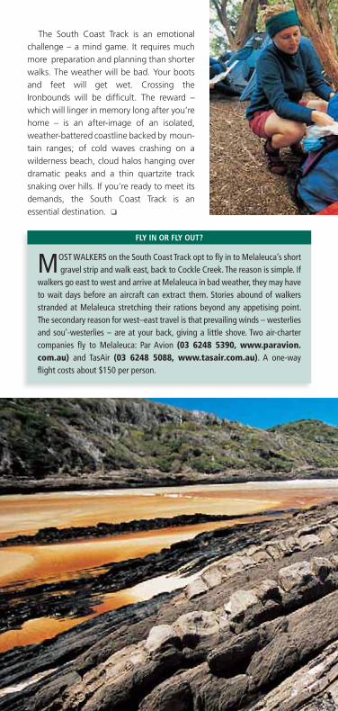
FLY IN OR FLY OUT?
MOST WALKERS on the South Coast Track opt to fl y in to Melaleuca’s short gravel strip and walk east, back to Cockle Creek. The reason is simple. If
walkers go east to west and arrive at Melaleuca in bad weather, they may have to wait days before an aircraft can extract them. Stories abound of walkers stranded at Melaleuca stretching their rations beyond any appetising point. The secondary reason for west–east travel is that prevailing winds – westerlies and sou’-westerlies – are at your back, giving a little shove. Two air-charter companies fl y to Melaleuca: Par Avion (03 6248 5390, www.paravion.com.au) and TasAir (03 6248 5088, www.tasair.com.au). A one-way fl ight costs about $150 per person.

SO
UT
H C
OA
ST
TR
AC
K
57
Halfway home. Walkers at LittleDeadmans Bay campsite (above)pack rucksacks and prepare topush on after recovering fromthe Ironbound Range crossing.
Tannin-stained waters ofSurprise Rivulet (below) spillacross the beach at Surprise Bay.From here, only one major challengeremains for eastbound walkers:the South Cape Range.
■ CRACLAIR TOURS
9-day South Coast Track Tour;16-day Port Davey Track andSouth Coast Track Tour.03 6339 4488 or0419 544 748,www.craclair.com.au
■ TASMANIAN EXPEDITIONS
9-day South Coast Track Tour;16-day Port Davey Track andSouth Coast Track Tour.03 6339 3999 or1300 666 856www.tas-ex.com
■ TAS WILDERNESS EXPERIENCES
8-day South Coast Track Tour.03 6261 4971,1300 882 293 or0414 238 458,www.bctas.com.au
■ TIGER TRAILS
10-day South Coast Track Tour.03 6234 3931 or0427 397 815www.tasmaniawalks.com
GUIDED OPTIONS

58
Tassie’s othergreat walksTASMANIA IS BLESSED with a tremendous variety of walking options:
day-long meanders, multi-day treks and, for the experienced walker, aseemingly limitless supply of trackless wilderness.
Day walks are ideal warm-ups for longer journeys. The booklet Tasmania’sGreat Short Walks covers 60 walks, ranging from 20-minute strolls tostrenuous undertakings of several hours. It’s available from most visitorinformation centres or the PWS will post it out – phone 1300 135 513 toorder. There’s also a version online at www.parks.tas.gov.au/recreation/shortwalks/index.html.
In general, the multi-day tracks excluded from this guidebook are morediffi cult than those that have been described. A notable exception is therelatively new Leeaberra Track, in Douglas-Apsley NP, which is rated by thePWS as moderately difficult. The Leeaberra runs for 28 km from ThompsonsMarshes in the park’s north to the Apsley River waterhole. It passes throughDouglas-Apsley’s beautiful dry eucalypt forests and rainforest. On or near theroute are spectacular waterfalls, natural swimming holes and stunning viewsof the Douglas River valley and Tasmania’s east coast. Most walkers take 2–3days to complete the track, depending on the time they devote to side-tripsand relaxation. Contact the Freycinet NP offi ce (03 6256 7000,[email protected]), go to www.parks.tas.gov.au/natparks/douglas-apsley/index.html or see TASMAP’s Douglas-Apsley National ParkMap and Notes (1:50,000) for more information.
Better known, but little used, the Port Davey Track is walked by about 200people each year. This 70 km track, which links Scotts Peak Road and Melaleuca
THE TASMANIAN TRAIL
THE 477 KM TASMANIAN TRAIL, which extends from Devonport on the northcoast to Dover, south of Hobart, is cast as a route for horseriding, mountain
biking and walking. The Australian Trail Horse Riders Association played thebiggest role in its establishment, and so the route (often following roads or fi retrails) and distances between camps (daily average about 32 km) mean that it’sbetter suited to horseriders and mountain bikers than walkers. Some parts of thetrack make for very pleasant walking – the section across the Gog Range, westof Deloraine, is often cited. But the track misses major national parks andwilderness areas (where horses aren’t allowed), and most walkers seem contentto exhaust Tasmania’s extensive network of wilderness tracks rather than take tothe Tasmanian Trail. The net result is positive: horseriders and mountain bikershave their own long, varied trail with little need to dodge slow-moving, pack-laden walkers.
59
and lies within Southwest NP, takes 4–5 days. The route dissects the Western Arthur and White Monolith ranges and crosses buttongrass plains and several watercourses. There are no strenuous climbs, but isolation, unpredictable weather and classic south-west mud make this a serious undertaking. Contact Mt Field NP (03 6288 1149) or Huonville (03 6264 8460) PWS offi ce for more information. South Coast Walks (1:100,000) has track notes.
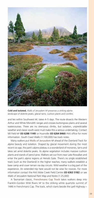
Many walkers put Walls of Jerusalem NP ahead of the Overland Track for alpine beauty and isolation. Shaped by glacial movement during the most recent ice age, the park’s alpine plateau is a wonderland of moraines, tarns and lakes set amid dolerite peaks. Its alpine vegetation includes massive cushion plants and stands of pencil pine. Walkers set out from near Lake Rowallan and enter the park’s alpine regions at Herods Gate. There’s no single established track (such as the Overland) in the higher reaches; many walkers establish a base camp and cover terrain via day circuits. Wild weather is a big part of the experience. An extended trip here would not be wise for novices. For more information contact the PWS Mole Creek Field Centre (03 6363 5182) or see Walls of Jerusalem National Park Map and Notes (1:25,000)
A Tasmanian classic, Frenchmans Cap Track takes walkers deep into Franklin-Gordon Wild Rivers NP to the striking white quartzite summit of 1446 m Frenchmans Cap. The track, which starts beside the Lyell Highway
Cold and isolated, Walls of Jerusalem NP preserves a striking alpine landscape of dolerite peaks, glacial tarns, cushion plants and conifers.

60
about 55 km east of Queenstown, is 23 km long and considerably more challenging than other Tasmanian tracks. It’s recommended that walkers get experience on the Overland and other tracks before attempting Frenchmans. The track surface is rough and muddy for long sections, especially across the poorly drained Loddon Plains – known as “the Sodden Loddons”. Most of the 700 or so walkers who tackle Frenchmans each year take 3–5 days to complete the 46 km return journey. For more information contact the PWS
Queenstown offi ce (03 6471 2511) or see Frenchmans Cap Walk Map & Notes (1:50,000). Frenchmans Cap Track on the web: www.parks.tas.gov.au/recreation/tracknotes/frmans.html.
Federation Peak is one of Tasmania’s most spectacular and isolated mountains and a longed-for objective of many experienced walkers. It’s only 1224 m high but of striking appearance – a steep-sided bluff rising above serrated ridges in the heart of the Southwest Wilderness. Most parties set out from Scotts Peak Dam (4–5 days walk to the peak) or Farmhouse Creek (2–3
Donaghys Hill Lookout affords peerless views of the Franklin River valley and, in the distance, the distinctive Frenchmans Cap dome.

days). The walk is strenuous, with deep mud and cliffs to negotiate. Unfavourable conditions prevent about 50 per cent of parties from attempting the summit; most plan for 10–12 days in the bush to allow time to wait for better weather. The fi nal climb is extremely diffi cult; some say dangerous.
Many experienced walkers rate the Western Arthur Range as Tasmania’s greatest walking challenge. North-west of Federation Peak in the Southwest Wilderness, the range is only 15 km long but breathtakingly spectacular. It’s a compact chain of more than 20 major peaks, forbidding cliffs and countless lakes and glacial tarns. The established walking route follows the range’s jagged ridgeline from peak to peak. The track is rough and very exposed. It rises and falls through precipitous terrain and is often more reminiscent of a rock-climb than a trek. A full traverse of the range generally takes 10 days. Daily distances are short and exhausting, with the regularly wild weather a major factor – walkers are advised to expect only one clear day in four.
Walkers contemplating Federation Peak or the Western Arthurs should contact either the Mt Field NP (03 6288 1149) or Huonville (03 6264 8460) PWS
offi ces as a starting point for more information. John Chapman’s guidebook South West Tasmania is highly regarded.
61

62
Informationand contactsFollowing are Tasmania’s fully accredited walking guides, a summary of the routes they offer and contact details. Note that routes and trip duration may change from season to season.
■ BAY OF FIRES WALKFour-day coastal walk in Mount William NP (accommodation in fi xed camp and private lodge), including transport ex Launceston and all food. Phone 03 6391 9339, www.bayoffi res.com.au
■ CRACLAIR TOURSWalks and tours in World Heritage Area national parks (accommodation in tents or huts), including transport ex Launceston, all food and some equipment. The Overland Track (6 days); Around Cradle Mountain (4); Heart of World Heritage (5); Pine Valley (5); Frenchmans Cap (5); Walls of Jerusalem (4); Walls of Jerusalem & Cradle Mountain (6); Port Davey Track Tour (7); South Coast Track Tour (9); Port Davey Track and South Coast Track Tour (16). Phone 03 6339 4488 or 0419 544 748, www.craclair.com.au
■ CRADLE MOUNTAIN HUTSSix-day walk from Cradle Mountain to Lake St Clair along the Overland Track (accommodation in private huts with showers), including transport ex Launceston and all food. Phone 03 6391 9339, www.cradlehuts.com.au
■ FREYCINET ADVENTURESWalking and walking/kayaking tours in Freycinet NP (accommodation in fi xed camp and tents), including all food and some equipment. Hazards Escape walk (2 days); Freycinet Adventure kayak/walk (3); Freycinet Expedition kayak/walk (5). Phone 03 6257 0500, www.freycinetadventures.com
■ FREYCINET EXPERIENCE WALKPackage of four day-walks in Freycinet NP (accommodation in Friendly Beaches Lodge). Phone 03 6223 7565 or 1800 506 003, www.freycinet.com.au
■ TASMAN BUSH TOURSWalks and tours in national parks throughout Tasmania (accommodation in tents and cabins) including transport, food and some equipment. Around Cradle Mountain Tour (3 days); Frenchmans Cap Tour (6); Overland Track Tour (6); Port Davey Tour (7); South Coast Track Tour (7); South West Expedition Tour (16); Walls of Jerusalem Tour (3); Cradle Cabin Tour (2). 036423 2335, 0419 325 165. www.tasmanbushtours.com
63
■ TASMANIAN EXPEDITIONSWalks and tours in national parks throughout Tasmania (accommodation usually in tents) including transport ex Launceston or Hobart, all food and some equipment. Cradle and Walls of Jerusalem Tour (6 days); Cradle Mountain Overland Track Tour (8); Cradle Walk Tour (3); Freycinet Walking Tour (3); South Coast Track Tour (9); Cradle and the West Walks Tour (6); Walls of Jerusalem Circuit Tour (6); Frenchmans Cap Trek Tour (5); Tasmanian Panorama Tour (13); Port Davey Track and South Coast Track Tour (16); Blue Tiers to Bay of Fires Tour (6). Phone 03 6339 3999 or 1300 666 856;www.tas-ex.com
■ TASMANIAN WILDERNESS EXPERIENCESWalks in national parks throughout Tasmania (accommodation usually in tents), including transfers to/from airports, transport to/from walks and before/after walk accommodation at Base Camp Tasmania. Mt Anne Circuit Tour (4 days); Freycinet Circuit Tour (3); South Coast Track Tour (8); Douglas Apsley Circuit Tour (5); Frenchmans Cap Tour (5); Federation Peak Tour (8); Lake Oberon (Western Arthurs) Tour (5); Mt Field Circuit Tour (3); Port Davey Track Tour (6); South West Cape Tour (8); Western Arthurs Traverse Tour (9); Walls of Jerusalem Tour (4); Tasman Peninsula Tour (3); Tasman Trail Tour (4); Overland Track Tour (6). Phone 03 6261 4971, 1300 882 293, or 0414 238 458; www.bctas.com.au
■ TAZ TOURS WILDERNESS ADVENTURES CRADLE MOUNTAIN
Overland Track Tour (6 days). Phone 03 6492 1181.
■ THE MARIA ISLAND WALKFour-day walk from McRaes Isthmus to Darlington (accommodation at fi xed camps and historic house), including transport to/from Hobart, all food and some equipment. Phone 03 6227 8800; www.mariaislandwalk.com.au
■ TIGER TRAILS ECO ADVENTURESWalks in national parks and wilderness areas throughout Tasmania (accommodation usually in tents) including transport ex Launceston, Burnie or Hobart, all food and some equipment. Maria Island Dreaming Walk (4 days); Freycinet Circuit Tour (3); Walls of Jerusalem Tour (4); Overland Track Tour (8); Best of Cradle and Walls Tour (7); Tarkine Forest of the Giants (6); Wild Tarkine Coast (6); Tarkine Rainforest Track (4); South Coast Track Tour (10). Phone 03 6234 3931 or 0427 397 815; www.tasmaniawalks.com
■ WILDERNESS ADVENTURESVarious walks in the southwest, specialising in photography trips.Phone 03 6229 2559, www.richardbennett.com.au
Maps & track notesLists of TASMAP agents (mainland and Tasmania), Service Tasmania outlets (where maps are usually sold) and sales catalogues are available online: www.dpiwe.tas.gov.au > Property, Titles and Maps >TASMAP

64
For more information about sales outlets, or to place an order, contact TASMAP (ph. 03 6233 7741, fax 03 6233 6071,email: [email protected])
Or write to:TASMAP – Sales ordersDepartment of Primary Industries, Water and EnvironmentGPO Box 44Hobart Tas. 7001
Track notes for the Overland Track, Tasman Coastal Trail, Freycinet Peninsula Circuit and South Coast Track are available online: www.parks.tas.gov.au/recreation/tracknotes/index.html
The Overland Track – A Walker’s Notebook ($10) is available from Parks Publications (ph. 03 6233 6285 Mon.– Fri., 9 a.m.– 5 p.m. or email: [email protected])
Parks & Wildlife Service Tasmania (PWS)General bushwalking questions should be directed to PWS
Enquiries (ph. 1300 135 513, Mon.– Fri. 9 a.m.– 5 p.m., or online at www.parks.tas.gov.au/enquiries.html).
From December to Easter the PWS bushwalking information offi cer is available (ph. 1300 135 513, Mon.– Fri. 9 a.m.– 5 p.m.).
Or write to:Parks and Wildlife Service GPO Box 1751Hobart, Tas. 7001
Tasmania visitor informationThe Tourism Tasmania website (www.discovertasmania.com.au) is the best starting point for information about everything there is to see and do in Tasmania. You can make specifi c information requests through the web page www.discovertasmania.com/home/index.cfm?display=inforequest
Tasmanian Travel Centres in Melbourne (259 Collins St, between Elizabeth and Swanston streets) and Sydney (60 Carrington St, cnr Wynyard St, near George St) have abundant information; you can phone (1800 806 846, free call from anywhere in Australia) or email ([email protected]) to request information from them.
There are Tasmanian Travel and Information Centres in Hobart (cnr Davey St and Elizabeth St, 03 6230 8233), Launceston (12–16 St John St, 03 6336 3133), Devonport (92 Formby Rd, 03 6424 4466) and Burnie (Civic Centre, Precinct, Little Alexander St, 03 6434 6111).