COASTAL ZONE VULNERABILITY AND ADAPTATION TO CLIMATE ...
23
COASTAL ZONE VULNERABILITY AND ADAPTATION TO CLIMATE CHANGE IN LIBERIA BY: ASST. PROF. DAVID L. WILES, SR. NATIONAL CONSULTANT ON CLIMATE CHANGE CLIMATE CHANGE UNIT ENVIRONMENTAL PROTECTION AGENCY OF LIBERIA MONROVIA, LIBERIA PRESENTED AT: TRAINING WORKSHOP ON ADAPTATION AND VULNERATION TO CLIMATE CHANGE MAPUTO, MOZAMBIQUE APRIL 18-22, 2005
Transcript of COASTAL ZONE VULNERABILITY AND ADAPTATION TO CLIMATE ...
COASTAL ZONE VULNERABILITY AND ADAPTATION TO CLIMATE CHANGE
IN LIBERIA
BY:
ASST. PROF. DAVID L. WILES, SR. NATIONAL CONSULTANT ON CLIMATE CHANGE
CLIMATE CHANGE UNIT ENVIRONMENTAL PROTECTION AGENCY OF LIBERIA
MONROVIA, LIBERIA
PRESENTED AT: TRAINING WORKSHOP ON ADAPTATION AND VULNERATION
TO CLIMATE CHANGE MAPUTO, MOZAMBIQUE
APRIL 18-22, 2005

I. National Circumstances 1. Location The absolute location of Liberia is latitudes 4o20’ and 8o30’ north of the equator and longitudes 7o18’ and 11o20’ west of the prime meridian. Liberia covers an area of 111,370 sq. km. 15,050 sq. km is water and the remaining 96,320 sq. km is land. Relatively, it is boarded to the south by the North Atlantic Ocean for about 560 km. La Cote d’Ivoire is to the east with a border length of 598 km. Sierra Leone is to the West with a border of 370 km. La Cote d’Ivoire is to the East with a border 598 km long. Sierra Leone is to the west with a border of 370 km. In the north is Guinea with a border of 540 km long. Monrovia, the capital is the country’s largest city.
B. Geographical Features In territorial terms Liberia is the fifth smallest country on the Continent of Africa. The extreme southeast of the county is closer to the equator than any other coastal part of West Africa and some 1,600 km to Brazil. It is closer to the South American Continent than any other African State. The relief systems of Liberia is sub-divided into four relief belts parallel to the coast rising in steps, one behind the other they are: the Coastal Belt, Rolling Hills belt, the Dissected Plateau belt and the Northern Highlands belt. The Coastal Belt is about 50ft (15 meters) above sea level, while the Rolling Hills is 300 ft (100 meters) above sea level. The Dissected plateau and the Northern Highland are 1,000 feet (300 meters) and 6,000 feet (1,800 meters) above sea-level respectively. There are four major soil types. All have low moisture retention capacity. They are latosols or lateritic soils which constitute 75 percent of the soil cover of the country. Because of its lack of nutrients and compact texture and impermeability, latosols are of low to median fertility. Lithosols make up about 17 percent of Liberia’s soil cover. It has high gravel content because it occurs along the coast. It contains most of the mangrove swamps and trees. Drainage is poor where clay is in high concentration. Regosols are subjected to long period water-logging. Alluvial soils constitute only 3 percent of the soil cover. It contains high amount of necessary plant nutrients and very fertile. It occurs on flood plains. Vegetation Liberia is within the Tropical Rain Forest Vegetation Belt of West Africa. Most of the country comprises of forest except a narrow strip along the coast where mangrove vegetation alternate with coastal savanna. The climate conditions in the entire country allow the vegetation to develop into a tropical rainforest. Based on the nature of the climate and soil types, three vegetation belts can be identified in Liberia. They are the Coastal Savanna, the High Rainforest Belt, and the Northern Savanna. The Coastal Savanna consists of low grasses with scattered low trees. It also contains palm and coconut trees along with mangrove trees and raphia palms. The High Rainforest Belt can be divided into an evergreen rainforest zone and the moist semi-deciduous forest zone. The evergreen rain forest receives 4475 mm of rainfall annually and consists of plant species which do not have a well-developed marked period of leaf-

3
sharing. The tallest trees in this zone reach about 50 meters. The semi-deciduous forest is a transition to the deciduous forest type found in La Cote d’Ivoire. The long dry season (5 to 6 months) forces many plant species to drop their leaves during course of this period to minimize their evaporation of moisture.
The Northern Savanna comprises the tall grass woodlands in the far north-western parts of the country and a small portion in the north east (Nimba County). It is man-made vegetation due to continuous burning and clearing for agricultural purposes. This prevents the original vegetation from regenerating.
Drainage The country is well-watered by six major rivers and numerous small ones. These rivers and their many tributaries have developed into a dense drainage system with a dendrite pattern. This drainage system has been determined by the geological structure and by the general slope of the relief of the country. Rivers in Liberia glow from northwest to southeast except the Cavalla River and its tributary, the Dougbe River which flow northeast to south. Majority of Liberian Rivers originate in Guinea. The six major rivers in Liberia are Cavalla, Cestos, St. John, St. Paul, Lofa and Mano Rivers. Climate The equatorial position and the distribution of high and low pressure belts over the African Continent and the Atlantic Ocean determine the climate of Liberia and move generally of West Africa. Because of this position and the moderating influence of the nearby Atlantic Ocean, there is a fairly warm temperature throughout the year with a very high humidity. Seasons in Liberia are not determined by changing temperature because it is fairly warm throughout the year, but by the prevailing precipitation (rainfall). Therefore, a rainy (wet) and dry (sunny) seasons can be differentiated. The Liberian coastline runs approximately from southeast to northwest and at right angles to the prevailing southwesterly rain bearing winds... As the maritime air reaches the coast, it is forced to rise, it cools and condensation takes place which causes the extremely heavy rainfall. The average annual rainfall near the coast amounts to 4770 mm. Towards the interior, the amount of rainfall decreases to an average annual of 2080 mm. The rainy season begins in April and ends in October, while the dry season is from November to March. Because of the equatorial position of Liberia, the sun is almost directly overhead at noon throughout the year, and insulation is very intense in all parts of the country. Therefore, high temperatures with very little monthly variations should be expected. Along the coast the proximity of the Atlantic Ocean has a very moderating effect on temperature; annual and daily variations are evenly balanced, while towards the interior, the continental influence becomes more dominant, the range of temperature widens. It is difficult to quote figures for temperature, since they vary considerably with location and altitude; but 27oC to 32oC and 23oC to 28oC at night seems to be fairly representative. The influence of the equatorial maritime air masses causes the very high humidity in Liberia. Relative humidity ranges from 90 percent to 100 percent during the rainy season;
4
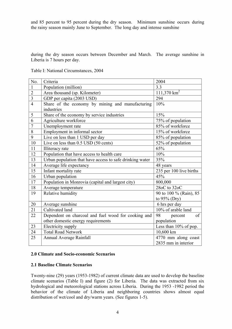
and 85 percent to 95 percent during the dry season. Minimum sunshine occurs during the rainy season mainly June to September. The long day and intense sunshine during the dry season occurs between December and March. The average sunshine in Liberia is 7 hours per day. Table I: National Circumstances, 2004 No. Criteria 2004 1 Population (million) 3.3 2 Area thousand (sp. Kilometer) 111,370 km2 3 GDP per capita (2003 USD) 294 4 Share of the economy by mining and manufacturing
industries 10%
5 Share of the economy by service industries 15% 6 Agriculture workforce 75% of population 7 Unemployment rate 85% of workforce 8 Employment in informal sector 15% of workforce 9 Live on less than 1 USD per day 85% of population 10 Live on less than 0.5 USD (50 cents) 52% of population 11 Illiteracy rate 65% 12 Population that have access to health care 10% 13 Urban population that have access to safe drinking water 35% 14 Average life expectancy 48 years 15 Infant mortality rate 235 per 100 live births 16 Urban population 45% 17 Population in Monrovia (capital and largest city) 800,000 18 Average temperature 28oC to 32oC 19 Relative humidity 90 to 100 % (Rain), 85
to 95% (Dry) 20 Average sunshine 6 hrs per day 21 Cultivated land 10% of arable land 22 Dependent on charcoal and fuel wood for cooking and
other domestic energy requirements 98 percent of population
23 Electricity supply Less than 10% of pop. 24 Total Road Network 10,600 km 25 Annual Average Rainfall 4770 mm along coast
2835 mm in interior 2.0 Climate and Socio-economic Scenarios 2.1 Baseline Climate Scenarios
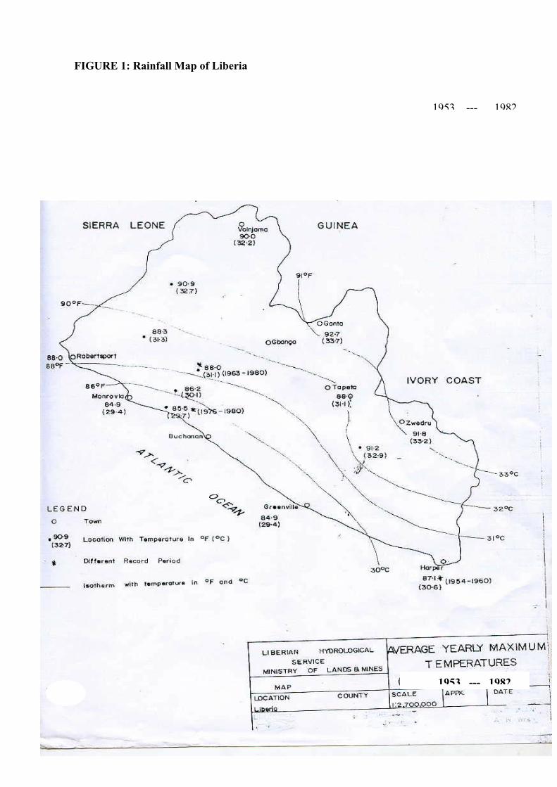
Twenty-nine (29) years (1953-1982) of current climate data are used to develop the baseline climate scenarios (Table I) and figure (2) for Liberia. The data was extracted from six hydrological and meteorological stations across Liberia. During the 1953 -1982 period the behavior of the climate of Liberia and neighboring countries shows almost equal distribution of wet/cool and dry/warm years. (See figures 1-5).

5
Table I: Baseline Climate Scenarios of Liberia (1953 – 1982)
Year Jan. Feb. Mar. Apr. May June July. Aug. Sept. Oct. Nov. Dec. Mean Temperature (0C) 1953- 1982
290 290 300 300 290 320 300 310 290 280 280 310
Mean Rainfall (mm) 1953- 1982
1785 2047 2090 2355 4693 3945 3105 3740 3135 2844 2374 2103
Monthly sunshine (hr.) 1953- 1982
9.0 9.0 8.5 7.5 7.3 7.4 7.2 7 6.8 7 7.5 8.5
Mean Humidity (%) 1953-1982
95 95 95 97 98 98 99 96 97 98 96 95
Source: Climatology Unit, Department of Geography, University of Liberia (1984) As shown on Table I, the months of April to September received significant among of rainfall as compared with the months of October to March. This trend coincides with the variation in the rainy and dry seasons. Table I also shows that high mean temperature correlates with the rainy seasons from April to October.

6
Rainfall data and annual isotopes in rain
COTE D’ IVOIRE
7
FIGURE 1: Rainfall Map of Liberia
1953 --- 1982
1953 --- 1982
8
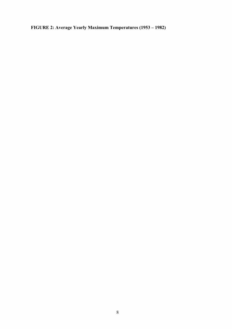
FIGURE 2: Average Yearly Maximum Temperatures (1953 – 1982)

9
FIG. 3: Ave. Minimum Temperatures1953-1982
1953 - 1982

10
--
FIGURE 4: maximum Monthly Temperature (1953 -- 1982)
1953 - 1982

11
Figure 5: Minimum Monthly Temperature (1953 -- 1983)
1953 -- 1982

12
.4.0 Coastal Zone and Resources A. Background on Coastal Zone Liberia lies between latitude 4o20’ and 8o30’ north and longitude 7o18’ and 11o20’ west. Liberia has a coastline of 565 km (350 miles) long. Tremendous benefits could be derived from coastal and marine resources. Liberia also claims on economic zone of 13 nautical miles and a territorial zone of two hundred (200) nautical miles. Many coastal and marine environments in Liberia have been suffering rapid deterioration due to a combination of increase population pressure and uncontrolled economic activities. Such unbalanced developments, with negative economic and ecological consequences in the country required to be reversed and pursue to achieve sustainable use of coastal and marine resources. Liberia has a surface area of 38,120 sq. miles (96,320 km2). The area of the continental shelf is 18,400 km2 the width of the continental shelf range between 16 km to 56 km. The area of Liberia’s Exclusive Economic Zone (EEZ) is 229,700 km2. The Liberian population is approximated at 3.3 million people. Liberia’s population growth rate is estimated to be 3.5 percent. The major coastal cities in Liberia are Monrovia, Robertsport, Buchanan, Greenville and Harper. The major sea ports are Monrovia and Buchanan, while the major lagoons are Bernard Beach Lagoon, the Sherman Lagoon and Caesar Beach Lagoon. The major lakes are Lake Piso in the northwest and Lake Shepherd in the southeast. Areas occupied by mangrove forests are not known neither the actual rate of erosion is known. No data exists for tidal range and ocean currents. The coastal marine ecosystems are subjected to all kinds of misuse such as beach erosion due to sand mining, oil pollution, solid and sewage wastes dumps, human settlement and the discharge of run-off agricultural activities, etc. Liberia is not oil producing country but the use of its oil refinery facilities for storing and distribution in the local markets mean inevitable exposure to the threat of oil pollution. Some countries in the Gulf of Guinea such as Gabon, Cameroon, Cote d’Ivoire and Nigeria are net exporters of oil. The patterns of onshore–offshore winds and ocean currents means that any oil spill from any of the off-shore or on-shore based petroleum activities can be transformed easily into regional oil pollution problem. Most of the countries along the Gulf of Guinea have major refineries on the coast. Only a few of them have proper affluent treatment plants or facilities, thereby adding to the threat of pollution from oil along the coastal zone. Liberia is one of the most endowed areas of the West Coast of Africa in terms of river systems. There are sixteen (16) rivers in Liberia. Six (6) are considered major rivers in Liberia. They include the Mano River, Lofa River, St. John River, St. Paul River, Cestos River and the Cavalla River. These rivers enter the coastal zone from an extensive network of catchments basins transporting great quantity of sediments from land based industrial and agricultural activities, thereby contributing significantly to the country’s pollution problems in the coastal and marine ecosystems. Land run-off is an important source of nutrients suspended matters to the coastal and marine environment. Excessive nutrient loading causes eutrofication and harmful algal blooms (HAB). The rivers in Liberia also transport industrial, agricultural, mining and other wastes to the coastal zone.

13
Alteration to natural river flow systems due to harbor construction activities have altered long shore current transport of sediments and in many cases have led to major beach erosion and siltation problems in Liberia. The coastline has an average altitude of 20 ft. above sea level. Actions to control beach erosion around sea ports in Liberia are critically important to maintaining their viability as sites for potential tourism, recreation and commercial activities. B. The Coastal Environment The coastal zone serves many functions and activities. Some of which are as follows:
a) beach sand mining b) transportation c) recreation d) solid and liquid wastes disposals e) supply of fuelwood, charcoal and construction materials f) supply of food (fishing, etc.) g) farming The over all marine and coastal data base is quite limited. Information on climate condition and the patterns of climate change are inadequate. The coastal habitat of Liberia is rich in resources but is readily being altered by human activities. The activities that cause problems in the coastal zone include: 1. High levels of sedimentation in estuaries, lakes and lagoons resulting from poor
upland agricultural practices 2. Loss of mangrove forest and tidal marshlands which support traditional fisheries 3. Over-fishing and use of destructive fishing methods 4. Agricultural run-off and potential pesticide pollution in lagoons, estuaries, lakes and
wetlands 5. Improve utilization of the mangrove forest and determining how much it affects
fishery production 6. The effects of anthropogenic effluents to the coastal and marine zones and their
environmental consequences 7. The implications of all these problems for the socio-economic livelihood status of
the already poor Liberian people. The coastal ecosystem consists of swamp related vegetation which includes mangrove forest and savanna related vegetations. Also common in the coastal zone are palm trees, raphia, mango and other fruit trees and ornamental plants. Temperature along the coast range between 24oC and 29oC. Rainfalls in the coastal zone are higher than the interior of the country. It averages 4567 mm along the coast and gradually decreases to about the average of 28970 mm as one appreciates the northern highland in the interior of the country. This clearly indicates that the coastal and marine environments influence the climate conditions in Liberia. Floodings are very common in the coastal zone. It is projected that about 95 km2 of land in the coastal zone of Liberia will be inundated as a result of one meter sea level rise. About 50% (48 km2) of the total land loss due to

14
inundation will be the sheltered coast. It is evident that with a one-meter sea level rise , parts of the capital city of Monrovia and its environs, West Point New Kru Town, River Cess, Buchanan and Robertsport will be lost due to the fact that the greater parts of these areas are below one meter. The mangrove systems along the coast will be lost. About 250 million United States Dollars worth of land and infrastructures such as Hotel Africa will also be lost. Inundation will be followed by shoreline retreat which would vary along the coast from 10 meters in the higher cliffed zone between Mamba Point and Sinkor to about 20 meters in the lowlands on the Bushrod Island. All the damages that occur along the coast are located on Bushrod Island, Buchanan, Cestos City, and Robertsport. These are the areas on the coast where erosion is most severe. The development of sea ports and sand pits along the coast has meant that the major coastal cities such as Monrovia, Buchanan and Harper are sand starved. Sand is trapped by the sand spit and does not flow west of the constructed ports. This means that massive loss of sand west of these constructions due to erosion is not replaced. The sand eroded from the coast finds its way to the sea ports such as the Freeport of Monrovia and the port of Buchanan, thus causing navigational problems. 4.1 Response Strategies In the coastal zone of Liberia, the suggested response to sea level rise and particularly to coastal erosion is to protect important areas in Monrovia and its environs, Rivercess, Buchanan and Greenville. The following shoreline hardening and stabilization techniques could be used to protect these areas.
(i) The construction of Groyne System Groynes are major techniques of beach stabilization in Africa, where by trunks of rheum palm trees are jetted into the beach and tied together with timber. They are also constructed from reinforced concrete, as on the Maputo Shoreline in Mozambique. They are easy to build, fairly cost effective and locally hold the beach or capture more sand in long shore sediments transport (LST) system. They do not “create new sand but merely re-distribute the sand along the beach. Groyness have been found to be very effective in stabilizing eroded beaches particularly in the Republic of Togo, West Africa. (ii) The construction of Breakwater System Another shoreline stabilization technique that could be useful in the protection of the sandy beaches of Liberia is the Breakwater system. Breakwater systems have the ability to reduce the strength of breaking waves coming onshore, reduce their impact on the shorelines and thus reduce the quantity of sand eroded. (iii) Construction of Revetment System
Revetments are also useful in reducing erosion but need proper construction to be effective. They are expensive and in most cases the beach is lost. Revetments consist of a layer of large boulders on the seaward side and a layer of filter screening material separates these two layers. The void structure of the outer layer on the seaward side is used to dissipate

15
wave energy. The filter screening material of the landward layer allows water to pass through. (iv) Construction of Seawalls or Bulkhead It may be sufficient to build only a low cost seawall or a bulkhead. The seawall has a 1:2 slope a 2-meter beam and a height above water of 1.2 times sea level rise scenario. Particularly for Liberia, it may be necessary to employ an innovative sand management approach to solve the large erosion problem. This could be achieved by trying the end of the sand pit of the Hotel Africa Complex to the mainland so that it becomes a sand-feed to the areas in the Bushrod Island and the city of Monrovia. This will, however, result to the flow of large quantity of sand to the beaches. Also to protect areas in New Kru Town, West Point, Buchanan, River Cess City, Greenville, Marshall and Harper City, it is sufficient to use dikes made up of about 1.5 to 2 meters of sand on which is planted some vegetation. 4.2 Adaptation Measures Long-term adaptation measures that are identified are: (i) Public awareness and outreach activities Public awareness and outreach activities through which the public is informed of the danger of living in Coastal lowlands that are at risk of being affected by sea level rise (SLR) impacts and risks could be a coast-effective means of reducing future expenditures. (ii) Increase in height of coastal infrastructure and urban growth planning: Physical planning and building control measures and regulations should be instituted and implemented. The Ministry of Lands, Mines and Energy and the Ministry of Public Works should avoid allocation of land that is likely to be flooded such as in the dried-up swamps around Monrovia and its environs that have recently witnessed flooding during the rainy season. Where the laws for building of coastal infrastructure such as roads, seaports, fish landing and hotel and residential buildings are approached and must be put in place (the authorities and owners of these infrastructures should make sure that marginal increase in the height of the structures for seal level rise (SLR) and any other related phenomena. Sitting of large capital facilities or those that pose significant hazards when flooded should not be allowed in sensitive lands and must be directed towards less vulnerable areas. People located in high-risk areas should be offered incentives to relocate out of these areas. Policies should be instituted that allow the use of high-risk areas as natural preserves or for low-value use. Marginal increases in the height of the infrastructures during construction phase and redirecting growth away from sensitive lands are relatively inexpensive options for reducing the impacts of sea-level rise (SLR) and risks of flooding. Policies that may lead to relocation from high risk areas will reduce the need and cost of disaster relief in the future.

16
(iii) Wetland Preservation and Mitigation The estuaries and rivers of Liberia in the coastal zone contain economically important wetlands and mangrove systems. The mangrove system around Monrovia and its environs are important breeding grounds for various aquatic species. Efforts should be made to protect these areas by declaring them as protected wetlands. This would discourage exploitation of the resources in these wetlands. The possible impact of upstream damn on the St. Paul River in terms of reduced sediment supply should be investigated. (iv) Coastal Zone Management Plan Land-use planning in Coastal Zone, such as the use of building setbacks or allocating low-lying vulnerable lands to lower value used (e.g. parks rather than housing), will help reduce the over all vulnerability to sea level rise (SLR). Other land use planning mechanisms, such as construction standards, reduce the risks of living in coastal areas. Additional risk reduction measures can be encouraged through appropriate financial mechanisms. Each of these policies reduces the risks from current climatic variability and protects against potential sea level rise impacts. When put together in the form of a program, they constitute a coastal zone management plan. 5.0 Fisheries and Fish Resources 5.1 Background on the Fisheries Sector Fishing is an agricultural activity started in 1956, when the Bureau of National Fisheries was established by an Act of the National Legislature under the Natural Resources Law of Liberia. The Act mandates the Secretary (Minister) of Agriculture to formulate rules and regulations (guidelines to govern the National Fisheries Bureau from time to time which may be expedient for planning, development, and management of the fishing industry. Under this policy, all water bodies (reservoirs, ponds, streams creeks, rivers, lagoons and oceans) within the Republic of Liberia are declared fisheries. Potential waters for the management and development of fisheries purposes in Liberia to ensure fish sustainability for food security. For fishing purposes the territorial waters extend to 200 miles (two hundred) nautical miles or the Exclusive Economic Zone (EEZ). Only artisanal fisherman may operate the three miles from the coastline. In view of the above, several other policies and guidelines have been established. (i) Artisanal Policy Only Liberians or in partnership with foreigners may engage in this activity. If there is a partnership, Liberians must have 51 percent controlling interest. The artisanal fisherman have the rights to organize themselves into groups, cooperatives or associations, and in consultation with the Bureau of National Fisheries, Ministry of Agriculture, makes specific rules for the development of fisheries within their communities, be it marine, inland or fish farming. (ii) Industrial Policy

17
The industrial sub-sector utilizes modern sophisticated methods in the capture or harvesting of fish. Under the law only five (5) industrial fishing entities are allowed; each entity must be composed of at lest 51 percent controlling Liberian interest. (iii) Entity Policy All established companies must file with the Bureau of National Fisheries documenting evidence of its processing facilities (smoking, canning, salting and or freezing). Sanitary conditions must meet internally accepted standards. About forty-eight (48) species of fish have been identified in Liberia. The fishing sub-sector enables a segment of the population to earn income as it provides empowerment opportunity for them. The fishery sector accounts for about fifteen percent (15%) of the GDP of the country. In 1986, about 11,693 metric tons were exported compared to 1990 (out beak of the civil war) when only 7,290 metric tons were exported. Annual production for 1998 and 1999 amounted to 10,830 and 15,473 metric tons respectively. In 1999 there were about five (5) commercial fishing companies operating in the country. In 1984, an acoustic survey of the country’s marine resources indicated a total biomass (total fish resources) of about 800,000 metric tons consisting of pelagic and demersal species. The artisanal fisheries sub-sector is the major employer and supplier of almost all the supplement animal protein in the diet of the Liberian people. The fishing and fisheries related activities provide direct and indirect employment for over 20,000 people. It provides employment for about 6,000 people in the harvesting side and about 10,000 people in boat building, fish handling, processing, transportation and marketing activities. If fishermen and other people working on the ancillary activities as well as their dependents are added, it is estimated that not less than 50,000 people in Liberia depend on the fisheries sector for their livelihood. About eighty (80%) percent of artisanal catches are bonga (Ethmalosa fimbriata). The riverine artisanal fishing is considered non-industrial operations, employs traditional methods, and is under-exploited due to low levels of fisheries technologies. Some of the marine fish species caught in the river include shad (Ethmalosa fimbriata), threadfins (polynemidae sp.), marine catfish (Arius sp) and solefish (cynoglossidae sp). The lower reach of the river has a brackish water regime and attracts certain marine species, which use the river for feeding and spawning purposes (e.g. threadfins, solefish, catfish and shrimps). These fish migrate up the river during the dry season. The upper reach of the rivers has a freshwater regime where Tilapia Nilotica and Clarias luzerra are important fish species. The most important species of the crustaceans in Liberian rivers are shrimps caught by artisanal fisherman in the estuaries. These species are caught and sold to industrial companies which usually provide nets, engines and ice to these fishermen as an agreement for them to sell their produces to these companies. The industrial fisheries sub-sector comprises of local fishing companies and licensed local and foreign industrial fishing vessels of various capacities and fishing techniques. The fishing methods employed are trawling, purse seining and long lining. The sub-sector also targets species in all four stock categories (pelagic, demersal, cephalopods and crustaceans). It is this aspect of multi-species fisheries that creates problems in the management of fishing resources due to the fact that both artisanal and industrial fisheries target the same species

18
especially the most valuable categories of fish stocks namely, demersal, cephalopods, and crustaceans. Over 40% of industrial fisheries production is processed and exported. In view of the reported resource potential and the current rate of exploitation of marine resources, demarsal fish resources are believed to be fully exploited, while the pelagic resources are under exploited. The major aquatic habitats present in Liberia are the sixteen (16) rivers, their tributaries and floodplain systems, coastal habitats such as estuaries and mangrove swamps. In addition to this diversity of habitats, an even greater variety of ecological and economically important species occupy these habitats and will have to be considered with regard to the impacts of potential climate change. 5.2 Impacts of Climate Change on Fisheries The vulnerability assessment for evaluating potential climate change impacts on fisheries resources follows a weight of evidence approach. This is as a result of the diversity of fisheries resources and aquatic habitats that are to be addressed, and the inability of any single approach to evaluate potential impacts on all the fisheries resources and habitats. The weight of evidence approach uses multiple lines of evidence to identify potential impacts and evaluate the significance of any impacts. The assessment methods use the relationship between the outputs from GCM and biological factors to project fish productivity under climate change. The methods address riverine and coastal marine habitats and evaluate potential impacts of fisheries resources of climate induced changes in water temperature, stream flow and sea level rise (SLR). The methods are focused primarily on estimation of yield or catch (species-specific) for the entire fishery resources, species-specific habitat suitably and habitat vulnerability. In general, the methods focus on three climate-related variables: temperature, precipitation, and sea level rise (SLR) to evaluate its potential effects at the total fishery level in relation to the life history of the fish, growth rate habitat suitably, and yield.
(i) Climate change and Fish productivity The effect of temperature on annual productivity of riverine fisheries resources are evaluated on the basis of average stream width, the biogenic capacity of the stream, average annual water temperature, the alkalinity/acidity of the water and the type of fish populations present in the river. The productivity is calculated using the formula: Productivity = k = B*W*(k1*k2*k3) Where: K = annual productivity (kg/kw of river) W = with of the river (m) B = the Biogenic capacity (B = 1-3 for waters with little food for fish; B = 4 – 6 waters with average levels of fish food; and B= 7 – 10 for waters that are rich in fish food) K1 = annual average water temperature of selected sites across the country

19
K2 = salinity of the water K3 = type of fish population present in river. The value for k3 can be approximated on the basis of the percentage of fish found in rheophilic (fast flowing waters, such as rivers) and limnophilic (slow moving waters, such as streams) using the equation k3 = (2l + R)/100, where L= the percentage of the fish comprised of limnophilic species and R= the percentage of fish comprised of rheophilic species. Values of L = 5% and R = 95% as assumed by Jallow (1997) are used in this study. Most rivers are fast flowing waters hence it is reasonable to assume R to be 95%. The fish catch potential of Liberian rivers fishery is not calculated because no research work to estimate fish stock biomass has been undertaken in and along the rivers. Hence, this formula could not be used to estimate the value of k3 (type of fish population). The water temperature data used were from the period of 1950 – 1980 and compiled from the hydrological database of the Liberian Hydrological Service Bureau, Ministry of Lands, Mines & Energy are limited. Mean stream width is not known and no bathymetric map for the Liberian Rivers. Data on salinity levels could not be collected from the water quality laboratory of the Liberian Hydrological Service Bureau, Ministry of Lands, and Mines & Energy. Data on fish species were not available from the National Fishery Bureau, Ministry of Agriculture.
5.3 Adaptation Measures
Given that demersal fish resources are over-exploited, the fisheries strategic and management plan calls for stricter control of the exploitation of resources. This will require a reduction in the number of fishing licenses issued to foreign vessel, improved surveillance of the fisheries waters, and an increase in licensing fees for demersal trawlers. Closed seasons during spawning and areas such as the nursery grounds for fish species could also be implemented with these measures; the fisheries sector could obtain and maintain health fish stocks for sustainable utilization. Ponds and other inland water bodies for spawning are indispensable component of a balanced aquatic environment. During the peak of the dry season, many of these ponds and inland water dry out, leading to reductions in fish populations. Those that survive the dry season are threatened with pollution (pesticide run-offs and industrial discharges). In view of the importance of these ponds and water bodies in enhancing fish population, measures should be taken to safeguard the spawning sites, and stop the destruction of mangroves (fish nursing areas), population along the coastline and the river banks. A study of the state of the mangroves will help facilitate these measures. Raising public awareness on the importance of the mangroves is also important. Sound knowledge of the state of the fish resources is a pre-requisite for effective planning, development and management of the fish resources. Therefore, it is important to increase research activities on the fisheries resources by studying the abundance and distribution. The rational utilization of the fish resources is essential. To achieve the measures outlined above will require the collective effort of the government, fish producers as well

20
as other stakeholders. All stakeholders should be invited to take part in public educational and awareness programs relative to the conservation of fisheries resources. With the realization of the economic potential of fisheries, the sector has witnessed a heavy influx of new entrants with modern fishing technologies in recent years and thus increases in fish landings. Since sufficient scientific knowledge necessary for the sustainable management of the fish stocks is lacking, the need to generate appropriate information regarding the fish stocks has become critical. However, capacity to adapt to adverse effects of climate change especially in fisheries is low in Liberia due to scare financial resources, and limited institutional and technological capability. It is important to have a set of proposed adaptation measures that will assist the country in achieving national adaptation goals in meeting commitments to the UNFCCC. It is hoped that the measures put forward will form a basis for conservation and monitoring of stock levels and their sustainable utilization in the face of physical stress caused by climate change and other environmental phenomena, while still meeting the growing demand for food fish.
9.0 References
1. Gasse, F. and Van Carpo, E. (1994) Abrupt post-glacial climate events in West Asia and North Africa Monsoon Domaines. Earth and Planetary
Science Letters, 126, 435-456
3. Agaard, K., Coachman, L.K., and Carmace, E. (1981). On the Habcline of the Arctic Ocean. Deep Sea Research, 28A, 529-545 4. Barnes, D.W. and Edmonds, J.A. (1990). An Evaluation of the Relationship
Between the Production and use of Energy and Atmospheric Methane Emissions, U.S. Department of Energy, DOE/NBB-088p
1. EIA (Energy Information Administration) (1998)
Appendix B: Characteristics of Coal Supply Contracts in Coal Industry Annual 1996
2. Evans, J.L. and Allan, R.J. (1992), El-Nino/Southern Oscillation Modification to The structure of the Monsoon and Tropical Cyclone Activity in the Australasian Region. International Journal of Climatology, 12, 611-623. 3. Gifford, R.M. (1992). Interaction of carbon dioxide with growth-living
Environmental factors in vegetation productivity: Implication for the global warming cycle. Advances in Biochemistry, 1, 24-58.
4. Harvey, L.D. D. (1953) A Guide to global warming potentials (GNPs) Energy Policy; 21, 24-34.

21
5. Hennessy, K.J. Gregory, J. M. and Mitchell, J.B. (1997). Changes on
Daily Precipitation under enhanced greenhouse conditions. Climate Dynamics, 13, 667-680.
6. Lelieveld, J. and Crutzen, PJ. (1992). Indirect Chemical effects of Methane on Climate Change Warming. Nature, 355, 339-341. 7. Stern, D.I. and Kaufmann, R.K. (1996). Estimates of Global Anthropogenic Methane Emissions 1860- 1993. Chemosphere 33,159 – 176. 8. Benioff, R.S. Guill, and J. Lee (eds). 1995. Guidance for Vulnerability and
Adaptation Assessment, U.S. Country Study Program, Washington, D.C., U.S. Government Printing Office.
9. Eenioff, Ron and John Warren, 1996. Steps in Preparing Climate Change Action Plans: A Handbook. 16. IPCC (Intergovernmental Panel on Climate Change), 1977. 1976 Revised
IPCC Guidelines on the Development of National Inventories of Greenhouse as Emissions
17. Sathaye Jayant and S. Majors (eds), 1995; Greenhouse Gas Mitigation Assessment:A Guidebook Kluwer Academic Publisher Dordvecht, Netherlands.
18. Wiles, David L. 2004. Stocktaking and Stockholders Survey on the Anthropogenic emissions of Greenhouse Gases (GHGs) in Liberia, EPA, Monrovia, Liberia
19. Wiles, David L. 2001 National Report on the State of the Environment in Liberia. National Environmental Commission of Liberia (NECOLIB) Monrovia, Liberia 20. Wiles, David L. 2003. The Impact of Population on the Environment in Liberia . Institute of Population Studies, University of Liberia, Monrovia, Liberia
21. Wiles, David L. (1998) Geographical Features of Liberia. Department of Geography, University of Liberia, Monrovia, Liberia 22. Wiles, David L. (2001). Climate and Climate Change in Liberia: State of the
Environment National Report. National Environmental Commission of Liberia (NECOLIB) Monrovia, Liberia

22
23. Amara, S.S. (1993). Environmental Change Flooding in Gambia River Basin. Ph.D. (Thesis, University of Reading, Reading 362 p. 24. Ambrose, B. 1978, Models Mathematiques Dynamiques En Geographic Physique. Revue Geographique de l’est., 3, 149-167. 25. Bailey, T.C. and Gartrell, A.C., 1995. Interactive Spatial Data Analysis. Longmans Scientific and Technical Publications, 156-159. 26. Barlow, C. Disley T. and Watcher T. 1997. A Field Guide to Birds of
Cabbies and Senegal. Pica Press, London 27. Boer, G.J. N.A. McFarlane and M. Lazane, 1992. “Greenhouse as-induced Climate Change” Simulated with the CCC (Canadian Climate Centre) Second Generation General Circulation Model.
28. Brown and Root Environmental, 1994. Environmental Management and Tourism Development Study, Consultancy report prepared
Urban Environment Project Coordinating Unit.
29. Chow, V.T. 1964. Handbook of Hydrology. McGraw-Hill Book Co., New York.
30. Clans Fridmont, 1995. Illustrated Guide to the Commercial Warm Water Fish, Denmark, Fishing News Book.
31. Dennis, K.C., Niang-Diop I., and Nicolls, R.J., 1956. Sea Level Rise Senegal: Potential Impacts and Consequences: J. Coastal Res. Special Issues 14, 243-261 32. Forster, H., 1983, Evaluation of the National forest Inventory of the
Gambia, Technical Report No. 10. Gambia-German Forestry Project, Banjul.
33. Hall, J.L. 1998. Water Resources Management IHE Course Module HH015/98/1 Lecture Notes 34. Happold D.C. D., 1973. Large Mammals of West Africa. West African Nature Handbooks. 35. Jallow, B.P., Barrow, M.K.A., 1997. Vulnerability and adaptation
Assessment for the Coastal Resources Sector. 35-49. IN. GOTG – USCP 1997. Study on the Vulnerability of Major
Socio-economic Sectors on the Gambia to climate Change and Assessment of Adoption Measures and Option Study Report Compiled under the Gambia Climate Change

23
Research Program, Banjul.
36. Njie, M. 1987 Monographe Lydrologque du basin versant du pruju (Monographs on the proju Bolong) Dipli-Ing. Dissertation, AGRHYMET Center, Niamey.