Coastal ecosystem conditions: Bintan Islands, Riau Archipelago
1
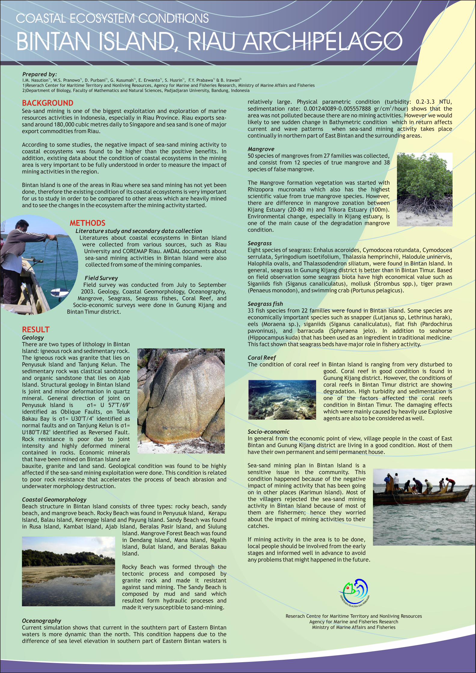
BACKGROUND METHODS RESULT relatively large. Physical parametric condition (turbidity: 0.2-3.3 NTU, 2 sedimentation rate: 0.001240089-0.005557888 gr/cm /hour) shows that the Sea-sand mining is one of the biggest exploitation and exploration of marine area was not polluted because there are no mining activities. However we would resources activities in Indonesia, especially in Riau Province. Riau exports sea- likely to see sudden change in Bathymetric condition which in return affects sand around 180,000 cubic metres daily to Singapore and sea sand is one of major current and wave patterns when sea-sand mining activity takes place export commodities from Riau. continually in northern part of East Bintan and the surrounding areas. According to some studies, the negative impact of sea-sand mining activity to Mangrove coastal ecosystems was found to be higher than the positive benefits. In 50 species of mangroves from 27 families was collected, addition, existing data about the condition of coastal ecosystems in the mining and consist from 12 species of true mangrove and 38 area is very important to be fully understood in order to measure the impact of species of false mangrove. mining activities in the region. The Mangrove formation vegetation was started with Bintan Island is one of the areas in Riau where sea sand mining has not yet been Rhizopora mucronata which also has the highest done, therefore the existing condition of its coastal ecosystems is very important scientific value from true mangrove species. However, for us to study in order to be compared to other areas which are heavily mined there are difference in mangrove zonation between and to see the changes in the ecosystem after the mining activity started. Kijang Estuary (20-80 m) and Trikora Estuary (100m). Environmental change, especially in Kijang estuary, is one of the main cause of the degradation mangrove condition. Literature study and secondary data collection Literatures about coastal ecosystems in Bintan Island Seagrass were collected from various sources, such as Riau Eight species of seagrass: Enhalus acoroides, Cymodocea rotundata, Cymodocea University and COREMAP Riau. AMDAL documents about serrulata, Syringodium isoetifolium, Thalassia hemprinchii, Halodule uninervis, sea-sand mining activities in Bintan Island were also Halophila ovalis, and Thalassodendron siliatum, were found in Bintan Island. In collected from some of the mining companies. general, seagrass in Gunung Kijang district is better than in Bintan Timur. Based on field observation some seagrass biota have high economical value such as Field Survey Siganiids fish (Siganus canaliculatus), mollusk (Strombus spp.), tiger prawn Field survey was conducted from July to September (Penaeus monodon), and swimming crab (Portunus pelagicus). 2003. Geology, Coastal Geomorphology, Oceanography, Mangrove, Seagrass, Seagrass fishes, Coral Reef, and Seagrass fish Socio-economic surveys were done in Gunung Kijang and 33 fish species from 22 families were found in Bintan Island. Some species are Bintan Timur district. economically important species such as snapper (Lutjanus sp, Lethrinus harak), eels (Moraena sp.), siganiids (Siganus canaliculatus), flat fish (Pardochirus pavoninus), and barracuda (Sphyraena jelo). In addition to seahorse Geology (Hippocampus kuda) that has been used as an ingredient in traditional medicine. There are two types of lithology in Bintan This fact shown that seagrass beds have major role in fishery activity. Island: igneous rock and sedimentary rock. The igneous rock was granite that lies on Coral Reef Penyusuk Island and Tanjung Kelun. The The condition of coral reef in Bintan Island is ranging from very disturbed to sedimentary rock was clastical sandstone good. Coral reef in good condition is found in and organic sandstone that lies on Ajab Gunung Kijang district. However, the conditions of Island. Structural geology in Bintan Island coral reefs in Bintan Timur district are showing is joint and minor deformation in quartz degradation. High turbidity and sedimentation is mineral. General direction of joint on one of the factors affected the coral reefs o o condition in Bintan Timur. The damaging effects Penyusuk Island is ó1= U 57 T/69 which were mainly caused by heavily use Explosive identified as Oblique Faults, on Teluk o o agents are also to be considered as well. Bakau Bay is ó1= U30 T/4 identified as normal faults and on Tanjung Kelun is ó1= o o Socio-economic U180 T/82 identified as Reversed Fault. In general from the economic point of view, village people in the coast of East Rock resistance is poor due to joint Bintan and Gunung Kijang district are living in a good condition. Most of them intensity and highly deformed mineral have their own permanent and semi permanent house. contained in rocks. Economic minerals that have been mined on Bintan Island are Sea-sand mining plan in Bintan Island is a bauxite, granite and land sand. Geological condition was found to be highly sensitive issue in the community. This affected if the sea-sand mining exploitation were done. This condition is related condition happened because of the negative to poor rock resistance that accelerates the process of beach abrasion and impact of mining activity that has been going underwater morphology destruction. on in other places (Karimun Island). Most of the villagers rejected the sea-sand mining Coastal Geomorphology activity in Bintan Island because of most of Beach structure in Bintan Island consists of three types: rocky beach, sandy them are fishermen; hence they worried beach, and mangrove beach. Rocky Beach was found in Penyusuk Island, Kerapu about the impact of mining activities to their Island, Balau Island, Kerengge Island and Payung Island. Sandy Beach was found catches. in Rusa Island, Kambat Island, Ajab Island, Beralas Pasir Island, and Siulung Island. Mangrove Forest Beach was found If mining activity in the area is to be done, in Dendang Island, Mana Island, Ngalih local people should be involved from the early Island, Bulat Island, and Beralas Bakau stages and informed well in advance to avoid Island. any problems that might happened in the future. Rocky Beach was formed through the tectonic process and composed by granite rock and made it resistant against sand mining. The Sandy Beach is composed by mud and sand which resulted form hydraulic proceses and made it very susceptible to sand-mining. Oceanography Current simulation shows that current in the southtern part of Eastern Bintan waters is more dynamic than the north. This condition happens due to the difference of sea level elevation in southern part of Eastern Bintan waters is Prepared by: 1) 1) 1) 1) 1) 1) 1) 2) I.M. Nasution , W.S. Pranowo , D. Purbani , G. Kusumah , E. Erwanto , S. Husrin , F.Y. Prabawa & B. Irawan 1)Reserach Center for Maritime Territory and Nonliving Resources, Agency for Marine and Fisheries Research, Ministry of Marine Affairs and Fisheries 2)Department of Biology, Faculty of Mathematics and Natural Sciences, Padjadjaran University, Bandung, Indonesia Reserach Centre for Maritime Territory and Nonliving Resources Agency for Marine and Fisheries Research Ministry of Marine Affairs and Fisheries COASTAL ECOSYSTEM CONDITIONS BINTAN ISLAND, RIAU ARCHIPELAGO COASTAL ECOSYSTEM CONDITIONS BINTAN ISLAND, RIAU ARCHIPELAGO
-
Upload
dodolipet69 -
Category
Documents
-
view
493 -
download
2
description
Nasution, I. M., W. S. Pranowo, D. Purbani, G. Kusumah, E. Erwanto, S. Husrin, F. Y. Prabawa, and B. Irawan.: Coastal ecosystem conditions: Bintan Islands, Riau Archipelago, Papers IMFS 2003: International Seminar On Marine & Fisheries. 15-16 December 2003, Jakarta Convention Center. Agency for Marine & Fisheries Research, Ministry of Marine Affairs & Fisheries – Republic of Indonesia. ISBN: 979-98165-1-3.
Transcript of Coastal ecosystem conditions: Bintan Islands, Riau Archipelago
BACKGROUND
METHODS
RESULT
relatively large. Physical parametric condition (turbidity: 0.2-3.3 NTU, 2sedimentation rate: 0.001240089-0.005557888 gr/cm /hour) shows that the Sea-sand mining is one of the biggest exploitation and exploration of marine
area was not polluted because there are no mining activities. However we would resources activities in Indonesia, especially in Riau Province. Riau exports sea-likely to see sudden change in Bathymetric condition which in return affects sand around 180,000 cubic metres daily to Singapore and sea sand is one of major current and wave patterns when sea-sand mining activity takes place export commodities from Riau.continually in northern part of East Bintan and the surrounding areas.
According to some studies, the negative impact of sea-sand mining activity to Mangrovecoastal ecosystems was found to be higher than the positive benefits. In 50 species of mangroves from 27 families was collected, addition, existing data about the condition of coastal ecosystems in the mining and consist from 12 species of true mangrove and 38 area is very important to be fully understood in order to measure the impact of species of false mangrove. mining activities in the region.
The Mangrove formation vegetation was started with Bintan Island is one of the areas in Riau where sea sand mining has not yet been Rhizopora mucronata which also has the highest done, therefore the existing condition of its coastal ecosystems is very important scientific value from true mangrove species. However, for us to study in order to be compared to other areas which are heavily mined there are difference in mangrove zonation between and to see the changes in the ecosystem after the mining activity started.Kijang Estuary (20-80 m) and Trikora Estuary (100m). Environmental change, especially in Kijang estuary, is one of the main cause of the degradation mangrove condition. Literature study and secondary data collection
Literatures about coastal ecosystems in Bintan Island Seagrasswere collected from various sources, such as Riau Eight species of seagrass: Enhalus acoroides, Cymodocea rotundata, Cymodocea University and COREMAP Riau. AMDAL documents about serrulata, Syringodium isoetifolium, Thalassia hemprinchii, Halodule uninervis, sea-sand mining activities in Bintan Island were also Halophila ovalis, and Thalassodendron siliatum, were found in Bintan Island. In collected from some of the mining companies.general, seagrass in Gunung Kijang district is better than in Bintan Timur. Based on field observation some seagrass biota have high economical value such as Field SurveySiganiids fish (Siganus canaliculatus), mollusk (Strombus spp.), tiger prawn Field survey was conducted from July to September (Penaeus monodon), and swimming crab (Portunus pelagicus). 2003. Geology, Coastal Geomorphology, Oceanography,
Mangrove, Seagrass, Seagrass fishes, Coral Reef, and Seagrass fishSocio-economic surveys were done in Gunung Kijang and 33 fish species from 22 families were found in Bintan Island. Some species are Bintan Timur district.economically important species such as snapper (Lutjanus sp, Lethrinus harak), eels (Moraena sp.), siganiids (Siganus canaliculatus), flat fish (Pardochirus pavoninus), and barracuda (Sphyraena jelo). In addition to seahorse
Geology (Hippocampus kuda) that has been used as an ingredient in traditional medicine. There are two types of lithology in Bintan This fact shown that seagrass beds have major role in fishery activity. Island: igneous rock and sedimentary rock. The igneous rock was granite that lies on Coral ReefPenyusuk Island and Tanjung Kelun. The The condition of coral reef in Bintan Island is ranging from very disturbed to sedimentary rock was clastical sandstone good. Coral reef in good condition is found in and organic sandstone that lies on Ajab Gunung Kijang district. However, the conditions of Island. Structural geology in Bintan Island coral reefs in Bintan Timur district are showing is joint and minor deformation in quartz degradation. High turbidity and sedimentation is mineral. General direction of joint on one of the factors affected the coral reefs
o o condition in Bintan Timur. The damaging effects Penyusuk Island is ó1= U 57 T/69 which were mainly caused by heavily use Explosive identified as Oblique Faults, on Teluk
o o agents are also to be considered as well.Bakau Bay is ó1= U30 T/4 identified as normal faults and on Tanjung Kelun is ó1=
o o Socio-economicU180 T/82 identified as Reversed Fault. In general from the economic point of view, village people in the coast of East Rock resistance is poor due to joint Bintan and Gunung Kijang district are living in a good condition. Most of them intensity and highly deformed mineral have their own permanent and semi permanent house. contained in rocks. Economic minerals
that have been mined on Bintan Island are Sea-sand mining plan in Bintan Island is a bauxite, granite and land sand. Geological condition was found to be highly sensitive issue in the community. This affected if the sea-sand mining exploitation were done. This condition is related condition happened because of the negative to poor rock resistance that accelerates the process of beach abrasion and impact of mining activity that has been going underwater morphology destruction.on in other places (Karimun Island). Most of the villagers rejected the sea-sand mining Coastal Geomorphologyactivity in Bintan Island because of most of Beach structure in Bintan Island consists of three types: rocky beach, sandy them are fishermen; hence they worried beach, and mangrove beach. Rocky Beach was found in Penyusuk Island, Kerapu about the impact of mining activities to their Island, Balau Island, Kerengge Island and Payung Island. Sandy Beach was found catches.in Rusa Island, Kambat Island, Ajab Island, Beralas Pasir Island, and Siulung
Island. Mangrove Forest Beach was found If mining activity in the area is to be done, in Dendang Island, Mana Island, Ngalih local people should be involved from the early Island, Bulat Island, and Beralas Bakau stages and informed well in advance to avoid Island.any problems that might happened in the future.
Rocky Beach was formed through the tectonic process and composed by granite rock and made it resistant against sand mining. The Sandy Beach is composed by mud and sand which resulted form hydraulic proceses and made it very susceptible to sand-mining.
OceanographyCurrent simulation shows that current in the southtern part of Eastern Bintan waters is more dynamic than the north. This condition happens due to the difference of sea level elevation in southern part of Eastern Bintan waters is
Prepared by:1) 1) 1) 1) 1) 1) 1) 2)
I.M. Nasution , W.S. Pranowo , D. Purbani , G. Kusumah , E. Erwanto , S. Husrin , F.Y. Prabawa & B. Irawan1)Reserach Center for Maritime Territory and Nonliving Resources, Agency for Marine and Fisheries Research, Ministry of Marine Affairs and Fisheries2)Department of Biology, Faculty of Mathematics and Natural Sciences, Padjadjaran University, Bandung, Indonesia
Reserach Centre for Maritime Territory and Nonliving ResourcesAgency for Marine and Fisheries ResearchMinistry of Marine Affairs and Fisheries
COASTAL ECOSYSTEM CONDITIONS
BINTAN ISLAND, RIAU ARCHIPELAGOCOASTAL ECOSYSTEM CONDITIONS
BINTAN ISLAND, RIAU ARCHIPELAGO