Modelling The Effect Of Batam Bintan Bridges
10
MODELING THE EFFECT OF BATAM-BINTAN BRIDGES TO ECONOMIC, POPULATION, AND LAND USE ASPECT IN BATAM AND BINTAN ISLAND Tengku Munawar CHALIL Staf of Directorate Local Autonomy Affair Deputy for Regional Development and Local Autonomy Affair National Development Planning Agency (BAPPENAS) Jakarta, Indonesia Email: [email protected] ABSTRACT Batam and Bintan are free trade zone and free seaport that prepared to become a major economic growth center of the Riau Islands Provinces. Batam continues to grow rapidly but the limitations of land and lack of access to the hinterland areas are the development problems. Then development in Bintan island still far left behind compared to Batam and Bintan is not ready yet to become a free trade area. Therefore to answer the problem, Batam-Bintan bridges are planned to build with the goal of equitable development between regions of Batam and Bintan island. There is two scenarios to see the impact of Batam-Bintan bridges (BBB). In the first scenario where Batam-Bintan not exist, Batam grows rapidly but its growth slowed at the end of the simulation due to the limited carrying capacity of land led to declining growth of Batam. In addition, Bintan Growth slowly increased until 25 years later, in the end the growth has not been able equal with Batam growth today. In the second scenario where Batam-Bintan Bridges exist, the behavior of the dynamic model of Batam and Bintan show the effect of Batam-Bintan bridges, there are three effects of the multiplier effect, spin-off effect and spill-over effect. Each of these effects have a positive impact on the city of Batam and Bintan regency. Keywords: system dynamic, demography, economy, land use. Introduction The ratification Law 46/2007 and Law 47/2007 about free trade zone and free seaport in Batam and Bintan and Law 28/2008 about national spatial development plan, Batam and Bintan island being prepared to become one of national economic frontline area. Therefore, needed much infrastructure to support development in Batam and Bintan, and the one if infrastructure whom become concerned are Batam-Bintan Bridges (BBB). The plan of Batam-Bintan Bridges are planned in Riau Province Spatial Plan 2008-2028, Batam Spatial Plan 2008-2028, and Bintan Spatial Plan 2008-2028. Thus plan said that Batam-Bintan Bridges developed with purpose enhanced connectivity between Batam and Bintan region area, enhanced economic strategic sector, and increase the investation and enhance regional competences. In spite of that, Batam has grown rapidly in ten years, and in 2009 population in Batam reached 919.449 people with population density 957 people/km 2 . Beside, Bintan grown slowly as in 2009 the population only reached 10% population in Batam, about 127.404 people with population density 64 people/km 2 . It shown that there is no equal growth between Batam and Bintan. This paper shown the model of the effect of Batam-Bintan Bridges to population, economy, and land use aspect in Batam and Bintan. Using System Dynamic Model in Regional Analysis There are many models used to regional analysis, each model has plus and minus to understanding the behaviour of regional dynamics. Wang (1993) in Chunyang et al (2004) said that System Dynamic Models not only explain about relation between system element within different level, but also can deal with dynamic process with feedback. Moreover, it can predict the complex system change under
-
Upload
tengku-munawar-chalil -
Category
Documents
-
view
221 -
download
2
description
Using System Dynamic Model for Predict the Behaviour of Batam and Bintan Regional Dynamics with Batam Bintan Bridges Intervention
Transcript of Modelling The Effect Of Batam Bintan Bridges

MODELING THE EFFECT OF BATAM-BINTAN BRIDGES TO ECONOMIC, POPULATION, AND LAND USE
ASPECT IN BATAM AND BINTAN ISLAND
Tengku Munawar CHALIL Staf of Directorate Local Autonomy Affair
Deputy for Regional Development and Local Autonomy Affair National Development Planning Agency (BAPPENAS)
Jakarta, Indonesia Email: [email protected]
ABSTRACT
Batam and Bintan are free trade zone and free seaport that prepared to become a major economic growth center of the Riau Islands Provinces. Batam continues to grow rapidly but the limitations of land and lack of access to the hinterland areas are the development problems. Then development in Bintan island still far left behind compared to Batam and Bintan is not ready yet to become a free trade area. Therefore to answer the problem, Batam-Bintan bridges are planned to build with the goal of equitable development between regions of Batam and Bintan island.
There is two scenarios to see the impact of Batam-Bintan bridges (BBB). In the first scenario where Batam-Bintan not exist, Batam grows rapidly but its growth slowed at the end of the simulation due to the limited carrying capacity of land led to declining growth of Batam. In addition, Bintan Growth slowly increased until 25 years later, in the end the growth has not been able equal with Batam growth today.
In the second scenario where Batam-Bintan Bridges exist, the behavior of the dynamic model of Batam and Bintan show the effect of Batam-Bintan bridges, there are three effects of the multiplier effect, spin-off effect and spill-over effect. Each of these effects have a positive impact on the city of Batam and Bintan regency. Keywords: system dynamic, demography, economy, land use. Introduction The ratification Law 46/2007 and Law 47/2007 about free trade zone and free seaport in Batam and Bintan and Law 28/2008 about national spatial development plan, Batam and Bintan island being prepared to become one of national economic frontline area. Therefore, needed much infrastructure to support development in Batam and Bintan, and the one if infrastructure whom become concerned are Batam-Bintan Bridges (BBB). The plan of Batam-Bintan Bridges are planned in Riau Province Spatial Plan 2008-2028, Batam Spatial Plan 2008-2028, and Bintan Spatial Plan 2008-2028. Thus plan said that Batam-Bintan Bridges developed with purpose enhanced connectivity between Batam and Bintan region area, enhanced economic strategic sector, and increase the investation and enhance regional competences. In spite of that, Batam has grown rapidly in ten years, and in 2009 population in Batam reached 919.449 people with population density 957 people/km2. Beside, Bintan grown slowly as in 2009 the population only reached 10% population in Batam, about 127.404 people with population density 64 people/km2. It shown that there is no equal growth between Batam and Bintan. This paper shown the model of the effect of Batam-Bintan Bridges to population, economy, and land use aspect in Batam and Bintan. Using System Dynamic Model in Regional Analysis There are many models used to regional analysis, each model has plus and minus to understanding the behaviour of regional dynamics. Wang (1993) in Chunyang et al (2004) said that System Dynamic Models not only explain about relation between system element within different level, but also can deal with dynamic process with feedback. Moreover, it can predict the complex system change under
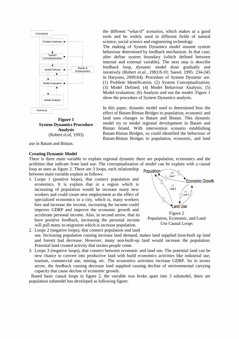
the different “what-if” scenarios, which makes ut a good tools and be widely used in different fields of natural science, social science and engineering technology. The making of System Dynamics model assume system behaviour determined by feedback mechanism. In that case, after define system boundary (which defined between internal and external variable). The next step is describe feedback loop, dynamic model done gradually and iteratively (Robert et.al., 1983:8-10; Saeed, 1995: 234-245 in Haryono, 2009:64). Procedure of System Dynamic are: (1) Problem Identification; (2) System Conceptualization; (3) Model Defined; (4) Model Behaviour Analysis; (5) Model evaluation; (6) Analysis and use the model. Figure 1 show the procedure of System Dynamics analysis. In this paper, dynamic model used to determined how the effect of Batam-Bintan Bridges to population, economic and land uses changes in Batam and Bintan. This dynamic model try to model regional development in Batam and Bintan Island. With intervention scenario establishing Batam-Bintan Bridges, so could identified the behaviour of Batam-Bintan Bridges to population, economic, and land
use in Batam and Bintan. Creating Dynamic Model There is three main variable to explain regional dynamic there are population, economics and the actibities that indicate from land use. The conceptualization of model can be explain with a causal loop as seen as figure 2. There are 3 loops, each relationship between main variable explain as follows: 1. Loops 1 (positive loops), that connect population and
economics. It is explain that in a region which is increasing of population would be increase many new workers and could create new employment as the effect of specialized economics in a city, which is, many workers hire and increase the income, increasing the income could improve GDRP and improve the economic growth and accelerate personal income. Also, in second arrow, that its have positive feedback, increasing the personal income will pull many in-migration which is increase population.
2. Loops 2 (negative loops), that connect population and land use. Increasing population causing increase land demand, makes land supplied (non-built up land and forest) had decrease. However, many non-built-up land would increase the population. Potential land created activity that invites people come.
3. Loops 3 (negative loops), that connect between economic and land use. The potential land can be new chance to convert into productive land with build economics activities like industrial use, tourism, commercial use, mining, etc. The economics activities increase GDRP. So in invers arrow, the feedback causing decrease land supplied causing decline of environmental carrying capacity that cause decline of economic growth.
Based basic causal loops in figure 2, the variable was broke apart into 3 submodel, there are population submodel has developed as following figure:
Problem Definiton
System Conceptualization
Model Defined
Model Evaluation
Model Analysis
Repair & Enhancement
Conceptual
Technical
Figure 1 System Dynamics Procedure
Analysis (Robert et.al, 1993)
Figure 2 Population, Economic, and Land
Use Causal Loops
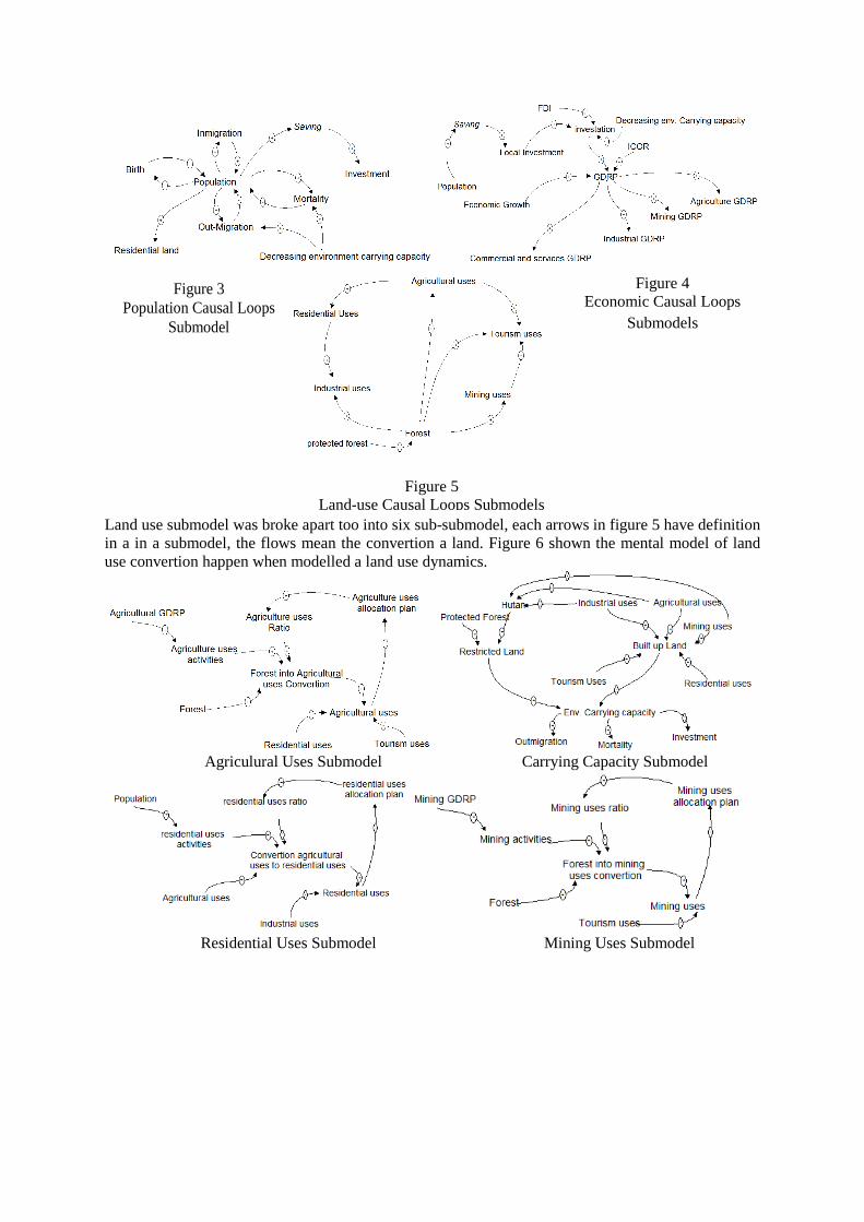
Land use submodel was broke apart too into six sub-submodel, each arrows in figure 5 have definition in a in a submodel, the flows mean the convertion a land. Figure 6 shown the mental model of land use convertion happen when modelled a land use dynamics.
Agriculural Uses Submodel Carrying Capacity Submodel
Residential Uses Submodel Mining Uses Submodel
Figure 3 Population Causal Loops
Submodel
Figure 4 Economic Causal Loops
Submodels
Figure 5 Land-use Causal Loops Submodels

Industrial Uses Submodel Tourism and Commercial uses
Figure 6 Sub-Submodel Landuse convertion.
By combining each submodel and connect them into one system, this paper try to translate the mental model into Stock and Flows diagram using PowerSim Constructor. The software are helpfull to develop SFD model that shown on figure 7.
Figure 7
Stock and Flows Model Population, Economics, and Landuse changes
(Chalil, 2011) Evaluating system dynamics model in this paper using static method by Root-Mean Square Percent Error (RMSPE) with formula:
�1�����−�� � ���

The method compare between paper examine three variables to verificated,for predict urban and regional dynamic in Batam and Bintan. Batam-Bintan Bridges (BBB) pIn Indonesia, the regulation of spatial planning and development planning have legal base in Law 17 /2005 on National Long-Term Development Planwhere diferentiate in Government RegulGovernment Regulation No.26 years 2008 there is stated that Strategic Economic Zone in Indonesia have a following criteria:
a. Have a potential rapidly economic growth.b. Have a leading sector which can motorc. Have export potential d. Supported by infrastructure and economic activity support facilitye. Have a high tech that support economic activity
Batam and Bintan are categorized as one of national economic zone in Indonesia and the one special economic zone (KEK). Thrice with Karimun District, that make thus three island are spearhead of Indonesia economic development againts Singapore and Malaysialocation among two developed country (Malaysia and Singapore) establish a one investment region which mean that three region has between three country named as SIJORI Triangle.
(a) Batam , (b) Batam-Bintan Bridges; (c) Land Use in Batam and Bintan.
Batam is categorized as big cities in Indonesia, and the biggest cities in Kepulauan Riau Provinces. Population in Batam are 992.095 with average growth rate is 10,59%Indonesia with the population in near future reach one million resident with population density near nine-hundred residents par squaresector, and the second is commercial sector. That is prove that Batam has industrial sector as basic sector dan generate economic in its region.
The method compare between simulated data and factual data for verification of the model. This paper examine three variables to verificated, The RMSPE is below 10% so the model can be accepted for predict urban and regional dynamic in Batam and Bintan.
(BBB) project in Batam and Bintan In Indonesia, the regulation of spatial planning and development planning have legal base in Law 17
Term Development Plan 2005-2025 and Law 26/2007 where diferentiate in Government Regulation No.26 years 2008 on National Spatial Plan. In Government Regulation No.26 years 2008 there is stated that Strategic Economic Zone in Indonesia
Have a potential rapidly economic growth. Have a leading sector which can motorize national economic growth
Supported by infrastructure and economic activity support facility Have a high tech that support economic activity
Batam and Bintan are categorized as one of national economic zone in Indonesia and the one special economic zone (KEK). Thrice with Karimun District, that make thus three island are spearhead of Indonesia economic development againts Singapore and Malaysia in Malacca Strait. location among two developed country (Malaysia and Singapore) establish a one investment region which mean that three region has cooperation without limited by country boundary. This cooperation
as SIJORI Triangle.
Figure 8 (a) Batam , Bintan, and Karimun District Orientation;
Bintan Bridges; (c) Land Use in Batam and Bintan.
Batam is categorized as big cities in Indonesia, and the biggest cities in Kepulauan Riau Provinces. Population in Batam are 992.095 residents in 2009. The population in Batam District gr
10,59%, that can be assumed Batam will be a metropolitan cities in Indonesia with the population in near future reach one million resident with population density near
hundred residents par square-kilometres, with Main employeer sector in Batam is industrisector, and the second is commercial sector. That is prove that Batam has industrial sector as basic sector dan generate economic in its region. Batam also has rapid economic growth, as shown,
simulated data and factual data for verification of the model. This The RMSPE is below 10% so the model can be accepted
In Indonesia, the regulation of spatial planning and development planning have legal base in Law 17 2025 and Law 26/2007 on Spatial Planning
on National Spatial Plan. In Government Regulation No.26 years 2008 there is stated that Strategic Economic Zone in Indonesia
Batam and Bintan are categorized as one of national economic zone in Indonesia and the one special economic zone (KEK). Thrice with Karimun District, that make thus three island are spearhead of
in Malacca Strait. The strategic location among two developed country (Malaysia and Singapore) establish a one investment region
without limited by country boundary. This cooperation
Bintan Bridges; (c) Land Use in Batam and Bintan.
Batam is categorized as big cities in Indonesia, and the biggest cities in Kepulauan Riau Provinces. The population in Batam District grew rapidly
, that can be assumed Batam will be a metropolitan cities in Indonesia with the population in near future reach one million resident with population density near
er sector in Batam is industrial sector, and the second is commercial sector. That is prove that Batam has industrial sector as basic
Batam also has rapid economic growth, as shown,
economic growh rate in Batam in 2008 reach 7,52% which is bcan be seen, main land use in Batam is industrial uses that almost covers 30% of the land. Industrial uses is the fastest convertion rate compared other, in 2010 the industrial convertion rate is 943,73 Ha/years. Otherwise, Bintan not as growth as Batam. The population there only 127.404 resident in 2009, the population grew slowly with average growth rate is 1,86%. The population density is only 64 residents par square-kilometres. Main employeer sector in Bintan is one is commercial sector. The economic growth in Bintan in year 2009 only grew 5,11%slightly above average national economic growth 4,4%. 19,34% of the land uses in Bintanin Bintan, only cover 176,49 Ha in 2007. In case for created balanced growth between thus two island, government of Kepulauan Riau Provinces plan to connect BatamBridges. Batam-Bintan bridges are created with purpose as follows:
a. Created new growth pole with increase the accesibility in Batam, Bintan, and around. b. Balancing interregional development with the result th
become more fluently. c. Increasing the development of strategic sector in the region for enhance investation and
increase regional competencesd. Become a role model for inter
Cost for creating Batam-Bintan bridges need investation Rp 3.175 Trillion or US$ 317,5 million. Budgetting method for create the bridges is Transfer (BOT).
Using System Dynamic Model for Regional Dynamic (Batam and Bintan Island)By using System Dynamic Model which has developed beand Bintan island are divided into two scenario; (1) Regional dynamic iwithout Batam and Bintan Bridges, and (2) Regional dynamic in Batam and Bintan with Batam and Bintan Bridges which is divided again into 3 (three) subScenario, (2) Moderate Scenario, and (3) Optimistic Scenario The period of simulation model Bintan Bridges are established in 2015. And every variable outside system boundary (national growth rate, government regulation, birth and mortality indices, etc) arfixed and nothing changes. First, the regional dynamic in Batam and Bintan Island without Batam and Bintan Bridges Scenario. Total population in Batam increased as usual with population growth rate 12,8% and in the end of simulation (2027)times more than total population in 2007) with population density 6.231 people par square
economic growh rate in Batam in 2008 reach 7,52% which is bigger than national growth rate. As seen, main land use in Batam is industrial uses that almost covers 30% of the land. Industrial
uses is the fastest convertion rate compared other, in 2010 the industrial convertion rate is 943,73
Bintan not as growth as Batam. The population there only 127.404 resident in 2009, the population grew slowly with average growth rate is 1,86%. The population density is only 64
kilometres. Main employeer sector in Bintan is Industrial sector, and the second The economic growth in Bintan in year 2009 only grew 5,11%
slightly above average national economic growth 4,4%. Contrastly with the land use in Bintan, 19,34% of the land uses in Bintan is agricultural uses, but industrial uses, which in Bintan, only cover 176,49 Ha in 2007.
In case for created balanced growth between thus two island, government of Kepulauan Riau Provinces plan to connect Batam-Bintan using road infrastructure, one main project is Batam
Bintan bridges are created with purpose as follows: Created new growth pole with increase the accesibility in Batam, Bintan, and around. Balancing interregional development with the result that the flow of people and goods
Increasing the development of strategic sector in the region for enhance investation and increase regional competences Become a role model for inter-island transportation infrastructure in Indonesia.
Bintan bridges need investation Rp 3.175 Trillion or US$ 317,5 million. Budgetting method for create the bridges is Public-Private Partnership (PPP)
Figure 9
Ilustration of Batam-Bintan Bridges (Bappeda Kep. Riau, 2009)
Using System Dynamic Model for Regional Dynamic (Batam and Bintan Island)ic Model which has developed before, regional dynamic in Batam
and Bintan island are divided into two scenario; (1) Regional dynamic in Batam and Bintan without Batam and Bintan Bridges, and (2) Regional dynamic in Batam and Bintan with
which is divided again into 3 (three) sub-scenario: (1) Pessimistic Scenario, (2) Moderate Scenario, and (3) Optimistic Scenario.
model are 20 years (2007-2027) and the model assumption BatamBintan Bridges are established in 2015. And every variable outside system boundary
th rate, government regulation, birth and mortality indices, etc) ar
First, the regional dynamic in Batam and Bintan Island without Batam and Bintan Bridges Scenario. Total population in Batam increased as usual with population growth rate 12,8% and in the end of simulation (2027) total population in Batam reach 6.481.211 people (9 times more than total population in 2007) with population density 6.231 people par square
igger than national growth rate. As seen, main land use in Batam is industrial uses that almost covers 30% of the land. Industrial
uses is the fastest convertion rate compared other, in 2010 the industrial convertion rate is 943,73
Bintan not as growth as Batam. The population there only 127.404 resident in 2009, the population grew slowly with average growth rate is 1,86%. The population density is only 64
sector, and the second The economic growth in Bintan in year 2009 only grew 5,11% which mean
Contrastly with the land use in Bintan, , which is the leading sector
In case for created balanced growth between thus two island, government of Kepulauan Riau infrastructure, one main project is Batam-Bintan
Created new growth pole with increase the accesibility in Batam, Bintan, and around. at the flow of people and goods
Increasing the development of strategic sector in the region for enhance investation and
island transportation infrastructure in Indonesia. Bintan bridges need investation Rp 3.175 Trillion or US$ 317,5 million.
Private Partnership (PPP) by Build-Operate-
Using System Dynamic Model for Regional Dynamic (Batam and Bintan Island) fore, regional dynamic in Batam
n Batam and Bintan without Batam and Bintan Bridges, and (2) Regional dynamic in Batam and Bintan with
scenario: (1) Pessimistic
assumption Batam-Bintan Bridges are established in 2015. And every variable outside system boundary
th rate, government regulation, birth and mortality indices, etc) are assumed
First, the regional dynamic in Batam and Bintan Island without Batam and Bintan Bridges Scenario. Total population in Batam increased as usual with population growth rate 12,8%
l population in Batam reach 6.481.211 people (9 times more than total population in 2007) with population density 6.231 people par square-

kilometres. Meanwhile, total population in Bintan still grow slowly with rate 1,9% and in the end of simulation total population in Bintan is 178.481 peopeople par square-kilometres. In that case, there are a very imbalance growth between Batam in Bintan in next 20 years without connected by Batam In economic aspect, investation in Batam grow with rate 12,87% that make in the end of simulation total investation in Batam grow twice than total investation in 2007 and GDRP grow thrice compared with GDRP in first year (2007). Meanwhile, in Bintan investation grow 8,3 times and GDRP grow 8,2 times. Also in land use aspect, grow of economic and population in Batam increase the amount of total built up land decrease the nonBatam has reach the limit that make the developmesimulation in Batam, many land use have reach the limit of total alocation that permitted like industrial uses, residential uses, commercial and tourism uses, meanwhile the demand of land can not be stop that make incomfortof total built up land did not make any trouble because 20 years into the future, availability of land still enough for supply land demand. Dynamic of the population, economic, and land use in Batam and Bintan shown in figure 10
Population (RMSPE: 9,35%)without Batam
kilometres. Meanwhile, total population in Bintan still grow slowly with rate 1,9% and in the l population in Bintan is 178.481 people with population density 64
kilometres. In that case, there are a very imbalance growth between Batam ext 20 years without connected by Batam-Bintan Bridges.
station in Batam grow with rate 12,87% that make in the end of simulation total investation in Batam grow twice than total investation in 2007 and GDRP grow thrice compared with GDRP in first year (2007). Meanwhile, in Bintan investation
GDRP grow 8,2 times.
Also in land use aspect, grow of economic and population in Batam increase the amount of total built up land decrease the non-built up land, till the end of 2016, carrying capacity in Batam has reach the limit that make the development in Batam decline. In land use simulation in Batam, many land use have reach the limit of total alocation that permitted like industrial uses, residential uses, commercial and tourism uses, meanwhile the demand of land can not be stop that make incomfortable activities in Batam. Meanwhile, increase the amounr f total built up land did not make any trouble because 20 years into the future, availability of
land still enough for supply land demand. Dynamic of the population, economic, and land use and Bintan shown in figure 10 and figure 11.
Figure 10 9,35%), Economic (RMSPE: 3,23%) and Landuse Dynamic in Batam
without Batam-Bintan Bridges Scenario
kilometres. Meanwhile, total population in Bintan still grow slowly with rate 1,9% and in the ple with population density 64
kilometres. In that case, there are a very imbalance growth between Batam
station in Batam grow with rate 12,87% that make in the end of simulation total investation in Batam grow twice than total investation in 2007 and GDRP grow thrice compared with GDRP in first year (2007). Meanwhile, in Bintan investation
Also in land use aspect, grow of economic and population in Batam increase the amount of till the end of 2016, carrying capacity in
nt in Batam decline. In land use simulation in Batam, many land use have reach the limit of total alocation that permitted like industrial uses, residential uses, commercial and tourism uses, meanwhile the demand of land
able activities in Batam. Meanwhile, increase the amounr f total built up land did not make any trouble because 20 years into the future, availability of
land still enough for supply land demand. Dynamic of the population, economic, and land use
and Landuse Dynamic in Batam

Population (RMSPE: 0,56%), Economic (RMSPE: without Batam
After using system dynamic in the scenario without Batamscenario is using Batam-Bintan Bridges to understood the effect of BatamBatam and Bintan development. The intervention in the model using a intervention submodel in economic, population and land use. The effect of Batamthree sub-scenario: (1) Pessimistic; (2) Moderate; and (3) Optimistic Scenario. Aftethe model, the effect has resume in table 1 below.
Table 1: Effect of Batam
Condition
Without BBB
Pre-Condition
Batam (2027)
Population
1 Total Population 6481211
Regional Economics
1 Investation (Billion Rupiah)
301682
2 GDRP (Billion Rupiah)
63019
Land Uses
1 Forestry (Ha) 19857,43
2 Residential Uses (Ha)
20435,87
3 Industrial Uses (Ha) 11959
4 Tourism and Commercial Uses (Ha)
10289,43
5 Agricultural Uses (Ha)
6724,16
Figure 11 %), Economic (RMSPE: 5,76%) and Landuse Dynamic in Bintan without Batam-Bintan Bridges Scenario
After using system dynamic in the scenario without Batam-Bintan Bridges, the second Bintan Bridges to understood the effect of Batam
d Bintan development. The intervention in the model using a intervention submodel in economic, population and land use. The effect of Batam-Bintan Bridges are divided into
scenario: (1) Pessimistic; (2) Moderate; and (3) Optimistic Scenario. Aftethe model, the effect has resume in table 1 below.
Table 1: Effect of Batam-Bintan Bridges Without BBB Changes of Precondition because BBB Affect
Condition Pessimistic Scenario Moderat Scenario
Bintan (2027)
Batam (2027)
Bintan (2027)
Batam (2027)
Bintan (2027)
178481 -25,0% +142% -44% +133%
1135,8 -6,00% +14% -9,70% +21%
14516,49 -5,28% +3,69% +0,4% +1,41%
45930,29 +0,76% -5,74% -0,80% -6,32%
1838,69 -0,47% +222,17% -2,22% +210,09%
7729,48 -0,04% +4,87% +0,2% +8,22%
20181,56 -0,03% +3,52% +8,5% +6,03%
31228,66 -0,46% +7,8% +7,47% -8,30%
%) and Landuse Dynamic in Bintan
Bintan Bridges, the second Bintan Bridges to understood the effect of Batam-Bintan Bridges in
d Bintan development. The intervention in the model using a intervention submodel Bintan Bridges are divided into
scenario: (1) Pessimistic; (2) Moderate; and (3) Optimistic Scenario. After running
Changes of Precondition because BBB Affect
Optimistic Scenario
Batam (2027)
Bintan (2027)
-61,2% +125%
-13% +29,3%
+37,3% -0,53%
-8,25% +6,7%
+210,09% -7,97% +197,67%
+1,12% +10,95%
+2,09% +8%
+39,3% -8,64%

Condition
Without BBB Changes of Precondition because BBB Affect
Pre-Condition Pessimistic Scenario
Moderat Scenario Optimistic Scenario
Batam (2027)
Bintan (2027)
Batam (2027)
Bintan (2027)
Batam (2027)
Bintan (2027)
Batam (2027)
Bintan (2027)
6 Mining Uses (Ha) 5739,9 12331,33 -0,20% -0,70% +1,43% -1,70% +7,84% -8,64%
There are three effect identified in thus three scenario: (1) Spin-Off Effect; (2) Spill-Over Effect; and (3) Multiplier Effect. Multiplier effect shown by rapid increase in GDRP and Investation in Bintan when Batam-Bintan Bridges already established in 2015. In running simulation, in pessimistic, moderate and optimistic scenario investation in Bintan increase 14%, 21% and 29,3% from pre-condition scenario without Batam-Bintan Bridges. Meanwhile, investation in Batam decrease slightly compared with pre-condition scenario. Decrease in Batam in pessimistic, moderate and optimistic scenario are -6,9%, -9,7 and -13%. In simulation conlude that multiplier effect is lost investation in Batam give a multiply 2-3 times increase investation in Bintan. Spill-over effect, this effect indicated with rapidly grow of industrial uses in Bintan shown the fluently flow of goods which is make industry search a new land to start production activity. Meanwhile, flow of human shown in rapid migration in Bintan which can be seen in increase of total population in Bintan and slightly decrease of total population in Batam. That conclude Batam-Bintan Bridges make access of transportation to go cross Batam and Bintan make easy. Spin-Off effect, which show with enhanced industrial sector in Batam and Bintan, also enhanced tourism and commercial sector in Bintan, that indicated increasingly of GDRP and increase of built up land. This positive impact show the potent Batam-Bintan Bridges to enhance strategic economic sector in Batam and Bintan. Conclusion To determine the effect of Batam-Bintan Bridges in Batam and Bintan development , this paper use system dynamic model analysis with intervention scenario. System dynamic analysis useful to predict regional dynamic. This paper using 2 scenario, a scenario in Batam and Bintan without Batam-Bintan Bridges else a scenario in Batam-Bintan with Batam-Bintan Bridges which divided into 3 sub-scenario: (1) pesimistic scenario; (2) moderate scenario and (3) optimistic scenario. By running the model, can be seen Batam-Bintan Bridges have a good impact in Batam and Bintan development. As can be shown, Batam-Bintan Bridges create a balance between Batam and Bintan. When established, Batam-Bintan Bridges increase the economic growth and population in Bintan, also push the economic strategic sector both off two island. Batam are pushed in Industrial sector and Bintan are pushed in tourism and commercial sector. The effect are identified are multiplier effect, spill-over effect, and spin-off effect. The effect is have to be supported by national, provincial and local government by regulation, the regulation are: 1. Using Batam-Bintan bridges for strengthening strategic sector in Batam and Bintan, and
develop industrial zone in Batam-Tanjung Sauh-Bintan as main industrial sector between two island and Batam-Bintan Bridges as backbone infrastructure.

2. Create economic forward-backward linkages between Batam and Bintan, push the economic strategic sector based insentive, and connected the growth pole in Batam and Bintan.
3. Ensure land use activity in Batam and Bintan for not exceed than carrying capacity both two island, controlling spatial plan for prevent urban sprawl and make sure intensification of land uses.
Acknowledgement: This paper based on the writer post-graduate research thesis in Department of Regional and City Planning, Bandung Institute Technology, Indonesia. References Forester, J.W. 1982. Principle of System. Second Preliminary Edition of Management.
Massachusetts and Institute of Technology London, England. Model Dinamika Perkotaan.– Ministry of Public Works. Nurzaman, Siti Sutriah.2002. Perencanaan Wilayah di Indonesia pada Masa Sekitar Krisis.
Penerbit ITB: Bandung. Pontoh, Nia.K., Kustiwan, Iwan. 2009. Pengantar Perencanaan Perkotaan. Penerbit ITB:
Bandung. Tasrif, Muhammad. 2005. Analisis Kebijakan Menggunakan Model System Dinamics Modul
Kuliah/Kursus. Program Magister Studi Pembangunan. Bandung. Tamin, Ofyar Z. 1997. Perencanaan Dan Pemodelan Transportasi. Penerbit ITB: Bandung. Tamin, Ofyar Z. 2000. Perencanaan dan Pemodelan Transportasi: contoh soal dan aplikasi.
Penerbit ITB: Bandung. He Chunhyang, Shi Peijun, et al. 2004. Developing Landuse Scenario Dynamic Model by The
Integration of System Dynamics Model and Cellular Autamata Model.Science in China Press - Beijing Normal University; Beijing-China.
Wang, Q., System Dynamics (in Chinese), Beijing: Tsinghua University Press, 1993.