La Plata Basin (LPB) Regional Hydroclimate Project E. Hugo Berbery, co-chair for CLIVAR
Climatology and Hydrology of
the Plata Basin
A Document of VAMOS1 Scientific Study Group on the Plata Basin
C. Roberto Mechoso (Co-Chair, U. California, Los Angeles, USA), Pedro Silva Dias (Co-Chair,U. Sao Paulo, Brazil), Walter Baethgen (INIA, Uruguay), Vicente Barros (U. Buenos Aires,
Argentina), E. Hugo Berbery (U. Maryland, USA), Robin Clarke (U. Federal Rio Grande do Sul,Brazil), Heidi Cullen (IRI, USA), Carlos Ereño (CLIVAR International Project Office),Benjamin Grassi (Universidad Nacional de Asunción, Paraguay), Dennis Lettenmaier
(University of Washington, USA).
August 2001
1The Variability of American Monsoon Systems (VAMOS) Panel is a component of the Climate VariabilityProgram (CLIVAR), under the World Climate Research Programme (WCRP).
1
Table of ContentsPage Number
Preface 3
1. Introduction 41.1. Agriculture 41.2 Energy demand and hydropower 51.2.1 Privatization and Integration 61.3 Transboundary water issues 8
2. Mean Climatology of the Basin 82.1 Low-level circulation 82.2 Moisture flux and sources 112.3 Precipitation 112.4 Temperature 12
3. Mean Hydrology of the Basin 123.1 Sub-basins 123.2 Hydrological regions 153.3 Temporal and spatial variability of hydrological conditions 17
4. Variability of the Basin’s Climate 174.1 Mesoscale variability and the diurnal cycle 174.2 Synoptic scale variability 184.3 Intraseasonal variability 194.4 Interannual variability 194.5 Decadal variability and trends 21
5. Variability of the Basin’s Hydrology 225.1 River flow 225.2 Flood and drought 23
6. Selected Relevant Studies with Numerical Models 236.1 Atmospheric General Circulation Models (AGCMs) 236.2 Mesoscale models 246.3 Hydrological models 246.4 Watershed models 296.5 Hydrodynamical models 31
7. Predictability 327.1 Climate and weather prediction 327.2 Hydrology 32
8. Sensitivity to Climate Change 34
2
9. Environmental Issues 359.1 Land-cover change, deforestation and agricultural production 369.2 Increased urbanization: Natural hazards and vulnerability 379.3 Critical regions for sustainable development 37
10. Application of Climate Forecasts: Case Studies 3710.1 Application of Climate Forecasts to Water Resource Management:a case study of Itaipu 3710.2 Application of Climate Forecasts to Agriculture: a case study of Uruguay 3810.3 Application of Climate Forecasts to Urbanization:a case study of Buenos Aires 39
11. Motivation for an International Program on the Plata River Basin 41
12. Relevance to the World Climate Research Programme (WCRP) 43
13. Outline of an Implementation Plan 4313.1 Enhancement climate and hydrology monitoring 4313.2 Development of a data center in the region 4313.3 Development of regional climate and hydrological predication
centers in the basin 4513.4. Development of a system for information distribution 45
14. Summary 45
References 48

3
Preface
A significant source of natural capital for the growing populations of Argentina, Brazil, Bolivia,Paraguay, and Uruguay, the Plata Basin generates 70% of the total Gross National Product ofthese countries and is critical to local economies as an agricultural center, natural waterway fortransportation, and primary producer of hydroelectric energy. In view of the recent advancesmade in climate and hydrological forecasting, there is potential for improved decision-making insectors such as water resource management and agriculture. In addition, the inhabitants of thePlata Basin, now nearly 60% of the total population of the five countries in the Basin, wouldgreatly benefit by an early warning system to mitigate the impact of extreme events such asdroughts and floods. Finally, there is need to address the significant environmental degradationthat the Basin has experienced in the last decades as a result of land-use alteration and globalclimate change, and of the impacts of economic development.
Four countries in the Basin, Argentina, Brazil, Uruguay, and Paraguay, currently operate as aneconomic common market (MERCOSUR). This is a major effort toward a closer integration oftheir economies. Regional governments are using the framework of MERCOSUR to developcommon socioeconomic policies. The scientific community is also starting to establish regionalcollaborative research activities in the framework of MERCOSUR. The present time, therefore,is especially auspicious for establishing an international program on the climatology andhydrology of the Plata Basin.
The WMO/WCRP CLIVAR panel on the Variability of American Monsoon Systems (VAMOS) hasfound general consensus on the region's readiness to embark on and support collaborativeresearch on the Plata Basin's climate/hydrology. This readiness is primarily due to an enhancedawareness of the impact that climate variations can have on water resource management, energyproduction, agriculture and health. Improved prediction can potentially result in large economicand social benefits to the region.
The Panel at its annual meeting held in Montevideo, Uruguay, March 2001, appointed a VAMOSPlata Basin Scientific Study Group (SSG). Members of the Plata Basin SSG are: WalterBaethgen (INIA, Uruguay), Vicente Barros (U. Buenos Aires, Argentina), E. Hugo Berbery (U.Maryland, USA), Robin Clarke (U. Federal Rio Grande do Sul, Brazil), Heidi Cullen (IRI, USA),Carlos Ereño (International CLIVAR Project Office), Benjamin Grassi (Universidad Nacionalde Asunción, Paraguay), Dennis Lettenmaier (U. Washington, USA), C. Roberto Mechoso (Co-Chair,U. California, Los Angeles, USA), and Pedro Silva Dias (Co-Chair, U. Sao Paulo, Brazil).This document is intended to act as guidance for the design of a comprehensive program for theBasin.
4
1. Introduction
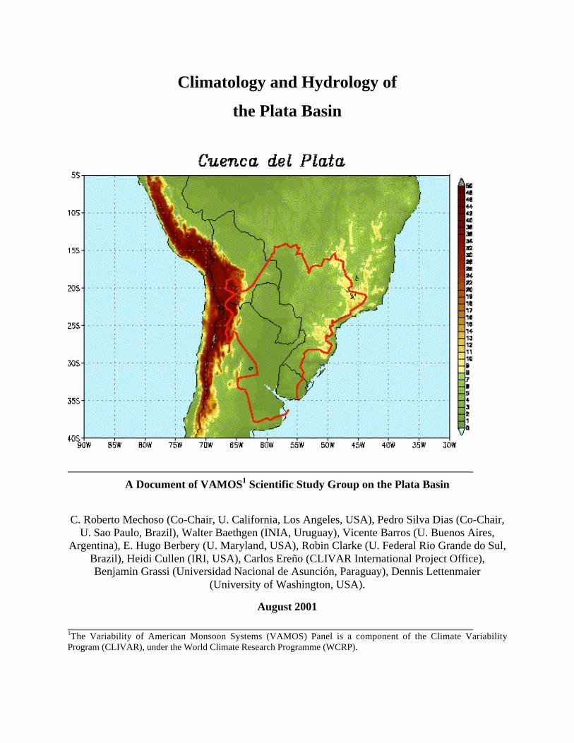
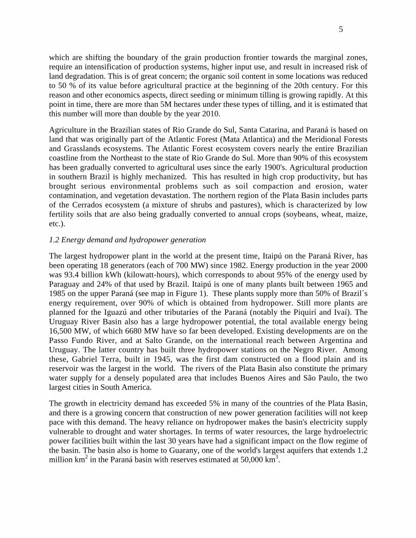
The Plata Basin covers about 3.6 million km2 (see Fig. 1). In terms of geographical extent, thebasin is the fifth largest in the world and second only to the Amazon Basin in South America.The principal sub-basins are those of the Paraná, Paraguay and Uruguay Rivers. The Plata Basincovers parts of five countries, is home to about 50% of their combined population, and generatesabout 70% of their total GNP. Approximately 30% of the area belongs to Argentina, 7% toBolivia, 46% to Brazil, 13% to Paraguay and 4% to Uruguay. The basin is important in differentways for the economies of those countries. Harvests and livestock are among the region's crucialresources, rivers are natural waterways, and surface transportation has greatly increased in recentyears due to the integration of regional economies. Last, but not least, several hydroelectricplants provide most of the energy consumed. The countries in the basin have a history ofinternational collaboration. Argentina and Uruguay built Salto Grande on the Uruguay River.Brazil and Paraguay built today’s largest power station in the world at Itaipú on the ParanáRiver. Argentina and Paraguay built Yacyretá, also a very large power station downstream fromItaipú.
1.1 Agriculture
The Plata Basin is one of the largest food producers (cereals, soybeans and livestock) in theworld. The regional economy is largely based, directly or indirectly, on agriculture (crops andlivestock). Argentinean provinces in the basin produce more than 90% of the country’s cerealand oil crop production, and grow more than 70% of the country's bovines. Brazilian states in thebasin produce more than 30% of the country’s rice, soybeans, wheat, maize, and grow about10% of the country’s bovines. Uruguay produces its entire cereal and oil crop and grows morethan 80% of its livestock in the basin. Paraguay, whose economy largely depends directly orindirectly on agricultural production (90% of which corresponds to livestock), is entirely withinthe basin. This country’s production is about 10 Megatons (Mt), and is increasing due to newtechnologies and the expansion of productive areas.
Agricultural production in the southern region of the Plata Basin primarily develops on thehighly fertile soils of the Pampas, an ecosystem in which native temperate and subtropicalgrasslands have been converted to croplands. Here, climate fluctuations on various time scalesresult in high variability of crop and animal-based production with the potential for negativeconsequences on food supply and on the economy at both regional and national levels. ThePampas extend over 75 million hectares, of which 26 million are cultivated. There has been aconsiderable increment of grain production in the last ten years due to the incorporation ofupdated technology and the revision of inadequate policies for the sector. The mean annualproduction of the Pampas is now more than 50 Mt, varying from 45 to more than 65 Mt in thebest years.
Areas devoted to agriculture in Argentina have steadily increased during the last decade. Plantedareas with grains and oil-seeds increased from 20 up to 26 million hectares. Changes areevidenced mainly in the Pampas, where land use strongly depends on economic conditions.(Cultivated lands increase in detriment of pastures during years with more favorable prices forgrain crops compared with those for cattle). For example, the cultivated area in the province ofBuenos Aires increased 40% between 1988 and 1993. Such changes in land use of the Pampas,
5
which are shifting the boundary of the grain production frontier towards the marginal zones,require an intensification of production systems, higher input use, and result in increased risk ofland degradation. This is of great concern; the organic soil content in some locations was reducedto 50 % of its value before agricultural practice at the beginning of the 20th century. For thisreason and other economics aspects, direct seeding or minimum tilling is growing rapidly. At thispoint in time, there are more than 5M hectares under these types of tilling, and it is estimated thatthis number will more than double by the year 2010.
Agriculture in the Brazilian states of Rio Grande do Sul, Santa Catarina, and Paraná is based onland that was originally part of the Atlantic Forest (Mata Atlantica) and the Meridional Forestsand Grasslands ecosystems. The Atlantic Forest ecosystem covers nearly the entire Braziliancoastline from the Northeast to the state of Rio Grande do Sul. More than 90% of this ecosystemhas been gradually converted to agricultural uses since the early 1900's. Agricultural productionin southern Brazil is highly mechanized. This has resulted in high crop productivity, but hasbrought serious environmental problems such as soil compaction and erosion, watercontamination, and vegetation devastation. The northern region of the Plata Basin includes partsof the Cerrados ecosystem (a mixture of shrubs and pastures), which is characterized by lowfertility soils that are also being gradually converted to annual crops (soybeans, wheat, maize,etc.).
1.2 Energy demand and hydropower generation
The largest hydropower plant in the world at the present time, Itaipú on the Paraná River, hasbeen operating 18 generators (each of 700 MW) since 1982. Energy production in the year 2000was 93.4 billion kWh (kilowatt-hours), which corresponds to about 95% of the energy used byParaguay and 24% of that used by Brazil. Itaipú is one of many plants built between 1965 and1985 on the upper Paraná (see map in Figure 1). These plants supply more than 50% of Brazil´senergy requirement, over 90% of which is obtained from hydropower. Still more plants areplanned for the Iguazú and other tributaries of the Paraná (notably the Piquirí and Ivaí). TheUruguay River Basin also has a large hydropower potential, the total available energy being16,500 MW, of which 6680 MW have so far been developed. Existing developments are on thePasso Fundo River, and at Salto Grande, on the international reach between Argentina andUruguay. The latter country has built three hydropower stations on the Negro River. Amongthese, Gabriel Terra, built in 1945, was the first dam constructed on a flood plain and itsreservoir was the largest in the world. The rivers of the Plata Basin also constitute the primarywater supply for a densely populated area that includes Buenos Aires and São Paulo, the twolargest cities in South America.
The growth in electricity demand has exceeded 5% in many of the countries of the Plata Basin,and there is a growing concern that construction of new power generation facilities will not keeppace with this demand. The heavy reliance on hydropower makes the basin's electricity supplyvulnerable to drought and water shortages. In terms of water resources, the large hydroelectricpower facilities built within the last 30 years have had a significant impact on the flow regime ofthe basin. The basin also is home to Guarany, one of the world's largest aquifers that extends 1.2million km2 in the Paraná basin with reserves estimated at 50,000 km3.
6
1.2.1Privatization and integration
The recent restructuring of the power market within the MERCOSUR countries of Argentina,Brazil, Paraguay, and Uruguay has been designed to make hydropower projects more attractivefor private investors. Currently, construction is ongoing to build Brazil's largest privatizedhydropower project on the Uruguay River called Itá. This is one of the first large dam projectsbeing promoted by the Inter-American Development Bank (IDB), as part of the IDB's newprivate sector funding initiative. Also part of this initiative is the plan for 16 dams in Brazil to beput up for bids by private companies. The predicted growth rate of electricity demand for
7
Southern Brazil, for example, is approximately 5.8% a year, mostly because of massiveinvestment made in growing economic sectors such as the automotive and petrochemicalindustries. Deregulation is one strategy to meet increasing demand. The use of seasonal tointerannual climate forecasts can also help to achieve higher efficiencies in order to better satisfythe increasing demand.
Electricityproduction
(BkWh)
% fromhydropower
(%)
Electricitygenerating
capacity (GW)
% fromhydropower
(%)
ElectricityConsumption
(BkWh)
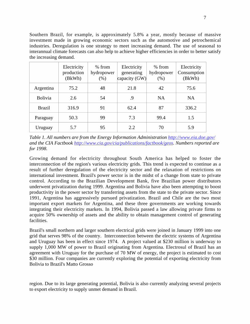
Argentina 75.2 48 21.8 42 75.6
Bolivia 2.6 54 .9 NA NA
Brazil 316.9 91 62.4 87 336.2
Paraguay 50.3 99 7.3 99.4 1.5
Uruguay 5.7 95 2.2 70 5.9
Table 1. All numbers are from the Energy Information Administration http://www.eia.doe.gov/and the CIA Factbook http://www.cia.gov/cia/publications/factbook/geos. Numbers reported arefor 1998.
Growing demand for electricity throughout South America has helped to foster theinterconnection of the region's various electricity grids. This trend is expected to continue as aresult of further deregulation of the electricity sector and the relaxation of restrictions oninternational investment. Brazil's power sector is in the midst of a change from state to privatecontrol. According to the Brazilian Development Bank, five Brazilian power distributorsunderwent privatization during 1999. Argentina and Bolivia have also been attempting to boostproductivity in the power sector by transferring assets from the state to the private sector. Since1991, Argentina has aggressively pursued privatization. Brazil and Chile are the two mostimportant export markets for Argentina, and these three governments are working towardsintegrating their electricity markets. In 1994, Bolivia passed a law allowing private firms toacquire 50% ownership of assets and the ability to obtain management control of generatingfacilities.
Brazil's small northern and larger southern electrical grids were joined in January 1999 into onegrid that serves 98% of the country. Interconnection between the electric systems of Argentinaand Uruguay has been in effect since 1974. A project valued at $230 million is underway tosupply 1,000 MW of power to Brazil originating from Argentina. Electrosul of Brazil has anagreement with Uruguay for the purchase of 70 MW of energy, the project is estimated to cost$30 million. Four companies are currently exploring the potential of exporting electricity fromBolivia to Brazil's Matto Grosso
region. Due to its large generating potential, Bolivia is also currently analyzing several projectsto export electricity to supply unmet demand in Brazil.
8
1.3 Transboundary Water Issues
The sustainable development of limited natural resources hinges upon effective dialoguebetween scientists, policy makers, resource managers, and end-users. The Plata Basin is acomplex system, shaped by both natural processes and human demands, each having both spatialand temporal variability. Transboundary water issues have become a growing concern in SouthAmerica, although this has only 5% of the world's population and 26% of the world's runoff. Asustainable development strategy for border areas must include: (a) diagnostic studies of eacharea, (b) environmental zoning proposals that define areas suitable for sustainable production aswell as areas for environmental protection, (c) integrated programs that form part of an overalldevelopment strategy, and (d) national and binational investment projects formulated at the pre-feasibility and feasibility levels.
2. Mean Climatology of the Basin
2.1 Low-level circulation
The meridional wind field at 850 mb from ECMWF reanalyses shown in Fig. 2 illustrates themost relevant surface circulation features. Winds at that level are northerly over most of thebasin with a maximum in the northwestern sector; northerlies are present throughout the year butare strongest during winter. The northeastern sector shows the signature of the South AtlanticConvergence Zone (SACZ), which has a well-defined annual cycle with strongest intensityduring summer. Estimates of the annual cycle from other global analyses, while similar over theSACZ, can be very different east of the Andes. A similar broad description has been obtained forthe moisture transport field over South America (Nogués-Paegle and Mo, 1997). We will returnto this point later in this document.
The summer circulation over South America is dominated by a monsoon system (SAMS).Important geographical factors determining the monsoon evolution are the large land massbisected by the equator, very high mountains to the west that effectively block air transport in thezonal direction, and surface cover that varies from tropical forests in Amazonia to high altitudedeserts in the Bolivian Altiplano. Plentiful moisture supply from the Atlantic maintains aprecipitation maximum over central Brazil. A major seasonal feature of the monsoonalcirculation over South America is the Southern Atlantic Convergence Zone (SACZ), whichextends southeastward along the northeastern boundary of the Plata Basin during the summerseason. The SACZ is in several ways similar to the South Pacific Convergence Zone (SPCZ)that develops over the southwestern tropical Pacific. This document emphasizes the importantrole played by the SACZ on the variability of precipitation in the Plata Basin.

9
Figure 2. Annual cycle of monthly-mean meridional wind (ms-1) at the 850 hPa level fromthe ECMWF Reanalysis.
A northerly/northeasterly low-level jet east of the Andes (SALLJ) is an important mesoscaleclimatological feature of the Plata Basin (e.g.,Virji, 1981). To some extent, the SALLJ is the
10
counterpart of the low-level jet that flows northwest over the Great Plains of the US (GPLLJ).The GPLLJ, however, develops primarily during the boreal warm season, while the SALLJappears to be present most of the year (Nogues-Paegle and Berbery, 2000; see alsohttp://www.met.utah.edu/jnpaegle/research/miami_report.html. Plans for a field experiment toobta in enhanced observa t ions of the SALLJ are descr ibed inhttp://www.met.utah.edu/jnpaegle/research/ALLS.html).
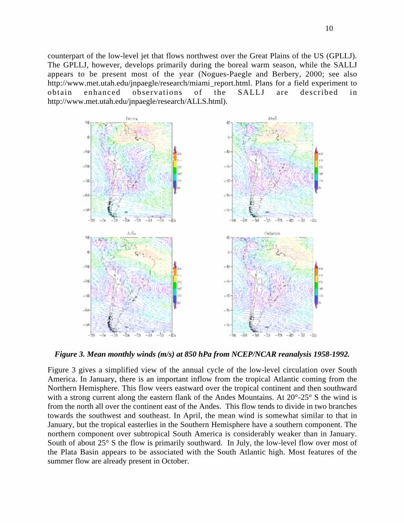
Figure 3. Mean monthly winds (m/s) at 850 hPa from NCEP/NCAR reanalysis 1958-1992.
Figure 3 gives a simplified view of the annual cycle of the low-level circulation over SouthAmerica. In January, there is an important inflow from the tropical Atlantic coming from theNorthern Hemisphere. This flow veers eastward over the tropical continent and then southwardwith a strong current along the eastern flank of the Andes Mountains. At 20°-25° S the wind isfrom the north all over the continent east of the Andes. This flow tends to divide in two branchestowards the southwest and southeast. In April, the mean wind is somewhat similar to that inJanuary, but the tropical easterlies in the Southern Hemisphere have a southern component. Thenorthern component over subtropical South America is considerably weaker than in January.South of about 25° S the flow is primarily southward. In July, the low-level flow over most ofthe Plata Basin appears to be associated with the South Atlantic high. Most features of thesummer flow are already present in October.
11
2.2 Moisture flux and sources
A complete understanding of the Plata Basin hydrology requires knowledge of the atmosphericcomponent of the water cycle. This is, however, very limited at the present time due primarily tothe lack of observational data since only about ten radiosondes are launched at different locationsonce a day. The small spatial scales of the SALLJ exacerbate the difficulties with the datascarcity.
Global analyses have been used to obtain preliminary descriptions of the moisture fluxes.Nogués-Paegle and Mo (1997) documented the moisture fluxes from the Tropics into Argentina,southern Brazil and northern Uruguay using NCEP/NCAR reanalyzes. Their results suggest thatwhile the moisture source of the GPLLJ is a water mass (the Gulf of Mexico), the SALLJ has acontinental moisture source.
Large discrepancies can be found, however, when attempting to compute moisture budgets onregional scales using global analyses from different operational centers (Wang and Paegle,1996). Moreover, the use of more recent reanalysis products (Higgins et al., 1996) does notreduce these discrepancies. A possible reason is the inadequate temporal resolution of thereanalysis data set, which fails to capture the diurnal cycle. (Berbery and Rasmusson, 1999) Thesampling frequency must be at least four times per day to obtain reliable estimates of theatmospheric water balance for the Mississippi sub-basins. There are indications that in the PlataBasin even 4 analyses per day may not be sufficient to resolve the complex nature of the diurnalcycle of moisture flux convergence (Berbery and Collini, 2000).
2.3 Precipitation
The annual mean total precipitation in the Plata Basin is about 1,100 mm, of which only about 20% (23,000 m3 s-1) reaches the sea as surface water. The other 80 % is evaporated and infiltratedinto the ground. It is apparent that any small percentage change in the evaporation andinfiltration rate may lead to greater percentage changes in the runoff. Consequently due tochanges in vegetation cover in most of the middle and upper Paraná, in the middle and lowerParaguay and in the upper Uruguay (see subsection 9.2) human activities in the last 50 years mayhave led to changes in runoff. Dams may also alter the evaporation, though probably at a lowerrate.
Annual mean rainfall in the Plata Basin tends to decrease both from north to south and from eastto west (Fig. 4). Corresponding amounts range from 1,800 mm in the maritime uplands alongthe Brazilian coast to 200 mm along the western boundary of the basin. Rainfall is large in theupper reaches of the Paraguay and Paraná River basins. The amplitude of the annual cycle inrainfall decreases from north to south (Fig. 5). The northern part of the basin has a well-definedannual cycle with maximum precipitation during summer (December-February). The centralregion (Northeast Argentina/Southern Brazil) has a more uniform seasonal distribution, withmaxima during spring and autumn. Since the major rivers in the basin generally run from northto south, this rainfall regime contributes to the attenuation of the seasonal cycle downstream.
Around 20°-25°S, enhanced rainfall in summer is signature of the SACZ development,especially towards the east. In winter and spring, on the other hand, enhanced rainfall is signatureof increased baroclinic activity. However, while the frequency of cyclogenesis is almost the

12
same in those two seasons (Gan and Rao, 1991), the water vapor content of the atmosphere ishigher and precipitation is larger in spring (Rao et al., 1996).
2.4 Temperature
The mean annual temperature in the basin ranges from around 15°C in the south to more than25°C in the northwest. Most locations east of the Andes less than 800 km from the ocean have amean annual temperature lower than 20°C. The higher altitudes in the eastern part of theBrazilian states of São Paulo, Paraná and Santa Catarina are substantially cooler than theirsurroundings.
In winter, monthly-mean temperatures have a clear north-south gradient. In July, for example,the mean temperature over the northwest part of the basin is more than 20°C, while that in theprovince of Buenos Aires is around 10°C cooler. In summer the gradient is more zonal reactingto the land ocean distribution. In January, the maximum mean temperatures are over 27.5°C inthe Chaco and western Argentina, while they are less than 22.5°C in the coastal areas of southernBrazil, Uruguay and the province of Buenos Aires (Hoffmann, 1975).
3. Mean Hydrology of the Basin
3.1 Sub-basins
The hydrological behavior of the main rivers draining the Plata Basin is strongly influenced bybasin topography - itself a product of geology and climate - and human activities (see Table 2).Topographic heights have strong meridional (the general direction of drainage) and zonalvariations. The eastern boundary of the basin has a mean altitude of 1000 m, although the waterdivide can be as high as 1500 m in the east and as low as 200 m in the south. The westernboundary includes the Andes Mountains, which reach altitudes between 1000 and 4000 m. Thereare, however, stretches in the northwest and southwest where altitudes reach only about 500 mand 300 m, respectively.
The Paraná River originates at the confluence of the Paranaiba and Grande Rivers in southeastBrazil (Fig. 1), and stretches of the river mark the boundary between Paraguay and Brazil, andParaguay and Argentina. The Paraná flows mainly through the plains of Paraguay and Argentinabefore joining the Uruguay River at the head of the Plata River. The Paraná's main tributary isthe Paraguay River, which originates in central Brazil. The poor natural drainage of the regionthrough which the Paraguay flows has created the Pantanal, one of the world's largest wetlandswith an area that can be as large as 140,000 km2 (Fig. 1). The Pantanal's slope is 0.25 m km-1 inthe east-west direction but only 0.01 m km- 1 in the North-South direction. Such a very shallowslope produces a time lag in the flood peak between the north and south of the Pantanal of aboutfour months.

13
Figure 4. Annual-mean precipitation in the Plata Basin from Xie&Arkin.

14
Figure 5. Monthly-mean precipitation in the Plata Basin from (Xie and Arkin, 1997).

15
Table 2 Selected characteristics of the three principal sub-basins.
Main River Distance from upstream
(km2)
Basinarea
(103km2)
Annual-meanflow
(m3 s –1)
Paraná River
Junction of Paranaiba
and Grande
1,200 (Paranaiba),
1,000 (Grande)
376 4,370
Junction with Paraguay 2,540 975 11,800
Mouth 3,780 1,510 17,700
Paraguay River
At Cáceres 420 33.8 345
Final section 2,620 1,095 2,700
Uruguay River 1,600 365 5,500
The flow regime in the Paraguay River as a whole is strongly influenced by the Pantanal storage,one consequence being that annual peak water levels in the Upper Paraguay are correlatedbetween one year and the next, regardless of rainfall conditions. Between the Pantanal andCorrientes in Argentina, where the Paraguay joins the Paraná, the mean slope is about 0.04 mkm-1.
The Uruguay River starts in the Serra do Mar and defines the boundary between the states ofSanta Catarina and Rio Grande do Sul in Brazil. From there on it marks the boundary betweenArgentina and Brazil until its convergence with the Cuareim River, where it becomes theboundary between Argentina and Uruguay. The major tributary of the Uruguay River is theNegro River, which originates in Brazil and crosses Uruguay from the northeast to the west. TheNegro’s total length and the area of its basin are about 850 km and 71,200 km2, respectively.
3.2 Hydrological regions
The Plata Basin is a combination of several regions with different hydrological characteristics. Inthe upper Paraná and Paraguay Basins, the rainy season occurs during summer. In the UruguayBasin, on the other hand, high-flow season occurs during winter. Based on hydrologicalcharacteristics, the Plata Basin can be divided into six regions:
Upper Paraná. This region extends from the origins of the catchment to the confluence with theIguazú River. The upper part has suffered significant change in soil cover characteristics, whichhas gone from 90% coverage to approximately 5% coverage in 50 years in some parts (Tucci etal., 1999).
16
Upper Paraguay. This region extends from the origins to the Apa River, on the border betweenParaguay and Brazil, below El Pantanal.
Bermejo and Pilcomayo Rivers. The basins of these rivers are the largest producers ofsediments.
Uruguay. This is a basin with significant changes in soil cover characteristics.
Middle and Lower Paraná and Paraguay. This region is characterized by wide floodplains,which remain flooded for long periods during large flood events but which make a smallcontribution to the total river discharge.
La Plata River. This is a shallow-water system significantly influenced by meteorological andastronomical tides. It may be separated into upper and lower parts.
As is to be expected in an area as large as the Plata Basin, the principal matters of hydrologicalconcern vary considerably between sub-basin and from upper to lower reaches. In the UpperParaná River, above the confluence with the Iguazú River, the principal factor is the use andoperation of the huge hydropower production, and the change in land use from natural forest toarable cropping systems based on soybean production. In the lower courses of the Paraguay andParaná Rivers, the principal matters of hydrological concern are navigation, and flood control. Inthe recent past, floods on those rivers have caused significant loss of life and damage to property.
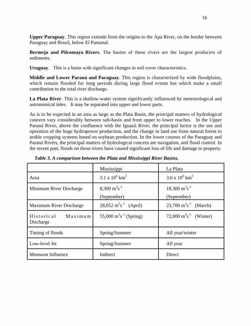
Table 3. A comparison between the Plata and Mississippi River Basins.
Mississippi La Plata
Area 3.1 x 10⁶ km2 3.6 x 10⁶ km2
Minimum River Discharge 8,300 m3s-1
(September)
18,300 m3s-1
(September)
Maximum River Discharge 28,052 m3s-1 (April) 23,700 m3s-1 (March)
H i s t o r i c a l M a x i m u mDischarge
55,000 m3s-1 (Spring) 72,000 m3s-1 (Winter)
Timing of floods Spring/Summer All year/winter
Low-level Jet Spring/Summer All year
Monsoon Influence Indirect Direct

17
Figure 6. Satellite view of flooded areas during January 1998.
3.3 Temporal and spatial variability of hydrological conditions
The variability in soil moisture, soil cover and soil use can have important impacts on the watercycle. The flooded area of the Pantanal can increase from 10,000 km2 during dry periods tomore than 140,000 km2 during flood periods with potential implications for atmosphere-landsurface feedbacks. Another area of strong variability is on the Middle and Lower Paraná, whichmay have large areas flooded during several months in big floods (Fig. 6).
4. Variability of the Basin’s Climate
4.1 Mesoscale variability and the diurnal cycle
The atmospheric water cycle of the Plata Basin is significantly influenced by mesoscalevariabilities asociated with the SALLJ (Wang and Paegle, 1996; Berbery and Collini, 2000). TheSALLJ has a diurnal cycle with a nighttime maximum that favors increased moisture fluxconvergence in the Plata Basin. This convergence, in turn, is associated with generalizednighttime ascent and precipitation. A second precipitation regime is found toward the easternpart of the basin, where largest values during daytime appear to be associated with a
18
convectively unstable atmosphere, with convection being triggered by a sea breeze enhanced bythe topography of southern Brazil.
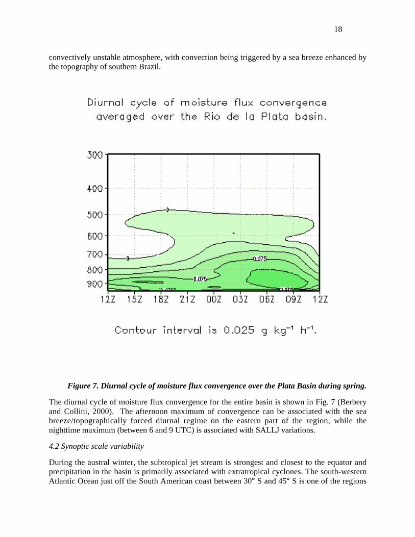
Figure 7. Diurnal cycle of moisture flux convergence over the Plata Basin during spring.
The diurnal cycle of moisture flux convergence for the entire basin is shown in Fig. 7 (Berberyand Collini, 2000). The afternoon maximum of convergence can be associated with the seabreeze/topographically forced diurnal regime on the eastern part of the region, while thenighttime maximum (between 6 and 9 UTC) is associated with SALLJ variations.
4.2 Synoptic scale variability
During the austral winter, the subtropical jet stream is strongest and closest to the equator andprecipitation in the basin is primarily associated with extratropical cyclones. The south-westernAtlantic Ocean just off the South American coast between 30° S and 45° S is one of the regions
19
with the highest cyclogenetic activity in the Southern Hemisphere. Eastward traveling cyclonicsystems that develop over the ocean can intensify after reaching the continent and followtrajectories along the coast. Sea surface temperature (SST) gradients can have a significantinfluence on the trajectories of these cyclones and their associated sensible and latent surfaceheat fluxes (Saraiva and Silva Dias, 1997). Frontal systems move rapidly over land regions oflow specific humidity and high loss of heat by radiation, and are not generally associated withstrong convective activity. Cold surges, known as "friagens" can reach as north as central andsouthern Brazil (Parameter, 1976; Hamilton and Tarifa, 1978; Fortune and Kousky, 1983;Marengo et al., 1998) and have large economic consequences.
Synoptic scales waves move across the basin. For cyclonic disturbances, the low-levelperturbation intensifies at around 1,000 km east of the Andes mountains. Rainfall accumulatedover cyclonic episodes amounts to more than 60% of the mean winter accumulated precipitationover central Argentina. This precipitation is associated with an increased contribution ofmoisture from the tropics along the eastern flank of the Andes Mountains, and positiveanomalies of the atmospheric column water content (Vera et al., 2001).
4.3 Intraseasonal variability
Variability of the SACZ is of primary importance for precipitation variability in the Plata Basinduring summer. Anomalies in rainfall over the SACZ tend to be out-of-phase with anomaliesover adjacent regions to the south (e.g., Nogués-Paegle and Mo, 1997; Aceituno and Montecinos,1997). Several studies agree that convection variability over South America is characterized by adipole-type pattern with centers over the SACZ and the subtropical plains. Namely, when theSACZ is enhanced and associated precipitation/upward motion increase then subsidenceincreases and precipitation decreases to the south. Conversely, when the SACZ is weakened andassociated precipitation/upward motion decrease, subsidence decreases and precipitationincreases to the south. Such dipole-type variability is modulated by modes with different timescales.
It has been suggested that the Madden-Julian Oscillation (MJO) propagating along the tropicsmodulates the northward component of the dipole associated with SACZ variability (Nogués-Paegle and Mo, 1997). The southern component of the SACZ dipole is modulated by a higherfrequency (22-28 day) mode that extends from the central Pacific eastward and southward frommid-latitudes before curving northeast towards South America. Convection variability in theSPCZ has been linked to that in the SACZ through southeastwardly propagating waves thatcurve toward the northeast over South America (Kiladis and Weickmann, 1992; Grimm andSilva-Dias, 1995; Liebmann et al., 1999).
4.4 Interannual variability
Several studies have found links between ENSO events in the equatorial Pacific Ocean andrainfall anomalies during late austral spring-early summer and late austral fall-early winter inextratropical South America. Here, there are significant negative correlations between rainfalland the Southern Oscillation Index (SOI) during October-November (Aceituno, 1988). Rainfallanomalies in northeastern Argentina, southeastern Brazil and Uruguay tend to be positive fromNovember of El Niño years to February of the following years and negative from July toDecember of La Niña years (Ropelewski and Halpert, 1987,1989). In the same area but also in

20
Paraguay there is a positive and significant difference in spring precipitation between El Niñoand La Niña (Kiladis and Diaz, 1989).
There are also detailed studies on the interannual response of the precipitation to the warm andcold phases of ENSO in some regions of the Plata Basin. Precipitation correlates significantlywith ENSO indexes during the austral spring in the south of Brazil (Rao and Hada, 1990; Grimmet al., 1998) with similar signals during the winter. In Uruguay and southern Brazil rainfall tendsto be higher than average in El Niño years, especially during November-January, and lower thanaverage in years with a high index phase of the Southern Oscillation (HSOI years), especially inOctober-December (Pisciottano et al., 1994). In addition, rainfall anomalies tend to switch signsduring January and February (late austral summer) after HSOI years, but not after El Niño years.These precipitation anomalies during ENSO events are associated with atmospheric circulationanomalies. Over most of southeastern South America in spring during warm (cold) ENSOevents, the subtropical jet and cyclonic activity are enhanced (weakened). During most of thewarm (cold) ENSO events, the Chaco low deepends (weakens) and the moisture advection fromthe north increases (Grimm et al., 2000).
The leading empirical orthogonal function (EOF) mode of both wind components in the uppertroposphere over South America during summer from the NCEP reanalysis consists of a strong,anomalous, large-scale eddy circulation over the SACZ (Robertson and Mechoso, 2000). Ananomalous cyclonic (anticyclonic) eddy was found to accompany an intensified (diffuse) SACZ,with anomalous descent (ascent) to the southwest. At low levels, an intensified (weakened)SACZ was found to be associated with a weak (strong) flows east of the Andes.
Interannual variability in the January-March period appears to be largely uncorrelated withENSO, while it exhibits strong correlations with SSTs over the south west Atlantic (Robertsonand Mechoso, 2000). However, similar SACZ circulation patterns also occur during theOctober–November period, at which time they are strongly teleconnected with ENSO (G. Cazes,A. W. Robertson and C. R. Mechoso, pers. comm. 2000). This marked seasonality in ENSOteleconnections is consistent with the findings of Pisciottano et al. (1994) who found thestrongest ENSO influence on Uruguay rainfall to be in the spring. During the austral spring of ElNiño years, the SACZ is weakened accompanied by enhanced ascent to the southwest and anintensified southward flow east of the Andes, consistent with positive rainfall anomalies overUruguay.
During summer, increased (reduced) precipitation in southern Brazil, most of Uruguay andnortheastern Argentina are likely to be associated with a weaker (stronger) SACZ, and withincreased (reduced) rainfall further south in Argentina (Barros et al., 2000a). Barros et al., 2000have also found meridional displacements of the SACZ to be important for precipitation, and thatwarm (cold) SST anomalies over the southwestern Atlantic (20°S - 40°S, west of 30°W) arelikely to be accompanied by a southward (northward) shift of the SACZ. The precipitation fieldin southeastern South America is also affected in other seasons by SST anomalies in theneighboring Atlantic Ocean (Diaz et al., 1998; Barros et al 2000a).
4.5 Decadal variability and trends
21
Rainfall variability in most of southern South America has important interdecadal components.The strongest interdecadal variability in the annual cycle of precipitation occurs in regions oftransition between precipitation regimes, especially in the Paraná River Basin (Rusticucci andPeñalba, 1997). In subtropical Argentina the annual precipitation also shows oscillations withperiods from 7 to 10 years (Peñalba and Vargas, 1993; Minetti et al., 1982; Minetti and Vargas,1983). On this time scale there is a close relationship between the temperature and precipitationregimes (Rusticucci and Peñalba, 1997). Precipitation trends in Argentina have been positivesince 1916 and even increased after the late fifties (Castañeda and Barros, 1994). This behavioris consistent with a climatic jump around the 1960's, when the southern portion of SouthAmerica experienced a significant warming (Vargas et al., 1995). Precipitation increased by upto 30% between 1956 and 1991 in several localities between 20° S and 35° S east of the Andes(Castañeda and Barros, 1994). In a large part of this region, most of the increase occurred duringthe 1960's, and it seems to have been associated with a reduction of the meridional gradient ofsurface temperature, which probably caused a southward shift of the regional circulation.Consistently, the leading principal component of annual precipitation correlates with themeridional gradient of temperature at interannual as well as interdecadal timescales (Barros andDoyle, 1996). Another strong precipitation increase was observed during late 1970s. Thiscorrelates with an increase in the subtropical temperature of the Southern Hemisphere and adecrease of the SOI (Barros and Doyle, 1996). The positive trend in precipitation during 1956-1991 has facilitated a southward extension of the agricultural frontier in Argentina increasingavailable lands by the 1960s in an amount that exceeds 100,000 km2 (Barros et al, 2000b).
Trends in precipitation over the basin prior to the 1960s have also been detected. A linear trendhas been reported in the monthly and annual rainfall in part of the province of Buenos Aires(Peñalba and Vargas, 1996). Decreased precipitation in subtropical Argentina tends to beassociated with enhanced westerly flow in Patagonia (Schwerdtfeger and Vasino, 1954). Thenegative trend in the subtropical region in the period 1931-50 could be associated with a slowingof the westerlies over Patagonia. Significant negative correlations have been obtained betweenthe westerly flow and rainfall in eastern Argentina (Díaz, 1959).
It has been suggested that when the zonal circulation is strong in the tropical Atlantic, the Hadleycell is weaker over the South American sector, which leads to a poleward displacement of thesubtropical highs and to larger rainfall in the subtropical region (Pittock, 1980). These featuresare consistent with the notion that in a large region of subtropical South America east of theAndes, the periods of time in which systems are displaced anomalously far south tend to beassociated with larger than average rainfall. The opposite occurs when the systems are displacedanomalously north. A near-cyclic 15-year component has been found in the leading mode ofSACZ circulation anomalies (Robertson and Mechoso, 2000). This periodicity was corroboratedfrom independent analyses of southwest Atlantic SSTs and river flows (see section 5.1).
5. Variability of the Basin’s Hydrology
22
5.1 River flow
Several studies have addressed the variability of river streamflow in the Plata Basin (e.g.Aceituno, 1988; Mechoso and Perez-Iribarren, 1992; Marengo, 1995; García and Vargas, 1998;Genta et al., 1998; García, 1999; Bischoff et al. 2000; Camilloni and Barros, 2000). The annualstreamflow of the Negro, Paraguay, Paraná, and Uruguay Rivers during the period 1911-93includes a nonlinear trend and a near-decadal component (Genta et al., 1998; Robertson andMechoso, 1998). On the decadal time scale, high river runoff is associated with anomalouslycool SSTs over the tropical North Atlantic, with the strong signal in the Paraguay and ParanáRivers during summer. Interannual streamflow peaks with ENSO time scales were only found tobe significant in the Negro and Uruguay Rivers in the southeast. Here, El Niño is associated withenhanced streamflow.
The interannual-to-decadal variability of the SACZ has an interdecadal 15-year component thatis also present in river flow (Robertson and Mechoso, 2000). When the SACZ is intensified, theParaná River in southern Brazil tend to swell while the Uruguay and Negro Rivers to the southtend to ebb. The interdecadal component was found to be much stronger in the north-southgradient of streamflow anomalies than in the streamflows themselves. The Paraná River isdirectly influenced by the SACZ. The Uruguay-Negro Rivers to the south are influenced in theopposite sense through the dipole in vertical motion, and possibly by accompanying variations insouthward moisture transport by the SALLJ.
A 14–16-year interdecadal component in broad-scale SSTs and sea-level pressures over theSouth Atlantic has been documented by Venegas et al. (1998). A strengthening (weakening) ofthe subtropical anticyclone over the South Atlantic is found to accompany negative (positive)broad-scale underlying SST anomalies. This mode bears spatial and temporal similarities to thatfound by Robertson and Mechoso (2000), so that the latter may be the regional counterpart ofbasin-scale South Atlantic variability.
There is evidence of changes in the annual runoff cycle before and after 1983 (Camilloni andBarros, 2000). The maximum discharge changes from February (before 1880) to autumn (after1983) in Corrientes and Posadas, together with an important increment in the mean annualdischarge. These changes may be due to climate variability, river regulation by dams and/orrunoff change because of changes in soil use. The climate signal is consistent with an increasingtrend in the precipitation over the upper and middle Paraná basin during the fall season(Camilloni and Castañeda, 2000). River regulation by dams is a direct consequence of the annualcycle of precipitation and the overriding share of hydropower offer in the Brazilian energymatrix, which requires to save part of the waters for autumn and winter use.
5.2 Flood and drought
Flooding is of major concern in the Plata Basin. Most rivers have long and wide flood plains,which have been settled and cultivated. Over a considerable period of time (1950-73), annualfloods were not extensive. This encouraged the belief that settlements could be built in locationsthat were subsequently shown to be at severe risk of flooding. The largest flood of the centuryoccurred on the Paraná River in 1983 during a strong ENSO event. For a year and a half after theevent, the Paraná flood level was above street level in parts of Santa Fé, Argentina (Tucci and

23
Clarke, 1998). In União da Vitória on the Iguazú River, the cost of the flood amounted toUS$78 million. In the state of Santa Catarina the damages represented 8% of that state's grossproduct for the year. Losses for floods in Argentina during the 1983 and 1992 episodes exceededUS$1 billion each.
The four greatest peak discharges in the middle Paraná on record occurred during May to July,following the El Niño years of 1983, 1904, 1992 and 1998, when there were strong and positiveSST anomalies in the Niño-3 region. Also, whenever SST in Niño-3 remains warmer duringthose months, there are large discharges on the middle Paraná, with a magnitude directlyproportional to that of the of SST anomalies. In addition, for every El Niño event since 1976,SST anomalies in Niño-3 have been positive during the austral autumn of the following year,which suggests a phase change in the EN events. In this context, the probability of other eventsimilar to 1983 is higher than what could be inferred from a simple recurrence analysis of the100year record (Camilloni and Barros, 2000).
6. Selected Relevant Studies with Numerical Models
6.1 Atmospheric General Circulation Models (AGCMs)
Atmospheric general circulation models (AGCMs) refer to numerical models that simulate theevolution, maintenance and variations of the general circulation of the atmosphere. Acomprehensive numerical model of the atmosphere can be used either as a AGCM or as anextended numerical weather prediction (NWP) model. The dependence of the solution on initialconditions is usually not emphasized in AGCM applications, as in climate simulations or climatepredictions of the second kind, while it is crucially important in NWP applications, or climatepredictions of the first kind.
AGCMs have been used to estimate regional moisture budgets. According to the moisturebudgets by an AGCM in different regions of South America, by Lenters and Cook (1997),suggest that precipitation in the central Andes is primarily associated with orographic effects andlarge scale wind convergence. Over the SACZ, in contrast, evaporation, wind convergence andmoisture advection make positive contributions to the balance, while orographic influences makea negative contribution and transients have a minimum impact. The AGCM simulations,however, do not capture the precipitation maximum in southern Brazil/northeastern Argentina,which corresponds to the SALLJ exit region. Experiments with and without orographicelevations using the same AGCM confirmed the important role played by the Andes inorganizing the low-level convergence and precipitation in the region (Tanajura, 1996; Lentersand Cook, 1999).
6.2 Mesoscale models
It is apparent that simulations by AGCMs with relatively low-resolution cannot capture cruciallocal aspects of moisture fluxes and their convergence. This has motivated the use of ensemblesof short-range forecasts performed with regional models to estimate moisture budgets in riverbasins. The consensus view is that such a procedure is the only one that can currently producereliable results (Berbery and Rasmusson, 1999). The National Centers for EnvironmentalPrediction (NCEP) Eta model (Mesinger et al., 1988) appears to be well suited to represent thesharp slopes of major mountain ranges. Even for a horizontal resolution of 80 km, the eta-model
24
topography (with heights up to 5100 m) captures the massive block of the Andes mountains andthe sharp slopes that in some regions become practically vertical walls. Other features, such asthe Altiplano, the Brazilian Plateau, and the even smaller Guiana Highlands are also wellcaptured.
The role of different processes participating in the moisture budget of the Plata Basin has beeninvestigated by performing a series of forecasts using the Eta model with NCEP/NCARreanalyses as initial and boundary conditions. (Berbery et al., 1996; Berbery and Collini, 2000). For the southern summer, the model successfully simulated the precipitation maxima over theSACZ, northeastern Argentina/Paraguay/southern Brazil, and southern Chile (see Fig. 8). Theimportance of the SALLJ in transporting moisture to higher latitudes is apparent in the upperpanel of Fig. 9, which depicts the vertically integrated moisture flux as calculated in the model'scomputational grid. The exit region of the low-level jet coincides with a large area of moistureflux convergence collocated with the maximum in precipitation. Consistent with water balanceconcepts, the results suggest that moisture flux convergence related to the low-level jet is a keycomponent in the processes that generate precipitation over northern Argentina, southern Brazil,and northern Uruguay (lower panel of Fig. 9).
6.3 Hydrological models
Hydrological models of river basins can be broadly divided into two types: (a) deterministic, and(b) statistical. Deterministic models seek to describe the relation between precipitation,evaporation and river-flow in physical terms. The river basin may be regarded as a single entitytransforming mean precipitation, over the entire basin area, into runoff (a lumped model), or as aset of separate but inter-connected sub-basins which function in series or in parallel (a distributedmodel). In either case, the model consists of a set of hypothetical reservoirs with rules - oftencontaining empirical constants – which determine how water is transferred between them and/orback to the atmosphere as evaporation losses. Water leaving the reservoirs may be routed alongriver channels to the exit point of the river basin; this routing procedure may involve empiricalconstants to give the appropriate delay before the output from a reservoir arrives at the basinoutfall, or it may use simplified forms of the energy conservation equation. A deterministicmodel of any type contains parameters which must be estimated . Some parameters can berelated to physically measurable quantitites, like soil depths. Others must be fitted by minimizingsome measure of difference between modeled streamflow and observed streamflow, eitherheuristically or via formalized optimization procedures. Deterministic models are useful formaking short-term predictions of river behavior (for example, flood routing) and also for givingqualitative estimates of how flow characteristics may change as a result of changes in soil cover.The latter application is limited by the fact that empirical constants fitted by optimization arethose giving best fit to the observed (historic) record, and may not be appropriate whereconditions of climate or soil cover have changed.

25
Figure 8. Eta model forecast precipitation and three observed estimates.

26
Figure 9. Vertical-mean moisture flux and its convergence simulated by the ETA model.
27
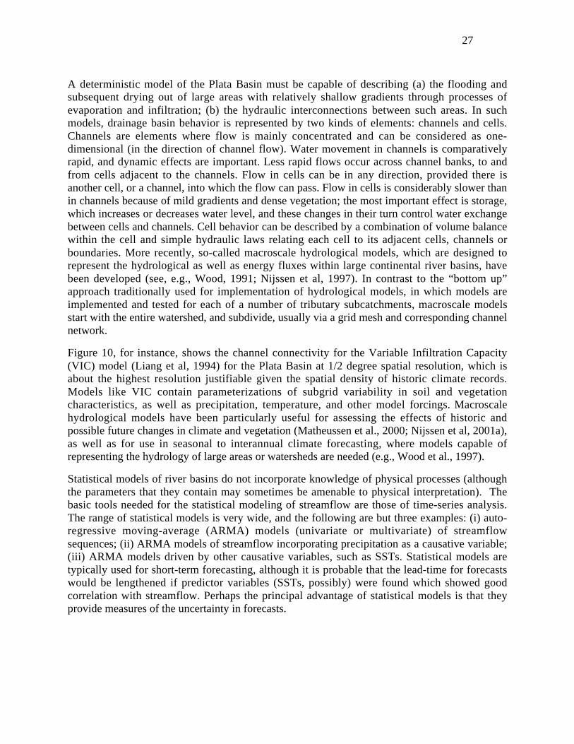
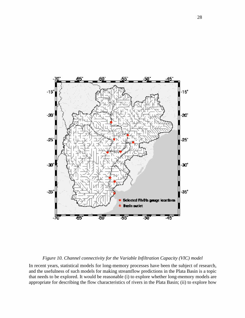
A deterministic model of the Plata Basin must be capable of describing (a) the flooding andsubsequent drying out of large areas with relatively shallow gradients through processes ofevaporation and infiltration; (b) the hydraulic interconnections between such areas. In suchmodels, drainage basin behavior is represented by two kinds of elements: channels and cells.Channels are elements where flow is mainly concentrated and can be considered as one-dimensional (in the direction of channel flow). Water movement in channels is comparativelyrapid, and dynamic effects are important. Less rapid flows occur across channel banks, to andfrom cells adjacent to the channels. Flow in cells can be in any direction, provided there isanother cell, or a channel, into which the flow can pass. Flow in cells is considerably slower thanin channels because of mild gradients and dense vegetation; the most important effect is storage,which increases or decreases water level, and these changes in their turn control water exchangebetween cells and channels. Cell behavior can be described by a combination of volume balancewithin the cell and simple hydraulic laws relating each cell to its adjacent cells, channels orboundaries. More recently, so-called macroscale hydrological models, which are designed torepresent the hydrological as well as energy fluxes within large continental river basins, havebeen developed (see, e.g., Wood, 1991; Nijssen et al, 1997). In contrast to the “bottom up”approach traditionally used for implementation of hydrological models, in which models areimplemented and tested for each of a number of tributary subcatchments, macroscale modelsstart with the entire watershed, and subdivide, usually via a grid mesh and corresponding channelnetwork.
Figure 10, for instance, shows the channel connectivity for the Variable Infiltration Capacity(VIC) model (Liang et al, 1994) for the Plata Basin at 1/2 degree spatial resolution, which isabout the highest resolution justifiable given the spatial density of historic climate records.Models like VIC contain parameterizations of subgrid variability in soil and vegetationcharacteristics, as well as precipitation, temperature, and other model forcings. Macroscalehydrological models have been particularly useful for assessing the effects of historic andpossible future changes in climate and vegetation (Matheussen et al., 2000; Nijssen et al, 2001a),as well as for use in seasonal to interannual climate forecasting, where models capable ofrepresenting the hydrology of large areas or watersheds are needed (e.g., Wood et al., 1997).
Statistical models of river basins do not incorporate knowledge of physical processes (althoughthe parameters that they contain may sometimes be amenable to physical interpretation). Thebasic tools needed for the statistical modeling of streamflow are those of time-series analysis.The range of statistical models is very wide, and the following are but three examples: (i) auto-regressive moving-average (ARMA) models (univariate or multivariate) of streamflowsequences; (ii) ARMA models of streamflow incorporating precipitation as a causative variable;(iii) ARMA models driven by other causative variables, such as SSTs. Statistical models aretypically used for short-term forecasting, although it is probable that the lead-time for forecastswould be lengthened if predictor variables (SSTs, possibly) were found which showed goodcorrelation with streamflow. Perhaps the principal advantage of statistical models is that theyprovide measures of the uncertainty in forecasts.
28
Figure 10. Channel connectivity for the Variable Infiltration Capacity (VIC) model
In recent years, statistical models for long-memory processes have been the subject of research,and the usefulness of such models for making streamflow predictions in the Plata Basin is a topicthat needs to be explored. It would be reasonable (i) to explore whether long-memory models areappropriate for describing the flow characteristics of rivers in the Plata Basin; (ii) to explore how

29
predictions given by such models compare with predictions given by models having a soundphysical basis. A further point to be considered is that such models can provide measures of theuncertainty in predictions that result from their use. An important limitation of statistical modelsis that they require relatively long time series for estimation of parameters, and therefore mayhave difficulty representing the effects of changing climate.
6.4 Watershed models
Watershed models simulate the transformation of a series of daily rainfall inputs to the resultingstreamflow hydrograph at the basin outlet. Due to the large area of the catchment rainfall-runoffmodeling for the entire Plata Basin and its main sub-basins (Paraná, Paraguay, Uruguay,Bermejo and Pilcomayo) has only recently been attempted (Nijssen et al., 2001b). As part of astudy of global rivers, Nijssen et al applied the VIC model to the Plata Basin at the very coarsespatial resolution of 2° longitude x 2° latitude, using the Global Precipitation Data Project(GPCP) and other global data sources as forcings, for the period 1979-93.
Figure 11. Mean monthly observed and simulated discharge (in m3 s-1) for the Parana River atCorrientes (Simulation period 1980-1993)
Figure 11 shows that although the annual mean runoff was reasonably well simulated, the modelgreatly overestimated the magnitude of the seasonal cycle of streamflow. The likely reason is the
30
absence of a mechanism in the VIC model to represent the effects of surface storage in seasonalflood plains. A more recent version of the model includes explicit representation of the effectsof storage in lakes and wetlands, and may resolve this problem. Another major obstacle torainfall-runoff modeling in the Plata Basin is the lack of readily accessible historical rainfall datafor the basin. Although much of this problem is traceable to the absence of long-term networks,some data are potentially available that have yet to be archived electronically, a problem thatPlatin may be able to resolve. In any event, most attempts at rainfall-runoff modeling have beenconfined to the smaller sub-basins, and large scale efforts have focused more on dynamic routingin the channel (see subsection 6.5).
Among the efforts at hydrological modeling at the sub-basin scale are application of the Hidro-Urfing model to the Laguna I and the Pereira Basins, two sub-basins of the Negro Rivercatchment with a surface area of 13,945 km2 and 11,354 km2, respectively. Hidro-Urfing is alumped conceptual-hydrological model based on the operational Sacramento catchment modeldeveloped by the U.S. National Weather Service and the California Department of WaterResources (Burnash et al. 1973, 1995) and the HBV model developed by the SwedishMeteorological and Hydrological Institute (Bergström 1976,1995). The model can be applied tolarge basins with small to gently undulating slopes. Daily rainfall and monthly-mean values ofpotential evapotranspiration are prescribed based on observational data. Calibration performedusing precipitation and streamflow from observational data showed an acceptable agreementbetween computed and observed hydrographs for the major storms, both for the rising and thelimbs (Genta et al. 1992; Silveira 1998, 2000). Other studies have been reported for tributaries ofthe Uruguay, Tietê and Iguazú Rivers, and for the Paraguay River and one of its tributaries(Tucci, 1991; Tucci and Damiani, 1994; Damiani, 1991).
IPH2 is a rainfall-runoff model developed at the Instituto de Pesquisas Hidráulicas (IPH). Likeall hydrological models, its basis is the continuity equation. It works by regarding a drainagebasin as a series of storage tanks, with rainfall entering at the top, and being split between what ispassed back to the atmosphere as evaporation, and what emerges from the basin as runoff(streamflow). Depending on the number of tanks, and the number of parameters controlling thepassage of water between them, the model can be made more complex or less so.The IPH2Model was used to analyze the effects of climate change on the water resources of some UruguayRiver tributaries. There have also been studies of the use of rainfall-runoff models on the IguazúRiver to explore the effects of proposed hydro-electric schemes in a metropolitan region whereurban growth is very rapid. The IPH2 Model was also used (Tucci, 1998) to study rainfall-runoffrelationships for a set of tributaries of the Iguazú River near to Foz de Areia, the first largereservoir of the hydroelectric generating system on this river. The same model, together with ahydrodynamical model of channel flow, was used in a flood analysis of the metropolitan regionof Curitiba, the capital of the Brazilian State of Paraná (Tucci, 1996).
TOPMODEL is a hydrological model that builds in aspects of basin topography (Beven andKirkby, 1979). The use of TOPMODEL in a 59 km2 basin of the Corumbataí River, whichforms part of Tietê drainage basin draining to the Paraná River, was explored by Schuler et al.(2000). The authors concluded that the model showed good promise for future applications whenadapted to local conditions.
The Water and Environment Institute of Argentina (INA) has applied watershed models to thelower part of the Iguazú basin. They obtained daily river flows by using the U.S. National
31
Weather Service River Forecast System (NWSRFS). This is a lumped input-output parametermodel, which is the main tool for streamflow forecast in the US.
6.5 Hydrodynamical models
There are operative hydrodynamical models covering the major rivers of the Plata Basin: Plataitself, Paraná, and Uruguay.
From the hydrodynamical point of view the Plata River behaves as an estuary since watercurrents are basically controlled by the oceanic tides penetrating through its mouth. Though thetides amplitude is small (about 0,60 m between low and high tide), the very large river width(minimum 40 km) allows for a tidal prism important enough to dominate the flow regime despitethe huge discharge received from the tributaries (average 22,000 m3 s-1). The base flow generatedby this discharge is strong enough to avoid saline water penetration in the inner river, extendingfrom its head to the upstream of the imaginary line Punta Piedras (Argentina) – Montevideo(Uruguay). The Plata's denomination as a river, instead of as an estuary, arises precisely fromthis freshwater character. The saline stratification can be detected in the outer region, thoughcomplete vertical mixing can occur for strong wind conditions.
The Plata River has been modeled as a shallow water body. Shallow-water models are goodenough for engineering applications, mainly to provide boundary conditions for nested, localhydrodynamical models to be used in coastal engineering studies. At the present time, groups inArgentina, Uruguay and Brazil have development efforts on three-dimensional hydrodynamicalmodels for the estuary and adjacent shelf waters.
The Plata River dynamics and its environment are strongly affected by the variability of itstributary rivers. Salinity structure and distribution and accompanying processes, likesedimentation and ecosystem metabolism, are modulated in such a way that provokes, amongother effects, changes in mean sea level mainly in the northern coast. Fisheries in the area, whichare a significant economic resource, are affected due to the sensitivity of commercial species tochanges in the position of the saline front in the river which controls the spawning and fishrecruitment.
Efforts to model the Paraná River have focused primarily in flood routing problems. One-dimensional models of different stretches of the river have been developed since the seventies forhydraulic engineering studies (Jaime and Menéndez, 1997). In addition, a model of the ParanáRiver Delta has been developed and is used in operational mode (Fontana, 1995).
The major concern with the Uruguay River in Argentina and Uruguay is flood routing. Therehave been several attempts to model the river with one-dimensional hydrodynamical models.The Comisión Técnica Mixta (CTM) in charge of the Salto Grande dam, has been operating ahydrodynamical model within an integrated monitoring/hydrological/hydrodynamical modelsystem that assists in water management decisions. The model developed by DPHER for theParaná Delta also includes the Uruguay River's stretch from the Salto Grande dam down to therivers discharge in the Plata River. CARU (the bi-national commission that manages theUruguay River) has another hydrodynamical model (based on MIKE 11) that is being operatedby INA and DNH (Uruguay).

32
Flood behavior in the Paraguay River, particularly in areas subject to frequent seasonal floodinghas been studied by Mascarenhas and Miguez (1994) using a hydrodynamical model, coupledwith a cell model, to study; the authors used their model to describe the formation and passagedownstream of floods originating within the Pantanal. In the Planalto region adjacent to thePantanal, Colischonn et al. (2001) applied a distributed rainfall-runoff model, specificallydeveloped for modeling large basins. The model was used on the basin of the Taquari River, atributary of the Paraguay that joins it in the Pantanal. Its drainage area above this point isapproximately 28 000 km2. The distributed model has regular square cells of 100 km2 which aresub-divided into blocks according to soil use and vegetation cover. Despite the limited rainfallrecords available, it was possible to model a flow sequence with reasonable precision, notablyfor monthly time intervals.
7. Predictability
7.1 Climate and weather prediction
Past experience in weather and seasonal climate prediction based on the Center for Ocean-Land-Atmosphere (COLA) model at CPTEC, Brazil, suggests that the regions with highestpredictability in South America east of the Andes are northern Amazonia-Northeast Brazil andthe extreme southern Brazil-northern Argentina. Central-southeast Brazil (where most of theParaná Basin is located) predictability is relatively low. Here the transition between regimes ofconvection in Amazonia and the SACZ makes the ENSO signal less clear than in northeastBrazil. For this reason, local correlations between rainfall tend to be low. In addition, it isdifficult to define a "peak of the rainy season" in this season. Similar results have been obtainedwith the CCM3, the ECHAM and NCEP models.
7.2 Hydrology
The predictability of hydrological parameters has also been studies using statistical techniques.A system for hydrometeorological forecasts in the seasonal-to-interannual range was developedby Liu et al. (1997) and Valdés et al. (1999). The key features of this system are: 1) multipleENSO forecasts are integrated into one forecast, 2) each ENSO forecast is weighted according toits error covariance structure as a function of lead-time, and 3) both ENSO and seasonalhydrological forecasts are used to update the underlying persistence (markovian) stochasticprocess.
The system, which produced promising results for the stremflow anomalies of the Nare andGrande Rivers in Colombia, was applied to seasonal forecasts of the Paraná River at Corrientes(Valdés et al., 1999). Preliminary results show a weak negative correlation between runoff andthe SOI (Aceituno, 1988). This relationship, furthermore, is clearer during low SOI episodes(García and Vargas, 1998; García, 1999). A sample of the results is given in Table 4. Valdés etal. (1999) also found a clear seasonality of forecasting skills. Similar results were obtained forthe streamflows of the Paraná at Posadas and the Paraguay at Puerto Bermejo.

33
Table 4 RMSE (root-mean-square-error) reductions (in parenthesis) of seasonal streamflowsfor the Paraná River
Season
Model
January -March
A p r i l -June
J u l y -September
October -December
Climatology 5540.9 6768.19 5294.96 4940.44
Persistence 5413.5(2%)
6464.96(4.5%)
4160.42(21%)
4307.00(13%)
E N S O +Persistence
4576.60(17%)
5800.52(14%)
3905.17(26%)
4024.82(19%)
Interannual-to-decadal predictability of the Paraná River has been investigated by Robertson etal. (2001), based upon extracting near-cyclic components in summer-season streamflows atCorrientes over the period 1904-1997. These variations explain about 15% of the variance eachfor the near 9-year and 15-17 year cycles, compared to about 25% for ENSO. It was found thatoscillatory components with periods of about 2-5, 8 and 17 years are accompanied bystatistically significant changes in monthly streamflow. Autoregressive predictive models werethen constructed for each component (Keppenne and Ghil, 1992). Cross-validated categoricalhindcasts based on the 8-yr predicted component were found to yield some skill up to four yearsin advance for below-average flows; no skill is found for above-average flows. A predictionbased upon the 8- and 17-yr oscillatory components, including data up to austral summer 1999,suggests increased probability of below-average flows until 2006.
The strongest discharges of the Paraná River during the fall and winter of the El Niño and SSTanomalies in Niño-3 region have a Spearman rank correlation of 0.69 significant at the 95% level(Camilloni and Barros, 2000). This result together with those described in section 5b indicatethat there is useful predictability from some months in advance.
Care is needed, however, with long-term predictions based on river flow. Although runoffintegrates effects of climate change over a drainage basin, it is also affected by land-use change,and it is known (Bruijnzeel, 1996; Sahin and Hall, 1996) that deforestation – which has beenwidespread in some parts of the Plata Basin – often results in runoff increases. Moreover, annualrunoff is not measured directly, but is estimated by means of a calibration curve (“rating curve”)from which river discharge is estimated, given daily observations of water level in the river (e.g.,Mosley and McKerchar, 1993). Because of sediment deposition and/or erosion in river channelsas a consequence of deforestation, the rating curve may change with time, and requires constantscrutiny and, if necessary, adjustment. Even without complications arising from land-use change,the uncertainty in the annual flow in the river Paraná at Corrientes has been estimated as roughlyequal to the annual flow in the River Thames (Clarke et al., 2000). For the Amazon at Óbidos,the uncertainty in annual runoff is about equal to the annual flow in the Rhine.

34
Figure 12. The RCs 1--2 and 3--4 computed over 1904—94, plotted 1980-99, together with theirpredictions made from 1999. (a) Individual RC sums and their predictions, and (b) combinedsum (thick solid line) and prediction (stars), together with the raw January-March flowanomalies (thin line). The thin dotted curves in panel (b) show four predictions starting in1995,1996, 1997 and 1998 respectively. Units: 103m3s-1.
8. Sensitivity to Climate Change
Studies of climate change over particular regions of the world are particularly challenging. Onepossible strategy is to obtain different scenarios from the output of GCM simulations withcurrent and doubled CO2 concentrations (a word of caution is needed, since models still notconsistent with each other and regional precipitation is not completely well simulated for presentclimate.) This approach was used to assess the impact of climate change on the Uruguay RiverBasin by Tucci and Damiani (1994). Specifically, they took the percentage increase oftemperature and rainfall from simulations with the OS NASA Goddard Institute for SpaceSciences (GISS), US NOAA Geophysical Fluid Dynamics Laboratory (GFDL), and the UnitedKingdom Meteorological Office (UKMO). These were transformed into streamflow anomaliesby application of a watershed model.
Not unexpectedly, different model produced different results. The GISS scenario represents areduction in the maximum and annual mean streamflow of 9%-14%, implying a reduction inenergy generation of about 5%, although streamflow increases in February-March. GFDL'sscenario represents an increase of 14%-33%, with the largest increase in October. This isinteresting, since such an increase would be consistent with warmer SSTs in the tropical Pacificat a time of the year when connections with the climate in southeastern South America arestrongest. The increase implies an increase in energy generation of 17%. The UKMO's scenariorepresents increases of 5%-21%. Minimum streamflows would decrease in all cases.
35
Tucci and Clarke (1998) examined important developments with potential environmentalimpacts on the Plata Basin: 1) installation of several hydropower reservoirs in the Upper ParanáRiver, in Brazil, from 1960-90; 2) deforestation in the Paraná, Uruguay and Paraguay basinsfrom 1950-90; 3) introduction of intensive agricultural practice after 1970; 4) urbandevelopments with change to flood regimes; and (5) navigation and conservation of the UpperParaguay River. Flow increases since 1970 may have been caused by changes in vegetationcover or climate variations, which raises important questions on both water resourcedevelopment and environmental conservation. Tucci et al. (1999) discussed water managementand environmental issues taking account of climate patterns and the development of the fivecountries sharing the basin. They concluded that rainfall and land-use changes have bothcontributed to cause the flow increase, although there is not yet a clear answer as to the relativemagnitudes of the two contributory causes.
Climate variability (both local and remote) can influence the water level, salinity and suspendedsediment distribution in the Plata River. Water level rising and turbidity and salinity frontsdisplacements correlate with climate induced anomalies on tributary rivers flows. The (Paranáand Uruguay) river flows can have a distinct impact on the Plata River. The observation indicatesthat turbidity and salinity fronts displacements on the northern coast correlate with UruguayRiver flow.
9. Environmental Issues
Understanding the interplay between the natural environment and human activity is critical forsustainable resource management in the Plata Basin. Two major environmental issues are soilerosion and deposition, and the Paraná–Paraguay waterway. The degradation of land byagriculture in northwestern Argentina in steepest terrain is generating increasing amounts ofsediments that cause difficulties for the navigation in the lower Paraná River. The Paraná and itstributaries are increasingly polluted by industrial sources along their margins. Also, theincrement of navigation as the Hydroway Project progresses may increase the risks of pollutionby agro-chemicals.
Particularly in the Brazilian Planalto, there has been a dramatic increase since the 1970s in thearea planted to annual crops such as soya. Intensive cultivation and the use of heavy machineryhave resulted in greatly increased soil erosion and sediment transport to the Pantanal, whilstwithin this wetland the increase in cattle production disturbs soil that is then transported bywater. Sediment is then deposited where the capacity for channel conveyance is reduced.
The Paraná-Paraguay Waterway Project (Hidrovia Paraguay-Paraná) is a 3,600 km long channel,running from Nueva Palmital near the coast of Argentina to a point upstream of Cáceres inBrazil. To increase the capacity for transport of agricultural and other products to and from thecenter of the sub-continent, works are planned that would deepen and straighten sections of thechannel; the effects of such works on the Pantanal are therefore of major concern. Works toimprove river conveyance are likely to decrease flooded areas, which may change the Pantanalfrom wetland to savannah, since the difference between rainfall and potential evaporation isnegative. Two critical questions are therefore: will the proposed works modify flow conditionsso as to reduce flow volumes entering the floodplain, and if so, by how much will it be reduced?What would be the effect on the flood-plain environment of a sequence of drought years?
36
Economic development in the basin can be seen as an outgrowth of the Treaty of the Plata Basin.Signed in 1969, the treaty created a mechanism for integrated development amongst the basinstates and instituted the Intergovernmental Coordinating Committee of the Plata Basin Countries(CIC), a mechanism for the coordination of multinational initiatives. Unfortunately, populationgrowth, increased urbanization, intensive agricultural practices, and growing energy demands,coupled with the economic crisis of the 1980's, has led to the unsustainable development ofnatural capital within the basin. The impacts associated with this development are 1)deforestation and the erosion of productive land, 2) silting of waterways and reservoirs, 3) soiland water pollution, 4) increased risk resulting from natural hazards (i.e., floods and droughts),and 5) loss of biodiversity (Tucci and Clarke, 1998). The following sections provide an overviewof the major environmental issues at work in the basin and highlight points of intersectionbetween socioeconomic and environmental processes.
9.1 Land–cover change, deforestation and agricultural production
Changes in land-cover, whether they are the result of environmental change or human activity,affect the volume, timing and quality of water available to catchment regions. These changes arethe result of complex feedbacks between climate, hydrology, vegetation, and management.Ample evidence exists for land-cover change in the Upper Paraná, Paraguay and Uruguay Riverbasins, with the most notable being a 28% increase in Paraná River flow since 1970. Tucci andClarke (1998) note that this increase in river flow occurred after large areas of land hadundergone deforestation and/or land-use change. The intensification of agricultural and industrialproduction led to a transition from coffee to soybeans and sugarcane in the Upper Paraná Basin.Soy, unlike coffee, is an annual crop and requires machine-intensive soil preparation. River flowincreases also occurred in the Iguazú River Basin, a basin that has undergone little, if any, land-use change over the past several decades (García and Vargas, 1998).
Forested areas were cleared as result of the need for increased crops and pastures in both theBrazilian and Paraguayan drainage areas of the Paraguay River Basin. In response to demand forincreased employment and revenue, the Government of Paraguay in the 1960's expandedagricultural production in the Paraguay and Paraná River Basins. Forested area, originallycovering 45% of eastern Paraguay, decreased to 15% at the beginning of the 1990s (Bozzano andWeik, 1992). Tucci and Clarke (1998) report decreases in forested area in the Paraná Basin from90% in 1952 down to 17% in 1985 and annual crops increased from 0% in 1963 to 58% in 1985.These large changes in hydrological regimes have had significant implications for waterresources in both river basins and they raise a number of questions for understanding the linksbetween land-use change and water resources, which are raised in Section 10.
9.2 Increased urbanization: Natural hazards and vulnerability
The population of the Plata Basin has grown from 61 million in 1968 to 116 million in 1994,with most people concentrated in small and intermediate cities lacking basic economic and socialinfrastructure. Population growth, in combination with expansion of the agricultural frontier andthe implementation of large-scale energy projects, has led to increased vulnerability. It is
37
anticipated that the most significant environmental problems confronting the Plata Basincountries in the future will come as a result of increased urbanization.
9.3 Critical regions for sustainable development
A number of distinct sub-regions of the Plata Basin face critical sustainable managementproblems (Cordeiro, 1999). They include: the Upper Paraguay, Pilcomayo, Bermejo RiverBasins, the Chaco region, and the Mirim Lagoon Basin. Here we briefly outline some criticalenvironmental issues confronting the Upper Paraguay River Basin and, specifically, the regionknown as Pantanal (Wetland).
The Pantanal is the most extensive wetland ecosystem in the world, and home to a rich array ofwildlife: more than 230 species of fishes, 80 species of mammals, 50 species of reptiles, andmore than 650 classified species of aquatic birds. The Pantanal is famously flat, covers an areathat can vary from about 10,000 to 140,000 km2, and behaves like a reservoir retaining asignificant portion of the total annual runoff.
The primary economy of the Pantanal has been driven by livestock production. In addition tothis, manganese reserves are estimated at 100 million tons, iron ore reserves are estimated at 800million tons. Areas of growth include copper, peat, lignite, gypsum, sapphires, amethysts, andtopaz deposits. Minerals presently being exploited include gold, diamonds, limestone, marble,and clay. Since the mid-1970s, the traditional balance between agriculture and mining has beenupset due to the expansion of the agricultural frontier in the upper sub-basin as mentioned inSection 9.2. The principal factors causing environmental problems in this sub-basin are soilerosion, caused mainly by production of soybeans and rice, and water pollution caused by theintensive use of agrochemicals and urban and industrial discharges. Soil erosion rates have beenestimated at 300 tons km-2 year-1 in the upper sub-basin and at 40 tons km-2 year-1 in the lowerbasin. Overfishing and the dumping of hazardous chemicals, specifically large quantities ofmercury used in gold mining, threaten fish populations. Associated with these existing problemsare the potential impacts of ongoing development projects, including the Paraguay-ParanáWaterway Project.
10. Applications of Climate Forecasts: Case Studies
10.1 Application of Climate Forecasts to Water Resource Management: a case study of Itaipu
Hydropower facilities such as Itaipú, on the Paraná River are staffed by engineers whose primarygoal is optimizing the problem of flood protection vs. energy generation. In the event ofpredictions of flood, reservoir managers must decide to what extent they will increase reservoirreleases to safely accommodate incoming floodwaters. Inherent to this decision process arepotential tradeoffs. An underestimation of flood volume leaves the reservoir system unable tofully regulate flow and results in water being discarded into spillways. This suboptimal choiceincurs two types of losses: (i) environmental damage due to flooding, and (ii) financial loss dueto decreased generating capacity. Financial losses can vary on the order of several milliondollars per year. However, if reservoir operators overestimate the upcoming flood and draw theirreservoir down too far, flood damage is avoided, resulting in another suboptimal choice with: (i)decreased hydropower output due to reduced hydraulic head on power turbines, and (ii) lesswater is available for other uses such as public water supply. For these reasons, reservoir
38
operators have a clear need for inflow forecasting given the caveats inherent in forecastuncertainty.
Itaipu beat its own production record in 2000, generating a total of 93.4 million MWh, a 3.8%increase from 1999. This represents 84.4% of the station's theoretical maximum, allowing zerodowntime. Engineers believe that even an increase in efficiency of only 2-3% resulting from thesuccessful implementation of climate forecast information would provide a significant gain inpower and water for irrigation and public use.
10.2 Application of Climate Forecasts to Agriculture: a case study in Uruguay
Crop and pasture production in Uruguay is characterized by technologically advanced producersmanaging relatively large areas with low to medium intensity against the background of highclimatic variability. The lack of subsidies combined with low commodity prices requiresproducers to become increasingly efficient.
The impact of climate variability in Southeastern South America, which includes Uruguay, (seesubsection 4.4) led to the establishment of pilot programs that bring together climate scientists,agronomists, crop modelers and farmer representatives. Supported by organizations such asNOAA (OGP), IRI, IAI and regional association of farmers, these groups participate in theRegional Climate Outlook Fora for South East South America. Uruguay hosted the first Forumin December 1997, and fora have been uninterruptedly organized in the region every 3-4 months.For the scientists involved these fora provide an excellent opportunity to interact, exchangeresults, discuss methodology, and obtain feedback from producers about the general approach,the methodologies used and additional information needs.
In 1999 the regional office of IFDC (International Fertilizer Development Center) in South EastSouth America established collaborative activities with researchers from INIA (NationalAgricultural Research Institute, Uruguay) and NASA GISS to develop tools for optimizing theuse of the climate outlooks (Baethgen and Magrin, 2000; Meinke et al., 2001). Activities include:(i) Identify crop or pasture systems that have a good signal of ENSO, i.e., where the underlyingclimatic fluctuations translate into associated fluctuations of production (e.g., Messina et al.1999), (ii) Identify climate variables that explain a large proportion of the observed productionvariability (e.g., rainfall around flowering in maize, late frosts in wheat, soil water availability inrangelands), (iii) Use crop and pasture simulation models to explore management practices thatcan minimize losses or take advantage of favorable conditions associated with expected climateanomalies. Also, use the information to produce crop/pasture productivity forecasts, and (iv)Introduce these components in the Information and Decision Support Systems currently beingdeveloped for the region (Baethgen et al., 2000).
Short workshops are then conducted that include the climate scientists from the University ofUruguay, agricultural researchers (INIA and IFDC) and technical representatives of all the majorfarmer associations and government agricultural planners (Ministry of Agriculture andFisheries). In these workshops, climate scientists present the outlook form the regional fora, aswell as local experimental forecasts (which have higher spatial resolution) developed by theUniversity climate research groups. The agronomists and modelers present results on the impactof climate variables on production under a range of different management scenarios ("what if"analyses). Finally, and most importantly, the technical representatives from the farmer

39
associations critique the scientists work by providing feedback and suggesting alterations ormodifications for the preliminary analyses conducted. The technical representatives will brieftheir associations on the final outcome. In addition, short documents for the press are prepared(newspapers, radio and TV). Finally, annual workshops for the press are planned, since that isstill the major source of information for the farmers in this region. Similar activities are takingplace in neighboring Argentina (G. Magrin, INTA, pers. comm. 1999) and in southern Brazil (G.Cunha, EMBRAPA, pers. comm., 2001) and the regional fora are playing an important role infacilitating cross-border collaboration.
The original program in Uruguay was developed in response to the considerable press coverageof ENSO-related climate variability, particularly after the 1997-98 El Niño event. Many people(often not scientists) with good access to the press were covering the subject and many forecastswere being disseminated, often contradicting each other. This resulted in much confusion andconcern in the agricultural sector, since people could not tell which source was credible. Theregional forum of December 1997 organized in Uruguay was extensively covered by the pressand demonstrated to the agricultural sector of this region that there are scientifically soundapproaches and people capable of conducting serious and useful work available.
This program in Uruguay is an excellent illustration of both the successes and the constraints forapplying seasonal climate forecasts in the agricultural sector. On the one hand, policy makershave actually started to use information produced in the research program to respond to extremeevents (testimonies from the Minister of Agriculture and Fisheries and from the National Systemf o r E m e r g e n c i e s i n U r u g u a y c a n b e f o u n d i nhttp://www.inia.org.uy/disciplinas/agroclima/index.html, under "Testimonios"). On the otherhand, farmers and other users are commonly finding difficult to effectively use the informationof currently available seasonal climate forecasts to make better decisions and improve theirplanning. Thus, the program's research activities have increased the users awareness of thepotential uses for climate outlooks but have also intensified the demand for better seasonalforecasts.
10.3 Application of Climate Forecasts to Urbanization: a case study in Buenos Aires
The application of climate forecasts to the management and solution of urban problems has had alimited impact in Argentina. Users in this country receive daily information on weather forecastsand, to a certain extent, on seasonal forecasts as well. However, such information is receivedwith some skepticism, since forecasts are not perfect. At the same time, the Government has notimplemented actions to include climatic and meteorological information in the context of a socialcommunication process, which is broader and more complex than the simple distribution ofclimatological data. Finally, the collection and elaboration of basic climatological data is not apriority in the governmental agenda.
The difficulties emerging from the situation described above become evident in the analysis ofthe catastrophic floods produced in the last decades (1983 to present) in the fluvial littoral of thelower Plata Basin, where floods are the most important hazard among environmental risks. Suchanalysis has been performed for cities of intermediate size (Zárate and Campana in the provinceof Buenos Aires) and a large city (Buenos Aires) (Natenzon et. al., 2001)

40
Zárate and Campana have approximately 100.000 inhabitants each. Here, flood management wasanalyzed especially in the context of the early warning system (Gentile, 1999). Floods in thesecities have three main causes: 1) overflows of the Paraná river, 2) in situ rains, and 3) effects of“sudestadas.” (Sudestadas are hydro-meteorological situations in which persistent winds fromthe southeast produce the flood of the eastern coast of the Plata River.) The technical componentof the Warning System (INA) proved to work properly. With the information of the situation inthe upper basin, it is possible to forecast a flood approximately 30 days in advance.
The warning message reaches the cities through the offices of Civil Defense and the ArgentineanCoastguard. The Civil Defense officer is responsible for disseminating the information tocommunity organizations in flood prone neighborhoods, which in turn inform the affectedneighbors. The Coastguard disseminates the warning to the population in the islands of the Delta.Despite this communication system, individuals get the first warning through the mass media,which inform of floods in the upper basin, rather than through the local communication channels.In case of floods due to local intense rains, there are meteorological warnings, but they havesome deficiencies in the quality of information and in the anticipation timing.
Buenos Aires has about 3 million inhabitants. Here, the problem is more complex due to thedifficulty to predict with precision the locations where rainstorms would cause the floods. Floodsin Buenos Aires have two origins: intense rainstorms and “sudestadas”. Intense rainstorms causethe overflow of obsolete drainage systems (built at the beginning of the 20th century) withoutenough capacity to drain rains concentrated in a brief period of time. The sudestada prevents thestreams that cross the city to discharge their waters in the Plata River (Barrenechea et. al., inpress).
Intense rainstorms warnings are launched with very small anticipation, which hampers decision-making during emergencies. Accurate forecasts require a network of meteorological stations thatprovides a more complete coverage than that currently available. In the case of sudestadas, thetide gauge network of the Argentinean Navy Hydrographic Service-SHN allows an anticipationof about 12 to 24 hours. The combination of both situations -storms and sudestada- results in themaximum risk hypothesis, which may have serious impacts in spite of its low recurrence.
In any event, data collection is only an aspect of the problem. It would be desirable to include inthe warning message some information of simple measures that population should follow before,during and after the potential flood so as to lower the impacts. The present warning system doesnot seem to be integrated; warning messages are generally very vague and do not includeinformation on what people must do. Only in the current year –2001- the government of the cityhas started to broadcast frequent warnings during TV and radio programs advising individuals onactions to take in case of flood (Gentile, 2000; González, 2000).
In summary, information is scarce and a more sophisticated system of data collection should beimplemented. But even in the present situation, all potential users do not employ the existinginformation in an integrated manner during the whole disaster cycle.

41
11. Motivation for an International Program on the Plata Basin
The review of climatology and hydrology of the Plata Basin presented in this documenthighlights the need for an international research program that targets three major topics ofprincipal interest to countries in the basin:
• What climatological and hydrological factors determine the frequency of occurrence andspatial extent of floods and droughts?
• How predictable is the regional weather and climate variability and its impact onhydrological, agricultural and social systems of the basin?
• What are the impacts of global climate change and land use change on regional weather,climate, hydrology and agriculture? Can their impacts be predicted, at least in part?
To properly answer these questions a number of issues on the climatology and hydrology ofthe Plata Basin should be addressed.
1. To what degree is the basin climatology and hydrology affected by SST anomalies?Conversely, how do the larger scale precipitation and surface winds affect the nearby oceaniccirculation? Does the SACZ play an active role, or is it merely responding passively to large-scale changes?
2. How is decadal variability in the tropical Atlantic SSTs linked to precipitation anomalies inthe basin, particularly in the northern part (Upper Paraguay and Paraná, Upper Bermejo andPilcomayo)?
3. What are the seasonal variations of the links between anomalies in SST and in climate overthe basin?
4. What is the relative importance of local and remote sources of moisture in the basin? Of thewater vapor that enters the basin and falls as precipitation, is any of it recycled within the laPlata basin itself? If so, how much, where from, and where does it fall?
5. Do soil processes play an important role in the basin? In particular, do the large variations inthe flooded area of the Pantanal impact and one themselves influenced by the variations inregion climatology? Does water evaporated from the Pantanal wetland fall as precipitationelsewhere within the Plata Basin? If so, how much is recycled, and where does it fall?
6. There are proposals to extend the navigable waterways of the Plata-Paraguay River system,by deepening and straightening parts of the channels. This is likely to accelerate drainagefrom the Pantanal, with consequent effects on the spatial extent of seasonal flooding. Howwould this affect evaporation from the Pantanal, and (see previous question) how would itaffect precipitation elsewhere within the Plata Basin? Also, if the channel works are carriedout, what would be the consequences for (a) flood frequency and magnitude, (b) duration andseverity of drought, elsewhere within the basin?
42
7 . If the spatial and temporal extent of flooded areas in the Patanal are changed as aconsequence of channel works, what will be the consequences in terms of quantities ofsediment removed by runoff? If the basin’s sediment yield is increased, where will thetransported sediment be deposited, and what will be the consequences for hydropowerproduction, river navigation, and water supply?
8. What determines the near-cyclic variations in the major rivers of the Plata River Basin(Paraná, Paraguay, Uruguay, Negro)?
9. Can the links between near-cycles found in SST and streamflow variations be used to obtainuseful probabilistic prediction of river behavior?
10. What are the climatological and hydrological characterization of droughts and floods in thePlata Basin both in time and space?
11. The change from native forest to annual high-value crops, such as soya, is likely to have (a)increased annual runoff; (b) affected the magnitudes and frequency of occurrence of floodsand low flows in several parts of the basin, and the change in land-use accelerated after 1970.Can the effects of land-use change on annual runoff, flood flows, and low flow duration beseparated, in the flow record, from the effects of climate variations?
12. What developments and improvements in hydrological models are required to betterrepresent the relationships among model parameters and changes in soil use?
13. How predictable is the hydroclimatology variability in the Plata Basin?
14. What are the most limiting factors to adequately address these questions?
12. Relevance to the World Climate Research Programme (WCRP)
The scientific problems in the Plata Basin are highly relevant to WCRP/CLIVAR, which has anemphasis on ocean-atmosphere interactions. They are also highly relevant to WCRP/GEWEX,which ha s an emphasis on land-atmosphere interactions.
Within CLIVAR, the Plata Basin is of direct interest to VAMOS, which encourages studyprograms on a better understanding of the American monsoon systems and their variability.VAMOS also aims to a better understanding of the role of American monsoon systems in theglobal water cycle, improved observational datasets and improved simulation and monthly-to-seasonal prediction of the monsoon and regional water resources.
A particular important field program of VAMOS to be developed in the period 2002-2004 is theAmerican Low-Level Jets (ALLS). The South American component of ALLS targets the low-level jet east of the Andes, which has been presented in this document a major contributor tomoisture transports into the basin.
13. Outline of an Implementation Plan
Preliminary discussions on the needs to develop an implementation plan are under way. They arebased on the fact that the basin is subject to strong teleconnections as well as strong local

43
forcings, hence there is a potential for long range forecasting of runoff in the basin. This entailsan improved ability to mitigate effects of floods and droughts, and/or more efficientlymanagement water resources -- with attendant social benefits. An outline of an implementationplan can be based on four components.
13.1 Enhancement climate and hydrology monitoring
This component would include the planning of stream gauges as needed, and telemeteringimplementation of networks of hydrological instruments appropriate for monitoring andprediction in the long term. At the spatial scales for which a climate-based initiative would berelevant, a probable target would be 50-100 stream gauges. Relevant questions are where theexisting ones are located and where the "holes" would be. Also, and quite likely more important,would be enhancement of the precipitation network both with gauges and radar. Additionalaugmentation of the surface meteorological network, including radiosondes, would also be anelement. All of this requires an extensive review of the existing network.
13.2 Development of a data center in the region.
This component would be preceded with a data rescue effort. There almost certainly are surfaceclimate data that are not readily available in electronic form, and that would be useful for modelimplementation (a key part of long-range ensemble hydrological forecasting has to do withcorrection for bias, which requires construction of the best possible retrospective data sets. Inthis way, model runs, forced with observations, can be compared with those forced withretrospective climate ensembles, and appropriate mappings made. In the U.S., archival surfacestation data goes back to 1950 in electronic form, and currently is being extended backward fromthere. The situation is not as favorable in the Plata Basin.

44
Figure 13. Links between climate variability in the Plata River Basin (area encircled by thered curve) and SST anomalies for the southern warm season (December-February). Greenshading corresponds to precipitation (mm/month), black arrows to 925 hPa winds, thick bluearrows to maxima in vertically integrated moisture transport, and the blue hatched region tothe Pantanal. The configuration of SST anomalies corresponds to enhanced precipitation inthe basin.
13.3 Development of regional climate and hydrological prediction centers in the basin.
This component would aim to utilize the climate forecasting capability (to be implemented at anappropriate location within one or more of the participaing countries) to perform ensemble

45
streamflow forecasts over the basin (and in particular, at selected gaged locations). Tasks wouldinvolve implementing a macroscale, presumably grid based (like VIC, NOAH, or similar)hydrological model, run to forecast time with observations, and subsequently out to (say 6months to a year) ensemble climate forecasts. Because of the close link between the climate andhydrological foreasting, it makes sense to co-locate these activities, although that may not needto be explicitly stated. Key aspects of the forecast center would be (I) moderate to highresolution ensemble climate forecasts, presumably generated via nesting of a regional modelwithin a global model, run with forecast SST in ensemble mode, (ii) real-time data acquisition,archiving, and handling system capable of extending a (gridded) surface forcing data set(precipitation, temperature, and other surface met variables) to real-time, (iii) a macroscalehydrological model, with interface to the ensemble climate forecasts, and run to forecast timewith gridded observations, and (iv) surface data assimilation capability, e.g., for satelliteobservations, to improve hydrological forecast initial conditions.
13.4 Development of a system for information distribution
This component would produce a decision support system (DSS). The DSS would integrateclimate and hydropower information with the ability to optimize operational strategies foragriculture, reservoir management, and drought/flooding control.
14. Summary
The current consensus is that climate variability in the Plata Basin is influenced by remoteclimate anomalies, such as SST variability in the Pacific and Atlantic Oceans. Positiveprecipitation anomalies correspond to warm events in the tropical Pacific. They also correspondto warm SST anomalies in the western South Atlantic, particularly during the southern spring.Furthermore, higher streamflow appears associated with cold SST anomalies in the north tropicalAtlantic (see Fig. 10). The mechanisms at work for these connections are not clearly understoodat present.
The current consensus, in addition, states that the major contribution to the moisture flux into thebasin comes through a moisture corridor east of the Andes, at least during the monsoon season.There is also evidence that precipitation in the basin is inversely correlated with the intensity ofthe SACZ. Much work is requested to quantify these relationships.
The climatology and hydrology of the Plata Basin, therefore raises a number of importantquestions that address key aspects of those scientific disciplines. The answers to those questionshave the potential for increased predictability of anomalies since it is becoming increasinglyapparent that climatic variability ought to be considered for improvement of water resourcesmanagement. In the Plata Basin, some of the flood protection works done along the Paraná Rivermargin for cities partially located on the flood plain were designed after the 1992 flood. Theseproved to be inadequate during the 1998 ENSO event when a historical precipitation maximumof extraordinarly high intensity occurred on watersheds discharging on the Middle Paraná River.Then, the embankments built to avoid the flood produced by the Paraná River acted as a barrierto the discharge from these watersheds. The management of the Salto Grande dam wassuccessful in 1998-1999, on the other hand, because climate information was taken into account.

46
Work will be required, however, to improve hydrological models to be used in support for waterresources management at both the operational and strategic levels. Operational managementdemands short (days) to medium-term (seasonal) forecast. Strategic management, on the otherhand, requires the evaluation of scenarios and knowledge of long-term (interseasonal tointerdecadal) variability. At this level, the variability of climatological parameters needs to beconsidered.
One challenge to be addressed for the Plata Basin is the downscaling of precipitation producedby climate model forecasts to be used for prediction of water resources. Another is theidentification of key variables that couple hydrological and atmospheric processes, e.g.precipitation and actual evapotranspiration. There is also strong interest in assessing the impactof deforestation in the Basin and other anthropic changes of runoff production mechanisms.From the hydrological viewpoint, it is important to evaluate hydrology of flat lands wherevertical processes predominate, such as in the lower part of the Basin.
A better understanding of the climatology and hydrology of the Plata Basin will have manyimportant benefits. Some will come from the more successful predictions of droughts and floods,which have significant direct and indirect effects on regional economies. The effects onagriculture generally imply the need to allocate funds for goods substitution, additional activitiesand, in some cases, compensations. The strategic planning at the economical level is stronglyaffected by such events, and improvement of forecast can be of great help. Flood events inparticular have an impact on soil structure and conservation. Large amounts of soil disappear,transported by the rivers. This impact can be more important than the loss of the crop, since thetime needed for soil recuperation is larger. These are all topics of great importance to thesocieties in one of the most populated and fertile regions of the Americas.
In view of the magnitude and extent of the problem, a research effort coordinated at theinternational level is required. The World Climate Research Programme (WCRP) through itsCLIVAR and GEWEX components is ideally suited to provide scientific coordination.
Acknowledgments. Warm thanks are due to M. Patterson and R. Lawford (NOAA OGP) for theirsupport and encouragement.
This document evolved from an earlier version prepared by a study group that met inMontevideo, Uruguay, 9-12 December 1999. The meeting was sponsored by the Asociación deUniversidades Grupo Montevideo (AUGM) and the US National Atmospheric and OceanicAdministration (NOAA PACS and GCIP programs).
Contributions to the first version of this document were provided by C. Roberto Mechoso (U.California, Los Angeles), E. Hugo Berbery (U. Maryland), Norberto O. García (U. Nacional delLitoral, Argentina), José L. Genta (U. República, Uruguay), Carlos Martínez (U. República,Uruguay), Angel Menéndez (INA-Argentina), Mario Núñez (U. Buenos Aires, Argentina), JuliaN. Paegle (U. Utah, USA), Gabriel Pisciottano (U. República, Uruguay), Andrew W. Robertson(U. California, Los Angeles, USA), Luis Silveira (U. República, Uruguay), Carlos E. M. Tucci(U. Federal Rio Grande do Sul, Brazil), Juan Valdes (U. Arizona, USA). E. H. Berberycoordinated the preparation of this second version.

47
Figures 2, 4, 5, 7, 8, 9 were prepared E. H. Berbery; Fig. 3 was provided by M. Doyle and V.Barros; Fig. 6 was provided by Angel Menendez; Figs. 10 and 11 were provided by D.Lettenmaier and B. Nijssen; Fig. 12 was provided by A. W. Robertson. and Fig. 13 was preparedby C. R. Mechoso and E. H. Berbery. I. Chen typed the manuscript.

48
References
Aceituno P., 1988: On the functioning of the Southern Oscillation in the South American sector.Part 1: Surface Climate. Mon. Wea. Rev. 116, 505-524.
Aceituno, P., and A. Montecinos, 1997: Patterns of convective cloudiness in South Americaduring the austral summer from OLR pentads. Preprints, Fifth Int. Conf. on S. HemisphereMeteor. and Oceanography. Amer. Meteor. Soc., 328-329.
Baethgen W. E., and G.O. Magrin, 2000: Applying Climate Forecasts in the Agricultural Sector:The experience of South East South America. Proceedings of the International Forum onClimate Prediction, Agriculture and Development, April 2000, International ResearchInstitute for Climate Prediction (IRI), Palisades, New York, 38-44.
Baethgen, W.E., R. Faria, A. Giménez, and P. Wilkens. 2000: Information and decision supportsystems for the agricultural sector. Proceedings of the International Symposium on SystemsApproaches for Agricultural Development, SAAD. Lima, Peru.
Barrenechea, J., E. Gentile, S. González, and C. E. Natenzon (in press) "Riesgos en BuenosAires". En: Desastres y Sociedad. Lima, LA RED.
Barros, V., and M. Doyle, 1996: Precipitation trends in Southern South America to the east ofthe Andes. Center for Ocean-Land-Atmosphere Studies. Report N° 26. Editors J. l. KinterIII and E. K. Schneider. pp. 76-80
Barros V., M. Gonzalez, B. Lliebmann, and I. Camilloni, 2000a: Influence of the South Atlanticsea surface temperature on interannual summer rainfall variability in Southeastern SouthAmerica. Theor. Appl. Climatol., 67, 123-133
Barros, V. R, M. E. Castañeda, and M. E. Doyle, 2000b: Recent precipitation trends in SouthernSouth America east of the Andes: an indication of climatic variability. In: P. P. Smolka, W.Volkheimer (Eds.) Southern Hemisphere paleo- and neoclimates. Springer-Verlag BerlinHeidelberg New York, pp 187-206.
Berbery, E. H., E. M. Rasmusson, and K. E. Mitchell, 1996: Studies of North AmericanContinental-scale Hydrology using ETA Model Forecast Products. J. Geophys. Res., 101,7305-7319.
Berbery, E. H., and E. M. Rasmusson, 1999: Mississippi moisture budgets on regional scales.Mon. Wea. Rev., 127, 2654-2673.
Berbery, E. H., and E. A. Collini, 2000: Springtime precipitation and water vapor flux oversoutheastern South America. Mon. Wea. Rev., 128, 1328-1346.
Bergström S., 1976: Development and application of a conceptual runoff model for Scandinaviancatchments. SMHI (Swedish Meteorological and Hydrological Institute). Reports RHO,No. 7. Norrköping, Sweden.
49
Bergström, S., 1995: The HBV model. Computer Models of Watershed Hydrology. V. P. Signh,Ed. Water Resources Publication, Colorado, USA.
Beven, K., and M. J. Kirkby, 1979: A physically based variable contributing-area model ofbasin hydrology. Hydrol. Sci. Bull., 24, 43-69.
Bischoff, S. A., N. O. García, W.M. Vargas, P.D. Jones and D. Conway, 2000: Climaticvariability and Uruguay River flows. Int. Water Res. Association, 25, 3, 446-456
Biswas, A.K. and Cordeiro, N.V. and Braga, B.P. and Tortajada, C. United Nations UniversityPress, Tokyo, p. 148-174.
Bozzano, B., and J. H. Weik, 1992. El Advance de la Deforestacion y el Impacto Economico.Proyecto de Planificacion del Manejo de Recursos Naturales. Asuncion MAG/GP-GTZ.
Bruijnzeel, L. A., 1996: Predicting the hydrological impacts of land cover transformation in thehumid tropics: the need for integrated research. Amazonian Deforestation and Climate, J.H. C. Gash, C. A. Nobre, J. M. Roberts, R. L. Victoria (Eds) Wiley, Chichester, 611pp.
Burnash, R. J. C., R. L. Ferral, and R. A. McGuire, 1973: A generalized streamflow simulationsystem - conceptual modeling for digital computers. U.S. Department of Commerce,National Weather Service and State of California, Department of Water Resources,California, USA.
Burnash, R. J. C., 1995: The NWS River Forecast System Catchment Modeling. ComputerModels of Watershed Hydrology. V. P. Signh, Ed. Water Resources Publication, Colorado,USA.
Camilloni, I. A., and V. R. Barros, 2000: The Paraná river response to El Niño 1982-83 and1997-98 events. J. Hydrometeorology, 1, 412-430.
Camilloni, I, and M. E. Castañeda, 2000: On the change of the annual streamflow cycle of theParaná River. Preprints, Sixth Int. Conf. on S. Hemisphere Meteor. and Oceanography ofthe Southern Hemisphere. Amer. Meteor. Soc., 294-295
Castañeda, M. E., and V. Barros, 1994: Las tendencias de la precipitation en el cono Sur deAmerica al este de los Andes. Meteorologica, Buenos Aires, Argentina, 19(1-2): 23-32.
CIA World Factbook: http://www.cia.gov/cia/publications/factbook/
Clarke, R. T., E. M. Mendiondo, L. C. Brusa, 2000: Uncertainty in mean discharge in two largeSouth American rivers due to rating curve variability. Hydrological Sciences Journal, 45(2)221-236.
Colischonn, W., C. E. M. Tucci, and R. T. Clarke, 2001: Further evidence of changes in thehydrological regime of the River Paraguay: part of a wider phenomenon of climate change?Jour. of Hydrology, 245, 218-238.
Cordeiro, N.V. 1999: Environmental Management in Plata Basin in: Management of LatinAmerican river basins: Amazon, Plata, and Sao Francisco, eds.
50
Damiani, A. R. R. 1991 Avaliação da alteração do escoamento devido ao efeito estufa na baciado rio Uruguai. Dissertação de mestrado IPH UFRGS 191 p.
Diaz, A. F., C. D. Studzinski, and C. R. Mechoso, 1998: Relationships between precipitationanomalies in Uruguay and southern Brazil and sea surface temperature in the Pacific andAtlantic oceans. J. Climate, 11, 251-271.
Díaz, E.L., 1959. Fluctuaciones de la continentalidad y en las lluvias. Anal. Soc. Cient. Tom.CLXVII., 73-97.
Energy Information Administration: http://www.eia.doe.gov
Fontana, S. G., 1995: Modelación matemática del Delta del Río Paraná - Evaluación Hidráulica.Dirección de Hidráulica y Recursos Hídricos. Gobierno de Entre Ríos.
Gan, M. A., and V. B. Rao 1991: Surface cyclogenesis over South America. Mon Wea. Rev.,119,1293-1302
Fortune, M. A., and V. E. Kousky, 1983: Two severe freezes in Brazil: Precursor and synopticevolution. Mon. Wea. Rev., 111, 181-196.
García, N. O., and W. M. Vargas, 1998: The temporal climatic variability in the Río de La Platabasin displayed by the river discharges. Climatic Change, 38, 359-379.
García, N. O., 1999: Análisis de la Variabilidad Climática de la Cuenca del Río de la Plata aTravés de los Caudales de sus Principales Rios, Doctoral dissertation, University ofCordoba.
Genta, J. L., C. Anido and L. Silveira, 1992: Aplicación del modelo HIDRO-URFING a lacuenca del Rio Tacuarembó. XV Congreso Latinoameriano de Hidraulica. 8-12 September1992. International Association for Hydraulic Research. Argentina, Colombia, 455-465.
Genta, J. L., G. Perez Iribarren, and C. R. Mechoso, 1998: A recent increasing trend in thestreamflow of rivers in Southeastern South America. J. Climate, 11, 2858-2862.
Gentile, E., 1999: Gestión social de catástrofes sociales en Argentina: el caso de lasinundaciones en las ciudades intermedias del Bajo Paraná. Informe final. Beca deIniciación, CONICET, período 1997-1999.
Gentile, E., 2000: "La incorporación de la gestión del riesgo por inundaciones en la gestiónurbana pública. El caso del barrio de La Boca". Encuentro de Investigadores "Lo urbano enel pensamiento social". Facultad de Ciencias Sociales-UBA, Instituto Gino Germani.Buenos Aires, 29 y 30 de setiembre.
González, S., 2000: Gestión urbana pública y desastres. Inundaciones en la baja cuenca del arroyoMaldonado (Capital Federal, 1945-2000). Informe final. CONICET - Beca de Formación dePosgrado, período 1998-2000.
Grimm, A. M., and P. L. Silva-Dias, 1995: Analysis of tropical-extratropical interactions withinfluence functions of a barotropic model. J. Atmos. Sci., 52, 3538-3555.

51
Grimm, A. M., S. E. T. Ferraz, and J. Gomes, 1998: Precipitation anomalies in Southern Brazilassociated with El Niño and La Niña events. J. Climate, 11, 2863-2880.
Grimm, A. M., V. Barros, and M. Doyle, 2000: Climate Variability in Southern South AmericaAssociated with El Niño and La Niña Events. J. Climate, 13, 35-58.
Hamilton, M. G., and J. R. Tarifa, 1978: Synoptic aspects of a polar outbreak leading to frost intropical Brazil, July 1972. Mon Wea. Rev., 106, 1545-1556.
Higgins, R. W., J. E. Janowiak, and Y. Yao, 1996: A gridded hourly precipitation data base forthe United States (1963-1993). NCEP/Climate Prediction Center ATLAS No. 1, 47 pp.
Hoffmann, J. A., 1975: Maps of mean temperature and precipitation. Climatic Atlas of SouthAmerica. Vol 1 WMO. UNESCO
Jaime, P. R., and A. N. Menéndez, 1997: Modelo hidrodinámico del río Paraná desde Yacyretáhasta la ciudad de Paraná. Report LHA-INA 165-01-97.
Keppenne, C. L., and M. Ghil, 1992: Adaptive filtering and prediction of the SouthernOscillation index. J. of Geophys. Res., Washington, DC, 97(D18): 20449-20454.
Kiladis, G. N., and H. F. Diaz, 1989: Global climatic anomalies associated with extremes in theSouthern Oscillation. J. Climate, 2, 1069-1090.
Kiladis, G. N., and K. M. Weickmann 1992: Circulation anomalies associated with tropicalconvection during Northern winter. Mon. Wea. Rev., 120, 1900-1923.
Lenters, J., and H. Cook, 1997: On the origin of the Bolivian high and related circulation featuresof the South American Climate. J. Atmos. Sci., 54, 656-678.
Lenters, J., and H. Cook, 1999: Summertime precipitation variability over South America: Roleof the large scale circulation. Mon. Wea. Rev., 127, 409-431.
Liang, X., D.P. Lettenmaier, E.F. Wood, and S.J. Burges "A Simple Hydrologically BasedModel of Land and Energy Fluxes for General Circulation Models," Journal of GeophysicalResearch, 99(D7), 14, 415-14, 1994.
Liebmann, B., G. Kiladis, J. Marengo, T. Ambrizzi, and J. Glick, 1999: Submonthly convectivevariability over South America and the South Atlantic Convergence Zone. J. Climate, 12,1877-1891.
Liu, Z., J. Valdés, and D. Entekhabi, 1997: Merged forecasts of drought index anomalies alongthe Gulf Coast in the US using multiple precursons, with a Kalman filter. ExperimentalLong-Lead Forecast Bulletin, NOAA, 6, 38-40.
Marengo, J., 1995: Variations and change in South American streamflows. Clim. Change, 31,99-117.

52
Marengo, J., J. Tomasella, and C. Uvo, 1998: Long-term streamflow and rainfall fluctuations intropical South America: Amazonia, Eastern Brazil and Northwest Peru. J. Geophys.Res.,103, 1775-1783
Mascarenhas, F. C. B.; Miguez, M. G. 1994 Modelação de grandes planícies de inundação porum esquema de células - Aplicação ao Pantanal de Mato Grosso. RBE Caderno deRecursos Hídricos Volume 12 Nº 2 Dezembro.
Matheussen, B., R. L. Kirschbaum, I. A. Goodman, G. M. O'Donnell, and D. P. Lettenmaier,2000: Effects of Land Cover Change on Streamflow in the Interior Columbia Basin,"Hydrological Processes, 14(5): 867-885.
Mechoso, C., and G. Perez-Iribarren, 1992: Streamflow in southeastern South America and theSouthern Oscillation. J. Climate, 5, 1535-1539.
Meinke, H., W. E. Baethgen, P. S. Carberry, M. Donatelli, G. L. Hammer, R. Selvaraju, and C.O. Stockle. 2001: Increasing profits and reducing risks in crop production usingparticipatory systems simulation approaches. Agric. Systems (In Press).
Mesinger, F., Z. I. Janjîc, S. Nickovic, D. Garrilov, and D. G. Deaven, 1988: The step-mountaincoordinate: Model description and performance for cases of Alpine lee cyclogenesis andfor a case of Appalachian redevelopment. Mon. Wea. Rev., 116, 1493-1518.
Messina C. D., J.W. Hansen, and A.J. Hall, 1999: Land allocation conditioned on El NiñoSouthern Oscillation phases in the Pampas of Argentina. Agric. Systems, 60, 197-212.
Minetti, J. L., S. Radicella, M. I. M. de García, and J. C. Sal Paz, 1982: La actividadanticiclónica y las precipitaciones en Chile y en la zona cordillerana central andina. Rev.Geofísica. IPGH-OEA. N°16, 145-157.
Minetti, J. L. and W. M. Vargas, 1983: Comportamiento del borde anticiclónico subtropical enSudamérica. I parte. Meteorológica. Vol. XIV. N° 1-2.
Mosely, M. P., and A. I. McKerchar, 1993: Streamflow. Handbook of Hydrology, D. R.Maidment (Editor in Chief), McGraw Hill Inc.
Natenzon, C. et al., 2001: Riesgo, catástrofes e incertidumbre. Inundacions y accidentestecnológicos en el litroal fluvial de la baja cuenca del Plata”. Informe final. Buenos Aires,UBACyT/Agencia/CONCET; mimeo.
Nijssen, B., E.F. Wood, D.P. Lettenmaier, X. Liang, and S.W. Wetzel, 1997.“StreamflowSimulation for Continental-Scale Watersheds", Water Resources Research, 33(4), 711-724.
Nijssen, B., G.M. O'Donnell, A.F. Hamlet, and D.P. Lettenmaier, 2001a. Hydrologic Sensitivityof Global Rivers to Climate Change, Climatic Change.
Nijssen, B., G.M. O'Donnell, D.P. Lettenmaier, D. Lohmann, and E.F. Wood, 2001b.“Predicting the Discharge of Global Rivers,” Journal of Climate.

53
Nogués-Paegle, J., and K. C. Mo, 1997: Alternating wet and dry conditions over South Americaduring summer. J. Atmos. Sci., 125, 279-291.
Nogués-Paegle, J., E. Berbery, 2000: Low-level jets over the Americas. CLIVAR Exchanges,5(2), 5-8.
Parameter, F. C., 1976: A Southern Hemisphere cold front passage at the equator. Bull. Amer.Meteor. Soc., 57, 1435-1400.
Peñalba, O., and W. Vargas, 1993: Study of homogeneity of precipitation in a region in theprovince of Buenos Aires, Argentina. Theor. Appl. Climatol., 47, 223-229.
Peñalba, O., and W. Vargas, 1996: Climatology of monthly and annual rainfall in Buenos Aires,Argentina. Meteorol. Appl., 3, 275-282.
Pisciottano, G., A. Diaz, G. Cazes, and C. R. Mechoso, 1994: El Niño-Southern Oscillationimpact on rainfall in Uruguay. J. Climate, 7, 1286-1302.
Pittock, A., 1980: Patterns of climate variations in Argentina and Chile Y. Precipitation, 1931-1960. Mon. Weath. Rev., 108, 1347-1360.
Rao, V. B., and K. Hada, 1990: Characteristics of rainfall over Brazil: Annual variations andconnections with the Southern Oscillation. Theor. Appl. Climatol., 42, 81-90.
Rao, V. B., I. F. Cavalcanti, and K. Hada, 1996: Annual variation of rainfall over Brazil andwater vapour characteristics over South America. J. Geophys. Res., 101, 26539-26551.
Robertson, A., and C. Mechoso, 1998: Interannual and decadal cycles in river flows ofSoutheastern South America. J. Climate, 11, 2570-2581.
Robertson, A. W., and C. R. Mechoso, 2000: Interannual and interdecadal variability of theSouth Atlantic Convergence Zone. Mon. Wea. Rev., 128, 2947-2957.
Robertson, A. W., C. R. Mechoso, and N. O. Garcia, 2001: Interannual prediction of river flowsin southeastern South America. Geophys. Res. Lett., in press.
Ropelewski, C. H., and S. Halpert, 1987: Global and regional scale precipitation patternsassociated with the El Niño/Southern Oscillation. Mon. Wea. Rev., 115, 1606-1626.
Ropelewski, C. H., and S. Halpert, 1989: Precipitation patterns associated with the high indexphase of the Southern Oscillation. J. Climate, 2, 268-284.
Rusticucci, M., and O. Peñalba, 1997: Relationship between monthly precipitation andwarm/cold periods in Southern South America. Preprints: Fifth Int. Conf. on SouthernHem. Met. and Ocean., 298-299.
Sahin, M. J., and M. J. Hall, 1996: The effects of afforestation and deforestation on wateryields. Jour. of Hydrology, 178, 293-309.
54
Saraiva, J. M. B., and P. L. Silva-Dias, 1997: A case study of intense cyclogenesis off thesouthern coast of Brazil: Impact of SST, stratiform and deep convection. Fifth AMSConference on Southern Hem. Met. and Ocean., 368-369.
Schuler, A. E., J. M. M. Moraes, L . C. Milde, J. D. Groppo, L. A. Martinelli, R. L. Victoria, M.L. Calijuri, 2000: Análise da representatividade física dos parâmetros do topmodel em umabacia de meso escala localizada nas cabeceiras do rio Corumbataí, São Paulo. RevistaBrasileira de Recursos Hídricos Volume 5 - n. 2 Abr/Jun.
Silveira, L., 1998: Hydrological Modelling of Natural Grasslands with Small Slopes inTemperate Zones. Doctoral thesis. Division of Hydraulic Engineering. Department of Civiland Environmental Engineering. Royal Institute of Technology, Stockholm, Sweden. ISRNKTH/AMI/PHD 1022-SE.
Silveira, L., 2000: Large scale basins with small to negligible slopes. Part II: HydrologicalModelling. Nordic Hydrology - An International Journal. Vol. 31(1), 27-40.
Schwerdtfeger, W., and C. J. Vasino, 1954: La variación secular de las precipitaciones en el estey centro de la República Argentina. Meteor. IV. N°3. pp 174-193.
Swarts, F.A. (ed.) 2000: The Pantanal of Brazil, Bolivia and Paraguay Selected Discourses onthe World's Largest Remaining Wetland System. 287, Waterland Research Institute
Tanajura, C. A. S. 1996: Modeling and analysis of the South American Summer Climate. Ph.D.Thesis Dissertation, University of Maryland.
Tucci, C. E. M 1991 International studies on climate change impacts Uruguay river basin. In:Workshop on Analysis of Potential Climate Changes in the Uruguay River Basin. PortoAlegre : IPH/UFRGS.
Tucci, C. E. M. 1996 Estudos hidrologicos - hidrodinamicos do rio Iguaçu na RegiãoMetropolitana de Curitiba. Curitiba: Secretaria de Estado do Planejamento e CoordenaçãoGeral do Parana,. 2v. ; 30cm.
Tucci, C. E. M. 1998 Modelos hidrológicos. ABRH Editora da UFRGS. Porto Alegre. 669 p.
Tucci, C. E. M., and A. Damiani, 1994: Potencial impacto da modificao climática no RioUruguay. RBE, Caderno de Recursos Hídricos, 12, 5-34.
Tucci, C. E. M., and R. T. Clarke, 1998: Environmental issues in the La Plata Basin. WaterResources Development, 14, 157-174.
Tucci, C. E. M., Genz, F. , Clarke, R.T., 1999: The Hydrology of Upper Paraguay Basin. InBiswas, A . Latin American Water Forum United Nations University Press.
Valdés, J.B., D. Entekhabi, H-M Shin and H-H Hsieh, 1999: An Evaluation of the Impact ofENSO on the Discharges of the Salt River, Arizona. Proceedings of the 26th AnnualConference of the ASCE Water Resources Planning and Management Division, TempeAZ.
55
VAMOS Document, 1997: http://www.clivar.ucar.edu/vamos.html.
Vargas, W. M., J. Minetti, and A. Poblet, 1995: Statistical study of climatic jump in the regionalzonal circulation over South America. J. Meteor. Soc. Japan, 73, 1-8.
Venegas, S., L. Mysak, and N. Straub, 1998: Atmosphere-ocean coupled variability in the SouthAtlantic, J. Climate, 10, 2904-2920.
Vera, C. S., P. Vigliarolo, and E. H. Berbery, 2001: Cold season synoptic scale waves oversubtropical South America. Mon. Wea. Rev., submitted.
Virji, H., 1981: A preliminary study of summertime tropospheric circulation patterns over SouthAmerica estimated from cloud winds. Mon. Wea. Rev., 109, 596-610.
Wang, M., and J. Paegle, 1996: Impact of analysis uncertainty upon regional atmosphericmoisture flux. J. Geophys. Res., 101, D3, 7291-7303.
Wood, E. F., 1991: “Global scale hydrology - Advances in land surface modeling”, Reviews ofGeophysics 29: 193-201, Part 1, Suppl. S.
Wood, E. F., D. P. Lettenmaier, X. Liang, B. Nijssen, and S. W. Wetzel. 1997. Hydrologicalmodeling of continental-scale basins. Annu. Rev. Earth Planet. Sci. 25, 279–300.
World Conference on Preservation and Sustainable Development in the Pantanal:http://www.pantanal.org/Mainpant.htm
Xie, P., and P. Arkin, 1997: Global precipitation: a 17-year monthly analysis based on gaugeobservations, satellite estimates, and numerical model outputs. Bulletin of the AmericanMeteorological Society, Boston, MA, 78(11): 2539-2558.