CHAPTER 4 TRANSPORTATION IMPACTS - Ride METRO · Chapter 4 − Transportation Impacts Southeast...
28
Southeast Corridor CHAPTER 4 TRANSPORTATION IMPACTS
Transcript of CHAPTER 4 TRANSPORTATION IMPACTS - Ride METRO · Chapter 4 − Transportation Impacts Southeast...
S o u t h e a s t C o r r i d o r
CHAPTER 4 TRANSPORTATION IMPACTS

Draft Environmental Impact Statement
Chapter 4 − Transportation Impacts
S o u t h e a s t C o r r i d o r July 2006 4-1
4. TRANSPORTATION IMPACTS This chapter describes the public transportation and traffic impacts of the build alternatives, or the Light Rail Transit (LRT), Bus Rapid Transit (BRT) Convertible, and BRT Alternatives, in comparison to the No Build Alternative.1,2 The chapter is organized into sections describing potential impacts on public transportation, highways, parking, freight train and trucking movements, and bikeways and major pedestrianways.
As described in Section 2.3.2 of Chapter 2, Alternatives Considered, the build alternatives analyzed for potential impacts provide for transit services that extend along an alignment from Bagby in downtown Houston southeast to a terminus on Griggs Road east of Martin Luther King Boulevard. The build alternatives consist of separate alignments for the LRT and BRT alternatives between Bagby and St. Emanuel in downtown and a common alignment extending from St. Emanuel east along Capitol and south along Scott Street to Wheeler Street. In downtown, the LRT alignment would be located on Capitol and the BRT alignment on Capitol and Rusk.
From Wheeler Street to the end of the line, the build alternatives consist of two alignment options: (1) the base alignment on Scott Street and Griggs Road, and (2) the Wheeler-Martin Luther King (MLK) alignment on Wheeler Street and Martin Luther King Boulevard. Both alignment options would terminate on Griggs Road at Beekman Road east of Martin Luther King Boulevard.
The potential impacts described in this chapter are based on planning efforts to date and currently available information. These impacts are considered reasonably representative for the purpose of comparing alternatives and selecting a preferred alternative. Changes may result from additional information obtained during preliminary engineering and/or public comments. If significant impacts result from the changes, a supplemental draft environmental impact statement (DEIS) may be required. Otherwise, the environmental impacts of the locally preferred alternative will be defined and presented in the Final Environmental Impact Statement (FEIS). The Federal Transit Administration (FTA), in consultation with Metropolitan Transit Authority of Harris County (METRO), will determine whether supplemental National Environmental Policy Act (NEPA) studies and documentation are needed prior to the FEIS.
The base year and future year travel data were obtained from the Houston-Galveston Area Council (H-GAC) travel demand model. Transit input data and transit ridership estimates were developed using METRO’s long-range travel demand model (EMME/2 model). Because of the overall similarity in alignment
1 This DEIS incorporates by reference all technical information, studies, and other public documents
produced for the Southeast-Universities-Hobby Corridor Planning Study Alternatives Analysis (AA) and the METRO Solutions Transit System Plan that support the DEIS. These documents are considered part of the environmental compliance record and can be requested for review at the METRO offices.
2 Acronyms and abbreviations are defined at their first use in each chapter. A complete list of acronyms and abbreviations used in this DEIS is contained in Appendix A.
Draft Environmental Impact Statement Chapter 4 − Transportation Impacts
S o u t h e a s t C o r r i d o r 4-2 July 2006
options and operating characteristics for LRT and BRT, the sensitivity of the modeling process does not lend itself to identifying nuances in results among the various build alternatives and alignment options. As a result, many results of the build alternatives analyses are reported as a single value representing the expected future condition regardless of the specific alignment option and vehicle technology.
In general, the roadway impacts have been assessed for a horizon year of 2025. This is consistent with the data available from the H-GAC 2025 Regional Transportation Plan (RTP). The transit impacts have been assessed using a horizon year of 2030 in order to be consistent with the requirements of the FTA.
4.1 Transit Impacts
The public transportation impacts of the No Build and build alternatives are measured by their effects on route miles, revenue vehicles in service, and vehicle miles and hours of service operated within the study area. These measures form the basis for the transit level of service (LOS) analysis of the build alternatives. The result of the improvement in LOS under the build alternatives should be reflected by an increase in the number of transit patrons or riders. Both LRT and BRT would have the same operating characteristics and as a result the transit impacts for the LRT and BRT alternatives would be the same.
4.1.1 Transit Levels of Service
The transit system in 2030 under the No Build Alternative would be comprised almost exclusively of services provided by METRO. However, within the Southeast Corridor the existing campus area shuttle bus services operated by the University of Houston (UH) would continue.
Under the build alternatives, the fixed-guideway line would be implemented and minor modifications would be made to the bus routes in the No Build Alternative. These modifications would include: 1) limited reductions in bus headways where the new fixed guideway line would divert passengers from local bus routes; and 2) the elimination of the freeway portion of bus trips that currently serve Southeast Corridor neighborhoods and then travel along State Highway (SH) 288 between the Southeast Transit Center and downtown Houston. Also, it should be noted that for the build alternatives with the Wheeler-MLK alignment option, the Southeast Transit Center would be relocated to the Palm Center Station.
Additionally, two new bus routes would be added to support the fixed-guideway services under the build alternatives. One would be a new bus route connecting the Wheeler Station on the METRORail Red Line with the universities area via Blodgett, continuing via Scott and Elgin Streets to the Eastwood Transit Center. The second new bus route would be a Signature Express Service connecting the Texas Medical Center (TMC) Transit Center to the Southeast Transit Center and continuing to Gulfgate Mall. The Signature Express Service concept is a form of BRT, not operating within an exclusive guideway, which is intended to employ distinctive buses and special bus stops to provide limited-stop service in mixed traffic or in diamond lanes on arterial streets.
Draft Environmental Impact Statement
Chapter 4 − Transportation Impacts
S o u t h e a s t C o r r i d o r July 2006 4-3
As a result of the minor bus route modifications under the build alternatives:
• Overall regional route miles operated during peak and off-peak periods would increase by 25.5 miles per day under the Build Alternative.
• Revenue vehicles in service would increase by 23 vehicles during the peak period and 26 vehicles during the off peak period.
• Overall regional vehicle miles and hours of service would increase by 2,562 miles and 127 hours respectively. However, there would be a slight reduction in local bus service vehicle miles (72 miles) and hours of service (6 hours) due to the elimination of duplicate service.
• The average speed of transit service within the study area would increase slightly (1.66 mph).
4.1.2 Transit Ridership
The mode choice model (EMME/2) used by METRO for travel forecasting, estimates the number of person trips by trip purpose (i.e., work and non-work) and by mode (i.e., automobile and transit). The model also estimates the number of trips by mode of access. For automobile trips, the modes of access are drive alone and shared ride with two occupants, three occupants, and four or more occupants. The transit modes of access are walk, park-and-ride (commuter only), and kiss-and-ride (commuter only). The transit trips are expressed in linked transit trips in the region. A linked passenger trip includes all segments of travel from point of origin to point of final destination as a single trip, regardless of transfers or intermediate destinations. As such, the number of linked passenger trips provides an estimate of the number of people using the transit system.
The results of the forecast of transit ridership indicate that the transit improvements proposed under the build alternatives would increase the number of transit work trips in the region by 0.59 percent, and transit non-work trips by 1.32 percent. The percentages are small because the transit improvements for the Southeast Corridor would be focused on only a small portion of the overall METRO service area. The results indicate an increase of about 11,400 additional passenger boardings, 33,200 additional passenger miles and 1,100 additional passenger hours under the build alternatives.
4.1.2.1 Fixed-Guideway Ridership
Experience during the first several months of start-up of the METRORail Red Line operation in Houston found that conventional travel demand mode choice models do not capture all of the trips using fixed-guideway transit. To account for the additional trips, supplementary methods were used to forecast what is referred to as “off-model ridership”, or the additional ridership that could not be forecast with METRO’s EMME/2 model. Fixed guideway ridership estimates (boardings) for the build alternatives were adjusted to account for the additional trips related to special events and non-home based trips that can not be generated using the conventional modeling process.
Draft Environmental Impact Statement Chapter 4 − Transportation Impacts
S o u t h e a s t C o r r i d o r 4-4 July 2006
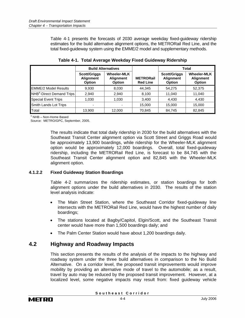
Table 4-1 presents the forecasts of 2030 average weekday fixed-guideway ridership estimates for the build alternative alignment options, the METRORail Red Line, and the total fixed-guideway system using the EMME/2 model and supplementary methods.
Table 4-1. Total Average Weekday Fixed Guideway Ridership
Build Alternatives Total
Scott/Griggs Alignment
Option
Wheeler-MLK Alignment
Option METRORail
Red Line
Scott/Griggs Alignment
Option
Wheeler-MLK Alignment
Option EMME/2 Model Results 9,930 8,030 44,345 54,275 52,375 NHBa-Direct Demand Trips 2,940 2,940 8,100 11,040 11,040 Special Event Trips 1,030 1,030 3,400 4,430 4,430 Smith Lands Lot Trips - - 15,000 15,000 15,000 Total 13,900 12,000 70,845 84,745 82,845
a NHB – Non-Home Based Source: METRO/GPC, September, 2005.
The results indicate that total daily ridership in 2030 for the build alternatives with the Southeast Transit Center alignment option via Scott Street and Griggs Road would be approximately 13,900 boardings, while ridership for the Wheeler-MLK alignment option would be approximately 12,000 boardings. Overall, total fixed-guideway ridership, including the METRORail Red Line, is forecast to be 84,745 with the Southeast Transit Center alignment option and 82,845 with the Wheeler-MLK alignment option.
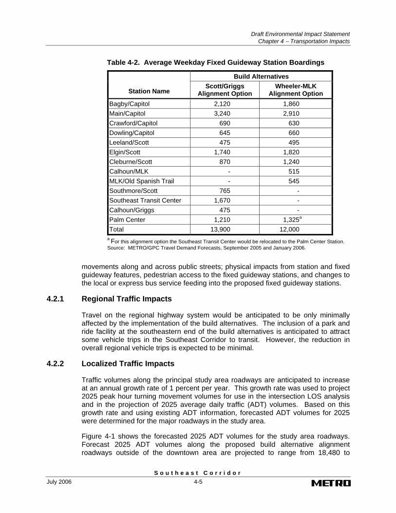
4.1.2.2 Fixed Guideway Station Boardings
Table 4-2 summarizes the ridership estimates, or station boardings for both alignment options under the build alternatives in 2030. The results of the station level analysis indicate:
• The Main Street Station, where the Southeast Corridor fixed-guideway line intersects with the METRORail Red Line, would have the highest number of daily boardings;
• The stations located at Bagby/Capitol, Elgin/Scott, and the Southeast Transit center would have more than 1,500 boardings daily; and
• The Palm Center Station would have about 1,200 boardings daily.
4.2 Highway and Roadway Impacts
This section presents the results of the analysis of the impacts to the highway and roadway system under the three build alternatives in comparison to the No Build Alternative. On a corridor level, the proposed transit improvements would improve mobility by providing an alternative mode of travel to the automobile; as a result, travel by auto may be reduced by the proposed transit improvement. However, at a localized level, some negative impacts may result from: fixed guideway vehicle
Draft Environmental Impact Statement
Chapter 4 − Transportation Impacts
S o u t h e a s t C o r r i d o r July 2006 4-5
Table 4-2. Average Weekday Fixed Guideway Station Boardings
Build Alternatives
Station Name Scott/Griggs
Alignment Option Wheeler-MLK
Alignment Option Bagby/Capitol 2,120 1,860 Main/Capitol 3,240 2,910 Crawford/Capitol 690 630 Dowling/Capitol 645 660 Leeland/Scott 475 495 Elgin/Scott 1,740 1,820 Cleburne/Scott 870 1,240 Calhoun/MLK - 515 MLK/Old Spanish Trail - 545 Southmore/Scott 765 - Southeast Transit Center 1,670 - Calhoun/Griggs 475 - Palm Center 1,210 1,325a Total 13,900 12,000
a For this alignment option the Southeast Transit Center would be relocated to the Palm Center Station. Source: METRO/GPC Travel Demand Forecasts, September 2005 and January 2006.
movements along and across public streets; physical impacts from station and fixed guideway features, pedestrian access to the fixed guideway stations, and changes to the local or express bus service feeding into the proposed fixed guideway stations.
4.2.1 Regional Traffic Impacts
Travel on the regional highway system would be anticipated to be only minimally affected by the implementation of the build alternatives. The inclusion of a park and ride facility at the southeastern end of the build alternatives is anticipated to attract some vehicle trips in the Southeast Corridor to transit. However, the reduction in overall regional vehicle trips is expected to be minimal.
4.2.2 Localized Traffic Impacts
Traffic volumes along the principal study area roadways are anticipated to increase at an annual growth rate of 1 percent per year. This growth rate was used to project 2025 peak hour turning movement volumes for use in the intersection LOS analysis and in the projection of 2025 average daily traffic (ADT) volumes. Based on this growth rate and using existing ADT information, forecasted ADT volumes for 2025 were determined for the major roadways in the study area.
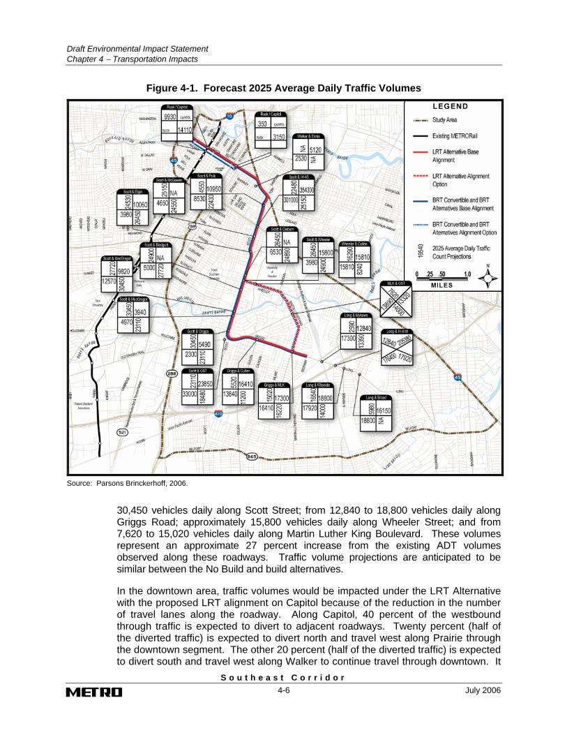
Figure 4-1 shows the forecasted 2025 ADT volumes for the study area roadways. Forecast 2025 ADT volumes along the proposed build alternative alignment roadways outside of the downtown area are projected to range from 18,480 to
Draft Environmental Impact Statement Chapter 4 − Transportation Impacts
S o u t h e a s t C o r r i d o r 4-6 July 2006
Figure 4-1. Forecast 2025 Average Daily Traffic Volumes
Source: Parsons Brinckerhoff, 2006.
30,450 vehicles daily along Scott Street; from 12,840 to 18,800 vehicles daily along Griggs Road; approximately 15,800 vehicles daily along Wheeler Street; and from 7,620 to 15,020 vehicles daily along Martin Luther King Boulevard. These volumes represent an approximate 27 percent increase from the existing ADT volumes observed along these roadways. Traffic volume projections are anticipated to be similar between the No Build and build alternatives.
In the downtown area, traffic volumes would be impacted under the LRT Alternative with the proposed LRT alignment on Capitol because of the reduction in the number of travel lanes along the roadway. Along Capitol, 40 percent of the westbound through traffic is expected to divert to adjacent roadways. Twenty percent (half of the diverted traffic) is expected to divert north and travel west along Prairie through the downtown segment. The other 20 percent (half of the diverted traffic) is expected to divert south and travel west along Walker to continue travel through downtown. It
Draft Environmental Impact Statement
Chapter 4 − Transportation Impacts
S o u t h e a s t C o r r i d o r July 2006 4-7
is also expected that 40 percent of the vehicles that would make turning movements onto Capitol from the northbound and southbound cross streets would also be diverted to Prairie and Walker. Twenty percent (half of the diverted traffic) is expected to turn at the westbound street prior to Capitol. The other 20 percent (half of the diverted traffic) is expected to travel through the Capitol intersection and turn at the next westbound street.
Traffic volumes in the downtown area would not be impacted under the BRT alternatives with the BRT alignment on Capitol and Rusk.
4.2.3 Corridor Street Modifications
This section discusses the impacts related to modification of the street system to accommodate the build alternative alignment options in the center or on the side of the street.
4.2.3.1 Downtown LRT Alternative Alignment between Bagby and St. Emanuel
The proposed fixed-guideway alignment in downtown under the LRT Alternative would begin at mid-block on Capitol between Bagby and Smith. Capitol is a one-way westbound street in downtown. The LRT alignment would be located in the center of the street with one lane of traffic on each side of the alignment. At Travis, the alignment would transition to the south side of the street and remain along the south side of the street from Travis to St. Emanuel.
To accommodate the in-street LRT alignment, the number of through traffic lanes on Capitol would be reduced in a number of blocks. Between Bagby and Travis, where the LRT alignment would be in the center of the street, the number of lanes would be reduced to one lane on each side of the fixed guideway. At the transition to the south side of the street in the block between Milam and Travis, one lane would be maintained on the north side of the alignment. East of Travis, the trackway alignment would continue on the south side of the street, with two lanes north of the alignment from Travis to Austin and three lanes from Austin to Chartres. East of Chartres, two lanes would be maintained north of the alignment. Left turns would be restricted at most signalized intersections along Capitol in downtown.
4.2.3.2 Downtown BRT Alternative Alignment between Bagby and St. Emanuel
Under the BRT alternatives, BRT vehicles would operate on Capitol and Rusk between Bagby and St. Emanuel within reserved lanes for buses, high occupancy vehicles (HOVs), and right turning traffic. Westbound on Capitol, the BRT vehicles would maneuver from the south curb lane to the north curb lane at St. Emanuel and continue west on Capitol to Bagby. At Bagby, the vehicles would make a U-turn and maneuver to the south curb lane of Rusk and continue east to St. Emanuel. At St. Emanuel, the vehicles would turn north and enter the east curb lane where it would continue to Capitol. At Capitol, the alignment would turn east onto Capitol. The remaining two westbound traffic lanes on Capitol and two eastbound lanes on Rusk would be maintained and no improvements would be made to the downtown intersections. Most traffic signals would remain unchanged with the exception of Capitol at St. Emanuel and Capitol and Rusk at Bagby.
Draft Environmental Impact Statement Chapter 4 − Transportation Impacts
S o u t h e a s t C o r r i d o r 4-8 July 2006
4.2.3.3 Build Alternatives Alignment between St. Emanuel and Wheeler Street
The fixed-guideway alignment under the build alternatives would continue along the south side of the Capitol from St. Emanuel to Paige in the vicinity of the Burlington Northern Santa Fe Railway (BNSF) tracks. Two travel lanes would be provided on the north side of the fixed guideway. The alignment would then turn southeast at-grade and would cross diagonally through several city blocks to Sampson and Scott Streets. At the intersection where Sampson Street turns into Scott Street, the alignment would turn south and continue at grade in the middle of Scott Street to IH-45. The existing median width of 30 feet in this section is of sufficient width to accommodate the fixed guideway while maintaining the existing two lanes of traffic in each direction.
For the LRT Alternative, Scott Street would have to be lowered at the freeway bridge crossing, or over-height vehicles re-routed around the interchange due to inadequate clearance under IH-45 for the LRT trackway and overhead contact system. For the BRT Convertible Alternative, Scott Street would not be lowered.
After crossing under IH-45, the alignment would continue in the middle of Scott Street to Elgin Street. The existing six lanes of traffic along Scott Street would be reduced to two travel lanes in each direction to accommodate the fixed guideway within the roadway. Protected left-turn lanes and local access needs would be incorporated into the design where appropriate. From the Elgin Street intersection, the alignment would continue south at-grade in the median of Scott Street to Wheeler Street. The existing four lanes of traffic would be maintained along the roadway with protected left turn lanes and local access where required.
Although the streets outside of downtown would be modified to accommodate the fixed-guideway alignment and stations, the existing number of traffic lanes on Scott Street would be maintained under the both build alternatives. Localized impacts are anticipated at 15 non-signalized intersections along Scott Street because the location of the fixed guideway in the median of the roadway would restrict left-turn and cross street through movements at these intersections. Traffic that currently makes these movements along Scott Street would need to divert to adjacent signalized intersections. While this diversion of traffic is not anticipated to be substantial, the diverted traffic volumes have been accounted for in the analysis. In addition, pedestrian movements across the median at these intersections would be prohibited. These intersections are on Scott Street at Denver, Bell, Pease, Jefferson, Coyle, McIlhenny, Bremond, Dennis, Drew, Taum, Anita, Rosalie, Simmons, Reeves, Alabama, and Eagle.
4.2.3.4 Build Alternatives Alignment between Wheeler Street and Beekman Road
The fixed-guideway alignment under the build alternatives would continue south at grade in the median of Scott Street to Griggs Road. The existing four lanes of traffic would be maintained along the roadway with protected left-turn lanes and local access where required. At the Griggs Road intersection, the alignment would curve to the east, cross through the intersection and turn east parallel to the south side of the Old Spanish Trail from Scottcrest Drive to Griggs Road. The location of the alignment off to the side of the roadway would avoid impacts to the number of lanes along Old Spanish Trail through this area. The alignment would enter the median on
Draft Environmental Impact Statement
Chapter 4 − Transportation Impacts
S o u t h e a s t C o r r i d o r July 2006 4-9
Griggs Road and continue east on Griggs Road to a point east of the Martin Luther King Boulevard near Beekman Road. The existing median along Griggs Road would allow for the inclusion of the alignment without impacting the number of lanes along the roadway.
Localized traffic impacts are anticipated at 20 non-signalized intersections along Scott Street and Griggs Road because the location of the fixed guideway in the median of the roadway would restrict left-turn and cross street through movements at these intersections. Traffic that currently makes these movements would need to divert to adjacent signalized intersections. While this diversion of traffic is not anticipated to be substantial, the diverted traffic volumes have been accounted for in the analysis. In addition, pedestrian movements across the median at these intersections would be prohibited These intersections are on Scott Street at Rosewood, Wichita, Ruth, Wentworth, Arbor, Rosedale, Palm, Gertin, Rio Vista, Julius, Parkwood, and Charleston Streets; and on Griggs Road at Foster, Eastwood, Wayland, Grace, Carol, Shroeder, Cavanaugh, and Royal Palms..
4.2.3.5 Build Alternatives Wheeler-MLK Alignment Option
Under the Wheeler-MLK alignment option, the proposed fixed-guideway alignment under the build alternatives would curve to the east at Wheeler Street and continue east at-grade in the median of Wheeler Street to Martin Luther King Boulevard. This curve in the alignment would intercept the northbound lanes of Scott Street north of Wheeler Street and the westbound lanes of Wheeler Street east of Scott Street. The conflicting movements at these mid-block crossings will require control by means of traffic signals or flashing lights and automatic gates. The existing one lane of travel in each direction would be maintained along Wheeler Street on each side of the fixed-guideway alignment. East of Calhoun Road, the alignment would turn south at-grade into the median of Martin Luther King Boulevard. Along Martin Luther King Boulevard, the existing three travel lanes in each direction along the roadway would be maintained, although some minor lane width reductions may be necessary. North of the Griggs Road intersection, the alignment would curve to the east at Griggs Road and continue in the median to Beekman Road. This curve in the alignment would require traffic signals or flashing lights with automatic gates just north and east of the intersection to allow the fixed guideway to safely cross the existing travel lanes along Martin Luther King Boulevard and Griggs Road.
Localized impacts are anticipated at eight non-signalized intersections along Wheeler Street and Martin Luther King Boulevard because the location of the fixed guideway in the median of the roadway would restrict left-turn and through movements at these intersections. Traffic that currently makes these movements would need to divert to adjacent signalized intersections. While this diversion of traffic is not anticipated to be substantial, the diverted traffic volumes have been accounted for in the analysis. In addition, pedestrian movements across the median at these intersections would be prohibited except where noted. These intersections are on Wheeler Street at Cougar Place (pedestrian crossing accommodation), Rockwood Drive (pedestrian crossing accommodation), and an access driveway to University Drive, and on Martin Luther King Boulevard at Winnetka Avenue, Marietta Lane, Ventura Lane, Albemarle Lane, and Stuyvesant Lane. Similar to the Southeast Transit Center alignment option on Griggs Road, the non-signalized
Draft Environmental Impact Statement Chapter 4 − Transportation Impacts
S o u t h e a s t C o r r i d o r 4-10 July 2006
intersections on Griggs Road at Cavanuagh Street, and Royal Palms would be impacted by the location of the fixed guideway in the median of the roadway.
4.2.3.6 LRT Alternative Maintenance and Storage Facility
The LRT Alternative would require a new maintenance and storage facility. The proposed site for the LRT vehicle storage and maintenance facility is located south of the fixed guideway alignment east of Dowling. The land acquisition required for the vehicle storage yard and maintenance center under the LRT Alternative would include some public street rights-of-way. This would require closure or vacating all or portions of several streets within the area of the proposed site. The following street segments are likely to be affected:
• Capitol between Nagel and the BNSF right-of-way
• Rusk between Delano and the BNSF right-of-way
• Walker between Paige and the BNSF right-of-way
• Delano between Rusk and Capitol
• Paige between Walker and Capitol
• Ennis between McKinney and the BNSF right-of-way
The potential closure or vacating of the above streets would result in potential changes to the operation of the adjacent intersections. These changes could include the elimination of a leg at an intersection, a reduction in the traffic volumes on the impacted approach, and changes to the stop control operation at the intersections. Any impacts associated with these changes to the intersections in this area would be anticipated to be minor in nature and not create any significant impacts.
4.2.4 Signalized Intersection Modifications
Signalized intersections along the proposed build alternative alignments would be impacted by the inclusion of transit operations along the roadways, however the modifications and impacts would vary based on the technology variation and the alignment options associated with the build alternatives. In general, the signalized intersections along the fixed guideway alignment would operate on a predictive-priority condition that would allow the parallel through traffic to move during the same signal phase as the fixed guideway vehicle. As a result, the inclusion of the LRT or BRT movements in the signal phase is not anticipated to substantially impact operations along the corridor roadway and at signalized intersections. The inclusion of the fixed-guideway alignment in the roadway network would require all interfaces of LRT or BRT movements with vehicle and general pedestrian traffic be controlled by active devices. That control may be supplemented by passive measures.
4.2.4.1 Downtown LRT Alternative Alignment between Bagby and St. Emanuel
Capacity impacts would occur at a number of downtown intersections along the LRT alignment where there would be no separate lanes for turns across the LRT trackway from parallel lanes. In order to allow the LRT vehicles and through traffic on those
Draft Environmental Impact Statement
Chapter 4 − Transportation Impacts
S o u t h e a s t C o r r i d o r July 2006 4-11
roadways to move on the same signal phase, left turns across the LRT trackway would be prohibited at most signalized intersections on Capitol and diverted to other roadways. The intersections on Capitol where currently legal left turns onto cross streets would be prohibited include Brazos, Smith, Milam, Main, Fannin, Caroline, La Branch, Jackson, Avenue de las Amaericas, Chenevert, Hamilton, Chartres, St. Emanuel, Hutchins, Bastrop, Dowling, St. Charles, and Live Oak.
4.2.4.2 Downtown BRT Alternative Alignment between Bagby and St. Emanuel
Under the BRT Alternatives, the operation of BRT vehicles in reserved lanes would not substantially impact signalized intersection operations along Capitol and Rusk. Because no turning movement restrictions would be incorporated into the signal operations, no significant impact to the overall traffic operations throughout downtown would be anticipated under the Build Alternative with the BRT variation.
4.2.4.3 Fixed-Guideway Alignment between St. Emanuel and Wheeler Street
At six existing signalized intersections along Scott Street south to Wheeler Street, left turns would be accommodated across the fixed guideway with a new left-turn signal phase that would operate as a protected only phase. This additional phase in the signal operations would have some impact on overall capacity at the intersection. These intersections are on Scott Street at Leeland, McGowen, Elgin, Holman, Cleburne, and Wheeler Streets.
Several new traffic signals are proposed under the build alternatives at existing unsignalized intersections along the fixed-guideway alignment between St. Emanuel and Wheeler Street. The intersection operations would control vehicular movements across the fixed guideway through the intersection on separate phases. Pedestrian movements across the fixed guideway at these locations would also be controlled. These locations include the following two intersections:
• McKinney Avenue and Roberts Street
• Sampson Street and Lamar Street
• Scott Street and IH-45 Southbound On-ramp
• Scott Street and IH-45 Northbound Off-ramp
One other signalized intersection in this segment of Scott Street would require traffic control modifications at the existing intersection to accommodate the fixed guideway. At the intersection of Scott and Polk Streets, the median on the north and south legs would be reconfigured so that it would extend into the “shadows” of the northbound and southbound left-turn lanes. This added median width would provide a refuge for pedestrians stranded in mid crossing at the end of the signal phase. The signal phase serving the northbound and southbound left turns at these intersections would be protected only.
Draft Environmental Impact Statement Chapter 4 − Transportation Impacts
S o u t h e a s t C o r r i d o r 4-12 July 2006
4.2.4.4 Fixed-Guideway Alignment between Wheeler Street and Beekman Road
At three existing signalized intersections along Scott Street and four existing signalized intersections along Griggs Road under the Southeast Transit Center Alignment Option, left turns would be accommodated across the fixed guideway with a new left-turn signal phase that would operate as a protected only phase. This additional phase in the signal operations would have some effect on overall capacity at the intersections. These intersections are on Scott Street at Blodgett Street, Southmore Street, North MacGregor Way, South MacGregor Way, and Griggs Road; and on Griggs Road at Cullen Boulevard, Calhoun Road, Milart Street, and Martin Luther King Boulevard.
Several new traffic signals are proposed under the build alternatives along Scott Street and Griggs Road under the Southeast Transit Center Alignment Option. These traffic signals would operate with protected only left-turn movements from Scott Street and Griggs Road across the fixed guideway. These locations include the following three intersections:
• Scott Street and Southmore Boulevard
• Griggs Road and Milart Street
• Griggs Road and Beekman Street
At the Griggs Road and Gosforth Street intersection, the location of the guideway through the intersection would require an additional phase to serve the guideway vehicle movement which could run concurrently with the westbound Griggs Road traffic. In addition, on the southwest corner of the Griggs Road and Gosforth Street intersection, a separate set of signals would be needed to control pedestrian movements across the fixed guideway.
Other existing signalized intersections in this section would require traffic control modifications to accommodate the fixed guideway. These intersections as well as the identified modifications are listed below:
• Scott Street and Griggs Road − At the intersection of Scott Street and Griggs Road, the signal controller would need to be reprogrammed to accommodate an additional phase into the cycle whenever an approaching transit vehicle is detected. During that phase, all traffic movements would be stopped except for pedestrian movements on the south, east, and west crosswalks and for southbound through-right vehicle movements. The signal phase serving the southbound left turns from Scott Street also would be protected only. Separate signal control would be needed to regulate pedestrian movements across the fixed guideway on the southeast corner.
• Scottcrest and Old Spanish Trail − At this intersection, the signal controller would need to be reprogrammed to accommodate an additional phase into the cycle whenever an approaching fixed guideway vehicle is detected. During that phase, all vehicle movements would have to be stopped, except right turn movements from Old Spanish Trail. Separate signal control would be needed to regulate pedestrian movements across the fixed guideway on the northwest and southeast corners.
Draft Environmental Impact Statement
Chapter 4 − Transportation Impacts
S o u t h e a s t C o r r i d o r July 2006 4-13
• The modification of the streets to accommodate the fixed guideway under the Southeast Transit Center alignment option would include the construction of a new street along the south side of the fixed guideway between St. Augustine Street and Gosforth Street. St. Augustine Street, Conley Street, England Street, Sidney Street and Gosforth Street would be closed at the fixed guideway and the new street would provide circulation between these five streets south of the closure. North of the fixed guideway Conley Street, England Street and Sidney Street would become short no-outlet streets to provide access to abutting properties. Dupont Avenue would also be closed between St. Augustine Street and England Street as a result of the inclusion of the fixed guideway.
4.2.4.5 Wheeler-MLK Alignment Option
Under the Wheeler-MLK alignment option, several new traffic signals with separate left-turn lanes are proposed along Martin Luther King Boulevard. These traffic signals would operate with protected only left-turn movements. These intersections are located on Martin Luther King Boulevard at MacGregor Way, Arvilla Lane, Madalyn Lane, and Cortelyou Lane
Other intersections along this alignment option would require traffic control installations or modifications and physical changes to the existing intersection to accommodate the fixed guideway. These intersections as well as the identified modifications are listed below:
• Wheeler Street and University Oaks Boulevard – The currently envisioned location of the proposed University Station would require widening of the Wheeler Street right of way through the acquisition of private property to provide space for a center platform and a separate left-turn lane. A new traffic signal with a signal phase serving the westbound left-turn and eastbound u-turn movements operating as a protected only phase would be required.
• Wheeler Street, Calhoun Road, and Martin Luther King Boulevard − The geometry at this intersection already requires a complex signal phasing. An additional signal phase would be required to accommodate the movements on the fixed guideway. The addition of this phase to the signal cycle will impact the overall traffic operations at this intersection.
• Martin Luther King Boulevard and Old Spanish Trail – The fixed guideway would intercept Old Spanish trail at a new signalized intersection midway between the two existing signalized intersections. This would affect the lanes available for queuing left turn traffic. Significant revision to the roadway geometry would be needed to minimize the impact of this new intersection. Left turns from Old Spanish Trail would be allowed at the new intersection but left turning traffic from Martin Luther King Boulevard would be accommodated from the existing loop roadway intersections. This would eliminate the need for protected left turn bays and signal phase on Martin Luther King Boulevard at the new centralized intersection. The Arvilla Station would be accommodated across the intersection and would require widening of the Martin Luther King Boulevard right-of-way to provide space for a center platform.

Draft Environmental Impact Statement Chapter 4 − Transportation Impacts
S o u t h e a s t C o r r i d o r 4-14 July 2006
The existing signalized pedestrian crossing at Wheeler and Rockwood would be retained under this alignment option. In addition, three mid-block pedestrian crossings on Wheeler Street and one crossing on Martin Luther King Boulevard are proposed under the Wheeler-MLK alignment option. These proposed crossings would be located along Wheeler Street east of Cougar Place, at University Oaks Boulevard, and east of University Oaks Boulevard near the proposed University Station. The proposed crossing on Martin Luther King Boulevard would be located north of Winnetka Lane. The pedestrian crossing at University Oaks Boulevard would be incorporated into the operation of the proposed signal at that intersection location. At all proposed pedestrian crossings, a refuge zone in the proposed median of the fixed guideway should be incorporated into the crossing design to account for any pedestrians stranded when crossing the guideway.
Four non-intersection guideway crossings would be required under the Wheeler-MLK alignment option. At these locations, Scott Street north of Wheeler Street, Wheeler Street east of Scott Street, Martin Luther King Boulevard north of Griggs Road, and Griggs Road east of Martin Luther King Boulevard, vehicle movements across the tracks would need to be controlled by traffic signals and/or flashing lights and automatic gates. Those devices would be interconnected with the traffic signal controller at Scott Street and Wheeler Street, which would be programmed to insert a pre-emption sequence into the cycle whenever the crossing control equipment is activated. Additional control devices would be installed to address pedestrian movements on the sidewalks that intercept the fixed guideway.
The intersections of Scott Street and Wheeler Street and Martin Luther King Boulevard and Griggs Road under the Wheeler-MLK alignment option would not be physically impacted by the fixed-guideway alignment. As noted however, adjacent non-intersection crossings of the fixed guideway may result in minor impacts to the traffic flow at these intersections, particularly if those crossings are controlled by flashing lights and automatic gates. The intersection operations between these guideway crossings and signalized intersections would be coordinated to reduce overall operational impacts.
4.2.5 Impacts on Level of Service at Intersections
Levels of service at signalized intersections during the a.m. and p.m. peak hours in 2025 were identified for the No Build and build alternatives. The analysis was conducted using procedures as described in the Transportation Research Board’s 2000 Edition Highway Capacity Manual (HCM). The results of the analysis are summarized in the following sections. A roadway operating at LOS A through D is considered to be operating at an acceptable condition, while a roadway operating at LOS E or F is considered to be operating at a deficient LOS.
4.2.5.1 Impacts under No Build Alternative
A LOS analysis was conducted for signalized intersections in the downtown area and outside of downtown along Scott Street, Griggs Road, Wheeler Street, and Martin Luther King Boulevard under the No Build Alternative in 2025. The purpose of the analysis was to determine what conditions would be in 2025 without the project. The results of the analysis are discussed below.
Draft Environmental Impact Statement
Chapter 4 − Transportation Impacts
S o u t h e a s t C o r r i d o r July 2006 4-15
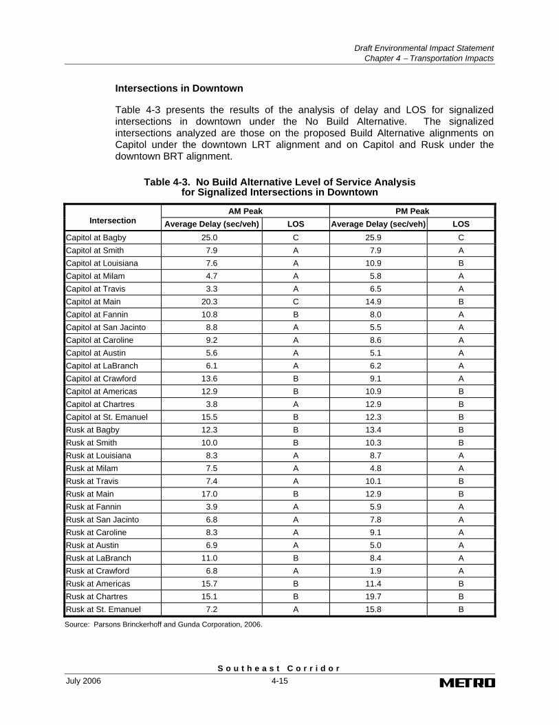
Intersections in Downtown
Table 4-3 presents the results of the analysis of delay and LOS for signalized intersections in downtown under the No Build Alternative. The signalized intersections analyzed are those on the proposed Build Alternative alignments on Capitol under the downtown LRT alignment and on Capitol and Rusk under the downtown BRT alignment.
Table 4-3. No Build Alternative Level of Service Analysis for Signalized Intersections in Downtown
AM Peak PM Peak Intersection Average Delay (sec/veh) LOS Average Delay (sec/veh) LOS
Capitol at Bagby 25.0 C 25.9 C Capitol at Smith 7.9 A 7.9 A Capitol at Louisiana 7.6 A 10.9 B Capitol at Milam 4.7 A 5.8 A Capitol at Travis 3.3 A 6.5 A Capitol at Main 20.3 C 14.9 B Capitol at Fannin 10.8 B 8.0 A Capitol at San Jacinto 8.8 A 5.5 A Capitol at Caroline 9.2 A 8.6 A Capitol at Austin 5.6 A 5.1 A Capitol at LaBranch 6.1 A 6.2 A Capitol at Crawford 13.6 B 9.1 A Capitol at Americas 12.9 B 10.9 B Capitol at Chartres 3.8 A 12.9 B Capitol at St. Emanuel 15.5 B 12.3 B Rusk at Bagby 12.3 B 13.4 B Rusk at Smith 10.0 B 10.3 B Rusk at Louisiana 8.3 A 8.7 A Rusk at Milam 7.5 A 4.8 A Rusk at Travis 7.4 A 10.1 B Rusk at Main 17.0 B 12.9 B Rusk at Fannin 3.9 A 5.9 A Rusk at San Jacinto 6.8 A 7.8 A Rusk at Caroline 8.3 A 9.1 A Rusk at Austin 6.9 A 5.0 A Rusk at LaBranch 11.0 B 8.4 A Rusk at Crawford 6.8 A 1.9 A Rusk at Americas 15.7 B 11.4 B Rusk at Chartres 15.1 B 19.7 B Rusk at St. Emanuel 7.2 A 15.8 B
Source: Parsons Brinckerhoff and Gunda Corporation, 2006.
Draft Environmental Impact Statement Chapter 4 − Transportation Impacts
S o u t h e a s t C o r r i d o r 4-16 July 2006
As indicated in the table, all intersections analyzed are expected to operate with acceptable overall levels of service during both the a.m. and p.m. peak hours. Levels of service range from A to C for overall operations, with most intersections operating at a LOS A or B during both a.m. and p.m. peak hours. Average vehicle delays range from 3.3 seconds/vehicle to 25.9 seconds/vehicle at the signalized intersections during both peak hours.
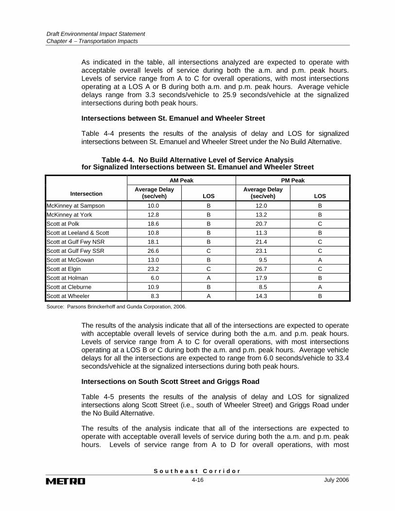
Intersections between St. Emanuel and Wheeler Street
Table 4-4 presents the results of the analysis of delay and LOS for signalized intersections between St. Emanuel and Wheeler Street under the No Build Alternative.
Table 4-4. No Build Alternative Level of Service Analysis for Signalized Intersections between St. Emanuel and Wheeler Street
AM Peak PM Peak
Intersection Average Delay
(sec/veh) LOS Average Delay
(sec/veh) LOS McKinney at Sampson 10.0 B 12.0 B McKinney at York 12.8 B 13.2 B Scott at Polk 18.6 B 20.7 C Scott at Leeland & Scott 10.8 B 11.3 B Scott at Gulf Fwy NSR 18.1 B 21.4 C Scott at Gulf Fwy SSR 26.6 C 23.1 C Scott at McGowan 13.0 B 9.5 A Scott at Elgin 23.2 C 26.7 C Scott at Holman 6.0 A 17.9 B Scott at Cleburne 10.9 B 8.5 A Scott at Wheeler 8.3 A 14.3 B
Source: Parsons Brinckerhoff and Gunda Corporation, 2006.
The results of the analysis indicate that all of the intersections are expected to operate with acceptable overall levels of service during both the a.m. and p.m. peak hours. Levels of service range from A to C for overall operations, with most intersections operating at a LOS B or C during both the a.m. and p.m. peak hours. Average vehicle delays for all the intersections are expected to range from 6.0 seconds/vehicle to 33.4 seconds/vehicle at the signalized intersections during both peak hours.
Intersections on South Scott Street and Griggs Road
Table 4-5 presents the results of the analysis of delay and LOS for signalized intersections along Scott Street (i.e., south of Wheeler Street) and Griggs Road under the No Build Alternative.
The results of the analysis indicate that all of the intersections are expected to operate with acceptable overall levels of service during both the a.m. and p.m. peak hours. Levels of service range from A to D for overall operations, with most
Draft Environmental Impact Statement
Chapter 4 − Transportation Impacts
S o u t h e a s t C o r r i d o r July 2006 4-17
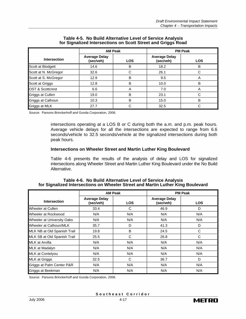
Table 4-5. No Build Alternative Level of Service Analysis for Signalized Intersections on Scott Street and Griggs Road
AM Peak PM Peak
Intersection Average Delay
(sec/veh) LOS Average Delay
(sec/veh) LOS Scott at Blodgett 14.6 B 18.2 B Scott at N. McGregor 32.6 C 26.1 C Scott at S. McGregor 12.9 B 9.5 A Scott at Griggs 12.8 B 10.0 B OST & Scottcrest 6.6 A 7.0 A Griggs at Cullen 19.0 B 23.1 C Griggs at Calhoun 10.3 B 15.0 B Griggs at MLK 27.7 C 32.5 C
Source: Parsons Brinckerhoff and Gunda Corporation, 2006.
intersections operating at a LOS B or C during both the a.m. and p.m. peak hours. Average vehicle delays for all the intersections are expected to range from 6.6 seconds/vehicle to 32.5 seconds/vehicle at the signalized intersections during both peak hours.
Intersections on Wheeler Street and Martin Luther King Boulevard
Table 4-6 presents the results of the analysis of delay and LOS for signalized intersections along Wheeler Street and Martin Luther King Boulevard under the No Build Alternative.
Table 4-6. No Build Alternative Level of Service Analysis for Signalized Intersections on Wheeler Street and Martin Luther King Boulevard
AM Peak PM Peak
Intersection Average Delay
(sec/veh) LOS Average Delay
(sec/veh) LOS Wheeler at Cullen 33.4 C 46.9 D Wheeler at Rockwood N/A N/A N/A N/A Wheeler at University Oaks N/A N/A N/A N/A Wheeler at Calhoun/MLK 35.7 D 41.3 D MLK NB at Old Spanish Trail 19.8 B 24.5 C MLK SB at Old Spanish Trail 25.5 C 26.8 C MLK at Arvilla N/A N/A N/A N/A MLK at Madalyn N/A N/A N/A N/A MLK at Contelyou N/A N/A N/A N/A MLK at Griggs 32.5 C 36.7 D Griggs at Palm Center P&R N/A N/A N/A N/A Griggs at Beekman N/A N/A N/A N/A
Source: Parsons Brinckerhoff and Gunda Corporation, 2006.
Draft Environmental Impact Statement Chapter 4 − Transportation Impacts
S o u t h e a s t C o r r i d o r 4-18 July 2006
The results of the analysis indicate that all of the intersections are expected to operate with acceptable overall levels of service during both the a.m. and p.m. peak hours. Levels of service range from B to D for overall operations, with most intersections operating at a LOS C during both the a.m. and p.m. peak hours. Average vehicle delays for all the intersections are expected to range from 19.8 seconds/vehicle to 46.9 seconds/vehicle at the signalized intersections during both peak hours.
4.2.5.2 Impacts under the Build Alternatives
A level of service analysis was conducted for all signalized intersections in downtown and outside downtown along the fixed-guideway alignment under the build alternatives in 2025. The analysis was based on the revised traffic signalized operations needed to accommodate the transit vehicle movements through intersection crossings and modified intersection geometrics as shown on the plan drawings contained in Volume 2 of this DEIS. The results of the analysis are discussed below.
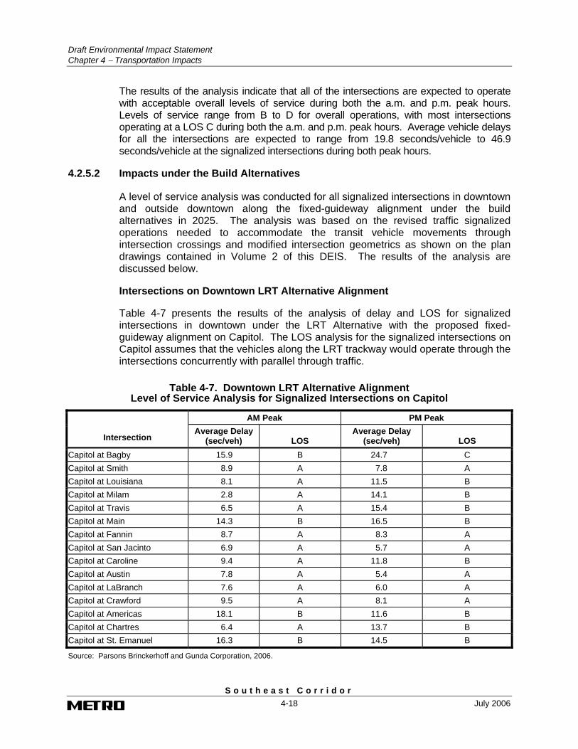
Intersections on Downtown LRT Alternative Alignment
Table 4-7 presents the results of the analysis of delay and LOS for signalized intersections in downtown under the LRT Alternative with the proposed fixed-guideway alignment on Capitol. The LOS analysis for the signalized intersections on Capitol assumes that the vehicles along the LRT trackway would operate through the intersections concurrently with parallel through traffic.
Table 4-7. Downtown LRT Alternative Alignment Level of Service Analysis for Signalized Intersections on Capitol
AM Peak PM Peak
Intersection Average Delay
(sec/veh) LOS Average Delay
(sec/veh) LOS Capitol at Bagby 15.9 B 24.7 C Capitol at Smith 8.9 A 7.8 A Capitol at Louisiana 8.1 A 11.5 B Capitol at Milam 2.8 A 14.1 B Capitol at Travis 6.5 A 15.4 B Capitol at Main 14.3 B 16.5 B Capitol at Fannin 8.7 A 8.3 A Capitol at San Jacinto 6.9 A 5.7 A Capitol at Caroline 9.4 A 11.8 B Capitol at Austin 7.8 A 5.4 A Capitol at LaBranch 7.6 A 6.0 A Capitol at Crawford 9.5 A 8.1 A Capitol at Americas 18.1 B 11.6 B Capitol at Chartres 6.4 A 13.7 B Capitol at St. Emanuel 16.3 B 14.5 B
Source: Parsons Brinckerhoff and Gunda Corporation, 2006.
Draft Environmental Impact Statement
Chapter 4 − Transportation Impacts
S o u t h e a s t C o r r i d o r July 2006 4-19
Left turns across the trackway would be prohibited at most intersections. While no physical impacts are anticipated to occur along Rusk under the downtown LRT alignment, minor fluctuations in localized travel patterns are anticipated as a result of the diversion of traffic. These fluctuations are not anticipated to impact the operations of the intersections.
The results indicate that overall levels of service at most intersections on Capitol under the LRT Alternative with the downtown LRT alignment would remain similar to those conditions identified under the No Build Alternative. This is a result of the diversion traffic from Capitol as a result of the reduction in number of through traffic lanes on Capitol under the LRT Alternative. With the diversion of traffic, all of the intersections on Capitol are expected to operate with acceptable overall levels of service during both the a.m. and p.m. peak hours. Levels of service range from A to C for overall operations, with most intersections operating at a LOS A or B during both the a.m. and p.m. peak hours. Average vehicle delays for all the intersections are projected to range from 2.8 seconds/vehicle to 24.7 seconds/vehicle during both peak hours.
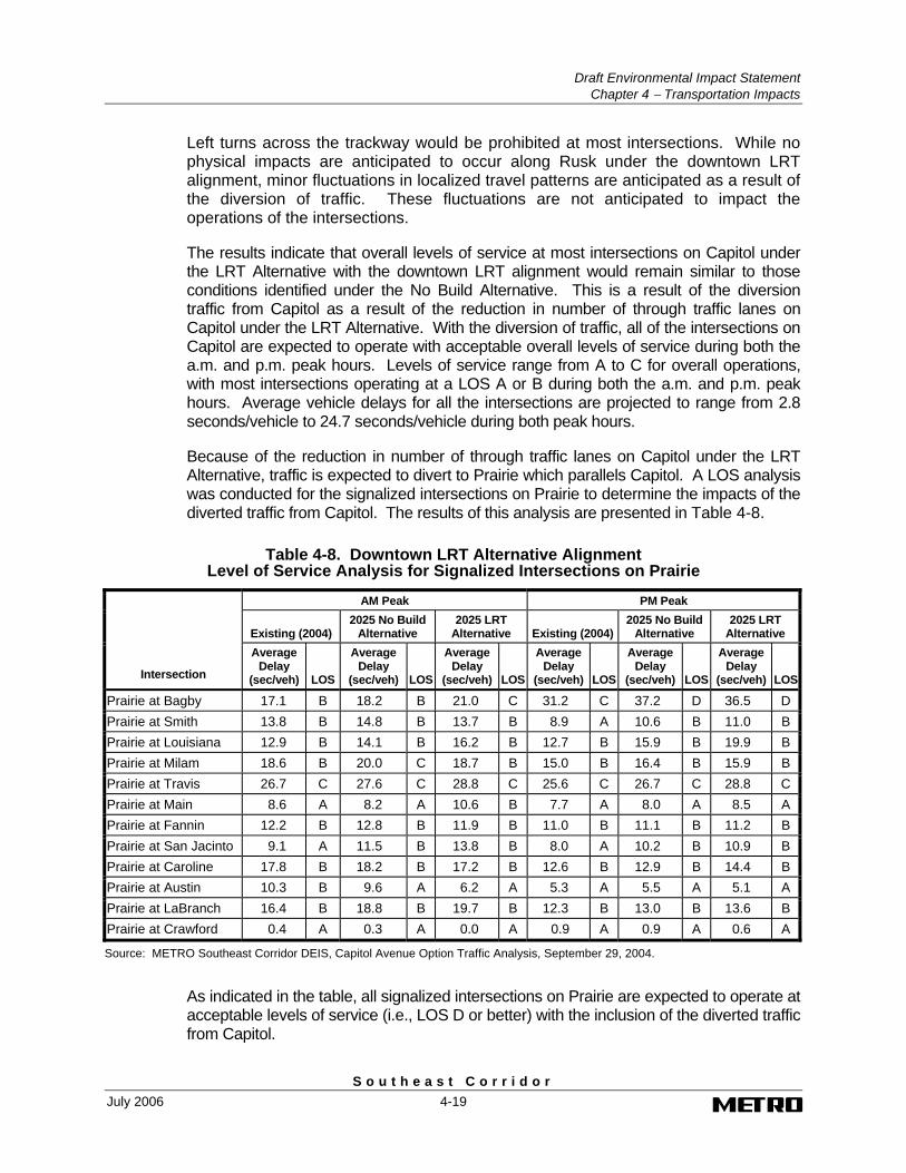
Because of the reduction in number of through traffic lanes on Capitol under the LRT Alternative, traffic is expected to divert to Prairie which parallels Capitol. A LOS analysis was conducted for the signalized intersections on Prairie to determine the impacts of the diverted traffic from Capitol. The results of this analysis are presented in Table 4-8.
Table 4-8. Downtown LRT Alternative Alignment Level of Service Analysis for Signalized Intersections on Prairie
AM Peak PM Peak
Existing (2004) 2025 No Build
Alternative 2025 LRT
Alternative Existing (2004)2025 No Build
Alternative 2025 LRT
Alternative
Intersection
Average Delay
(sec/veh) LOS
Average Delay
(sec/veh) LOS
Average Delay
(sec/veh) LOS
Average Delay
(sec/veh) LOS
Average Delay
(sec/veh) LOS
Average Delay
(sec/veh) LOS
Prairie at Bagby 17.1 B 18.2 B 21.0 C 31.2 C 37.2 D 36.5 D Prairie at Smith 13.8 B 14.8 B 13.7 B 8.9 A 10.6 B 11.0 B Prairie at Louisiana 12.9 B 14.1 B 16.2 B 12.7 B 15.9 B 19.9 B Prairie at Milam 18.6 B 20.0 C 18.7 B 15.0 B 16.4 B 15.9 B Prairie at Travis 26.7 C 27.6 C 28.8 C 25.6 C 26.7 C 28.8 C Prairie at Main 8.6 A 8.2 A 10.6 B 7.7 A 8.0 A 8.5 A Prairie at Fannin 12.2 B 12.8 B 11.9 B 11.0 B 11.1 B 11.2 B Prairie at San Jacinto 9.1 A 11.5 B 13.8 B 8.0 A 10.2 B 10.9 B Prairie at Caroline 17.8 B 18.2 B 17.2 B 12.6 B 12.9 B 14.4 B Prairie at Austin 10.3 B 9.6 A 6.2 A 5.3 A 5.5 A 5.1 A Prairie at LaBranch 16.4 B 18.8 B 19.7 B 12.3 B 13.0 B 13.6 B Prairie at Crawford 0.4 A 0.3 A 0.0 A 0.9 A 0.9 A 0.6 A
Source: METRO Southeast Corridor DEIS, Capitol Avenue Option Traffic Analysis, September 29, 2004.
As indicated in the table, all signalized intersections on Prairie are expected to operate at acceptable levels of service (i.e., LOS D or better) with the inclusion of the diverted traffic from Capitol.
Draft Environmental Impact Statement Chapter 4 − Transportation Impacts
S o u t h e a s t C o r r i d o r 4-20 July 2006
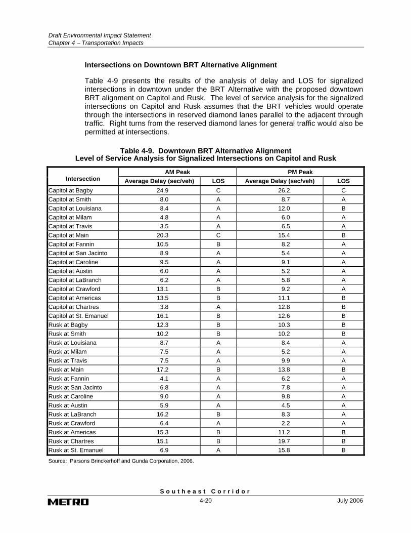
Intersections on Downtown BRT Alternative Alignment
Table 4-9 presents the results of the analysis of delay and LOS for signalized intersections in downtown under the BRT Alternative with the proposed downtown BRT alignment on Capitol and Rusk. The level of service analysis for the signalized intersections on Capitol and Rusk assumes that the BRT vehicles would operate through the intersections in reserved diamond lanes parallel to the adjacent through traffic. Right turns from the reserved diamond lanes for general traffic would also be permitted at intersections.
Table 4-9. Downtown BRT Alternative Alignment Level of Service Analysis for Signalized Intersections on Capitol and Rusk
AM Peak PM Peak Intersection Average Delay (sec/veh) LOS Average Delay (sec/veh) LOS
Capitol at Bagby 24.9 C 26.2 C Capitol at Smith 8.0 A 8.7 A Capitol at Louisiana 8.4 A 12.0 B Capitol at Milam 4.8 A 6.0 A Capitol at Travis 3.5 A 6.5 A Capitol at Main 20.3 C 15.4 B Capitol at Fannin 10.5 B 8.2 A Capitol at San Jacinto 8.9 A 5.4 A Capitol at Caroline 9.5 A 9.1 A Capitol at Austin 6.0 A 5.2 A Capitol at LaBranch 6.2 A 5.8 A Capitol at Crawford 13.1 B 9.2 A Capitol at Americas 13.5 B 11.1 B Capitol at Chartres 3.8 A 12.8 B Capitol at St. Emanuel 16.1 B 12.6 B Rusk at Bagby 12.3 B 10.3 B Rusk at Smith 10.2 B 10.2 B Rusk at Louisiana 8.7 A 8.4 A Rusk at Milam 7.5 A 5.2 A Rusk at Travis 7.5 A 9.9 A Rusk at Main 17.2 B 13.8 B Rusk at Fannin 4.1 A 6.2 A Rusk at San Jacinto 6.8 A 7.8 A Rusk at Caroline 9.0 A 9.8 A Rusk at Austin 5.9 A 4.5 A Rusk at LaBranch 16.2 B 8.3 A Rusk at Crawford 6.4 A 2.2 A Rusk at Americas 15.3 B 11.2 B Rusk at Chartres 15.1 B 19.7 B Rusk at St. Emanuel 6.9 A 15.8 B
Source: Parsons Brinckerhoff and Gunda Corporation, 2006.
Draft Environmental Impact Statement
Chapter 4 − Transportation Impacts
S o u t h e a s t C o r r i d o r July 2006 4-21
The results indicate that overall intersection levels of service at most intersections on Capitol and Rusk would remain similar to those conditions identified under the No Build Alternative. This is a result of the similar operations at intersections under the No Build and BRT alternatives.
All of the intersections on Capitol and Rusk are expected to operate with acceptable overall levels of service during both the a.m. and p.m. peak hours. Levels of service range from A to C for overall operations, with most intersections operating at a LOS A or B during both the a.m. and p.m. peak hours. Average vehicle delays for all the intersections are projected to range from 2.2 seconds/vehicle to 26.2 seconds/vehicle during both peak hours.
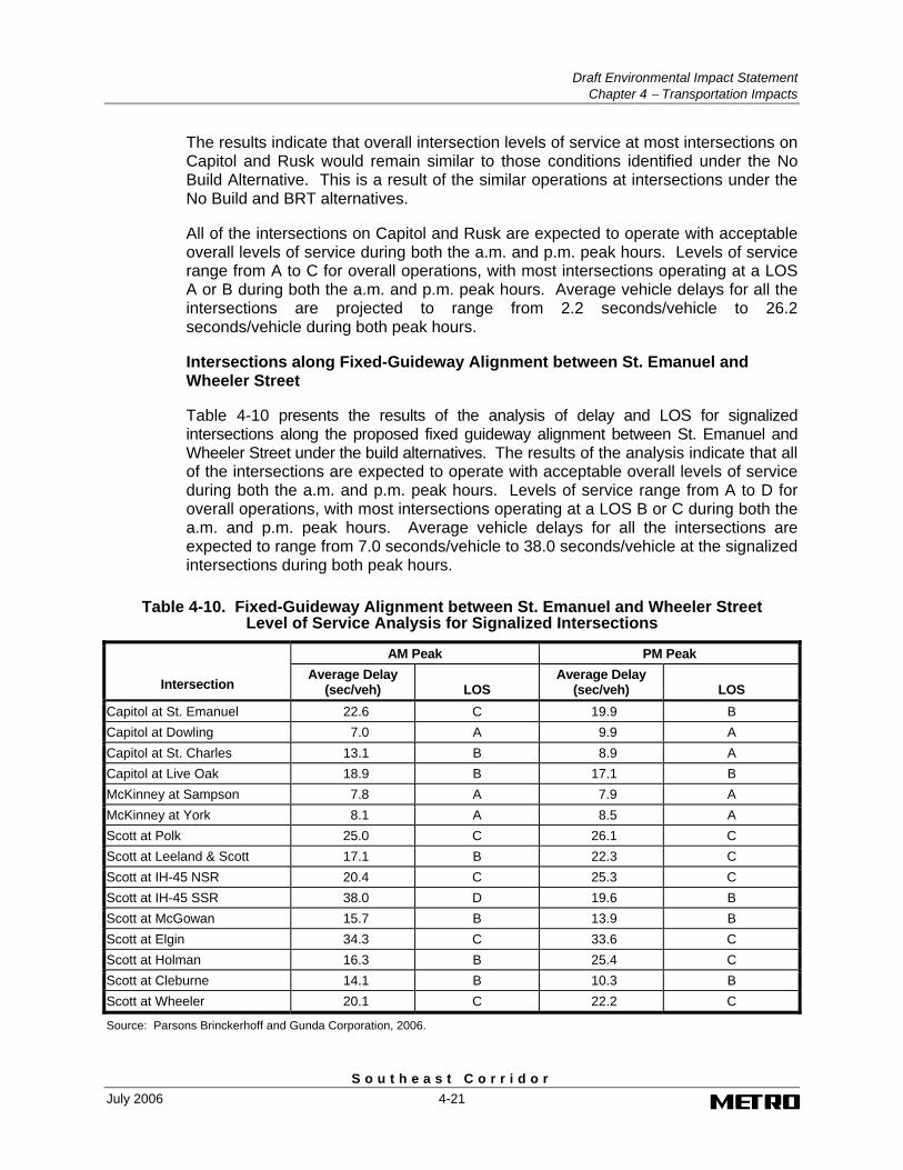
Intersections along Fixed-Guideway Alignment between St. Emanuel and Wheeler Street
Table 4-10 presents the results of the analysis of delay and LOS for signalized intersections along the proposed fixed guideway alignment between St. Emanuel and Wheeler Street under the build alternatives. The results of the analysis indicate that all of the intersections are expected to operate with acceptable overall levels of service during both the a.m. and p.m. peak hours. Levels of service range from A to D for overall operations, with most intersections operating at a LOS B or C during both the a.m. and p.m. peak hours. Average vehicle delays for all the intersections are expected to range from 7.0 seconds/vehicle to 38.0 seconds/vehicle at the signalized intersections during both peak hours.
Table 4-10. Fixed-Guideway Alignment between St. Emanuel and Wheeler Street Level of Service Analysis for Signalized Intersections
AM Peak PM Peak
Intersection Average Delay
(sec/veh) LOS Average Delay
(sec/veh) LOS Capitol at St. Emanuel 22.6 C 19.9 B Capitol at Dowling 7.0 A 9.9 A Capitol at St. Charles 13.1 B 8.9 A Capitol at Live Oak 18.9 B 17.1 B McKinney at Sampson 7.8 A 7.9 A McKinney at York 8.1 A 8.5 A Scott at Polk 25.0 C 26.1 C Scott at Leeland & Scott 17.1 B 22.3 C Scott at IH-45 NSR 20.4 C 25.3 C Scott at IH-45 SSR 38.0 D 19.6 B Scott at McGowan 15.7 B 13.9 B Scott at Elgin 34.3 C 33.6 C Scott at Holman 16.3 B 25.4 C Scott at Cleburne 14.1 B 10.3 B Scott at Wheeler 20.1 C 22.2 C
Source: Parsons Brinckerhoff and Gunda Corporation, 2006.
Draft Environmental Impact Statement Chapter 4 − Transportation Impacts
S o u t h e a s t C o r r i d o r 4-22 July 2006
Intersections along Fixed-Guideway Alignment between Wheeler Street and Beekman Road
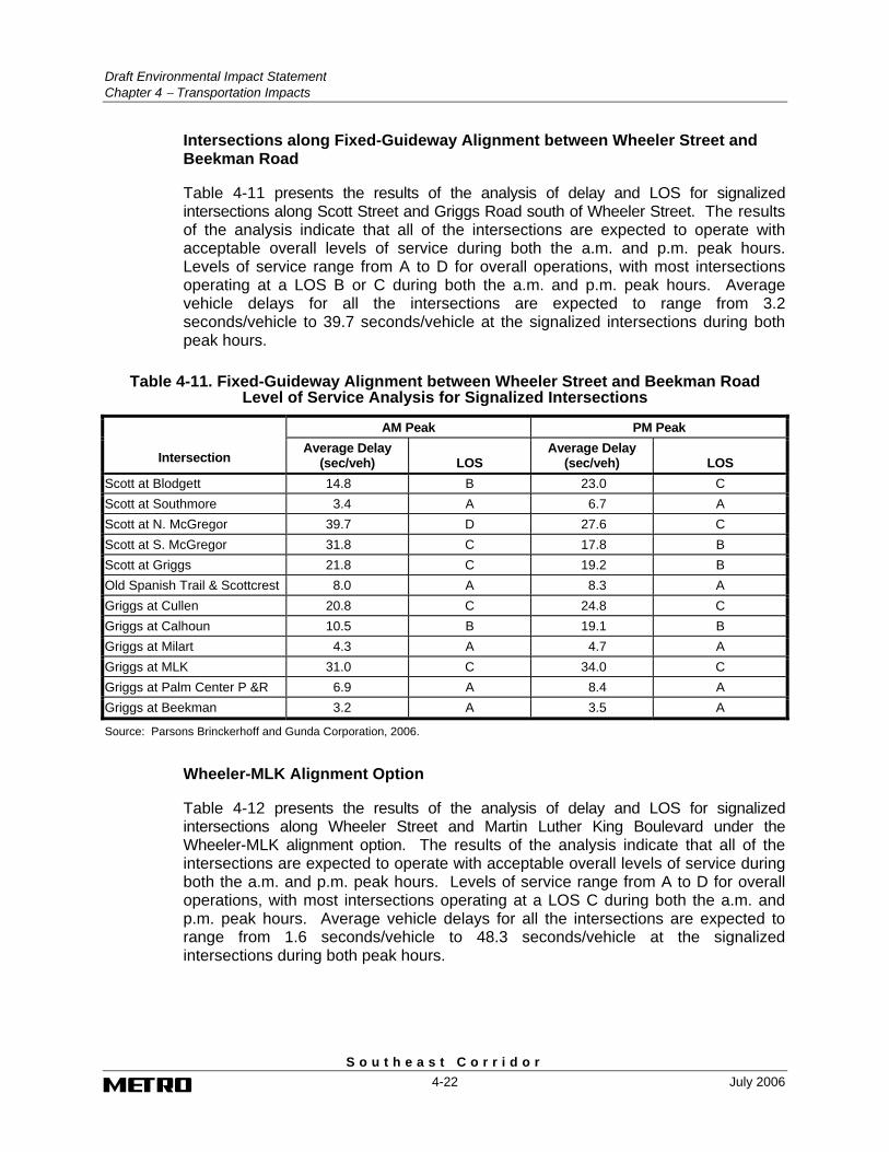
Table 4-11 presents the results of the analysis of delay and LOS for signalized intersections along Scott Street and Griggs Road south of Wheeler Street. The results of the analysis indicate that all of the intersections are expected to operate with acceptable overall levels of service during both the a.m. and p.m. peak hours. Levels of service range from A to D for overall operations, with most intersections operating at a LOS B or C during both the a.m. and p.m. peak hours. Average vehicle delays for all the intersections are expected to range from 3.2 seconds/vehicle to 39.7 seconds/vehicle at the signalized intersections during both peak hours.
Table 4-11. Fixed-Guideway Alignment between Wheeler Street and Beekman Road Level of Service Analysis for Signalized Intersections
AM Peak PM Peak
Intersection Average Delay
(sec/veh) LOS Average Delay
(sec/veh) LOS Scott at Blodgett 14.8 B 23.0 C Scott at Southmore 3.4 A 6.7 A Scott at N. McGregor 39.7 D 27.6 C Scott at S. McGregor 31.8 C 17.8 B Scott at Griggs 21.8 C 19.2 B Old Spanish Trail & Scottcrest 8.0 A 8.3 A Griggs at Cullen 20.8 C 24.8 C Griggs at Calhoun 10.5 B 19.1 B Griggs at Milart 4.3 A 4.7 A Griggs at MLK 31.0 C 34.0 C Griggs at Palm Center P &R 6.9 A 8.4 A Griggs at Beekman 3.2 A 3.5 A
Source: Parsons Brinckerhoff and Gunda Corporation, 2006.
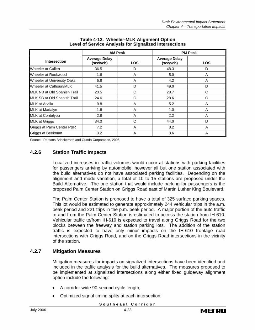
Wheeler-MLK Alignment Option
Table 4-12 presents the results of the analysis of delay and LOS for signalized intersections along Wheeler Street and Martin Luther King Boulevard under the Wheeler-MLK alignment option. The results of the analysis indicate that all of the intersections are expected to operate with acceptable overall levels of service during both the a.m. and p.m. peak hours. Levels of service range from A to D for overall operations, with most intersections operating at a LOS C during both the a.m. and p.m. peak hours. Average vehicle delays for all the intersections are expected to range from 1.6 seconds/vehicle to 48.3 seconds/vehicle at the signalized intersections during both peak hours.
Draft Environmental Impact Statement
Chapter 4 − Transportation Impacts
S o u t h e a s t C o r r i d o r July 2006 4-23
Table 4-12. Wheeler-MLK Alignment Option Level of Service Analysis for Signalized Intersections
AM Peak PM Peak
Intersection Average Delay
(sec/veh) LOS Average Delay
(sec/veh) LOS Wheeler at Cullen 36.5 D 48.3 D Wheeler at Rockwood 1.6 A 5.0 A Wheeler at University Oaks 5.8 A 4.2 A Wheeler at Calhoun/MLK 41.5 D 49.0 D MLK NB at Old Spanish Trail 23.5 C 28.7 C MLK SB at Old Spanish Trail 24.6 C 28.6 C MLK at Arvilla 9.8 A 5.2 A MLK at Madalyn 1.6 A 1.0 A MLK at Contelyou 2.8 A 2.2 A MLK at Griggs 34.0 C 44.0 D Griggs at Palm Center P&R 7.2 A 8.2 A Griggs at Beekman 3.2 A 3.6 A
Source: Parsons Brinckerhoff and Gunda Corporation, 2006.
4.2.6 Station Traffic Impacts
Localized increases in traffic volumes would occur at stations with parking facilities for passengers arriving by automobile; however all but one station associated with the build alternatives do not have associated parking facilities. Depending on the alignment and mode variation, a total of 10 to 15 stations are proposed under the Build Alternative. The one station that would include parking for passengers is the proposed Palm Center Station on Griggs Road east of Martin Luther King Boulevard.
The Palm Center Station is proposed to have a total of 325 surface parking spaces. This lot would be estimated to generate approximately 244 vehicular trips in the a.m. peak period and 221 trips in the p.m. peak period. A major portion of the auto traffic to and from the Palm Center Station is estimated to access the station from IH-610. Vehicular traffic to/from IH-610 is expected to travel along Griggs Road for the two blocks between the freeway and station parking lots. The addition of the station traffic is expected to have only minor impacts on the IH-610 frontage road intersections with Griggs Road, and on the Griggs Road intersections in the vicinity of the station.
4.2.7 Mitigation Measures
Mitigation measures for impacts on signalized intersections have been identified and included in the traffic analysis for the build alternatives. The measures proposed to be implemented at signalized intersections along either fixed guideway alignment option include the following:
• A corridor-wide 90-second cycle length;
• Optimized signal timing splits at each intersection;

Draft Environmental Impact Statement Chapter 4 − Transportation Impacts
S o u t h e a s t C o r r i d o r 4-24 July 2006
• A corridor-wide interconnected coordinated traffic signal system;
• New traffic signal controllers at each signalized intersection;
• Traffic signal phasing operations with a special fixed guideway vehicle phase; and
• Protected left turn phases for traffic turning across the fixed guideway from parallel lanes.
4.3 Impacts on Railroads
Under the build alternatives, a short section of non-operational railroad tracks along Walker near Ennis would be eliminated. Because the tracks along Walker are currently non-operational, the removal of the tracks is not expected to impact the operations of the railroad or service to customers of the railroad. Additionally, the build alternatives would end east of Martin Luther King Boulevard on Griggs Road and would not have any impact to the existing at-grade railroad crossing of the Union Pacific Railroad (UPRR) and BNSF railroads near the intersection of Griggs Road and Long Drive.
4.4 On-Street Parking Impacts
4.4.1 Downtown LRT Alternative Alignment
In the downtown area, all curb loading zones and on-street parking along Capitol would be eliminated under the LRT Alternative. The reduction in the number of travel lanes along Capitol and the location of the LRT trackway along the south curb from Travis to the east would require the elimination of loading and parking zones to reduce interference with the through traffic lanes. The elimination of the on-street parking along Capitol would eliminate the existing parking meters and associated revenue from the existing parking space utilization. Existing parking garage access and loading dock driveways connecting to Capitol would need to be accommodated across the LRT trackway in areas where the adjacent travel lane has been eliminated.
4.4.2 Downtown BRT Alternative Alignment
In the downtown area, all curb loading zones and on-street parking along the north curb of Capitol and the south curb along Rusk would be eliminated under the BRT Alternative. The elimination of curb-side parking and loading zones along the identified side of each roadway is required for the inclusion of the BRT reserved diamond lanes. The elimination of the on-street parking along the north curb on Capitol and the south curb on Rusk would eliminate the existing parking meters and associated revenue from the existing parking space utilization. Access to existing parking garage access and loading dock driveways would be maintained since general traffic turning vehicles will be able to utilize the BRT reserved diamond lane for right turns. Vehicles exiting from existing parking garage structures will be able to turn across the BRT reserved diamond lane to enter the roadway.
Draft Environmental Impact Statement
Chapter 4 − Transportation Impacts
S o u t h e a s t C o r r i d o r July 2006 4-25
4.4.3 Fixed Guideway Alignment between St. Emanuel and Wheeler Street
As previously noted, there is generally no on-street parking permitted along Scott Street. In the areas with on-street parking, the parking is limited to non-peak hours due to the use of the existing curb lane along Scott Street for peak period travel. As a result of this limitation, daytime and overnight parking use along Scott Street is generally low. The impacts to on-street parking as a result of the location of the fixed guideway alignment along Scott Street between St. Emanuel Street and Wheeler Street under the build alternatives are expected to be minimal. One area of minor impact will be the section of Scott Street from south of the IH-45 to Rosalie Street where non-peak parking is available between the 2300 and 3000 blocks, along both sides of the roadway. A field review of the parking utilization indicates little use of the parking spaces during daytime hours (Gunda, 2004). Therefore, the impact of the reduction of parking in this area is expected to be minimal.
4.4.4 Fixed-Guideway Alignment between Wheeler Street and Beekman Road
There is generally no on-street parking permitted along Scott Street south of the Wheeler Street intersection. In the areas with on-street parking, the parking is limited to non-peak hours due to the use of the existing curb lane along Scott Street for peak period travel. As a result of this limitation, daytime and overnight parking use along Scott Street is low. The impacts to on-street parking as a result of the location of the fixed-guideway alignment along Scott Street under the Southeast Transit Center alignment option under the build alternatives are expected to be minimal.
Along Griggs Road from Cullen Boulevard to Long Drive, there are currently no signs for parking restrictions along either side of the roadway. The location of the fixed guideway alignment along Griggs Road through this area would require the elimination of all existing on-street parking and loading zones. Access to driveways along the roadway, however, would not be impacted because of the location of the fixed guideway in the median of the roadway.
4.4.5 Wheeler-MLK Alignment Option
Along Wheeler Street from Scott Street to Martin Luther King Boulevard, there is no on-street parking permitted along either side of the roadway. One section of non-daytime on-street parking is located between Scott Street and Cullen Boulevard. Due to this restriction and the lack of adjacent supporting land uses, the use of this parking during the evening hours is limited and any impacts from the inclusion of the fixed guideway along the roadway would be minimal.
Along Martin Luther King Boulevard between Wheeler Street and Old Spanish Trail no on-street parking is currently permitted and as a result, the inclusion of the fixed guideway along the roadway would not alter this on-street parking restriction in this section.
Draft Environmental Impact Statement Chapter 4 − Transportation Impacts
S o u t h e a s t C o r r i d o r 4-26 July 2006
4.5 Impacts on Bicycle and Pedestrian Facilities
Impacts to bicycle and pedestrian facilities would be minor and limited to perpendicular crossings at existing roadway intersections. The Build Alternative would not introduce any new barriers along the proposed alignment. There would be no impact to the signed, shared-lane bicycle routes on Wheeler Street, between Scott and Cullen Road, and on Griggs Road, from Scott Street to Mykawa Road, because in both locations sufficient right of way would be available or obtained to preserve the existing number of traffic lanes, while the fixed guideway would be added as exclusive transit lanes.