Chapter 3 TRANSPORTATION IMPACTS AND...
66
Final Environmental Impact Statement/ Page 3-1 Environmental Impact Report Chapter 3 TRANSPORTATION IMPACTS AND MITIGATION This chapter summarizes the existing traffic circulation, transit, parking, pedestrian, and bicycle transportation conditions in the project area, and the potential impacts of the proposed alternatives, including the LPA. The environmental analysis assumes a conservative, worst-case, condition when determining potential impacts. The information in this chapter is based on the Transportation Technical Memorandum, which is incorporated into this EIS/EIR as Appendix L. Section 4.18 summarizes construction impacts from Chapter 3 and other sections of Chapter 4. The construction impact analysis and findings are given in full detail in this chapter, and are included in the summary in Section 4.18. The analysis of all transportation impacts associated with the Locally Preferred Alternative (LPA) is detailed below in Section 3.3.5. This chapter has been updated since publication of the Draft EIS/EIR to address comments received on the Draft EIS/EIR, as indicated in the Responses to Comments, Volumes F-2 and F-3, of this Final EIS/EIR, and based on refinements to the LPA. A vertical line in the margin is used to show where revisions have occurred to this chapter since publication of the Draft EIS/EIR, excluding minor edits for consistency and correction of formatting and minor typographical errors. Since designation of an LPA, mitigation measures have been refined and confirmed for the LPA, which are listed in Section 3.4.2 below, based on input received during the Draft EIS/EIR public review period. No changes to the National Environmental Policy Act (NEPA) impact findings or California Environmental Quality Act (CEQA) impact determinations were identified as a result of refinements to the LPA, responses to comments, or other developments since publication of the Draft EIS/EIR. Mitigation measures listed for the LPA in this chapter have been carried forward and included in the Mitigation Monitoring and Reporting Program (MMRP) for the LPA, Chapter 8, of this Final EIS/EIR. 3.1 Regulatory Framework For this transportation impact analysis, CDM reviewed guidelines obtained from CEQA, NEPA, and the Los Angeles Department of Transportation (LADOT), in addition to the City of Los Angeles General Plan’s Circulation Element. CEQA guidelines define “significant effect” or “significant impact” as a substantial, or potentially substantial, adverse change in any of the physical conditions within the area affected by the project. The determination of whether a project may have a significant effect on the environment calls for careful judgment on the part of the public agency involved, based to the extent possible on scientific and factual data. There are few quantitative standards of significance related to transportation effects. The measurement and prediction of level of service (LOS) at potentially affected intersections is a standard that is used to evaluate the significance of potential traffic impacts. Predicted changes in level of service provide indications of how well road-based movements may function under the different alternatives, which may have implications for vehicular traffic, and certain types of transit and non-motorized transportation. Senate Bill 375 (SB 375) requires the California Air Resources Board (CARB) to set regional targets for 2020 and 2035 to reduce greenhouse gas (GHG) emissions from passenger vehicles. A regional target has been developed for each of the 18 metropolitan planning organizations
Transcript of Chapter 3 TRANSPORTATION IMPACTS AND...
Final Environmental Impact Statement/ Page 3-1 Environmental Impact Report
Chapter 3 TRANSPORTATION IMPACTS AND MITIGATION
This chapter summarizes the existing traffic circulation, transit, parking, pedestrian, and bicycle transportation conditions in the project area, and the potential impacts of the proposed alternatives, including the LPA. The environmental analysis assumes a conservative, worst-case, condition when determining potential impacts. The information in this chapter is based on the Transportation Technical Memorandum, which is incorporated into this EIS/EIR as Appendix L. Section 4.18 summarizes construction impacts from Chapter 3 and other sections of Chapter 4. The construction impact analysis and findings are given in full detail in this chapter, and are included in the summary in Section 4.18. The analysis of all transportation impacts associated with the Locally Preferred Alternative (LPA) is detailed below in Section 3.3.5.
This chapter has been updated since publication of the Draft EIS/EIR to address comments received on the Draft EIS/EIR, as indicated in the Responses to Comments, Volumes F-2 and F-3, of this Final EIS/EIR, and based on refinements to the LPA. A vertical line in the margin is used to show where revisions have occurred to this chapter since publication of the Draft EIS/EIR, excluding minor edits for consistency and correction of formatting and minor typographical errors. Since designation of an LPA, mitigation measures have been refined and confirmed for the LPA, which are listed in Section 3.4.2 below, based on input received during the Draft EIS/EIR public review period. No changes to the National Environmental Policy Act (NEPA) impact findings or California Environmental Quality Act (CEQA) impact determinations were identified as a result of refinements to the LPA, responses to comments, or other developments since publication of the Draft EIS/EIR. Mitigation measures listed for the LPA in this chapter have been carried forward and included in the Mitigation Monitoring and Reporting Program (MMRP) for the LPA, Chapter 8, of this Final EIS/EIR.
3.1 Regulatory Framework For this transportation impact analysis, CDM reviewed guidelines obtained from CEQA, NEPA, and the Los Angeles Department of Transportation (LADOT), in addition to the City of Los Angeles General Plan’s Circulation Element. CEQA guidelines define “significant effect” or “significant impact” as a substantial, or potentially substantial, adverse change in any of the physical conditions within the area affected by the project. The determination of whether a project may have a significant effect on the environment calls for careful judgment on the part of the public agency involved, based to the extent possible on scientific and factual data. There are few quantitative standards of significance related to transportation effects. The measurement and prediction of level of service (LOS) at potentially affected intersections is a standard that is used to evaluate the significance of potential traffic impacts. Predicted changes in level of service provide indications of how well road-based movements may function under the different alternatives, which may have implications for vehicular traffic, and certain types of transit and non-motorized transportation.
Senate Bill 375 (SB 375) requires the California Air Resources Board (CARB) to set regional targets for 2020 and 2035 to reduce greenhouse gas (GHG) emissions from passenger vehicles. A regional target has been developed for each of the 18 metropolitan planning organizations

Chapter 3 Transportation Impacts and Mitigation
Page 3-2 Regional Connector Transit Corridor
(MPOs) in the state; the Southern California Association of Governments (SCAG) is the MPO that would have jurisdiction over the Regional Connector Transit Corridor project area. Each MPO is required to develop “Sustainable Community Strategies” (SCS) through integrated land use and transportation planning and to demonstrate an ability to attain the adopted reduction targets by 2020 and 2035. Prior to adoption of the target, SCAG proceeded with the SCS process on the tentative assumption that the region will have an approximate reduction target of 2.5 million metric tons of carbon dioxide equivalent (MMTCO2e) for 2020 (SCAG 2009). This target is based on the fact that the statewide reduction target is 5 MMTCO2e, and the SCAG region accounts for roughly half of the state’s population and emissions.
The travel forecasting model was developed by Metro and is based on SCAG’s Regional Travel Demand Model. The travel demand forecast model includes the approved land use and financially constrained future highway and transit network for 2035. The model estimates future travel demand based on several input criteria, including the following:
SCAG forecasts of population and employment growth
SCAG forecasted changes in the socio-demographic characteristics of travelers
Future characteristics of the roadway and transit systems, including travel times, costs, and capacity reflective of the No Build, TSM, and build alternatives (including the LPA)
To represent the affected environment from a traffic operations perspective, 192 intersections in the project area were analyzed. The intersections are located near potential rail stations along the proposed project alignment and at intersections of major arterials in the project area. The jurisdictions affected by the project were consulted throughout the scoping process and assisted in the selection of study intersections. Detailed a.m. and p.m. peak period intersection turning movement counts were conducted in 2008 and 2009 to represent existing traffic volumes on a typical weekday throughout the project area.
3.1.1 Transit Existing transit services within the project area that parallel the Regional Connector alignment were identified and tabulated to show destinations, existing headways, service characteristics, and operating time periods. No NEPA, CEQA, or local thresholds are available for determining the significance of impacts to transit service. Changes to the transit network are described for each alternative in Section 3.3. This section analyzes transit impacts and benefits for each alternative by examining changes in transit performance. Transit performance includes travel speeds and times, transit service reliability, transit ridership, and passenger comfort and convenience. Evaluation criteria included:
Transit travel times,
Speed and reliability,
Transit ridership, and
Passenger comfort and convenience.
Transportation Impacts Chapter 3 and Mitigation
Final Environmental Impact Statement/ Page 3-3 Environmental Impact Report
3.1.2 Traffic Circulation Significant impacts generated by the build alternatives, including the LPA, were identified by comparing results of the LOS analyses. Each future build alternative evaluated was compared to the No Build Alternative to provide an analysis of impacts at project operation. A comparison of the project to existing conditions is provided in Chapter 10 of this Final EIS/EIR. The reason for this comparison is to determine potential significant impacts due to the proposed project. The threshold of significance used to identify significant traffic impacts under both NEPA and CEQA are based on revised guidelines set forth by LADOT in the LADOT Traffic Study Policies and Procedures (March 2002). The significance threshold at an intersection is based on the amount of change in overall delay between an action alternative and the No Build Alternative. Change in delay is classified using LOS, which is defined in Table 3-1 using the average vehicle delay (the length of delay caused by traffic congestion at a given intersection).
Traffic circulation impacts are evaluated based on the additional average vehicle delay that a proposed alternative would cause beyond the No Build Alternative conditions. Table 3-2 presents the applicable thresholds for this evaluation. For example, an alternative would have a significant impact at an intersection with existing LOS C if it adds 6.0 or more seconds of delay. If an intersection continues to operate at LOS A or B after implementation of an alternative, then the alternative is considered to have no substantial adverse impact on that intersection.
More information about the methodology used for traffic circulation impact evaluation is available in the Transportation Technical Memorandum (Appendix L).
Table 3-1. Level of Service Definitions for Signalized Intersections
LOS Average Vehicle Delay
(in seconds) Definition
A < 10.0 EXCELLENT. No vehicle waits longer than one red light and no approach phase are fully used.
B > 10.0 and < 20.0 VERY GOOD. An occasional approach phase is fully utilized; many drivers begin to feel somewhat restricted within groups of vehicles.
C > 20.0 and < 35.0 GOOD. Occasionally drivers may have to wait through more than one red light; backups may develop behind turning vehicles.
D > 35.0 and < 55.0 FAIR. Delays may be substantial during portions of the rush hours, but enough lower volume periods occur to permit clearing of developing lines, preventing excessive backups.
E > 55.0 and < 80.0 POOR. Represents the most vehicles intersection approaches can accommodate; may be long lines of waiting vehicles through several signal cycles.
F > 80.0
FAILURE. Backups from nearby locations or on cross streets may restrict or prevent movement of vehicles out of the intersection approaches. Tremendous delays with continuously increasing queue lengths.
Chapter 3 Transportation Impacts and Mitigation
Page 3-4 Regional Connector Transit Corridor
Table 3-2. Intersection Significance Thresholds
Final Intersection LOS with Project Change in Delay (in seconds) from the No Build Alternative
LOS A -----
LOS B -----
LOS C 6.0
LOS D 4.0
LOS E 2.5
LOS F 2.5
3.1.3 Parking An on-street parking evaluation was conducted to assess the number of spaces that may be removed due to each one of the alternatives, including the LPA. The analysis included a field inventory of the number of available on-street parking and loading spaces and identification of peak period parking restrictions, if applicable. No NEPA, CEQA, or local thresholds are available to guide the determination of the significance of impacts to parking. Reductions in parking are described for each alternative in Section 3.3. Evaluation of potential parking impacts included consideration of:
The availability of parking within one-half mile walking distance; and
The availability of loading zones in relation to the location of commercial enterprises.
Refer to Section 4.2, Displacement and Relocation, for analysis of off-street parking impacts.
3.1.4 Other Modes Bicycle and pedestrian circulation was evaluated as part of this transportation analysis. No NEPA, CEQA, or local thresholds are available to guide the determination of significance of impacts to bicycle and pedestrian circulations. Changes to the bicycle and pedestrian network are described for each alternative in Section 3.3. Evaluation of potential impacts to bicycle and pedestrian circulation included consideration of:
Detours that might lengthen bicycle commutes or pedestrian routes (which would increase travel time); and
Safety of alternate routes.

Transportation Impacts Chapter 3 and Mitigation
Final Environmental Impact Statement/ Page 3-5 Environmental Impact Report
3.2 Affected Environment This section identifies the existing conditions being evaluated for each transportation component. The transportation environment consists of transit, traffic circulation, parking, and other modes (e.g., pedestrians and bicycles).
3.2.1 Transit The Regional Connector Transit Corridor is located within the central business district of downtown Los Angeles, which is characterized by the highest concentration of transit service in the county. Ten transit operators operate approximately 110 bus routes throughout the project area. In addition, Metro operates four rail transit lines, and an additional line is currently under construction. Transit services in the downtown area vary considerably in speed, frequency, and capacity.
The transit operators include:
Antelope Valley Transit Authority (AVTA)
City of Gardena
City of Santa Clarita
City of Santa Monica (Big Blue Bus)
Foothill Transit
LADOT
Metro
Montebello Bus Lines
Orange County Transportation Authority (OCTA)
Torrance Transit
The type of service provided by transit includes:
Traditional line-haul bus service
Peak-hour freeway express buses
Downtown circulator shuttles
Light rail
Heavy rail
Chapter 3 Transportation Impacts and Mitigation
Page 3-6 Regional Connector Transit Corridor
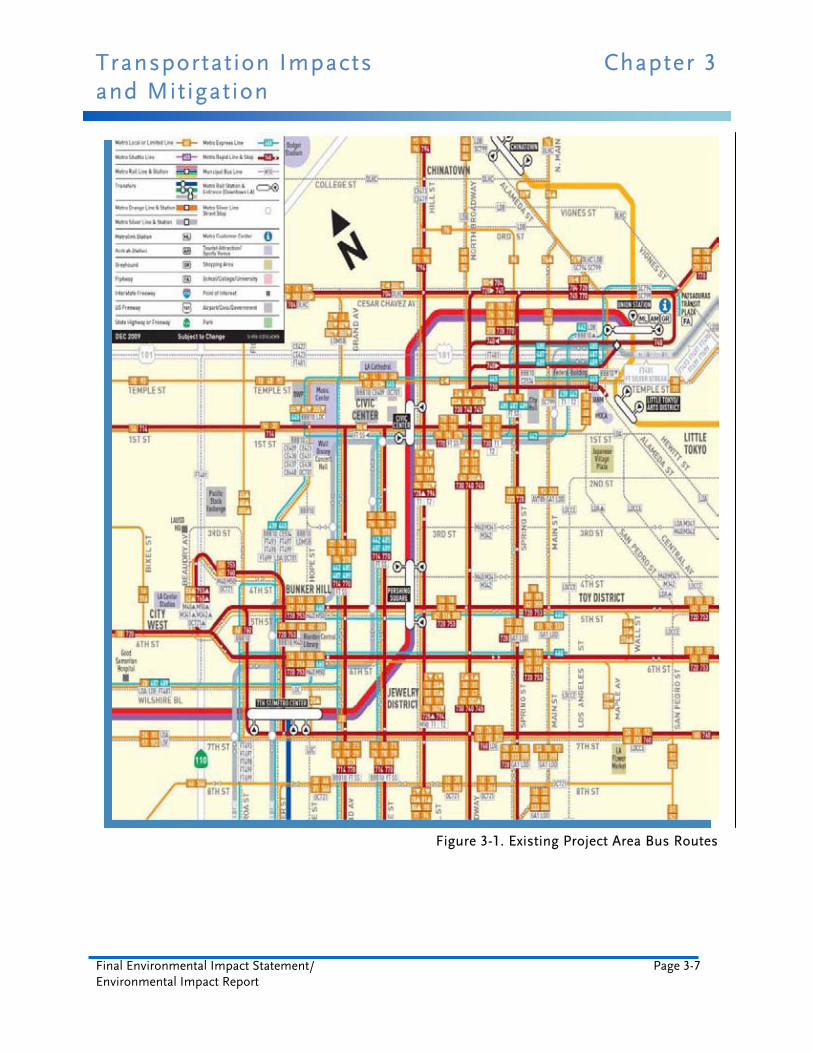
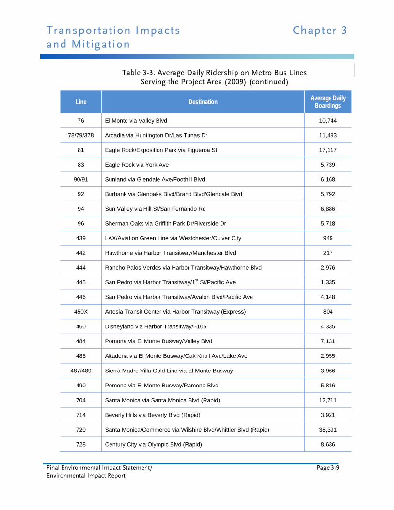
Existing project area bus routes and ridership are shown in Figure 3-1 and Table 3-3.
Although Metro and LADOT carry the majority of passengers, other operators provide peak-hour, peak-direction commuter bus service as well. In addition to public transit services, several high-rise office tenants also offer shuttle bus service to Union Station for their employees.
Commuter rail service to downtown Los Angeles is provided primarily by Metrolink and Amtrak, with connections to Metro Rail service at Union Station, which is located 0.1 mile outside of the project area analyzed for transportation impacts. Most passengers arriving at Union Station on Metrolink are bound for the central business district and presently use the Metro Red or Purple Line, LADOT DASH buses, or employer-provided shuttles to complete their trips.
Almost all streets in the downtown area are served during the peak hours, with bus service that has five minute or higher frequency (headways). The bus service runs in a grid pattern with the predominant flow of passengers being in an east-west orientation, although heavily utilized bus lines also run in the north-south direction. The most heavily-served streets are 1st Street, the 4th Street/5th Street couplet, Hill Street, Broadway, the Main Street/Spring Street couplet, and the Grand Street/Olive Street couplet.
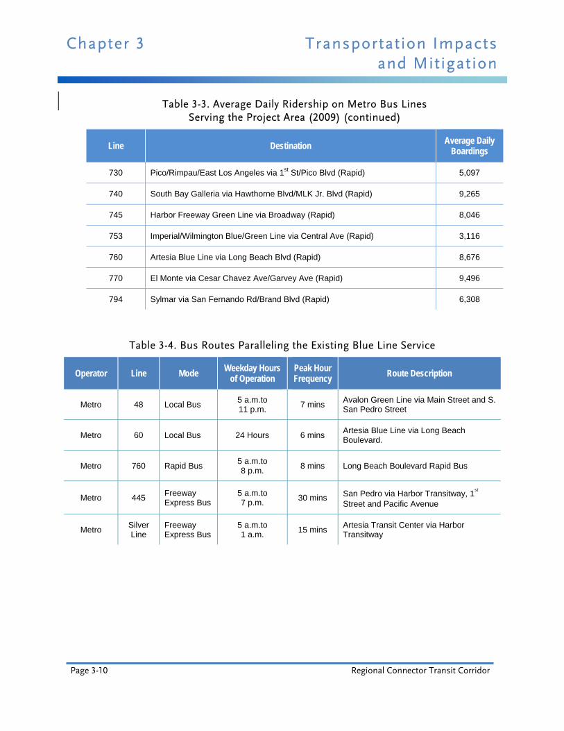
Major bus routes paralleling the Metro LRT lines and providing connections between the project area and the region are shown in the following tables. Each table shows the limits of a bus routes’ service, the operating period, and the peak-hour frequency. Tables 3-4 and 3-5 summarize the bus routes paralleling the Metro Gold Line to Pasadena (eventually Montclair) and the Metro Blue Line to Long Beach. These routes cover approximate portions of the proposed North-South Line.
Transportation Impacts Chapter 3 and Mitigation
Final Environmental Impact Statement/ Page 3-7 Environmental Impact Report
Figure 3-1. Existing Project Area Bus Routes

Chapter 3 Transportation Impacts and Mitigation
Page 3-8 Regional Connector Transit Corridor
Table 3-3. Average Daily Ridership on Metro Bus Lines Serving the Project Area (2009)
Line Destination Average Daily
Boardings
2/302 Pacific Palisades via Sunset Blvd 21,874
4 West Los Angeles/Santa Monica via Santa Monica Blvd 20,870
10 West Hollywood via Temple St/Melrose Ave 13,513
14/37 Beverly Hills via Beverly Blvd, Washington/Fairfax via Adams Blvd 16,908
16/316 Century City via 3rd St 26,732
18 Wilshire Center/Montebello via 6th St./Whittier Blvd 26,971
20 Westwood/Santa Monica via Wilshire Blvd 17,751
26/51/52/352 Hollywood/Compton/Artesia Transit Center via Avalon Blvd 27,632
28 Century City via Olympic Blvd 9,360
30 Pico/Rimpau Transit Center/Monterey Park via Pico Blvd/E 1st St 16,666
33/333 Santa Monica via Venice Blvd 23,205
35/335 Washington/Fairfax via Washington Blvd 9,104
38 Washington/Fairfax via Jefferson Blvd 5,984
40 South Bay Galleria via Hawthorne Blvd/MLK Jr. Blvd 17,714
42/42A LAX via La Tijera Blvd/MLK Jr. Blvd 4,904
45 Lincoln Heights/Rosewood via Broadway 20,972
53 Avalon Green Line via Main St/San Pedro St 10,590
55/355 Imperial/Wilmington Blue/Green Line via Compton Ave 10,443
60 Artesia Blue Line via Long Beach Blvd 17,626
62 Hawaiian Gardens via Telegraph Rd 4,331
66/366 Wilshire Center/Montebello via 8th St/Olympic Blvd 23,326
68/84 Monterey Park via Eagle Rock Blvd/Cypress Ave/Cesar Chavez Ave 9,513
70/71 Cal State Los Angeles/El Monte via Marengo St/Garvey Ave 13,521
Transportation Impacts Chapter 3 and Mitigation
Final Environmental Impact Statement/ Page 3-9 Environmental Impact Report
Table 3-3. Average Daily Ridership on Metro Bus Lines Serving the Project Area (2009) (continued)
Line Destination Average Daily
Boardings
76 El Monte via Valley Blvd 10,744
78/79/378 Arcadia via Huntington Dr/Las Tunas Dr 11,493
81 Eagle Rock/Exposition Park via Figueroa St 17,117
83 Eagle Rock via York Ave 5,739
90/91 Sunland via Glendale Ave/Foothill Blvd 6,168
92 Burbank via Glenoaks Blvd/Brand Blvd/Glendale Blvd 5,792
94 Sun Valley via Hill St/San Fernando Rd 6,886
96 Sherman Oaks via Griffith Park Dr/Riverside Dr 5,718
439 LAX/Aviation Green Line via Westchester/Culver City 949
442 Hawthorne via Harbor Transitway/Manchester Blvd 217
444 Rancho Palos Verdes via Harbor Transitway/Hawthorne Blvd 2,976
445 San Pedro via Harbor Transitway/1st St/Pacific Ave 1,335
446 San Pedro via Harbor Transitway/Avalon Blvd/Pacific Ave 4,148
450X Artesia Transit Center via Harbor Transitway (Express) 804
460 Disneyland via Harbor Transitway/I-105 4,335
484 Pomona via El Monte Busway/Valley Blvd 7,131
485 Altadena via El Monte Busway/Oak Knoll Ave/Lake Ave 2,955
487/489 Sierra Madre Villa Gold Line via El Monte Busway 3,966
490 Pomona via El Monte Busway/Ramona Blvd 5,816
704 Santa Monica via Santa Monica Blvd (Rapid) 12,711
714 Beverly Hills via Beverly Blvd (Rapid) 3,921
720 Santa Monica/Commerce via Wilshire Blvd/Whittier Blvd (Rapid) 38,391
728 Century City via Olympic Blvd (Rapid) 8,636
Chapter 3 Transportation Impacts and Mitigation
Page 3-10 Regional Connector Transit Corridor
Table 3-3. Average Daily Ridership on Metro Bus Lines Serving the Project Area (2009) (continued)
Line Destination Average Daily
Boardings
730 Pico/Rimpau/East Los Angeles via 1st St/Pico Blvd (Rapid) 5,097
740 South Bay Galleria via Hawthorne Blvd/MLK Jr. Blvd (Rapid) 9,265
745 Harbor Freeway Green Line via Broadway (Rapid) 8,046
753 Imperial/Wilmington Blue/Green Line via Central Ave (Rapid) 3,116
760 Artesia Blue Line via Long Beach Blvd (Rapid) 8,676
770 El Monte via Cesar Chavez Ave/Garvey Ave (Rapid) 9,496
794 Sylmar via San Fernando Rd/Brand Blvd (Rapid) 6,308
Table 3-4. Bus Routes Paralleling the Existing Blue Line Service
Operator Line Mode Weekday Hours
of Operation Peak Hour Frequency Route Description
Metro 48 Local Bus 5 a.m.to 11 p.m.
7 mins Avalon Green Line via Main Street and S. San Pedro Street
Metro 60 Local Bus 24 Hours 6 mins Artesia Blue Line via Long Beach Boulevard.
Metro 760 Rapid Bus 5 a.m.to 8 p.m.
8 mins Long Beach Boulevard Rapid Bus
Metro 445 Freeway Express Bus
5 a.m.to 7 p.m.
30 mins San Pedro via Harbor Transitway, 1st
Street and Pacific Avenue
Metro Silver Line
Freeway Express Bus
5 a.m.to 1 a.m.
15 mins Artesia Transit Center via Harbor Transitway

Transportation Impacts Chapter 3 and Mitigation
Final Environmental Impact Statement/ Page 3-11 Environmental Impact Report
Table 3-5. Bus Routes Paralleling the Existing Pasadena Gold Line Service
Operator Line Mode Weekday Hours
of Operation Peak Hour Frequency Route Description
Metro 78/79/ 378
Local/ Limited Stop Bus
5 a.m.to 1 a.m.
10 mins Arcadia via Huntington Drive and Las Tunas Drive
Metro 94 Local/ Limited Stop Bus
5 a.m.to 1 a.m.
5 mins Sylmar via San Fernando Road and Spring Street
Metro 485 Freeway Express Bus
5 a.m.to 12 a.m.
20 mins Altadena via El Monte Busway, Oak Knoll Avenue and Lake Avenue
Tables 3-6 and 3-7 summarize the bus routes paralleling the existing Metro Gold Line to East Los Angeles (eventually I-605) and the future Metro Expo Line service to Culver City (eventually Santa Monica). These routes cover approximate portions of the proposed East-West Line.
Table 3-6. Bus Routes Paralleling the Existing Gold Line to East Los Angeles Service
Operator Line Mode Weekday Hours
of Operation Peak Hour Frequency
Route Description
Metro 18 Local Bus 24 Hours 3 mins Wilshire Center - Montebello via 6th Street
and Whittier Boulevard
Metro 30/31/ 330
Local/ Limited Stop Bus
24 Hours 4 mins Pico-Rimpau - Monterey Park via Pico Boulevard and E 1
st Street
Metro 62 Local Bus 5 a.m.to 11 p.m.
15 mins Hawaiian Gardens via Telegraph Road
Metro 66/366 Local/ Limited Stop Bus
4 a.m.to 1 a.m.
2 mins Wilshire Center - Montebello via 8th Street
and Olympic Boulevard
Metro 68/84 Local Bus 24 Hours 8 mins West LA - Montebello via Washington Boulevard and Cesar Chavez Avenue
LADOT
Dash Boyle
Heights/ East LA
Dash 7 a.m.to 7 p.m.
20 mins Herbert & Whittier via Wabash, Gage Avenue and Rowan

Chapter 3 Transportation Impacts and Mitigation
Page 3-12 Regional Connector Transit Corridor
Table 3-6. Bus Routes Paralleling the Existing Gold Line to East Los Angeles Service (continued)
Operator Line Mode Weekday Hours
of Operation Peak Hour Frequency Route Description
Montebello 40 Local Bus 5 a.m.to 10 p.m.
8 mins Montebello and Whittier via Beverly Boulevard
Montebello 341 Limited Stop Bus
7 a.m.to 9 a.m. and 4
p.m. to 6 p.m. 30 mins
Montebello and Whittier via Beverly Boulevard
Montebello 342 Limited Stop Bus
7 a.m.to 5 p.m.
One Trip Montebello and Whittier via Beverly Boulevard
Montebello 343 Limited Stop Bus
7 a.m.to 8 a.m. and 5 p.m. to
6 p.m.
30 mins Montebello and Whittier via Beverly Boulevard
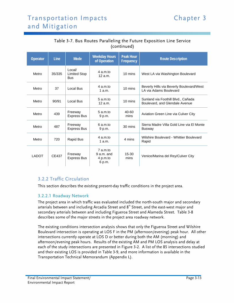
Table 3-7. Bus Routes Paralleling the Future Exposition Line Service
Operator Line Mode Weekday Hours of Operation
Peak Hour Frequency
Route Description
Metro 4 Local Bus 24 Hours 7 mins Santa Monica via Santa Monica Boulevard
Metro 10 Local Bus 5 a.m.to 12 a.m.
7 mins West Hollywood via Temple Street and Melrose Avenue
Metro 14 Local Bus 24 Hours 10 mins Beverly Hills via Beverly Boulevard/West LA via Adams Boulevard
Metro 20 Local Bus 24 Hours 4 mins Santa Monica via Wilshire Boulevard
Metro 26/51/52/352
Local/ Limited Stop Bus
24 Hours 4 mins Hollywood - Compton - Artesia Blue Line via Avalon Boulevard
Metro 28/83/84/328
Local Bus 5 a.m.to 1 a.m.
8 mins Century City via Olympic Boulevard
Metro 33/333 Local/ Limited Stop Bus
24 Hours 2 mins Santa Monica via Venice Boulevard
Transportation Impacts Chapter 3 and Mitigation
Final Environmental Impact Statement/ Page 3-13 Environmental Impact Report
Table 3-7. Bus Routes Paralleling the Future Exposition Line Service (continued)
Operator Line Mode Weekday Hours of Operation
Peak Hour Frequency
Route Description
Metro 35/335 Local/ Limited Stop Bus
4 a.m.to 12 a.m.
10 mins West LA via Washington Boulevard
Metro 37 Local Bus 4 a.m.to 1 a.m.
10 mins Beverly Hills via Beverly Boulevard/West LA via Adams Boulevard
Metro 90/91 Local Bus 5 a.m.to 12 a.m.
10 mins Sunland via Foothill Blvd., Cañada Boulevard, and Glendale Avenue
Metro 439 Freeway Express Bus
5 a.m.to 9 p.m.
40-60 mins
Aviation Green Line via Culver City
Metro 487 Freeway Express Bus
6 a.m.to 9 p.m.
30 mins Sierra Madre Villa Gold Line via El Monte Busway
Metro 720 Rapid Bus 4 a.m.to 1 a.m.
4 mins Wilshire Boulevard - Whittier Boulevard Rapid
LADOT CE437 Freeway Express Bus
7 a.m.to 9 a.m. and 4 p.m.to 6 p.m.
15-30 mins
Venice/Marina del Rey/Culver City
3.2.2 Traffic Circulation This section describes the existing present-day traffic conditions in the project area.
3.2.2.1 Roadway Network The project area in which traffic was evaluated included the north-south major and secondary arterials between and including Arcadia Street and 8th Street, and the east-west major and secondary arterials between and including Figueroa Street and Alameda Street. Table 3-8 describes some of the major streets in the project area roadway network.
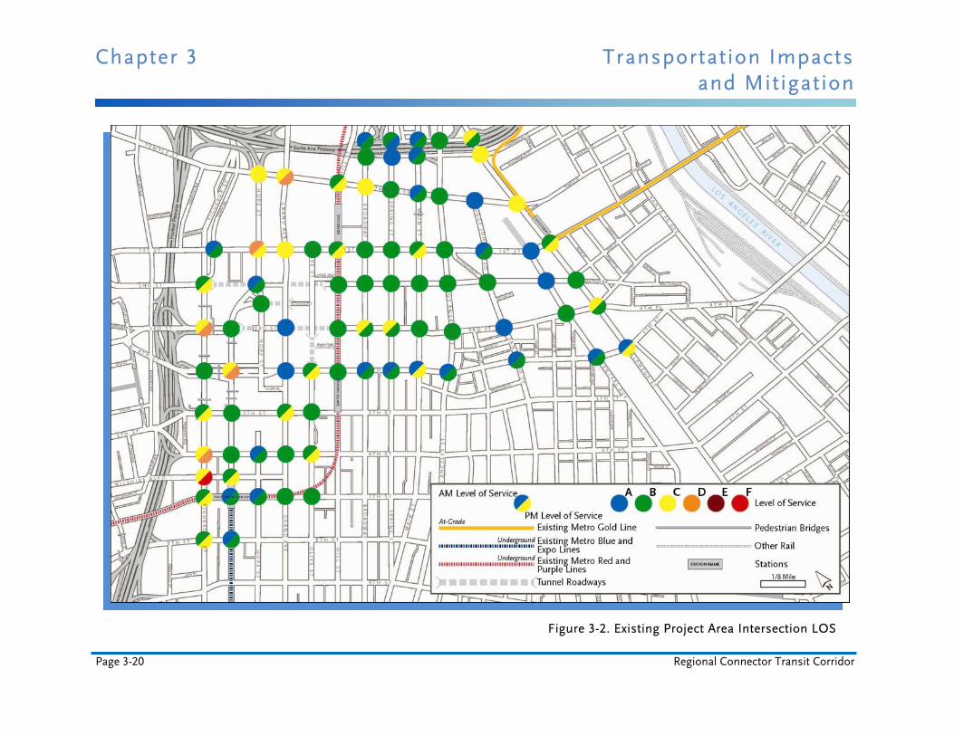
The existing conditions intersection analysis shows that only the Figueroa Street and Wilshire Boulevard intersection is operating at LOS F in the PM (afternoon/evening) peak hour. All other intersections currently operate at LOS D or better during both the AM (morning) and afternoon/evening peak hours. Results of the existing AM and PM LOS analysis and delay at each of the study intersections are presented in Figure 3-2. A list of the 85 intersections studied and their existing LOS is provided in Table 3-9, and more information is available in the Transportation Technical Memorandum (Appendix L).

Chapter 3 Transportation Impacts and Mitigation
Page 3-14 Regional Connector Transit Corridor
Table 3-8. Selected Major Streets
Street Direction Type Vehicles per Day One-Way in Project Area?
Figueroa Street North-South Major Arterial 19,300-32,100 Northbound South of 3rd
Flower Street North-South Secondary Arterial 6,700-17,600 Southbound South of 4th
Grand Avenue North-South Major Arterial 12,300-22,500 Southbound South of 5th
Olive Street North-South Secondary Arterial 13,300-17,300 Northbound South of 5th
Main Street North-South Secondary Arterial 11,000-12,200 Northbound
Los Angeles Street North-South Secondary Arterial 9,000-20,700 No
Alameda Street North-South Major Arterial 26,800-34,000 No
Temple Street East-West Major Arterial 15,100-21,700 No
1st Street East-West Secondary Arterial 14,000-23,300 No
2nd Street East-West Secondary Arterial 11,700-17,100 No
3rd Street East-West Secondary Arterial 17,800-20,800 Westbound East of Flower
5th Street East-West Secondary Arterial 21,200-22,200 Westbound
7th Street East-West Secondary Arterial 16,700-19,700 No
Table 3-9. Existing Intersection Level of Service (LOS) Analysis
No. Intersection AM PM
LOS Delay LOS Delay
1 Grand Avenue / 1st Street C 24.9 C 27.6
2 Hill Street / 1st Street B 16.6 C 27.8
3 Broadway / 1st Street B 15.3 B 16.1
4 Spring Street / 1st Street B 14.2 B 11.5
5 Main Street / 1st Street B 11.7 C 21.4
6 Los Angeles Street / 1st Street B 11.7 B 17.6

Transportation Impacts Chapter 3 and Mitigation
Final Environmental Impact Statement/ Page 3-15 Environmental Impact Report
Table 3-9. Existing Intersection Level of Service (LOS) Analysis (continued)
No. Intersection AM PM
LOS Delay LOS Delay
7 Judge John Aiso Street / 1st Street A 8.8 B 13.6
8 Central Avenue / 1st Street A 5.5 A 8.8
9 Alameda Street / 1st Street B 17.1 C 28.8
10 Figueroa Street / 2nd Street B 19.8 C 30.4
11 Grand Avenue / 2nd Street B 10.3 B 13.1
12 Hill Street / 2nd Street B 13.5 B 11.8
13 Broadway / 2nd Street B 14.5 B 15.5
14 Spring Street / 2nd Street B 15.3 B 12.0
15 Main Street / 2nd Street B 10.4 B 16.8
16 Los Angeles Street / 2nd Street B 11.4 B 18.5
17 San Pedro Street / 2nd Street B 11.3 B 13.6
18 Central Avenue / 2nd Street A 7.4 A 8.3
19 Alameda Street /2nd Street B 10.2 B 13.8
20 Figueroa Street / 3rd Street C 27.9 D 45.0
21 Flower Street / 3rd Street B 19.3 B 10.4
22 Grand Avenue / 3rd Street A 6.7 A 9.8
23 Hill Street / 3rd Street B 18.3 B 18.7
25 Spring Street / 3rd Street C 22.3 B 13.7
26 Main Street / 3rd Street B 13.6 B 15.7
27 Los Angeles Street / 3rd Street B 14.2 B 15.1
28 San Pedro Street / 3rd Street A 10.0 A 9.0
29 Central Avenue / 3rd Street B 12.1 B 11.5
30 Alameda Street / 3rd Street C 21.6 B 12.9

Chapter 3 Transportation Impacts and Mitigation
Page 3-16 Regional Connector Transit Corridor
Table 3-9. Existing Intersection Level of Service (LOS) Analysis (continued)
No. Intersection AM PM
LOS Delay LOS Delay
31 Figueroa Street / 4th Street B 13.2 B 13.3
32 Flower Street / 4th Street C 20.3 D 44.6
33 Grand Avenue / 4th Street A 2.7 A 4.4
34 Figueroa Street / 5th Street B 12.8 C 25.4
35 Flower Street / 5th Street B 13.9 B 16.6
36 Grand Avenue / 5th Street B 14.7 C 24.3
37 Olive Street / 5th Street B 15.4 B 17.7
38 Figueroa Street / 6th Street C 30.8 D 43.6
39 Flower Street / 6th Street B 14.8 B 19.0
40 Hope Street / 6th Street A 6.0 B 10.7
41 Grand Avenue / 6th Street B 13.0 B 15.2
42 Olive Street / 6th Street B 12.6 C 20.0
43 Figueroa Street / Wilshire Blvd. C 21.3 F 117.1
44 Flower Street / Wilshire Blvd. B 14.5 C 22.4
45 Figueroa Street / 7th Street B 19.3 C 27.4
46 Flower Street / 7th Street A 8.9 B 19.8
47 Hope Street / 7th Street A 7.7 B 10.5
49 Olive Street / 7th Street B 12.0 B 16.1
50 Figueroa Street / 8th Street B 13.5 C 20.5
51 Flower Street / 8th Street A 9.4 B 18.8
52 Hope Street / Temple Street C 23.6 C 30.6
53 Grand Avenue / Temple Street C 29.8 D 38.4
54 Hill Street / Temple Street B 17.6 C 33.1

Transportation Impacts Chapter 3 and Mitigation
Final Environmental Impact Statement/ Page 3-17 Environmental Impact Report
Table 3-9. Existing Intersection Level of Service (LOS) Analysis (continued)
No. Intersection AM PM
LOS Delay LOS Delay
55 Broadway / Temple Street C 20.3 C 21.8
56 Spring Street / Temple Street B 14.5 B 12.8
57 Main Street / Temple Street A 8.8 B 19.5
58 Los Angeles Street / Temple Street B 12.5 B 14.7
59 Judge John Aiso Street / Temple Street A 7.5 A 9.7
60 Alameda Street / Temple Street C 22.8 C 34.4
61 Los Angeles Street / Aliso Street B 11.1 B 15.8
62 Alameda Street / Aliso Street C 20.1 C 24.0
63 Los Angeles Street / Arcadia Street B 11.7 B 12.3
64 Alameda Street / Arcadia Street C 22.9 B 15.8
65-1 Alameda Street / N. Los Angeles Street B 13.3 B 10.5
65-2 Alameda Street / S. Los Angeles Street A 4.4 B 10.6
66 Dewap Rd. / 1st Street A 2.7 B 12.1
67 Olive Street / 1st Street B 11.7 B 17.8
68 Hope Street / 1st Street D 35.8 C 25.6
69 S. Hope Street / 2nd Street A 7.0 B 12.2
70 S. Hope Street / Gen. Thaddeus Kosciuszko Way B 15.1 B 17.7
72 Spring Street / Arcadia Street B 12.5 A 9.0
73 Main Street / Arcadia Street A 8.1 B 11.3
74 Broadway / Aliso Street B 12.8 B 11.5
75 Spring Street / Aliso Street A 9.1 A 9.7
76 Main Street / Aliso Street A 5.9 B 11.6
77 Hill Street / 4th Street B 11.5 B 17.0
Chapter 3 Transportation Impacts and Mitigation
Page 3-18 Regional Connector Transit Corridor
Table 3-9. Existing Intersection Level of Service (LOS) Analysis (continued)
No. Intersection AM PM
LOS Delay LOS Delay
78 Olive Street / 4th Street B 14.2 C 24.2
79 Broadway / 4th Street A 9.1 B 15.0
80 Spring Street / 4th Street A 9.9 B 14.9
81 Main Street / 4th Street A 7.2 C 20.3
82 Los Angeles Street / 4th Street A 7.9 B 19.2
83 San Pedro Street / 4th Street A 6.3 B 11.4
84 Central Avenue / 4th Street A 7.3 B 14.3
85 Alameda Street / 4th Street A 8.3 C 32.2
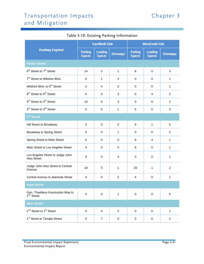
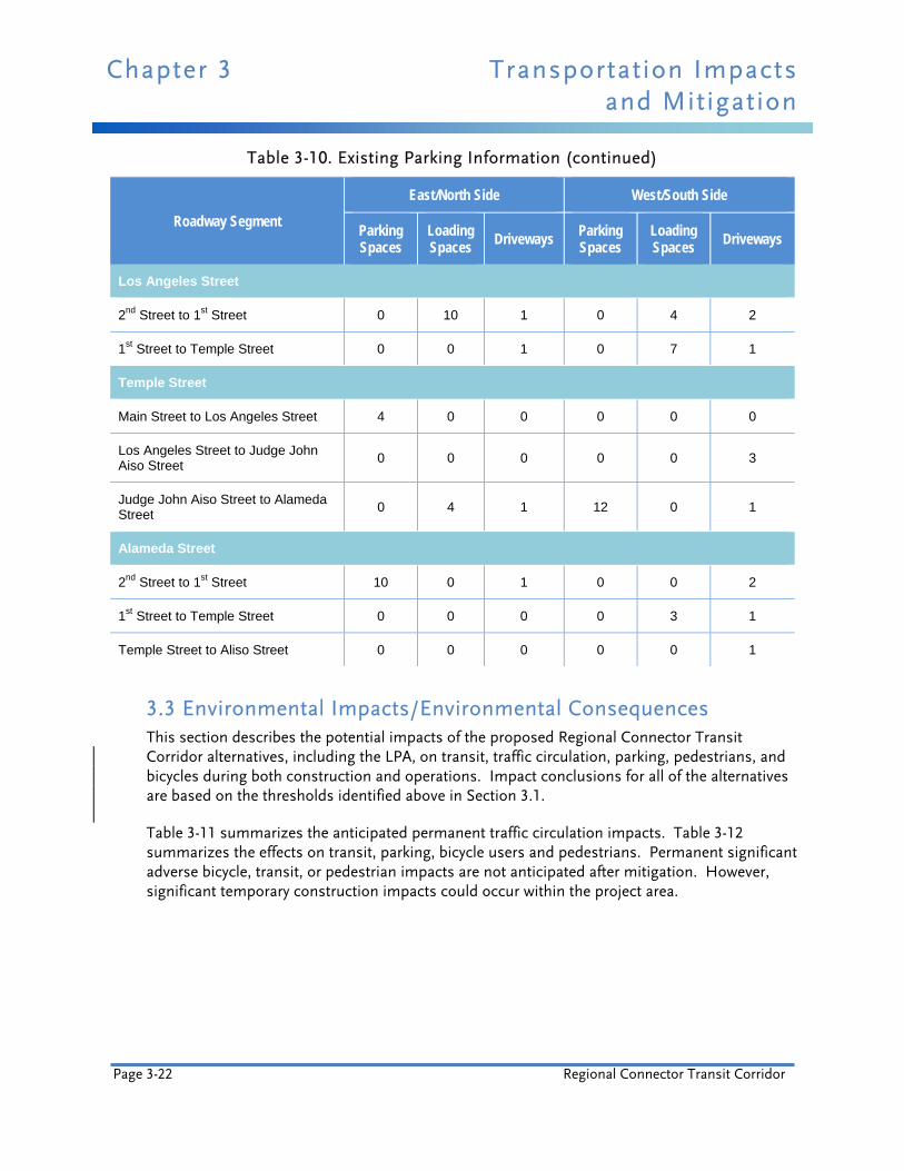
3.2.3 Parking A field visit was performed to collect the number of on-street parking spaces, loading spaces, and driveways that may be affected due to the proposed Regional Connector Transit Corridor project. Results are summarized in Table 3-10. The visit revealed that parking occupancy rates were high at most times of day throughout the project area, so the effects analysis assumes a worst-case scenario (all parking spaces highly utilized) in order to gauge the maximum possible impacts. The specific parking impacts for each alternative are identified in Figures 3-6, 3-8, 3-10, and 3-12. The street segments within each proposed alignment were surveyed to identify the existing number of parking spaces and associated peak period parking restriction information. Along the majority of the proposed build alternative alignments, parking regulations permit on-street parking in one or both directions during the AM and PM peak hours. Refer to Section 4.2, Displacement and Relocation, for analysis of off-street parking impacts.
3.2.4 Pedestrians In urban settings, sidewalks are recommended to be six to 9.8 feet wide. The space closest to the curb allows for a buffer against moving traffic as well as space for street hardware, including light poles and street signs. The City of Los Angeles’ guidelines recommend secondary arterial sidewalk widths of between nine and 10.7 feet. In addition, most of the signalized intersections along the proposed LRT alignments currently have pedestrian call buttons. Crossing tracks at uncontrolled locations is prohibited and signs are placed to guide pedestrians to the nearest safe crossing at a signalized crosswalk location.
Transportation Impacts Chapter 3 and Mitigation
Final Environmental Impact Statement/ Page 3-19 Environmental Impact Report
The central downtown area experiences heavy pedestrian traffic on weekdays, particularly during the commute and lunch hours (City of Los Angeles Planning Department 2003a). Much of the pedestrian traffic occurs in areas with daytime employment such as Bunker Hill, the Financial District, and the Historic Core. Some pedestrian movement occurs between the Civic Center and Little Tokyo along Temple, 1st, and 2nd Streets (City of Los Angeles Planning Department 2003a). Despite heavy pedestrian activity, analysis of the area near the proposed alternatives, including the LPA, did not reveal any particularly problematic pedestrian crossings (insufficient crosswalks, sidewalk overcrowding, inadequate pedestrian walk signal time, etc.).
The Fashion District attracts many pedestrians during both weekdays and weekends, as does Broadway between 2nd and 7th Streets. Due to the location of Wilshire Grand and Sheraton Hotels, 7th Street often experiences large volumes of pedestrians.
Pedestrian activity decreases at night in the central downtown area because much of the daytime population leaves after business hours. The exceptions are Little Tokyo and the Arts District that have experienced a resurgence of evening activity due to increases in new housing in the area and a solid commercial base of restaurants.
To help promote pedestrian and public transit use, the City-developed Angels Walk tours are offered in the downtown area. Each Angels Walk encourages pedestrians to explore important cultural and historic areas of the City. Brochures and maps are provided for self-guided tours. Stanchions located throughout the Angels Walk routes mark important features and provide information in text and photographs.
3.2.5 Bicycles The Metro bicycle plan has designated 1st Street as a future Commuter Bikeway. This is defined as a hybrid of a Class II and Class III bikeway. Class II bikeways are designated striped lanes on surface streets, and Class III bikeways are unstriped bike routes that are designated by green “bike route” signage. Commuter bikeways are unstriped routes that utilize a wide curb lane where parking is prohibited during peak hours. On 1st Street, the commuter bikeway would utilize the curb lane during peak periods. During off-peak hours, bicyclists ride in the traffic stream to avoid striking open car doors. As of April 2010, Metro has identified three Class III bike routes in the project area on 1st, Main, and Spring Streets, as shown in Figure 3-3.
Chapter 3 Transportation Impacts and Mitigation
Page 3-20 Regional Connector Transit Corridor
Figure 3-2. Existing Project Area Intersection LOS
Transportation Impacts Chapter 3 and Mitigation
Final Environmental Impact Statement/ Page 3-21 Environmental Impact Report
Table 3-10. Existing Parking Information
Roadway Segment
East/North Side West/South Side
Parking Spaces
Loading Spaces Driveways
Parking Spaces
Loading Spaces Driveways
Flower Street
8th Street to 7th Street 14 2 1 8 0 3
7th Street to Wilshire Blvd. 0 1 2 0 0 1
Wilshire Blvd. to 6th Street 4 4 0 0 0 1
6th Street to 5th Street 0 0 3 0 4 2
5th Street to 4th Street 13 0 3 0 6 2
4th Street to 3rd Street 0 5 1 5 0 3
2nd Street
Hill Street to Broadway 0 0 0 9 1 0
Broadway to Spring Street 0 0 1 0 0 2
Spring Street to Main Street 0 0 0 6 4 1
Main Street to Los Angeles Street 0 0 0 8 0 1
Los Angeles Street to Judge John Aiso Street
6 0 3 0 0 1
Judge John Aiso Street to Central Avenue
18 5 1 20 1 2
Central Avenue to Alameda Street 4 0 2 4 0 1
Hope Street
Gen. Thaddeus Kosciuszko Way to 2nd Street
0 0 1 0 0 0
Main Street
2nd Street to 1st Street 0 4 2 0 0 1
1st Street to Temple Street 0 7 0 0 6 2
Chapter 3 Transportation Impacts and Mitigation
Page 3-22 Regional Connector Transit Corridor
Table 3-10. Existing Parking Information (continued)
Roadway Segment
East/North Side West/South Side
Parking Spaces
Loading Spaces
Driveways Parking Spaces
Loading Spaces
Driveways
Los Angeles Street
2nd Street to 1st Street 0 10 1 0 4 2
1st Street to Temple Street 0 0 1 0 7 1
Temple Street
Main Street to Los Angeles Street 4 0 0 0 0 0
Los Angeles Street to Judge John Aiso Street
0 0 0 0 0 3
Judge John Aiso Street to Alameda Street
0 4 1 12 0 1
Alameda Street
2nd Street to 1st Street 10 0 1 0 0 2
1st Street to Temple Street 0 0 0 0 3 1
Temple Street to Aliso Street 0 0 0 0 0 1
3.3 Environmental Impacts/Environmental Consequences This section describes the potential impacts of the proposed Regional Connector Transit Corridor alternatives, including the LPA, on transit, traffic circulation, parking, pedestrians, and bicycles during both construction and operations. Impact conclusions for all of the alternatives are based on the thresholds identified above in Section 3.1.
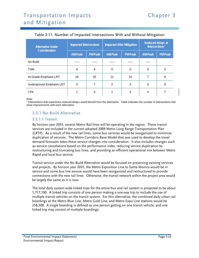
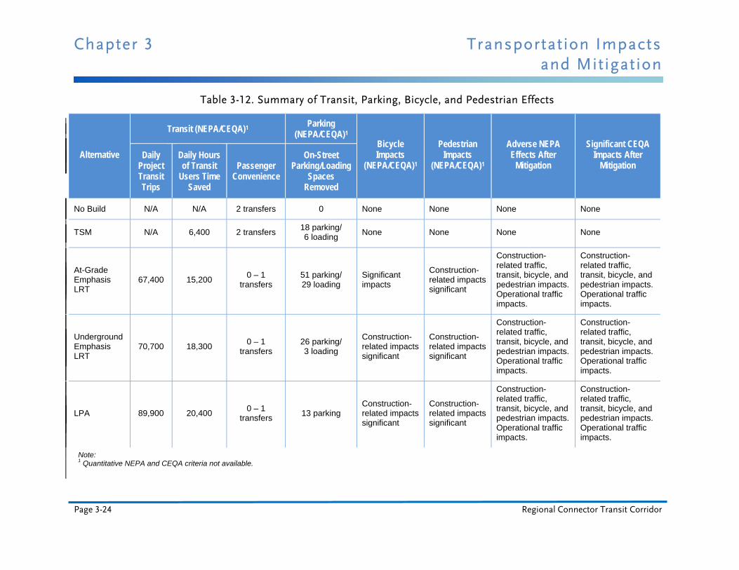
Table 3-11 summarizes the anticipated permanent traffic circulation impacts. Table 3-12 summarizes the effects on transit, parking, bicycle users and pedestrians. Permanent significant adverse bicycle, transit, or pedestrian impacts are not anticipated after mitigation. However, significant temporary construction impacts could occur within the project area.
Transportation Impacts Chapter 3 and Mitigation
Final Environmental Impact Statement/ Page 3-23 Environmental Impact Report
Table 3-11. Number of Impacted Intersections With and Without Mitigation
Alternative Under Consideration
Impacted Intersections Impacted After Mitigation Reduced delays at
Intersections1
AM Peak PM Peak AM Peak PM Peak AM Peak PM Peak
No Build ----- ----- ----- ----- ----
TSM 8 9 0 0 0 0
At-Grade Emphasis LRT 18 26 11 15 7 8
Underground Emphasis LRT 3 7 2 3 5 8
LPA 1 3 1 0 4 7
Note: 1 Intersections that experience reduced delays would benefit from the alternative. Table indicates the number of intersections that show improvements with each alternative.
3.3.1 No Build Alternative
3.3.1.1 Transit By horizon year 2035, several Metro Rail lines will be operating in the region. These transit services are included in the current adopted 2009 Metro Long Range Transportation Plan (LRTP). As a result of the new rail lines, some bus services would be reorganized to minimize duplication of services. The Metro Corridors Base Model that was used to develop the travel demand forecasts takes these service changes into consideration. It also includes changes such as service cancelations based on the performance index, reducing service duplication by restructuring and truncating bus lines, and providing an efficient operational mix between Metro Rapid and local bus service.
Transit service under the No Build Alternative would be focused on preserving existing services and projects. By horizon year 2035, the Metro Exposition Line to Santa Monica would be in service and some bus line service would have been reorganized and restructured to provide connections with the new rail lines. Otherwise, the transit network within the project area would be largely the same as it is now.
The total daily system-wide linked trips for the entire bus and rail system is projected to be about 1,717,100. A linked trip consists of one person making a one-way trip to include the use of multiple transit vehicles on the transit system. For this alternative, the combined daily urban rail boardings at the Metro Blue Line, Metro Gold Line, and Metro Expo Line stations would be 258,500. A single boarding is defined as one person getting on one transit vehicle, and one linked trip may consist of multiple boardings.
Chapter 3 Transportation Impacts and Mitigation
Page 3-24 Regional Connector Transit Corridor
Table 3-12. Summary of Transit, Parking, Bicycle, and Pedestrian Effects
Alternative
Transit (NEPA/CEQA)1 Parking (NEPA/CEQA)1
Bicycle Impacts
(NEPA/CEQA)1
Pedestrian Impacts
(NEPA/CEQA)1
Adverse NEPA Effects After
Mitigation
Significant CEQA Impacts After
Mitigation Daily
Project Transit Trips
Daily Hours of Transit
Users Time Saved
Passenger Convenience
On-Street Parking/Loading
Spaces Removed
No Build N/A N/A 2 transfers 0 None None None None
TSM N/A 6,400 2 transfers 18 parking/ 6 loading
None None None None
At-Grade Emphasis LRT
67,400 15,200 0 – 1
transfers 51 parking/ 29 loading
Significant impacts
Construction-related impacts significant
Construction-related traffic, transit, bicycle, and pedestrian impacts. Operational traffic impacts.
Construction-related traffic, transit, bicycle, and pedestrian impacts. Operational traffic impacts.
Underground Emphasis LRT
70,700 18,300 0 – 1
transfers 26 parking/ 3 loading
Construction-related impacts significant
Construction-related impacts significant
Construction-related traffic, transit, bicycle, and pedestrian impacts. Operational traffic impacts.
Construction-related traffic, transit, bicycle, and pedestrian impacts. Operational traffic impacts.
LPA 89,900 20,400 0 – 1
transfers 13 parking
Construction-related impacts significant
Construction-related impacts significant
Construction-related traffic, transit, bicycle, and pedestrian impacts. Operational traffic impacts.
Construction-related traffic, transit, bicycle, and pedestrian impacts. Operational traffic impacts.
Note: 1 Quantitative NEPA and CEQA criteria not available.
merrillck
Rectangle

Transportation Impacts Chapter 3 and Mitigation
Final Environmental Impact Statement/ Page 3-25 Environmental Impact Report
Figure 3-3. Existing Project Area Bikeways
Chapter 3 Transportation Impacts and Mitigation
Page 3-26 Regional Connector Transit Corridor
It is anticipated that the current bus service would predominantly remain the same through the year 2035 under the No Build Alternative in the project area. There would be shortened headways for some of the heavily traveled lines. In addition, increases along the lines listed in Tables 3-4 through 3-6 would help feed more passengers into the downtown area and into the project area.
Transit patrons would continue to transfer twice to the Metro Red Line and Metro Purple Line through downtown to make a complete east-west or north-south trip. It is expected that transit service performance through the downtown area likely would decrease due to increased traffic congestion. This may make travel via transit a less attractive option for patrons traveling across downtown between Santa Monica and the I-605 vicinity or from Azusa, and eventually Montclair, to Long Beach. For those transit patrons who have no other travel options, travel times would increase and transit usage would be less convenient. As a result, without significant improvements in transit service under the No Build Alternative, a negative impact would occur for those who rely on the public transit system for east-west and north-south travel through the downtown area.
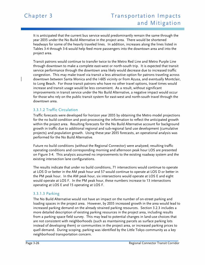
3.3.1.2 Traffic Circulation Traffic forecasts were developed for horizon year 2035 by obtaining the Metro model projections for the no build condition and post-processing the information to reflect the anticipated growth within the project area. Resulting forecasts for the No Build Alternative account for background growth in traffic due to additional regional and sub-regional land use development (cumulative projects) and population growth. Using these year 2035 forecasts, an operational analysis was performed for the No Build Alternative.
Future no build conditions (without the Regional Connector) were analyzed; resulting traffic operating conditions and corresponding morning and afternoon peak hour LOS are presented on Figure 3-4. This analysis assumed no improvements to the existing roadway system and the existing intersection lane configurations.
The results indicate that under no build conditions, 71 intersections would continue to operate at LOS D or better in the AM peak hour and 57 would continue to operate at LOS D or better in the PM peak hour. In the AM peak hour, six intersections would operate at LOS E and eight would operate at LOS F. In the PM peak hour, these numbers increase to 13 intersections operating at LOS E and 15 operating at LOS F.
3.3.1.3 Parking The No Build Alternative would not have an impact on the number of on-street parking and loading spaces in the project area. However, by 2035 increased growth in the area would lead to increased parking demand on the already strained parking resources. Section 3.2.3 includes a more detailed description of existing parking resources in the project area, including results from a parking space field survey. This may lead to potential changes in land-use choices that are not consistent with neighborhoods (such as maintaining parcels as surface parking lots instead of developing them) or communities in the project area, or increased parking prices to quell demand. During scoping, parking was identified by the Little Tokyo community as a key neighborhood transportation concern.
Transportation Impacts Chapter 3 and Mitigation
Final Environmental Impact Statement/ Page 3-27 Environmental Impact Report
3.3.1.4 Other Modes The No Build Alternative would not have impacts on bicycle or pedestrian facilities within the project area. However, increased traffic congestion and deterioration of LOS for traffic segments and intersections would result in performance deterioration of bicycle and pedestrian movements along the project corridor.
3.3.1.5 NEPA Finding The No Build Alternative would not result in adverse transportation effects.
3.3.1.6 CEQA Determination The No Build Alternative would not result in any significant transportation impacts.
3.3.2 TSM Alternative
3.3.2.1 Transit The TSM Alternative proposes two express shuttle bus routes instead of light rail as a link between the 7th Street/Metro Center Station and Union Station. The same provisions for transit service under the No Build Alternative (the projects shown in Metro’s 2009 LRTP) would also be included in the TSM Alternative. The TSM Alternative would not involve any reduction of existing transit service.
The proposed shuttle buses would run every 2.5 minutes during peak hours and every five minutes during off-peak hours to efficiently move passengers between the two stations. The shuttle buses would have traffic signal priority similar to the Metro Rapid system, where the traffic signal control system grants longer green lights to oncoming transit vehicles, to improve bus speeds. Enhanced bus stops would be located every two to three blocks to maximize coverage of the area surrounding the routes. These shuttle routes would be operated by Metro.
For the TSM Alternative, the total daily system-wide linked trips for the entire bus and rail system is projected to be about 1,722,400, which is a 5,300-trip increase over the No Build Alternative. A linked trip consists of one person making a one-way trip, which may include the use of multiple transit vehicles on the transit system. For this alternative, combined daily urban rail boardings are projected to be 258,000 at the Metro Blue Line, Metro Gold Line, and Metro Expo Line stations.
The TSM Alternative would improve the east-west and north-south connections between the stations, although transit patrons would still be required to transfer through downtown in order to make a complete trip.
This may make travel via transit a less attractive option for patrons traveling across downtown between Santa Monica and the I-605 vicinity or from Azusa, and eventually Montclair, to Long Beach. For those transit patrons who have no other travel options, travel times would increase and transit usage would be less convenient than projected under the build alternatives (including the LPA). As a result, there would be a negative impact upon those who rely on the public transit system for east-west and north-south travel through the downtown area.
Chapter 3 Transportation Impacts and Mitigation
Page 3-28 Regional Connector Transit Corridor
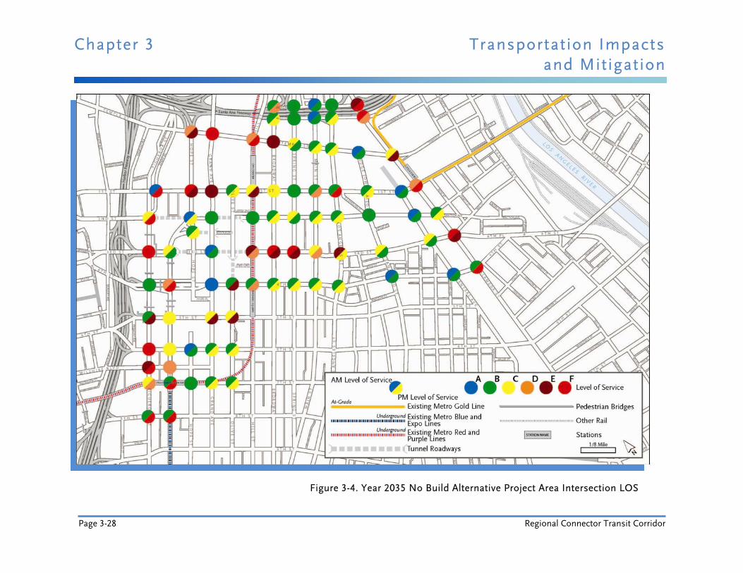
Figure 3-4. Year 2035 No Build Alternative Project Area Intersection LOS
Transportation Impacts Chapter 3 and Mitigation
Final Environmental Impact Statement/ Page 3-29 Environmental Impact Report
Projections show a similar number of urban rail boardings as the No Build Alternative; however, the proposed shuttle bus service is projected to carry 42,700 daily boardings. It is expected that the theoretical carrying capacity would be approximately 3,400 passengers per hour in each direction using 30-foot shuttle buses; though 40-foot shuttle buses could also be used. This alternative would still result in a negative impact on transit-dependent users, though it would be a marginal improvement over the No Build Alternative.
The transit impacts identified under this alternative would be less than significant.
3.3.2.2 Traffic Circulation The results of the traffic analysis and corresponding AM and PM peak hour LOS for this alternative are shown on Figure 3-5. The figure shows the intersections that exceed the significance threshold and are expected to be significantly impacted due to the TSM Alternative, as well as intersections where LOS would improve.
The results indicate that under the TSM Alternative, 71 intersections would continue to operate at LOS D or better in the AM peak hour and 57 would continue to operate at LOS D or better in the PM peak hour. During the AM peak hour, six intersections would operate at LOS E and eight would operate at LOS F. In the PM peak hour, these numbers would increase to 12 intersections operating at LOS E and 16 operating at LOS F. Many of these intersections would operate at the same LOS as projected for the No Build Alternative.
Intersections that are considered to be impacted are those that have a significant negative change in LOS (measured in seconds of delay) when compared to the No Build Alternative conditions (refer to Table 3-2 for thresholds of significance). Chapter 10 includes a comparison of impacts against the existing condition. Eight intersections would be impacted during the AM peak hour and nine intersections would be impacted during the PM peak hour. These impacts would be adverse effects of the TSM Alternative.
The traffic circulation impacts identified would be significant under this alternative.
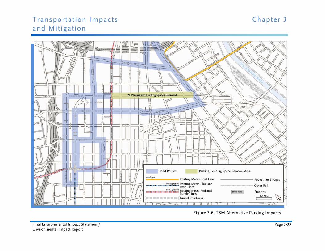
3.3.2.3 Parking The TSM Alternative would not have an impact on the number of on-street parking and loading spaces within the project area where bus stops already exist. However, bus service does not currently exist along portions of the Lower Grand route on 2nd Street, and up to 24 on-street parking and loading spaces would need to be removed to accommodate new bus zones, as shown on Figure 3-6. The actual size of the bus zones would be determined after consulting with LADOT. An attempt would be made to minimize the number of removed parking spaces. The TSM alternative would not cause adverse parking impacts.
3.3.2.4 Other Modes The TSM Alternative would not have impacts on bicycle or pedestrian facilities in the project area. Any impacts that could occur under this alternative would be less than significant. However, increased traffic congestion and deterioration of LOS for traffic segments and
Chapter 3 Transportation Impacts and Mitigation
Page 3-30 Regional Connector Transit Corridor
intersections would result in performance deterioration of bicycle and pedestrian movements along the project corridor.
3.3.2.5 NEPA Finding The TSM Alternative would have adverse transportation effects. These effects could be reduced to a not substantially adverse level by the mitigation measures proposed in Section 3.4 of the Draft EIS/EIR.
3.3.2.6 CEQA Determination The TSM Alternative would not have significant adverse transportation impacts after proposed mitigation measures are considered.
3.3.3 At-Grade Emphasis LRT Alternative
3.3.3.1 Construction Impacts Analysis of potential transportation-related construction impacts was based on proposed construction staging scenarios. Potential adverse impacts that may occur during construction of each alternative were evaluated. Implementation of the No Build or TSM Alternatives would not result in potential disruption to the roadway network and therefore, are not evaluated as part of the construction impacts analysis.
Areas of a roadway where user conditions would be changed due to construction activities are called traffic control zones.
Most of the potential traffic control zones would be divided into the following four areas:
Advance warning area
Transition area
Construction activity area
Termination area
A traffic control zone also includes the streets that would serve as detour routes on traffic control plans, which would be developed in cooperation with LADOT.
Maintenance of traffic lanes during construction would follow LADOT requirements and standards with respect to minimum lane widths, number of lanes, and duration of temporary lane closures. During non-working construction time periods, existing traffic lanes (including turn lanes and two-way left turn lanes) generally would be restored to their pre-construction/original condition unless otherwise authorized by the local jurisdiction.
Street closures would generally be limited to nighttime, weekend, and/or off-peak closures and must be authorized by the local jurisdiction. Closures are not expected during morning and afternoon peak travel periods except for specific areas discussed in the following sections.
Transportation Impacts Chapter 3 and Mitigation
Final Environmental Impact Statement/ Page 3-31 Environmental Impact Report
Potential street closure locations would be identified in close coordination with the local agencies. Potential construction impacts to transit, traffic circulation, parking, and other modes of transportation for each build alternative are evaluated in the following sections.
3.3.3.1.1 Transit Construction of the At-Grade Emphasis LRT Alternative would require temporary closure of traffic lanes in addition to the lanes permanently removed to place the trackway planned for the street during the night, weekends, and/or off-peak hours. Closures would also be required for several blocks at a time on certain streets. When traffic lanes are closed during the day, transit bus service would be maintained where feasible. Travel times may increase due to the potential for increased traffic congestion as a result of construction activities and proposed lane closures.
Relocation of utilities and construction of the trackway, stations, and the proposed Alameda Street underpass at Temple Street would require temporary closure of lanes on Flower Street, Hope Street in the vicinity of General Thaddeus Kosciuszko Way, Main Street, Los Angeles Street, Temple Street, 2nd Street, and Alameda Street over and above the number of lanes permanently removed due to the planned trackway. This would reduce roadway capacity and potentially modify existing traffic patterns as drivers bypass congested areas. Travel times would be impacted for both Metro and non-Metro bus services along these roadways.
Track construction and permanent street re-configuration along 2nd Street would eliminate eastbound vehicular travel on the segment of roadway between Hill Street and Main Street and require permanent closure of one eastbound travel lane between Main Street and Los Angeles Street. A permanent lane closure would occur between Hill Street and Los Angeles Street on the westbound direction of 2nd Street.
During construction, it may be necessary to temporarily close 2nd Street for extended periods between Los Angeles Street and Figueroa Street. Travel times for buses traveling along the westbound direction of 2nd Street are expected to increase and eastbound buses would be re-routed onto 4th Street and/or 1st Street. New bus stop locations would be designated for each specific route that is impacted by this permanent change in traffic flow patterns.
Construction of the proposed Alameda Street underpass at Temple Street would also reduce roadway capacity for extended time periods. To maintain two through travel lanes in each direction, the two-way left turn median would be eliminated in the mid-block area and the exclusive right and left turn lanes at the intersection approaches. The north and south intersection lane configurations would consist of a shared through and right lane and a shared through and left lane for the segment of Alameda Street between Aliso Street and 1st Street.
Existing signal phasing may be changed to split phasing (using green arrows) to minimize conflicts between left turns and opposing through movements, and to minimize the formation of queues as a result of a vehicle waiting for a gap in the opposing traffic to conduct a left turn. Consequently, travel times for buses along this segment of Alameda Street would be expected to increase due to potential traffic congestion. Bus stops within the construction area may be temporarily relocated to minimize vehicular queues behind a bus stopped to pick up and/or drop off passengers.

Chapter 3 Transportation Impacts and Mitigation
Page 3-32 Regional Connector Transit Corridor
Figure 3-5. Year 2035 TSM Alternative Project Area Intersection LOS Potential Impacts
Transportation Impacts Chapter 3 and Mitigation
Final Environmental Impact Statement/ Page 3-33 Environmental Impact Report
Figure 3-6. TSM Alternative Parking Impacts
Chapter 3 Transportation Impacts and Mitigation
Page 3-34 Regional Connector Transit Corridor
Apart from changes to traffic flow patterns on 2nd Street and reduced roadway capacity due to construction of the Alameda Street underpass, it is expected that temporary peak period closures would be minimal. Temporary off-peak period closures would be intermittent, and most construction along the remaining alignment would occur during nighttime and weekend hours. Transit bus service would need to be re-routed due to effects created by night closures of entire street blocks and buses. Construction may require temporary relocation of some bus stops.
Although most potential construction impacts of the At-Grade Emphasis LRT Alternative would be temporary, they would be considered significant and unavoidable.
3.3.3.1.2 Traffic Circulation Construction of the At-Grade Emphasis LRT Alternative would temporarily interfere with the normal flow of traffic, causing some lanes and streets to be temporarily closed to vehicles. It is possible that block-long sections of streets would be temporarily closed for utility relocation, station construction, and installation of rail.
Construction of a typical underground station is estimated to take about 34 months using cut and cover construction methods. The primary impact to traffic, however, is usually associated with the time it takes to install decking over a station box. For stations constructed under existing streets, the top 12 to 15 feet of the roadway would be removed and decking would be installed over an approximately 2- to 3-month period. Decking could be installed temporarily before the 12 to 15 foot depth has been reached in order to allow the roadway to be open to traffic during peak times. Assuming the construction methods used and conditions are similar to Metro’s experience on the Metro Gold Line to East Los Angeles project, the roadway removal and decking could be minimized to several weekends. Construction of the station would continue while traffic travels on the decking. This procedure would require temporary off-peak, nighttime, and/or weekend street closures to install the decking. Traffic would be re-routed to adjacent intersections using clearly signed and marked detours when street closures are required.
For at-grade LRT sections, the street area within and alongside the station areas, supplemented by adjacent sidewalks and off-street areas, would be used for construction staging and equipment and material storage. Haul and delivery truck routes would affect residents and commuters along the alignment. Tunnel spoil hauling, rail and catenary deliveries, and general construction traffic would impact traffic flow patterns as well. In addition to affecting traffic movements, there may be slight physical damage to roads from hauling trucks.
Relocation of utilities and construction of the trackway, stations, and the proposed Alameda Street underpass would require temporary closure of lanes. This would reduce roadway capacity and potentially modify existing traffic patterns as drivers bypass congested areas. Vehicular travel times and intersection operations would be impacted along these roadways.
Track construction and permanent street re-configuration along 2nd Street would eliminate eastbound vehicular travel on the segment of roadway between Hill Street and Main Street and require permanent closure of one eastbound travel lane between Main and Los Angeles Streets.

Transportation Impacts Chapter 3 and Mitigation
Final Environmental Impact Statement/ Page 3-35 Environmental Impact Report
For the westbound direction of 2nd Street, a one-lane permanent closure would occur between Hill Street and Los Angeles Street. It may be necessary to temporarily close 2nd Street for extended periods of time between Los Angeles Street and Figueroa Street during construction.
Travel times are expected to increase for vehicles traveling along the westbound direction of 2nd Street. Eastbound vehicular through traffic would be re-routed onto 4th Street and/or 1st Street, depending on their origin and destination. The shift in traffic onto both 4th and 1st Streets would increase delays at several intersections between Hill Street and Los Angeles Street.
Construction of the proposed Alameda Street underpass at Temple Street would reduce roadway capacity for extended periods of time. Maintaining two through travel lanes in each direction during construction would require elimination of the two-way left turn median in the mid-block area and the exclusive right and left turn lanes at the intersection approaches. The north and south intersection lane configurations would consist of a shared through and right lane and a shared through and left lane for the segment of Alameda Street between Aliso Street and 1st Street.
The existing signal phasing may be changed to split phasing to minimize conflicts between left turns and opposing through movements. This change would also minimize the formation of queues resulting from vehicles waiting for a gap in the opposing traffic to make a left turn. Consequently, travel times along this segment of Alameda Street would be expected to increase due to increased traffic congestion during peak periods and, to a lesser extent, during off-peak periods. Operating conditions would also be expected to deteriorate for Alameda Street intersections between Aliso Street and 1st Street.
Apart from traffic flow patterns, changes on 2nd Street, and reduced roadway capacity from construction of the Alameda Street underpass, temporary peak period closures would be minimal and temporary off-peak period closures would be intermittent. Most construction along the rest of the alignment would take place during the nighttime and weekend hours. Traffic would be re-routed and detours clearly signed and marked during night closures of entire street blocks.
Construction haul routes would be on existing freight routes, and haul trips would take place during off-peak hours when there is excess capacity on the roadway network. Routes would be confirmed during the final design phase of the project. Haul routes are described in more detail in Section 4.18.2.3.
Although the majority of the impacts identified under the At-Grade Emphasis LRT Alternative would be temporary, they would be significant and unavoidable.
3.3.3.1.3 Parking It may be necessary to prohibit on-street parking when traffic lanes are closed or eliminated due to construction activities. Existing parking meters within the traffic control zone of influence that would be affected by construction would be removed or covered as directed by the agency with jurisdiction. To minimize the loss of crucial commercial parking, contractors would be required to have all employees park off-street at Metro-approved locations.
Chapter 3 Transportation Impacts and Mitigation
Page 3-36 Regional Connector Transit Corridor
During construction, the At-Grade Emphasis LRT Alternative would require temporary closure of lanes. Consequently, existing on-street parking spaces and loading stalls would be temporarily removed. This would impact parking spaces and loading areas on the east and west sides of Flower Street, the loading areas on the east side of Main Street and Los Angeles Street, and the parking spaces on the south side of Temple Street. In addition, the realigned intersection of Hope Street in the vicinity of General Thaddeus Kosciuszko Way may temporarily require removal of several parking spaces along both the east and west sides of that roadway segment.
Track construction and permanent street re-configuration along 2nd Street would temporarily remove several parking and loading stalls. In the vicinity of the Alameda Street underpass, the Japanese American National Museum tour bus loading zone on the west side of the street would be permanently removed and relocated.
Parking impacts identified during construction of the At-Grade Emphasis LRT Alternative would be adverse only in the Little Tokyo community portion of the alignment, but even there impacts would be less than significant after implementation of proposed mitigation.
3.3.3.1.4 Other Modes When construction encroaches into a sidewalk, walkway, or crosswalk area, special consideration would be given to pedestrian safety. Pedestrian access to adjoining properties and bicycle traffic movements would be maintained during construction; however, portions of sidewalks may be temporarily closed for decking construction at cut and cover station areas. Temporary nighttime closures of sidewalks and crosswalks may be necessary. Lane reductions and street closures could inhibit the flow of bicycle traffic during construction.
The At-Grade Emphasis LRT Alternative includes track construction and permanent street configuration changes along 2nd Street and construction of an underpass on Alameda Street. Both would require lane closures for extended periods of time and may also require temporary sidewalk closures. Construction along 2nd Street would shift some of the through traffic movements onto 1st Street, which is designated as a Class III bicycle route. Consequently, the flow of bicycle traffic could be hampered due to increased traffic volumes on 1st Street.
The At-Grade Emphasis LRT Alternative includes cut and cover station construction along segments of Flower Street and construction of an underpass on Alameda Street. Both may require temporary sidewalk closures, which would impact pedestrian flow. Construction of the underpass on Alameda Street may result in localized shifts in traffic to adjacent roadway segments such as Central Avenue. Similarly, the increase in traffic volumes would impact the flow of bicycle traffic. Temporary sidewalk closures during construction of this alternative would also impact pedestrian flow.
Although temporary, the identified potential impacts during construction on pedestrian and bicycle movements would be significant and unavoidable.
Transportation Impacts Chapter 3 and Mitigation
Final Environmental Impact Statement/ Page 3-37 Environmental Impact Report
3.3.3.2 Operational Impacts
3.3.3.2.1 Transit The At-Grade Emphasis LRT Alternative consists of a light rail alignment to provide a link between the 7th Street/Metro Center Station and Metro Gold Line at Temple and Alameda Streets. All of the provisions for transit service under the No Build Alternative (the projects shown in Metro’s 2009 LRTP) would also be included. The alignment east of 2nd and Hope Streets and the crossing at the 3rd and Flower Streets intersection would be at-grade and the remainder (Flower Street between 7th and 3rd Streets along with the station at 2nd and Hope Streets) would be underground.
The Regional Connector project would provide a direct east-west route between the I-605 vicinity and Santa Monica and a direct north-south route between the cities of Azusa, and eventually to Montclair, and Long Beach. Consequently, transit patrons could travel from east-west or north-south without having to make a transfer in the downtown area. With this alternative, the existing Little Tokyo/Arts District Station would serve only east-west travel. Passengers originating in the communities of Little Tokyo and the Arts District would need to board trains at the Main/Los Angeles couplet stations to make trips north and south, or board a train at the Little Tokyo/Arts District Station and transfer after one stop.
For the At-Grade Emphasis LRT Alternative, the total daily system-wide linked transit trips for the entire bus and rail system is projected to be about 1,729,400, which is a 12,300-trip increase over the No Build Alternative and a 7,000-trip increase over the TSM Alternative. Combined daily urban rail boardings for this alternative are projected to be 275,700 at the Metro Blue Line, Metro Gold Line, Metro Expo Line, and the proposed new Regional Connector Transit Corridor stations. The projections show an increase of about 17,200 in urban rail boardings—a benefit of this alternative. It is also expected that the theoretical carrying capacity of the LRT system would be approximately 13,000 passengers per hour in each direction.
Bus operating speeds may decrease because of the proposed traffic lane reductions along Flower, 2nd, Main, Los Angeles, Temple, and Alameda Streets, which would negatively impact congestion on these streets. In addition, eastbound bus stops on 2nd Street would be displaced and buses traveling eastbound on 2nd Street would be shifted to adjacent roadways such as 1st or 4th Streets. Bus schedules would be adjusted to reflect modified traffic conditions and travel times. However, from an urban rail perspective, this alternative would have a significant benefit when compared to both the No Build and TSM Alternatives. Existing bus service would not be reduced as part of this alternative. In summary, the transit impacts identified under this alternative would be less than significant.
3.3.3.2.2 Traffic Circulation The entrances for the Flower/6th/5th Street station would require a lane to be removed on Flower Street between 4th and 6th Streets. As such, LOS at intersections along this segment of Flower Street would worsen.
Due to the narrow width of 2nd Street, only one westbound travel lane would be maintained to provide local business and driveway access and the two eastbound travel lanes would be eliminated between Hill and Main Streets. Consequently, eastbound through traffic would be
Chapter 3 Transportation Impacts and Mitigation
Page 3-38 Regional Connector Transit Corridor
diverted to 1st and 4th Streets and westbound through traffic would be diverted to 1st and 3rd Streets.
The proposed Alameda Street underpass at Temple Street would result in localized traffic shifts to adjacent intersections because some of the at-grade north-south turn movements would be eliminated from Alameda Street to Temple Street. These shifts in traffic patterns and roadway circulation are reflected in the year 2035 AM and PM peak hour traffic forecasts for the At-Grade Emphasis LRT Alternative and the reduction in traffic lanes is reflected in the intersection lane configurations.
Traffic signals along the LRT alignment would require modifications for at-grade operations to provide adequate time for the trains to safely clear an intersection. The intersection analysis accounts for this exclusive signal phase for LRT operations that would be necessary at most locations. The results of the traffic analysis for this alternative and corresponding AM and PM peak hour LOS are presented on Figure 3-7. The figure shows the intersections that would exceed the significance threshold and would be significantly impacted due to the At-Grade Emphasis LRT Alternative, as well as at the intersections where LOS would improve.
The results indicate that under the At-Grade Emphasis LRT Alternative, 65 intersections would continue to operate at LOS D or better in the AM peak hour and 48 intersections would continue to operate at LOS D or better in the PM peak hour. In the AM peak hour, seven intersections would operate at LOS E and 13 intersections would operate at LOS F. In the PM peak hour, these numbers would increase to 12 intersections operating at LOS E and 25 operating at LOS F. Many of these intersections would operate at the same LOS as projected for the No Build Alternative. During the AM peak hour, seven intersections show delay improvements, and eight intersections show delay improvements during the PM peak hour.
Intersections that would be impacted include those that are projected to have a significant negative change in LOS when compared to the No Build Alternative conditions (refer to Table 3-2 for thresholds of significance). During the AM peak hour 18 intersections and during the PM peak hour 26 intersections would experience significant adverse impacts under the At-Grade LRT Alternative.
In summary, the traffic circulation impacts identified under this alternative would be significant.
3.3.3.2.3 Parking Portions of the At-Grade Emphasis LRT Alternative alignment would utilize existing roadway space for tracks, surface street stations, underground station pedestrian entrances, and a roadway underpass on Alameda Street. A reduction in traffic lanes and/or parking spaces would occur along the street segments at these locations. The number of parking and loading spaces that would be removed was estimated based on the characteristics of each street segment and the proposed LRT street cross-sections. Potential parking impacts are shown on Figure 3-8.
Parking losses identified under the At-Grade Emphasis LRT Alternative would result in an adverse impact only in the Little Tokyo community portion of the alignment, but even there the potential impact would be less than significant after implementation of proposed mitigation.
Transportation Impacts Chapter 3 and Mitigation
Final Environmental Impact Statement/ Page 3-39 Environmental Impact Report
3.3.3.2.4 Other Modes For the At-Grade Emphasis LRT Alternative, the street and intersection locations where the LRT would have an at-grade profile include Flower Street between 4th and 3rd Streets, 2nd Street between Hill and Los Angeles Streets, Main and Los Angeles Streets between Temple and 2nd Streets, Temple Street between Main and Alameda Streets, and Alameda Street between Aliso and 2nd Streets. The alignment would utilize existing roadway space for tracks, surface street stations, underground station pedestrian entrances, and a roadway underpass on Alameda Street. The reduction in travel lanes would impact bikeways and pedestrian crosswalks and sidewalks as it would traffic and transit.
The sidewalk along Flower Street between 6th and 3rd Streets and along 2nd Street between Hill and Los Angeles Streets would be maintained and could be widened. No pedestrian impacts would be expected for the at-grade segments of the alignment. A station is proposed on each side of the one-way couplet on Main and Los Angeles Streets just north of 1st Street. At station areas, the LRT would be located near major signalized intersections, where pedestrian crosswalks are currently in place. The station layouts would be designed for pedestrian convenience and safety, leading to crosswalks at signalized intersections to guide pedestrians toward safe flow patterns.
The sidewalk and its associated width would be maintained along Temple Street. Where the tracks would cross Alameda Street, a pedestrian bridge is proposed to reduce potential conflicts between pedestrians, trains, and automobiles.
The possibility of conflicts between trains and pedestrians may also occur at the tunnel portal location on Flower Street south of 3rd Street where pedestrians could attempt to enter the tunnel during daytime operations or at night. Signing and surveillance would be utilized at tunnel portals to reduce the possibility of unauthorized tunnel entry. Potentially significant pedestrian safety issues associated with unauthorized pedestrian crossings of the tracks would be addressed during design and utilization of Metro standards would be implemented to minimize possible conflicts. A pedestrian bridge could also be constructed between the 2nd/Hope Street station and Upper Grand Avenue to enhance the connection to Bunker Hill.
The at-grade alignment would not directly impact designated bicycle routes. However, some of the through traffic currently on 2nd Street would be expected to shift onto 1st Street. Consequently, the flow of bicycle traffic could be impacted due to increased traffic volumes on 1st Street. Bicyclists could be traveling in a more congested environment due to the projected increase in traffic volumes on 1st Street.
Similarly, the proposed underpass at Alameda and Temple Streets would be expected to divert some local traffic to adjacent streets, such as Central Avenue, because of potential changes in traffic circulation patterns. Therefore, the flow of bicycle traffic could be impacted due to increased traffic volumes on Central Avenue as a result of this potential localized shift in traffic. Potential bicycle impacts would be significant under this alternative.
Transit stations would be provided with bike lockers and racks, increasing the bicycle facilities in the area and creating a positive impact. In addition, pedestrian level lighting at stations would
Chapter 3 Transportation Impacts and Mitigation
Page 3-40 Regional Connector Transit Corridor
improve the attractiveness and perception of safety, specifically in the evening hours, creating a positive effect for patrons and the community.
3.3.3.3 NEPA Finding The At-Grade Emphasis LRT Alternative would have potentially adverse transportation effects. Potentially adverse construction-related effects to traffic, transit, bicycle, and pedestrian circulation would remain after mitigation. Potentially adverse operational traffic circulation effects would also remain even with implementation of proposed mitigation measures.
3.3.3.4 CEQA Determination The At-Grade Emphasis LRT Alternative would have potentially significant adverse transportation impacts. Potentially significant construction-related impacts to traffic, transit, bicycle, and pedestrian circulation would remain after mitigation. Potentially significant operational traffic circulation impacts would also remain even with implementation of proposed mitigation measures.
3.3.4 Underground Emphasis LRT Alternative
3.3.4.1 Construction Impacts
3.3.4.1.1 Transit Relocation of utilities and the construction of cut and cover stations and the proposed Alameda Street underpass at 1st Street would require temporary closure of lanes on Flower Street, Hope Street in the vicinity of General Thaddeus Kosciuszko Way, and Alameda Street. This would reduce roadway capacity and potentially modify existing traffic patterns as drivers bypass congested areas.
Travel times would be impacted for both Metro and non-Metro bus services along these roadways. Temporary peak period closures would be minimal and temporary off-peak period closures would be intermittent, especially if most construction for station areas affecting surface lanes takes place during the nighttime and weekend hours similar to the methods used for the Metro Gold Line to East Los Angeles project. Transit bus service may be affected and buses would be re-routed during night closures. Accordingly, some bus stops may need to be temporarily relocated due to construction.
Construction of the proposed Alameda Street underpass at 1st Street would reduce roadway capacity for extended times during construction. To maintain two through travel lanes in each direction, the two-way left turn median would be eliminated in the mid-block area and the exclusive right and left turn lanes would be eliminated at the intersection approaches. The north and south intersection lane configurations would consist of a shared through and right lane and a shared through and left lane for the segment of Alameda Street between Temple Street and 2nd Street.

Transportation Impacts Chapter 3 and Mitigation
Final Environmental Impact Statement/ Page 3-41 Environmental Impact Report
Figure 3-7. Year 2035 At-Grade Emphasis LRT Alternative Project Area Intersection LOS Potential Impacts
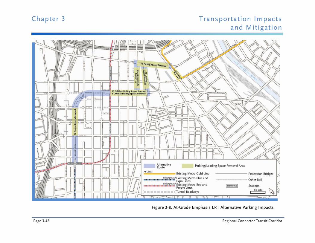
Chapter 3 Transportation Impacts and Mitigation
Page 3-42 Regional Connector Transit Corridor
Figure 3-8. At-Grade Emphasis LRT Alternative Parking Impacts
Transportation Impacts Chapter 3 and Mitigation
Final Environmental Impact Statement/ Page 3-43 Environmental Impact Report
Existing signal phasing may be changed to split phasing to minimize potential conflicts between left turns and opposing through movements and prevent formation of queues as a result of a vehicle waiting for a gap in the opposing traffic to conduct a left turn movement. Therefore, travel times for buses operating along this segment of Alameda Street would be expected to increase due to the potential for increased traffic congestion. Bus stops within the construction area may need to be temporarily relocated to minimize the formation of vehicular queues behind a bus stopped to pick up and/or drop off passengers.
Although most impacts identified under the Underground Emphasis LRT Alternative may be temporary, they would be significant and unavoidable.
3.3.4.1.2 Traffic Circulation Construction activities for the Underground Emphasis LRT Alternative would require temporary closure of lanes on Flower Street, Hope Street in the vicinity of General Thaddeus Kosciuszko Way, 2nd Street, and Alameda Street. This would reduce roadway capacity and potentially modify existing traffic patterns as drivers bypass congested areas. Vehicular travel times and intersection operations along these roadways would be impacted.
It is anticipated that temporary peak period closures would be minimal and temporary off-peak period closures would be intermittent, with most station area construction activities that affect surface streets taking place during the nighttime and weekend hours similar to the methods used for the Metro Gold Line to East Los Angeles project. During night closures, traffic flow patterns may be affected, but would be re-routed accordingly with clearly signed and marked detours.
Construction of a typical underground station is estimated to take about 34 months using cut and cover construction methods. However, the primary impact to traffic would be associated with the time it takes to install decking over the station box. At each potential station location this duration would be approximately several weekends, assuming that the construction methods used would be similar to those used on the Metro Gold Line to East Los Angeles.
For stations constructed under existing streets, the top 12 to 15 feet of the roadway would be removed and decking would be installed over an approximately 2- to 3-month period. Decking could be installed temporarily before the 12 to 15 foot depth has been reached in order to allow the roadway to be open to traffic during peak times. Construction of the station would continue while traffic travels on the decking. This procedure would require temporary off-peak, nighttime, and/or weekend street closures to install the decking. As these street closures are identified, traffic would be re-routed to adjacent intersections with clearly signed and marked detours.
Construction of the tunnels beneath 2nd Street using TBMs would require spoils to be hauled to off-site disposal locations. In order to avoid traffic impacts, truck haul trips would be scheduled along existing freight routes during off-peak hours, when there is extra capacity available in the downtown area. Routes and disposal sites would be confirmed during the final design phase of the project.

Chapter 3 Transportation Impacts and Mitigation
Page 3-44 Regional Connector Transit Corridor
Roadway capacity would be reduced for extended time periods during construction of the proposed Alameda Street underpass at 1st Street. In order to maintain two through travel lanes in each direction, the two-way left turn median in the mid-block area and the exclusive right and left turn lanes at the intersection approaches would be eliminated. The north and south intersection lane configurations would consist of a shared through and right lane and a shared through and left lane for the segment of Alameda Street between Temple Street and 2nd Street.
Existing signal phasing may be changed to split phasing to minimize conflicts between left turns and opposing through movements and prevent the formation of queues as a result of vehicles waiting for a gap in the opposing traffic to conduct a left turn movement. Therefore, travel times for vehicles traveling along this segment of Alameda Street would be expected to increase. In addition, operating conditions for the Alameda Street intersections between Temple Street and 2nd Street would be expected to deteriorate.
Although most impacts from this alternative may be temporary, they would be significant and unavoidable.
3.3.4.1.3 Parking Parking impacts under the Underground Emphasis LRT Alternative include temporary closure of lanes. Consequently, existing on-street parking spaces and loading stalls would be temporarily removed. This would impact parking spaces and loading areas on the east and west sides of Flower Street. The realigned intersection of Hope Street in the vicinity of General Thaddeus Kosciuszko Way may temporarily require removal of several parking spaces along both the east and west sides of the roadway segment.
In the vicinity of the Alameda Street underpass, the Japanese American National Museum tour bus loading zone on the west side of the street would be permanently removed and relocated. In addition, several parking spaces would be temporarily displaced from the east side of the roadway segment between 1st and 2nd Streets.
Parking impacts of the Underground Emphasis LRT Alternative during construction would be adverse only in the Little Tokyo community portion of the alignment, but even there impacts would be less than significant after implementation of proposed mitigation.
3.3.4.1.4 Other Modes The Underground Emphasis LRT Alternative includes cut and cover station construction along segments of Flower Street and construction of an underpass on Alameda Street. Both may require temporary sidewalk closures, which would impact pedestrian flow. In addition, construction of the underpass on Alameda Street may result in localized shifts in traffic to adjacent roadway segments such as Central Avenue. Therefore, the flow of bicycle traffic could be impacted due to increased traffic volumes on these adjacent streets.
Although temporary, the potential impacts on pedestrian and bicycle movements during construction of the Underground Emphasis LRT Alternative would be significant and unavoidable.

Transportation Impacts Chapter 3 and Mitigation
Final Environmental Impact Statement/ Page 3-45 Environmental Impact Report
3.3.4.2 Operational Impacts
3.3.4.2.1 Transit The Underground Emphasis LRT Alternative would include an underground light rail alignment to provide a link between the 7th Street/Metro Center Station and Metro Gold Line at 1st and Alameda Streets. All of the provisions for transit service under the No Build Alternative (the projects shown in Metro’s 2009 LRTP) would also be included.
The proposed alignment would surface to an at-grade configuration on Alameda Street at 1st Street. This alternative would provide a direct east-west route between Santa Monica and the I-605 vicinity and a direct north-south route between Azusa, and eventually to Montclair, and Long Beach. Consequently, transit patrons could travel from east-west or north-south without having to make a transfer in the downtown area.
The existing Little Tokyo/Arts District Station would serve only patrons traveling along the north-south route. Patrons from the Little Tokyo and Arts District communities would need to board a train at the proposed 2nd and Broadway station or the 2nd and Los Angeles station, whichever is selected, to travel east and west. Alternatively, patrons could board a train at the Little Tokyo/Arts District Station and transfer at the next stop.
For the Underground Emphasis LRT Alternative, the total daily system-wide linked transit trips for the entire bus and rail system is projected to be about 1,732,000, which would be a 14,900-trip increase over the No Build Alternative and a 9,600-trip increase over the TSM Alternative. The daily urban rail boarding count for this alternative is projected to be 280,000 at the Metro Blue Line, Metro Gold Line, Metro Expo Line, and the proposed new Regional Connector stations combined. The projections show an increase of about 21,500 in urban rail boardings, which would be a positive impact of this alternative. The theoretical carrying capacity of the downtown LRT system would be approximately 13,000 passengers per hour in each direction under this alternative.
Bus operating speeds may decrease due to proposed traffic lane reductions along Flower and Alameda Streets that would impact congestion on these streets. Bus schedules would be adjusted to reflect modified traffic conditions and travel times. However, from an urban rail perspective, this alternative shows a significant positive impact compared to both the No Build and TSM Alternatives. Existing bus service would not be reduced as part of this alternative. In summary, the transit impacts identified under this alternative would be less than significant.
3.3.4.2.2 Traffic Circulation The Underground Emphasis LRT Alternative would be a predominantly underground alignment with one at-grade segment crossing Alameda Street to connect with the Gold Line tracks at the Little Tokyo/Arts District Station. To accommodate pedestrian station entrances to an underground station, one traffic lane would be removed on the east side of Flower Street between 6th and 4th Streets, resulting in increased intersection congestion along this segment of Flower Street. The proposed Alameda Street underpass at 1st Street would result in localized traffic shifts to adjacent intersections because some of the at-grade north-south turn movements from Alameda Street to 1st Street would be eliminated.
Chapter 3 Transportation Impacts and Mitigation
Page 3-46 Regional Connector Transit Corridor
The at-grade segment of the Underground Emphasis LRT Alternative would require modifications to the traffic signal at 1st and Alameda Streets to provide adequate time for the trains to safely clear the intersection. In this area, some of the trains would be traveling at slow speeds because they would be approaching or leaving the Little Tokyo/Arts District Station.
These local shifts in traffic patterns and changes to the roadway circulation are reflected in the year 2035 AM and PM peak hour traffic forecasts for the Underground Emphasis LRT Alternative, and the proposed reduction in traffic lanes is reflected in the intersection lane configurations.
The results of the traffic analysis for this alternative and corresponding predicted AM and PM peak hour levels of service are presented in Figure 3-9. In addition, the figure shows the intersections that would exceed the significance threshold and that would be expected to be significantly impacted due to the Underground Emphasis LRT Alternative, as well as intersections where LOS would improve.
The results indicate that under the Underground Emphasis LRT Alternative, 69 intersections would continue to operate at LOS D or better in the AM peak hour and 55 would continue to operate at LOS D or better in the PM peak hour. In the AM peak hour, seven intersections would operate at LOS E and nine would operate at LOS F. In the PM peak hour, these numbers increase to 13 intersections operating at LOS E and 17 operating at LOS F. Many of these intersections would operate at the same LOS as projected for the No Build Alternative. During the AM peak hour, five intersections show delay improvements, while eight intersections show delay improvements in the PM peak hour.
Intersections that would be impacted include those that are projected to have a significant negative change in LOS when compared to the No Build Alternative conditions (refer to Table 3-2 for thresholds of significance). Only three intersections during the AM peak hour and only seven intersections during the PM peak hour would experience significant adverse impacts of the Underground Emphasis LRT Alternative.
In summary, the traffic circulation impacts identified under this alternative would be significant.
3.3.4.2.3 Parking Portions of the Underground Emphasis LRT Alternative alignment would use existing roadway space for underground station pedestrian entrances and a roadway underpass on Alameda Street. At these locations, there would be a reduction in traffic lanes and/or parking spaces. The number of parking and loading spaces that would be removed was estimated based on the characteristics of each street segment and the proposed street cross-sections. The expected impacts along each of the street segments that the alignment would traverse are shown in Figure 3-10.
The parking impacts identified under this alternative would be adverse only in the Little Tokyo community portion of the alignment, but even there impacts would be less than significant after implementation of proposed mitigation. Refer to Section 4.2, Displacement and Relocation, for analysis of off-street parking impacts.
Transportation Impacts Chapter 3 and Mitigation
Final Environmental Impact Statement/ Page 3-47 Environmental Impact Report
3.3.4.2.4 Other Modes For the Underground Emphasis LRT Alternative, the only street and intersection location where the LRT has an at-grade profile would be in the vicinity of Alameda Street at 1st Street. The alignment would utilize existing roadway space for tracks, underground station pedestrian entrances, and a roadway underpass on Alameda Street. Urban design concepts may be incorporated at these locations to improve pedestrian and bicycle safety and flow.
The sidewalk along Flower Street between 6th and 3rd Streets and along 2nd Street at the underground station pedestrian entrances would be maintained or widened. No pedestrian impacts would be expected for these segments of the alignment. At station areas, pedestrian station entrances would be located near major signalized intersections, where pedestrian crosswalks are currently in place. Where the tracks cross Alameda Street, a pedestrian bridge is proposed to reduce potential conflicts between pedestrians, trains, and automobiles.
The tunnel portal would be located in the lot bounded by 1st Street, Alameda Street, 2nd Street, and Central Avenue. Signing and surveillance would be utilized at this tunnel portal to reduce the possibility of unauthorized tunnel entry. Potentially significant pedestrian safety issues associated with unauthorized pedestrian crossings of the tracks at 1st and Alameda Streets would be addressed during design and use Metro standards to minimize possible conflicts. A pedestrian bridge could also be constructed between the 2nd/Hope Street station and Upper Grand Avenue to enhance the connection to Bunker Hill.
The underground alignment would not directly impact designated bicycle routes. However, the proposed underpass on Alameda Street at 1st Street and potential changes in traffic circulation patterns may result in the diversion of local traffic to adjacent roadway segments such as Central Avenue. Consequently, the flow of bicycle traffic may be impacted by increased traffic volumes on these adjacent streets resulting from a potential localized shift in traffic. The impacts identified under this alternative would be less than significant.
Proposed stations would include bike lockers and racks, increasing the bicycle facilities in the area and creating a positive impact. In addition, pedestrian level lighting at stations would improve the attractiveness and perception of safety, specifically in the evening hours, creating a positive effect for patrons and the community.
3.3.4.3 NEPA Finding The Underground Emphasis LRT Alternative would have adverse transportation effects. Potentially adverse construction-related effects to traffic, transit, bicycle, and pedestrian circulation would remain after mitigation. Potentially adverse operational traffic circulation impacts would also remain even with implementation of proposed mitigation measures.
3.3.4.4 CEQA Determination The Underground Emphasis LRT Alternative would have potentially significant adverse transportation impacts. Potentially significant construction-related impacts to traffic, transit, bicycle, and pedestrian circulation would remain after mitigation. Potentially significant operational traffic circulation impacts would also remain even with implementation of proposed mitigation measures.
Chapter 3 Transportation Impacts and Mitigation
Page 3-48 Regional Connector Transit Corridor
Figure 3-9. Year 2035 Underground Emphasis LRT Alternative Project Area Intersection LOS Potential Impacts
Transportation Impacts Chapter 3 and Mitigation
Final Environmental Impact Statement/ Page 3-49 Environmental Impact Report
Figure 3-10. Underground Emphasis LRT Alternative Parking Impacts

Chapter 3 Transportation Impacts and Mitigation
Page 3-50 Regional Connector Transit Corridor
3.3.5 Locally Preferred Alternative 3.3.5.1 Construction Impacts
3.3.5.1.1 Transit Construction for the LPA would include relocation of utilities and construction of three cut and cover stations and the proposed portals east of Alameda Street. This would require temporary closure of lanes on Flower Street, Hope Street in the vicinity of General Thaddeus Kosciuszko Way, Alameda Street, and 1st and 2nd Streets, reducing roadway capacity and potentially modifying existing traffic patterns as drivers bypass congested areas.
Travel times for both Metro and non-Metro buses along these roadways would be impacted. It is anticipated that temporary peak period closures would be minimal and temporary off-peak period closures would be intermittent because most construction for the station areas would take place during the nighttime and weekend hours. During night closures, transit bus service may be affected, and buses would be re-routed. Accordingly, bus stops may also need to be temporarily relocated due to construction in some areas.
For the LPA, the Alameda Street portal north of Temple Street would reduce roadway capacity for extended time periods during construction. One through travel lane in each direction would be maintained between Aliso Street and 2nd Street. Outside of this area, all three through travel lanes in both directions on Alameda Street would remain open, but would still be subject to shorter-term intermittent closures.
As a result of this configuration, the two-way left turn median in the mid-block area and the exclusive right and left turn lanes at the southbound intersection approach with Temple Street would be temporarily removed. The southbound intersection lane configuration at Temple Street would consist of a shared through and right turn lane and a shared through and left turn lane. In addition, existing signal phasing may be changed to split phasing to minimize potential conflicts between southbound left turns and the opposing northbound through movements, and prevent the formation of queues resulting from vehicles waiting for a gap in the opposing traffic to conduct a left turn movement.
Travel times for buses operating along this segment of Alameda Street would be expected to increase due to the potential for increased traffic congestion. Additionally, one eastbound travel lane and one westbound travel lane on 1st Street between Alameda Street and Garey Street would need to be closed during construction. This may cause queues, although two lanes of the 1st Street Bridge are currently closed for bridge widening and the roadway still typically operates without queuing.
Although most potential impacts under the LPA would be temporary, they would be significant and unavoidable. This temporary impact to transit service would result in a considerable contribution to a cumulative impact.
3.3.5.1.2 Traffic Circulation Construction would require temporary closure of lanes on Flower Street, 2nd Street, Alameda Street, 1st Street, and Hope Street in the vicinity of General Thaddeus Kosciuszko Way. This
Transportation Impacts Chapter 3 and Mitigation
Final Environmental Impact Statement/ Page 3-51 Environmental Impact Report
would temporarily reduce roadway capacity and potentially modify existing traffic patterns as drivers bypass congested areas.
Travel times and intersection operating conditions along these roadways would be impacted. It is anticipated that temporary peak period lane closures would be minimal and temporary off-peak period lane closures would be intermittent because most station area construction activities that affect surface streets taking place during the nighttime and weekend hours similar to the methods used for the Metro Gold Line to East Los Angeles project. During night closures, traffic flow patterns may be affected, but would be re-routed accordingly with clearly signed and marked detours.
Construction of a typical underground station is estimated to take about 34 months using cut and cover construction methods; however, the primary impact to traffic is usually associated with the time it takes to install decking over the station box. At each potential station location this duration would be approximately several weekends, assuming that the construction methods used would be similar to those used on the Metro Gold Line to East Los Angeles.
For stations constructed under existing streets, the top 12 to 15 feet of the roadway would be removed and decking would be installed over approximately a 2- to 3-month period. Construction of a station would continue while traffic travels on the decking. This procedure would require temporary off-peak, nighttime, and/or weekend street closures to install the decking. Where street closures are required, traffic would be re-routed to adjacent intersections with clearly signed and marked detours.
Construction of the tunnels beneath 2nd and Flower Streets using TBMs would require the excavated material to be hauled to off-site disposal locations. In order to avoid traffic impacts on downtown area streets, excavated material would be removed from the tunnels at the TBM insertion site located on the Mangrove property (formerly known as the Nikkei development) and loaded into trucks. Truck haul trips would be scheduled along existing freight routes during off-peak hours, when there is extra capacity available. Excavated material removed from the tunnel during peak hours would be temporarily stored on the Mangrove property. Routes and disposal sites would be confirmed during the final design phase of the project.
Construction of the proposed Alameda Street portal north of Temple Street would reduce roadway capacity for extended time periods. One through travel lane would be maintained in each direction on Alameda Street during construction between Aliso Street and 2nd Street. All three lanes in each direction on Alameda Street would remain open outside of these areas, although they would be subject to shorter-term intermittent closures as needed.
As a result of this configuration, the two-way left turn median in the mid-block area and the exclusive right and left turn lanes at the southbound intersection approach with Temple Street would be temporarily removed. The southbound intersection lane configuration at Temple Street would consist of a shared through and right turn lane and a shared through and left turn lane. Existing signal phasing may be changed to split phasing to minimize conflicts between southbound left turns and the opposing northbound through movements and prevent the formation of queues resulting from vehicles waiting for a gap in the opposing traffic to conduct a

Chapter 3 Transportation Impacts and Mitigation
Page 3-52 Regional Connector Transit Corridor
left turn movement. Consequently, travel times for vehicles traveling along this segment of Alameda Street would be expected to increase and operating conditions for the Alameda Street intersection at Temple Street are expected to deteriorate with increased delays.
One eastbound travel lane and one westbound travel lane on 1st Street between Alameda Street and Garey Street would also need to be closed during construction. Although this may cause formation of queues, two lanes of the 1st Street Bridge are currently closed near this location and the roadway still typically operates without queuing.
Although most potential impacts of construction of the LPA would be temporary, they would be significant and unavoidable. Construction of the LPA would temporarily result in a considerable contribution to a cumulative traffic circulation impact.
3.3.5.1.3 Parking Construction activities for the LPA west of Central Avenue would be the same as described for the Underground Emphasis LRT Alternative. Therefore, parking impacts would be the same due to temporary closure of lanes on Flower Street and Hope Street in the vicinity of General Thaddeus Kosciuszko Way. Existing on-street parking spaces and loading stalls would be temporarily removed, impacting parking spaces and loading areas on the east and west sides of Flower Street. In addition, the realigned intersection of Hope Street in the vicinity of General Thaddeus Kosciuszko Way may temporarily remove several parking spaces along both the east and west sides of the roadway segment. The proposed Alameda Street portal north of Temple Street may require loading areas to be displaced for extended times during construction. Potential impacts to available parking during construction of the LPA would result in an adverse impact only in the Little Tokyo community portion of the alignment; however, even within Little Tokyo the potential impact would be less than significant after implementation of the final mitigation measures in Section 3.4.2 and Chapter 8. Refer to Section 4.2, Displacement and Relocation, for analysis of off-street parking impacts. This temporary impact to parking would result in a considerable contribution to a cumulative impact.
3.3.5.1.4 Other Modes The LPA includes cut and cover construction along segments of Flower Street, as well as at the 1st/Central Avenue station and along 2nd Street west of Little Tokyo. Construction activities in all of these locations may require temporary sidewalk closures, which would impact pedestrian flow.
During construction of the proposed Alameda Street portal north of Temple Street, roadway capacity would be reduced for extended time periods and the sidewalk on the east side of Alameda Street would be eliminated, impacting both pedestrian and bicycle flow.
Although temporary, potential impacts on pedestrian and bicycle movements during construction of the LPA would be significant and unavoidable. This temporary impact to pedestrian and bicycle movement would result in a considerable contribution to a cumulative impact.
Transportation Impacts Chapter 3 and Mitigation
Final Environmental Impact Statement/ Page 3-53 Environmental Impact Report
3.3.5.2 Operational Impacts
3.3.5.2.1 Transit The LPA would include a complete underground light rail alignment linking the 7th Street/Metro Center Station and the Metro Gold Line at 1st and Alameda Streets. All of the provisions for transit service under the No Build Alternative (the projects shown in Metro’s 2009 LRTP) would also be included. This alternative would remain underground and continue north from the existing 7th Street/Metro Center Station, turn east near Flower, Hope and 2nd Streets, and continue east beneath 2nd Street to ultimately connect with the existing Metro Gold Line tracks through two portals. The alignment would surface from one portal to the east of Alameda Street north of Temple Street, to connect to the Metro Gold Line bridge over the US 101 Freeway to Union Station. The alignment also would surface from another portal on 1st Street between Alameda and Garey Streets to connect to the Metro Gold Line tracks to East Los Angeles.
The LPA would provide a direct east-west route between Santa Monica and the I-605 vicinity and a direct north-south route between the cities of Azusa, and eventually Montclair, and Long Beach. Consequently, transit patrons could travel from east-west or north-south without having to make a transfer in the downtown area. The new underground station within the property bounded by 1st, 2nd, Central, and Alameda Streets would serve all operations.
For the LPA, the total daily system-wide linked transit trips for the entire bus and rail system are projected to be about 1,734,500, which would be a 17,400-trip increase over the No Build Alternative and a 12,100-trip increase over the TSM Alternative. The daily urban rail boarding count for the LPA is projected to be 282,700 at the Metro Blue Line, Metro Gold Line, Metro Expo Line, and the proposed Regional Connector stations combined. The projections show an increase of about 24,200 in urban rail boardings, which would be a positive impact of this alternative. The theoretical carrying capacity of the downtown LRT system would be approximately 13,000 passengers per hour in each direction.
Proposed traffic lane reductions along Flower Street, due to the sidewalk enhancements to facilitate pedestrian access to the existing 7th Street/Metro Center Station would impact bus operating speeds because of a potential increase in traffic congestion. Bus schedules would be adjusted to reflect modified traffic conditions and travel times. However, from an urban rail perspective, this alternative represents a significant positive impact when compared to both the No Build and TSM Alternatives. Existing bus service would not be reduced as part of the LPA. In summary, the potential transit impacts identified under the LPA would be less than significant.
3.3.5.2.2 Traffic Circulation The LPA would be completely below ground. To facilitate enhanced pedestrian access to the existing 7th Street/Metro Center Station, one traffic lane would be removed on Flower Street between 7th and 4th Streets. After construction of the train portals east of Alameda Street, existing traffic lanes would be maintained; however, the signalized intersection at 1st and Hewitt Streets would be removed, eliminating the ability to cross 1st Street at that location. No at-grade train operations would pass through the two intersections of 1st and Alameda Streets and Alameda and Temple Streets and traffic signals would operate under that assumption.

Chapter 3 Transportation Impacts and Mitigation
Page 3-54 Regional Connector Transit Corridor
The results of the traffic analysis for the LPA and resulting predicted AM and PM peak hour levels of service are presented in Figure 3-11. In addition, the figure shows the intersections that would exceed the significance threshold and would be expected to be significantly impacted by the LPA, as well as intersections where LOS would improve.
The results indicate that under the LPA, 70 intersections would continue to operate at LOS D or better in the AM peak hour and 68 would continue to operate at LOS D or better in the PM peak hour. In the AM peak hour, seven intersections would operate at LOS E and eight would operate at LOS F. In the PM peak hour these numbers increase to 13 intersections operating at LOS E and 14 operating at LOS F. Many of these intersections would operate at the same LOS as projected for the No Build Alternative. During the AM peak hour, four intersections would have delay improvements and seven intersections would experience improvements in delay during the PM peak hour. The LPA would increase the person-carrying capacity through the downtown transportation environment.
Intersections that would be impacted include those that are projected to have a significant negative change in LOS (measured in seconds of delay) when compared to the No Build Alternative conditions (refer to Table 3-2 for thresholds of significance). Only one intersection during the AM peak hour and only three intersections during the PM peak hour would experience a significant adverse impact from the LPA. It should be noted, none of the adversely impacted intersections are located in Little Tokyo.
Refinements to the LPA since publication of the Draft EIS/EIR have been made. The roadway segment connecting the 3rd and Flower Streets intersection with the Hope Street and General Thaddeus Kosciuszko Way intersection would be eliminated along with a lane of the segment of Hope Street between General Thaddeus Kosciuszko Way and 2nd Street, as shown in Figure 2-11. Restriping to optimize turning movements would also be performed as shown in the figure.
Due to the reconfiguration of the roadway network, several traffic movements would be re-routed outside of the immediate vicinity of the 2nd/Hope Street station. Traffic currently connecting to Grand Avenue from 3rd and Flower Streets using General Thaddeus Kosciuszko Way, Hope Street and 2nd Street would use the reconfigured 2nd Place connector road shown in Figure 2-11.
In summary, the traffic circulation impacts identified under the LPA would be significant and would result in a considerable contribution to a cumulative impact.
3.3.5.2.3 Parking The LPA would be entirely underground; however, portions of the alignment would utilize existing roadway space for sidewalk enhancements that would facilitate pedestrian access to existing and future underground station entrances. At these locations, there would be a reduction in traffic lanes and/or on-street parking spaces along the street segments. The number of on-street parking and loading spaces that would be removed was estimated based on the characteristics of each street segment and the proposed street cross-sections. The potential impacts along each of the street segments that the alignment would traverse are shown in Figure 3-12.
Transportation Impacts Chapter 3 and Mitigation
Final Environmental Impact Statement/ Page 3-55 Environmental Impact Report
The on-street parking impacts identified under the LPA would not be adverse. Only 13 on-street parking spaces would be displaced, in an area with multiple off-street garages. Also, the parking spaces would be replaced by access points to a new underground light rail station, and the improved transit access would offset the effects of the lost parking. Therefore, the on-street parking impacts would not be adverse and would be less than significant. Refer to Section 4.2, Displacement and Relocation, for analysis of off-street parking impacts.
3.3.5.2.4 Other Modes Although the LPA would be entirely underground, portions of the alignment would use existing roadway space for underground station pedestrian entrances. At these locations, urban design concepts would be incorporated to improve pedestrian and bicycle safety and flow. This alternative would have no impacts on bicycle facilities located within the project area.
The sidewalk along Flower Street between 7th and 4th Streets and along 2nd Street at the underground station pedestrian entrances would be maintained or widened. No pedestrian impacts would be expected for these segments of the alignment. At station areas, pedestrian station entrances would be located near major signalized intersections where pedestrian crosswalks are currently in place. A pedestrian connection to Upper Grand Avenue would also be provided from the 2nd/Hope Street station. Potential pedestrian impacts identified under the LPA would be less than significant.
Proposed stations would be equipped with bike lockers and racks, increasing the bicycle facilities in the area and creating a positive impact. In addition, pedestrian level lighting at stations would improve the attractiveness and perception of safety, specifically in the evening hours, potentially creating a positive effect for patrons and the community.
3.3.5.3 NEPA Finding The LPA would have adverse transportation effects. Potentially adverse construction-related effects to traffic, transit, bicycle, and pedestrian circulation will remain after mitigation. Potentially adverse operational traffic circulation effects will also remain even with implementation of proposed mitigation measures.
3.3.5.4 CEQA Determination The LPA would have potentially significant adverse transportation impacts. Potentially significant construction-related impacts to traffic, transit, bicycle, and pedestrian circulation would remain after mitigation. Potentially significant operational traffic circulation impacts would also remain even with implementation of proposed mitigation measures. Despite mitigation, the LPA would also result in a considerable contribution to cumulative impacts to traffic, transit, bicycle, and pedestrian circulation temporarily during construction. It would also result in a considerable contribution to cumulative traffic circulation impacts during operation.
Chapter 3 Transportation Impacts and Mitigation
Page 3-56 Regional Connector Transit Corridor
3.4 Mitigation Measures 3.4.1 Updates to the Candidate Mitigation Measures from the Draft EIS/EIR The Draft EIS/EIR included candidate mitigation measures for review and comment by the public, agencies, and other stakeholders. Since publication of the Draft EIS/EIR, Metro has adjusted and added specificity to the candidate mitigation measures for transportation impacts presented in the Draft EIS/EIR. The final LPA mitigation measures, shown in Section 3.4.2 below, are included in the MMRP for the LPA, Chapter 8, of this Final EIS/EIR, and supersede candidate mitigation measures identified in the Draft EIS/EIR. Traffic impacts for all alternatives after implementation of mitigation measures are shown in Figures 3-14 through 3-16. Updates to the mitigation measures made since publication of the Draft EIS/EIR include:
Addition of consultation with the City of Los Angeles Transportation Construction Traffic Management Committee (TCTMC) regarding haul routes.
Addition of provision for shuttle bus drop-off areas at City National Plaza during construction.
Addition of linkages with the proposed downtown streetcar and Bringing Back Broadway projects at the 2nd/Broadway station.
Addition of an enhanced pedestrian walkway along Flower Street to improve connections to the 7th Street/Metro Center Station.
Addition of detail to mitigation measures for consistency with other sections.
3.4.2 Final Mitigation Measures for the Locally Preferred Alternative Mitigation measures listed for the LPA in this section have been carried forward and included in the MMRP for the LPA, Chapter 8, of this Final EIS/EIR. They are the final committed mitigation measures for the LPA. MMRP index numbers are shown in parenthesis after each mitigation measure.
To mitigate the traffic circulation disruption that would occur during construction:
Prior to the initiation of localized construction activities, a traffic management and construction mitigation plan shall be devised. The closure schedules in the construction traffic plan shall be coordinated to minimize impacts to residences, businesses, special events, and traffic flow. During these times, traffic shall be re-routed to adjacent streets via clearly marked detours. The traffic management and construction mitigation plan shall identify, for instance, proposed closure schedules and detour routes, construction traffic routes, including haul truck route, and hours so as to avoid peak hours where feasible. It shall also account for the provisions below. Traffic flow shall be maintained, particularly during peak hours, to the degree feasible. Access to adjacent businesses shall be maintained via existing or temporary driveways at all times during business hours, and residences at all times. Metro shall provide signage to indicate new ways to access businesses and community facilities affected by construction. Metro shall post advance
Transportation Impacts Chapter 3 and Mitigation
Final Environmental Impact Statement/ Page 3-57 Environmental Impact Report
notice signs prior to construction in areas where business access could be affected. Metro shall also notify LADOT in advance of street closures, detours, or temporary lane reductions. Metro shall also inform advisory committees of known road closures during regularly scheduled meetings. (TR-1)
Accessible detours shall be provided whenever possible. Detours shall be compliant with the Americans with Disabilities Act (ADA). Signage shall be provided in those languages most commonly spoken in the immediate community. Signs shall mark detours in accordance with the Manual on Uniform Traffic Control Devices, and other applicable local and state requirements. Detours shall be designed to minimize cut-through traffic in adjacent residential areas. (CN-1)
Traffic management and construction mitigation plans shall be developed in coordination with the community to minimize disruption and limit construction activities during special events. Worksite Traffic Control Plans shall be developed in conjunction with LADOT and surrounding communities to minimize impacts to traffic, businesses, residents, and other stakeholders. Crossing guards and other temporary traffic controls shall be provided in the vicinity of construction sites, haul routes, and other relevant sites as proposed in California DOT Traffic Manual, Section 10-07.3, Warrants for Adult Crossing Guards, and as appropriate to maintain traffic flow during construction. (CN-3)
Early notification of traffic disruption shall be given to emergency service providers. Work plans and traffic control measures shall be coordinated with emergency responders to prevent impacts to emergency response times. (CN-2)
A community outreach plan shall be developed and implemented to notify local communities and the general public of construction schedules and road and sidewalk detours. Metro shall coordinate with local communities during preparation of the traffic management plans to minimize potential construction impacts to community resources and special events. Construction activities shall be coordinated with special events. (CN-5)
To mitigate the effects of construction haul routes along project area streets:
Haul routes for trucks shall be confirmed during the final design phase of the project. The routes shall be located to minimize noise, vibration, and other possible impacts to adjacent businesses and neighborhoods. Truck trips shall be primarily scheduled at times when they would be least disruptive to the community. Lighted or reflective signage shall direct truck drivers to the haul routes. If physical damage to the haul route roads occurs due to project-related traffic, the roads shall be restored to their pre-construction condition as quickly as is practicable. Haul routes shall be discussed with and approved by the City of Los Angeles through the TCTMC. (TR-2)
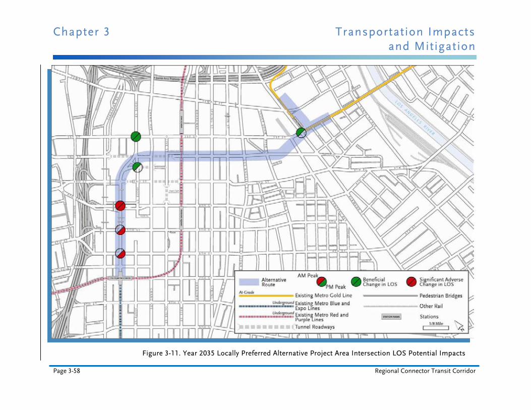
Chapter 3 Transportation Impacts and Mitigation
Page 3-58 Regional Connector Transit Corridor
Figure 3-11. Year 2035 Locally Preferred Alternative Project Area Intersection LOS Potential Impacts
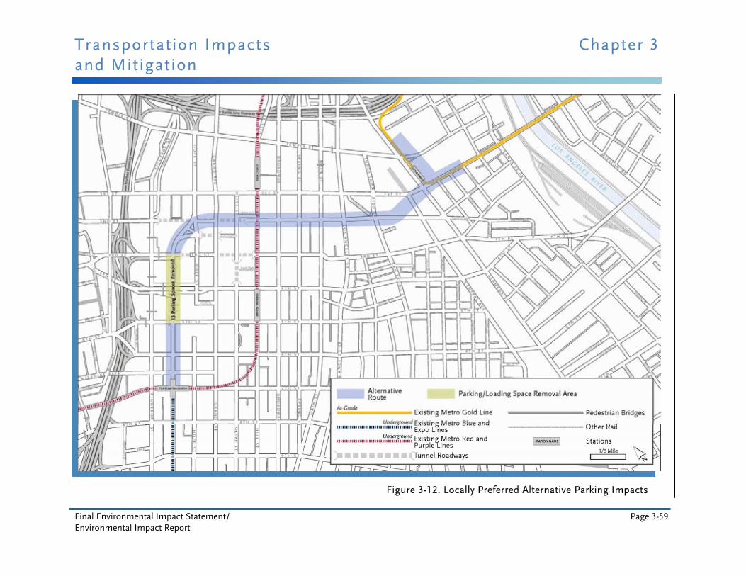
Transportation Impacts Chapter 3 and Mitigation
Final Environmental Impact Statement/ Page 3-59 Environmental Impact Report
Figure 3-12. Locally Preferred Alternative Parking Impacts
Chapter 3 Transportation Impacts and Mitigation
Page 3-60 Regional Connector Transit Corridor
To mitigate the effects of street parking needing to be temporarily removed during construction:
To avoid impacts to neighborhood parking supplies, Metro shall require the contractor to designate areas for construction/contractor employee parking and shall not allow employees to park in other lots or unauthorized areas. Metro shall identify and implement measures to reduce the need for parking by construction workers, including carpool incentives, transit passes, or designated on-site or off-site parking. Metro shall direct construction workers not to park on the street. (TR-3)
Metro shall work with the City to develop a parking mitigation program to mitigate the loss of public parking spaces during construction. This would include, but is not limited to, restriping the existing street to allow for diagonal parking, reducing the number of restricted parking areas, phasing construction activities in a way that minimizes parking disruption, and increasing the time limits for on-street parking. Restriping would occur on portions of Temple Street, Alameda Street, 1st Street, 2nd Street, Central Avenue, San Pedro Street, Judge John Aiso Street, 3rd Street, and Traction Avenue. Such parking mitigation shall be implemented on a temporary, tiered basis pending findings of the annual parking analysis described in EJ-11 in the MMRP for the LPA, Chapter 8, of this Final EIS/EIR. (DR-4)
Metro shall not hinder access to other public parking lots during construction. (DR-5)
To mitigate the effects of rerouting pedestrian and bicycle traffic during construction:
Safe pedestrian detours with handrails, fences, k-rail, canopies, and walkways shall be provided as needed. When a crosswalk is closed due to construction activities, pedestrians shall be directed to nearby alternate crosswalks. Access shall be ADA accessible at all times per existing Metro policy.(TR-4)
Bicyclists shall be encouraged through signage to ride carefully in streets near construction activities, ride carefully on sidewalks (as City of Los Angeles municipal code permits), or choose nearby alternate routes around construction sites. Detours shall be provided as needed. Metro shall provide signage showing the alternate bicycle routes. Pedestrian and bicycle circulation, and travel lanes temporarily impacted during construction shall be restored to their permanent configurations at the conclusion of the construction period and prior to operations. (TR-5)
To mitigate the permanent reductions in intersection performance on Flower Street from 4th Street to 6th Street:
At the intersection of 4th and Flower Streets, Metro, in coordination with LADOT, shall permanently restripe the southbound Flower Street approach to provide one shared left-turn/through lane and two through lanes. Metro, in coordination with LADOT, shall also optimize the signal splits. (TR-6)
At the intersection of 5th and Flower Streets, Metro, in coordination with LADOT, shall permanently restripe the southbound Flower Street approach to provide three through lanes
Transportation Impacts Chapter 3 and Mitigation
Final Environmental Impact Statement/ Page 3-61 Environmental Impact Report
and one exclusive right-turn lane. Metro, in coordination with LADOT, shall also optimize the signal splits. (TR-7)
At the intersection of 6th and Flower Streets, Metro, in coordination with LADOT, shall permanently restripe the eastbound 6th Street approach to provide three through lanes and two exclusive right-turn lanes. Metro, in coordination with LADOT, shall also optimize the signal splits. (TR-8)
To mitigate the effects on shuttle bus drop-off areas for City National Plaza during construction:
Metro shall ensure that shuttle bus drop-off areas at City National Plaza are provided throughout construction. (TR-9)
To ensure the project’s connectivity with other transit lines and pedestrian systems:
Metro shall design and implement linkages with the proposed streetcar project and Bringing Back Broadway project at the 2nd/Broadway station. The project shall also provide a knockout panel to the west side of Flower Street at 3rd Street to connect to the pedestrian system previously designed by the City of Los Angeles. (TR-10)
Metro shall construct an enhanced pedestrian walkway along the east side of Flower Street between 4th and 7th Streets to better connect the Financial District to the improved transit services available at the existing 7th Street/Metro Center Station. (TR-11)
To mitigate the restriction of access to some bus stops in the project area during construction:
Metro shall maintain access to bus stops and provide adequate signage to guide bus users to accessible stops. Metro shall minimize temporary closures or relocations of bus stops and layover zones. Metro shall provide notices of closures and relocations on its website, smart phone apps, and other modes typically used to communicate service announcements. When closures of other bus operators' stops are needed, Metro shall work closely with the affected operators to provide notices. (TR-12)
To mitigate the effects of temporarily relocating some bus stops in the project area during construction due to street closures and detours around construction areas:
As needed, Metro shall temporarily relocate bus stops to nearby alternative locations based on the re-routing of bus service, and provide adequate signage and notices at strategic locations indicating the relocated bus stops. Metro shall provide notices of relocations on its website, smart phone apps, and other modes typically used to communicate service announcements. Metro shall coordinate with municipal transit providers to temporarily relocate non-Metro bus stops. When bus re-routing is necessary, buses shall be re-routed to adjacent streets in a manner that minimizes inconvenience to bus passengers and to affected neighborhoods. (TR-13)
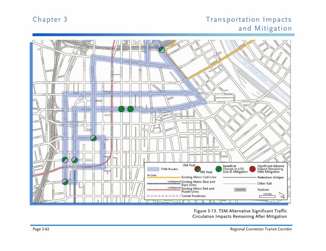
Chapter 3 Transportation Impacts and Mitigation
Page 3-62 Regional Connector Transit Corridor
Figure 3-13. TSM Alternative Significant Traffic Circulation Impacts Remaining After Mitigation
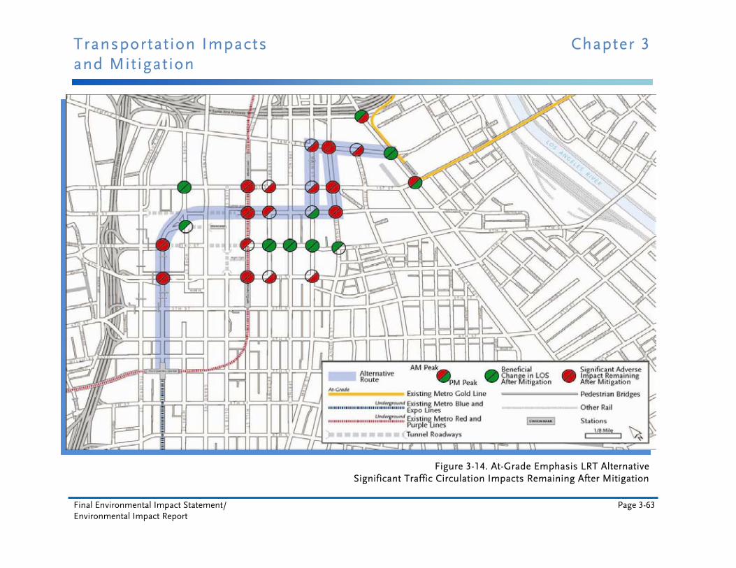
Transportation Impacts Chapter 3 and Mitigation
Final Environmental Impact Statement/ Page 3-63 Environmental Impact Report
Figure 3-14. At-Grade Emphasis LRT Alternative Significant Traffic Circulation Impacts Remaining After Mitigation
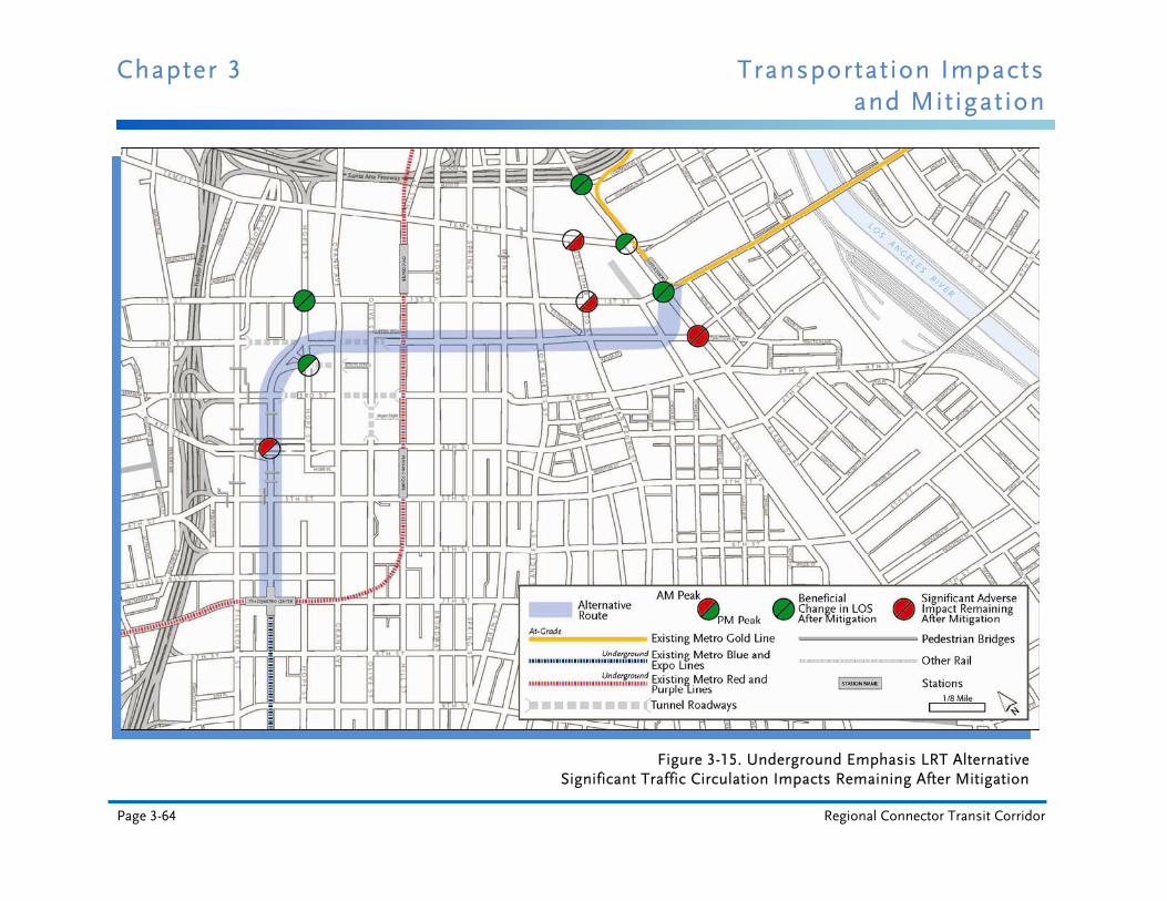
Chapter 3 Transportation Impacts and Mitigation
Page 3-64 Regional Connector Transit Corridor
Figure 3-15. Underground Emphasis LRT Alternative Significant Traffic Circulation Impacts Remaining After Mitigation

Transportation Impacts Chapter 3 and Mitigation
Final Environmental Impact Statement/ Page 3-65 Environmental Impact Report
Figure 3-16. Locally Preferred Alternative
Significant Traffic Circulation Impacts Remaining After Mitigation