Celebrating - Mahu Whenua · back to around 1300 AD when Ma-ori first travelled through the land....
7
QEII National Trust Celebrating the Mahu Whenua covenants The Mahu Whenua covenants were established by Robert ‘Mutt’ Lange of Soho Property Limited in partnership with Queen Elizabeth II National Trust. They were formally opened on 7 March 2015 by the National Trust’s Patron, His Excellency, Lt Gen The Rt Hon Sir Jerry Mateparae, GNZM, QSO, Governor-General of New Zealand.
Transcript of Celebrating - Mahu Whenua · back to around 1300 AD when Ma-ori first travelled through the land....

QEII National Trust
Celebrating the Mahu Whenua covenants
The Mahu Whenua covenants were established
by Robert ‘Mutt’ Lange of Soho Property Limited in
partnership with Queen Elizabeth II National Trust. They
were formally opened on 7 March 2015 by the National
Trust’s Patron, His Excellency, Lt Gen The Rt Hon Sir Jerry
Mateparae, GNZM, QSO, Governor-General of New Zealand.
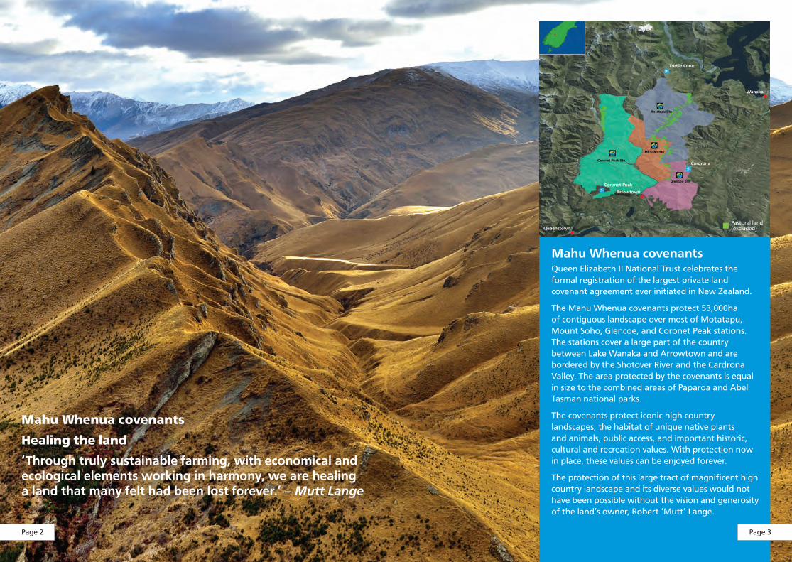
Mahu Whenua covenantsQueen Elizabeth II National Trust celebrates the formal registration of the largest private land covenant agreement ever initiated in New Zealand.
The Mahu Whenua covenants protect 53,000ha of contiguous landscape over most of Motatapu, Mount Soho, Glencoe, and Coronet Peak stations. The stations cover a large part of the country between Lake Wanaka and Arrowtown and are bordered by the Shotover River and the Cardrona Valley. The area protected by the covenants is equal in size to the combined areas of Paparoa and Abel Tasman national parks.
The covenants protect iconic high country landscapes, the habitat of unique native plants and animals, public access, and important historic, cultural and recreation values. With protection now in place, these values can be enjoyed forever.
The protection of this large tract of magnificent high country landscape and its diverse values would not have been possible without the vision and generosity of the land’s owner, Robert ‘Mutt’ Lange.
Mahu Whenua covenants
Healing the land
‘Through truly sustainable farming, with economical and ecological elements working in harmony, we are healing a land that many felt had been lost forever.’ – Mutt Lange
Pastoral land (excluded)
Page 2 Page 3

A landscape rich in native plant and animal life
Water catchment valuesMuch of the area has steepland soils that are liable to severe erosion. The gold rush in the 1860s, with its sluicing and watercourse alterations, has exacerbated natural erosion. To this day the Shotover River takes in a high sediment load, which intensifies flooding in the Clutha River. Tall tussock density and woody species cover is increasing and should slow down erosion over time.
The natural vegetation cover plays a vital role in soil and water conservation and yield. Many people in the Kawarau and Clutha catchments rely on these natural services for their livelihood, for drinking water, and for recreation and tourism.
The outstanding values of the Shotover catchment were recognised in 1977 under the Kawarau Water Conservation Order, which specifically highlights the catchments’s wild and scenic features, natural character, scientific values, recreational values for rafting, kayaking and jet boating, and its rich historical fabric.
The covenants’ shrublands and forests are habitat for grey warblers/riroriro, silvereye (or waxeye)/tauhau, riflemen/titipounamu, fantails/pı-wakawaka, bellbirds/korimako, and tomtits/ngirungiru, which are preyed upon by the Eastern falcon/ka- rearea.
The South Island oystercatcher/to- rea, spur-winged plover, harrier hawk/kahu, and paradise shelduck/pu- tangitangi utilise much of the covenanted areas. Kea frequent the Harris Mountain tops and New Zealand pipit/pı-hoihoi are widespread in grassland areas. Skinks/mokomoko live in amongst the tussocks and rocks.
Alpine zones are habitat for regionally endemic insect species and those typical of south-eastern South Island. Tussockland areas are particularly insect rich. Species found in the area include Hamilton’s Mountain Black butterfly (Pernodaimon micans), the pink and green Meterana meyricci – a moth that feeds on Pimelea, the giant ghost moth (Aoraia aurimaculata), the rare butterfly Erebiola butleri, colourful grasshoppers, flightless stoneflies, and giant dragonflies.
Vegetation communitiesCushionfields dominate the harshest sites in the alpine zones. Snowbank plant communities occur where snow lies for extended periods. Slim snow tussock (Chionochloa macra) is found above 1400–1500m. Narrow-leaved snow tussock (Chionochloa rigida) dominates below 1500m.
Short tussocklands dominated by hard tussock (Festuca novae-zelandiae) are found between 900–1000m.
Wetlands form as bogs in the alpine zone, as seepages in tussocklands, and as ephemeral tarns in the montane zone and along river and stream edges.
Grey shrublands are dominated by tree daisies (Olearia species) and mingimingi (Coprosma propinqua). Mountain ribbonwood (Hoheria lyallii) is largely confined to gullies below 1000m.
Mountain beech forest remnants with occasional silver and red beech are common in the Motatapu Valley.
Page 4 Page 5

A landscape with a rich history Highly intact heritage sites are spread across this land, evidence of the layers of human history that have moved across it. Sites date back to around 1300 AD when Ma- ori first travelled through the land. The activities of these first explorers are revealed in old trails, umu (ovens), rock art, rock shelters, and taonga (artefacts) that have been found.
In the 1850s, Pa- keha- surveyors arrived, establishing survey marks on high tops such as the stone cairn present on Vanguard Peak.
Next came the pastoralists bringing with them sheep and cattle. They used Ma- ori tracks to travel through the landscape. They also created their own trail networks. Other evidence left by these pastoralists since the 1860s includes historic fence lines, exotic plantings, musterers’ huts, and homestead remains.
In 1862, gold was discovered on the Arrow and Shotover rivers. Although the pastoralists were informed of gold by Ma- ori working for them, this was kept quiet for fear of losing the land to mining. This loss of control to gold mining, however, was inevitable. The land was soon teaming with gold miners seeking their fortunes. Pa- keha- miners initially dominated the mining operations. Chinese miners began to arrive from Australia in 1865 and by 1869 directly from China. Gold mining continued in a more limited capacity into the 1920s and 1930s including large sluicing operations at Muddy Terrace and on Motatapu, and hard rock mining at Macetown. Mining heritage sites dominate the archaeological landscape of the covenanted areas and, because of the isolated nature of these sites, they are well preserved and can be easily identified and understood.
Page 6 Page 7

A landscape to enjoyWith permanent protection in place, permanent public access is also assured at a number of sites. The Department of Conservation’s Motatapu Tramping Track crosses some of the land. This track forms part of Te Araroa, New Zealand’s ‘Long Pathway’, which runs the length of the country. Four–wheel–drive trips, mountain biking, tramping, horse trekking and ski touring are other activities that can be enjoyed forever amid this iconic high country landscape.
Trails for the futureThe creation of the Mahu Whenua covenants is not the only major development on Motatapu, Mount Soho, Glencoe, and Coronet Peak stations. Lease owner, Soho Property Limited, has also been working with the New Zealand Walking Access Commission and the Commissioner for Crown Lands to formalise up to 21 new trails for the public to enjoy. This process is being undertaken to meet Overseas Investment Act 2005 purchase conditions and will help to safeguard enduring public access to some of the most spectacular high country in the Southern Lakes region. Soho Property Limited has been supportive and has generously agreed to establish four entirely new trails over and above those required of it under its Overseas Investment Act conditions of purchase. Once the trails have been formalised, the National Trust will assume management responsibility for them as the designated controlling authority. The Queenstown Lakes District Council and the Department of Conservation will work closely with the Trust to manage the trails. All of the trails will be on Glencoe and Coronet Peak stations, making them easily accessible from Queenstown and providing opportunities for walking, mountain biking, horse riding, and appreciation of the area’s rich scenery, history, and culture. They complement and will connect up with the section of Te Araroa that passes through Motatapu and Mount Soho stations.
Page 8 Page 9

The Motatapu EventOver the years the Motatapu Event has earned the reputation of being ‘a bucket–list race’ situated amid some of the most stunning scenery in the world. The Queenstown Trails Trust celebrates its relationship with Soho Property Limited, which supports the Motatapu Event and allows special access to otherwise private sections of its property for it.
In 2014, the event celebrated 10 successful years under the ownership of the Queenstown Trails Trust. The annual event was established in 2005 with a mountain bike and marathon race attracting 1,300 participants. Now close to 5,000 participants take part in five different events, all held on the same day, with the majority traversing a route that is only open to the public one day a year for the event. Races include the Speights 47km Mountain Bike (the most popular event), Icebreaker Off-Road Marathon, Arrowtown.com 15km Miners Trail, XTERRA UDC Finance Triathlon, and the Torpedo7 51km Adventure Run. Lagardère Limited currently manage the event on behalf of the Queenstown Trails Trust.
‘Thank you for the chance to experience some of the most breath-taking landscape we have ever seen. It was awesome!’ – Jason Cronshaw, Motatapu Event participant.
Page 10 Page 11

Queen Elizabeth II National Trust was established in 1977. It is an independent statutory organisation and registered charity that partners with private landowners to help them permanently protect special natural and cultural heritage sites on their land with covenants. The network of special places protected by landowners with QEII National Trust covenants continues to grow. It currently totals more than 180,000ha – an area similar in size to Rakiura/Stewart Island.
Contributions and references: Motatapu Mt Soho Conservation Plan prepared by Boffa Miskell Planning Design and Ecological Consultants, Department of Conservation – Conservation Resources reports for Coronet Peak and Glencoe stations, Rob Wardle – Queen Elizabeth II National Trust, Dr Matthew Schmidt – Heritage New Zealand/Pouhere Taonga, Gemma Boyle – Lagardère Limited (Motatapu Event organisers), James Heffield – New Zealand Walking Access Commission.
Photos: Cover Mount Soho Station/Stephen Jacquiery – ODT, page 2 Coronet Peak Station/Stephen Jacquiery – ODT, page 3 map/Erik Zydervelt – QEII National Trust, page 4 Kea/Bill Wallace – QEII National Trust, page 6 Historic hut/Mike Jebson – QEII National Trust, page 8 A landscape to enjoy/Rob Wardle – QEII National Trust, page 10 Motatapu Event mountain bikers/Jim Pollard.
QEII National Trustwww.openspace.org.nz
www.facebook.com/QEIINationalTrust
Protecting our precious placesPublished in 2015 by Queen Elizabeth II National Trust, 138 The Terrace, Wellington, New Zealand