CAMP WINNEBAGO - Camping | Patriots' Path Council ... north trail...CAMP WINNEBAGO The Winnebago Boy...
20
CAMP WINNEBAGO The Winnebago Boy Scout Historic Trail, (Northern Tour) is a 14.5 mile roundtrip hike. The hike begins in camp, leads to Four Corners, then to the old Wharton & Northern Railroad bed along the Charlotteburg Reservoir, follows the Susquehanna & Western Railroad bed, across Green Pond Road, to the northern terminus of the Four Birds Trail on the ridgeline of Green Pond Mountain, with a breathtaking view of Craigmeur Ski Center, down the mountain following the WHITE TRAIL, along the Copperas Mountain and back to camp.
Transcript of CAMP WINNEBAGO - Camping | Patriots' Path Council ... north trail...CAMP WINNEBAGO The Winnebago Boy...

CAMP WINNEBAGO
The Winnebago Boy Scout Historic Trail, (Northern Tour)
is a 14.5 mile roundtrip hike.
The hike begins in camp, leads to Four Corners, then to the
old Wharton & Northern Railroad bed along the
Charlotteburg Reservoir, follows the
Susquehanna & Western Railroad bed, across Green Pond
Road, to the northern terminus of the Four Birds Trail on
the ridgeline of Green Pond Mountain, with a breathtaking
view of Craigmeur Ski Center, down the mountain
following the WHITE TRAIL, along the Copperas
Mountain and back to camp.
THE BOY SCOUTS HISTORIC TRAIL
(Northern Tour)
DESCRIPTION: The Boy Scout Historic Trails are a walk back
in time to an era when this area of New Jersey opened its natural
wealth and beauty to early settlers. The Lenape Minsi Tribe were
the original settlers of this region. Perhaps you will walk some of
the same trails as they did in search of face-paint rock (iron oxide).
Hiking the Wharton & Northern Railroad bed along Charlotteburg
Reservoir, try to picture the 19
th
century tourists arriving by stage
or train in the Highlands of New Jersey for summer visits. Green
Pond Mountain affords a unique geological look at the area with
glacial boulders and Pre-Cambrian “Green Pond Conglomerate.”
Spring finds the trails fragrant with abundant mountain laurel.
Hiking the “Four Birds Trail” past Craigmeur you cross the valley
to the Copperas Mountains and return to camp.
QUALIFICATIONS: The Northern tour is a challenging hike
across 2 mountains and is not for the faint of heart or weak of
spirit. This trail has been designed for the Boy Scout program
and may be hiked by similar community groups. A group can hike
the trail in one or two days. Minimum suggested age for hiking the
trail is 11 years of age.
SCOUT REQUIREMENTS: All Boy Scouts MUST conform to
all normal requirements set by the Boy Scouts of America govern-
ing hiking. Wearing a uniform is not required. Pencils and a
compass are needed to fill out the questionnaire. A bag lunch and
dinner, water canteens and waterproof boots are recommended.
TRAIL REQUIREMENTS: A donation of $2.00 per booklet is
suggested at the start of the hike to cover the cost of the trail
package. For the Trail Award, there is a questionnaire with 25
informative fill-in questions. These are to be turned in to the group
leader at the end of the Trail in order to receive the award. Starting

time is between 8:00 AM and 10:00 AM. Units can select their
own starting time, but must report to the Campmaster 30 minutes
prior to this time. Scouts outside of Patriots’ Path Council are
required to have a valid tour permit. Hikers should wear shoes and
clothing appropriate to a backwoods trail running through the
Farny Highlands Trail Network. A marshy trail and several
streams must be crossed. “Be Prepared!”
TIME REQUIREMENTS: The trail can be hiked year round
depending on weather and trail conditions. Depending on skill
level, the hike is 8-10 hours.
TRAIL AWARDS: The Camp Winnebago Boy Scout Historic
Trail award patch can be purchased at the Camp Winnebago
Trading Post at the end of the hike.
REGISTRATION: Prior to hiking or camping, a day or weekend
reservation for Camp Winnebago must be made with the Patriots’
Path Council Service Center.
Newark Watershed Permit: use of Newark’s Pequannock
watershed is by permit only. Seasonal
NWCDC (M-F 9-5) NWCDC (M-F 8-4; Sat. 8-1)
40 Clinton St. 4
th
Fl. 223 Echo Lake Rd.
Newark, NJ 07102 PO Box 319
Tel. # 622-4521 Newfoundland, NJ 07435
Tel. # (973) 697-2850
Hiking Fees:
Newark Residents $.4.00 Non-Newark Residents $8.00
Newark Seniors $2.00 Non-Newark Seniors $4.00
OVERNIGHT CAMPING: Tent sites, lean-tos and cabins
are available for overnight camping at Camp Winnebago.
Information regarding fees and reservations may be obtained
from the Patriots’ Path Council Service Center.
ADDRESS: Camp Winnebago
Timberbrook Road, Rockaway, NJ 07866

TRAIL GUIDE: HISTORIC TRAIL
The Camp Winnebago Boy Scout Historic Trail
begins at the parade field opposite the “A”
(Administration) building. When your group is ready,
begin your hike by walking north-west on the camp
road. The sites at Camp Winnebago are named after
Native American tribes with the Lenape representing
the local area.
QUESTION 1: NAME THE LENAPE TRIBE &
THEIR TOTEM IDENTIFIED WITH “MEN OF
THE STONY COUNTRY.”
QUESTION 2: NAME THE LENAPE TRIBE &
THEIR TOTEM IDENTIFIED WITH
“FISHERMEN.”
QUESTION 3: NAME THE LENAPE TRIBE &
THEIR TOTEM IDENTIFIED WITH “PEOPLE
LIVING NEAR THE OCEAN.”
Exit camp on Timberbrook Road; 50 ft. past the
entrance gate, hike North onto the dirt logging/fire road.
QUESTION 4: WHAT WERE THE RED ROCKS
THE LENAPE USED FOR FACE PAINT?
QUESTION 5: DESCRIBE HOW THE DUTCH
OUTWITTED THE LENAPE FOR LAND IN 1609.

Hike to Four Corners. Here the trail intersects with the
east/west bed of the old Wharton & Northern Railroad.
Look for foundations of a railroad bridge over the stream
to the west. Hike north and then east on the Road.
QUESTION 6: WHERE ARE THE LENAPE
TRIBES TODAY?
The logging/fire road again intersects with the
Wharton & Northern Railroad bed. Follow the railroad
bed north with the Charlotteburg Reservoir to the east.
QUESTION 7: NAME THE HOTEL LOCATED
IN THE CHARLOTTEBURG SECTION OF
WEST MILFORD.
QUESTION 8: WHY WAS THE TOWN OF
CHARLOTTEBURG BURNED?
QUESTION 9: NAME THE WINTER INDUSTRY
THAT WAS A SPINOFF OF HOTELS.
The Wharton & Northern Railroad bed intersects the
active line of the Susquehanna & Western Railroad at the
northern end of Charlotteburg Reservoir. Hike west on
the road next to the track. The railroad bends north/west
then begins a straight-a-way which parallels highway
Route 23.

QUESTION 10: USING SCOUT TECHNIQUES,
MEASURE THE DISTANCE FROM THE TURN
TO THE MOST DISTANT POINT OF TRACK.
QUESTION 11. WHAT WAS THE EARLY PATH
OF HIGHWAY ROUTE 23?
QUESTION 12: WHO WAS THE PRESIDENT OF
THE NJ MIDLAND RAILROAD?
Hike west, cross Green Pond Road, and hike on
Bigelow Road past the railroad station.
QUESTION 13: WHAT IS THE NAME
OF THE STATION?
QUESTION 14: NAME THE RAILROAD LINE
FOR THE PARKED TRAIN.
Pass the ball field and apartments to the end of the
blacktop road and a 2 car parking area. Uphill and
into the woods is the trail-head of the “Four Birds”
(WHITE TRAIL). One mile north on Rt. 23 is the
Village Square Inn.
QUESTION 15: WHAT WAS THE VILLAGE
SQUARE INN ORIGINALLY?

Hike the “Four Birds” (WHITE TRAIL) south on
Green Pond Mountain. There is a unique rock type
associated with this geological formation. Look for rock
containing “subangular pebbles of white quartz in dull
red quartz sandstone.”
QUESTION 16: NAME AND COLLECT A SAMPLE
OF THE UNIQUE ROCK.
QUESTION 17: HOW OLD IS
PRE-CAMBRIAN ROCK?
At the overlook (large rock formation) there is a
spectacular view of the valley and the Copperas
Mountain. The trail descends into the valley. The rock
overhangs and shelters a small area. Stand on the
overlook rock.
QUESTION 18: TAKE A COMPASS BEARING ON
THE TOWER TO THE NORTH/EAST.
QUESTION 19: TAKE A COMPASS BEARING ON
THE TOWER TO THE SOUTH/EAST.
Hike the WHITE TRAIL crossing a stream on the
descent and again on the valley floor. The trail joins a
logging/fire road and the road intersects a power-line
road that you follow north. (following the road to the
south/west will bring you to Green Pond).
Remain on the WHITE TRAIL.

QUESTION 20: HOW WAS GREEN POND
FORMED AND WHAT ARE ITS DIMENSIONS?
QUESTION 21: NAME THE 3 TURN OF THE
CENTURY GREEN POND HOTELS.
Watch for the WHITE TRAIL to enter the woods
at the bottom of the hill. There was an old picnic table
in a small meadow. You will cross and recross streams.
One has a log bridge. The Craigmeur Ski area will be
to the east.
QUESTION 22: WHY IS CRAIGMEUR NO
LONGER USED FOR SKIING?
Hiking this area on a Sunday morning you will be
treated to melodies from a nearby house of worship.
QUESTION 23: IDENTIFY THE HOUSE
OF WORSHIP.
Crossing a dike, you will view old man -made dikes
and dams. However, research could not identify a name
or use. Carefully cross Green Pond Road and continue
following the WHITE TRAIL. The trail crosses a
logging/fire road and gently ascends the Copperas
Mountain. Charlotteburg Reservoir will become visible
to the east and the trail will follow the old logging/fire
road. The trail leaves the road and begins to descend the
mountain. Look for the microwave tower, this was
viewed earlier from Green Pond Mountain.
QUESTION 24: TAKE A COMPASS BEARING TO
THE MICROWAVE TOWER.
QUESTION 25: WHAT IS THE NAME OF THE
LAKE IN THE VALLEY YOU HAVE ENTERED?
The WHITE TRAIL will lead you across the old
Wharton & Northern railroad bed and beside a marshy
area now turned into a small pond by beaver damming.
The trail meets the original logging/fire road taken out of
camp. Hike the road south back to Timberbrook Road
and the entrance to Camp Winnebago.
TRAIL GUIDE HISTORIC INFORMATION
THE LENAPE TRIBES – (from: History, Manners, and Customs
of the Indians Nations. The Moravian missionaries, John
Heckewelder and David Zeisberger, reported that the Lenape, at
the time of the white man’s arrival, were divided into three distinct
“tribes”: The Minsi, or “Men of the Stony Countr,.” who had as
their totem the wolf, the Unami, the “Fisherman” of the central
area, who had as their totem the turtle, and the Unilachtigo, the
“People living near the ocean,” whose totem was the wild turkey.
RED FACE PAINT – In 1609, seaman Juet of Henry Hudson’s
ship the “Half Moon,” recalled shipmates inquiring of the natives
the source of the red paint on their faces. The Dutch, more than a
little interested in finding sources of minerals and other wealth,
may well have recognized the red as iron oxide. The Lenape are
said to have responded that the red was to be found on the shores
of the “long pond” (Greenwood Lake). Red rocks, iron oxide,
which the Lenape used to paint their faces, abounds in the
Northern Highlands area.
LENAPE TRICKED – (from: John Heckewelder, 1876) Returning
a year later, the Dutch, as they had communicated to the Lenape
upon leaving in 1609, requested a strip of land, only as much as
the hide of a bullock would cover, in order to grow greens. Their
request granted, however, the white men then proceeded to cut
the hide, using a shape knife, into one continuous strip “no
thicker than a child’s finger.” This, when stretched out into a
circular shape, encompassed a large area. Though outwitted,
the Lenape are said to have protested little. With more than
enough land for themselves, they could easily yield some to
the newcomers.

LENEPE LEGACY – By the time of the French & Indian war, the
main Lenape villages had already relocated on the Pennsylvania
frontier, along the Susquehanna. By 1758 most of the Lenape had
withdrawn beyond the Alleghany Mountains. Following the
decisive battle of Fallen Timbers, the Lenape were forced to sign
the Treaty of Greenville (1795) which granted to the Delaware
land in what was later to become northern Ohio, Indiana, Illinois,
Michigan and Wisconsin. But the sorrowful story of the Delaware
does not end on the Wabash in Indiana or even in upper Canada,
where the Monsey band in particular settled. As on e by one each
treaty was voided by the restless pioneers of a new nation, the
Lenape found their way to Oklahoma, where they became
Cherokee citizens. Although their blood is said to run through
those of mixed Indian ancestry in Oklahoma and in parts of
Canada, today there are no full-blooded Lenape living.
J.H. HALLOWAY’S HOTEL – Located in the Charlotteburg
section of West Milford, the hotel offered 30 rooms for the
convenience of city vacationers. The highlands of New Jersey,
once a region of prosperous iron mines, were now overwhelmed
by the new discoveries of iron along Lake Michigan. The new
settlers to the region were shopkeepers and hotel owners who
touted the area as being closer than the Adirondacks, peaceful,
without mosquitoes and malaria. Prices ranged from $2.50 a day
to $7 - $8 per week.
CHARLOTTEBURG IN FLAMES – (from: The Earth Shook and
The Sky Was Red, A Bicentennial History of West Milford).
Charlotteburg in 1871 could boast a post office, 35 homes, a
rolling mill, forge, saw mill, machine shop, blacksmith shop, and
schoolhouse. Residents were awaiting eagerly the first New Jersey
Midland Railroad passenger train. But 26 years later,
Charlotteburg was in flames. Its population had dwindled with the

demise of the ice industry and the end of the era of the great hotels.
Newark, which owned the land on whi ch the hamlet was
located, was concerned with the continuing pollution of the
Pequannock River by the Hennion house and barn. And so the
decision was made; Charlotteburg, with the exception of one
house, a hotel, a barn, and a schoolhouse, would be demolished.
On August 25, 1897, nearly all of Charlotteburg was burned to the
ground. A year later, even the nearby school was closed by order
of the superintendent of schools, and again because of sanitary
problems. By 1912, there were only 40 residents left in the nearby
area, and by 1928, the area could only be described as “deserted.”
ICE CUTTING DAYS – (from North Jersey Historical Society,
by Leslie l. Post) “ The days had been clear and cold with early
morning temperatures below zero for about ten days, when the
word went across the Valley and up the ridges that ice cutting
would start in the morning. Cutting ice was a big business in
North Jersey with huge icehouses at Greenwood lake, Echo Lake,
Brady’s Pond (Lake Gerard) Summit Lake and numerous smaller
ice houses on the mill ponds for the local hotel’s summer use.”
Ice cutting became an important spin-off industry from the
summer tourist trade.
“The ice had to be at least 10 inches before it was cut, and some
years got as thick as 30 inches. If the ice was clear, cutting would
start at daybreak and go on till dark and even later on moon lit
nights. If it had snowed, the ice had to be plowed before it could
be cut. The ice was cut in 16 x 24 inch cakes with a steel plow
drawn by a single horse and another up and down and back and
forth until an area of about 12 to 16 cakes wide and 30 to 40 cakes
long was marked or cut halfway through. This area would then be
sawed by hand all the way through and floated down a channel, to

the icehouse. The cakes were pushed onto a conveyor which would
in turn carry them into the icehouse where the cakes were crossed
stacked. A layer of salt hay would be placed between the ice and
walls of the icehouse and also over the top of the ice to keep all
warmth out.”
THE PETERSON & DECKERTOWN STAGE LINE – (from The
Earth Shook). The stage line began its scheduled runs on May 1,
1857. The stages left Paterson on Monday, Wednesday, and
Friday, meeting the 8:30 AM train from New York. Nearly 10
hours were allowed for the trip to Deckertown (in Sussex County)
with stops at Preakness, Pompton, Bloomingdale, Newfoundland,
Stockholm and Hamburg. The return trips were made on Tuesday,
Thursday and Saturday. Route 23 follows the early path of the
Paterson & Deckertown Stage Line.
THE NEW JERSEY MIDLANDS RAILROAD – (from The Earth
Shook). On May 1, 1869, a meeting was held at Brown’s Hotel
(Newfoundland) to consider extending the (NJ Hudson &
Delaware Railroad) line to Newfoundland. A year later the NJ
H&D merged with the New Jersey & Western to form the NJ
Midlands Railroad. In early 1871, the NJ Midland pushed up the
valley toward Charlotteburg, but difficult terrain slowed the
construction. Heavy fill was needed, deep cuts had to be made,
and a bridge 50 feet above the water was to be constructed. It is
not clear as to exactly when the line was completed, but in 1887
a short stretch of track called the Macopin line was finished.
The 1 ½ mile road serviced the ice industry and carried tourists
to Echo Lake. US Vice President Garrett Hobart was president
of the line.
VILLAGE SQUARE INN – (from Village Square Inn, History).
This historical two-room Schoolhouse was built in the late
1880’s. It unique architectural lines and sky reaching steeple has

served as a visual landmark for nearly 100 years. Local residents
and travelers alike have welcomed this sight as the entrance to
Northern New Jersey’s recreation areas. In the early days, many
school lunches of chicken soup were served from the large potbelly
stove as the children rested from learning the 3 R’s. The School
operated until the mid 1950’s, after nearly 65 years of teaching.
Later, the Board of Education used the building for its
administration offices. The Village Square Inn opened in 1980.
GREEN POND CONGLOMERATE – (from: Geology and
Magnetite Deposits of Dover District, Morris County, NJ) of the
Silurian age crops out on both Copperas and Green Pond
Mountains on the northwest side of the Dover District, where it
directly overlies rocks belonging to the pre-Cambrian. Green Pond
conglomerate rests disconformably upon eroded surface of the pre-
Cambrian rocks, and at several places is exposed within a distance
of 25 or 30 feet of the pre-Cambrian, although it is not seen in
actual contact.
The Green Pond conglomerate, for the most, part is a red to
gray course-grained conglomerate that contains subangular
pebbles of white quartz in a matrix composed of dull-red quartz
sandstone, but parts of the formation are considerably different.
The basal part of the conglomerate at any places is a gray or
greenish conglomerate, and the upper part commonly is a purple-
red quartzite. Green Pond Conglomerate is specific to this
geographic location, and discovery otherwise is the result of glacial
movement.
GREEN POND – The lake was formed by a glacier and is 2 ½
miles long and ½ mile wide. There are no major streams entering
the lake; the lake is fed by mountain runoff and underground
springs. The average depth measured in 1953 was 14 feet while
a 1972 study gave a figure of 13 feet. The pond holds its level

by virtue of a heavy clay seal below its sandy and rock bottom
areas. When the glacier passed through this area, it left two
specific evidences: first, glacial till and gravel, mounds of mixed
materials and stones that are found along much of its easterly
shore, and second, the extensive relatively flat area at the northern
end of the lake.
GREEN POND – (from Historic Tour of Rockaway Township) -
The community of Green Pond is built around the largest body of
water in Rockaway Township. In the early 1700’s the first settlers
in this area were the Cobb family, whose business interests were
tied into the Split Rock Furnace and the Cobb Iron Mine. The
Green Pond mines were opened in 1872, and were worked until
1899 when they were abandoned because of an unfavorable ore
market. In the early 1900’s, the community of Green Pond began
to emerge as a summer vacation area. The early tent community
gave way to summer bungalows. Summer supplies could be
ordered at the general store and delivered by horse drawn buggy.
Three hotels catered to vacationers who came for dancing, tennis,
croquet, bowling, boating, fishing, swimming, and horseback
riding in the country. The Green Pond Hotel was built in 1905
and could accommodate 100 guests. Guests could expect hot and
cold water baths and running water. The hotel was heated by
steam heaters and open fires and was lighted by acetylene gas. In
1924 you could enjoy a delicious meal in the dining room for
$1.50. Guests to this hotel dwindled in the 1950’s and it was
demolished in 1961. The Davenport Hotel, was also torn down.
The Lake End Hotel still stands as a private residence.
CRAIGMEUR – (from Craigmeur Recreation Complex) Today
Craigmeur is a recreation complex on 50 acres, specializing in
company and group picnics. Among the many activities and
facilities are: 2 softball fields, 6 tennis courts, 6 volleyball courts,
flume ride, bumper boats and pony rides.
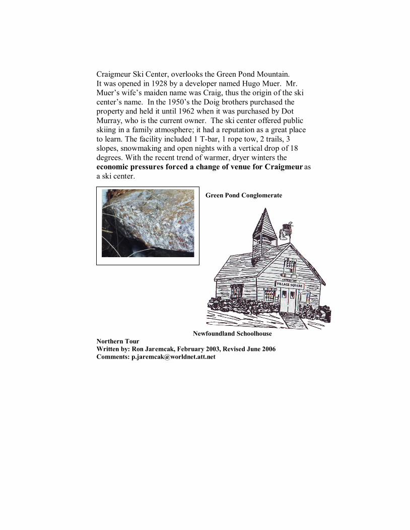
Craigmeur Ski Center, overlooks the Green Pond Mountain.
It was opened in 1928 by a developer named Hugo Muer. Mr.
Muer’s wife’s maiden name was Craig, thus the origin of the ski
center’s name. In the 1950’s the Doig brothers purchased the
property and held it until 1962 when it was purchased by Dot
Murray, who is the current owner. The ski center offered public
skiing in a family atmosphere; it had a reputation as a great place
to learn. The facility included 1 T-bar, 1 rope tow, 2 trails, 3
slopes, snowmaking and open nights with a vertical drop of 18
degrees. With the recent trend of warmer, dryer winters the
economic pressures forced a change of venue for Craigmeur as
a ski center.
Green Pond Conglomerate
Newfoundland Schoolhouse
Northern Tour
Written by: Ron Jaremcak, February 2003, Revised June 2006
Comments: [email protected]

Charlotteburg
Reservoir Dam at Rt. 23
Looking north.
Charlotteburg Reservoir Dam
(newly constructed) eastern
branch of reservoir with
Copperas Mt. in background
Susquehanna & Western RR
between Charlotteburg Reservoir
and Wharton & Northern RR bed.
“A” Building,
where it all
BEGINS.
CAMP WINNEBAGO
BOY SCOUT HISTORIC TRAIL ANSWER SHEET
The trail questions can be found in the trail guide. The trail guide must be followed closely,
both to show you the trail and where to find the answers to the questions. YOU WILL NEED
A COMPASS AND PENCIL. Fill in your answers in the following blank lines.
1. _____________________ ________________
2. _____________________ ________________
3. _____________________ ________________
4. ________________________________________________
5. ________________________________________________
________________________________________________
6. ________________________________________________
7. ________________________________________________
8. ________________________________________________
9. ________________________________________________
10. ________________________________________________
11. ________________________________________________
12. ________________________________________________
13. ________________________________________________
14. ________________________________________________
15. ________________________________________________
16. ________________________________________________
17. ________________________________________________
18. ________________________________________________
19. ________________________________________________
20. _______________ _______________ ______________
21. ________________________________________________
22. ________________________________________________
23. ________________________________________________
24. ________________________________________________
25. ________________________________________________
Patiots’ Path Council, BSA.
222 Columbia Turnpike, Florham Park, New Jersey 07832
www.ppbsa.org