Assimilation of T-TREC-retrieved wind data with...
15
Assimilation of T-TREC-retrieved wind data with WRF 3DVAR for the short-term forecasting of typhoon Meranti (2010) near landfall Xin Li, 1 Jie Ming, 1 Yuan Wang, 1 Kun Zhao, 1 and Ming Xue 2 Received 11 April 2013; revised 30 August 2013; accepted 4 September 2013; published 18 September 2013. [1] An extended Tracking Radar Echo by Correlation (TREC) technique, called T-TREC technique, has been developed recently to retrieve horizontal circulations within tropical cyclones (TCs) from single Doppler radar reflectivity (Z) and radial velocity (V r , when available) data. This study explores, for the first time, the assimilation of T-TREC-retrieved winds for a landfalling typhoon, Meranti (2010), into a convection-resolving model, the WRF (Weather Research and Forecasting). The T-TREC winds or the original V r data from a single coastal Doppler radar are assimilated at the single time using the WRF three-dimensional variational (3DVAR), at 8, 6, 4, and 2 h before the landfall of typhoon Meranti. In general, assimilating T-TREC winds results in better structure and intensity analysis of Meranti than directly assimilating V r data. The subsequent forecasts for the track, intensity, structure and precipitation are also better, although the differences becomes smaller as the V r data coverage improves when the typhoon gets closer to the radar. The ability of the T-TREC retrieval in capturing more accurate and complete vortex circulations in the inner-core region of TC is believed to be the primary reason for its superior performance over direct assimilation of V r data; for the latter, the data coverage is much smaller when the TC is far away and the cross-beam wind component is difficult to analyze accurately with 3DVAR method. Citation: Li, X., J. Ming, Y. Wang, K. Zhao, and M. Xue (2013), Assimilation of T-TREC-retrieved wind data with WRF 3DVAR for the short-term forecasting of typhoon Meranti (2010) near landfall, J. Geophys. Res. Atmos., 118, 10,361–10,375, doi:10.1002/jgrd.50815. 1. Introduction [2] Accurate prediction of the track, intensity, structure and precipitation of landfalling tropical cyclones (TCs) is crucial for the protection of life and property. In the past years, TC track forecasting has improved steadily [Rappaport et al., 2009] with significant contributions from satellite or other nontraditional observations and improved numerical models, but the intensity and structure forecasting has improved much more slowly [Houze et al., 2007]. One of the primary reasons is that the inner-core structures of TC are often inadequately initialized in operational models, while such structures are believed to be important for intensity forecasting. [3] Many efforts have been made to improve the initial con- ditions focusing on the data assimilation (DA) by using differ- ent types of observations from various platforms. Assimilating typhoon bogus data has been shown to result in much better intensity forecast [e.g., Zou and Xiao, 2000; Xiao et al., 2009a]. Such a method relies significantly on the empirical profiles of sea-level pressure (SLP) and/or wind assumed in the bogus vortex and therefore cannot represent the true TC structure. Studies have shown that the assimilation of satellite wind and aircraft dropsonde data helps to improve the environ- mental conditions and track forecast of TCs [Pu et al., 2008; Chou et al., 2011]. Among the various observational plat- forms, Doppler radar is the only platform that can observe the three-dimensional structure of TCs with high temporal and spatial resolutions. The airborne Doppler radar data have been shown to allow for the analyses of the inner-core struc- ture of TCs, especially during their lifetime over the ocean, which lead to improve track as well as intensity forecasting [Pu et al., 2009; Xiao et al., 2009b; Du et al., 2012; Weng and Zhang, 2012]. For landfalling TCs, coastal ground-based Doppler radars are commonly used for TC monitoring and forecasting. Several recent studies have shown that the direct assimilation of radar radial velocity (V r ) data into cloud- resolving numerical models can improve TC analysis and forecasting [e.g., Xiao et al., 2005; Zhao and Xue, 2009; Zhang et al., 2009; Dong and Xue, 2012]. All the studies cited above use either three-dimensional variational (3DVAR) or ensemble Kalman filter (EnKF) method for data assimilation. Compared with EnKF, 3DVAR is more computationally 1 Key Laboratory of Mesoscale Severe Weather/MOE and School of Atmospheric Sciences, Nanjing University, Nanjing, China. 2 Center for Analysis and Prediction of Storms, and School of Meteorology, University of Oklahoma, Norman, Oklahoma, USA. Corresponding author: J. Ming, Key Laboratory of Mesoscale Severe Weather/MOE and School of Atmospheric Sciences, Nanjing University, Nanjing 210093, China. ([email protected]) ©2013. American Geophysical Union. All Rights Reserved. 2169-897X/13/10.1002/jgrd.50815 10,361 JOURNAL OF GEOPHYSICAL RESEARCH: ATMOSPHERES, VOL. 118, 10,361–10,375, doi:10.1002/jgrd.50815, 2013
Transcript of Assimilation of T-TREC-retrieved wind data with...

Assimilation of T-TREC-retrieved wind data with WRF 3DVARfor the short-term forecasting of typhoon Meranti(2010) near landfall
Xin Li,1 Jie Ming,1 Yuan Wang,1 Kun Zhao,1 and Ming Xue2
Received 11 April 2013; revised 30 August 2013; accepted 4 September 2013; published 18 September 2013.
[1] An extended Tracking Radar Echo by Correlation (TREC) technique, called T-TRECtechnique, has been developed recently to retrieve horizontal circulations within tropicalcyclones (TCs) from single Doppler radar reflectivity (Z) and radial velocity (Vr, whenavailable) data. This study explores, for the first time, the assimilation of T-TREC-retrievedwinds for a landfalling typhoon, Meranti (2010), into a convection-resolving model, theWRF (Weather Research and Forecasting). The T-TREC winds or the original Vr datafrom a single coastal Doppler radar are assimilated at the single time using the WRFthree-dimensional variational (3DVAR), at 8, 6, 4, and 2 h before the landfall of typhoonMeranti. In general, assimilating T-TREC winds results in better structure and intensityanalysis of Meranti than directly assimilating Vr data. The subsequent forecasts for the track,intensity, structure and precipitation are also better, although the differences becomessmaller as the Vr data coverage improves when the typhoon gets closer to the radar. Theability of the T-TREC retrieval in capturing more accurate and complete vortex circulationsin the inner-core region of TC is believed to be the primary reason for its superiorperformance over direct assimilation of Vr data; for the latter, the data coverage is muchsmaller when the TC is far away and the cross-beam wind component is difficult to analyzeaccurately with 3DVAR method.
Citation: Li, X., J. Ming, Y. Wang, K. Zhao, and M. Xue (2013), Assimilation of T-TREC-retrieved wind data withWRF 3DVAR for the short-term forecasting of typhoon Meranti (2010) near landfall, J. Geophys. Res. Atmos., 118,10,361–10,375, doi:10.1002/jgrd.50815.
1. Introduction
[2] Accurate prediction of the track, intensity, structure andprecipitation of landfalling tropical cyclones (TCs) is crucialfor the protection of life and property. In the past years, TCtrack forecasting has improved steadily [Rappaport et al.,2009] with significant contributions from satellite or othernontraditional observations and improved numerical models,but the intensity and structure forecasting has improved muchmore slowly [Houze et al., 2007]. One of the primary reasonsis that the inner-core structures of TC are often inadequatelyinitialized in operational models, while such structures arebelieved to be important for intensity forecasting.[3] Many efforts have been made to improve the initial con-
ditions focusing on the data assimilation (DA) by using differ-ent types of observations from various platforms. Assimilating
typhoon bogus data has been shown to result in much betterintensity forecast [e.g., Zou and Xiao, 2000; Xiao et al.,2009a]. Such a method relies significantly on the empiricalprofiles of sea-level pressure (SLP) and/or wind assumed inthe bogus vortex and therefore cannot represent the true TCstructure. Studies have shown that the assimilation of satellitewind and aircraft dropsonde data helps to improve the environ-mental conditions and track forecast of TCs [Pu et al., 2008;Chou et al., 2011]. Among the various observational plat-forms, Doppler radar is the only platform that can observethe three-dimensional structure of TCs with high temporaland spatial resolutions. The airborne Doppler radar data havebeen shown to allow for the analyses of the inner-core struc-ture of TCs, especially during their lifetime over the ocean,which lead to improve track as well as intensity forecasting[Pu et al., 2009; Xiao et al., 2009b; Du et al., 2012; Wengand Zhang, 2012]. For landfalling TCs, coastal ground-basedDoppler radars are commonly used for TC monitoring andforecasting. Several recent studies have shown that the directassimilation of radar radial velocity (Vr) data into cloud-resolving numerical models can improve TC analysis andforecasting [e.g., Xiao et al., 2005; Zhao and Xue, 2009;Zhang et al., 2009; Dong and Xue, 2012]. All the studies citedabove use either three-dimensional variational (3DVAR) orensemble Kalman filter (EnKF) method for data assimilation.Compared with EnKF, 3DVAR is more computationally
1Key Laboratory of Mesoscale Severe Weather/MOE and School ofAtmospheric Sciences, Nanjing University, Nanjing, China.
2Center for Analysis and Prediction of Storms, and School ofMeteorology, University of Oklahoma, Norman, Oklahoma, USA.
Corresponding author: J. Ming, Key Laboratory of Mesoscale SevereWeather/MOE and School of Atmospheric Sciences, Nanjing University,Nanjing 210093, China. ([email protected])
©2013. American Geophysical Union. All Rights Reserved.2169-897X/13/10.1002/jgrd.50815
10,361
JOURNAL OF GEOPHYSICAL RESEARCH: ATMOSPHERES, VOL. 118, 10,361–10,375, doi:10.1002/jgrd.50815, 2013

efficient and suitable for operational use. However, 3DVARtypically does not analyze the cross-beam components of windwell from single Doppler radar radial velocity data especiallywhen it is not used in a cycled mode.[4] Instead of assimilating the original Vr data, assimilating
retrieved winds can be more effective. Zhao et al. [2011] ex-plored the assimilation of winds retrieved using the GBVTD(Ground-based velocity track display) [Lee et al., 1999] methodfor super typhoon Saomai (2006) near its landfall. The 3DVARassimilation of GBVTD-retrieved winds data resulted in betterstructure, intensity and precipitation analysis, and forecasts of
Saomai than direct assimilation of Vr data, partly becausethe GBVTD method can provide the full circle of vortex cir-culation in the inner-core region while Vr data coverage is of-ten incomplete. However, due to the geometric limitationimposed in GBVTD, the analysis domain is limited to the re-gion satisfying R/RT< 0.7, where R is the radius of the anal-ysis ring and RT is the distance of the TC center from theradar. In addition, for most operational radar, such as theWSR-88D of the U.S. and WSR-98D of China, the maxi-mum Doppler velocity range is about 230 km, far less thanthe maximum range of reflectivity, Z data, which is typically460 km. It would thus be advantageous if the reflectivity datacould be used to estimate the wind field to provide data cov-erage when the TC is further away from the coast.[5] Tuttle and Gall [1999] successfully retrieved TC circu-
lations using reflectivity data from two consecutive PlanPosition Indicator scans with the tracking radar echoes bycorrelation (TREC) method. Wang et al. [2011] developedthe so-called TC circulation TREC (T-TREC) technique byextending TREC to a polar coordinate centered at the TCcenter with the vortex rotating rate estimated from Vr dataas an extra retrieval condition. This condition providesa constraint on the searching range for spatial correlation inT-TREC algorithm and helps reduce the wind underestima-tion problem often encountered in the eyewall region wherethe reflectivity is often relatively uniform along the eyewallrainband [Tuttle and Gall, 1999]. This study explores for thefirst time the assimilation of T-TREC-retrieved wind datafrom a single radar located at Xiamen (XMRD) of FujianProvince, China, for typhoonMeranti (2010) that experienceda sudden intensification near the coast of China and broughtheavy rainfall to coastal Fujian and Zhejiang Provinces.The used data assimilation system is the WRF (WeatherResearch and Forecasting) 3DVAR [Barker et al., 2004].[6] Four pairs of data assimilation experiments are per-
formed, with each pair containing one experiment assimilatingVr data and one assimilating T-TREC data. These pairs ana-lyze for the single time of radar data at 1200, 1400, 1600, and1800 UTC, 9 September 2010, respectively. The 1200 UTCis the time when the inner-core region of typhoon Meranti firstmoved into the full coverage of XMRD reflectivity data butwas only partially covered by the radial velocity data. This isalso about the earliest time when T-TREC-retrieved wind re-trieval can be successfully performed. The other experimentsstarting at the later times examine the relative impacts ofT-TREC-retrieved winds versus Vr data when the typhoonwas closer to the radar to have better Vr coverage. To focuson the impact of the original Vr and the retrieved T-TRECwind data, all experiments excluded the assimilation of Z data.[7] The rest of this paper is organized as follows. Section 2
describes the radar data, forecastingmodel, assimilation system,and experimental configurations. Sections 3 and 4 examine theimpacts of assimilating Vr data versus T-TREC-retrieved windson the track, intensity, and structure forecasting of Merantiduring and after landfall; the results are compared to aforecast starting from the National Centers for EnvironmentalPredication operational Global Forecast System (GFS) analy-ses at 1200UTCwithout any radar data assimilation. Section 3discusses in detail the results from the 1200 UTC experiments,while section 4 presents results from the experiments withlater analysis times. Summary and conclusions are presentedin section 5.
Longitude (oE)
Longitude (oE)
Latit
ude
(oN
)La
titud
e (
oN
)
XMRD
Guangdong
Fujian
09/18
10/00
09/12
10/06
(a)
116 118 120
22
24
26
ms−1
−39
−33
−27
−21
−15
−9
−3
3
9
15
21
27
33
39
XMRD
Guangdong
Fujian
09/12
09/18
10/00
10/06
(b)
116 118 120
22
24
26
dBZ
5
10
15
20
25
30
35
40
45
50
55
60
65
70
75
Figure 1. The domain for radar data coverage at 1200UTC, 9 September, with the CMA best track locations ofTyphoon Meranti marked with 6 h interval from 1200UTC, 9 September to 0600 UTC, 10 September, 2010. (a)The Vr data (color shaded, m s�1) are shown, (b) the Z data(color shaded, dBZ) and the T-TREC-retrieved wind data(vectors) are shown, respectively at 3 km height. Small andlarge circles in both Figures 1a and 1b are the 230 km rangering of Vr data and 460 km range ring of Z data.
10,362
LI ET AL.: RADAR ASSIMILATION FOR TYPHOON

2. Method and Experimental Design
2.1. Radar Vr and T-TREC-Retrieved Wind Data
[8] In this paper, Level II data from XMRD radar are used,and the radar is located at the southeastern coast of China(Figure 1). Vr and Z data are edited manually using NationalCenter for Atmospheric Research Solo software [Oye et al.,1995] to remove/correct erroneous radar observations, includ-ing velocity dealiasing and ground clutters. The radial resolu-tions of the original XMRD radar data are 0.25 km for Vr and1 km for Z, respectively. The Vr data are thinned to a 4 km gridbefore assimilation. For T-TREC retrieval [Wang et al., 2011],quality controlled Z and Vr data are first interpolated to a gridwith 1 km horizontal and vertical grid spacings, then theretrieval is performed within a 300 km radius from the TC cen-ter, in cylindrical-polar coordinates. The T-TREC retrievalprocedure [Wang et al., 2011] as used in this study is brieflydescribed in the following.[9] As in the traditional TREC method, T-TREC uses Z data
from two consecutive scan times T1 and T2 (6min apart in thisstudy). The analysis divides each scan into the same number ofarc-shaped cells. Each cell from the first scan is cross-correlatedwith all possible cells in the second scan. The coefficient ρzis calculated by using the formula of Tuttle and Gall [1999],
ρz ¼∑N
k¼1Z1 kð ÞZ2 kð Þ � 1
N ∑N
k¼1Z1 kð Þ ∑
N
k¼1Z2 kð Þ
∑N
k¼1Z21 kð Þ � NZ1
2� �
∑N
k¼1Z22 kð Þ � NZ2
2� �� �1
2
; (1)
where Z1 and Z2 are Z arrays at T1 and T2, respectively, and Nis the number of data points within a cell.[10] To reduce the uncertainty produced by subjective se-
lection of searching area, the Vr is used to improve the esti-mation of the searching range and to create a velocitycorrelation coefficient. As the TC circulation exhibits a dis-tinct dipole pattern on Doppler radial velocity images andwith the TC circulation being modeled by a Rankine vortex[Brown and Wood, 1983], the mean tangential wind compo-nent VT(R) at each radius from TC center can be estimated by
VT Rð Þ ¼ V r max Rð Þ þj jV r min Rð Þj j2
; (2)
where R is the distance from the TC center, and Vrmax(R)
(Vrmin(R)) is the maximum (minimum) outbound (inbound)radial velocity. Therefore, a reference searching distance inthe azimuth direction DAref (OR as shown in Figure 2a) andthat in the radial direction DRref (half of AB as shown inFigure 2a) can be defined as
DAref ¼ VT Rð Þ�Δt; (3)
DRref ¼ α�VT Rð Þ�Δt: (4)
[11] Since the magnitude of radial flow is typically an orderof magnitude smaller than the tangential flow within a TC[Roux and Marks, 1996], parameter α is set to 0.3, as inWang et al. [2011]. Based on the reference searching dis-tance in the azimuth direction, an additional wind weightcoefficient ρv is defined as
ρv ¼1; DAref 1� βð Þ≤DA ≤DAref 1þ βð Þ0; others
�(5)
[12] Considering that the real tangential velocity may fluc-tuate around VT(R) and the axisymmetric component of tan-gential velocity is typically an order of magnitude largerthan the asymmetric component [Roux and Marks, 1996],β is used as an adjustable parameter and set to 0.3, as inWang et al., [2011].[13] By combining the reflectivity correlation coefficient
ρz with the wind weight coefficient ρv, a new, final, correla-tion coefficient is given by
ρ ¼ ρz ρv; (6)
[14] The final correlation coefficient ρ confines the actualsearch area to a limited area with nonzero coefficient (hatchingarea in Figure 2a). When Vr is unavailable, ρ= ρz, the T-TRECmethod reduces to the traditional TREC method [Tuttle andGall, 1999; Harasti et al., 2004]. The location of target cell(Figure 2b) that has the highest correlation coefficient repre-sents the end point of the retrieval vector. The wind vectoris estimated by the arc length between the initial and targetcells and their time interval. The estimated velocities are inter-polated to a Cartesian grid with 10 km horizontal and 1 kmvertical grid spacings in the end.
2.2. WRF Model and WRF 3DVAR
[15] The Advanced ResearchWRF [Skamarock et al., 2008]with full physics is used during the DA and for the forecast.Three two-way nested domains are employed. The domainshave horizontal dimensions of 258 × 238, 463 × 463, and616 × 616, and grid spacings of 12, 4, and 1.33 km, respec-tively. All model domains have 35 vertical levels from thesurface to 50 hPa. The physics options include the PurdueLin microphysics [Lin et al., 1983; Chen and Sun, 2002],Rapid Radiative Transfer Model (RRTM) longwave radia-tion [Mlawer et al., 1997], Dudhia shortwave radiation[Dudhia, 1989], Monin-Obukhov surface layer [Monin andObukhov, 1954], Noah land surface [Chen and Dudhia,2001], and Yonsei University (YSU) planetary boundary layer[Noh et al., 2003] schemes. The Kain-Fritsch cumulus scheme
Figure 2. (a and b) A schematic diagram of the T-TRECmethod. OM and OR indicate the maximum searching distanceand the referenced searching distance along the azimuth direc-tion, respectively. AB is twice as long as the radial referencedsearching distance. The hatching indicates the area with largerweight. (Reproduced from Wang et al., 2011).
10,363
LI ET AL.: RADAR ASSIMILATION FOR TYPHOON

[Kain and Fritsch, 1990; Kain, 2004] is only used on the 12km domain. GFS analyses with a 0.5° spacing are used to pro-vide the boundary conditions, and as the analysis backgroundfor the DA experiments or as the initial condition for the non-DA experiment.[16] In the WRF-3DVAR system, the “CV5” background
error option is used with the control variables of streamfunction, unbalanced velocity potential, unbalanced surfacepressure, unbalanced temperature, and relative humidity.The background error covariances matrix is generated via theNational Meteorological Center (NMC) method [Parrish andDerber, 1992] for our own forecasting domain sampling from1 month forecasts. It allows for separate definition of bothhorizontal and vertical correlation functions, and the multivar-iate covariance between different variables is represented viastatistical regression.
2.3. Experimental Design
[17] For comparison purpose, a baseline control forecast(CTL) using the GFS analysis at 1200 UTC, 9 September asthe initial condition (IC) is first performed. The GFS analysesinclude surface observations, radiosondes, cloud-track winds,aircraft observations, satellite-based Global Positioning System(GPS) radio occultation, and satellite radiances [Hamill et al.,2011] but not ground-based radar data. As briefly describedearlier, the first pair of experiments, ExpVr and ExpTrec(Table 1), assimilates Vr and T-TREC data using WRF3DVAR at 1200 UTC, 9 September 2010, when the inner-coreregion of typhoonMeranti first moved into the full coverage ofXMRD reflectivity data (Figure 1b) but was still beyond thefull coverage of radial velocity data (Figure 1a). The impactsof assimilating T-TREC wind versus Vr data on the analysisand forecasting of the structure, intensity and track ofMeranti during 18h period are discussed in detail in section 3.[18] To examine the relative impacts of T-TREC and Vr data
at later times when the TC was closer to the radar, three addi-tional pairs of experiments starting at 1400, 1600, and 1800UTC (see Table 1) are performed and discussed in section 4.For these experiments, the analyses use the forecasts of CTLvalid at the corresponding times as the analysis background.[19] Within the 3DVAR analysis, the standard deviations
of the observational errors for Vr and T-TREC-retrieved winddata are prescribed to be 1.5m s�1 and 4m s�1, respectively.Similar to those used in earlier studies [e.g., Zhao and Xue,2009; Zhao et al., 2012; Dong and Xue, 2012], the Vr errorincludes instrumental error which is mainly due to spatialinhomogeneities in velocity and reflectivity within a radar sam-pling volume. It also includes representativeness error anderrors due to data quality issues. For estimating the T-TREC
wind retrieval error, the root mean square difference (RMSD)between the retrieved Vr (obtained by projecting T-TRECwinds onto the radar radial directions) and the observed Vr iscalculated. The error of the T-TREC retrieved winds is roughlyestimated as the sum of the RMSD and the Vr error. Figure 3shows the percentage histogram of the absolute differencebetween the retrieved and observed Vr, and a scattered diagramof the two during the entire retrieval period for Meranti. Thepercentage of wind differences of less than 4m s�1 is about75%, while the overall RMSD is 2.6m s�1. We therefore spec-ify the T-TREC retrieval error to be 4m s�1, which is in agree-ment with the statistics of data samples in Wang et al. [2011].Overall, we see that the correlation between the retrieved andobserved Vr is as high as 0.96, suggesting the quality of theretrieval is rather good (Figure 3).[20] The procedure for assimilating Vr data in this study is
similar with that described in Xiao et al. [2005] and Xiao andSun [2007]. The retrieved T-TREC winds are horizontalwind components and are treated as sounding winds as wasdone with airborne Doppler radar wind retrieval in Xiaoet al. [2009b]. For realistic analysis of TC circulations, thedefault horizontal background covariance correlation scalederived from the NMC method in WRF-3DVAR is scaledby a factor of 0.15, following Li et al. [2012], resulting adecorrelation scale of about 20 km, similar to that used inZhao et al. [2012] with the Advanced Regional PredictionSystem (ARPS) 3DVAR [Xue et al., 2003]. Without the corre-lation scale adjustment, the 3DVAR produces unrealistic windincrements, as shown in Li et al. [2012], because the NMC-method-derived correlation scales reflect mainly synoptic-scaleerror structures. The data assimilation is performed on the 4 km
Table 1. Description of Experiments
Experiments Description
CTL No radar data assimilationExpVr Assimilating radial velocity once at 1200 UTC, 9 SeptemberExpTrec Assimilating T-TREC winds once at 1200 UTC, 9 SeptemberExpVr14 Same as ExpVr, but assimilating radial velocity at 1400 UTCExpTrec14 Same as ExpTrec, but assimilating T-TRECwinds at 1400 UTCExpVr16 Same as ExpVr, but assimilating radial velocity at 1600 UTCExpTrec16 Same as ExpTrec, but assimilating T-TRECwinds at 1600 UTCExpVr18 Same as ExpVr, but assimilating radial velocity at 1800 UTCExpTrec18 Same as ExpTrec, but assimilating T-TRECwinds at 1800 UTC
Figure 3. Percent cumulative histogram of the differencebetween measured Doppler radial velocities and the retrievedradial component of T-TREC winds for typhoon Meranti.N represents the total number of available radial velocities.R and E represent the correlation coefficient and the meandifference, respectively.
10,364
LI ET AL.: RADAR ASSIMILATION FOR TYPHOON
domain, and the analyses are transferred to the other twogrids in the two-way interactive configuration. Only results onthe 1.33 km domain will be presented because they containmost details.
3. Results of Experiments With 1200 UTCAnalysis Time
[21] In this section, we present and discuss the analysis andforecast results from experiments ExpVr and ExpTrec thatanalyze Vr and T-TREC data, respectively, at 1200 UTC,and the results are also compared to those of experimentCTL that does not assimilate any radar data.
3.1. Impact on the Analyzed TC Structures
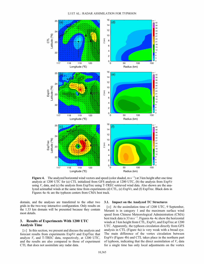
[22] At the assimilation time of 1200 UTC, 9 September,Meranti is in category 1 and the maximum surface windspeed from Chinese Meteorological Administration (CMA)best track data is 33m s�1. Figures 4a–4c show the horizontalwinds at 3 km height from CTL, ExpVr, and ExpTrec at 1200UTC. Apparently, the typhoon circulation directly from GFSanalysis in CTL (Figure 4a) is very weak with a broad eye.The main difference of the vortex circulation betweenExpVr (Figure 4b) and CTL takes place in the northern partof typhoon, indicating that the direct assimilation of Vr datafor a single time has only local adjustments on the vortex
Radius (km)
Z (
km)
(d)
0 50 100 150
Radius (km)0 50 100 150
Radius (km)0 50 100 150
0
2
4
6
8
10
12
14
16
Z (
km)
0
2
4
6
8
10
12
14
16
Z (
km)
0
2
4
6
8
10
12
14
16
0
3
6
9
12
15
18
21
24
27
30
33
36
39
42
(f)
0
3
6
9
12
15
18
21
24
27
30
33
36
39
42
(e)
0
3
6
9
12
15
18
21
24
27
30
33
36
39
42
CT
LE
xpV
rE
xpT
rec
(a)
Latit
ude
(o N)
Latit
ude
(o N)
RCCG
117 118 119 120
22
23
24
25
22
23
24
25
Latit
ude
(o N)
22
23
24
25
(b)
RCCG
(c)
RCCG
Longitude (oE)
117 118 119 120
Longitude (oE)
117 118 119 120
Longitude (oE)
Figure 4. The analyzed horizontal wind vectors and speed (color shaded, m s�1) at 3 km height after one timeanalysis at 1200 UTC for (a) CTL initialized from GFS analysis at 1200 UTC, (b) the analysis from ExpVrusing Vr data, and (c) the analysis from ExpTrec using T-TREC-retrieved wind data. Also shown are the ana-lyzed azimuthal winds at the same time from experiments (d) CTL, (e) ExpVr, and (f) ExpTrec. Black dots inFigures 4a–4c are the typhoon centers from CMA best track.
10,365
LI ET AL.: RADAR ASSIMILATION FOR TYPHOON

structure. This can be largely attributed to the limited coverageof Vr data at this time (see Figure 1a). The maximum wind inthe inner-core region in ExpVr is enhanced to 27m s�1 inthe northeastern quadrant versus less than 10m s�1 in CTL.Compared with ExpVr, ExpTrec (Figure 4c) produces a muchtighter and stronger circulation in the inner-core region. Thehighest wind speed is also located in the northeastern quadrantof the vortex, with a maximum wind speed of 30m s�1 at thislevel. To confirm the better quality of the analyzed circulationin ExpTrec, we projected the analyzed winds onto the radialdirections of Taiwan Chi-Gu (RCCG) radar (the location ofRCCG is shown in Figures 4a–4c) to obtain analyzed Vr dataand compared the data against RCCG Vr observations. Thecalculated RMSDs for CTL, ExpVr, and ExpTrec are 13.9,6.1, and 3.8m s�1, respectively, with that of ExpTrec beingclearly the smallest. It is worth pointing that given the maxi-mum surface winds from CMA at this time are ~33m s�1,although ExpTrec obviously improved over the other analy-ses, it is likely weaker than the true maximum winds at 3 kmheight level. To examine the vertical structure of the ana-lyzed typhoon, the corresponding azimuthal mean tangentialwinds are also plotted in Figures 4d–4f. The vortex circula-tions in CTL (Figure 4d) and ExpVr (Figure 4e) are muchweaker than that in ExpTrec (Figure 4f), which shows awell-defined TC circulation structure with strong winds(>20m s�1) extending to about 8 km height while those inCTL and ExpVr are much shallower. Note that althoughthe maximum wind speed at 3 km height in ExpVr reaches
27m s�1, the maximum mean tangential wind located at thislevel is only 16m s�1 (Figure 4e) owing to the asymmetricstructure of vortex circulation (Figure 4b). It is clear thatthe T-TREC-retrieved winds produce much more realisticwind structures of typhoon Meranti, especially in the inner-core region, at this time when Meranti was of Category 1.
3.2. Impact on the Track and Intensity Prediction
[23] The verifications of track and intensity forecasts forCTL, ExpVr, and ExpTrec are discussed in this subsection.Figure 5 shows the 18 h predicted typhoon track, track error,minimum sea-level pressure (MSLP), and maximum surface-wind speed (MSW), verified against the best track data fromCMA. During the period of landfall, Meranti moves north-ward with slight northwestward turn first, and then turnsslightly northeastward about 3 h after landfall. In both CTLand ExpVr, the predicted typhoon tracks turn unexpectednorthwestward in the first 3 h and then bias eastward withthe 18 h mean errors being 50 km and 72 km, respectively.The predicted landfall times are all delayed with eastwardbias of landfall locations. ExpVr actually moves slower andhas a larger track error than CTL, presumably due to thestrong asymmetric structures introduced into the vortex innerregion by the Vr DA (Figure 4b). In comparison, ExpTrecproduces a closed inner-core vortex circulation that is moreaxisymmetric (Figure 4c). With the improved IC, the pre-dicted typhoon in ExpTrec shows a mostly northward trackcloser to the best track, although slower than observed before
116 118 120 12222
24
26
28
XMRD
(a) Track
0 3 6 9 12 15 180
30
60
90
120
150
Tra
ck E
rro
r (k
m)
(b) Track Error50km for CTL
72km for ExpVr
32km for ExpTrec
Min
imu
m S
LP
(h
Pa)
(c) Minimum SLP
0 3 6 9 12 15 18950
960
970
980
990
1000
1010
1020
BESTCTLExpVrExpTrec
0 3 6 9 12 15 1810
15
20
25
30
35
40
45(d) Maximum surface wind
Max
imu
m s
urf
ace
win
d (
ms−1
)
Figure 5. The 18 h predicted (a) tracks, (b) track errors, (c) MSLP (hPa), and (d) MSW (m s�1), fortyphoon Meranti (2010), from 1200 UTC, 9 September to 0600 UTC, 10 September 2010. The numbersin Figure 5b represent the mean track errors over the 18 h period. Best track data are shown in black and3 h apart in Figure 5a.
10,366
LI ET AL.: RADAR ASSIMILATION FOR TYPHOON

landfall, resulting in an 18 h mean error of 32 km. Apparently,due to the limited spatial coverage and limited backgrounderror correlation scale, the radar data assimilation does notspread the impact very far from the data coverage regions,hence does not directly change the environment much. Still,the improvement to the typhoon structure by the T-TRECwind data is able to improve the track forecast (Figure 5).One possible mechanism by which the inner-core intensityand structure can affect TC track is the so-called “beta gyre”effect [Holland, 1983]. Through planetary vorticity advection,a “beta gyre” circulation form inducing cross vortex centerflow that affects TC track.[24] The MSLP and MSW of three experiments are plotted
along with the best track data in Figures 5c and 5d. Clearly,CTL under-predicts the intensity in terms of both MSLP andMSW,mainly owing to the weak vortex in the IC. ExpVr is lit-tle different, with the 18 h mean MSLP (MSW) improvement
over CTL [calculated as η ¼ 1�∑18
t¼1ExpVr tð Þ � BEST tð Þj j
∑18
t¼1CTL tð Þ � BEST tð Þj j
,
where BEST is for the best track data] of only 21.7%(18.1%). It indicates that assimilating Vr data only once atthe given time in this case cannot improve the intensity
forecasting much; local adjustments to the wind fields(Figure 4b) bring limited impact to the forecast. ExpTrecshows a notable improvement in intensity forecast especiallyin terms ofMSW. The 18 hmeanMSLP (MSW) improvement
over CTL [calculated as η ¼ 1�∑18
t¼1ExpTrec tð Þ � BEST tð Þj j
∑18
t¼1CTL tð Þ � BEST tð Þj j
]
is 43.0% (59.6%). It is noted that the analyzed MSLP andMSW in ExpTrec are nearly the same as those in CTL. Forthe MSLP, the limited increment is attributed to the weak mul-tivariate covariance in background error covariance matrix ofWRF 3DVAR between pressure and wind fields. For theMSW, although the winds at the higher levels are significantlyenhanced (Figure 4f), the surface wind increment is deter-mined by the vertical spatial covariance and the surface windspeed are not sufficiently influenced by radar measurements(see also Figure 4f), which at the location of maximum windspeed (Figure 4c) is about 3 km above sea surface. Despitethese obvious limitations with the WRF 3DVAR analysis,MSLP drops from 1001 hPa to 992 hPa during the first hourof forecast while MSW increases from 18ms�1 to 27m s�1
in 3 h, clearly in response to the strong analyzed typhooncirculations at the lower-middle and upper levels. After the
0
0
0
Radius (km)
Z (
km)
(a)
0 50 100 1500
2
4
6
8
10
12
14
16
0
0
0
0
1
1
11
2
Radius (km)
Z (
km)
(b)
0 50 100 1500
2
4
6
8
10
12
14
16
0
3
6
9
12
15
18
21
24
27
30
33
36
39
42
0
0
0
0
1
1
2
3
3
Radius (km)
Z (
km)
(c)
0 50 100 1500
2
4
6
8
10
12
14
16
Radius (km)
Z (
km)
(d)
0 50 100 1500
2
4
6
8
10
12
14
16
0
3
6
9
12
15
18
21
24
27
30
33
36
39
42
CTL ExpVr
ExpTrec
Figure 6. Azimuthal mean tangential winds (color shaded, m s�1) and temperature deviation (solid isolines)of the 6 h forecast valid at 1800 UTC for experiments (a) CTL, (b) ExpVr, and (c) ExpTrec, as compared withthe (d) GBVTD-derived azimuthal mean tangential wind.
10,367
LI ET AL.: RADAR ASSIMILATION FOR TYPHOON

adjustment period of about 6 h, the predicted MSW agreeswith the best track data very well through the rest of forecast-ing hours (Figure 5d). In comparison, the predicted MSLP atthe time of the lowest best track MSLP of about 970 hPa at1800 UTC (6 h) only reached 988 hPa. The high MSLP fore-cast bias can be partly attributed to the mutual adjustmentbetween pressure and analyzed wind fields after a single-timeanalysis. The ineffectiveness of wind data fully deepens a TCvortex in terms of MSLP has been found in earlier studies, andthe assimilation of additional reflectivity data tends to helpwithin the ARPS system using the cloud analysis procedure[e.g., Zhao and Xue, 2009].[25] It should also be pointed out that the best track MSLP
estimation has large uncertainty. In this case, the lowestMSLP in the Japanese Meteorological Administration besttrack data is actually only 985 hPa. To get some idea on theconsistency between the best track MSLP and MSW,GBVTD wind retrieved which provide more accurate hori-zontal TC circulation with retrieval errors of only 2m s�1
[Lee et al., 1999; Harasti et al., 2004] is performed usingthe radar Vr data; based on gradient wind balance withretrieved axisymmetric circulation, the estimated MSLP isabout 980 hPa [Zhao et al., 2012]. This suggests that the low-est CMA MSLP may be overestimated.[26] To better represent the storm intensity, the azimuthal
mean tangential winds and temperature anomalies at 1800UTC are plotted in Figures 6a–6c. For further comparison,GBVTD-retrieved tangential winds are also displayed inFigure 6d. Compared to CTL and ExpVr, ExpTrec showsmuch stronger tangential winds that extend from the surfaceto the upper levels; the outwardly-sloping isotachs in theinner-core region conform to typical observed TC structures[e.g., Marks and Houze, 1987] or simulation studies [e.g.,Liu et al., 1997, 1999]. The predicted vortex in ExpTrechas a much smaller radius of maximum wind (RMW) of
about 35 km, and the maximummean wind speed of 31m s�1
found in the boundary layer is comparable to the 35m s�1
GBVTD retrieval (Figure 6d). Consistent with the strongervortex circulation, the maximum temperature anomaly of3.5K (Figure 6c) is much larger than those of 1K in CTL(Figure 6a) and 2.5K in ExpVr (Figure 6b). These resultsfurther confirm that ExpTrec predicts a typhoon whose windstructures are more consistent with GBVTD retrieval circula-tion, while those in CTL and ExpVr do not possess the struc-tures typical of a category 1 typhoon at this time.[27] To further examine the time trend of intensity predic-
tions of three experiments, we plot in Figure 7 the time-radiusHovmöller diagrams of azimuthal-averaged tangential windspeeds at 1 km height. Among the three experiments, onlyExpTrec exhibits the correct intensity trend (cf., Figure 5d).In CTL (Figure 7a), the typhoon remains weak throughoutthe forecast. Initially, the storms are weak, with the peaktangential wind reaching only 12m s�1 and broadly locatedaround the radius of 120 km. During the entire forecast pe-riod, the maximum tangential winds do not change muchand the RMW remains at close to 120 km radius until after7 h or so. Even after that, the stronger winds remain verybroad (Figure 7a). In ExpVr (Figure 7b), with the help ofVr data, the peak tangential wind reaches 16m s�1 and theRMW of about 60 km is much smaller than that in CTL atthe initial time. The maximum tangential wind remains thislevel until about 8 h (the landfalling time), however after that,the RMW shrinks with the tangential wind speed increased(Figure 7b). It shows the unreasonable intensity trend inwhich the vortex circulation is intensified after landfall. Asthe predicted typhoon takes an eastern track closer to thecoast with almost half of the vortex remaining over oceanin ExpVr (Figure 5c), the intensity is overpredicted after2000 UTC because of slower decay of the vortex. In compar-ison, the peak tangential wind speed is about 24m s�1 at
Distance from vortex center (km)
Hou
rs a
fter
1200
UT
C 0
9 S
epte
mbe
r
(a)
0 50 100 1500
2
4
6
8
10
12
14
16
18
Distance from vortex center (km)
Hou
rs a
fter
1200
UT
C 0
9 S
epte
mbe
r
(b)
0 50 100 1500
2
4
6
8
10
12
14
16
18
Distance from vortex center (km)
Hou
rs a
fter
1200
UT
C 0
9 S
epte
mbe
r
(c)
0 50 100 1500
2
4
6
8
10
12
14
16
18
0
3
6
9
12
15
18
21
24
27
30
33
36
39
42
CTL ExpVr ExpTrec
Figure 7. Time-radius Hovmöller diagrams of azimuthal-averaged tangential wind (m s�1) at 1 kmheight from three experiments: (a) CTL, (b) ExpVr, and (c) ExpTrec. The thick line denotes the RMWat the same height.
10,368
LI ET AL.: RADAR ASSIMILATION FOR TYPHOON

55 km radius at the IC time in ExpTrec (Figure 7c). TheRMW shrinks to about 40 km between 6 to 8 h with the max-imum wind increases to 32m s�1 before landfall. After thelandfall at 2000 UTC, 9 September (8 h from the IC time),the RMW increases gradually and the wind speed decreasesbelow 18ms�1 at the end of the forecast. This “shrinking-expansion” process represents a correct trend of intensitychange before and after landfall, that is consistent with thebest track data shown in Figure 5.[28] To estimate the thermal structure during the whole
forecasting period, the time-height evolution of mean tem-perature anomalies (defined as the mean value of temperatureanomalies within the radius of 150 km centered the typhoon’ssurface minimum pressure for simulations) for simulatedstorms in CTL, ExpVr, and ExpTrec are plotted in Figure 8.
There is no obvious warm core structure at all heights inCTL (Figure 8a) suggesting the vortex structure is not wellestablished during the forecast. For ExpVr, during the first8 h before landfall, the warm anomalies are weak similar withCTL.While, after 9 h or so, the warm core appears at the levelof about 7 km height. The delayed formation of warm corestructure is consistent with the incorrect intensification afterlandfall in ExpVr (Figure 7b). In comparison, for ExpTrec,the maximum warm anomalies take place in the middle levelof about 8 km at the initial several hours of 1300 UTC to1400 UTC (Figure 8c) after the model adjustment. The layerof the warm core decreases to about 6 km after 9 h as thestorm declines due to the landfall. The peak anomaly inExpTrec is much higher than that in ExpVr, suggesting thelow predicted pressure (Figure 5c) in ExpTrec. The resultsagain indicate that the assimilation of T-TREC wind data atthe given time is much more effective than assimilating avail-able Vr data at the time.
3.3. Impact on the Typhoon Structure Prediction
[29] The composite radar reflectivity and 3 km height hor-izontal winds at 6, 12, and 18 h fromCTL, ExpVr, and ExpTrecare plotted in Figure 9, together with the corresponding ob-served reflectivity fields (first column).[30] At 1800 UTC, the 6 h forecast time, reflectivity echoes
are mainly found in the inner-core region or are associatedwith the outer rainbands more on the south side (Figure 9a).In CTL (Figure 9b), the vortex circulation is not well orga-nized in the inner-core region while most of the predictedprecipitation is in the northeastern quadrant unlike observed.Similar to CTL, ExpVr (Figure 9c) overpredicts the reflec-tivity in the northern quadrant and misses the main precipita-tion structure in the inner-core region. Besides, the predictedtyphoon location has more southward bias in ExpVr. Incomparison, precipitation structures in the inner-core regionare stronger in ExpTrec (Figure 9d), so is the rainbandextending south and southwestward on the south side. Theeyewall structure is also evident. Imperfect aspects of theprediction include overly strong predicted reflectivity andsoutherly displacement of the typhoon compared to observa-tions; the former may be linked to deficiencies in the Linmicrophysics scheme used while the latter is linked to thetoo slow movement of the typhoon before landfall, asmentioned earlier. Still, the improvements over CTL andExpVr are clear.[31] At 12 h, Meranti has made landfall and the precipita-
tion pattern becomes more asymmetric. The precipitation ismostly over land, and the observed typhoon eye is now filleddue to landfall. The weak storm in CTL (Figure 9f) movesnorth-northeastward within the background flow, deviatingfrom the observation, and typhoon structures are no longerclear. In ExpVr (Figure 9g), the disorganized vortex structurealso appears more south than the observed typhoon locationthe same as situation in the sixth forecast hour (Figure 9c).However, the storm in ExpTrec still shows a much betterorganized vortex with reflectivity mostly found on the westside of the typhoon center (Figure 9h), agreeing with observa-tions (Figure 9e). At 18 h, the precipitation becomes evenmore asymmetric and weaker. The reflectivity structure nearlyvanishes in CTL (Figure 9j). While ExpVr (Figure 9k) over-predict the reflectivity structure, indicating that the predictedtyphoon is stronger than the observed typhoon during this time.
Hours after 1200 UTC 09 September
Z (
km)
(c)
0 3 6 9 12 15 180
2
4
6
8
10
12
14
16
−1
0
1
2
3
CTL
ExpVr
ExpTrec
Hours after 1200 UTC 09 September
Z (
km)
(b)
0 3 6 9 12 15 180
2
4
6
8
10
12
14
16
−1
0
1
2
3
Z (
km)
(a)
0 3 6 9 12 15 180
2
4
6
8
10
12
14
16
−1
0
1
2
3
Hours after 1200 UTC 09 September
Figure 8. Time-height diagrams of mean temperatureanomalies from three experiments: (a) CTL, (b) ExpVr, and(c) ExpTrec. The average is computed within the radius of150 km centered at the typhoon’s surface minimum pressurefor simulations.
10,369
LI ET AL.: RADAR ASSIMILATION FOR TYPHOON
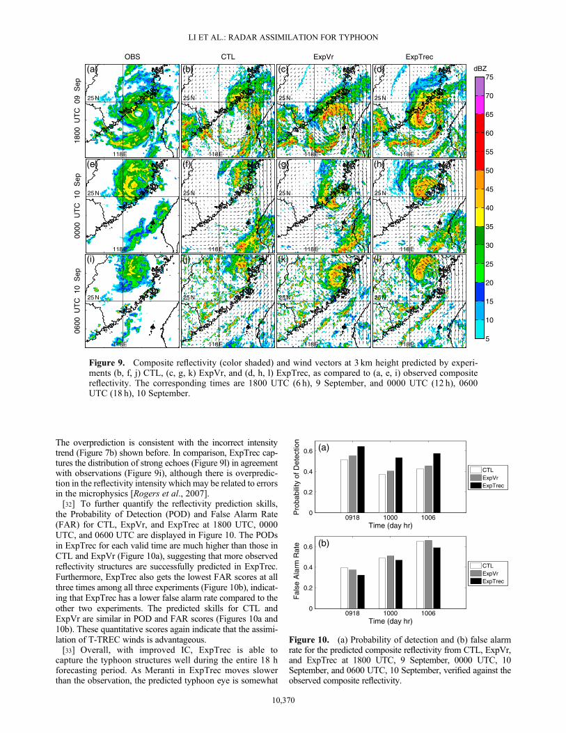
The overprediction is consistent with the incorrect intensitytrend (Figure 7b) shown before. In comparison, ExpTrec cap-tures the distribution of strong echoes (Figure 9l) in agreementwith observations (Figure 9i), although there is overpredic-tion in the reflectivity intensity which may be related to errorsin the microphysics [Rogers et al., 2007].[32] To further quantify the reflectivity prediction skills,
the Probability of Detection (POD) and False Alarm Rate(FAR) for CTL, ExpVr, and ExpTrec at 1800 UTC, 0000UTC, and 0600 UTC are displayed in Figure 10. The PODsin ExpTrec for each valid time are much higher than those inCTL and ExpVr (Figure 10a), suggesting that more observedreflectivity structures are successfully predicted in ExpTrec.Furthermore, ExpTrec also gets the lowest FAR scores at allthree times among all three experiments (Figure 10b), indicat-ing that ExpTrec has a lower false alarm rate compared to theother two experiments. The predicted skills for CTL andExpVr are similar in POD and FAR scores (Figures 10a and10b). These quantitative scores again indicate that the assimi-lation of T-TREC winds is advantageous.[33] Overall, with improved IC, ExpTrec is able to
capture the typhoon structures well during the entire 18 hforecasting period. As Meranti in ExpTrec moves slowerthan the observation, the predicted typhoon eye is somewhat
1800
UT
C 0
9 S
ep
OBS
118 E
25 N
(a)00
00 U
TC
10
Sep
118 E
25 N
(e)
0600
UT
C 1
0 S
ep
118 E
25 N
(i)
CTL
118 E
25 N
(b)
118 E
25 N
(f)
118 E
25 N
(j)
ExpVr
118 E
25 N
(c)
118 E
25 N
(g)
118 E
25 N
(k)
ExpTrec
118 E
25 N
(d)
118 E
25 N
(h)
118 E
25 N
(l)
dBZ
5
10
15
20
25
30
35
40
45
50
55
60
65
70
75
Figure 9. Composite reflectivity (color shaded) and wind vectors at 3 km height predicted by experi-ments (b, f, j) CTL, (c, g, k) ExpVr, and (d, h, l) ExpTrec, as compared to (a, e, i) observed compositereflectivity. The corresponding times are 1800 UTC (6 h), 9 September, and 0000 UTC (12 h), 0600UTC (18 h), 10 September.
0918 1000 10060
0.2
0.4
0.6
Time (day hr)
Pro
babi
lity
of D
etec
tion
(a)
CTLExpVrExpTrec
0918 1000 10060
0.2
0.4
0.6
Time (day hr)
Fal
se A
larm
Rat
e (b)
CTLExpVrExpTrec
Figure 10. (a) Probability of detection and (b) false alarmrate for the predicted composite reflectivity from CTL, ExpVr,and ExpTrec at 1800 UTC, 9 September, 0000 UTC, 10September, and 0600 UTC, 10 September, verified against theobserved composite reflectivity.
10,370
LI ET AL.: RADAR ASSIMILATION FOR TYPHOON

south of the observed center. Assimilating Vr data from asingle radar for only one time in this case fails to reproducethe structure of typhoon inner core correctly, and actuallythe track forecasting even worse. Impacts are expected tobe greater when more assimilation cycles and radars areused over a period of time [Xiao et al., 2005; Zhao andXue, 2009].
3.4. Impact on Precipitation Forecast
[34] Figure 11 compares the 6 h accumulated precipitationfields valid at 0000 and 0600UTC, 10 September, respectively,from CTL, ExpVr, and ExpTrec together with objective analy-ses of the automatic weather station rainfall measurements.During the landfall period, the observation (Figure 11a) shows aband of strong precipitation along the coast of Fujian Province.Neither CTL (Figure 11b) nor ExpVr (Figure 11c) predicts thispattern or intensity due to their eastward track bias and low in-tensity. On the contrary, ExpTrec (Figure 11d) captures reason-ably well the strong precipitation region near the coast. Theprecipitation distribution is more south than observation owingto its slower movement. After landfall, the main precipitationband moves north with the typhoon, producing an elongatedregion of high precipitation along 118.5°E (Figure 11e). CTL(Figure 11f) has a northeastward bias of precipitation distribu-tion with much smaller magnitude. While, ExpVr (Figure 11g)represents a similar pattern as the observation except for thehigh precipitation located much more south. The precipitationof ExpTrec (Figure 11h) compares with the observation muchbetter in both distribution and intensity.[35] To quantify the precipitation forecast skills, equitable
threat scores (ETS) and frequency bias scores of 12 h accumu-lated precipitation valid at 0600 UTC, 10 September againstthe rainfall observations are calculated and plotted for thresh-olds ranging from 0mm to 150mm in Figure 12. It is obviousthat CTL has little skill in heavy rain prediction for thresholdsabove 50mm (Figure 12a). ExpVr has some improvement in
the skill of heavy rain while the maximum ETS score is only0.22. Both of them also under-forecast the precipitationamounts for both weak and heavy rainfall (Figure 12b). Forall thresholds, ExpTrec has much higher ETS scores thanother two experiments, with the maximum score being about
18:0
0Z 0
9 S
ep 2
010
− 0
0:00
Z 1
0 S
ep 2
010
OBS
(a)119 E
26 N
00:0
0Z 1
0 S
ep 2
010
− 0
6:00
Z 1
0 S
ep 2
010
(e)119 E
26 N
CTL
(b)119 E
26 N
(f)119 E
26 N
ExpVr
(c)119 E
26 N
(g)119 E
26 N
ExpTrec
(d)119 E
26 N
(h)119 E
26 N
mm
1
10
20
30
50
75
100
150
200
250
Figure 11. The 6 h accumulated precipitation (mm) valid at (a–d) 0000 UTC and (e–h) 0600 UTC on 10September 2010 from automatic weather station hourly observations (Figures 11a and 11e), (Figures 11band 11f) CTL, (Figures 11c and 11g) ExpVr, and (Figures 11d and 11h) ExpTrec.
0 50 100 1500
0.1
0.2
0.3
0.4
0.5
0.6
0.7
Precipitation amount (mm)
Equ
itabl
e T
hrea
t Sco
re
(a) CTLExpVrExpTrec
0 50 100 1500
0.5
1
1.5
2
Precipitation amount (mm)
Bia
s S
core
(b) CTLExpVrExpTrec
Figure 12. (a) Equitable threat scores and (b) bias scores ofthe 12 h accumulated precipitation forecast valid at 0600UTC, 10 September from CTL, ExpVr, and ExpTrec verifiedagainst the automatic weather station observations.
10,371
LI ET AL.: RADAR ASSIMILATION FOR TYPHOON
0.58 at about 20mm threshold (Figure 12a). ExpTrec alsoproduces excellent frequency biases that are very close to 1for more thresholds (Figure 12b). The improvements in pre-cipitation forecast are attributed to the improved intensityand structure forecasting.
4. Results of Experiments With LaterAnalysis Times
[36] In this section, the results of the experiments withanalysis times at 1400, 1600, and 1800 UTC are presented.
Lat
itu
de
(oN
)
XMRD
(a)
118 12022
24
1400 UTC
1600 UTC
1800 UTC
XMRD
(c)
118 12022
24
XMRD
(e)
118 12022
24
XMRD
(b)
118 12022
24
−39
−33
−27
−21
−15
−9
−3
3
9
15
21
27
33
39
XMRD
(d)
118 12022
24
−39
−33
−27
−21
−15
−9
−3
3
9
15
21
27
33
39
XMRD
(f)
118 12022
24
−39
−33
−27
−21
−15
−9
−3
3
9
15
21
27
33
39
Figure 13. (a, c, e) Observed radial velocity and (b, d, f) the radial velocity calculated from T-TRECwinds at3 km height at 1400UTC (Figures 13a and 13b), 1600UTC (Figures 13c and 13d), and 1800UTC (Figures 13eand 13f), 9 September 2010. “+” denotes the center of vortex.
10,372
LI ET AL.: RADAR ASSIMILATION FOR TYPHOON

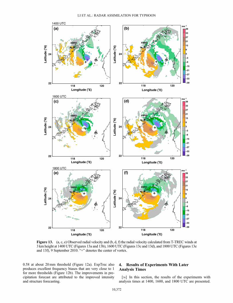
For brevity, we focus on the predicted track and intensityin these experiments.[37] Figure 13 displays the observed and T-TREC-retrieved
Vr at 3 km height at 1400, 1600, and 1800 UTC, 9 September.The T-TREC-retrieved Vr (Figures 13b, 13d, 13f) shows quitesimilar patterns to observed Vr (Figures 13a, 13c, 13e) at eachtime within the observed Vr coverage. At 1400 UTC, the ob-served Vr shows an incomplete velocity dipole pattern associ-ated with typhoon inner core, while the T-TREC-retrieved Vryields a more complete velocity dipole pattern. As the typhoongets closer to the radar at 1600 and 1800 UTC, the observed Vr
fully covers the typhoon inner-core region (Figures 13c and13e). However, the T-TREC-retrieved winds still have theadvantage of being able to cover the complete TC circulation(Figures 13d and 13f).[38] Figure 14 shows the track and intensity forecasts of
all experiments (Table 1). For all experiments that assimilateT-TREC winds, the mean predicted track, MSLP and MSWerrors are similar in ExpTrec, ExpTrec14, and ExpTrec16.The mean MSLP (MSW) errors are 12.1 hPa (3.8m s�1),12.4 hPa (3.7m s�1), and 12.3 hPa (3.1m s�1), respectively.However, since the assimilation time in ExpTrec18 is closeto the landfall time of ~2000 UTC, and without the benefitof a longer model spin up, the predicted MSLP and MSW
(Figures 14c and 14d) in ExpTrec18 are much weaker thanin earlier experiments before landfall and decline quicklyfurther after landfall.[39] Among all the experiments that assimilate Vr data,
the later assimilation times in ExpVr14 and ExpVr16 resultin better track (Figures 14a and 14b) and intensity forecasts(Figures 14c and 14d) than in ExpVr. The mean track errorsin ExpVr14 and ExpVr16 are 51 km and 49 km, respec-tively, smaller than the 72 km of ExpVr. The mean pre-dicted MSLP (MSW) errors in ExpVr14 and ExpVr16 are15.2 hPa (6.4 m s�1) and 13.7 hPa (3.6 m s�1), respectively,better than the 16.6 hPa (7.7 m s�1) of ExpVr. The improvedtrack and intensity forecasts can be attributed to the increas-ingly larger Vr coverage as Meranti moves closer to theradar (Figures 13a and 13c). It is worth pointing out that,as TC approaches the coastline, the performance of Vr
assimilation in ExpVr16 and ExpVr18 becomes close tothe T-TREC assimilation in ExpTrec16 and ExpTrec18.The mean MSLP (MSW) errors are 13.7 hPa (3.6m s�1)and 13.5 hPa (5.5m s�1) in ExpVr16 and ExpVr18, incomparison to the 12.3 hPa (3.1m s�1) and 13 hPa (5.3m s�1)in ExpTrec16 and ExpTrec18. Yet, the assimilation ofT-TREC data at 1600 UTC and 1800 UTC still maintains aslight advantage.
117 118 119 120 121
23
24
25
26
27
XMRD
(a) Track
0 3 6 9 12 15 180
30
60
90
120
150
180
Tra
ck E
rro
r (k
m)
(b) Track ErrorExpTrec (32 km)ExpTrec14 (28 km)ExpTrec16 (32 km)ExpTrec18 (39 km)ExpVr (72 km)ExpVr14 (51 km)ExpVr16 (49 km)ExpVr18 (47 km)
Forecast Hour
Min
imu
m S
LP
(h
Pa)
(c) Minimum SLP
0 3 6 9 12 15 18
950
960
970
980
990
1000
1010
1020
ExpTrec (12.1 hPa)ExpTrec14 (12.4 hPa)ExpTrec16 (12.3 hPa)ExpTrec18 (13 hPa)ExpVr (16.6 hPa)ExpVr14 (15.2 hPa)ExpVr16 (13.7 hPa)ExpVr18 (13.5 hPa)
0 3 6 9 12 15 18
10
15
20
25
30
35
40
Forecast Hour
Max
imu
m s
urf
ace
win
d (
ms−1
)
(d) Maximum surface wind
ExpTrec (3.8 m/s)ExpTrec14 (3.7 m/s)ExpTrec16 (3.1 m/s)ExpTrec18 (5.3 m/s)ExpVr (7.7 m/s)ExpVr14 (6.4 m/s)ExpVr16 (3.6 m/s)ExpVr18 (5.5 m/s)
Figure 14. The predicted (a) tracks, (b) track errors, (c) MSLP (hPa), and (d) MSW (m s�1) for experi-ments ExpVr, ExpVr14, ExpVr16, ExpVr18, ExpTrec, ExpTrec14, ExpTrec16, and ExpTrec18. The num-bers in Figures 14b–14d represent the mean track errors, mean MSLP errors, and mean MSW errors,respectively. The vertical dashed line in Figures 14c and 14d represents the landfalling time for typhoonMeranti (2010).
10,373
LI ET AL.: RADAR ASSIMILATION FOR TYPHOON
[40] Overall, except for the assimilation at 1800 UTCwhichis very close to landfall, the assimilation of T-TREC data 8 to4 h before landfall shows consistently positive impacts on theforecast of typhoon Meranti. For Vr data, later analysis timesresult in larger positive impacts but the forecasts are generallypoorer than the corresponding T-TREC assimilation experi-ments. The difference between Vr and T-TREC assimilationsis largest at the earliest time when T-TREC retrieval can besuccessfully performed. The much improved forecast at a lon-ger lead time with the T-TREC DA is especially valuable forreal time decision making.
5. Summary and Conclusions
[41] An extended TREC technique, called T-TREC, was de-veloped recently for retrieving wind circulations in TCs fromsingle Doppler radar reflectivity (Z) and radial velocity (Vr)data from two consecutive times. This study explores, for thefirst time, the assimilation of T-TREC-retrieved wind data forthe analysis and prediction of a TC. TheWRF 3DVAR is usedfor the data assimilation, while the landfalling typhoonMeranti(2010) near southeastern coast of China is chosen as the testcase. The main conclusions are summarized as follows.[42] A single-time analysis at 1200 UTC, 9 September is
first performed when the center of Meranti was in the fullcoverage of reflectivity data (which has a 460 km range fromradar) of the Xiamen radar in Fujian Province, but the radialvelocity only provides partial coverage of typhoon circula-tion and misses much of the inner-core structure. Resultsshow that the assimilation of T-TREC-retrieved wind dataimproves the inner-core circulation of typhoon significantly,while the assimilation of Vr data only makes differenceswithin the Doppler coverage at the given analysis time. Theasymmetric vortex structure brought by the single-time as-similation of Vr data fails to reproduce the reasonable pre-dicted typhoon throughout the entire forecasting period.The track forecast is actually even worse and the intensityforecast has incorrect trend especially after landfall. On thecontrary, the effectiveness of the T-TREC-retrieved wind datais associated with the large spatial coverage of reflectivity dataused for the retrieval and the complete typhoon inner-core cir-culation that can be effectively represented by the T-TRECretrieval. The resulting improved typhoon intensity and struc-ture leads to better track, intensity, and structure predictionsthroughout the 18 h of forecast. The predicted intensity showsa correct trend also. Benefiting from the improved track andstructure forecasting, the heavy rain at coastal Fujian provinceof China is reproduced well in terms of both intensity and dis-tribution. Excellent precipitation ETS scores and frequencybias are obtained. The results indicate the efficacy of assimilat-ing T-TREC-retrieved winds for TC initiations when such datacan be retrieved from reflectivity data with much farther off-shore reach than radial velocity data with typical operationalweather radars. Additional experiments with later assimilationtimes and closer radar distances show that the assimilationof T-TREC winds consistently outperforms Vr assimilation,although the difference becomes smaller as the Vr coverageimproves with time.[43] Because the T-TREC retrieval procedure is computa-
tionally rather efficient, the T-TREC-retrieved winds can beeasily used for operational forecasting. The use of T-TRECwinds can also help extend the utilization of radar data by
several hours for a landfalling TC, because of the typicalfarther reach of the reflectivity data used for the retrieval,thereby benefiting advanced typhoon warning. Althoughconclusions drawn within this paper are based on a singlelandfalling typhoon, we have applied the same approach totyphoon Chanthu (2010) and all the results are consistentwith the findings here. In the future, we will test the proce-dure with more cases. At the same time, we are also examin-ing the impacts of Vr versus T-TREC winds by assimilatingthe data using the more advanced ensemble Kalman filtermethod for another typhoon (M. Wang et al., Assimilationof T-TREC-retrieved winds from single-Doppler radar withan EnKF for the forecast of Typhoon Jangmi (2008), submit-ted to Monthly Weather Review, 2013); similarly, encourag-ing results are obtained.[44] A few other issues will require further research. When
the typhoon gets closer to the coast, it may be covered byseveral coast radars. Direct assimilation of Vr data from mul-tiple Doppler radars may become more effective, while therelative advantage of using T-TREC-retrieved winds may de-crease. It is also possible to assimilate both Vr and T-TRECretrievals at the same time, and the data can be assimilatedthrough continuous cycles. It would also be interesting tocompare the assimilation of T-TREC winds and the assimila-tion of GBVTD retrieval winds [Zhao et al., 2011] when bothare available. The relative impacts of assimilating each typeof data alone or in combination through varied assimilationprocedure are worthy topics for future research.
[45] Acknowledgments. This work was primarily supported by theSocial Common Wealth Research Program (GYHY201006007 andGYHY201206005), the National Fundamental Research 973 Program ofChina (2009CB421502 and 2013CB430100), and the Chinese NaturalScience Foundation (grants 41105035, 40975011, and 40921160381).We are grateful to the High Performance Computing Center of NanjingUniversity for doing the numerical calculations in this paper on its IBMBlade cluster system. We also thank the three anonymous reviewers whoprovided valuable suggestions for improving our manuscript.
ReferencesBarker, D. M., W. Huang, Y.-R. Guo, A. J. Bourgeois, and Q. N. Xiao(2004), A three-dimensional variational data assimilation system forMM5: Implementation and initial results, Mon. Weather Rev., 132,897–914.
Brown, R. A., and V. T.Wood (1983), Improved severe stormwarning usingDoppler radar, Natl. Weather Digest, 8(3), 19–27.
Chen, F., and J. Dudhia (2001), Coupling an advanced land-surface/hydrol-ogy model with the Penn State/NCAR MM5 modeling system. Part I:Model description and implementation, Mon. Weather Rev., 129,569–585.
Chen, S.-H., and W.-Y. Sun (2002), A one-dimensional time dependentcloud model, J. Meteorol. Soc. Jpn., 80, 99–118.
Chou, K.-H., C.-C. Wu, P.-H. Lin, S. D. Aberson, M. Weissmann,F. Harnisch, and T. Nakazawa (2011), The impact of dropwindsondeobservations on typhoon track forecasts in DOTSTAR and T-PARC,Mon. Weather Rev., 139, 1728–1743.
Dong, J., and M. Xue (2012), Assimilation of radial velocity and reflectivitydata from coastal WSR-88D radars using ensemble Kalman filter for theanalysis and forecast of landfalling hurricane Ike (2008), Q. J. Roy.Meteorol. Soc., doi:10.1002/qj.1970.
Du, N., M. Xue, K. Zhao, and J. Min (2012), Impact of assimilating airborneDoppler radar velocity data using the ARPS 3DVAR on the analysisand prediction of hurricane Ike (2008), J. Geophys. Res., 117, D18113,doi:10.1029/2012JD017687.
Dudhia, J. (1989), Numerical study of convection observed during the wintermonsoon experiment using a mesoscale two-dimensional model, J. Atmos.Sci., 46, 3077–3107.
Hamill, T. M., J. S. Whitaker, M. Fiorino, and S. G. Benjamin (2011), Globalensemble predictions of 2009’s tropical cyclones initialized with an en-semble Kalman filter, Mon. Weather Rev., 139, 668–688.
10,374
LI ET AL.: RADAR ASSIMILATION FOR TYPHOON

Harasti, P. R., C. J. McAdie, P. P. Dodge, W. C. Lee, J. Tuttle, S. T. Murillo,and F. D. Marks (2004), Real-time implementation of single-Dopplerradar analysis methods for tropical cyclones: Algorithm improvementsand use with WSR-88D display data, Weather Forecast., 19, 219–239.
Holland, G. J. (1983), Tropical cyclone motion: Environmental interactionplus a beta effect, J. Atmos. Sci., 40, 328–342.
Houze, R. A., Jr., S. S. Chen, B. F. Smull, W. C. Lee, and M. M. Bell (2007),Hurricane intensity and eyewall replacement, Science, 315, 1235–1239.
Kain, J. S. (2004), The Kain-Fritsch convective parameterization: An update,J. Appl. Meteorol. Climatol., 43, 170–181.
Kain, J. S., and J. M. Fritsch (1990), A one-dimensional entraining/detraining plumemodel and its application in convective parameterization,J. Atmos. Sci., 47, 2784–2802.
Lee, W. C., B. J. D. Jou, P. L. Chang, and S. M. Deng (1999), Tropicalcyclone kinematic structure retrieved from single-Doppler radar observa-tions. Part I: Interpretation of Doppler velocity patterns and the GBVTDtechnique, Mon. Weather Rev., 127, 2419–2439.
Li, Y., X. Wang, and M. Xue (2012), Assimilation of radar radial velocitydata with the WRF ensemble-3DVAR hybrid system for the predictionof hurricane Ike (2008), Mon. Weather Rev., 140, 3507–3524.
Lin, Y.-L., R. D. Farley, and H. D. Orville (1983), Bulk parameterizationof the snow field in a cloud model, J. Appl. Meteorol. Climatol., 22,1065–1092.
Liu, Y., D.-L. Zhang, andM. K. Yau (1997), Amultiscale numerical study ofHurricane Andrew (1992). Part I: An explicit simulation, Mon. WeatherRev., 125, 3073–3093.
Liu, Y., D.-L. Zhang, andM. K. Yau (1999), Amultiscale numerical study ofhurricane Andrew (1992). Part II: Kinematics and inner-core structures,Mon. Weather Rev., 127, 2597–2616.
Marks, F. D., and R. A. Houze Jr. (1987), Inner core structure of HurricaneAlicia from airborne Doppler-radar observations, J. Atmos. Sci., 44,1296–1317.
Mlawer, E. J., S. J. Taubman, P. D. Brown, andM. J. Iacono (1997), Radiativetransfer for inhomogeneous atmospheres: RRTM, a validated correlated-kmodel for the longwave, J. Geophys. Res., 102, 16,663–16,682.
Monin, A. S., and A. M. Obukhov (1954), Basic laws of turbulent mixing inthe ground layer of the atmosphere, in Russian, Tr. Geofiz. Inst. Akad.Nauk SSR, 151, 163–187.
Noh, Y., W. G. Cheon, S.-Y. Hong, and S. Raasch (2003), Improvement ofthe K-profile model for the planetary boundary layer based on large eddysimulation data, Boundary Layer Meteorol., 107, 401–427.
Oye, R., C. Mueller, and C. Smith (1995), Software for radar data translation,visualization, editing, and interpolation, in 27th Conference on RadarMeteorology, pp. 359–361, Am. Meteorol. Soc, Boston, Mass.
Parrish, D. F., and J. C. Derber (1992), The national meteorological center’sspectral statistical interpolation analysis system, Mon. Wea. Rev., 120,1747–1763.
Pu, Z., X. Li, C. Velden, S. Aberson, andW. T. Liu (2008), Impact of aircraftdropsonde and satellite wind data on the numerical simulation of twolandfalling tropical storms during the Tropical Cloud Systems andProcesses Experiment, Weather Forecast., 23, 62–79.
Pu, Z., X. Li, and J. Sun (2009), Impact of airborne Doppler radar data assim-ilation on the numerical simulation of intensity changes of HurricaneDennis near a landfall, J. Atmos. Sci., 66, 3351–3365.
Rappaport, E. N., et al. (2009), Advances and challenges at the NationalHurricane Center, Weather Forecast., 24, 395–419.
Rogers, R. F., M. L. Black, S. S. Chen, and R. A. Black (2007), An evalua-tion of microphysics fields from mesoscale model simulations of tropicalcyclones. Part I: Comparisons with observations, J. Atmos. Sci., 64,1811–1834.
Roux, F., and F. D. Marks (1996), Extended velocity track display (EVTD):An improved processing method for Doppler radar observations. Part I:Kinematics, Mon. Weather Rev., 123, 2611–2639.
Skamarock, W. C., J. B. Klemp, J. Dudhia, D. O. Gill, D. M. Barker,M. G. Duda, X.-Y. Huang, W. Wang, and J. G. Powers (2008), Descriptionof the advanced research WRF version 4, Rep. NCAR/TN-475++STR, Natl.Cent. for Atmos. Res., Boulder, Colo.
Tuttle, J., and R. Gall (1999), A single-radar technique for estimating thewinds in tropical cyclones, Bull. Am. Meteorol. Soc., 80, 653–668.
Wang,M. J., K. Zhao, and D.Wu (2011), The T-TREC technique for retriev-ing the winds of landfalling typhoons in China, Acta Meteorol. Sin, 25,91–103.
Weng, Y., and F. Zhang (2012), Assimilating airborne Doppler radar obser-vations with an ensemble Kalman filter for convection-permitting hurri-cane initialization and prediction: Katrina (2005), Mon. Weather Rev.,140, 841–859.
Xiao, Q., and J. Sun (2007), Multiple-radar data assimilation and short-rangequantitative precipitation forecasting of a squall line observed duringIHOP_2002, Mon. Weather Rev., 135, 3381–3404.
Xiao, Q., Y.-H. Kuo, J. Sun, W.-C. Lee, E. Lim, Y.-R. Guo, andD. M. Barker (2005), Assimilation of Doppler radar observations with aregional 3DVAR system: Impact of Doppler velocities on forecasts of aheavy rainfall case, J. Appl. Meteorol. Climatol., 44, 768–788.
Xiao, Q., L. Chen, and X. Zhang (2009a), Evaluations of BDA scheme usingthe advanced research WRF (ARW) model, J. Appl. Meteorol. Climatol.,48, 680–689.
Xiao, Q., X. Zhang, C. A. Davis, J. Tuttle, G. J. Holland, and P. J. Fitzpatrick(2009b), Experiments of hurricane initialization with airborne Doppler ra-dar data for the advanced research hurricane WRF (AHW) model, Mon.Weather Rev., 137, 2758–2777.
Xue, M., D. H. Wang, J. D. Gao, K. Brewster, and K. K. Droegemeier(2003), The Advanced Regional Prediction System (ARPS), storm-scalenumerical weather prediction and data assimilation, Meteorol. Atmos.Phys., 82(1–4), 139–170.
Zhang, F., Y. Weng, J. A. Sippel, Z. Meng, and C. H. Bishop (2009), Cloud-resolving hurricane initialization and prediction through assimilation ofDoppler radar observations with an ensemble Kalman filter, Mon. WeatherRev., 137, 2105–2125.
Zhao, K., and M. Xue (2009), Assimilation of coastal Doppler radardata with the ARPS 3DVAR and cloud analysis for the prediction ofHurricane Ike (2008), Geophys. Res. Lett., 36, L12803, doi:10.1029/2009GL038658.
Zhao, K., M. Xue, and W.-C. Lee (2011), Assimilation of GBVTD-retrievedwinds from single-Doppler radar for short-term forecasting of super typhoonSaomai (0608) at landfall, Q. J. Roy. Meteorol. Soc., 138, 1055–1071.
Zhao, K., X. Li, M. Xue, B. J.-D. Jou, and W.-C. Lee (2012), Short-termforecasting through intermittent assimilation of data from Taiwan andmainland China coastal radars for Typhoon Meranti (2010) at landfall,J. Geophys. Res., 117, D06108, doi:10.1029/2011JD017109.
Zou, X., and Q. Xiao (2000), Studies on the initialization and simulation of amature hurricane using a variational bogus data assimilation scheme,J. Atmos. Sci., 57, 836–860.
10,375
LI ET AL.: RADAR ASSIMILATION FOR TYPHOON