Assessment under the Habitats Regulations Appropriate ... Summary 1.1 The Screening Assessment has...
24
Assessment under the Habitats Regulations Appropriate Assessment Main Modifications MM6 and MM16 Local Plan Sites Document Examination in Public December 2018
Transcript of Assessment under the Habitats Regulations Appropriate ... Summary 1.1 The Screening Assessment has...
Assessment under the Habitats Regulations
Appropriate Assessment
Main Modifications MM6 and MM16
Local Plan Sites Document Examination in Public
December 2018

Contents
Page 1. Executive Summary
1
2. Requirement for Appropriate Assessment
2
3. Appropriate Assessment Methodology
3
4. Mitigation Measures and In-Combination Effects
7
5. Conclusion 10 Appendices 1. Detailed Assessment of effects on Natura 2000 sites

1
1. Executive Summary 1.1 The Screening Assessment has identified that, with the exception of Main Modification
6 and Main Modification16 (hereafter MM6 and MM16), all other proposed Main
Modifications of the Local Plan Sites Document would have no Likely Significant Effects
on the conservation objectives of Natura 2000 sites. Likely Significant Effects are: “Any
effect that may reasonably be predicted as a consequence of a plan or project that may
affect the achievement of conservation objectives of the features for which the site was
designated, but excluding trivial or inconsequential effects (de minimis)”.
1.2 In relation to MM6 and MM16, it is the impact relating to the potential for mineral
working of sites in Malton and Norton. The impact on the integrity of Natura 2000 sites
could not be conclusively established at the Screening Assessment in relation to the
River Derwent SAC (and Lower Derwent Valley SAC/SPA/Ramsar Site). Mitigation
measures both embedded in established policy, or direct, site-specific mitigation would
be applied. Therefore under the Habitats Directive (and the 2018 Court Judgement) an
Appropriate Assessment is required.
1.3.1 This Appropriate Assessment has considered in more detail the scope and nature of
any potential for harm to the integrity of Natura 2000 sites. This has revealed that
effects may occur in relation to:
Effects on water quality in the River Derwent SAC and Lower Derwent SAC, SPA and Ramsar from increased run-off; and
Effects on species in the River Derwent SAC from any need (resulting from increased rates of run-off) to alter water level controls or provide additional flood defences; or changes to the hydrological regime as a result of ground workings as part of minerals extraction. With consequential impacts Qualifying Habitat Water courses of plain to montane levels with the Ranunculion fluitantis and Callitricho-Batrachion vegetation; Rivers with floating vegetation often dominated by water-crowfoot And Species : Petromyzon marinus; Sea lamprey Lampetra fluviatilis; River lamprey Cottus gobio; Bullhead Lutra lutra; Otter;
1.3 The key objective of the allocations is to deliver new housing or employment land, and
any minerals working is a by-product of that key land use change. Nevertheless, the
Appropriate Assessment process has afforded greater examination of the nature of the
individual sites and their development scenarios, and the application of both embedded
mitigation measures, with the implementation of Local Plan Strategy Policies, and site
specific measures within the wording the Local Plan Sites Document have been
identified which will ensure that any adverse effects are avoided.
1.4 In light of the findings of this assessment, and allowing for appropriate avoidance
measures to be implemented; Ryedale District Council is satisfied that the proposed
MM6 and MM16 will not harm the integrity, and in particular the conservation
objectives, of any Natura 2000 sites.

2
2. Requirement for an Appropriate Assessment 2.1 The Habitats Directive states that ‘any plan or project not directly connected with or
necessary to the management of the site but likely to have a significant effect thereon,
either individually or in combination with other plans, shall be subject to appropriate
assessment of its implications for the site in view of the site’s conservation objectives.
In light of the conclusions of that assessment of the implications for the site and subject
to the provisions of paragraph 4, the competent national authorities shall agree to the
plan or project only after having ascertained that it will not adversely affect the integrity
of the site concerned and, if appropriate, after having obtained the opinion of the
general public.’
2.2 The Screening Assessment report contains more information on the background to
Habitats Regulations Assessment, and process which needs to be undertaken.
2.3 This Appropriate Assessment therefore aims to ensure there will be no harm to the
integrity of Natura 2000 sites from the proposed Main Modifications (specifically MM6
and MM16) which are proposed in the Local Plan Sites Document Main Modifications
Consultation.
Screening Assessment (Main Modifications)
2.4 The Screening Assessment of Main Modifications has been undertaken in detail. It
concluded that for the vast majority of Main Modifications there would be no Likely
Significant Effects on the conservation objectives of the Natura 2000 sites.
2.5 However, the Screening Assessment could not rule out no likely significant effect from
MM6 (SD3 Housing Allocation -Land to the east of Beverley Road, Norton:
Development Principles) and MM16 (Policy SD12 New Employment Land Allocations
– Specifically the proposed Broad Location). This was in relation to the application of
mineral safeguarding considerations, and specifically concerning the River Derwent
SAC. The areas for investigated centred on implications for water flows as a result of
changes to the hydrological regime, or potential for contamination. It concluded that
whilst significant effects may not be likely, they are possible, and could not be ruled out
at that stage. The Screening Assessment took a precautionary approach, and therefore
concluded that it is necessary to undertake an Appropriate Assessment of those sites
and obtain further information about the nature of the impact, and whether avoidance
of harm was achievable in the first instance.
3
3. Appropriate Assessment Methodology
3.1 The following guidance has been taken into account in undertaking the Habitats
Regulations Assessment:
Conservation of Habitats and Species Regulations 2010 (as amended) Chapter 1 and Chapter 8
http://www.legislation.gov.uk/uksi/2010/490/contents/made
Assessment of Plans and Projects Significantly Affecting Natura 2000 Sites’ (European Commission, 2001)
http://ec.europa.eu/environment/nature/natura2000/management/docs/art6/natura_2000_assess_en.pdf
Planning Practice Guidance (on-line) (DCLG 2015)
The Appropriate Assessment of Spatial Plans in England – A Guide to How, When and Why to do it (RSPB, 2007)
http://www.seit.ee/failid/470.pdf
Scope and Information Requirements
3.3 In order to assess the possible effects of each site in sufficient detail it is necessary to
first establish the level of information that is required. The following information is
required in relation to the SACs and SPAs:
Location of the site;
The site’s qualifying features;
Vulnerabilities;
Conservation Objectives
The conservation status of the sites
This information is contained, where available, in the Screening Assessment.
The questions below will help to identify the nature of any effects:
Will it lead to a loss of habitat?
Will it lead to fragmentation and isolation of habitats?
Will it change any key habitat features?
Will it lead to disturbance of species from noise, light or other visible features?
Will it affect the quantity or quality of water in the sites?
Will it affect air quality?
3.4 The assessment considers whether these effects are direct or indirect, and whether
there are likely to be any cumulative effects. The significance of these effects is
4
considered in relation to their magnitude and permanence. The assessment considers
the effects in relation to the sites’ qualifying features. In-combination effects were also
considered as part of the screening process.
Data sources
3.5 Condition assessments are not available for the sites. The assessment has been
based upon information contained in the Habitats Regulations Assessment of the
Ryedale Local Plan Strategy1, The Habitats Regulations Screening Assessment which
identifies the sites’ vulnerabilities and reference to published data and reports where
these are available, as well as the use of Ordnance Survey maps, along with advice
received from Natural England.
Principal Features of the Main Modifications subject to Appropriate Assessment
SD3 (MM6) Housing Allocation -Land to the east of Beverley Road, Norton: Development
Principles
3.6 The specific element of the Main Modification (MM6) is the addition of a development
principle:
“As a Safeguarded Site, the feasibility and viability of the extraction/utilisation of the minerals resource will be demonstrated”
Whilst it is important to note that the development principle does not require that mineral extraction to occur, just that it is considered, based on whether it is feasible and viable. The primary objective of the LPSD allocation (SD3) is for housing development with infrastructure. Therefore, there is a need to ensure that any risk of LSE to the River Derwent SAC is clearly avoided.
3.7 SD3, is a large open, cropped field to the south of residential development and the
Norton Grove Industrial Estate. Distance from River Derwent is c. 1.7 km from the
River, using the Centenary Route which runs through Norton and along the southern
side of the river, to the west of the Town. The site is also 0.5km (nearest point) to
Prior Pot Beck which is a tributary of the River Derwent, and has a history of flooding.
The site is on its eastern boundary subject to a drainage channel. The site itself has a
low flood risk (Flood Zone 1). The fields are cropped. On the Norton side of the River
Derwent there is no public access up stream of the town. The Centenary Way PROW
follows the river from Castlegate Bridge to Huttons Ambo.
5
SD12 (MM16) Policy SD12 New Employment Land Allocations (Broad Location)
3.8 The specific element of the Main Modification (MM6) is the addition of a development principle:
“As a Safeguarded Site, the feasibility and viability of the extraction/utilisation of the minerals resource will be demonstrated” The primary objective of the identification of the Broad Location is to provide a steer for future employment land releases, if required in the Plan Period. Whilst it is important to note that the development principle does not require that mineral extraction to occur, just that it is considered, based on whether it is feasible and viable. There is a need, therefore, to ensure that any risk of LSE to the River Derwent SAC are clearly avoided.
3.9 The sites which are proximal to the Broad Location (Sites 578 and 579) are east of the A169
and north of the A64. Distance from River Derwent is c. 1km from the sites using roads, and
gaining access to the closest public footpath. This footpath which does not actually run close
to the River. The site is close to Great Sike Drain, which flows into the Derwent via The Cut.
The fields are cropped.
Parameters of Potential Impacts
3.10 As identified earlier in this report, the primary objective of the allocation of land is for housing
and employment land-use, and this use has been previously subjected to HRA. Being
identified as allocations in a mineral safeguarding area, there is a need to consider the
implications of this in terms of wider sustainability, and the finite locations of minerals
resources to explore whether minerals extraction is feasible and viable. However, there is no
detailed assessment of the mineral resource to assess the genuine likelihood of viability of
extraction, nor the technical measures employed to undertake any identified extraction.
Therefore, the development principle simply requires that consideration of the extraction
and/or utilisation of a minerals resource in the site, not that extraction is required to take place.
Accordingly, if there are issues identified within the context of the site (and they may not
necessarily in relation to issues regarding biodiversity) which are incapable of resolution there
will be no extraction. This would be the strongest avoidance measure available. On a
hypothetical basis, assuming extraction is both feasible and viable, this could require the
implementation of specific policy measures are set out in section 4.
3.11 The HRA Screening has identified that in terms of these Main Modifications, being associated
with extractive process, it would not increase disturbance through recreational activity
indirectly or directly.
3.12 Both sites covered by MM6 and MM16 are of a situation (by virtue of their location and
connectivity) which would render any working of the ground having the potential to impact on
the surface water run–off regime. This having been already established by the HRA of the
Local Plan Sites Document. They have direct connectivity to the Derwent through the drainage
ditches and watercourses. The nature of these potential impacts within the context of potential
extractives, it considered in greater detail in Appendix 1, but it is done so within the prevailing
context of the general uncertainty around the nature of the extraction process. Returning to
the definition of Likely Significant Effects, this is: “any effect that may reasonably be predicted
as a consequence of a plan or project that may affect the achievement of conservation

6
objectives of the features for which the site was designated, but excluding trivial or
inconsequential effects (de minimis)”. Without mitigation, it is prudent to assume impacts on
the quality/quality of water in the River Derwent SAC, would be both reasonable to predict,
and that with potentially serious consequences for the Conservation Objectives of the River
Derwent SAC as a result of impacts on water flow and quality. That being said, in any scenario,
either suitable mitigation is available (depending on the extraction required) or it will not be
feasible or viable to extract and/or use the resource, resulting in avoidance. The
feasibility/viability of the extraction will be tested prior to consideration of the planning
application; forming part of the evidence base of the application’s submission. As such it will
be possible to identify during the validation process whether there are any sensitivities raised.
3.13 For site 649 (SD3), the impact of development (housing) would bring a net reduction in
agricultural runoff, and other mitigation measures are set out in the relation to the site in
Appendix 1 of the Local Plan Sites Document HRA Appropriate Assessment. Wider policy
mitigation measures and in-combination effects are considered in the following section. This
is particularly pertinent within the consideration of the Broad Location at SD12, as the
proposed development is not yet identified in its extent, so the ability to identify specific
mitigation is not possible. However, any subsequent application would be assessed within the
regulatory framework, and subject to the mitigation measures both direct and indirect that are
mentioned in chapter 4, and in appendix 1.
7
4. Mitigation Measures and In-Combination Effects
4.1 For the purposes of the HRA, mitigation can be defined as ‘measures that avoid or reduce
overall potential adverse effects on the integrity of a Natura 2000 sites and should be taken
into account during the Appropriate Assessment of the impacts of a plan or project.’ 2 In-
combination effects are the effects of other policies, plans, projects, which act with the
plan/policy/project subject to Appropriate Assessment, the action can be positive or negative.
Since the 2018 Court Judgement positive, ameliorating in-combination effects, which could be
viewed as embedded mitigation, are still to be considered within the Appropriate Assessment.
4.2 Where effects have been identified that could, harm the integrity of a Natura 2000 site (River
Derwent SAC) it is necessary to identify mitigation measures to avoid any harm. These are
identified against each effect in Table 1. Given the lack of detail, they are accordingly, high-
level strategic policies which require compliance with key objectives. In terms of the
development of the sites, positive in-combination effects are both policy-driven, through
embedded mitigation, which leads to site-specific mitigation which is expected to be
incorporated into a development scheme. This is considered as part of the allocation process,
and then the planning application.
Site- Focused Mitigation
4.3 As discussed earlier, the ability to identify site-specific mitigation is limited as the technical
considerations around mineral extraction on the sites in question has not be identified. The Local
Plan Sites Document identifies a series of Development Principles which are associated with
the proposed allocations. For SD3, (site 649) Land to the East of Beverley Road, Norton, this
would involve maximising opportunities for green infrastructure, including 3 phase Sustainable
Drainage Systems, and areas of formal and informal recreation. These would all come forward
post any extractive application, but they will still require compliance - without any extraction
process undermining their efficacy in the first instance.
Wider Planning Permission Regime – Embedded Mitigation
4.4 Although the Local Plan Sites Document will allocate land for residential and employment
uses; prior to development taking place planning permission will still need to be secured in
relation to the details of these developments. This will enable the specific nature of any
potential extraction and any detailed layout proposals to be assessed in more detail at that
time. The adopted Ryedale Local Plan Strategy contains policies to protect Natura 2000 sites.
Of particular importance is SP14 (part):
“In considering proposals for development –
2 The Appropriate Assessment of Spatial Plans in England – A Guide to Why, When and How to do it (RSPB, 2007)
8
Proposals which would have an adverse effect on any site or species protected under
international or national legislation will be considered in the context of the statutory protection
which is afforded to them.”
4.5 The Appropriate Assessment undertake for the Local Plan Sites Document and this Main
Modifications consultation will be a point of reference for the subsequent consideration of
planning applications, and the mitigation measures identified as part of these appropriate
assessments have been included as Development Principles accompanying the proposed
allocation.
4.6 The policy framework as provided by the Ryedale Local Plan Strategy concerning Green
Infrastructure – Policy SP15 (part) recognises the need for the sites themselves to contribute
to providing green infrastructure:
“Protecting and enhancing the quality and integrity of the following corridors and areas of
Green Infrastructure Networks considered of Regional or Sub-Regional significance within
Ryedale: including the River Derwent
And by protecting, enhancing, creating and connecting wider elements of Green Infrastructure”
various measures are included, and this includes: “Habitats to support the resilience of
biodiversity”. Whilst this is more strategic in its aspirations, proposals for future development would
not be supported if they actively undermined this.
4.7 In respect of water contamination through run-off, there is a policy requirement in the Local
Plan Strategy, Policy SP17, which requires the use of sustainable drainage systems and
techniques, where technically feasible, to promote groundwater recharge and reduce flood
risk. Development proposals will be expected to attenuate surface water run off to the rates
recommended in the Strategic Flood Risk Assessment. In addition, major development
proposals within areas highlighted as having critical drainage problems in the North East
Yorkshire Strategic Flood Risk Assessment (SFRA) (or future updates) as Critical Drainage
Areas may, if appropriate, be required to demonstrate that the development will not exacerbate
existing problems by modelling impact on the wider drainage systems. This will be particularly
important for Site SD3 (MM6) because it is identified as being with Critical Drainage Areas in
the SFRA. None of the sites for either residential or employment uses are affected by
geological/hydrological matters which would preclude the use of sustainable drainage
systems. There are no ground source protection zones either on or adjacent to the sites.
Information which has been provided by the developer/landowner demonstrates that they are
willing to use such systems, and the site is capable of using them. As part of the consideration
of any application; there would also be a requirement for the sustainable, long term
maintenance of SuDs features.
4.8 The Local Plan Strategy also requires that the necessary sewerage and water treatment
infrastructure improvements are provided in tandem with new development and that scale,
type, location and phasing of new development or land-based activity can be accommodated
without an unacceptable impact on water supply. Yorkshire Water is aware of the overall
development requirements, and these sites in particular, and will be factoring the extra
requirements into their capital programme. The River Derwent Catchment Partnership is an
umbrella organisation which helps to publicise and coordinate activities which manage the
Derwent, with the commitment to providing a more resilient river to reducing the risk of flooding,
and enhancing biodiversity.
9
4.9 A further, albeit indirect, consideration is the reduction in the use of agricultural fertilisers and
pesticides on the sites. Both sites SD3 and the Broad Location of SD12 are used for cropping,
not grazing, resulting in a more intensive agricultural regime. As such, these sites are indirectly
contributing to the identified problems of diffuse sediment run-off, and pollution from
agricultural activities. Introducing a regime which eliminates that type of pollution from those
specific fields, and reducing run-off to reduce sedimentation, would be a net benefit in terms
improving opportunities to biodiversity activity, although this is more related to the use of the
land for the end-land use rather than in relation to any extractive activities in the interim.
10
5. Conclusion
5.1 This Habitats Regulations Assessment (Appropriate Assessment) has identified that the
proposed main Modification MM6 and MM16 will not have a Likely Significant Effect on the
conservation objectives of the River Derwent SAC, accordingly it will not have an effect on the
Lower Derwent Valley SAC/SPA/Ramsar Site. This is based on the objective of the
Development Principle, and the wider, embedded mitigation which would need to be applied
to any consideration around the potential for minerals extraction.
5.2 The proposed wording of the Main Modification only requires consideration around mineral
extraction. It does not explicitly require it. The objective of the allocations and Broad Location
is to identify land and allow it to come forward to meet needs for residential and employment
land uses, and these uses have been subject to HRA Appropriate Assessment. The
Development Principle requires that the feasibility and viability of extraction is considered, and
no details are available to consider in detail what the scope/extent of those proposals could
be. Depending on the findings of that work, avoidance may result should it not be feasible
and/or viable to extract the resource. If it is both feasible and viable, this will have been
identified through the integral application of the embedded mitigation measures identified
through the operation of the Ryedale Plan Local Plan Strategy, and that of the Local Plan Sites
Document.
5.3 Ryedale District Council are therefore satisfied that, based on the proposed wording of the
MM6 and MM12, there will not be a situation whereby effects from the operation of the MM6
and MM12 would result in harm to the integrity of Natura 2000 sites, by adversely affecting the
Conservation Objectives of the designated sites.
11
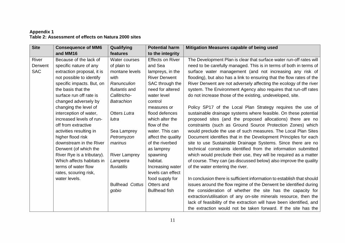
Appendix 1 Table 2: Assessment of effects on Natura 2000 sites
Site Consequence of MM6
and MM16
Qualifying
features
Potential harm
to the integrity
Mitigation Measures capable of being used
River
Derwent
SAC
Because of the lack of
specific nature of any
extraction proposal, it is
not possible to identify
specific impacts. But, on
the basis that the
surface run off rate is
changed adversely by
changing the level of
interception of water,
increased levels of run-
off from extractive
activities resulting in
higher flood risk
downstream in the River
Derwent (of which the
River Rye is a tributary).
Which affects habitats in
terms of water flow
rates, scouring risk,
water levels.
Water courses
of plain to
montane levels
with
Ranunculion
fluitantis and
Callitricho-
Batrachion
Otters Lutra
lutra
Sea Lamprey
Petromyzon
marinus
River Lamprey
Lampetra
fluviatilis
Bullhead Cottus
gobio
Effects on River
and Sea
lampreys, in the
River Derwent
SAC through the
need for altered
water level
control
measures or
flood defences
which alter the
flow of the
water. This can
affect the quality
of the riverbed
as lamprey
spawning
habitat.
Increasing water
levels can effect
food supply for
Otters and
Bullhead fish
The Development Plan is clear that surface water run-off rates will
need to be carefully managed. This is in terms of both in terms of
surface water management (and not increasing any risk of
flooding), but also has a link to ensuring that the flow rates of the
River Derwent are not adversely affecting the ecology of the river
system. The Environment Agency also requires that run-off rates
do not increase those of the existing, undeveloped, site.
Policy SP17 of the Local Plan Strategy requires the use of
sustainable drainage systems where feasible. On these potential
proposed sites (and the proposed allocations) there are no
constraints (such as Ground Source Protection Zones) which
would preclude the use of such measures. The Local Plan Sites
Document identifies that in the Development Principles for each
site to use Sustainable Drainage Systems. Since there are no
technical constraints identified from the information submitted
which would preclude their use, they will be required as a matter
of course. They can (as discussed below) also improve the quality
of the water entering the river.
In conclusion there is sufficient information to establish that should
issues around the flow regime of the Derwent be identified during
the consideration of whether the site has the capacity for
extraction/utilisation of any on-site minerals resource, then the
lack of feasibility of the extraction will have been identified, and
the extraction would not be taken forward. If the site has the

12
Site Consequence of MM6
and MM16
Qualifying
features
Potential harm
to the integrity
Mitigation Measures capable of being used
capacity, embedded mitigation measures would be employed to
require that there was no adverse impacts.
River
Derwent
SAC
Broad Location SD12
(MM16) has potential for
direction connection to
the Derwent and indirect
connection for site SD3
(MM6) Increased levels
of diffuse pollution
through run-off from
developed sites, affects
the water quality
(nutrient and pollutant
content) affecting food
sources
Water courses
of plain to
montane levels
with
Ranunculion
fluitantis and
Callitricho-
Batrachion
Otters Lutra
lutra
Sea Lamprey
Petromyzon
marinus
River Lamprey
Lampetra
fluviatilis
Bullhead Cottus
gobio
Effects on water
quality in the
River Derwent
SAC and Lower
Derwent SAC,
SPA and
RAMSAR sites
could affect the
qualifying
habitats and
species present
in these sites,
as they are also
dependent upon
the high quality
of the water for
their supply of
food.
As part of managing surface water run-off in principle, there is a
need to ensure that techniques employed, and management of
foul/contaminated water, is undertaken to ensure no adverse
impact on the quality of water entering the River Derwent.
Policy SP17 of The Local Plan Strategy, requires applications for
new development assess impacts on water quality and propose
mitigation measures to reduce the risk of pollution and a
deterioration of water quality, and aligned to this ensure that
necessary sewerage and water treatment infrastructure
improvements are provided in tandem with new development.
Policy SP17 requires the use of sustainable drainage systems
where feasible. As discussed in respect of water levels, the use of
SUDs will be expected in principle on the allocations, both manage
run-off and improve water quality. There is no evidence submitted
which demonstrates that they are not feasible, and they have been
added as a development Principle.
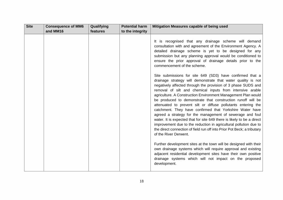
It is recognised that any drainage scheme will demand
consultation with and agreement of the Environment Agency. A
detailed drainage scheme is yet to be designed for any
submission but any planning approval would be conditioned to
ensure the prior approval of drainage details prior to the
commencement of the scheme.

13
Site Consequence of MM6
and MM16
Qualifying
features
Potential harm
to the integrity
Mitigation Measures capable of being used
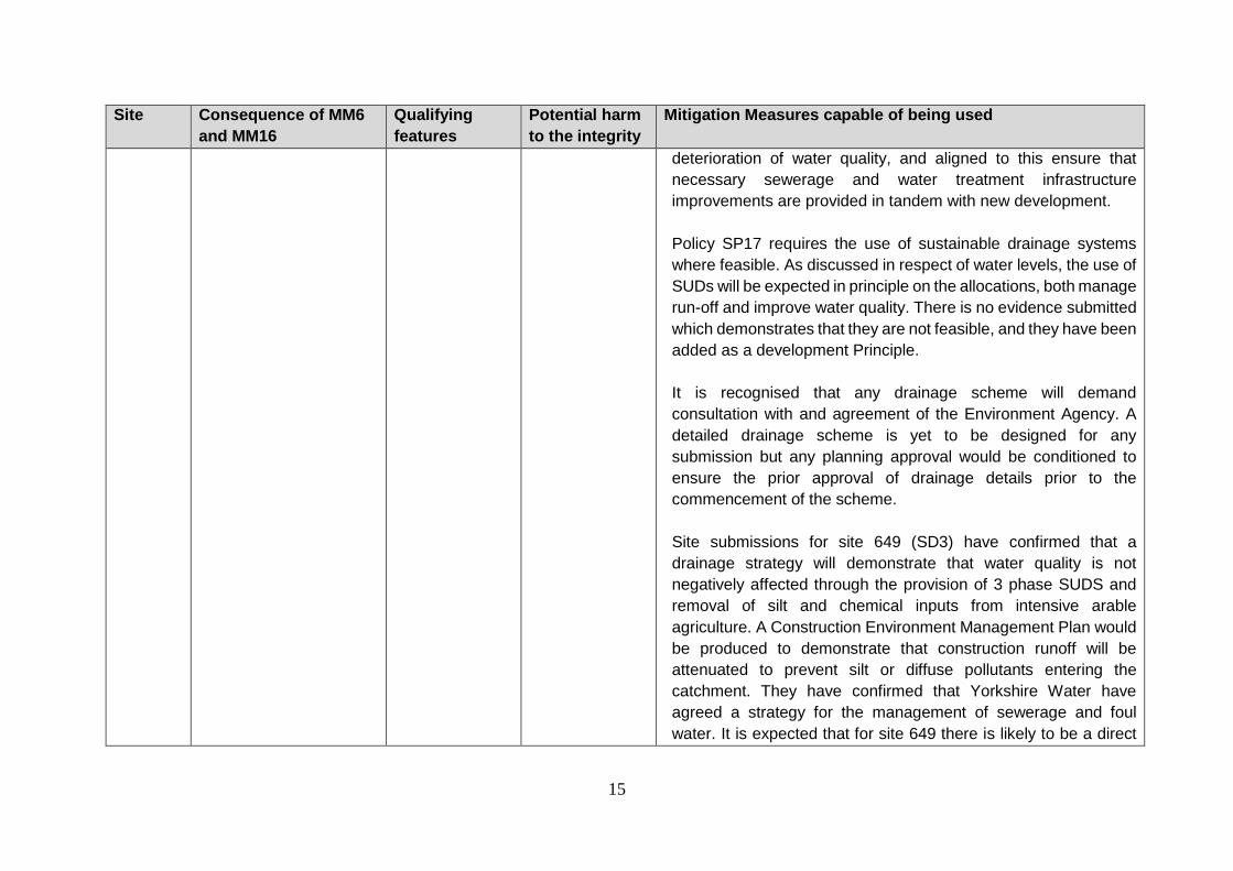
Site submissions for site 649(SD3) have confirmed that a drainage
strategy will demonstrate that water quality is not negatively
affected through the provision of 3 phase SUDS and removal of
silt and chemical inputs from intensive arable agriculture. A
Construction Environment Management Plan would be produced
to demonstrate that construction runoff will be attenuated to
prevent silt or diffuse pollutants entering the catchment. They
have confirmed that Yorkshire Water have agreed a strategy for
the management of sewerage and foul water. It is expected that
for site 649 (SD3) there is likely to be a direct improvement due to
the reduction in agricultural pollution due to the direct connection
of field run off into Prior Pot Beck; a tributary of the River Derwent.
Further development sites at the Town will be designed with their
own drainage systems which will require approval and existing
adjacent residential development sites have their own positive
drainage systems which will not impact on the proposed
development.
Yorkshire Water are aware of the increased pressure on
sewerage and surface water, and that it is factored into their 5-
year rolling capital programme to expand the capacity to
accommodate the levels of development identified in the Local
Plan Strategy. It is also important to note that given the size of
some of the land submissions, they will not be built out en-masse,
and will be phased. Site 649 (SD3) has provided confirmation of

14
Site Consequence of MM6
and MM16
Qualifying
features
Potential harm
to the integrity
Mitigation Measures capable of being used
the principle of Yorkshire Water permitting foul drains to enter into
the main sewerage system.
As to the nature of alterations to the type of contaminants entering
the River; it is considered that there will be a net improvement. All
the original option sites which are being considered as preferred
sites are used in arable farming, and as such the level of nutrient
input and where necessary pesticide control are much greater
than either grazed land, or land which is then taken into a
urbanised context, which is then subjected to various interceptors
for pollutant control.
In conclusion there is sufficient information to assess the principle
of development, for allocation purposes, that drainage schemes
which would meet the requirements of Yorkshire Water and the
Environment Agency can be achieved, which will in turn ensure
that the scheme can be achieved, alone and in combination with
other development, without impacting on the water quality or water
flow in the River Derwent.
Lower
Derwent
SAC
Increased levels of
diffuse pollution through
run-off from developed
sites, affects the water
quality (nutrient and
pollutant content)
affecting food sources
Lowland hay
meadows,
Alluvial forests
with Alnus
glutinosa and
Fraxinus
excelsior, Otters
Lutra lutra
Effects on water
quality from
increased run-
off could affect
the species and
habitats
supported by
the river.
As part of managing surface water run-off in principle, there is a
need to ensure that techniques employed, and management of
foul/contaminated water, is undertaken to ensure no adverse
impact on the quality of water entering the River Derwent.
Policy SP17 of The Local Plan Strategy, requires applications for
new development assess impacts on water quality and propose
mitigation measures to reduce the risk of pollution and a
15
Site Consequence of MM6
and MM16
Qualifying
features
Potential harm
to the integrity
Mitigation Measures capable of being used
deterioration of water quality, and aligned to this ensure that
necessary sewerage and water treatment infrastructure
improvements are provided in tandem with new development.
Policy SP17 requires the use of sustainable drainage systems
where feasible. As discussed in respect of water levels, the use of
SUDs will be expected in principle on the allocations, both manage
run-off and improve water quality. There is no evidence submitted
which demonstrates that they are not feasible, and they have been
added as a development Principle.
It is recognised that any drainage scheme will demand
consultation with and agreement of the Environment Agency. A
detailed drainage scheme is yet to be designed for any
submission but any planning approval would be conditioned to
ensure the prior approval of drainage details prior to the
commencement of the scheme.
Site submissions for site 649 (SD3) have confirmed that a
drainage strategy will demonstrate that water quality is not
negatively affected through the provision of 3 phase SUDS and
removal of silt and chemical inputs from intensive arable
agriculture. A Construction Environment Management Plan would
be produced to demonstrate that construction runoff will be
attenuated to prevent silt or diffuse pollutants entering the
catchment. They have confirmed that Yorkshire Water have
agreed a strategy for the management of sewerage and foul
water. It is expected that for site 649 there is likely to be a direct
16
Site Consequence of MM6
and MM16
Qualifying
features
Potential harm
to the integrity
Mitigation Measures capable of being used
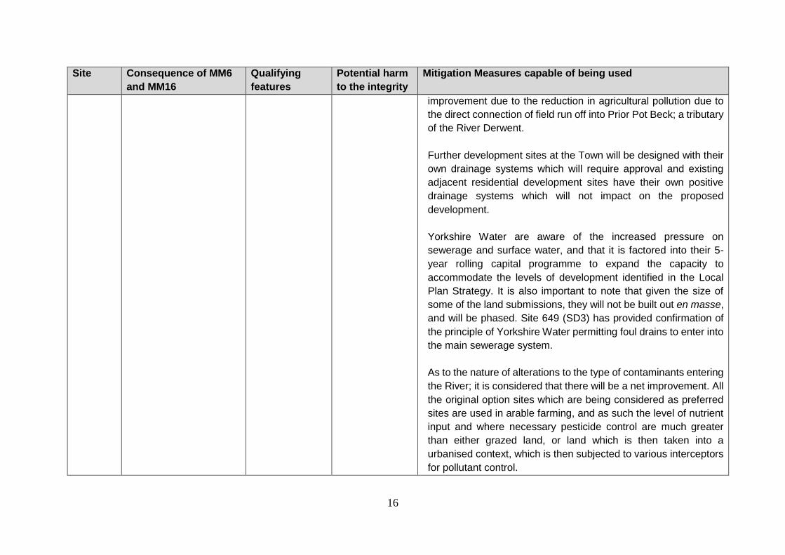
improvement due to the reduction in agricultural pollution due to
the direct connection of field run off into Prior Pot Beck; a tributary
of the River Derwent.
Further development sites at the Town will be designed with their
own drainage systems which will require approval and existing
adjacent residential development sites have their own positive
drainage systems which will not impact on the proposed
development.
Yorkshire Water are aware of the increased pressure on
sewerage and surface water, and that it is factored into their 5-
year rolling capital programme to expand the capacity to
accommodate the levels of development identified in the Local
Plan Strategy. It is also important to note that given the size of
some of the land submissions, they will not be built out en masse,
and will be phased. Site 649 (SD3) has provided confirmation of
the principle of Yorkshire Water permitting foul drains to enter into
the main sewerage system.
As to the nature of alterations to the type of contaminants entering
the River; it is considered that there will be a net improvement. All
the original option sites which are being considered as preferred
sites are used in arable farming, and as such the level of nutrient
input and where necessary pesticide control are much greater
than either grazed land, or land which is then taken into a
urbanised context, which is then subjected to various interceptors
for pollutant control.

17
Site Consequence of MM6
and MM16
Qualifying
features
Potential harm
to the integrity
Mitigation Measures capable of being used
In conclusion there is sufficient information to assess the principle
of development, for allocation purposes, that drainage schemes
which would meet the requirements of Yorkshire Water and the
Environment Agency can be achieved, which will in turn ensure
that the scheme can be achieved, alone and in combination with
other development, without impacting on the water quality or water
flow in the River Derwent, and consequently the Lower Derwent
SPA.
Lower
Derwent
SPA
Increased levels of
diffuse pollution through
run-off from developed
sites, affects the water
quality (nutrient and
pollutant content)
affecting food sources
Bewick’s swan
Eurasian
wigeon
Eurasian teal
Northern
shoveler
European
golden plover
Ruff
Waterbird
assemblage
Great bittern
Spotted crake
Corn crake
Effects on water
quality from
increased run-
off could affect
the species and
habitats
supported by
the river.
As part of managing surface water run-off in principle, there is a
need to ensure that techniques employed, and management of
foul/contaminated water, is undertaken to ensure no adverse
impact on the quality of water entering the River Derwent.
Policy SP17 of The Local Plan Strategy, requires applications for
new development assess impacts on water quality and propose
mitigation measures to reduce the risk of pollution and a
deterioration of water quality, and aligned to this ensure that
necessary sewerage and water treatment infrastructure
improvements are provided in tandem with new development.
Policy SP17 requires the use of sustainable drainage systems
where feasible. As discussed in respect of water levels, the use of
SUDs will be expected in principle on the allocations, both manage
run-off and improve water quality. There is no evidence submitted
which demonstrates that they are not feasible, and they have been
added as a development Principle.
18
Site Consequence of MM6
and MM16
Qualifying
features
Potential harm
to the integrity
Mitigation Measures capable of being used
It is recognised that any drainage scheme will demand
consultation with and agreement of the Environment Agency. A
detailed drainage scheme is yet to be designed for any
submission but any planning approval would be conditioned to
ensure the prior approval of drainage details prior to the
commencement of the scheme.
Site submissions for site 649 (SD3) have confirmed that a
drainage strategy will demonstrate that water quality is not
negatively affected through the provision of 3 phase SUDS and
removal of silt and chemical inputs from intensive arable
agriculture. A Construction Environment Management Plan would
be produced to demonstrate that construction runoff will be
attenuated to prevent silt or diffuse pollutants entering the
catchment. They have confirmed that Yorkshire Water have
agreed a strategy for the management of sewerage and foul
water. It is expected that for site 649 there is likely to be a direct
improvement due to the reduction in agricultural pollution due to
the direct connection of field run off into Prior Pot Beck; a tributary
of the River Derwent.
Further development sites at the town will be designed with their
own drainage systems which will require approval and existing
adjacent residential development sites have their own positive
drainage systems which will not impact on the proposed
development.
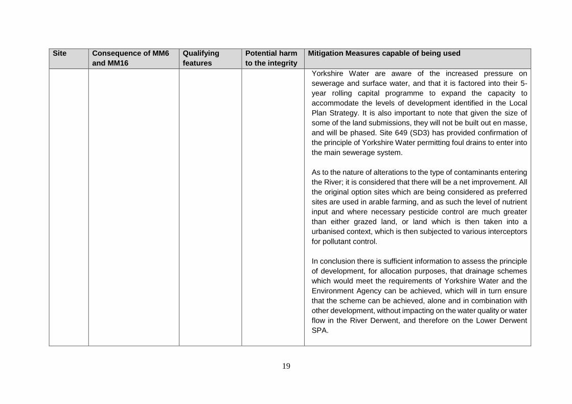
19
Site Consequence of MM6
and MM16
Qualifying
features
Potential harm
to the integrity
Mitigation Measures capable of being used
Yorkshire Water are aware of the increased pressure on
sewerage and surface water, and that it is factored into their 5-
year rolling capital programme to expand the capacity to
accommodate the levels of development identified in the Local
Plan Strategy. It is also important to note that given the size of
some of the land submissions, they will not be built out en masse,
and will be phased. Site 649 (SD3) has provided confirmation of
the principle of Yorkshire Water permitting foul drains to enter into
the main sewerage system.
As to the nature of alterations to the type of contaminants entering
the River; it is considered that there will be a net improvement. All
the original option sites which are being considered as preferred
sites are used in arable farming, and as such the level of nutrient
input and where necessary pesticide control are much greater
than either grazed land, or land which is then taken into a
urbanised context, which is then subjected to various interceptors
for pollutant control.
In conclusion there is sufficient information to assess the principle
of development, for allocation purposes, that drainage schemes
which would meet the requirements of Yorkshire Water and the
Environment Agency can be achieved, which will in turn ensure
that the scheme can be achieved, alone and in combination with
other development, without impacting on the water quality or water
flow in the River Derwent, and therefore on the Lower Derwent
SPA.

20
Site Consequence of MM6
and MM16
Qualifying
features
Potential harm
to the integrity
Mitigation Measures capable of being used
Lower
Derwent
RAMSAR
Increased levels of
diffuse pollution through
run-off from developed
sites, affects the water
quality (nutrient and
pollutant content)
affecting food sources
Internationally
important
wetland
assemblage –
plants,
invertebrates
Effects on water
quality from
increased run-
off could affect
the species and
habitats
supported by
the river.
As part of managing surface water run-off in principle, there is a
need to ensure that techniques employed, and management of
foul/contaminated water, is undertaken to ensure no adverse
impact on the quality of water entering the River Derwent.
Policy SP17 of The Local Plan Strategy, requires applications for
new development assess impacts on water quality and propose
mitigation measures to reduce the risk of pollution and a
deterioration of water quality, and aligned to this ensure that
necessary sewerage and water treatment infrastructure
improvements are provided in tandem with new development.
Policy SP17 requires the use of sustainable drainage systems
where feasible. As discussed in respect of water levels, the use of
SUDs will be expected in principle on the allocations, both manage
run-off and improve water quality. There is no evidence submitted
which demonstrates that they are not feasible, and they have been
added as a development Principle.
It is recognised that any drainage scheme will demand
consultation with and agreement of the Environment Agency. A
detailed drainage scheme is yet to be designed for any
submission but any planning approval would be conditioned to
ensure the prior approval of drainage details prior to the
commencement of the scheme.
Site submissions for site 649 (SD3) have confirmed that a
drainage strategy will demonstrate that water quality is not
21
Site Consequence of MM6
and MM16
Qualifying
features
Potential harm
to the integrity
Mitigation Measures capable of being used
negatively affected through the provision of 3 phase SUDS and
removal of silt and chemical inputs from intensive arable
agriculture. A Construction Environment Management Plan would
be produced to demonstrate that construction runoff will be
attenuated to prevent silt or diffuse pollutants entering the
catchment. They have confirmed that Yorkshire Water have
agreed a strategy for the management of sewerage and foul
water. It is expected that for site 649 there is likely to be a direct
improvement due to the reduction in agricultural pollution due to
the direct connection of field run off into Prior Pot Beck; a tributary
of the River Derwent.
Further development sites at the Town will be designed with their
own drainage systems which will require approval and existing
adjacent residential development sites have their own positive
drainage systems which will not impact on the proposed
development.
Yorkshire Water are aware of the increased pressure on
sewerage and surface water, and that it is factored into their 5-
year rolling capital programme to expand the capacity to
accommodate the levels of development identified in the Local
Plan Strategy. It is also important to note that given the size of
some of the land submissions, they will not be built out en masse,
and will be phased. Site 649 (SD3) has provided confirmation of
the principle of Yorkshire Water permitting foul drains to enter into
the main sewerage system.

22
Site Consequence of MM6
and MM16
Qualifying
features
Potential harm
to the integrity
Mitigation Measures capable of being used
As to the nature of alterations to the type of contaminants entering
the River; it is considered that there will be a net improvement. All
the original option sites which are being considered as preferred
sites are used in arable farming, and as such the level of nutrient
input and where necessary pesticide control are much greater
than either grazed land, or land which is then taken into a
urbanised context, which is then subjected to various interceptors
for pollutant control.
In conclusion there is sufficient information to assess the principle
of development, for allocation purposes, that drainage schemes
which would meet the requirements of Yorkshire Water and the
Environment Agency can be achieved, which will in turn ensure
that the scheme can be achieved, alone and in combination with
other development, without impacting on the water quality or water
flow in the River Derwent, and therefore no impact on the Lower
Derwent RAMSAR.