Habitats Regulations Assessment Baseline and Methodology...
74
Central and Eastern Berkshire Authorities Joint Minerals & Waste Plan Habitats Regulations Assessment Baseline and Methodology Report Revised (June 2017)
Transcript of Habitats Regulations Assessment Baseline and Methodology...

Central and Eastern Berkshire Authorities
Joint Minerals & Waste Plan
Habitats Regulations Assessment
Baseline and Methodology Report
Revised (June 2017)

Intentionally Blank

Contents 1. Introduction .......................................................................................................... 1
Scope ...................................................................................................................... 1
Legislation ............................................................................................................... 1
The Joint Minerals & Waste Plan - Plan Area ......................................................... 2
2. HRA Methodology................................................................................................ 4
The HRA Process ................................................................................................... 4
Timing of the HRA and integration with plan preparation ........................................ 7
Scale and level of detail .......................................................................................... 9
Limitations and assumptions ................................................................................... 9
3. Undertaking the HRA ......................................................................................... 11
Stage 1: Screening for significant effects .............................................................. 11
Amending the plan/option ..................................................................................... 16
In combination effects ........................................................................................... 17
Consulting on the results of the screening stage .................................................. 18
Stage 2: Appropriate Assessment ......................................................................... 19
Consulting on the scope of the Appropriate Assessment .................................. 20
Amending the plan/option .................................................................................. 20
Measures to ensure no adverse effects ............................................................. 20
Consulting on the HRA Record .......................................................................... 21
4. EU Sites within the Plan Area ............................................................................ 23
European site locations ......................................................................................... 23
Potential European site designations .................................................................... 27
5. Condition and Conservation Status of the European sites ................................. 28
Conservation objectives for the European Sites ................................................... 28
Condition of European sites .................................................................................. 28
European site features and sensitivities ................................................................ 30
Further information required.................................................................................. 30
6. Existing pressures and management issues on the sites .................................. 31
Current European site issues relating to existing development............................. 31
Current management of European sites ............................................................... 31
7. Potential effects on European sites ................................................................... 32
Understanding potential effects ............................................................................. 32

Issues potentially affecting European sites ........................................................... 32
Further information required.................................................................................. 34
Need for further data or surveys ........................................................................... 34
APPENDICES .......................................................................................................... 35
Appendix A: European Sites Fact Files ................................................................. 35
Appendix B: Conservation Objectives ................................................................... 41
Appendix C: European Sites: SSSI units .............................................................. 46
Appendix D: European SSSI Site Conditions ........................................................ 48
Appendix E: European site vulnerabilities and sensitivities ................................... 58
Appendix F: Correspondence from Natural England ............................................. 62
Appendix G: Glossary ........................................................................................... 66
Prepared by Hampshire Services
Hampshire County Council
www.hants.gov.uk/sharedexpertise

Habitats Regulations Assessment: Baseline and Methodology Report – Revised (June 2017) Page 1
1. Introduction
Scope
1.1 The purpose of this report is to set out the methodology and baseline evidence
that will be used to undertake a Habitat Regulations Assessment (HRA) of the
Joint Minerals & Waste Plan for the Central and Eastern Berkshire Authorities.
The objective of the HRA will be to identify any aspects of the plan that would
have the potential to cause a likely significant effect on ‘European sites’ either
alone or in combination with other plans and projects, and thereby affect the
integrity of those sites, and to devise appropriate mitigation strategies where
such effects are identified.
Legislation
1.2 The need for HRA, sometimes also referred to as Appropriate Assessment or
AA is set out within Article 6 of the EC Habitats Directive 19921, transposed into
UK law by the Conservation of Habitats & Species Regulations 2010 (Habitats
Regulations)2. The ultimate aim of the Habitats Directive is to “maintain or
restore, at favourable conservation status, natural habitats and species of wild
fauna and flora of community interest” (Habitats Directive, Article 2(2)). This
aim relates to habitats and species, not the ‘European sites’, although the sites
have a significant role in delivering favourable conservation status.
1.3 Regulations 102 to 105 of the Habitats Regulations require competent
authorities to asses the effects of ‘land use plans’ on European sites. This
requirement applies to Local Development Documents (LDD) including
Development Plan Documents (DPDs). The Central and Eastern Berkshire -
Joint Minerals & Waste Plan is a DPD and is therefore subject to HRA.
1.4 Under Regulation 102, the assessment must determine whether or not a plan
will adversely affect the integrity of the European site(s) concerned, either
alone or in combination with other plans and projects. Plans can only be
permitted having ascertained that there will be no adverse effect on the
integrity of the site(s) in question. Where effects on ecological integrity are
identified, plan makers must first consider alternative ways of achieving the
plan’s objectives that avoid significant effects entirely. Where it is not
possible to meet objectives through other means, mitigation measures that
allow the plan to proceed by removing or reducing significant effects may be
considered. If it is impossible to avoid or mitigate the adverse effect, the plan-
1 Council Directive 92/43/EEC on the Conservation of natural habitats and of wild fauna and flora. 2 The Conservation of Habitats and Species Regulations 2010.

Habitats Regulations Assessment: Baseline and Methodology Report – Revised (June 2017) Page 2
makers must demonstrate, under the conditions of Regulation 103 of the
Habitats Regulations, that there are Imperative Reasons of Overriding Public
Interest (IROPI) to continue with the proposal. In such cases, compensation
would be necessary to ensure the overall integrity of the site network. This is
widely perceived as an undesirable position and should be avoided if at all
possible.
1.5 The Habitats Directive applies the precautionary principle to the
consideration of European sites in HRA. Any uncertainty over the precise
nature and/or magnitude of the adverse effects should be thoroughly tested.
Where appropriate, a precautionary approach should be adopted and the
assessment of adverse effect based on a worse-case scenario applied.
1.6 HRA is undertaken by the Competent Authority, which is the authority that
has legally delegated powers of authority under Article 6(3) of the Habitats
Directive. In the case of the Joint Minerals & Waste Plan, Bracknell Forest
Council, Reading Borough Council, Royal Borough for Windsor &
Maidenhead and Wokingham Borough Council are the minerals and waste
planning authorities for the plan area, and as such are the competent
authorities for this HRA.
1.7 In line with legislation, Government policy3 and guidance, the term ‘European
sites’ referred to in this report includes:
Special Areas of Conservation (SAC), designated under the Habitats
Directive;
Special Protection Areas (SPA) classified under the Birds Directive4;
Ramsar sites, listed under the Convention on Wetlands of International
Importance;
Sites that are being considered for designation referred to as Sites of
Community Interest, candidate SACs or proposed SPAs;
Sites identified or required as compensatory measures for adverse
effects on statutory European sites and Ramsar sites,
1.8 The network of European sites is collectively known as Natura 2000. The aim
of Natura 2000 is to ensure the long-term survival of Europe's most valuable
and threatened species and habitats.
The Joint Minerals & Waste Plan - Plan Area
1.9 Bracknell Forest Council, Reading Borough Council, the Royal Borough of
Windsor and Maidenhead and Wokingham Borough Council (collectively
3 Paragraph 118 of the National Planning Policy Framework (NPPF)
4 Directive 2009/147/EC on the conservation of wild birds

Habitats Regulations Assessment: Baseline and Methodology Report – Revised (June 2017) Page 3
referred to as the ‘Central & Eastern Berkshire Authorities’) are working in
partnership to produce a Joint Minerals & Waste Plan which will guide minerals
and waste decision-making in the Plan area.
1.10 The Joint Minerals & Waste Plan will build upon the formerly adopted minerals
and waste plans for the Berkshire area, and improve, update and strengthen
the policies and provide details of strategic sites that are proposed to deliver
the vision.
1.11 This is important as out of date plans limit the ability for planning authorities to
enable the right development, in the right location, at the right time, and may
lead to a greater number of planning applications determined at appeal.
1.12 Mineral and waste planning issues are most appropriately addressed jointly so
that strategic issues can be satisfactorily resolved. The Plan will cover the
minerals and waste planning authority administrative areas of Bracknell Forest,
Reading, Windsor & Maidenhead and Wokingham (see Figure 1).
Figure 1: Central & Eastern Berkshire Authorities administrative areas

Habitats Regulations Assessment: Baseline and Methodology Report – Revised (June 2017) Page 4
2. HRA Methodology
2.1 The HRA is being undertaken without the benefit of up to date guidance in
England for the preparation of HRAs. Therefore, the HRA methodology and
processes set out in this report are based on those set out in the Habitats
Regulations Assessment Handbook5. The guidance is non-statutory, but “based
on experience, good practice and authoritative published guidance”. It is also
kept up-to-date.
2.2 As the Joint Minerals & Waste Plan is not directly connected with or necessary
to the nature conservation management of European sites and as the Joint
Minerals & Waste Plan is a land use plan, the plan will be subject to HRA. This
conclusion will be confirmed and recorded as part of the initial ‘screening’
process.
The HRA Process
2.3 The four stage approach to Habitats Regulations Assessment set out in ‘The
Habitats Regulations Assessment Handbook’ is summarised in Figure 2.
5 Tyldesley, D. and Chapman, C., (2013) The Habitats Regulations Assessment Handbook, May 2015 edition
(DTA Publications Ltd: Berkshire)

Habitats Regulations Assessment: Baseline and Methodology Report – Revised (June 2017) Page 5
Figure 2: Four stage approach to HRA (taken from The Habitats Regulations Assessment Handbook)
2.4 Further detail about the four stage approach to the assessment of plans under
the Habitats Regulations is provided in Figure 3.
Stage 2: Appropriate Assessment and the Integrity Test
Undertaking an ‘appropriate assessment’ and ascertaining that the plan would not have a
significant adverse effect on the integrity of the European site(s). The competent authorities
may agree to the plan if it will not adversely affect the integrity of European site(s).
Stage 1: Screening
Screening the plan and its components to see if it would be likely to have a significant effect on
a European site(s). If the plan is found not likely to have significant effect on European site(s) it
will be ‘screened out’ of the need for any further assessment.
Stage 3: Alternative Solutions
Deciding whether there are alternative solutions which would avoid or have a lesser effect on
the European site(s). If there are alternative solutions, a potentially damaging plan or project
cannot be agreed to; it will need to be changed or refused.
Stage 4: Imperative reasons of overriding public interest and compensatory measures
Considering imperative reasons or overriding public interest and securing compensatory
measures. The plan may proceed for imperative reasons of overriding public interest if
compensatory measures are secured.
Evidence gathering

Habitats Regulations Assessment: Baseline and Methodology Report – Revised (June 2017) Page 6
Figure 3: Outline of the four stage approach to the assessment of Plans under the Habitats Regulations
Article 6(3)
(Regulation 61 or 102)
Article 6(4)
(Regulation 62 & 66 or 103 & 105)
Stage 1:
Screening for likely
significant effects
Stage 2:
Appropriate
Assessment (AA)
and the Integrity
Test
Stage 3:
Alternative
Solutions
Stage 4:
Imperative reasons
or overriding public
interest (IROPI) and
compensatory
measures
Can plan be
exempted, excluded
or eliminated?
Gather information
about the European
sites.
Consider changes that
might avoid or reduce
effects.
Initial screening for
likely significant
effects, either alone
or in combination.
Consider additional
mitigation measures
and rescreen plan.
Agree the scope and
methodology of AA.
Undertake AA.
Apply the integrity
test, considering
further mitigation
where required.
Embed further
mitigation into plan.
Consult statutory
body and others.
Is it possible to
ascertain no adverse
effect on integrity?
Identify underlying
need for the plan?
Identify whether
alternative solutions
exist that would
achieve the objectives
of the plan and have
no, or a lesser affect
on the European
site(s)?
Are they financially,
legally and technically
feasible?
Is the risk and harm to
the site overridden by
imperative reasons of
public interest (taking
account of ‘priority’
features where
appropriate)?
Identify and prepare
delivery of all
necessary
compensatory
measures to protect
overall coherence of
Natura 2000 network.
Notify Government.
Assessment is
complete IF
Plan has no likely
significant effect
either alone or in
combination with
plans or projects:
Plan can be adopted
Assessment is
complete IF
Plan has no adverse
effect on integrity of
any European site,
either alone or in
combination:
Plan can be adopted
Assessment ends IF
There are alternative
solutions to the plan:
Plan cannot be
adopted without
modification
Assessment is
complete: Either
A] there are IROPI
and compensatory
measures: Plan can
be adopted
B] if not, Plan cannot
be adopted
Adapted from The Habitats Regulations Assessment Handbook, www.dtapublications.co.uk
© DTA Publications Limited (September 2013) All rights reserved.

Habitats Regulations Assessment: Baseline and Methodology Report – Revised (June 2017) Page 7
2.5 If the screening stage concludes that there are likely to be no significant
impacts on European sites then there is no need to progress to the stage of
Appropriate Assessment.
2.6 Judgement of the significance of effects on European sites should be
undertaken in relation to the designated interest features and conservation
objective of the site in question using sound judgement and with a scientific
basis where available. If insufficient information is available to make a clear
judgement, it should be assumed that a significant effect is possible in line with
the precautionary principle.
2.7 Natural England will be consulted to ensure that the HRA process is
considering all the potential impacts that may affect the sites (and the
management objectives for each site).
Timing of the HRA and integration with plan preparation
2.8 The HRA assessment process will be undertaken in parallel with the
preparation of the Joint Minerals & Waste Plan in order that the HRA can inform
the development of the plan, and ensure that the plan does not include general
or specific proposals which may fail the Habitats Regulations tests at the
project application stage. Regulation 102(1) provides that, where necessary, an
appropriate assessment must be made ’before the plan is given effect’ and
Regulation 61(1) requires a competent authority to make an appropriate
assessment before deciding to undertake or agree to a plan. Natural England
and other relevant stakeholders will be consulted throughout the HRA
assessment process.
2.9 The HRA assessment process will also be undertaken concurrently with the
Strategic Environment Assessment (SEA) / Sustainability Assessment (SA) of
the Joint Minerals & Waste Plan. Although this is a different process, guidance
suggests that procedural requirements can be 'meshed'. The Central and
Eastern Berkshire Authorities will document the initial 'screening' of policy
options under the Habitats Regulations Assessment in parallel with the SA.
Natural England and the Environment Agency are key consultees for the SA
process and will, therefore, be engaged as the policy options are generated
and assessed under SA, and then screened as part of the HRA process. The
findings from the screening stage will be documented alongside the relevant SA
Report.
2.10 Figure 4 sets out how the main stages of plan preparation and HRA
assessment will integrate.

Habitats Regulations Assessment: Baseline and Methodology Report – Revised (June 2017) Page 8
Figure 4: Relationship of steps in the HRA with a typical plan-making process
Preliminary SEA / SA
/ HRA outcomes.
PLAN PROCESS STEPS IN THE HABITATS REGULATIONS ASSESSMENT PROCESS
Decide whether plan is exempt or can be excluded or eliminated from assessment.
Gathering the
evidence base and
initial preparations /
engagement.
Generating and
testing options.
First draft of the
plan.
Testing further
options.
Improving the plan.
Early consultations.
Responding to SEA /
SA / HRA.
Finalising the Draft /
Proposed Plan.
Publish Draft /
Proposed Plan.
Scan for and select the European sites to be
considered in the assessment.
Gathering information on European sites required for
assessment.
Checking the plan’s emerging strategy and objectives
and analysis of options.
Preliminary screening of the first full draft plan
Re-screening the plan after mitigation measures
applied.
Incorporating initial mitigation measures
If significant effects still likely. If significant effects unlikely after mitigation.
Selecting relevant
European sites.
Gathering evidence.
Testing strategy and
options.
Preliminary screening
for effects.
Engaging the
statutory body and
other stakeholders as
necessary.
Amend plan in light
of comments and any
‘examination’.
Iterative process of
mitigation
Undertake an appropriate assessment in view of conservation objectives.
Apply mitigation measures until there is no adverse effect on site integrity.
Prepare a draft record of the HRA. Consult statutory body (& other stakeholders
and the public if appropriate) on draft HRA.
Screen any amendments for likelihood of significant effects and carry out appropriate
assessment if required, re-consult statutory body if necessary on amendments.
Modify HRA record in light of consultation and representations and any amendments to
the plan and complete and publish final / revised HRA record with clear conclusions.
Plan making body
gives effect to the
plan.
Adapted from The Habitats Regulations Assessment Handbook, www.dtapublications.co.uk
© DTA Publications Limited (September 2013) All rights reserved.

Habitats Regulations Assessment: Baseline and Methodology Report – Revised (June 2017) Page 9
Scale and level of detail
2.11 It is recognised by the European and UK courts and the European
Commission that the assessment of a plan may not be as precise and
detailed as that of a project at application stage. The method and level of
detail required of this HRA is dependent on the scale and geographic area of
the plan, the nature of its policies, and how European sites may be affected
as a result. The competent authorities are responsible to ensure the
assessment is appropriate and compliant.
2.12 The method selected for assessing the Joint Minerals & Waste Plan is a
judgement which may be limited or refined by the information available. Such
limitations are outlined below. Natural England will be engaged throughout
the stages of HRA, and will be consulted by the competent authorities on the
appropriate method, scale and level of detail.
Limitations and assumptions
2.13 There will usually be limitations on the prediction of effects, and the degree of
risk that can then be forecast, for example, those relating to:
The level of detail and stage of the plan;
The information available at the time about the qualifying features,
including habitat composition, distribution or extent, or species’
population, abundance, distribution, mobility or behaviour etc;
The age, type or format of data;
Availability or accessibility of data;
Timescales and seasonal restrictions;
Scientific know-how or techniques;
Scientific understanding of natural processes and ecosystems;
Ecological understanding of likely responses;
Experience and prior knowledge about the particular effects;
Outcomes of trials or experiments;
The availability of information from monitoring the effects of past plans
and projects.
2.14 These limitations may need to be overcome by additional surveys,
investigations or research. It follows that there are likely to be differing levels
of certainty or confidence in the predictions as to both the characteristics of
the effects and the risk of them occurring. If assumptions, which strongly
influence the outcome of the assessment, need to be made about the plan or
the qualifying features, or the effects of risks, they should be stated in the
assessment record. In cases where effects on a sites’ integrity are uncertain,
the assessment should consider how adopting different assumptions might

Habitats Regulations Assessment: Baseline and Methodology Report – Revised (June 2017) Page 10
vary the outcome of the assessment. This will test the sensitivity of the
assessment outcomes to the use of different assumptions.
2.15 HRA is underpinned by the precautionary principle, whereby the Competent
Authority acts to avoid potential harm in the face of scientific uncertainty. If it
is not possible in a 'likely significant effect' test to rule out a risk of significant
effect on a European site on the basis of available evidence, then it should
be assumed a risk may exist and needs to be addressed at the next stage of
HRA. The precautionary approach should be exercised at all stages of the
assessment.

Habitats Regulations Assessment: Baseline and Methodology Report – Revised (June 2017) Page 11
3. Undertaking the HRA
3.1 In order to assess the effects of the Joint Minerals & Waste Plan on
European sites, the overall scale, location, timing and nature of development
proposed by the plan will need to be considered. Guidance suggests
assessment should be confined to the development and land use changes
proposed in the plan.
Stage 1: Screening for significant effects
3.2 The objective of this stage of the HRA is to ‘screen out’ elements of the plan
that cannot have any significant effect on the any European site, either alone
or in combination with other plans or projects; and to identify any aspects of
the plan which could have such an effect, so that mitigation measures can be
considered. It may be that the whole of the plan can be screened out and no
further assessment is required.
3.3 A screening schedule and matrix will be used to systematically screen each
relevant component of the plan, including vision, goals, objectives, policies,
proposals and supporting text, dependent on how the plan is set out. The
screening schedule will be agreed with Natural England.
3.4 To determine if the proposals are likely to have any significant effects on
European sites the following issues are considered:
• could the proposals affect the qualifying interest of the European site
and is the site sensitive to the effect;
• the probability of the effect happening;
• the likely consequences for the site’s Conservation Objectives (as
defined by Natural England) if the effect occurred; and
• the magnitude, duration and reversibility of the effect.
3.5 The following European cases have established what is meant by a ‘likely
significant effect’.
3.6 Significance
A common definition of ‘significant effect’ is as follows: “…any effect that may
reasonably be predicted as a consequence of a plan or project that may
affect the conservation objectives of the features for which the site was
designated, but excluding trivial or inconsequential effects”6.
6 English Nature (1999) Habitats Regulation Guidance Note 3: The Determination of Likely Significant Effect under The
Conservation (Natural Habitats &c) Regulations 1994.

Habitats Regulations Assessment: Baseline and Methodology Report – Revised (June 2017) Page 12
In the Waddenzee ruling the European Court of Justice (ECJ) ruled that a
significant effect is one which undermines the conservation objectives of the
European site, for example displaces the species for which the site is
designated. An effect which does not undermine the conservation objectives
of a site, such a low-impact temporary effect, or trivial or inconsequential
effects cannot be deemed significant.
3.7 Likelihood
The ECJ also ruled in the Waddenzee case that an effect should be deemed
likely only “if it cannot be excluded, on the basis of objective information, that
it will have a significant effect on the site, either individually or in combination
with other plans and projects”. This establishes that ‘likely’ should not be
interpreted as only ‘probable’ or ‘more likely than not’. Rather an effect
should be considered likely if it cannot be ruled out on the basis of objective
information.
3.8 The likelihood of an effect occurring should be considered on a case-by-case
judgment, taking account of the precautionary principle and the local
circumstances of the site.
3.9 In the context of minerals and waste planning, plans may adversely affect a
European site due to the location of change. It may also contain policies or
proposals that provide for, or steer, development within the boundary of, or
within close proximity to a European site. Minerals and waste operations may
have direct or indirect affects on European sites (see Tables 7 and 8).
Indirect affects may be caused by ecological, hydrological or physical links
between operations and European sites.
3.10 The key steps for Stage 1 (screening) are set out in the flow chart below
(Figure 5).

Habitats Regulations Assessment: Baseline and Methodology Report – Revised (June 2017) Page 13
Figure 5: Outline of the Screening steps
3.11 In order to compile the screening matrix, each element of the plan will be
categorised on its likely effects on each interest feature of each European
site identified in the evidence base. There are four categories of potential
effects as follows:
A. Elements of the plan/options that would have no negative effect on a European
site at all.
B. Elements of the plan/options that could have an effect, but the likelihood is there
would be no significant negative effect on a European site either alone or in
combination with other elements of the same plan, or other plans or projects.
Is the plan exempt from assessment?
Preliminary consultations
Recording the assessment
Is the plan excluded from assessment?
Can the plan obviously be eliminated from further assessment?
Gathering information about the European sites potentially affected
Checking the plan’s strategy, analysis of options
Preliminary screening for likely significant effects either alone or in combination
Considering and incorporating further mitigation
measures
Re-screening after further measures incorporated
Adapted from The Habitats Regulations Assessment Handbook, www.dtapublications.co.uk
© DTA Publications Limited (September 2013) All rights reserved.

Habitats Regulations Assessment: Baseline and Methodology Report – Revised (June 2017) Page 14
C. Elements of the plan/options that could or would be likely to have a significant
effect alone and will require the plan to be subject to an appropriate assessment
before the plan may be adopted.
D. Elements of the plan/options that would be likely to have a significant effect in
combination with other elements of the same plan, or other plans or projects and
will require the plan to be subject to an appropriate assessment before the plan may
be adopted.
3.12 Categories A, C and D are further subdivided to provide transparency in
relation to the decision making process, and more directly relate to the ways
in which the plan may affect the European site(s).
Table 1: Potential effects of components of the plan: Category A and B (No negative effect/ significant effects)
Category A1 Options / policies that will not themselves lead to development e.g. because they relate to design or other qualitative criteria for development, or they are not a land use planning policy.
Category A2 Options / policies intended to protect the natural environment, including biodiversity.
Category A3 Options / policies intended to conserve or enhance the natural, built or historic environment, where enhancement measures will not be likely to have any negative effect on a European site (e.g. restoration).
Category A4 Options / policies that positively steer development away from European sites and associated sensitive areas.
Category A5
Options / policies that would have no effect because no development could occur through the policy itself, the development being implemented through later policies in the same plan, which are more specific and therefore more appropriate to assess for their effects on European sites and associated sensitive areas.
Category B Options/ policies could have an effect but the effect would not be likely to have a significant (negative) effect on a European sites (i.e. trivial or 'de minimis' effects).
Table 2: Potential effects of components of the plan: Category C (Likely significant effect alone)
Category C1 The option, policy or proposal could directly affect a European site because it provides for, or steers, a quantity or type of development onto a European site, or adjacent to it.
Category C2
The option, policy or proposal could indirectly affect a European site e.g. because it provides for, or steers, a quantity or type of development that may be very close to it, or ecologically, hydrologically or physically connected to it or it may increase disturbance as a result of increased recreational pressures.

Habitats Regulations Assessment: Baseline and Methodology Report – Revised (June 2017) Page 15
Category C3 Proposals for a magnitude of development that, no matter where it was located, the development would be likely to have a significant effect on a European site.
Category C4
An option, or policy that makes provision for a quantity / type of development (and may indicate one or more broad locations), but the effects are uncertain because the detailed location of the development is to be selected following consideration of options in a later, more specific plan. (This does not apply to the Joint Minerals & Waste Plan because lower-tier 'site allocation plans' are not being prepared).
Category C5
Options, policies or proposals for developments or infrastructure projects that could block options or alternatives for the provision of other development or projects in the future, which will be required in the public interest, that may lead to adverse effects on European sites, which would otherwise be avoided.
Category C6
Options, policies or proposals which depend on how the policies etc are implemented in due course, for example, through the development management process. There is a theoretical possibility that if implemented in one or more particular ways, the proposal could possibly have a significant effect on a European site.
Category C7 Any other options, policies or proposals that would be vulnerable to fail the assessment under the Habitats Regulations at project assessment stage.
Category C8
Any other proposal that may have an adverse effect on a European site, which might try to pass the tests of the Habitats Regulations at project assessment stage by arguing that the plan provides the imperative reasons of overriding public interest to justify its consent despite a negative assessment. (This does not apply to the Joint Minerals & Waste Plan since there are no reserves of national importance in the plan area, and waste management is a local matter).
Table 3: Potential effects of components of the plan: Category D (Likely significant effect in combination)
Category D1
The option, policy or proposal alone would not be likely to have significant effects but if its effects are combined with the effects of other policies or proposals provided for by the plan the cumulative effects would be likely to be significant.
Category D2
Options, policies or proposals that alone would not be likely to have significant effects but if their effects are combined with the effects of other plans or projects, the combined effects would be likely to be significant.
Category D3
Options or proposals that are, or could be, part of a programme or sequence of development delivered over a period, where the implementation of the early stages would not have a significant effect on European sites, but which would dictate the nature, scale, duration, location, timing of the whole project, the later stages of which could have an adverse effect on such sites.
3.13 A summary schedule will be prepared to justify and record the reasons for a
plan element or option being placed into one of the categories above, and to
provide steer for further iterations of the screening stages or further

Habitats Regulations Assessment: Baseline and Methodology Report – Revised (June 2017) Page 16
appropriate assessment.
3.14 Table 4 provides a template of the screening matrix which will be completed
for the Joint Minerals & Waste Plan.
Table 4: Screening Matrix template
Reference (option or policy etc)
Brief description of the option/
policy
Assessment Category
Can the element be changed at screening
stage to avoid
likely significant effect
Is an Appropriate Assessment
required?
[Name and reference of
plan element being
assessed]
[Brief description of
option/ proposal/ policy]
[Select from categories A1-
D3 listed above]
['Yes', 'No' or N/A'. Explain if and how the plan element
could be changed to avoid effects (see
'Amending the plan/ option'
section, below)
['Yes' or 'No' and explain why].
Completed later in the process following the
consideration of
counter-acting measures applied at
the screening
stage (see 'Amending the plan/ option' section, below)
Amending the plan/option
3.15 It may be clear during the preliminary screening assessment that a relatively
minor change to an option, policy or proposal in a plan would allow the
assessment to conclude that the option, policy or proposal (or indeed the
whole plan) would not have a significant effect (either alone or in combination
with other aspects of the plan, or other plans or projects). If this change is or
can be implemented, the relevant policy or proposal should be changed as
part of the iterative process of screening.
3.16 The screening findings may highlight measures that would obviously avoid
the possibility of a significant effect on a European site. Such measures
could be introduced and built into the plan at the early stages of policy
development. Guidance suggests three types of measures which may be
considered:
Avoidance measures
Cancellation measures
Reduction measures
3.17 If avoidance or cancellation measures are proposed, and they are
considered to be fully effective and certain to be delivered in the
implementation of the plan, then the plan cannot have any effect on
European sites and is not subject to the further tests of the Habitats
Regulations.

Habitats Regulations Assessment: Baseline and Methodology Report – Revised (June 2017) Page 17
3.18 In most cases it will be evident how to avoid cancel or reduce the effects of
the plan on European sites. Policies may need to be deleted or modified. Any
development options in the early stages of plans, which are identified as
potentially having adverse effects, should be modified to avoid the effect or
deleted in favour of other options.
3.19 There must be an acceptable level of certainty that the measures will be
delivered in a way, and in time, to achieve their function and statutory
purpose. They may be built into the plan itself or, they may be external
measures that would be implemented alongside the plan in order to constrain
the effects of the plan so as to avoid adverse effects. There should be a clear
commitment, in the plan, to the measures required to avoid and reduce the
effects of the plan on the European sites.
In combination effects
3.20 'Category D effects' highlight any options, policies or proposals that would be
likely to have a significant effect in combination.
3.21 The in-combination effect could be the cumulative effects of proposals, in the
plan itself, and/or in other plans or projects. Any element of the plan that
could have an effect but would not be likely to have a significant effect alone
should be assessed in combination with other elements of the plan
(internally) for cumulative effects and other relevant plans and projects
(externally).
3.22 It is important to identify the other plans or projects in a targeted way,
identifying all those that are relevant. To be relevant to the in-combination
effect the residual effects of other plans or projects will need to either make
the unlikely effects of the plan likely, or insignificant effects of the plan
significant.
3.23 The in-combination assessment should include a range of different types of
other plans and projects. These types are listed in Table 5 with an
explanation of how each will addressed for the HRA. The list of other plans
and projects will be compiled ahead of stage 1: ‘screening’.

Habitats Regulations Assessment: Baseline and Methodology Report – Revised (June 2017) Page 18
Table 5: Types of plans and projects to be considered in-combination with the Joint Minerals & Waste Plan (following Natural England guidance)
Type of plans and projects Examples of relevant plans and projects
which could be considered
Incomplete projects started but yet to be completed.
Mineral workings in Central and Eastern Berkshire currently operational
Waste operations in Central and Eastern Berkshire currently under construction.
Projects given consent but not yet started.
Minerals and waste sites with planning permission but not yet implemented.
Any major infrastructure project (e.g. transport, recreation etc.).
Projects that are subject to applications for consent.
Scoping and Screening Opinions for relevant minerals and waste development projects.
Operations requiring blasting consents from the HSE.
Operations requiring permits to receive low level (radioactive) waste.
Projects that are subject to outstanding appeal procedures.
Various appeals relating to planning applications (see relevant local planning authorities).
Any known projects that are not subject to any consent.
Operations with significant Permitted Development rights.
Waste sites exempt from EA licensing.
Ongoing projects subject to regulatory reviews, such as discharge consents or waste management licences.
Minerals operations subject to ROMPs (Review of Old Mineral Permissions).
Operations subject to the EA's review of consents.
Ongoing projects subject to regulatory reviews, such as discharge consents, abstraction licences, or waste management licences.
Policies and proposals that are not yet fully implemented in plans, which are still in force.
Preferred areas for sand and gravel in the Local Plan ('saved' policy).
Preferred areas for waste in the Local Plan ('saved' policy).
Draft plans that are being brought forward by other public bodies.
Local Plans of the Central and Eastern Berkshire and neighbouring authorities.
Neighbouring authority emerging Minerals and Waste Local Plans.
Catchment Abstraction Management Strategies.
Water Resource Management Plans.
Water Cycle Studies (where available).
Relevant Neighbourhood Plans.
Consulting on the results of the screening stage
3.24 Public consultation is a discretionary requirement in regards to Habitats
Regulations Assessment. Indeed, under the provisions of regulation 102(3) it

Habitats Regulations Assessment: Baseline and Methodology Report – Revised (June 2017) Page 19
is for the planning authority to consider if wider public consultation is
appropriate.
3.25 The Central and Eastern Berkshire Authorities consider that a targeted
consultation throughout the process is appropriate, rather than a single wider
consultation. Natural England, the Environment Agency and other nature
conservation bodies will be invited to comment informally on the initial
screening findings during 2017-2018. This will inform the assessment of any
likely significant effects of the plan on the European sites.
3.26 The Habitats Regulations Assessment Record will be available to the public
as a supporting document as the plan is published and submitted to
Government for examination.
Stage 2: Appropriate Assessment
3.27 Elements of the plan, identified through screening as having likely significant
effects which cannot be avoided or mitigated by taking account of the
measures described in paragraph 3.16, or through application of the
precautionary principle, need to be assessed against the conservation
objectives of European sites to demonstrate whether they would adversely
effect the integrity of European sites. This is addressed through the further
stages of the HRA known as Appropriate Assessment.
3.28 Site integrity is defined as follows:
“the coherence of its structure and function across its whole area that
enables it to sustain the habitat, complex of habitats and/or the levels of
populations of the species for which it was classified”7.
3.29 The decision on whether site integrity could be adversely affected by plan
elements should focus on and be limited to the site’s Conservation
Objectives.
3.30 All policies and proposals assigned to category A and B (see above) will
require no further assessment. Those in categories C or D may have a
significant effect on a European site, alone or in combination with other plans
or projects and will proceed to appropriate assessment if their possible
effects have not been eliminated by changes to the plan during the screening
process.
7 European Communities (2000) Managing Natura 2000 sites - The provisions of Article 6 of the 'Habitats' Directive 92/43/CEE.
EC

Habitats Regulations Assessment: Baseline and Methodology Report – Revised (June 2017) Page 20
Consulting on the scope of the Appropriate Assessment
3.31 The first step in undertaking the Appropriate Assessment (AA) is agreeing its
scope. The scope and method of an appropriate assessment will be agreed
with Natural England (including agreeing assumptions and the time period for
consultation with nature conservation consultees).
Amending the plan/option
3.32 As with the earlier screening stage, the AA can be undertaken in an iterative
way alongside the preparation and finalisation of the plan. Potentially harmful
policies and proposals should be removed from the plan or modified to
include measures (see below) to ensure that all development flowing from, or
controlled by the plan would not have an adverse effect on the integrity of a
European site.
3.33 A European site’s integrity depends on it being able to sustain its ‘qualifying
features’ and to ensure their continued viability. A high degree of integrity is
considered to exist where the potential to meet a site’s conservation
objectives is realised and where the site is capable of self-repair and renewal
with a minimum of external management.
Measures to ensure no adverse effects
3.34 The following measures may be necessary in order for the HRA to conclude
no adverse effects on the integrity of a European site:
Deletion of the policy or proposal that may cause the adverse effect;
Reduction in the scale of the potentially damaging provision;
Relocation or alteration of the spatial distribution of the potentially
damaging provision;
Introduction of counter-acting measures, especially of a strategic
nature, including the addition of appropriate caveats to policies.
3.35 Measures and examples are provided in Table 6.

Habitats Regulations Assessment: Baseline and Methodology Report – Revised (June 2017) Page 21
Table 6: Examples of measures that may be utilised in order to ascertain no adverse effects
Measures Examples that may apply to the Joint Minerals & Waste Plan
Deletion of the policy or proposal
that may cause the adverse effect.
Excluding the identified policy from the plan.
Reduction in the scale of the
potentially damaging provision.
Restricting the amount of material to be extracted (depth or volume, surface area).
Caveat policies to prevent changes to hydrological regime.
Restrict number or location of lorry movements.
Relocation or alteration of the spatial
distribution of the potentially
damaging provision.
Create zones within each area of search which restrict the type of development.
Allow for seasonal restrictions to the spatial development of projects i.e. phasing.
Restrict the area that can be developed.
Modify boundaries of allocated sites to avoid or restrict levels of impact.
Introduction of counter-acting
measures (avoidance, cancellation
and reduction) including addition of
appropriate caveats and policies.
Inclusion of development criteria to support any identified Areas of Search/ strategic sites.
Code of good practice to avoid or reduce intrusion and disturbance.
Biodiversity Opportunity Areas (BOA), Biodiversity Action Plans (BAP), conservation objectives etc, used to devise restoration proposals.
Allow for seasonal restriction to operating hours.
Allow for provision of off-site mitigation provision.
Consulting on the HRA Record
3.36 The competent authorities will consult and reach agreement with Natural
England before concluding that the plan would have no adverse effect on the
integrity of a European site. The AA includes formal consultation with Natural
England8.
3.37 The competent authorities will prepare a draft record of the HRA, including:
a draft of the appropriate assessment; and
8 Under the provisions of regulation 102(2) the planning authority must consult the nature conservation body (Natural England)
and have regard to any representations made.

Habitats Regulations Assessment: Baseline and Methodology Report – Revised (June 2017) Page 22
the initial conclusions as to whether it can ascertain that, with the
proposed changes, and other counter-acting measures in the plan there
would be no adverse effect on the integrity of any European site.
3.38 The draft HRA Record will contain information describing the plan being
assessed; any likely significant effects of the plan on European sites
identified; and measures identified for avoiding adverse effects on site
integrity. The format and structure of the HRA Record will be agreed with
Natural England.
3.39 Regulation 102(2) requires plan-making authorities to consult the appropriate
nature conservation body regarding the assessment ‘within such reasonable
time as the plan-making authority may specify’. Natural England,
Environment Agency and other relevant stakeholders will be consulted on
the draft HRA record, with the consultation period being agreed with Natural
England.
3.40 The final HRA Record will be available to the public as a supporting
document as the plan is published and submitted to Government for
examination.

Habitats Regulations Assessment: Baseline and Methodology Report – Revised (June 2017) Page 23
4. EU Sites within the Plan Area
4.1 The Habitats Regulations Assessment needs to be underpinned by a robust
evidence base. In summary, the key areas of information gathering are:
Identifying the relevant European sites
Identifying potential relevant hydrological and ecological links between
sites
Information about the European sites:
o Conservation objectives of the interest feature of each site;
o Condition and conservation status of each site;
o Pressures upon the sites;
o Ways in which the sites may be vulnerable to changes brought about
by the plan.
European site locations
4.2 The first step is to identify the European sites that may be affected by the
Joint Minerals & Waste Plan within the plan area. The plan area is illustrated
in Figure 1. All European sites within the plan area will be assessed for their
potential to be effected by the plan.
4.3 In addition, it is necessary to look beyond the plan area boundary to
understand how the plan may affect land outside the plan’s area of
operation. For instance, European sites may be directly affected because
they are connected through ecological linkage, or infrastructure (such as
habitat corridors, discharge streams, water treatment works). European sites
may also experience indirect effects, such as increased air or noise pollution.
4.4 In line with similar assessments, a buffer of 10km has been applied around
the plan area to help identify European sites that may be affected by the
Joint Minerals & Waste Plan. European sites lying partially or wholly within
10km of the plan boundary will be included in the list of potentially affected
sites.
4.5 Using this applied buffer it is evident that seven designated sites lie partially
or wholly within 10km of the plan boundary (see Figures 6-9). However, this
number will be reviewed as further evidence on site linkages and
connections becomes available. The identified European sites are shown on
the following maps and information boxes.
Habitats Regulations Assessment: Baseline and Methodology Report – Revised (June 2017) Page 24
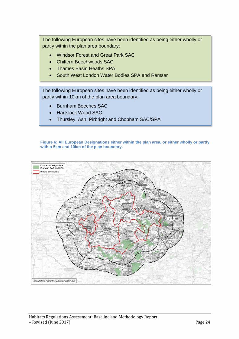
Figure 6: All European Designations either within the plan area, or either wholly or partly within 5km and 10km of the plan boundary.
The following European sites have been identified as being either wholly or
partly within the plan area boundary:
Windsor Forest and Great Park SAC
Chiltern Beechwoods SAC
Thames Basin Heaths SPA
South West London Water Bodies SPA and Ramsar
The following European sites have been identified as being either wholly or
partly within 10km of the plan area boundary:
Burnham Beeches SAC
Hartslock Wood SAC
Thursley, Ash, Pirbright and Chobham SAC/SPA

Habitats Regulations Assessment: Baseline and Methodology Report – Revised (June 2017) Page 25
Figure 7: Designated SAC sites (Special Areas of Conservation) which lie partly or wholly within the plan area, including the 10km buffer
Figure 8: Classified SPA sites (Special Protection Areas) which lie partly or wholly within the plan area including the 10km buffer

Habitats Regulations Assessment: Baseline and Methodology Report – Revised (June 2017) Page 26
Figure 9: Listed Ramsar sites which lie partly or wholly within the plan area including the 10km buffer
4.6 It will be important to identify any relevant hydrological and ecological links to
European sites beyond the suggested 10km buffer, for example:
Sites linked by surface water corridors (e.g. rivers) to land within the
plan area (Figure 10);
Wetland sites outside the plan area which have significant
hydrogeological links to land within the plan area;
Sites outside the plan area which have significant ecological links with
land in the plan area (e.g. land used by migratory birds);
Sites potentially affected by development such as major waste
installations, which may have a very large zone of influence.

Habitats Regulations Assessment: Baseline and Methodology Report – Revised (June 2017) Page 27
Figure 10: Main rivers within the Plan area
Potential European site designations
4.7 Government policy extends protection of European sites to potential SPAs
(pSPA) and candidate SACs (cSAC). Advice from Natural England indicates
there are no plans to designate new terrestrial European sites during the plan
period.

Habitats Regulations Assessment: Baseline and Methodology Report – Revised (June 2017) Page 28
5. Condition and Conservation Status of the European sites
Conservation objectives for the European Sites
5.1 The next step in gathering baseline data is acquiring information regarding
the conservation objectives for each interest feature of the relevant European
sites.
5.2 There is a generic conservation objective to "maintain in favourable
condition" the relevant qualifying features of the European site. Each
individual SAC and SPA has an agreed conservation objective which defines
the target status for each site with specific reference to these interest
features (See Appendix B – ‘Conservation objectives’).
5.3 Conservation objectives must be considered during HRA. Maintaining
favourable status of European sites is a legal requirement under the Habitats
Regulations, and understanding the risks and threats to achieving this is
essential in determining the likelihood of significant effects from the plan.
5.4 Ramsar sites do not have agreed conservation objectives, but in most
instances overlap with SPA site boundaries. In addition all terrestrial Ramsar
sites in England are also notified as Sites of Special Scientific Interest
(SSSIs). It should be noted that Ramsar qualifying features include a range
of habitats and non-bird species common to SAC designations, as well as
bird species and assemblages and their supporting habitats, which are
common to SPAs.
5.5 In the UK, European site conservation objectives are set out with reference
to the interest features of the component SSSIs (see: Appendix C: 'European
sites: SSSI units') following weight of available historic evidence. Currently,
the information on the conservation objectives varies as they are subject to
periodic reassessment by Natural England and may be updated to reflect
new information or knowledge. Where conservation objectives are in draft
form this will be acknowledged, and where no detailed conservation
objectives are available, information from the SSSI citations will be used to
demonstrate the estimated detailed interest features.
Condition of European sites
5.6 The next step in gathering baseline data is the acquisition of information
about the condition and conservation status of the relevant European sites.

Habitats Regulations Assessment: Baseline and Methodology Report – Revised (June 2017) Page 29
The condition status is a description of the state of a ‘site’ feature that
comprises both its condition and the state of factors likely to affect it.
5.7 The condition data gathered can be found in Appendix D: 'European SSSI
Site Conditions' which identifies the varying conditions of the sites, based on
their component Sites of Special Scientific Interest (SSSI) units.. Data has
been taken from Natural England Sites List information9.
5.8 There are only seven SSSI units which are considered to be of an
‘Unfavourable – declining condition’, where it is considered that the special
interest of the SSSI unit is not being conserved and will not reach favourable
condition unless there are changes to site management or external
pressures, with site condition becoming progressively worse.
5.9 Natural England record condition details and provide the reason for adverse
condition relevant to the SSSI unit assessed. Understanding these reasons
is important in determining whether a plan is likely to have a significant effect
or not (see Section 7). Reasons for adverse condition given for the various
habitats types include:
Inappropriate scrub control;
Inappropriate water levels;
Under-grazing;
Invasive freshwater species;
Siltation;
Water pollution - agriculture/run off;
Water pollution – discharge;
Inappropriate dredging (e.g. intertidal habitats destroyed);
Vehicles (e.g. disturbance, accelerating natural erosion);
Decline in extent of open water;
Public access (e.g. too much bare ground);
Drainage (e.g. summer water levels too high);
Forestry management;
Presence of non-native species (garden plants);
Inappropriate weirs dams and other structures.
5.10 As the assessment progresses, information on reasons for unfavourable
condition status of certain SSSI units may be relevant to determining whether
or not the Joint Minerals & Waste Plan is likely to have a significant effect.
9 https://designatedsites.naturalengland.org.uk/SiteSearch.aspx

Habitats Regulations Assessment: Baseline and Methodology Report – Revised (June 2017) Page 30
European site features and sensitivities
5.11 The next step in gathering baseline data is to acquire information about the
interest features and sensitivities of each European site.
5.12 These features will vary between different European sites, but relate to the
reasons for the site's classification (SPAs), designation (SACs) or listing
(Ramsar sites). The attributes of the European sites which contribute to and
define their integrity are identified and described in Appendix A within each
site description.
5.13 Every European site has distinctive characteristics making it vulnerable to a
variety of impact-inducing activities. Due to their location or condition, many
sites also offer opportunities for improvement. The vulnerabilities and
sensitivities of the relevant European sites are shown in Appendix E:
'European site vulnerabilities and sensitivities'.
5.14 Site Improvement Plans (SIPs) have been developed for each Natura 2000
site in England as part of the Improvement Programme for England’s Natura
2000 Sites (IPENS). The plans provide a high level overview of the issues
(both current and predicted) affecting the condition of the Natura 2000
features on the site(s) and outlines the priority measures required to improve
the condition of the features and are based on Natural England’s current
evidence and knowledge.
Further information required
5.15 Further information may be required in order to understand more fully the
vulnerabilities and sensitivities of individual or particular types of European
site. For instance:
Examining the features of interest on a specific site;
Studies looking at particular effects on features of interest (a useful
example would be examining disturbance effects on Annex I bird species).
Habitats Regulations Assessment: Baseline and Methodology Report – Revised (June 2017) Page 31
6. Existing pressures and management issues on the sites
Current European site issues relating to existing development
6.1 Monitoring and assessment of the European sites has identified some broad
issues affecting the sites (in addition to their condition or ‘health’). European
site citation information provided by Natural England highlights where there
are existing impacts/threats to the European sites directly or indirectly,
attributable to pressure from existing development. For example, known
urbanisation effects including recreational pressures.
6.2 This detail would need to be explored at a later stage in the assessment
process, to ascertain whether the plan would exacerbate any existing
problems at the site unit level. Any problems attributable to existing minerals
and waste operations would need to be considered to ascertain any
cumulative impacts.
Current management of European sites
6.3 As part of the HRA, it is necessary to consider all land management plans
currently in existence, to ensure that any actions identified within the Joint
Minerals & Waste Plan do not undermine current management that is
maintaining favourable condition. It will be necessary to look at all land
management plans within Central and Eastern Berkshire (in addition to plans
and projects to be considered in-combination (see paragraph 3.20 onwards -
'In combination effects').

Habitats Regulations Assessment: Baseline and Methodology Report – Revised (June 2017) Page 32
7. Potential effects on European sites
Understanding potential effects
7.1 The Habitats Regulations require that land use plans (and projects) do not
have an adverse affect on the integrity of European sites. This integrity
depends on maintaining key elements of the ecosystem in a favourable
condition.
7.2 Physical changes resulting from minerals and waste development can affect
the underlying interactions between species and the natural environment that
enable an ecosystem to function. The scale and severity of impact on a site
is dependant on the magnitude of effects on key elements of that ecosystem.
Those impacts which affect the integrity of a European site can result from
changes ranging from interactions at an organism level through to population
or even landscape scale, depending on the complexity of interactions
between species or processes that support the underlying ecosystem.
7.3 Adverse or negative impacts are those effects that result in a decreased
functionality of species interaction. A significant effect or impact needs to be
assessed and addressed to ensure that the overall integrity of the European
site is not affected.
Issues potentially affecting European sites
7.4 Considering the potential scope of the Joint Minerals & Waste Plan, it is useful
to identify those impacts that would affect European sites, normally associated
with minerals and waste activities.
Table 7: Description of Hazards from Waste Sites
Hazard Details
Land take Any land take from a European and Ramsar site is likely to have a significant effect on the habitats and/or species for which it was designated. Impacts may also arise through the fragmentation of habitats and/or severance or blocking of movement corridors.
Leachate Contaminants can reach a habitat by leaching through soil and groundwater. Many chemicals can be released in this manner and have a range of impacts depending on their source including: eutrophication, changing the plant communities within a habitat, and reducing the amount of open water for waterfowl. Direct mortality of flora and fauna species and loss of prey species.
Dust Dust is a common hazard from waste sites. It can affect the growth of plants through smothering or changes in chemistry, and can pollute watercourses.

Habitats Regulations Assessment: Baseline and Methodology Report – Revised (June 2017) Page 33
Noise Noise can act as a disturbance to birds and other animal species, potentially disrupting breeding/feeding/roosting or causing species to move out of an area completely. Noise may arise from the operation of machinery and/or extra traffic movements to and from the waste facility.
Lighting Bright lighting of waste facilities during night time operations may cause disturbance to birds, invertebrates and mammals using nearby habitats.
Vermin Waste facilities, especially landfill, can attract a number of vermin species such as rats, crows and gulls. These species can impact on fauna species by predating on bird eggs and out-competing other species.
Traffic Increases in traffic can have a number of potential impacts:
Increasing the amount of disturbance, through increases in noise and vibration.
Increasing the pollution load on the road surface which could eventually run-off and contaminate the habitats surrounding the road.
Reducing air quality increasing sediment run-off from road surfaces.
Impact of Building
The construction of a large or inappropriately sited building adjacent to a designated site can have impacts on bird fauna, by affecting take off and landing routes, and increasing the amount of cover for predatory birds.
Litter Large amounts of litter reaching a habitat can act as a pollutant which could affect flora and fauna species, due to nutrient enrichment or smothering.
Emissions of aerial pollutants
There are many forms of aerial pollution which can have multiple impacts on flora and fauna including:
Production of SOx and NOx which can result in decreases in plant growth.
Increases in air-borne pollutants reaching watercourses, which can result in increases of plant mortality.
Water use Certain waste facilities require the use of large amounts of water. Depending on where this water is obtained from, it can result in the reduction of the natural water table or affect river levels. This could result in the drying out of certain sites, changing vegetation communities, concentrating contaminants and reduce wetland habitats for flora and fauna species.
Water pollution Water pollution can result in a number of impacts on sensitive habitats including reduction in the number of in-stream fauna such as fish and invertebrates; this may have secondary impacts on predator species eutrophication, changing the plant communities within a habitat, and reducing the amount of open water for waterfowl siltation of a watercourse, affecting water quality and flow conveyance (potentially increasing flood risk).
Table 8: Description of Hazards from Minerals Sites
Hazard Details
Land take Any land take from a European and Ramsar site is likely to have a significant effect on the habitats and/or species for which it was designated. Impacts may also arise through the fragmentation of habitats and/or severance or blocking of movement corridors. Note – the sensitive restoration of a mineral extraction site may have long term positive impacts on the environment.
Noise Noise can act as a disturbance to birds and other animal species, potentially disrupting breeding/feeding/roosting or causing species to move out of an area completely. Noise may arise from the operation of extraction machinery and/or extra traffic movements to and from the extraction facility.
Vibration Vibration can act as a disturbance to birds and other animal species (see above). Vibration can be produced through the operation of the extraction machinery and extra traffic movements to and from the extraction facility

Habitats Regulations Assessment: Baseline and Methodology Report – Revised (June 2017) Page 34
Lighting Lighting can cause disturbance to many fauna species. Floodlighting is commonplace in mineral extraction facilities.
Dust Dust is a common hazard from mineral extraction sites. It can impact on the growth of plants, and can potentially pollute watercourses.
Water pollution Water pollution can result in a number of impacts on sensitive habitats including reduction in the number of in stream fauna such as fish and invertebrates; this may have secondary impacts on predator species eutrophication, changing the plant communities within a habitat, and reducing the amount of open water for waterfowl siltation of a watercourse, affecting water quality and flow conveyance (potentially increasing flood risk).
Changes in surface/groundwater hydrology
Changes in the movement of groundwater flows can result in decrease of water reaching certain sites. This could result in the drying out of certain sites, changing vegetation communities, concentrating contaminants and reduce wetland habitats for flora and fauna species. Alternatively, changes in ground water flows can result in saturation or flooding, or changes in water chemistry, which similarly can effect habitat and species composition.
Traffic Increases in traffic can have a number of potential impacts: increasing the amount of disturbance, through increases in noise and vibration increasing the pollution load on the road surface which could eventually run-off and contaminate the habitats surrounding the road. changing air quality increasing sediment run-off from road surfaces.
Further information required
7.5 There are various activities associated with minerals and waste development
which could impact upon European sites. As research and monitoring
progresses, further information may be required not only about the potential for
impacts, but also how these impacts can be appropriately managed by the
application of standards and management measures etc. For waste facilities,
further information will be gathered to complete Table 7.
7.6 A key source of information on issues potentially affecting European sites is
survey work and research that has already been undertaken on the relevant
European sites. It may also be possible to draw upon the findings from studies
elsewhere to inform judgements about relevant European sites (where the
types of habitat or species are the same or similar). Relevant survey and
research information/data will be accessed and drawn upon to inform
assessment decisions
Need for further data or surveys
7.7 Other forms of data may be required at the Appropriate Assessment stage in
order to conclude with certainty that there will not be an adverse effect on a
site's integrity. For example, traffic movement forecast data may be drawn upon
to make judgements about whether there might be a significant increase in
traffic movements along particular routes associated with minerals and waste
development in a particular locality.

Habitats Regulations Assessment: Baseline and Methodology Report – Revised (June 2017) Page 35
APPENDICES
Appendix A: European Sites Fact Files
The following information boxes outline site descriptions and conservation
objectives10.
Sites within the Plan Area
Windsor Forest and Great Park SAC
Location: Windsor and Maidenhead, Bracknell Forest, TQ023784 SAC EU Code: UK0012586 Area: 1680.18ha Windsor Forest and Great Park consists of a large area of continuous dry oak-dominated woodland and parkland and is made up of large population of ancient oak pollards trees. Being partially hollow and decayed, the oaks and beech afford habitats for a number of extremely rare and specialised insects. The predominant habitat is mixed woodland (95%), with areas of dry grasslands and inland water bodies. The soil and geology is a mix of acidic, clay, neutral and sand. The area recently been recognised as having rich fungal assemblages. Atlantic acidophilous beech forests with Ilex and sometimes also Taxus in the shrub layer (Quercion robori-petraeae or Ilici-Fagenion). (Beech forests on acid soils). Old acidophilous oak woods homes the largest number of veteran oaks, Quercus spp. in Britain on sandy plains. (Dry oak-dominated woodland).
It is recognised as international importance for its range of saproxylic invertebrates such as the rare beetle Lacon querceus. In addition the site is thought to support the largest known populations of the Violet Click Beetle, Limoniscus violaceus, in the UK.
Annex I habitats that
are a primary reason for selection of this
site
Annex I habitats
present as a qualifying feature, but not a primary
reason for selection of this site
Annex II species that
are a primary reason for selection of this
site
Annex II species
present as a qualifying feature, but not a primary
reason for site selection
Old acidophilous oak woods with Quercus robur on sandy plains
Atlantic acidophilous beech forests with Ilex and sometimes also Taxus in the shrub layer (Quercion robori-petraeae or Ilici-Fagenion)
Violet click beetle (Limoniscus violaceus)
Not Applicable
10 http://jncc.defra.gov.uk/default.aspx?page=4

Habitats Regulations Assessment: Baseline and Methodology Report – Revised (June 2017) Page 36
Chiltern Beechwoods SAC
Location: Windsor and Maidenhead, SP975134 SAC EU Code: UK0012724 Area: 1285.86ha The Chilterns Beechwoods represent a very extensive tract of ancient semi-natural beech Fagus sylvatica forests in the centre of the habitat’s UK range. The woodland is an important part of a mosaic with species-rich chalk grassland and scrub. The predominant habitat is broad-leaved deciduous woodland (88%), with other areas of dry glassland steppes (8%) and heath, scrub, maquis, garrigue and phygrana (4%). A distinctive feature in the woodland flora is the occurrence of the rare coralroot bittercress Cardamine bulbifera. The soil and geology is a mix of basic, clay, and limestone, nutrient poor, sand and sedimentary. An extensive tract of Asperulo-Fagetum beech forests (Beech forests on neutral to rich soils), and Semi-natural dry grasslands and scrubland facies: on calcareous substrates, Festuco-Brometalia. (Dry grasslands and scrublands on chalk or limestone). An interest feature of this site, but not a primary reason for the designation is the stag beetle, Lacanus cervus.
Annex I habitats that are a primary reason for selection of this
site
Annex I habitats
present as a qualifying feature, but not a primary
reason for selection of this site
Annex II species that are a primary reason for selection of this
site
Annex II species
present as a qualifying feature, but not a primary
reason for site selection
Asperulo-Fagetum
beech forests
Semi-natural dry grasslands and scrubland facies on calcareous substrates (Festuco-Brometalia)
Not Applicable Stag beetle Lucanus cervus

Habitats Regulations Assessment: Baseline and Methodology Report – Revised (June 2017) Page 37
Thames Basin Heaths SPA
Location: Bracknell forest, SU878566 SPA EU Code: UK9012141 Area: 8274.72 ha The Thames Basin Heaths form part of a complex of heathlands in southern England that support important breeding bird populations. Scattered trees and scrub are used for roosting. The open heathland habitats overlie sand and gravel sediments, give rise to sandy or peaty acidic soils, supporting dry health vegetation, wet heath and bogs. The site consists of tracts of heathland, scrub and woodland, once almost continuous, but now fragmented into separate blocks by roads, urban development and farmland. Less open habitats of scrub, acidic woodland and conifer plantations dominate, within which are scattered areas of open heath and mire.
Species: The site supports important breeding populations of a number of birds of lowland heathland. Most namely Nightjar Caprimulgus europaeus (7.8% of UK population) and Woodlark Lullula arborea (9.9% of UK population), both of which nest on the ground, often at the woodland/heathland edge, and Dartford warbler Sylvia undata (27.8% of UK population), which often nests in gorse Ulex sp.
Annex I Habitats Annex I species
Dartford Warbler Sylvia undata, Nightjar Caprimulgus europaeus,
Woodlark Lullula arborea,
South West London Waterbodies SPA / RAMSAR Location: Windsor and Maidenhead, TQ023746 SPA EU Code: UK9012171 Area: 828.14ha The South-West London Water Bodies comprises a series of embanked water supply reservoirs and former gravel pits that support a range of man-made and semi-natural open water habitats. The predominant habitat (70%) is made up of inland water bodies. There are also areas of improved grassland, humid and mesophile grassland and broad-leaved deciduous woodland. The soil and geology is a mix of alluvium, clay, and mud, neutral and sand.
The reservoirs and gravel pits function as important feeding and roosting sites for wintering wildfowl, in particular Gadwall Anas strepera and Shoveler Anas clypeata, both of which occur in numbers of European importance.
Annex I Habitats Annex I species

Habitats Regulations Assessment: Baseline and Methodology Report – Revised (June 2017) Page 38
Gadwall Anas strepera, Shoveler Anas clypeata
Ramsar Criterion 1
Ramsar Criterion 2
Ramsar Criterion 3
Ramsar Criterion 4
Ramsar Criterion 5
Ramsar Criterion 6
Northern Shoveler (Anas clypeata)
Gadwall (Anas strepera strepera)
Sites outside the Plan Area within the 10km buffer
Burnham Beeches SAC Location: SU949855 SAC EU Code: UK0030034 Area: 383.71ha Burnham Beeches occupies an extensive area of the Burnham Plateau where Thames gravels and underlying Reading Beds give rise to acid soils, supporting mature and developing woodland, old coppice, scrub and heath. The predominant habitat is broad-leaved deciduous woodland (90%), with other areas of heath, scrub, maquis and garrigue, phygrana (5%) and coniferous woodland (5%). The SAC represents an example of Atlantic beech forests in central southern England. It is an extensive area of former beech wood-pasture with many old pollards and associated beech Fagus sylvatica and oak Quercus spp. high forest. Surveys have shown that it is one of the richest sites for saproxylic invertebrates in the UK, including 14 Red Data Book species. It also retains nationally important epiphytic communities, including the moss Zygodon forsteri.
Annex I habitats that
are a primary reason for selection of this
site
Annex I habitats
present as a qualifying feature, but not a primary
reason for selection of this site
Annex II species that
are a primary reason for selection of this
site
Annex II species
present as a qualifying feature, but not a primary
reason for site selection

Habitats Regulations Assessment: Baseline and Methodology Report – Revised (June 2017) Page 39
Atlantic acidophilous beech forests with Ilex and sometimes also Taxus in the shrub layer (Quercion robori-petraeae or Ilici-Fagenion)
Not Applicable Not Applicable Not Applicable
Hartslock Wood SAC Location: SU619789 SAC EU Code: UK0030164 Area: 34.16ha
The steep slopes of this site above the River Thames on the chalk of the Chilterns comprise a mosaic of chalk grassland, chalk scrub and broadleaved woodland, and one of the few examples of ancient yew Taxus baccata wood in the Chilterns. The predominant habitat is mixed woodland (87%) with other areas of dry glassland and steppes (13%). The chalk grassland mostly consists of a mosaic of shorter-turf NVC type CG2 Festuca ovina–Avenula pratensis grassland and taller CG3 Bromus erectus grassland. The site supports one of only three UK populations of monkey orchid Orchis simia, a nationally rare Red Data Book species. Recent storms and landslips have resulted in a diverse age-structure for the yew population. Open patches show a rich flora including local species such as southern wood-rush Luzula forsteri, wood barley Hordelymus europaeus and narrow-lipped helleborine Epipactis leptochila.
Annex I habitats that
are a primary reason for selection of this
site
Annex I habitats present as a
qualifying feature, but not a primary
reason for selection of this site
Annex II species that
are a primary reason for selection of this
site
Annex II species present as a
qualifying feature, but not a primary
reason for site selection
Semi-natural dry grasslands and scrubland facies on calcareous substrates (Festuco-Brometalia)
Taxus baccata woods of the British Isles
Not Applicable Not Applicable Not Applicable

Habitats Regulations Assessment: Baseline and Methodology Report – Revised (June 2017) Page 40
Thursley, Ash, Pirbright and Chobham SAC Location: SU914411 SAC/SPA EU Code: UK0012793 Area: 5154.5ha
The heathland is a series of large fragments of previously more continuous areas and is principally dominated by heather – dwarf gorse (Calluna vulgaris – Ulex minor) dry heathland. There are transitions to wet heath and valley mire, scrub, woodland and acid grassland, including types rich in annual plants., The predominant habitat is heath, scrub, maquis and garrigue, phygrana (75%) with other areas of Bogs, Marshes, Water fringed vegetation, Fens (10%), Coniferous woodland (10%) and Inland water bodies (Standing water, Running water) (5%). This habitat supports an important assemblage of animal species, including numerous rare and local invertebrate species The wet heath at Thursley is NVC type M16 Erica tetralix – Sphagnum compactum and contains several rare plants, including great sundew Drosera anglica, bog hair-grass Deschampsia setacea, bog orchid Hammarbya paludosa and brown beak-sedge Rhynchospora fusca. There are transitions to valley bog and dry heath. Thursley Common is an important site for invertebrates, including the nationally rare white-faced darter Leuccorhinia dubia. The site is selected as a key representative of NVC type H2 Calluna vulgaris – Ulex minor dry heathland. There are transitions to wet heath and valley mire, scrub, woodland and acid grassland, including types rich in annual plants. The habitat support an important assemblage of animal species, including numerous rare and local invertebrate species, European nightjar Caprimulgus europaeus, Dartford warbler Sylvia undata, sand lizard Lacerta agilis and smooth snake Coronella austriaca.
Annex I habitats that
are a primary reason for selection of this
site
Annex I habitats
present as a qualifying feature, but not a primary
reason for selection of this site
Annex II species that
are a primary reason for selection of this
site
Annex II species
present as a qualifying feature, but not a primary
reason for site selection
Northern Atlantic wet heaths with Erica tetralix European dry heaths
Depressions on peat substrates of the Rhynchosporion
Not Applicable Not Applicable Not Applicable

Habitats Regulations Assessment: Baseline and Methodology Report – Revised (June 2017) Page 41
Appendix B: Conservation Objectives Table 9: List of European Sites (SAC) and their conservation objectives and key site sensitivities
Name of SAC
EU Qualifying feature (Annex I and/or Annex II)
Conservation Objective Key Site Sensitivities
Burnham Beeches
H9120. Atlantic
acidophilous beech
forests with Ilex
and sometimes
also Taxus in the
shrub layer
(Quercion robori-
petraeae or Ilici-
Fagenion); Beech
forests on acid
soils
Ensure that the integrity of
the site is maintained or
restored as appropriate, and
ensure that the site
contributes to achieving the
Favourable Conservation
Status of its Qualifying
Features, by maintaining or
restoring;
The extent and
distribution of qualifying
natural habitats;
The structure and
function (including typical
species) of qualifying natural
habitats; and
The supporting
processes on which
qualifying natural habitats
rely.
Chiltern Beechwoods
H6210. Semi-
natural dry
grasslands and
scrubland facies:
on calcareous
substrates
(Festuco-
Brometalia); Dry
grasslands and
scrublands on
chalk or limestone
H9130. Asperulo-
Fagetum beech
forests; Beech
Ensure that the integrity of
the site is maintained or
restored as appropriate, and
ensure that the site
contributes to achieving the
Favourable Conservation
Status of its Qualifying
Features, by maintaining or
restoring;
The extent and
distribution of qualifying
natural habitats and habitats
of qualifying species;
The structure and

Habitats Regulations Assessment: Baseline and Methodology Report – Revised (June 2017) Page 42
forests on neutral
to rich soils
S1083. Lucanus
cervus; Stag beetle
function (including typical
species) of qualifying natural
habitats;
The structure and
function of the habitats of
qualifying species;
The supporting
processes on which
qualifying natural habitats
and the habitats of qualifying
species rely;
The populations of
qualifying species; and
The distribution of
qualifying species within the
site.
Hartslock Wood
H6210. Semi-
natural dry
grasslands and
scrubland facies:
on calcareous
substrates
(Festuco-
Brometalia)
(important orchid
sites); Dry
grasslands and
scrublands on
chalk or limestone
(important orchid
sites)*
H91J0. Taxus
baccata woods of
the British Isles;
Yew-dominated
woodland*
*denotes a priority
natural habitat or
species
Ensure that the integrity of
the site is maintained or
restored as appropriate, and
ensure that the site
contributes to achieving the
Favourable Conservation
Status of its Qualifying
Features, by maintaining or
restoring;
The extent and
distribution of the qualifying
natural habitats;
The structure and
function (including typical
species) of the qualifying
natural habitats; and
The supporting
processes on which the
qualifying natural habitats
rely.
Thursley, Ash,
Pirbright and Chobham
H4010. Northern
Atlantic wet heaths
with Erica tetralix;
Wet heathland with
Ensure that the integrity of
the site is maintained or
restored as appropriate, and
ensure that the site
contributes to achieving the

Habitats Regulations Assessment: Baseline and Methodology Report – Revised (June 2017) Page 43
cross-leaved heath
H4030. European
dry heaths
H7150.
Depressions on
peat substrates of
the
Rhynchosporion
Favourable Conservation
Status of its Qualifying
Features, by maintaining or
restoring;
The extent and
distribution of qualifying
natural habitats;
The structure and
function (including typical
species) of qualifying natural
habitats; and
The supporting
processes on which
qualifying natural habitats
rely.
Windsor Forest and Great Park
H9120. Atlantic acidophilous beech forests with Ilex and sometimes also Taxus in the
shrub layer (Quercion robori-petraeae or Ilici-Fagenion); Beech forests on acid soils H9190. Old acidophilous oak woods with Quercus robur on
sandy plains; Dry oak-dominated woodland S1079. Limoniscus violaceus; Violet
click beetle
Ensure that the integrity of the site is maintained or restored as appropriate, and ensure that the site contributes to achieving the Favourable Conservation Status of its Qualifying Features, by maintaining or restoring; The extent and distribution of qualifying natural habitats and habitats of qualifying species;
The structure and function (including typical species) of qualifying natural habitats;
The structure and function of the habitats of qualifying species;
The supporting processes on which qualifying natural habitats and the habitats of qualifying species rely;
The populations of qualifying species; and
The distribution of qualifying species within the site.

Habitats Regulations Assessment: Baseline and Methodology Report – Revised (June 2017) Page 44
Table 10: List of European Sites (SPA) and their conservation objectives and key site sensitivities
Name of SPA
EU Qualifying feature (Annex I)
Conservation Objective Key Site Sensitivities
South West London
Water Bodies
A051 Anas strepera; Gadwall
(Non-breeding) A056 Anas
clypeata; Northern
shoveler (Non-
breeding)
Ensure that the integrity of
the site is maintained or
restored as appropriate, and
ensure that the site
contributes to achieving the
aims of the Wild Birds
Directive, by maintaining or
restoring;
The extent and
distribution of the habitats of
the qualifying features;
The structure and
function of the habitats of the
qualifying features;
The supporting
processes on which the
habitats of the qualifying
features rely;
The population of each of
the qualifying features; and
The distribution of the
qualifying features within the
site.
Thames Basin Heaths
A224 Caprimulgus europaeus; European nightjar (Breeding) A246 Lullula arborea; Woodlark (Breeding) A302 Sylvia undata; Dartford warbler (Breeding)
Ensure that the integrity of
the site is maintained or
restored as appropriate, and
ensure that the site
contributes to achieving the
aims of the Wild Birds
Directive, by maintaining or
restoring;
The extent and
distribution of the habitats of
the qualifying features;
The structure and
function of the habitats of the
qualifying features;
The supporting
processes on which the

Habitats Regulations Assessment: Baseline and Methodology Report – Revised (June 2017) Page 45
habitats of the qualifying
features rely;
The population of each of
the qualifying features; and
The distribution of the
qualifying features within the
site.
Table 11: List of European Sites (Ramsar) and their conservation objectives and key site sensitivities
Name of SPA
EU Qualifying feature
Conservation Objective Key Site Sensitivities
South West London Water Bodies
Criterion 6:
Northern shoveler ,
Anas clypeata
Gadwall , Anas
strepera strepera
Ensure that the integrity of
the site is maintained or
restored as appropriate, and
ensure that the site
contributes to achieving the
aims of the Wild Birds
Directive, by maintaining or
restoring;
The extent and
distribution of the habitats of
the qualifying features;
The structure and
function of the habitats of the
qualifying features;
The supporting
processes on which the
habitats of the qualifying
features rely;
The population of each of
the qualifying features; and
The distribution of the
qualifying features within the
site.
**Above information is taken rom SPA conservation objectives**

Habitats Regulations Assessment: Baseline and Methodology Report – Revised (June 2017) Page 46
Appendix C: European Sites: SSSI units
SSSI units are divisions of SSSIs used to record management and condition details.
Units are the smallest areas for which Natural England gives a condition
assessment. The size of units varies greatly depending on the types of management
and the conservation interest.
Table 12: List of European Sites (SAC) and name of component SSSIs
Name of SAC SSSI Name No, SSSI units and
number within plan area
Burnham Beeches Burnham Beeches 4, 4
Chiltern Beechwoods
Ashridge Commons and Woods*
7, 0
Aston Rowant Woods* 8, 0
Bisham Woods 2, 2
Bradenham Woods, Park Wood and The Coppice *
5, 0
Ellesborough and Kimble Warrens*
4, 0
Hollowhill and Pullingshill Woods
2, 2
Naphill Common 1, 1
Tring Woodlands* 1, 0
Windsor Hill* 2, 0
Hartslock Wood Hartslock 4, 4
Thursley, Ash, Pirbright and Chobham
Ash to Brookwood Heaths 12, 11
Chobham Common 26, 26
Colony Bog and Bagshot Heath
17, 17
Thursley, Hankley and Frensham Commons*
39, 0
Windsor Forest and Great Park
Windsor Forest and Great Park
22, 22
* Within the SAC, SSSIs lay outside the plan buffer zone.
Table 13: List of European Sites (SPA), component SSSI
Name of SPA SSSI Name No, SSSI units (within
plan area)
South West London Water Bodies
Kempton Park Reservoirs 2, 2
Knight & Bessborough Reservoirs
1, 1
Staines Moor 6, 6
Thorpe Park No 1 Gravel Pit
1, 1
Wraysbury & Hythe End Gravel Pits
6, 6
Wraysbury No 1 Gravel Pit 1, 1

Habitats Regulations Assessment: Baseline and Methodology Report – Revised (June 2017) Page 47
Wraysbury Reservoir 1, 1
Thames Basin Heaths
Ash to Brookwood Heaths 12, 10
Bourley and Long Valley 6, 6
Bramshill 4, 4
Broadmoor to Bagshot Woods and Heaths
13, 13
Castle Bottom to Yateley and Hawley Commons
14, 14
Chobham Common 26, 26
Colony Bog and Bagshot Heath
17, 17
Eelmoor Marsh 3, 3
Hazeley Heath 4, 4
Horsell Common* 6, 0
Ockham and Wisley Commons*
9, 0
Sandhurst to Owlsmoor Bogs and Heaths
3, 3
Whitmoor Common* 9, 0
* Within the SPA, SSSIs lay outside the plan buffer zone.
Table 14: List of European Sites (Ramsar) and name of component SSSIs
Name of Ramsar SSSI Name No, SSSI units and
number within plan area
South West London Water bodies
Kempton Park Reservoirs 2, 2
Knight & Bessborough Reservoirs
1, 1
Staines Moor 6, 6
Thorpe Park No 1 Gravel Pit
1, 1
Wraysbury & Hythe End Gravel Pits
6, 6
Wraysbury No 1 Gravel Pit 1, 1
Wraysbury Reservoir 1, 1

Habitats Regulations Assessment: Baseline and Methodology Report – Revised (June 2017) Page 48
Appendix D: European SSSI Site Conditions Table 15: Condition of SSSI units within SAC designations [Data: March 2017] (Only including SSSI units within the buffer)
SSSI Name Unit Name Area (ha)
Total Area
within plan
buffer area
Condition Condition
Threat Risk
Burnham Beeches SAC
Burnham Beeches
Dorney Wood 39.7
383.40
Favourable No identified Condition Threat
Egypt Woods 143.3
Unfavourable – Recovering
No identified Condition Threat
Burnham Beeches 142.5 Favourable
No identified Condition Threat
East Burnham Common 57.9 Favourable
No identified Condition Threat
Chiltern Beechwoods SAC
Bisham Woods
Tall Trees 2.3
86.04
Unfavourable – Recovering
No identified Condition Threat
Quarry/Fultness/ Inky Down Wood
83.8 Favourable No identified Condition Threat
Hollowhill and Pullingshill Woods
Hollowhill Wood 7.7
22.9
Favourable No identified Condition Threat
Pullingshill Wood
15.2 Favourable No identified Condition Threat
Naphill common Naphill Common 61.49 61.49 Favourable
No identified Condition Threat
Hartslock Wood SAC
Hartslock
Bbont 4.83
41.83
Favourable No identified Condition Threat
Hattonhill Shaw 2.59 Favourable No identified Condition Threat
Hartslock Wood 29.4 Favourable No identified Condition Threat

Habitats Regulations Assessment: Baseline and Methodology Report – Revised (June 2017) Page 49
Pauls Grove 4.98 Unfavourable – Recovering
No identified Condition Threat
Thursley, Ash, Pirbright and Chobham SAC
Ash to Brookwood Heaths
Brookwood Heath
9.37
1462.39
Unfavourable – Recovering
Medium
Woking Borough Council Land
16.47 Favourable Medium
Pirbright Common
26.08 Unfavourable – Recovering
Medium
Peat Moor 0.25 Unfavourable – Recovering
Medium
Ash Ranges (7) 247.78 Unfavourable – Recovering
Medium
12 15.3 Unfavourable – Declining
No assessment of Condition Threat undertaken
Ash Ranges (1) 195.88 Favourable Medium
Former units 9, 10 and 13
352.25 Favourable No identified Condition Threat
Former Units 16 & 17
459.18 Unfavourable – Recovering
No identified Condition Threat
Former units 6 & 15
155.07 Favourable
No identified Condition Threat
Chobham Common
Broomhall Heath
13.30
655.73
Favourable High
North End 6.95
Unfavourable – Recovering
High
Little Arm 29.19
Unfavourable – Recovering
High
Ship Hill 11.27 Favourable High
Burma Road (2) 8.18
Unfavourable – Recovering
High
Long Arm 4.08 Favourable
No identified Condition Threat
Ship Hill 25.81
Unfavourable – Recovering
High
Roundabout Car Park Area
17.36 Unfavourable – Recovering
High
Oystershell Hill 52.10
Unfavourable – Recovering
High
Burma Road (1) 1.55
Unfavourable – Recovering
High
Sunningdale Golf Course
97.17 Favourable High
Brick Hill 12.92 Unfavourable High

Habitats Regulations Assessment: Baseline and Methodology Report – Revised (June 2017) Page 50
– Recovering
Rushy Pond (WO)
14.78 Unfavourable – Recovering
High
Rushy Pond 9.98
Unfavourable – Recovering
High
Chickabiddy Hill 35.56
Unfavourable – Recovering
High
Round Pond 5.86 Favourable High
Near Windsor Road
11.44 Unfavourable – Recovering
High
Albury Bottom (1)
28.17 Unfavourable – Recovering
High
Albury Bottom (2)
79.25 Unfavourable – Recovering
High
Glover’s Pond 3.88 Favourable High
Langshot Bog 54.69
Unfavourable – Recovering
High
Albury Bottom (3)
23.84 Unfavourable – Recovering
High
Butts Hill 39.6
Unfavourable – Recovering
High
Gracious Pond 14.20 Favourable
No identified Condition Threat
Old Slade 36.40 Favourable High
Fish Pool 18.08 Favourable High
Colony Bog and Bagshot Heath
Lightwater Country Park
37.46
1130.51
Unfavourable – Recovering
Medium
High Curly 5.33 Unfavourable – Recovering
No identified Condition Threat
Lightwater Bog 2.92 Unfavourable – Declining
High
Folly Bog 25.952 Favourable Medium
Turf Hill 23.46 Unfavourable – Recovering
Medium
Brentmoor Heath
61.74 Favourable Medium
7 5.21 Favourable Medium
8 4.14 Favourable Medium
Chobham Ridges
51.91 Favourable Medium
Colony Bog 634.73 Favourable Medium
West End and Bisley Common
32.77 Unfavourable – Recovering
Medium
Bisley Common 20.86 Unfavourable – Recovering
Medium
Pirbright Common
93.23 Favourable Medium
Pirbright Ranges
81.7 Unfavourable – Recovering
Medium
Sheets Heath 25.26 Unfavourable Medium

Habitats Regulations Assessment: Baseline and Methodology Report – Revised (June 2017) Page 51
– Recovering
Bisley NRA 4.6 Unfavourable – Declining
Medium
MOD Cowshot Common
19.11 Unfavourable – Recovering
Medium
Windsor Forest and Great Park SAC
Windsor Forest and Great Park
Hollidays Plain 134.86
1,778.85
Unfavourable – Recovering
No identified Condition Threat
High Standing Hill
126.73 Unfavourable – Recovering
No identified Condition Threat
Cranbourne Chase
182.16 Unfavourable – Recovering
No identified Condition Threat
Cranbourne Park
75.17 Favourable No identified Condition Threat
South Forest 137.95 Unfavourable – Recovering
No identified Condition Threat
Rosy Bottom 8.66 Favourable No identified Condition Threat
Snow Hill 71.9 Favourable No identified Condition Threat
Wildboar Enclosure
48.05 Favourable No identified Condition Threat
Great Meadow Pond
14.07 Favourable No identified Condition Threat
Frost Farm East 34.8 Unfavourable – Recovering
No identified Condition Threat
Belvedere Wood 66.87 Unfavourable – Recovering
No identified Condition Threat
Flemish 139.05 Favourable No identified Condition Threat
Rangers 76.12 Favourable No identified Condition Threat
Deer Pen West 142.6 Favourable No identified Condition Threat
Deer Pen East 130.34 Favourable No identified Condition Threat
Central 128.65 Favourable No identified Condition

Habitats Regulations Assessment: Baseline and Methodology Report – Revised (June 2017) Page 52
Threat
Sandpit 87.74 Favourable No identified Condition Threat
Manor Hill 55.24 Unfavourable – Recovering
No identified Condition Threat
Norfolk 84.98 Unfavourable – Recovering
No identified Condition Threat
Weedons 15.67 Unfavourable – Recovering
No identified Condition Threat
Frost Farm West
13.05 Unfavourable – Recovering
No identified Condition Threat
Gardens 4.35 Unfavourable – Recovering
No identified Condition Threat
Table 16: Condition of SSSI units within SAC designations represented as percentage of total area [Data: March 2017]
11
SSSI Name Area (ha)
Favourable Unfavourable – Recovering
Unfavourable – No Change
Unfavourable – Declining
Partially Destroyed
Destroyed
Burnham Beeches
383.4 62.63% 37.37% 0.00% 0.00% 0.00% 0.00%
Bisham
Woods 86.04 97.37% 2.63% 0.00% 0.00% 0.00% 0.00%
Hollowhill and Pullingshill
Woods
22.9 100% 0.00% 0.00% 0.00% 0.00% 0.00%
Naphill Common
61.49 100% 0.00% 0.00% 0.00% 0.00% 0.00%
Hartslock 41.83 88.08% 11.92% 0.00% 0.00% 0.00% 0.00%
Ash to Brookwood Heaths
1462.37 48.7% 50.26% 0.00% 1.04% 0.00% 0.00%
Chobham
Common 655.73 31.15% 68.85% 0.00% 0.00% 0.00% 0.00%
Colony Bog and Bagshot Heath
1130.51 77.58% 21.76% 0.00% 0.67% 0.00% 0.00%
Windsor Forest and
Great Park
1778.85 51.84% 48.16% 0.00% 0.00% 0.00% 0.00%
11 only including the SSSI units within the 10km buffer and therefore some calculations/areas have been re-worked to only
include relevant SSSI units

Habitats Regulations Assessment: Baseline and Methodology Report – Revised (June 2017) Page 53
Table 17: Condition of SSSI units within SPA and Ramsar designations [Data: March 2017]12
SSSI Name Unit Name Area (ha)
Total Area
within plan
buffer area
Condition Condition
Threat Risk
South West London Water Bodies SPA and Ramsar
Kempton Park Reservoirs
Kempton Park East Reservoir
20.12
25.3
Unfavourable – Recovering
Medium
Redhouse Reservoir
5.16 Unfavourable – Recovering
Medium
Knight and Bessborough
Reservoirs Whole Site 63.43 63.43 Favourable Medium
Staines Moor
Poyle Meadow 8.73
510.82
Unfavourable - Declining
No assessment of Condition
Threat undertaken
King George VI Reservoir
175.14 Favourable No identified
Condition Threat
Staines Reservoirs
195.96 Favourable No identified
Condition Threat
Shortwood Pond
10.9 Unfavourable – Recovering
Low
Staines Moor 113.32=8 Favourable Low
Moor Lane 6.69 Favourable No identified
Condition Threat
Thorpe Park No 1 Gravel
Pit
Thorpe Park No 1 Gravel Pit
42.53 42.53 Favourable Medium
Wraysbury & Hythe End Gravel Pits
Northern Grass Area
4.98
117.21
Favourable High
Marshy Grassland with woodland scrub
12.03 Favourable High
Fishing Lake 46.74 Favourable High
Silverwings 21.68 Favourable High
Southeast Lake West
18.98 Favourable High
12 Only including SSSI units within the buffer

Habitats Regulations Assessment: Baseline and Methodology Report – Revised (June 2017) Page 54
Southeast Lake East
12.78 Favourable High
Wrasbury No 1 Gravel Pit
Whole Site 57.72 57.72 Favourable High
Wraysbury Reservoir
Whole site 205.23 205.23 Favourable Medium
Thames Basin Heaths
Ash to Brookwood Heaths
** Please See Table (list table above)
Bourley and Long Valley
1 113.75
823.48
Unfavourable – Recovering
Medium
2 364.98 Unfavourable – Recovering
Medium
3 220.82 Unfavourable – Recovering
Medium
4 32.09 Unfavourable – Declining
No identified Condition
Threat
5 7.04 Favourable Medium
Unit 6 84.77 Unfavourable – Recovering
Medium
Bramshill
Bramshill Plantation
278.09
673.27
Unfavourable – Recovering
Medium
Bramshill forest and Warren
Heath 351.38
Unfavourable – Recovering
High
Warren Heath wetland
communities 43.36
Unfavourable – Recovering
High
Old Unit 14 0.41 Unfavourable – No Change
Low
Broadmoor to Bagshot Woods and Heaths
Bbont 9.28
1696.33
Unfavourable – Recovering
Medium
MoD Surrey South East
91.71 Unfavourable – Recovering
Medium
Poors 78.19 Unfavourable – Recovering
Medium
Bagshot-Rapley 282.66 Favourable Medium
Rapley Lakes 7.87 Favourable No identified
Condition Threat
Redoubts 234.31 Favourable Medium

Habitats Regulations Assessment: Baseline and Methodology Report – Revised (June 2017) Page 55
Western Triangle
84.53 Favourable Medium
Crowthorn Woods
503.58 Favourable Medium
Brooadmoor Bottom Valley
Mire 4.01
Unfavourable – Recovering
High
MoD Berks West
149.44 Unfavourable – Recovering
Medium
Wishmoor Bottom Valley
Mire 14.41
Unfavourable – Recovering
Medium
MoD Berks East
155.4 Unfavourable – Recovering
Medium
MoD Survey North West
80.89 Unfavourable – Recovering
Medium
Castle Bottom to Yateley and Hawley Commons
1 101.89
922.74
Unfavourable – Recovering
Medium
2 55.02 Unfavourable – Recovering
Medium
3 30.44 Unfavourable – Recovering
Medium
4 2.05 Unfavourable – Recovering
Medium
5 118 Unfavourable – Recovering
Medium
6 30.72 Unfavourable – Recovering
Medium
7 26.06 Unfavourable -
Declining Medium
8 5.19 Unfavourable – No Change
Low
9 0.12 Unfavourable – No Change
No identified Condition
Threat
10 2.2 Unfavourable – No Change
Medium
11 14.31 Unfavourable – Recovering
Medium
Eversley Common
76.56 Unfavourable – Recovering
Medium
Yateley Heath Wood
246.11 Favourable Medium
Hawley Common
214.01 Unfavourable – Recovering
Medium
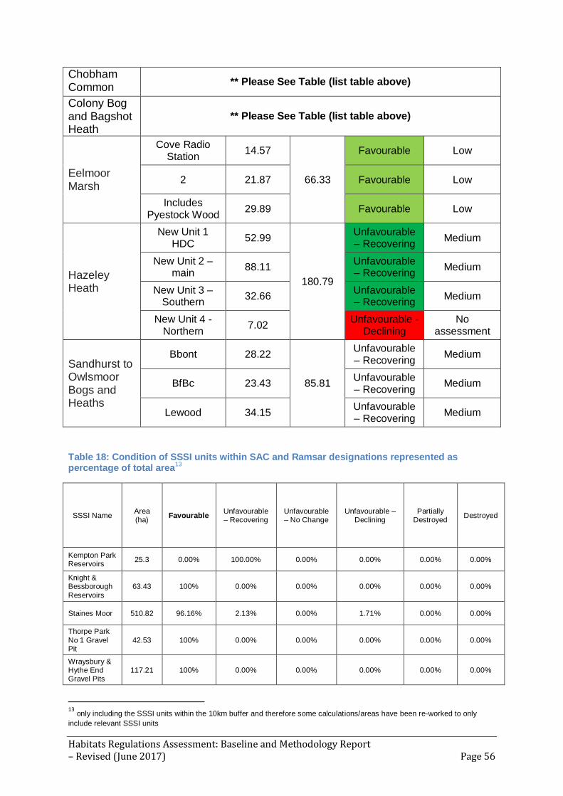
Habitats Regulations Assessment: Baseline and Methodology Report – Revised (June 2017) Page 56
Chobham Common
** Please See Table (list table above)
Colony Bog and Bagshot Heath
** Please See Table (list table above)
Eelmoor Marsh
Cove Radio Station
14.57
66.33
Favourable Low
2 21.87 Favourable Low
Includes Pyestock Wood
29.89 Favourable Low
Hazeley Heath
New Unit 1 HDC
52.99
180.79
Unfavourable – Recovering
Medium
New Unit 2 – main
88.11 Unfavourable – Recovering
Medium
New Unit 3 – Southern
32.66 Unfavourable – Recovering
Medium
New Unit 4 - Northern
7.02 Unfavourable -
Declining No
assessment
Sandhurst to Owlsmoor Bogs and Heaths
Bbont 28.22
85.81
Unfavourable – Recovering
Medium
BfBc 23.43 Unfavourable – Recovering
Medium
Lewood 34.15 Unfavourable – Recovering
Medium
Table 18: Condition of SSSI units within SAC and Ramsar designations represented as percentage of total area
13
SSSI Name Area (ha)
Favourable Unfavourable – Recovering
Unfavourable – No Change
Unfavourable – Declining
Partially Destroyed
Destroyed
Kempton Park Reservoirs
25.3 0.00% 100.00% 0.00% 0.00% 0.00% 0.00%
Knight & Bessborough
Reservoirs
63.43 100% 0.00% 0.00% 0.00% 0.00% 0.00%
Staines Moor 510.82 96.16% 2.13% 0.00% 1.71% 0.00% 0.00%
Thorpe Park
No 1 Gravel Pit
42.53 100% 0.00% 0.00% 0.00% 0.00% 0.00%
Wraysbury & Hythe End Gravel Pits
117.21 100% 0.00% 0.00% 0.00% 0.00% 0.00%
13 only including the SSSI units within the 10km buffer and therefore some calculations/areas have been re-worked to only
include relevant SSSI units

Habitats Regulations Assessment: Baseline and Methodology Report – Revised (June 2017) Page 57
Wraysbury No 1 Gravel Pit
57.72 100% 0.00% 0.00% 0.00% 0.00% 0.00%
Wraysbury Reservoir
205.23 100% 0.00% 0.00% 0.00% 0.00% 0.00%
Ash to Brookwood Heaths
1462.37 48.7% 50.26% 0.00% 1.04% 0.00% 0.00%
Bourley and Long Valley
823.48 0.86% 95.25% 0.00% 3.9% 0.00% 0.00%
Bramshill 673.27 0.00% 99.94% 0.06% 0.00% 0.00% 0.00%
Broadmoor to Bagshot Woods and
Heaths
1696.33 65.61% 34.39% 0.00% 0.00% 0.00% 0.00%
Castle Bottom to Yateley and
Hawley Commons
922.74 26.67% 69.69% 0.81% 2.82% 0.00% 0.00%
Chobham Common 655.73 31.15% 68.85% 0.00% 0.00% 0.00% 0.00%
Colony Bog and Bagshot Heath
1130.51 77.58% 21.76% 0.00% 0.67% 0.00% 0.00%
Eelmoor Marsh 66.34 100% 0.00% 0.00% 0.00% 0.00% 0.00%
Hazeley Heath 180.79 0.00% 96.11% 0.00% 3.89% 0.00% 0.00%
Sandhurst to Owlsmoor
Bogs and Heaths
85.81 0.00% 100% 0.00% 0.00% 0.00% 0.00%

Habitats Regulations Assessment: Baseline and Methodology Report – Revised (June 2017) Page 58
Appendix E: European site vulnerabilities and sensitivities
Table 19 outlines the main pressures and threats ongoing at the identified European Sites14. Table 19: List of European Sites and their main priority pressures and threats
Name Of Site Site Priority Pressure or Threat Further Description
SAC
Burnham Beeches Air Pollution: Risk of atmospheric nitrogen deposition
Public Access/Disturbance
Habitat fragmentation
Deer
Species Decline
Invasive Species
Epiphytic lichen communities are sensitive to nutrient deposition, potential to reduce overall lichen diversity.
Veteran trees are vulnerable to damage as a result of soil compaction.
Development has potential to isolate site from surrounding countryside.
Adverse impact on tree regeneration and flora composition.
Veteran tree numbers decline will impact available habitats for invertebrates.
Oak processionary moth may pose a threat to native invertebrates.
Chiltern Beechwoods Forestry and Woodland Management
Deer
Changes in Species Distributions
Invasive Species
Disease
Public Access/Disturbance
Air Pollution: Impact of atmospheric nitrogen deposition
Restricted regeneration. Threat of climate change.
Browsing by deer prevents/hinders natural regeneration of trees and fauna.
Difficulties in measuring population and habitats.
Grey Squirrels damage trees.
Box Blight has been observed.
Removal of dead wood is an issue impacting on saproxylic invertebrate fauna.
Atmospheric nitrogen deposition exceeds critical load for ecosystem protection.
Hartslock Wood Air Pollution: Risk of Nitrogen deposition exceeds
14 Source: European Site Individual Site Improvement Plans. Natural England:
http://publications.naturalengland.org.uk/category/6149691318206464

Habitats Regulations Assessment: Baseline and Methodology Report – Revised (June 2017) Page 59
atmospheric nitrogen deposition
site-relevant critical load for ecosystem protection. Threat of alteration to mycorrhiza and ground vegetation.
Thursley, Ash, Pirbright and Chobham
Public Access/Disturbance
Undergrazing
Forestry and Woodland Management
Hydrological changes
Inappropriate Scrub Control
Invasive Species
Wildfire/Arson
Air Pollution: Impact of atmospheric nitrogen deposition
Military
Habitat Fragmentation
High levels of recreation use affects distribution and overall numbers of ground-nesting birds.
Lack of grazing has resulted in poor habitat quality and restoration will take a long time.
Maintenance conditions are dependent on rotational felling.
Evidence of damaging impacts due to drainage. Urgent pressure due to changing weather patterns and prolonged doubts.
Current absence of scrub management plans.
Rhododendron and Gaultheria is difficult o control, potential of higher threat to dry heath than wet.
Uncontrolled fires impact reptile populations, inverts and plant diversity resulting in habitat loss for Annex I birds. Also affect to forestry area as well as open heath.
Nitrogen deposits exceed the site-relevant critical load for ecosystem protection. Aerial pollution may be promoting species composition changes.
No integrated management plans are in place, further communication is needed.
Fragmentation has restricted recovery, implications for species which are unable to recolonize. High risk for local extinction of species.
Windsor Forest and Great Park
Forestry and Woodland Management
Loss of ancient/veteran oak trees due to gaps in age classes results in loss of beech forest habitat and reduced habitat for beetle. Difficult to establish

Habitats Regulations Assessment: Baseline and Methodology Report – Revised (June 2017) Page 60
Invasive Species
Disease
Air Pollution: Impact of atmospheric nitrogen deposition
appropriate management measures.
Oak processionary moth is within 20 miles of the site. This could accelerate loss of ancient oak populations. Rhododendron represents a great threat to scrub/grassland/flower rich supporting habitats.
Diseases of native oak are known from local areas.
Nitrogen deposition exceeds site relevant critical loads. Likely sources include Heathrow Airport. Air quality is an issue for old trees, fungi and lichens.
SPA
South West London Waterbodies
Public Access/Disturbance
Changes in Species Distributions
Invasive Species
Natural Changes to Site Conditions
Fisheries: Fish stocking
Inappropriate Weed Control
Potential to disturb protected species; and recreation may reduce suitable habitat (research to support this).
Gadwall numbers are reducing.
Large areas of wetland and terrestrial habitat are infested with Crassula helmsii which are reducing the invertebrate populations which birds feed on. Egyptian geese are showing increases. Potential that geese may compete with protected birds for habitat and food.
Maturation of gravel pits is altering roosting and feeding provision (e.g. bankside vegetation, water chemistry and aquatic biodiversity).
Stocking of fish for recreation angling negatively impacts upon bird populations.
Removal of waterweed impacts upon availability of food for bird species.
Thames Basin Public Access/Disturbance
High levels of recreation use affects distribution and overall numbers of ground-nesting birds.

Habitats Regulations Assessment: Baseline and Methodology Report – Revised (June 2017) Page 61
Undergrazing
Forestry and Woodland Management
Hydrological changes
Inappropriate Scrub Control
Invasive Species
Wildfire/Arson
Air Pollution: Impact of atmospheric nitrogen deposition
Feature Location/Extent/Condition Unknown
Military
Habitat Fragmentation
Lack of grazing has resulted in poor habitat quality and restoration will take a long time.
Maintenance conditions are dependent on rotational felling.
Evidence of damaging impacts due to drainage. Urgent pressure due to changing weather patterns and prolonged doubts.
Current absence of scrub management plans.
Rhododendron and Gaultheria is difficult o control, potential of higher threat to dry heath than wet.
Uncontrolled fires impact reptile populations, inverts and plant diversity resulting in habitat loss for Annex I birds. Also affect to forestry area as well as open heath.
Nitrogen deposits exceed the site-relevant critical load for ecosystem protection. Aerial pollution may be promoting species composition changes.
Gaps in knowledge.
No integrated management plans are in place, further communication is needed.
Fragmentation has restricted recovery, implications for species which are unable to recolonize. High risk for local extinction of species.

Habitats Regulations Assessment: Baseline and Methodology Report – Revised (June 2017) Page 62
Appendix F: Correspondence from Natural England
The following text is Natural England’s response, received 24th April 2017, to a formal
consultation of ‘Version 2 – April 2017’ of this document:
“Many thanks for sending this through. This has been forwarded to me as I am the
lead planning advisor for the authorities involved in this joint minerals and waste
plan.
At this time we don’t have any specific comments to add in relation to the Baseline
Methodology Report; however I have attached an Annex which may be of assistance
when you look to collect your environmental data for the Habitat Regulations
Assessment.
If you have any queries please do not hesitate to get in touch.
Kind Regards,
Amy Steel
Lead Adviser
Thames Team
Sustainable Development
Natural England
2nd Floor, Cromwell House
15 Andover Road
Winchester, SO23 7BT”
The generic Annex attached to the above response is provided on the next page.

Habitats Regulations Assessment: Baseline and Methodology Report – Revised (June 2017) Page 63
Annex 1 - The natural environment: information, issues
and opportunities
Natural environment information sources
The Magic15 website will provide you with much of the nationally held natural environment data for your plan area. The most relevant layers for you to consider are: Agricultural Land Classification, Ancient Woodland, Areas of Outstanding Natural Beauty, Local Nature Reserves, National Parks (England), National Trails, Priority Habitat Inventory, public rights of way (on the Ordnance Survey base map) and Sites of Special Scientific Interest (including their impact risk zones). Local environmental record centres may hold a range of additional information on the natural environment. A list of local record centres is available here16. Priority habitats are those habitats of particular importance for nature conservation, and the list of them can be found here17. Most of these will be mapped either as Sites of Special Scientific Interest, on the Magic website or as Local Wildlife Sites. Your local planning authority should be able to supply you with the locations of Local Wildlife Sites. National Character Areas (NCAs) divide England into 159 distinct natural areas. Each character area is defined by a unique combination of landscape, biodiversity, geodiversity and cultural and economic activity. NCA profiles contain descriptions of the area and statements of environmental opportunity, which may be useful to inform proposals in your plan. NCA information can be found here18. There may also be a local landscape character assessment covering your area. This is a tool to help understand the character and local distinctiveness of the landscape and identify the features that give it a sense of place. It can help to inform, plan and manage change in the area. Your local planning authority should be able to help you access these if you can’t find them online. General mapped information on soil types and Agricultural Land Classification is available (under ’landscape’) on the Magic19 website and also from the LandIS website20, which contains more information about obtaining soil data. Natural environment issues to consider
The National Planning Policy Framework21 sets out national planning policy on protecting and enhancing the natural environment. Planning Practice Guidance22 sets out supporting guidance. Your local planning authority should be able to provide you with further advice on the potential impacts of your plan or order on the natural environment and the need for any environmental assessments.
15 http://magic.defra.gov.uk/ 16 http://www.nbn-nfbr.org.uk/nfbr.php 17http://webarchive.nationalarchives.gov.uk/20140711133551/http:/www.naturalengland.org.uk/ourwork/conservation/biodiversity/protectandmanage/habsandspeciesimportance.aspx 18
https://www.gov.uk/government/publications/national-character-area-profiles-data-for-local-decision-making 19 http://magic.defra.gov.uk/ 20 http://www.landis.org.uk/index.cfm 21
https://www.gov.uk/government/publications/national-planning-policy-framework--2 22 http://planningguidance.planningportal.gov.uk/blog/guidance/natural-environment/

Habitats Regulations Assessment: Baseline and Methodology Report – Revised (June 2017) Page 64
Landscape Your plans or orders may present opportunities to protect and enhance locally valued landscapes. You may want to consider identifying distinctive local landscape features or characteristics such as ponds, woodland or dry stone walls and think about how any new development proposals can respect and enhance local landscape character and distinctiveness. Wildlife habitats Some proposals can have adverse impacts on designated wildlife sites or other priority habitats (listed here23), such as Sites of Special Scientific Interest or Ancient woodland24. If there are likely to be any adverse impacts you’ll need to think about how such impacts can be avoided, mitigated or, as a last resort, compensated for. Priority and protected species You’ll also want to consider whether any proposals might affect priority species (listed here25) or protected species. To help you do this, Natural England has produced advice here26 to help understand the impact of particular developments on protected species. Best and Most Versatile Agricultural Land Soil is a finite resource that fulfils many important functions and services for society. It is a growing medium for food, timber and other crops, a store for carbon and water, a reservoir of biodiversity and a buffer against pollution. If you are proposing development, you should seek to use areas of poorer quality agricultural land in preference to that of a higher quality in line with National Planning Policy Framework para 112. For more information, see our publication Agricultural Land Classification: protecting the best and most versatile agricultural land27. Ancient woodland and veteran trees-link to standing advice You should consider any impacts on ancient woodland and veteran trees in line with paragraph 118 of the NPPF. Natural England maintains the Ancient Woodland Inventory which can help identify ancient woodland. Natural England and the Forest Commission have produced standing advice for planning authorities in relation to ancient woodland and veteran trees. It should be taken into account by planning authorities when determining relevant planning applications. Natural England will only provide bespoke advice on ancient woodland/veteran trees where they form part of a SSSI or in exceptional circumstances. Biodiversity net gain Under section 40 of the Natural Environment and Rural Communities Act 2006 Local Planning Authorities are required to conserve biodiversity. The NPPF section 109 states “the planning system should contribute to and enhance the natural and local environment by minimising impacts on biodiversity and providing net gains in biodiversity wherever possible”.
. Suitable methods for calculating biodiversity net gain can include the Defra biodiversity offsetting metric and the environment bank biodiversity impact calculator.
23http://webarchive.nationalarchives.gov.uk/20140711133551/http:/www.naturalengland.org.uk/ourwork/conservation/biodiversity/protectandmanage/habsandspeciesimportance.aspx 24 https://www.gov.uk/guidance/ancient-woodland-and-veteran-trees-protection-surveys-licences 25http://webarchive.nationalarchives.gov.uk/20140711133551/http:/www.naturalengland.org.uk/ourwork/conservation/biodiversity/protectandmanage/habsandspeciesimportance.aspx 26
https://www.gov.uk/protected-species-and-sites-how-to-review-planning-proposals 27 http://publications.naturalengland.org.uk/publication/35012

Habitats Regulations Assessment: Baseline and Methodology Report – Revised (June 2017) Page 65
Improving your natural environment
Your plan or order can offer exciting opportunities to enhance your local environment. If you are setting out policies on new development or proposing sites for development, you may wish to consider identifying what environmental features you want to be retained or enhanced or new features you would like to see created as part of any new development. Examples might include:
Providing a new footpath through the new development to link into existing rights of way.
Restoring a neglected hedgerow.
Creating a new pond as an attractive feature on the site.
Planting trees characteristic to the local area to make a positive contribution to the local landscape.
Using native plants in landscaping schemes for better nectar and seed sources for bees and birds.
Incorporating swift boxes or bat boxes into the design of new buildings.
Think about how lighting can be best managed to encourage wildlife.
Adding a green roof to new buildings.
You may also want to consider enhancing your local area in other ways, for example by:
Setting out in your plan how you would like to implement elements of a wider Green Infrastructure Strategy (if one exists) in your community.
Assessing needs for accessible greenspace and setting out proposals to address any deficiencies or enhance provision.
Identifying green areas of particular importance for special protection through Local Green Space designation (see Planning Practice Guidance on this 28).
Managing existing (and new) public spaces to be more wildlife friendly (e.g. by sowing wild flower strips in less used parts of parks, changing hedge cutting timings and frequency).
Planting additional street trees.
Identifying any improvements to the existing public right of way network, e.g. cutting back hedges, improving the surface, clearing litter or installing kissing gates) or extending the network to create missing links.
Restoring neglected environmental features (e.g. coppicing a prominent hedge that is in poor condition, or clearing away an eyesore).
28
http://planningguidance.planningportal.gov.uk/blog/guidance/open-space-sports-and-recreation-facilities-public-rights-of-way-and-local-green-space/local-green-space-designation/

Habitats Regulations Assessment: Baseline and Methodology Report – Revised (June 2017) Page 66
Appendix G: Glossary
Appropriate Assessment (AA)
A self-contained step in the wider decision making process of Habitats Regulations
Assessment (HRA), required under Article 6 of the EC Habitats Directive 1992. An
appropriate assessment is only required where the competent authority determines
that the plan or project is likely to have a significant effect on a European site, either
alone of in combination with other plans or projects, and the plan or project is not
directly connected with or necessary to the management of that site.
Biodiversity
The total variety of life on earth, including all genes, species, ecosystems and the
ecological processes of which they are part.
Compensation
Measures taken to make up for the loss of, or permanent damage to, biological
resources through the provision of replacement areas. Any replacement area should
be similar to or, with appropriate management, have the ability to reproduce the
ecological functions and conditions of those biological resources that have been lost
or damaged.
Competent Authority
A competent authority is any Minister, Government Department, public or statutory
undertaker, public body of any description or person holding public office. Used in
the Habitats Regulations to refer to the authority that is responsible for adopting,
authorising or undertaking a plan or project.
Conservation Objectives
A statement of the nature conservation aspirations for a site, expressed in terms of
the favourable condition that is sought for the species and/or habitats for which the
site has been selected to attain.
Conservation Status
Four parameters are considered when assessing the conservation status. For habitat
these are range, area, structure and function (referred to as habitat condition) and
future prospects. For species, the parameters are range, population, habitat (extent
and condition) and future prospects. The Habitats Directive defines when the
conservation status of the habitats and species it lists is to be considered as
favourable.
Cumulative Impacts/effects
Impacts/effects that result from the incremental changes caused by other past,
present or reasonably foreseeable actions together with the plan or project in
question.
Development Plan Document (DPD)
Documents that form part of a statutory development plan such as a District Council
Local Plan.

Habitats Regulations Assessment: Baseline and Methodology Report – Revised (June 2017) Page 67
Favourable Condition
The condition represented by the achievement of the conservation objectives; the
desired condition for a designated habitat or a species on an individual site.
Favourable Conservation Status
The conservation status of habitats and species is ‘favourable’ where all that is
necessary to sustain the habitats and species in the long term is in place.
Habitats Directive
Abbreviated term for European Council Directive 92/43/EEC on the Conservation of
natural habitats and of wild fauna and flora (1992). It is the aim of this Directive to
promote the conservation of certain habitats and species within the European Union
and is implemented in the UK through the Habitats Regulations.
Habitats Regulations
Abbreviated term for The Conservation of Habitats and Species Regulations 2010,
which transposes the Habitats Directive into UK legislation.
Habitats Regulations Assessment (HRA)
As required by the Habitats Directive and the Habitats Regulations, the identification
of any aspects of an emerging plan or project that would have the potential to cause
a likely significant effect on Natura 2000 and Ramsar sites (either in isolation or in
combination with other plans and projects), and to begin to identify appropriate
mitigation strategies where such effects are identified (see also Appropriate
Assessment).
In-Combination Effect
Effects, which may or may not interact with each other, but which could affect the
same receptor or interest feature (i.e. a habitat or species for which a European Site
is designated).
Integrity (of a site)
The coherence of a site’s ecological structure and function across its whole area that
enables it to sustain the habitat, complex of habitats and/or levels of populations of
the species for which it was classified.
Interest Feature
A natural or semi-natural feature for which a European site has been selected. This
includes any Habitats Directive Annex I habitat, any Annex II species and any
population of a bird species for which an SPA has been classified under the Birds
Directive.
Local Development Documents (LDD)
Documents that form part of a statutory development plan (Development Plan
Documents) or which amplify the policies of the statutory development plan
(Supplementary Planning Documents).

Habitats Regulations Assessment: Baseline and Methodology Report – Revised (June 2017) Page 68
Mitigation
Measures taken to avoid or reduce negative impacts. Measures may include locating
the development and its working areas and access routes away from areas of high
ecological interest, or timing works to avoid sensitive periods. See also
compensation (which is separate from mitigation).
Natura 2000
Natura 2000 is an ecological network of protected areas in the territory of the
European Union, comprising Special Areas of Conservation (SAC) and Special
Protection Areas (SPA).
National Planning Policy Framework (NPPF)
Government policy framework that sets out planning policies for England and how
they are expected to be applied. It provides guidance for local planning authorities
and decision-takers, both in preparing development plans and in development
management.
Natural England
A non-departmental public body sponsored by the Department for Environment,
Food and Rural Affairs (Defra), responsible for ensuring that England's natural
environment, including its land, flora and fauna, freshwater and marine
environments, geology and soils, are protected and improved. It also has a
responsibility to help people enjoy, understand and access the natural environment.
NOx
Nitrogen Oxides.
Precautionary Principle
An approach which takes avoiding action based on the possibility of significant
environmental or other damage, even before there is conclusive evidence that the
damage will occur.
Ramsar Site
An internationally important wetland, designated under the Convention on Wetlands
of International Importance especially as Wildfowl Habitat (Ramsar, Iran) 1971 and,
as a matter of government policy, are afforded the same protection as a site
designated under the EU Habitats and Birds Directives.
Scoping
Determination of the extent of an Appropriate Assessment.
Screening
Determination of whether or not an Appropriate Assessment is necessary.
Site of Special Scientific Interest (SSSI)
A site designated by Natural England as an area of special interest by reason of any
of its flora, fauna, geological or physiographical features.
SOx
Sulphur Oxides.

Habitats Regulations Assessment: Baseline and Methodology Report – Revised (June 2017) Page 69
Special Area of Conservation (SAC)
A site designated under the European Commission Directive on the Conservation of
Natural Habitats and of Wild Fauna and Flora and part of the European network of
Natura 2000 sites.
Special Protection Area (SPA)
A site designated under the European Commission Directive on the Conservation of
Wild Birds and part of the European network of Natura 2000 sites.
Sustainability Appraisal (SA)
A systematic process that must be carried out during the preparation of a Local Plan.
Its role is to promote sustainable development by assessing the extent to which the
emerging plan, when judged against reasonable alternatives, will help to achieve
relevant environmental, economic and social objectives. Sustainability appraisal
incorporates the requirements of strategic environmental assessment (SEA).
Strategic Environment Assessment (SEA)
A systematic process to integrate environmental considerations into the preparation
and adoption of plans and programmes with a view to promoting sustainable
development. Often incorporated into Sustainability Appraisal (SA).
Sustainable Development
The use of resources to meet the needs of the present without compromising the
ability of future generations to meet their own needs.

A summary of this document can be made available in large print, in Braille or audio
cassette. Copies in other languages may also be obtained. Please contact
Hampshire Services by email [email protected] or by calling 01962
845785.