Applied Marine Ecology Lab 25 Greengate Road … · Applied Marine Ecology Lab 25 Greengate Road...
17
Applied Marine Ecology Lab 25 Greengate Road Falmouth, MA 02540 Farm Credit East, ACA 240 South Road Enfield, CT 06082 December 21, 2012 Subject: Environmental Site Assessment Report for Point Pleasant Packing, Inc. Point Pleasant Beach, New Jersey Dear Mr. Tom Cosgrove, Vice President, The observations, evaluations and conclusions conveyed in the enclosed Environmental Site Assessment Report dated December 21, 2012 were made under the conditions stated in this letter. No other representations or assertions should be made or implied. The conclusions presented are based on our recent site inspection, communications the facility manager, Mr. Tim DeStories, communications and document reviews from local, state and federal environmental agencies. No subsurface soils or groundwater were tested as part of this investigation. The purpose of this report is to assess the physical and chemical characteristics of the land parcels collectively known as Point Pleasant Packing, Inc. and existing structures with regard to any observed or potential presence in the environment of oil or hazardous materials as defined by NJ/DEP and EPA (Pl-92-500). AMEL’s investigation was designed to conform to ASTM Designation E 1527-94, Standard Practice for Environmental Site Assessments: Phase 1 Environmental Site Assessment Process, Section 7, Records Review, and Section 10, Interviews with Local Government Officials and the Scope of Services outlined by AMEL. In the course of AMEL’s documents reviews and Site inspection, it was discovered there were several historic violations with regard to “sloppy” handling of waste oils and fuel transfer operations. According to the local Fire Enforcement Officer and NJ/DEP, these issues have been resolved. However, AMEL discovered three issues where there is a potential for release to the environment of oil-related materials. I have discussed this with Tim DeStories and included in my report a section recommending immediate actions. The study and report was prepared on behalf, and for your exclusive use, solely for use as an environmental evaluation of the Site. The report and findings shall not, in whole or in part, be disseminated to any other party without your written permission and AMEL. However, AMEL acknowledges and agrees that the Report may be
Transcript of Applied Marine Ecology Lab 25 Greengate Road … · Applied Marine Ecology Lab 25 Greengate Road...

Applied Marine Ecology Lab
25 Greengate Road
Falmouth, MA 02540
Farm Credit East, ACA
240 South Road
Enfield, CT 06082
December 21,
2012
Subject: Environmental Site Assessment Report for Point Pleasant Packing, Inc.
Point Pleasant Beach, New Jersey
Dear Mr. Tom Cosgrove, Vice President,
The observations, evaluations and conclusions conveyed in the enclosed
Environmental Site Assessment Report dated December 21, 2012 were made under the
conditions stated in this letter. No other representations or assertions should be made
or implied. The conclusions presented are based on our recent site inspection,
communications the facility manager, Mr. Tim DeStories, communications and
document reviews from local, state and federal environmental agencies. No subsurface
soils or groundwater were tested as part of this investigation. The purpose of this
report is to assess the physical and chemical characteristics of the land parcels
collectively known as Point Pleasant Packing, Inc. and existing structures with regard
to any observed or potential presence in the environment of oil or hazardous materials
as defined by NJ/DEP and EPA (Pl-92-500). AMEL’s investigation was designed to
conform to ASTM Designation E 1527-94, Standard Practice for Environmental Site
Assessments: Phase 1 Environmental Site Assessment Process, Section 7, Records
Review, and Section 10, Interviews with Local Government Officials and the Scope of
Services outlined by AMEL.
In the course of AMEL’s documents reviews and Site inspection, it was
discovered there were several historic violations with regard to “sloppy” handling of
waste oils and fuel transfer operations. According to the local Fire Enforcement
Officer and NJ/DEP, these issues have been resolved. However, AMEL discovered
three issues where there is a potential for release to the environment of oil-related
materials. I have discussed this with Tim DeStories and included in my report a
section recommending immediate actions.
The study and report was prepared on behalf, and for your exclusive use, solely
for use as an environmental evaluation of the Site. The report and findings shall not, in
whole or in part, be disseminated to any other party without your written permission
and AMEL. However, AMEL acknowledges and agrees that the Report may be

- 2 -
conveyed to the owner, lender, buyer or title insurer associated with this property as
compliance with NJ/DEP, US Coast Guard and EPA for environmental certification.
Results of our investigation indicate no evidence of oil or hazardous materials
subject to NJ/DEP or EPA found on this Site. I trust the Report satisfies your current
requirements. Should you have any questions, please contact me. I look forward to
working with you in the future.
Sincerely,
Joseph M. Forns,
Sr. Scientist
encl/ ESA Report
Invoice
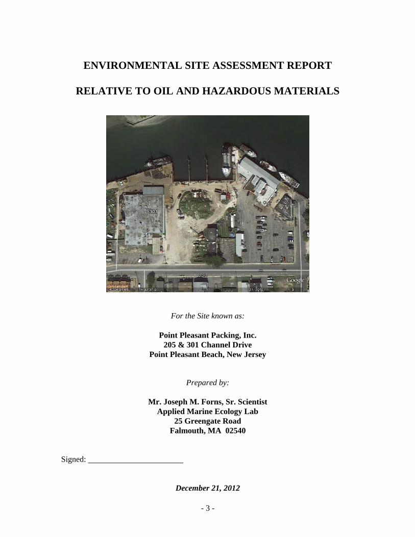
- 3 -
ENVIRONMENTAL SITE ASSESSMENT REPORT
RELATIVE TO OIL AND HAZARDOUS MATERIALS
For the Site known as:
Point Pleasant Packing, Inc.
205 & 301 Channel Drive
Point Pleasant Beach, New Jersey
Prepared by:
Mr. Joseph M. Forns, Sr. Scientist
Applied Marine Ecology Lab
25 Greengate Road
Falmouth, MA 02540
Signed:
December 21, 2012

- 4 -
Report Table of Contents
Item Page
INTRODUCTION 3
ENVIRONMENTAL SETTING 3
Geographic Location and Identification 3
Site Description 4
Identification of Groundwater Category 6
Structures 6
Oil & Hazardous Materials Activities 7
FEDERAL AND STATE ENVIRONMENTAL RECORDS REVIEWS 7
Federal Data Bases 7
NPL; CERCLAS; RCRA TSD; RCRA 7
SPCC Plan 8
STATE ENVIRONMENTAL RECORDS REVIEW 8
New Jersey DEP 8
State Data Bases/State Files 8
Archived Spill Records 8
LOCAL GOVERNMENT AGENCY RECORD REVIEW 9
Assessor’s Office 9
Fire Department 9
Health Department 9
Conservation Commission 9
REPORT CONCLUSIONS 10
Identification of person conducting site inspection and investigation 10
Conclusions of inspection and investigation 10
RECOMMENDATIONS 11
Immediate actions 11
LIMITATIONS 12
REFERENCES 14
LIST OF APPENDICIES 15

- 5 -
INTRODUCTION
Mr. Joseph Forns d/b/a Applied Marine Ecology Lab (AMEL) was contracted by Mr.
Tom Cosgrove of Farm Credit East, ACA in Enfield, CT. to conduct an Environmental
Site Assessment (ESA) for properties known as Point Pleasant Packing, Inc. located at
205 & 301 Channel Drive, Point Pleasant Beach, New Jersey. This investigation was
designed to conform to ASTM Designation E 1527-94, Standard Practice for
Environmental Site Assessments: Phase 1 Environmental Site Assessment Process,
Section 7, Records Review, and Section 10, Interviews with Local Government Officials
and the Scope of Services outlined by AMEL.
AMEL’s investigations consisted of:
1. Federal, State and local database review;
2. Environmental records review at state agencies, regarding the use, storage, and/or
release of oil or hazardous materials at the Site or in the immediate Site vicinity;
3. Assessor’s and Utility records review;
4. Site inspection and evaluation of existing conditions;
5. Data reduction, summarization and report.
The findings of AMEL’s investigations are contained in this report.
AMEL conducted interviews and records review for this Site maintained by the Borough
of Point Pleasant Beach Assessor’s Office, Conservation Commission, Health
Department, Zoning Office, Fire Department and Clerk’s Office; New Jersey Department
of Environmental Protection (NJ/DEP) and US EPA/ CERCLA. No evaluation of
asbestos was undertaken as part of this investigation.
ENVIRONMENTAL SETTING
Geographic Location and Identification
The Site comprises two connected parcels fronting on the north side of Channel Drive
and extending east to Baltimore Ave. These parcels are located on the south side of Wills
Hole Thoroughfare, an intertidal marine waterway extending west from Manasquan Inlet.
The entire premises are within a commercial/industrial area along the north side of
Channel Drive in Point Pleasant Beach, New Jersey. Figure 1 shows an aerial view of the
Site. Figure 2 shows the geographic location of the Site taken from the USGS
Quadrangle. See Appendix A for a detailed description of the individual parcels as
identified on the Point Pleasant Beach Assessor’s Map # 173 Lots# 2 & 2.01. Lot # 2 is a
rectangular parcel occupying 2.5 Acres. Lot# 2.01 is a “Grant Area” permitted for the
bulkhead and vessel services, fueling and dockage along Wills Hole Thoroughfare.

- 6 -
Figure 1. Aerial View of Site at 205 & 301 Channel Drive, Pt. Pleasant Beach, NJ.
Site Description
This Site slopes gently from the north side of Channel Drive to Wills Hole Thoroughfare
at elevation +10 ft. MSL to sea level at the bulkheads. With the exception of minor
landscaping, most of the Site has asphalt paved parking areas and unpaved permeable
surfaces. The paved areas have onsite storm water drainage collection.
The Site is within the 100 year FEMA Flood Zone. According to NJ/GIS, the Site is
comprised of marine deposits extending from the Atlantic Ocean to Wills Hole
Thoroughfare. Soils are comprised of light brown medium to fine marine sands with a
seasonal high water table between 18-36” below existing grade. There are no hydric soils
on this Site and groundwater is assumed to move northerly from Channel Drive to Wills
Hole Thoroughfare. See Appendix B for Site photos and Environmental Site Plan.

- 7 -
USGS Quadrangle Point Pleasant Packing, Inc.
Point Pleasant, N. J. 301 & 205 Channel Drive
Scale: 1:24,000 Point Pleasant Beach, N. J.
Locus: 40º 06’ 07” N
74º 02’ 37” W
Figure 2. Site Location

- 8 -
The immediate neighborhood is completely developed with commercial marinas, office
space and residential properties. While there are no vegetated wetlands on the immediate
premises, the entire north side of the property is located within the Wills Hole
Thoroughfare intertidal waterway extending west from Manasquan Inlet from the
Atlantic Ocean.
Identification of Groundwater Category
The following summary of groundwater information was extracted from information
reviewed at the NJGIS and NJ/DEP regarding the Site property. The Site’s groundwater :
a). is not within a Community Well Head Protection Area;
b). is not within a Potentially Productive Aquifer;
c). is not within the immediate area of a Surface Water Body;
d). is not located five hundred (500) feet or more from a public water distribution pipeline;
e). is not known to be located within five hundred (500) feet of a private water supply well;
There are no community or non-community Well Head Protection Areas (WHPA) within
1 mile of this Site.
Structures
Parcel 173/02, collectively known as 250 & 301 Channel Drive houses five structures,
and two steel and fiberglass bulkheads with piers for vessel dockage. The office building
and former seafood processing area is located at 301 Channel Drive. This is a masonry
structure with slab-on-grade foundation. All floor drainage was formerly collected and
passed to an outside filtration rack and pumped to a fiberglass settlement tank prior to
discharge into the municipal wastewater system. The seafood processing operation is
currently out-of-service and not operating. This building has a natural gas fired steam
boiler that is currently out-of-service but inspected annually and approved. Currently, heat
for this building is electric.
The second structure (main building) is located at the waterfront, identified as 250
Channel Drive and is dedicated to fresh seafood handling activities from the vessels.
There is no seafood processing at this Site. This two-story timber framed and masonry
block structure houses ice production, offices, storage, the primary maintenance
operations and vessel services for the Site. It has a slab-on-grade foundation and was
partially damaged in the recent super storm Sandy. The primary Site activities involve
this structure and immediate area which is used for the transfer of fish products (finfish,
scallops and clams) for truck transport offsite and vessel services including fueling
activities. See Appendix B for Site photos and Site Assessment Plan.
The third structure is a small masonry building used for storage and is located at the
northwest end of the property along Baltimore Ave. at the bulkhead area.
The fourth structure is a two-story former residence for staff and operations personnel. It
appears to be non-operational. Currently it has electric heat but formerly had a natural gas
connection.

- 9 -
The fifth structure is a single story building used for equipment and materials storage. It
has a conventional 275 gal. above ground heating oil storage tank. It is not operational.
However, product was evident in this tank.
All electric utilities for this Site come from overhead wires originating along Channel
Drive. There are eleven pole-mounted electric transformers and all have seals indicating
no PCB’s associated with them. Municipal water and wastewater service this Site. There
are at least two natural gas service lines to this Site but none are currently in service.
Oil & Hazardous Materials Activities
This Site has three above ground fuel storage systems that service fishing vessels. There
is a 17,000 gallon steel above ground (AST) diesel fuel tank and dispenser operation.
There are three, 300-gal. steel AST’s contained within a sea-pack container which
provides lube oils for the vessels. There is an approximately 1,000- gal, steel tank-in-a tub
used for collection and temporary storage of waste oils. All AST’s are permitted,
inspected regularly and have current documentation. There is a US EPA and US Coast
Guard approved Spill Prevention Control & Countermeasures Plan (SPCC) for this Site.
It was last updated during the annual inspection in March, 2012.
FEDERAL AND STATE ENVIRONMENTAL RECORDS REVIEW
Federal databases
Available EPA/CERCLA records regarding releases of oil or hazardous materials were
reviewed on December 3, 2012. No record of a release on the Site parcel or adjacent
parcels was discovered during this review.
NPL
According to the National Priorities List, issued by the EPA, there are no NPL facilities
listed within a one mile radius of the Site.
CERCLIS
Comprehensive Environmental Response, Compensation, and Liability
Information System
The CERCLIS list is a compilation by the EPA, of known or suspected uncontrolled
or abandoned hazardous waste sites, which the EPA has investigated, or is currently
investigating for a release or threatened release of hazardous substances pursuant to
the Comprehensive Environmental Response, Compensation and Liability Act of
1980 (Superfund Act) There are no facilities listed within a 1 mile radius of the Site.
RCRA TSD
According to the RCRA TSD list, issued by the EPA- Region II, there are no RCRA
TSD facilities listed within a ¼ mile radius of the Site which are involved in the
treatment, storage or disposal of hazardous materials.

- 10 -
RCRA
Resource Conservation and Recovery Act
The EPA's RCRA report identifies and tracks hazardous waste from the point of
generation to the point of disposal, in accordance with requirements regarding the
generation, storage, transportation, treatment, or disposal of hazardous waste.
EPA- Region II records indicate there are no RCRA generators located within a ¼
mile radius of this Site.
SPCC Plan
Point Pleasant Packing, Inc., located at 205 Channel Drive has a valid and up-to-date
SPCC plan approved by EPA and US Coast Guard. Their recent site inspection
(March, 2012) indicated no violations. See Appendix C for documentation.
STATE ENVIRONMENTAL RECORDS REVIEW
New Jersey DEP
Available records regarding releases of oil and hazardous materials were reviewed online
and by public document request (OPRA) from NJ/DEP on December 12, 2012.
State databases/ State Files
Records of State registered Underground Storage Tanks (UST) and the local fire
Department indicate there are presently no UST’s located at this Site.
There was an UST at this Site registered to the former owner, Garden State Seafood
that was originally permitted in 1989. This tank was removed April 22, 1994 (Case#
02-5292 USR 000001; Permit #025292) from 250 Channel Drive and the NJ/DEP
status is “no further action required.” There are six registered UST’s in Point Pleasant
Beach. None are within ¼ mile of this Site.
Archived State Spill Records
Available records regarding spills of and contamination by oil and hazardous
materials were reviewed on December 13, 2012. NJ/DEP records indicate two open
case files relating to 205 Channel Drive. NJ/DEP/OPRA records indicate the
following:
PID ID# 018762 Atlantic Capes Fisheries status: SRP-P1
PID ID# 033121 Point Pleasant Packing status: SRP:-P1
Note: Both were related to “sloppy” handling and house keeping of waste oils at
the Site and there are no outstanding issues with these citations.
See Fire Dept, records in Appendix D for additional detail.

- 11 -
LOCAL GOVERNMENT AGENCY RECORD REVIEW
Assessors Office
A review of available files at the Point Pleasant Beach Assessor’s Office concerning the
Site was performed. A copy of the current Assessor’s map and field cards are in
Appendix A.
Fire Department
Communication with the Point Pleasant Beach Fire Department indicated there is a bulk
fuel storage permit for this Site and several historic fuel-related violations and citations at
this Site (205 Channel Drive). See Appendix C & D for additional details.
Health Department
Communications with the Point Pleasant Beach Health Dept. and Ocean County Health
Departments indicate this Site has a valid NJ/PDES Stormwater Discharge Permit
(NJPDES# NJG0171794). See Appendix C for a copy of this document.
Conservation Commission
Communication with the Point Pleasant Conservation Commission indicated the Site
abuts mapped coastal marine waterways but there are no mapped marine wetlands on this
Site. There were no records of any wetland issues with this Site.

- 12 -
REPORT CONCLUSIONS
1. Identification of persons conducting the site inspection and investigation:
Name Address or Affiliation Qualifications
Joseph M. Forns Applied Marine Ecology Lab Sr. Scientist
2. Conclusions of the inspection and investigation:
1. Local, State and Federal environmental records were reviewed pertaining
to this Site.
2. A site inspection of the premises, including evaluation of vessel dockage,
structures, fuel storage, operations and seafood handling systems was
conducted. No subsurface explorations were conducted as part of this
investigation. Presently, there are no underground fuel storage tanks at the
Site.
3. Review of Site history and past property owners was undertaken by
comparison of Borough of Point Pleasant Beach Clerks and Assessor’s
Offices documentation for these premises. The Site owner has been the
same for the past 35 years.
4. Results of AMEL’s review of local, state and federal records indicated
documentation of historic oil or hazardous waste contamination at this Site
subject to NJ/DEP, US EPA and US Coast Guard. Currently, there are no
open enforcement actions related to oil or hazardous materials at this Site.
5. Review of records, AMEL Site investigation and general observations of
immediate abutting properties within ¼ mile of this Site indicate no
evidence of contamination from oil or hazardous materials subject to
NJ/DEP, US EPA or US Coast Guard affecting this Site.
- 13 -
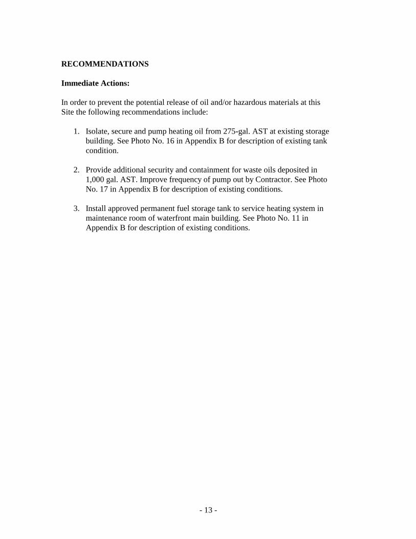
RECOMMENDATIONS
Immediate Actions:
In order to prevent the potential release of oil and/or hazardous materials at this
Site the following recommendations include:
1. Isolate, secure and pump heating oil from 275-gal. AST at existing storage
building. See Photo No. 16 in Appendix B for description of existing tank
condition.
2. Provide additional security and containment for waste oils deposited in
1,000 gal. AST. Improve frequency of pump out by Contractor. See Photo
No. 17 in Appendix B for description of existing conditions.
3. Install approved permanent fuel storage tank to service heating system in
maintenance room of waterfront main building. See Photo No. 11 in
Appendix B for description of existing conditions.

- 14 -
LIMITATIONS
1. AMEL's site evaluation was conducted in accordance with generally
accepted geo-technical and environmental engineering practices and
procedures. Observations and conclusions reported are considered
AMEL's professional opinion relative to the significance of the data
collected and limited extent of investigation. No other warranty is
expressed or implied.
2. AMEL does not and cannot represent that this site contains no
contamination by oil or hazardous subject to NJ/DEP beyond the scope
of observations and investigations stated in this report.
3. The observations, results and conclusions presented in this report are
based solely on the services provided by AMEL to the client as identified
and agreed to by the client in the proposal.
4. In development and preparation of this report, AMEL relied on
information gathered from federal, state and local authorities and other
parties referenced therein. AMEL does not independently verify the
accuracy or completeness of all information reviewed for inclusion in
this report.
5. Observations made in the report relative to site and structure conditions
reflect only those areas accessible and available to AMEL. AMEL
renders no opinion regarding areas not accessible during the site
inspection and makes no representations regarding interior surfaces and
coverings over such surfaces.
6. Unless otherwise indicated in the report, AMEL performed sampling,
testing and analysis only to the extent identified therein. AMEL renders
no opinion relative to the presence at this site of asbestos or any other
chemicals or contaminants not specifically tested for within the scope of
work stated of this limited investigation.
7. This report does not attempt to represent compliance by present or past
owners or operators of this site with federal, state or local laws,
ordinances or regulations, environmental or otherwise. Our professional
liability, by error or omission is limited to the services provided in the
proposal authorized by the client.
8. The purpose of this limited investigation and report is to provide the
client with an assessment of the physical site characteristics with respect
to the presence in the environment of oil or hazardous materials
contamination subject to NJ/DEP.

- 15 -
9. AMEL does not undertake responsibility to report to any federal, state or
local regulatory authority or agency having jurisdiction over existing site
conditions which may present a potential danger to public health, safety
or the environment. The client, by accepting this report agrees to notify
in a timely manner any and all regulatory agencies, as required by law, of
the existence of environmental contamination subject to NJ/DEP and
pollutants defined in the Federal Water Quality Control Act, Federal
Comprehensive Environmental Response, Compensation and Liability
Act (1980) and Resource, Conservation and Recovery Act (1976).
10. AMEL will not disclose information regarding the proposal, AMEL
services or report, except to the client or his authorized designee. This
report and its findings shall not, in whole or in part, be disseminated to
any other party without the written permission of the client and AMEL.
However, AMEL acknowledges and agrees that this report may be
conveyed to a buyer, lender and/or legal counsel, or financial institution
associated with the proximate sale or financing of the site by the client.
11. In the event that other parties obtain information relative to environmental
or hazardous waste issues pertaining to this site which were not
identified or addressed in this report, AMEL reserves the right to review
this information and may modify the conclusions stated in this report.

- 16 -
REFERENCES
Record of Communication
DATE NAME AGENCY
12/03//12 - Ocean County Health Dept. - records request
12/07/12 Janet Mutter Borough of Point Pleasant Beach- Clerk’s
Office- records requests
12/07/12 online US EPA Region 2 Website- RCRA
12/07/12 Amber Stewart NJ/DEP- OPRA documents requests
Published References
NJ/GIS, Topographic Quadrangle, Point Pleasant, New Jersey
SPILL PREVENTION CONTROL AND COUNTERMEASURE PLAN
Point Pleasant Packing, Inc.
205 Channel Drive, Point Pleasant Beach, NJ
(March 21, 2003)

- 17 -
LIST OF APPENDICES
APPENDIX A Assessor’s Map and Property Field Cards
Point Pleasant Beach Assessor’s Map# 173
Point Pleasant Packing, Inc. Parcel# 2 &2.01
APPENDIX B Site Photos of Existing Conditions
Environmental Site Assessment Plan
APPENDIX C Records of Permits & Authorizations
New Jersey DEP- Bulkhead Construction and
dredging Permit (1525-95-0004.1)
New Jersey DEP- Stormwater Discharge Permit
(NJG0171794)
US EPA SPCC Plan & US Coast Guard
approval letter
Waste Management- contractor services
agreement for solid waste removal
Tonk’s Waste Oil Services, LLC- waste oil
disposal agreement
APPENDIX D Site Record of Historic Environmental Violations
1985 Fire Dept. Inspection Report
March 25, 1993 NJ DEP Garden State Seafoods
Case No. 93-3-22-1125-48