Applications ofGeographic Information Systems in...
12
The 4 th Taipei International Conference on Digital Earth, Taiwan. 25-26 May 2006. Applications of Geographic Information Systems in Urban Land Use Planning in Malaysia Narimah Samat Geography Section, School of Humanities Universiti Sains Malaysia, 11800 Penang, MALAYSIA Abstract Over the past forty years Geographic Infonnation Systems (GIS) have been used in many planning applications ranging from daily administrative operations to strategic planning functions such as evaluating socio-economic data in land use allocation tasks. This technology has various analytical functions that can be used in dealing with spatial problems such as urban planning and management issues. It is useful in assisting planners, decision makers and the community to efficiently respond to challenges, plan successful future and improve service delivery. Although GIS has become a common planning tool in many western developed nations, its application in many developing nations is still limited. This paper highlights the applications of GIS in urban land use planning in Malaysia. It will focus on GIS applications by local government authorities; evaluate the role of local universities such as Universiti Sains Malaysia in conducting research on GIS applications; and discuss the future direction of GIS applications in land use planning in Malaysia. Keywords: Geographic Infonnation Systems; Land Use Planning; Malaysia 1. Introduction Urban land use is a dynamic phenomenon, changing with both across space and time. Comprehensive planning is essential in order to ensure that new urban development does not produce negative impact on the society, economy and environment of a region experiencing urban land use changes (Kivell, 1993; Devas and Rakodi, 1993). At present urban planners and city managers in developing nations face rapid urbanization resulted from migration or natural population growth(Choguill, 1994). In 1950, for example, urban population in developing nations was less that 300 million. By 1985, however, it had increased to 1.1 billion. Furtnermore, future projection suggested that people living in major urban centers of developing nations will exceed 4 million by the year 2025 (UNCHS, 1996). This drastic increase of urban population will create pressure to develop land, due to a high demand for residential dwellings and related services (Kivell, 1993, Choguill, 1994). 1
Transcript of Applications ofGeographic Information Systems in...

The 4th Taipei International Conference on Digital Earth, Taiwan. 25-26 May 2006.
Applications of Geographic Information Systems in UrbanLand Use Planning in Malaysia
Narimah SamatGeography Section, School of Humanities
Universiti Sains Malaysia, 11800 Penang, MALAYSIA
AbstractOver the past forty years Geographic Infonnation Systems (GIS) have been used in manyplanning applications ranging from daily administrative operations to strategic planningfunctions such as evaluating socio-economic data in land use allocation tasks. Thistechnology has various analytical functions that can be used in dealing with spatialproblems such as urban planning and management issues. It is useful in assistingplanners, decision makers and the community to efficiently respond to challenges, plansuccessful future and improve service delivery. Although GIS has become a commonplanning tool in many western developed nations, its application in many developingnations is still limited.
This paper highlights the applications of GIS in urban land use planning in Malaysia. Itwill focus on GIS applications by local government authorities; evaluate the role of localuniversities such as Universiti Sains Malaysia in conducting research on GISapplications; and discuss the future direction of GIS applications in land use planning inMalaysia.
Keywords: Geographic Infonnation Systems; Land Use Planning; Malaysia
1. Introduction
Urban land use is a dynamic phenomenon, changing with both across space and time.
Comprehensive planning is essential in order to ensure that new urban development does not
produce negative impact on the society, economy and environment of a region experiencing
urban land use changes (Kivell, 1993; Devas and Rakodi, 1993). At present urban planners
and city managers in developing nations face rapid urbanization resulted from migration or
natural population growth(Choguill, 1994). In 1950, for example, urban population in
developing nations was less that 300 million. By 1985, however, it had increased to 1.1
billion. Furtnermore, future projection suggested that people living in major urban centers of
developing nations will exceed 4 million by the year 2025 (UNCHS, 1996). This drastic
increase of urban population will create pressure to develop land, due to a high demand for
residential dwellings and related services (Kivell, 1993, Choguill, 1994).
1
2. Urbanization in Malaysia
Malaysia, for example, has experienced moderate urban growth when compared with
nations such as Argentina or Brazil (refer to Table 1). Malaysia's urban population in 1975
was 37.6% of her total population of 12.3 million. By the year 2000, Malaysia's population
had increased to 22.3 million and more than 57% of this population lived in urban area
(Salleh, 2000). Although this figure is less alarming when compared with urban growth
experience in Argentina or Mexico, current planning projection suggested that by the year
2020 Malaysia's population will increase to 40.6 million, with 70% of this population living
in urban areas (Department of Statistics, Malaysia 2000). Such an increase in urban
population will result, over time, in a transformation of the physical appearance of many
cities in Malaysia (Ghazali, 1999).
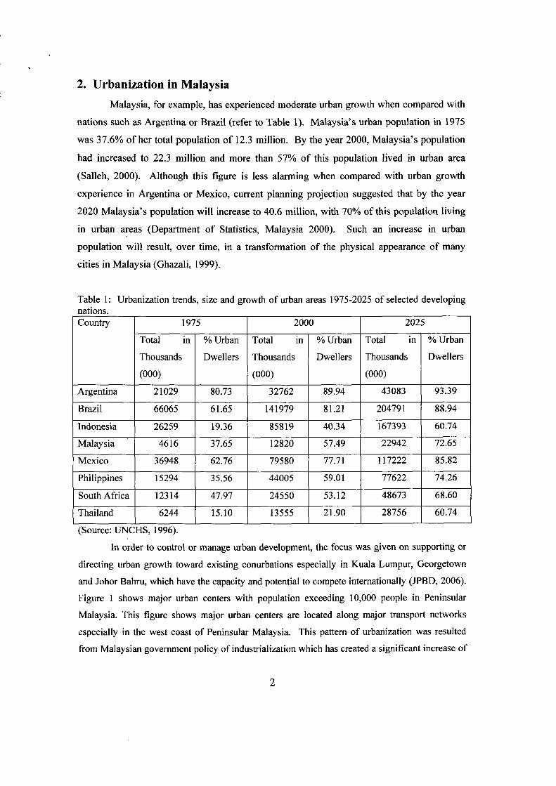
Table I: Urbanization trends, size and growth of urban areas 1975-2025 of selected developingnations.Country 1975 2000 2025
Total in % Urban Total in % Urban Total in % Urban
Thousands Dwellers Thousands Dwellers Thousands Dwellers
(000) (000) (000)
Argentina 21029 80.73 32762 89.94 43083 93.39
Brazil 66065 61.65 141979 81.21 204791 88.94
Indonesia 26259 19.36 85819 40.34 167393 60.74
Malaysia 4616 37.65 12820 57.49 22942 72.65
Mexico 36948 62.76 79580 77.7] ]]7222 85.82
Philippines ]5294 35.56 44005 59.0] 77622 74.26
South Africa ]2314 47.97 24550 53.]2 48673 68.60
Thailand 6244 15.10 13555 21.90 28756 60.74
(Source: UNCHS, 1996).
In order to control or manage urban development, the focus was given on supporting or
directing urban growth toward existing conurbations especially in Kuala Lumpur, Georgetown
and Johor Bahru, which have the capacity and potential to compete internationally (JPBD, 2006).
Figure 1 shows major urban centers with population exceeding 10,000 people in Peninsular
Malaysia. This figure shows major urban centers are located along major transport networks
especially in the west coast of Peninsular Malaysia. This pattern of urbanization was resulted
from Malaysian government policy of industrialization which has created a significant increase of
2

urban population especially in Penang, Selangor and lohor State (Morshidi et aI., 1999).
stRAITSOF.AML4CC:'1
_.-_.. Expressway
Prin,:ipi\1 Highv.i\:Y
-----. Railv.'ay
SOUTHCH1NASEA
P",k,,"NllrnlJi
Fig 1: Major urban areas in Malaysia, town shown in capital letters are towns with populationexceeding 10,000 people. (Source: Ghazali, 1999).
Table 2 shows urbanization level by state from 1970 to 2000. Apart from the Federal Territory
(Kuala Lumpur and Labuan), Penang State and Selangor, for example, become the most
urbanized state with an urbanization level exceeding 80% (Department of Statistics, Malaysia,
2000). This phenomenon is due to the migration of young people from rural to industrial urban
areas (Goh, 1990; Salleh, 2000).
3

- ----- ----- -------~----------
Table 2: Urbanization Level by State, 1970, 1980, 1991, 1995 and 2000.
Urbanization LevelState
1970 1980 1990 1995 2000
Johor 26.3 35.2 48.0 51.8 56.4
Kedah 12.6 14.4 33.1 36.9 42.1
Kelantan 14.1 28.1 33.7 35.7 39.4
Melaka 25.1 23.4 39.4 44.0 49.8
Negeri Sembilan 21.6 32.6 42.5 44.7 47.6
Pahang 19.0 26.1 30.6 31.9 33.7
Perak 27.5 32.2 54.3 60.5 67.8
Pedis - 8.9 26.7 30.4 35.3
Pulau Pinang 51.0 47.5 75.3 80.6 86.1
Sabah 16.9 19.9 32.8 35.2 38.2
Sarawak 15.5 18.0 38.0 43.4 50.5
Selangor 39.5 34.2 75.0 82.6 89.4
Terengganu 27.0 42.9 44.6 45.1 45.7
Federal Territory 100.00 100.00 100.00 100.00 100.00(Kuala Lumpur)
Source: Department of Statistics, Malaysia (1996; 2000).
Significant increase of urban population is the result from Malaysian's government
industrialization policy that started since 1970s. Fig 2 shows urbanization level in Peninsular
Malaysia since 1970 to 2000. In Penang State and Selangor, for example, urban population has
increased from 51 % to 86% and 40% to 89% respectively between 1970 and 2000. Penang State
has become a growth centre of the Northern Region and leader in manufacturing activities in
Malaysia.
Urban population growth has resulted in an increased pressure on land for housing and
related services (Devas and Rakodi, 1993). In 2001, for example, built-up area was
approximately 3.3% or 437,100 hectares of the total area of Peninsular Malaysia. However, this
built-up area is expected to increase to 5.8% or 768,600 hectares in order to cater for urban
population expansion by 2020 (Mohd Atan, 2005). Although this value probably seems to be
small, changes in land use can generate local, regional or global impact on biodiversity, landscape
or living environment. Thus, Local and Federal Authorities at a local or regional level need to be
carefully plan and monitor such growth.
4

Legend
1395 'W()27 - 39.5251·27
e,c,. 141-25.1D()-14.1
a) 1970
Legend:
142.91O()34.2 -42932.2 -34.2
_ ... 23.4-.32.2069-234
b) 1980
Legend·_75-100
1148.7542,5 -48
_331-425CJ267-331
c) 1990 d) 1995
Legend'
=80.6-10051.8-80.6
~44.7-51.8
. :.'.. 357- 447..304 - 357
Legend:.861-100_564-86.1.476-564_39;4-476
e) 2000 CJ337-394
Fig 2: Urbanization level by State inPeninsular. (Source: Dept of Statistics,Malaysia, 2000)
5

3. The Role of Planning Authorities in Planning and Monitoring Urban
Land Use in Malaysia
Urban planning in Malaysia started in 1929, where significant contribution was made by
Charles Reade, a planner who was entrusted to remedy haphazard development of Kuala Lumpur
(Shamsudin, 2005). After that various planning acts were introduced to control and plan urban
development. However, those acts were adopted and used at specific towns in Malaysia (Lee,
Abdullah amd Rahim, 1990). It was not until 1976, when the Town and Country Act were
enacted. This Act imposes a requirement for each Local Authority to be guided by the Structure
Plan, comprehensive long-term planning guideline for entire area under Local Authority
jurisdiction and Local Plan, short-term plan for specific area within Local Authority jurisdiction
(Law of Malaysia, 1998). This planning act was heavily criticized as a replica of the British Town
and Country Planning Act 1968 (England and Wales) (Goh, 1990). It is, however, more
comprehensive in scope and covering not only planning at local (lowest) level but encompassed
Regional and National Spatial Plan (Lee, Abdullah and Rahim, 1990). On the other hand, not
much emphasis was given on the need of Malaysian political and administrative structure. The
reason for the adoption of such plan, however, has not been explored in detailed (Goh, 1990).
Urban planning and monitoring is the responsibility of Town and County Planning
Department (JPBD), which is established to plan, monitor and forecast the use and development
of land for the whole county (JPBD, 2006). JPBD also involves in research and development
(R&D) in order to manage and plan development effectively. This department becomes a think
tank for planning and monitoring urban development in Malaysia. Under this department,
Geotechnical Spatial Analysis Research and Development (GSARD), for example, was
established to accomplish goals of JPBD, which focus primarily on planning and post-planning
practices for various sectors of urban and regional planning processes. This unit is responsible
for evaluating and testing the used of new techniques and approach in planning land use
development. For example, the department is responsible for testing and implementing
Geoinformation Technologies (GIT) for plan generation, plan evaluation, sensitivity analysis,
spatial decision support systems (SDSS) and similar systems and analytical tools having spatial or
geographicaJ dimensions. Thus, GIS and remote sensing have become important planning tools in
managing, updating and mapping land use information (Stillwell et aI., 1999; Samat, 2002;
Yaakup et aI., 2005)
GIS started to play important role in urban planning in Malaysia. In addition,
professional and semi-professional staffs also undertake training in various spatial analysis tools
6

such as multicriteria evaluation techniques, location allocation analysis, land suitability analysis,
transport impact analysis, carrying capacity analysis, hazard/risk analysis, SDSS and remote
sensing. The aim of GSARD is to apply GIS and decision-making software for structure and local
planning studies, relate to plan generation and evaluation purpose. Software currently used
include ArcGIS, ILWIS, and DEFINITE for decision making operation (JPBD, 2006). These
trainings were conducted locally by the department herself, local universities such as Universiti
Sains Malaysia (recently run a course on Using ArcGIS for a group of personnel from Project
Office, Department of Town and Country Planning, Northern Region) or Universiti Teknologi
Malaysia, private agencies, or internationally such as by ITC in the Netherlands.
At present, daily administrative operation such as updating land use data is undertaken
using GIS in most planning department. Strategic planning such as evaluating impact of land use
allocation or scenario planning, has yet to be become a common operation for all planning
departments. Integrated effort in the form of small scale pilot project such as "Application of GIS
for Klang Valley Region - AGISwkl project" and "Penang GIS - PEGIS" developed with the
expertise from local universities are among successful GIS projects in the country.
4. The Role of Local University in Supporting Planning Authority in
Planning and Monitoring Urban Land Use in Malaysia
Although urban planning in Malaysia has started since colonial period prior to 1957,
when this nation gained independent from the British government, Malaysia's planning
regulation has significantly influenced by the British planning regulation. Many planners, for
example, were graduated from the United Kingdom universities (Goh, 1990). Recently,
however, local universities started to play more roles in urban land use planning in Malaysia.
Professional course in Urban and Regional Planning, for example are offered by Universiti
Sains Malaysia (USM), Universiti Teknologi Malaysia (UTM) and International Islamic
University (UIA), while semi-professional course are offered by Polytechnics and UiTM. In
addition Malaya University and National University of Malaysia also offer non-professional
course (Muhamad Ludin, 2005). USM, for example, offers both a Bachelor of Science
Degree in Urban and Regional Planning and a Master of Science in Planning. These
programs provide enough graduates for planning sector in Malaysia. At these instutions,
graduates also acquired GIS skills.
In addition to providing human resource supply for planning agencies in Malaysia,
local universities play vital roles in conducting research on GIS and its applications in urban
7
land use planning (Rainis, 2002). Early GIS applications in urban planning were limited to
the use of functions available within off-the-shelve GIS software packages. These functions
include reclassification operation, map overlay, neighborhood operations and distance and
connectivity operation, which are useful in dealing with urban planning problems such as
undertaking land use allocation operation or suitable site selection (Samat, 2002).
Nowadays, Geographic Infonnation System (GIS) has been used in a) recording and mapping
the distribution of land uses; b) monitoring and updating land use changes; and c) planning
and predicting land use changes (Engelen, et aI., 1999); Stillwell et aI., 1999). In those
applications, GIS provides infonnation and becomes a mechanism by which to implement
planning functions which involve managing daily administrative planning operations,
planning for future growth and evaluating the impact of planning policy on the economy,
society and environment (Couclelis, 1991; Samat, 2002).
A research group called Geoinfonnatic Unit of USM played an important role in
developing spatio-temporal model of urban growth for the Penang State of Malaysia. This
group focused on enhancing spatial analytical capabilities of GIS by coupling this technology
with other models in order to monitor, plan and predict land use changes. Samat (2002), for
example, coupled Cellular Automata Approach and GIS in modeling and evaluating the
impact of various planning scenarios on urban spatial growth. Later, Samat (2005) used GIS,
Agent Based Modelling and Cellular Automata approach in evaluating top-down (the role of
decision makers, planners and political influenced on land use allocation) and bottom-up (the
role of private developers and markets) planning decision on resulted urban spatial growth.
Other applications include Samat (1995), Samat and Rainis (2001), Faris and Rainis (2001)
that coupled GIS and statistical analysis techniques such as discriminant analysis in
predicting residential and commercial land development. Such applications are still at
experimental stages, since most of urban planning applications are conducted on ad-hoc
manner on the basis of a Structure Plan or Local Plan and small numbers of planners or urban
managers (Goh, 1991). In addition, USM also involved in developing GIS application for
Penang State called Penang GIS - PEGIS. This application is among the most successful
GIS application in Malaysia. This GIS centre now plays a major role in providing
infonnation for Penang State Economic Planning Unit.
A research group called GIS and Planning Unit of UTM also is actively involved in
promoting GIS applications in urban planning in Malaysia. This centre, for example, had
involved in various research projects concentrating on building planning support systems
8

such as "Application of GIS for Klang Valley Region - AGISwlk project" (Yaakup et al.,
2005). In this project, a similar approach as undertaken by Klostermann (1999) was adopted,
where a "what-if' model was used. This research centre also is involved in developing a
planning monitoring system for Negeri Sembilan State called GIS9 (Hamdan et aI., 2005).
This system is intended to be used in complement with existing Structure Plan, and act as a
system to monitor manual document of the Structure Plan. The success of this system has yet
to be seen, since it is still at a developmental stage.
5. The Prospects and Challenges of Using GIS in Planning and
Monitoring Urban Land Use in Malaysia
GIS has become a useful planning tool in urban land use planning in Malaysia. As
discussed above local universities play vital role in this matter. This scenario creates two levels
of users, that is local universities as an application developer and Planning Authorities as a user
of such application. Although this is probably a positive sign for GIS development in Malaysia, it
creates a user who is dependent on an application developer to come up with ideas or solution to
urban planning problem. There is a prospect of using GIS in land use planning, however, three
challenges needs to be overcome such as data, personnel, and organization.
Data and its availability in digital format is very important in evaluating urban land use
problem (Verburg and Veldkarnp, 2003). Data has to be updated, come from reliable source and
available at suitable scale. In Malaysia, very few useful digital datasets is available for such
application. , Malaysia's government effort to establish Malaysian Geospatial Data Infrastructure
(MyGDI) hopefully help to solve this problem. The intention was to become data provider for the
nations (Samat, 2005). This agency is hoped to reduce the burden of data input for many GIS
project in the near future. At the state level, Penang GIS (PEGIS) for example, has an established
digital data for Penang State, however, at present the cost of acquiring digital data from this
centre is quite high. Other issue related to data is spatial and temporal scale. Data must be
available at ,different time period and should be transformed to uniform spatial scale. It is quite
problematic to build such datasets since not many agencies keep record of historical land use data
(Sarnat, 2002).
Other issue in using GIS in urban planning is personnel who might be responsible for
using GIS for updating land use map and evaluating strategic plan. At present land use allocation
is conducted in ad-hoc subjective fashion often on the basis of knowledge and experience of a
small group. of senior planners and suggestion made by private consultant (Goh, 1991). On the
9

- -- -------------------------------- --
other hand, management of spatial data using GIS is handled by technical staffs. Thus, in many
cases GIS has only been used in presenting maps or updating land use information (Lee and Tan,
2001). In order to use spatial model in urban planning, planners have to understand and be able
to use GIS and translate planning ideas towards a modeling framework. Other problem that is
related to personnel is transferred of staffs between department at state and national level (Rainis,
2002). Thus, GIS project is difficult to sustain once the responsible staff move to other place.
Finally, other challenge is using land use model is organization. The implementation of
new technology such as in developing a GIS unit requires support from various levels especially
top management within the organization. Continuous support from top management ensures
sufficient funding or enough resources being allocated toward such project. In many
organizations, implementation of GIS failed due to lack of organizational support. In Malaysia,
for example, such problem might be overcome. The adoption of National Spatial Plan, as
mention above, a strategic plan for the whole nation, requires automated planning tool to manage
and monitor land use development. It is imperative that GIS should play more role in managing,
monitoring and planning land use development in Malaysia.
6. Conclusion
Current population projection and related planning policies suggest that Malaysia will
experience rapid urbanization at least until 2020. At present, however, land use allocation is still
being conducted in rather ad-hoc manner, often on the basis of knowledge of a few decision
makers and local planners. Various effort by local universities either working jointly with JPBD
or independently to conduct research or develop planning support systems using GIT. Although
the adoption of GIS at all level of land use planning is quite slow, the development of National
Physical Plan, for example, is seen will spurt the use of GIS in urban land use planning in
Malaysia.
7. References
(1) Choguill, C. L. (1994), Crisis, chaos, crunch? planning for urban growth in the developingworld. Urban Studies, 31 (6), pp.935-945.
(2) Couclelis, H. (1991), Requirements for planning relevant GIS: a spatial perspective. Papers inRegional Science, 70(1), pp.9-19.
10

- - - - - -------------------- - .- .- - -
(3) Devas, N. and Rakodi, C. (1993), The urban challenge. In: Devas, Nand Rakodi, C.eds. Managing Fast Growing Cities: New Approaches to Urban Planning andManagement in the Developing World. Longman Scientific & Technical.
(4) Department of Statistics, Malaysia. (1996), Urbanisation and Urban Growth in MalaysiaDepartment of Statistics Population census monograph's series, 1, Kuala Lumpur, Malaysia.
(5) Department of Statistics, Malaysia. (2000), Laporan kiraan permulaan banci penduduk danperumahan 2000. [Internet]. Available from:<http://www.statistics.gov.mylbahasaJprebanci2k.htm> [Accessed 22 August, 2001.]
(6) Engelen, G., Geertman, S., Smits, P. and Wessels, C. (1999), Dynamic GIS and strategicphysical planning support: a practical application. In: Stillwell, J., Geertman, S. and Openshaw,S. eds. Geographical Information and Planning, London, Springer, pp.87-lll.
(7) Faris, D and Rainis, R (2001) Permodelan Pembangunan Guna Tanah Komersial MenerusiAplikasi GIS: Kajian Kes Seberang Perai Tengah, Pulau Pinang, Jurnal Teknologi: UTM.
(8) Suriati Ghazali (1999), Socio-Economic Changes in the Peri Urban Villages in Penang,Malaysia, Ph.D Thesis, University of Leeds.
(9) Goh Ban Lee (1990), Urban Planning in Malaysia: History, Assumptions and Issues, PetalingJaya: Tempo Publishing.
(10) JPBD (2006), Geotechnical Spatial Analysis Research and Development,[http://www.townplan.gov.my/penyelidikan~sard.php] accessed on 10 April 2006.
(11) Kivell, P. (1993), Land and the City: Pattern and Processes of Urban Change, London,Routledge.
(12) Klosterman, R.E. (1999), The what-if? Collaborative planning support system. EnvironmentAnd Planning B: Planning and Design, 26, pp.393-408.
(13) Law of Malaysia (1998), Laws ofMalaysia Act 172: Town and Country Planning Act 1976,Revision, Malaysia.
(14) Lee Uk Meng, Abdul Mutalip Abdullah and Alip Rahim (1990), Town Planning inMalaysia. Penang, Universiti Sains Malaysia.
(15) Lee Uk Meng and Tan T.S. (2002), GIS for plan making in Penang Island: The roads toonline planning. Online Planning Journal. [Internet}. Available from:<http://www.casa.ucl.ac.uklplanninglarticles611gispenang.pdf> [Accessed: 29 June, 2002].
(16) Mohd Atan, M. J. (2005), Rancangan Fizikal Negara: Pelaksanaan dan Pemantauan, SeniorPlanners Meeting, Department of Urban and Country Planning, Malaysia, 25 - 26 July, Penang,Malaysia.
(17) Mohd Kassim, H., Idris, R., and Yaakup, A (2005), Projek Pembangunan Pangkalan DataSistem Maklumat Geografi Negeri Sembilan, Aplikasi JPBD (GIS9) Senior Planners Meeting,Department of Urban and Country Planning, Malaysia, 25 - 26 July, Penang, Malaysia.
11
(18) Morshidi, Sirat, Abdul Fatah Che Hamat, Abdul Rashid Abdul Aziz, Alip Rahim, HalimSalleh and Usman Hj. Yaakob (1999), Low-Cost Housing in Urban-Industrial Centres ofMalaysia: Issues and Challenges. Penang, Universiti Sains Malaysia.
(19) Muhamad Ludin, Muhamad Nazri (2005), Pendidikan Perancangan Bandar dan Wilayah:Pengalaman UTM, Senior Planners Meeting, Department of Urban and Country Planning,Malaysia, 25 - 26 July, Penang, Malaysia.
(20) Rainis, R. (2002), Sistem Maklumat Geografi di Malaysia: Arah dan Halatuju, inShaharudin Idrus and Abdul Hadi Harman Shah (eds) Round Table Dialogue, Bangi: UniversitiKebangsaan Malaysia, pp. 15-26.
(21) Salleh, G (2000), Urbanisation & Regional Development in Malaysia, Kuala Lumpur,Utusan Publications & Distributors Sdn Bhd.
(22) Samat, N. (1995), Geographic Infonnation System and Remote Sensing in Modelling UrbanDevelopment: A Case Study of Butterworth, Penang State, Malaysia (in Malays), MA Thesis,Malaysia.
(23) Samat, N. (2002), A Geographic Infonnation System and Cellular Automata of UrbanSpatial Model of Urban Development for Penang State, Malaysia, PhD Thesis, Leeds.
(24) Samat, N. (2005), The Integrating GIS and Cellular Automata Model in Evaluating UrbanGrowth: Prospects and Challenges, paper presented at AsiaGIS Conference, 9-10 March, Skudai:Universiti Teknologi Malaysia.
(25) Samat, Nand Rainis, R. (200 I), Integration of GIS and statistical technique to model urbanresidential land use development: a case study of Butterworth, Penang, Malaysian Journal ofRemote Sensing and GIS, Vol 2, 87-97.
(26) Shamsuddin, Kamalruddin (2005), Charles Cromtfton Reade and the Introduction of TownPlanning Service in British Malaya (1921-1929), 8 International Conference of the AsianPlanning Schools Association, II-14th September 2005, Penang: Malaysia.
(27) Stillwell, J, Geertman, S. and Openshaw, S. (1999), Developments in GeographicalInfonnation Systems and Planning. In: Stillwell, J., Geertman, S. and Openshaw, S. eds.Geographical Infonnation and Planning, London, Springer. pp.3-22.
(28) United Nations Centre for Human Settlements (1996), An Urbanizing World: Global ReportOn Human Settlements, Oxford University Press.
(29) Verburg, P.H and Veldkamp, A., (2005), Introduction to the Special Issue on SpatialModelling to Explore Land Use Dynamics, International Journal of Geographic InformationSciences, Vol 19, No 2, pp. 99-102.
(30) Yaakup, A., Johar, F., Abu-Bakar, S.Z., Sulaiman, S., and Baharuddin, M.N. (2005),Integrated Land Use Assessment: The Case of Klang Valley Region, Malaysia, Computer, UrbanPlanning and Urban Management, 29 May - 1 Jun, University College London.
12