APPLICATION REPORT NOVEMBER 2014 - Pays Beaujolais APPLICATION REPORT NOVEMBER 2014 ... Saône...
30
www.pays-beaujolais.com EAUJOLAIS Syndicat mixte du B B APPLICATION REPORT NOVEMBER 2014 ASPIRING GEOPARK BEAUJOLAIS
-
Upload
truongthuy -
Category
Documents
-
view
214 -
download
0
Transcript of APPLICATION REPORT NOVEMBER 2014 - Pays Beaujolais APPLICATION REPORT NOVEMBER 2014 ... Saône...

www.pays-beaujolais.com
EAUJOLAISSyndicat mixte du
BB
APPLICATION REPORT NOVEMBER 2014
ASPIRINGGEOPARK BEAUJOLAIS

Thanks to all those who participated in the elaboration of the present report:
Institutional actors and elected people associated: Communauté de Communes Beaujolais Saône Pierres Dorées, Communauté de Communes de l’Ouest Rhodanien, Communauté de Communes Saône Beaujolais, Communauté de Communes du Haut-Beaujolais, Communauté d’Agglomération Villefranche Beaujolais, Conseil Général du Rhône, Région Rhône-Alpes.
Elected people responsible for the project : Serge Gabardo and Luc Appercel ;
Touristic and economic stakeholders: Destination Beaujolais, O ce de Tourisme du Lac des Sapins, O ce de Tourisme des Pierres Dorées, O ce de Tourisme Beaujolais Vignoble, O ce de Tourisme Villefranche Coeur de Ville, Atouts Beaujolais, Granulats Vicat, Lafarge Ciments, Ninkasi Tarare;
Local stakeholders and associations : itinéraires Paysages et Patrimoine, Les Amis de Bagnols, Les Amis de Salles-Arbuissonnas, Les Amis des Carrières de Glay, AMAC, Espace Pierres Folles, Académie de Villefranche et du Beaujolais, Arts-Civilisations-Patrimoine, Patrimoine et Traditions, Amis Guides en Terre Beaujolaise, Démabule, Elles&Beaujolais, Patrimoine en Haut-Sornin, Château de Montmelas, Hameau Duboeuf, Cadoles et Sens, Le Pays des Brouilly, and all those involved in one way or another.
Members of the Working groups and particularly Ginette Dufour, Jean-Luc Parel, Chanatl Pegaz and Bruno Rousselle, referents for the di erent committees ;
The research rm Territoires et Paysages;
Actors of the civil society supporting the project;
The other French Geoparks for their support and their help in the application project.
We also want to thank people that participated to the writing of the present report for their availability and their skills: Samuel Auray (CAUE du Rhône) for the landscapes, Marylise Bailhache (SMB) for the tourism, Arthur Barabry (SMB) for the agriculture, Guy Blanchet for the climates,
avier de Nee (SMB) for mapping, Jean-Claude Dubois for natural ecosystems, Bruno Ducluzau for hydrogeology, Claire Dupré (SMB) for the economical portrait of the territory, Pierre Gadiolet (Syndicat de rivières) for hydrology, Jean-Luc Parel for environments and vineyards, Chantal Pegaz for the territorial network, Bruno Rousselle (Espace Pierres Folles) for the scienti c and geological part, Michel Senelet (SMB) for mapping, Sophie Todini (SMB) for the graphic conception, Ouda Méchain and Sébastien Vizcaïno (SMB) for their help and support.
Conception: Sophie Todini, artistic director
Traduction: Sophie Justice (Ph.D), Charlotte Besombes.

Table of contents
A.1. Name of the applicant territory
A.2. Surface, physical and social geography
A.2.1. Localization
A.2.2. Area and boundaries
A.2.3. Landscapes entities
A.2.4. Natural and Cultural Environments
A.2.5. Climate
A.2.6. Hydrography
A.2.7. Ecology and biodiversity
A.2.8. Population and demographic evolution
A.2.9. Access
A.3. Organization in charge of the Geopark Beaujolais
A.3.1. The Syndicat Mi te du Beaujolais
A.3.2. How does the organization work?
A.3.3. The territorial charter, the reference document for local development
A.3.4. The Geopark and its network of partners
A.3.5. The Budget
A.4. How to Contact the Beaujolais Syndicat Mi te
A.4.1. Contacts
A.2.4. Website
B.1. De nition of the geographic region
B.2. General geological description of the territory
B.2.1. Introduction
B.2.2. The major geological units of the Beaujolais
B.2.3. The palaeozoic metamorphic and igneous crystalline basement
B.2.4. The marine mesozoic sedimentary cover
B.2.5. The alpine era and the tectonic structuration of todays Beaujolais
B.2.6. The super cial uaternary formations
B.2.7. Prehistoric man in the Beaujolais
B.2.8. Beaujolais’ geology, mineral resources and a human landscape
B.2.9. Beaujolais’ geology and scienti c activity
B.3. Description & list of the geosites
B.3.1. Description of the scienti c geosites by type
1
1
1
1
1
3
5
5
7
9
11
13
14
14
14
17
17
18
19
19
19
19
19
20
20
21
21
25
26
27
27
28
29
30
30
B.3.2. Geosites map
B.4. Details on the interest of the sites
B.4.1. A scienti c interes
B.4.2. A geocultural imprint
B.4.3. Pedagogical and attractive sites with a strong geotouristic potential
C.1. Current and Potential Pressure on the Geosites
C.2. Current Status in Terms of Protection of the Sites
C.3. The Actual Management of the Sites
C.4. The Non-Geological Sites: Description and Integration into the Geopark Framework
D.1. Economic Activities in the Applicant Territory
D.1.1. The General Conte t
D.1.2. Agriculture
D.1.3. Tourism in the Pays Beaujolais
D.1.4. Craft, Industry and Trade
D.2. E isting and Planned Facilities and Infrastructure
D.2.1. E isting Facilities
D.2.2. Planned Facilities
D.3. An Analysis of the Geotourism Potential of the Pays Beaujolais
D.4. Sustainable Development Policies
D.5. Accountability Policies
D.6. Public and Partner Awareness Raising, Implications for Local Stakeholders
E.1. The territory’s Interest in Joining the European Geopark Network
E.1.1. The Development of a New Territorial Strategy
E.1.2. A Project Integrated into the Network
E.2. Reasons for Joining the EGN
32
32
32
33
33
33
33
34
35
35
37
37
37
37
41
44
44
44
46
46
47
47
48
49
49
49
49
50


1The applicant territory is called the Geopark Beaujolais. Its geographic situation, along the French Central Massif Variscan domain and the E ternal Alpine domain, makes it one of the most comple French geological zones where you can we can nd a huge diversity of rocks, processes and geological ages. The territory, whose name is well known in the entire world for its wine production, also has a deeper historic. History gave it its name, captioned by its motto « A tout venant beau jeu ». Beaujeu’ lords, who were the only one to carry that title with Coucy’s and Bourbon’s lords, marked the territory by their presence from 930 to the end of the Middle Age’s; in particular with the wedding of Pierre de Beaujeu and Louis XI’s daughter. She was called by her father “the least crazy woman of France”.
Since Gallo-Roman times, the Beaujolais’ underground wealth has attracted adventurers looking for Lead, for siphon a ueducts, or for the lucrative minerals, in which Jac ues Coeur e celled. Between 1400 and 1500 the only site in France with Vitriol (metal sulphates) deposits was found. This allowed colour ation for clothes, and helped develop the famous Lyon’s fairs. René-Just Haüya famous French mineralogist identi ed some of the Beaujolais’ mineral types, such as « Chessylite ». Alfred Lacroi who was secretary at the French Sciences Academy over 34 years, (author of books on French mineralogy) made many searches in the territory which had built his skills.
A e n t on of t e can ate te to of t e Bea ola s
The applicant Geopark territory, which covers the Pays Beaujolais administrative entity, takes all the north part of the Rhône department. The Pays Beaujolais e tends along the a is of the SaôneRhône Rivers, a natural wealth and transport corridor. It is circled by three big towns: Lyon to the south, Roanne to the west and Mâcon to the north. The north south e tension is imposed by the hydrographic networks and the communication
networks; however, we must not forget the historic importance of the east west transversal network. The applicant Geopark head o ce is located on Villefranche-sur-Saône, its geographic coordinates in Lambert 93 are:
832624,04
6544313,8
1
The territory corresponds to the actual perimeter of the Syndicat Mi te du Beaujolais (SMB), an administrative entity founded in 2009 and which comprises 13
. It covers a 1 3 area, and has a total population of 215 790 inhabitants, spread across areas of contrasting population density. It has an average density of 119 inhabitants per km². Although the Beaujolais is a fragmented territory, the population is mostly concentrated on its borders, particularly on the Val de Saône.In addition to this territory there are some adjoining localities on which there are associated sites integrated into the Geopark. These are located
in the and the , and give a consolidated coherence to the
project : the Oncin uarries, also known as the Glay uarries, located on the southern periphery in the
Rhône department in the town of Saint-Germain Nuelles ; the rhyolitic prismatic jointing of Saint-Victor, located in the Loire department and in the town of Saint-Victor-sur-Rhins ; and the mining site of Romanèche-Thorins, located in the Saône-et-Loire department, in the Bourgogne region.Two centres of urbanisation shape the territory: the Villefranche-sur-Saône agglomeration, and the smaller one of Tarare. Others little towns are situated ne t to communication networks or
1 2
. The urbanised territory, which corresponds almost to 10% of the total area, is particularly situated on the west and south-west borders.
Geopark Boundaries
Landscapes entities

The Saône River corresponds to the border of Beaujolais’ territory and marks a really clear border with the Ain and Dombes’ territories.It has made a huge alluvial valley, which became over the centuries a
between Lyon and the Bourgogne. The Val de Saône is composed of several towns and villages, located far from its ood areas, ne t to the wine growing areas and separated from one another by agricultural and natural areas. Crossed by the A6 highway which is the main route between Lyon-Paris, the former Nationale 6 and the railway, the Beaujolais landscapesalternate between woodland, wet meadows, riverside and alluvial forest, arable cultivation of cereals and vegetables that ourishes on fertile sandy-loam soils.The major riverbed allowed the
in the foreground of the wine areas and the Beaujolais Mountains.
the Beaujolais wine growing area is composed of all the wine hills which dominate the Val de Saône and rise to 600 altitude meters towards the mountains. Crossed by numerous tributaries ofthe Saône, the areas landscapes are made up of slopes, wine growing plateau’s and wooded valleys. There are many villages and hamlets, historically very scattered in the landscape. The vines enjoy well e posed slopes, composed of changeable soils underlain bybetween argilo-calcaire formations in its southern part, and free draining crystalline lands in its northern part. This diveristy in geology and pedology is the origin of these singular wine growing landscapes.
m
nvguc
asge
y clear
d f
memmm over
ne. The villages, growing ral
ch
apeside and etables
1
2
3
4
1
2
3
4
2 3
Rich in its geographic diversity, the Geopark Beaujolais territory is composed of seen from west to east. These are deeply linked to its geomorphology and particularly its geology, from the Val de Saône to the Beaujolais Mountains, peaking at 1000 meters of altitude.
1
2
3
4
grinat
ward
hernpart. This
owing te the ds the
n part, Thi
1
3
24
3
the wine growing landscapes are marked by the presence of an ochre limestone used for building. This one is at the origin of this sector name: .The uite fertile argilo-calcaire soil allows an agricultural diversity, as seen from the poly-culture, which is howeverdominated by vineyards. In the heights of the territory, the vineyards are ne t to the dry, barren limestone landscape and the oak and hornbeam woodlands which determine the border with the Beaujolais Mountains.
lthe limestone gives way to granite and also dry, free draining gravels. The vineyards occupy the major parts of the wine hills and are even denser around the vineyards of the great Beaujolais wines. The valley bottoms are the only areas to present other vegetation, meadows and trees which highlight the watercourses in the middle of these very open wine growing landscapes.The sector, which has bene tted from a long and prosperous past thanks to the vineyard development, has several castles and estates whose grounds with their trees appear like unusual silhouettes in the middle of the vineyards. The uplands of the territory are also composed by barrenlands called «crêts», which are mark the transition to the High Beaujolais forests.
Beyond the ridge that dominates the vineyards, the landscape suddenly changes. The vineyards disappear for
, composed of and . These reliefs, mostly metamorphic, which e tend to the Loire and
the Massif Central, are suitable for sylviculture, particularly coniferous managed forests. The agricultural decline, during the second half of the 20th century has led to the reforestation of the area, speci cally to the predominance growth of , which is of interest for its yield and the uality of its timber. Although the forest is dominated by Douglas r, broad leaved forests do remain, as well as other coniferous plantations of Larch or Spruce. The mountains of Beaujolais are cut by the River Azergues and its huge valley in which there are transport routes to south Beaujolais, in the direction of Lyon. Some historic villages found in the wine growing hills, but the major urban development is linked to the Azergues Valley and its tributaries such as the Turdine.Other small towns have developed at the northern e tremity of the territory, linked to the Loire valley.
1
2
3
4
the presence origin of this
apee b
alsothe wine hills ujolais wines. 1
g
e border
o dry, free e wine hills
1
2
3
4
1
2
3
4
dominates the rds disappear for
d to the Loularly conecond halfpeci callyterest for
leavedns of yare f Lyon.
oire and niferousf of the y to
1
2
3
4
4

2 4
The Beaujolais is characterized by its natural habitats which give it a rich landscape.
is essentially under private management. Wood production, ecological management, landscape conservation and as a leisure destination for the general public are amongst the many activities that we have to reconcile to preserve the forest ecosystem.
is one of the most emblematic and fragile areas of the territory due to its multiple uses: water resource, agriculture, business parks,
uarries, transport by waterway, water sports, etc.
are present in all the areas of the territory as water courses, riverside habitats, peat lands, gravel beds, etc. Those areas are remarkable because of their biological diversity with unusual vegetal and animal species.
can be found in the central part of the territory and contain characteristic and rare species. Dominated by Scotch brooms in addition to Hairy greenweed, Arrowhead woadwa en, Heathers, these places welcome the Woodcock, the Nightjar, the Northern harrier or even the Eurasian eagle-owl. On the limestone hillsides, the dry grasslands shelter di erent varieties of orchids, the hoopoe, the red-backed shrike and an uncommon butter y: the Piedmont ringlet.
Eagle owl
2
its latitude: the 46th parallel is passing through the Beaujolais region, at the heart of the temperate zone its location in Western Europe, at a certain distance from the Atlantic Ocean the presence of a warm sea in the south, the Mediterranean Sea its location between the Eastern Massif Central and the northern part of the Saône-Rhône corridor the di erences of altitude, topography and e posure, which leads to many local climates (topoclimates) the weather processes that changes from one day to the ne t: air masses, the position of high and low
-pressure systems, the path of severe weather patterns.
5
Hoopoe
Woodcock
Peatland
Butter o escues
1
The annual average temperature is about 12°C in the Val de Saône; it decreases with altitude (average of 10°C at an altitude of about 700 meters). The averages decrease more rapidly for the ma imum than for the minimum temperatures.
the Beaujolais can have cold spells (February 1954, February 1956, winter 1962-63, December 1970, January 1985, February 2012). In February 2012 minimum temperatures were reached between -11.8°C in Blacé and -17°C in Les Sauvages and Lamure. During severe winters, the River Saône is partially or completely ice covered (the most recent case dates of February 2012).
heatwaves occur on an irregular basis and are more or less long lasting (summer 1947, July 1952, summer 1976, summer 2003). In August
2003 during the famous heatwave, thermometers reached 36.5°C in Les Sauvages up to 40.2°C in Breuil.
6
ille ranc e s porte ruar
2
Precipitation (rain, snow, drizzle, and hail) occurs as weather fronts arrives from varied directions (the heaviest rains are from the South West, West and North West fronts) or during localised storms especially in summer. The map shows the direct in uence of the relief to the rainfall patterns. The Val de Saône and the low Azergues Valley receive an average of less than 800 mm per year (719 mm in St-Germain s l’Arbresle), the higher parts receive more than 1200 mm. Inter-annual variability is important. The rainfall shows two ma imums, in May and in October November, and a minimum in FebruaryMarch. Some rainfall episodes are remarkable and can cause mud ows and river ooding.
The River Saône had e perienced important oods in 1840 (3650 m3 s), 1856 (3080 m3 s), January 1955 (3250 m3 s), December 1981, December 1982 and January 2004. The rate of ow of the Azergues has reached 384 m3 s in December 2003 and 350 m3 s in November 2008; at this time, the waters of the River Morgon swamped Villefranche causing e tensive damage.
The snow does not play a crucial part in valleys (in Villefranche the ground is snow covered for about ten days per year and the ma imum snow thickness was 26 centimetres in December 1970) ; however it is more and more fre uent as the altitude increases (about 50 days of snow in Les Sauvages at 720 meters and about 70 at the top of the Saint-Rigaud mount at 1000 m). Occasionally it snows on the mountain tops from the beginning of October to June.
Precipitation s ap
3
The Beaujolais region is one of the stormiest regions in France. In terms of annual averages it thirty days of thunder have been recorded. The variability is
uite large; in Villefranche, the range of values are 17 days in 2010 and 45 in 1988; in May of 1990, 14 days of storms were recorded. Storms bring intense downpours and hail-storms that impact the vineyards. Each year many villages are victims of hail-storms.

4
The region e periences periods without rainfall which are damaging to vegetation and crops. The year of 1921 and the summers of 1938, 1976 and 2003 have been amoungst the most intense periods of drought.
5
In the valley of the River Saône there are two dominant winds: the north wind (winter wind) which is the most fre uent and the south wind which is the most violent. In the high mountains the west wind is dominant. From time to time, the Beaujolais region e periences violent storms, for instance in November 1982 and in December 1999 (“Lothar” and “Martin” with winds of 144 km h). In these two cases the forest was greatly damaged.
6
The fog is a characteristic element of the Saône River Valley climate. It is manifest by calm high-pressure conditions in autumn and winter. The top of the fog layer is between 300 and 600 meters; over this layer the sky is blue and the atmosphere is warm and dry (we can see the Alps in the horizon). The annual average number of foggy days in Villefranche is 25. The fog is generally accompanied by heavy pollution. The higher parts of the Beaujolais e perience other types of fog: they are stratus clouds in high-pressure conditions or the lower parts of clouds and climatic disturbances that lead to rainfall.
ists o plains ountains
7
The only sunlight measuring e uipment in Beaujolais is located in Les Sauvages (above 800 meters of altitude); the others in the region are in Lyon-Bron and Mâcon. The annual average is lower in mountain zones but between October and January the sun shines more in mountains because it is above the valleys’ clouds. For the remaing part of the year, and particularly in summer, clouds develop fre uently in the mountains, reducing the presence of the sun.
77
The watersheds of Beaujolais rivers are located in the wine growing part of the Beaujolais, between the Beaujolais Mountains in the west and the Saône Valley in the east. The water system is composed of 7 parallel catchment areas that are located on the right bank of the Saône: the Arlois, the Mauvaise, the Ardières, the Vau onne, the Maverand, the Nizerand and the Morgon. This territory is essentially composed of crystalline rocks as well as volcanic and sedimentary metamorphosed and sandy schists. Within this perimeter are several hydrogeological entities: a uifers in crystalline bedrocks, mostly located in
the north and the west; a uifers of porous formations, located in the Saône
Valley and other valleys downstream; multilayer a uifers; a uifers of carbonate
formations in the Morgon catchment area; and marls, represented in the south.
Landforms and altitude of the Beaujolais Mountains have been inherited from its geological history and from the tectonic movements that have a ected this eastern border of the Massif Central at the end of the Palaeozoic and in the Tertiary. These have determined the orientation of the hydrographical network which has developed in a star shape from the Saint Rigaud Mount (1009 m).
The generally impermeable natures of the geological formations that make up the massif e plain the density of the hydrographic network and the marked absence of underground water resources.
2 6
8
The predominance of the surface runo in uences the marked hydrology of the Beaujolais water courses which are characterized by rapid rises in water level and severely low level discharges.
ooriented North South between Limas and Belmont d’Azergues are without any surface runo . The rainwater lters through the faulted remains of the Mesozoic sedimentary cover that has developed a small karst network.
emerges at the foot of the slopes, at the contact with the underlying marly horizons. They give birth to little water sources locally called « fonts ». The precipitation of carbonates from these mineral-rich waters results in little tufa cascades.The relative hardness of rocks of the Beaujolais Mountains imposes important limits on the course of the rivers; they struggle to erode the substratum so the valleys are narrow and steep-sided. The drop in altitude between the springs and the main valley bottoms are about 300 to 400 meters. The rivers
ow down these slopes over a few kilometres; these steep slopes give them a torrential dynamic.
This undulating, varied topography and living turbulent waters cascading from one block to another through coniferous woods and wet meadows provide a mountain atmosphere, less than 100 kilometres away from the metropolitan area of Lyon.Material eroded from the slopes and carried down the rivers has accumulated over thousands of years in the valley oors and on the alluvial plains of the Rivers Saône and Loire. These accumulations of coarse components (sand, gravel, pebbles) constitute great deposits of alluvial materials that are e ploited in gravel pits for the construction industry.
also constitute important a uifer reservoirs used for drinking water.
, colluvial deposits accumulate in minor topographic depressions on shallow slopes. These form little wetlands where a speci c ora ourishes (Sundews, Cotton Grass, and Marsh Clover).
The natural low mineralization of waters is a property still e ploited by the dyeing industry in the southern part of the mountainous massif. The physico-chemical properties of waters and the physical characteristics of the rivers, in uenced by geology, directly impact the biological process that take place and determine their ecological potential.The streams of the massif are good for trout. However their productivity is limited by the weak summer hydrological conditions and the silting up of river bottoms, e acerbated by land use and soil e ploitation (wine growing and forestry).The particular chemical composition of some rocks, the lodes and metal deposits that are found all over
the massif are the source of a local contamination of water and sediments. These diverse traces of to ic elements (Aluminium, Arsenic, Lead, Manganese...) restrict water use and interfere with the development of a uatic biocenoses.
Groundwaters in Beaujolais
Links etween geolog ri ers in t e ountainous assi
j

The variety of rocks in the Beaujolais region leads to the similar variety in the groundwater. We have observed three di erent types of groundwater ow: in fractured a uifers, in karstic regions and in porous regions. of the North-West are characterised by water circulations in fractured a uifers which lead to natural springs. Some of them are used to supply drinking water: those waters are for most mineralised and good
uality, with certain e ceptions which contain natural arsenic.
contain karst circulation. Water in ltrates in the ground and circulates in caves with underground rivers. The main karstic resurgence is
the Saint Fond’s spring in the municipality of Gleizé. Tracing the underground water has shown that the catchment area e tends up to 5 kilometres to the south of the source. The groundwater in karstic region is low uality. In the east of the River Saône Valley, across a zone that is several kilometres wide, there are alluvial materials that contain an important ground water resource.
Deep groundwater is not known. It can e ist under the alluvial and sedimentary domains. In fractured a uifers, no mineral or thermal spring is currently e ploited.
2 7
The forest covers 33.5 % of the total surface of the applicant territory. The prevalence of coniferous species puts the landscape at risk of becoming enclosed and uniform. A di erentiation has to be made however, between natural regrowth and the increase in managed forests.
regrowth is the conse uence of the abandonment of agricultural land. This phenomenon is a ecting the most inaccessible places, which are often sectors where agriculture has ceased and there is no urbanisation to compensate.
it is the economic development of coniferous managed forests, mostly the Douglas pine, which is occupies a larger surface area. Its spread is assisted by a vigorous self-seeding. The Douglas pine is grown and colonizes set-aside lands, and results in a uniform landscape. Up to 50 meters high and characterised by its fast growth, the Douglas pine (Pseudotsuga menziesii) is the most common timber in the managed forests of the Beaujolais. Located in the Haute Vallée d’Azergues and in the Trambouze Valley,
uniform, dark, giving an impression of large scale landscape, they are mostly located on ridges.The forest environments hold particular species: the Woodcock, the forest Wildcat, the Black Woodpecker, forest bats in Beech forests as the Barbastell and the Greater Mouse-eared Bat, the
Common raven or the Lyn .
The Val de Saône’s landscapes have conserved their original aspect as (Alder, Ash, Oak, Willow) which is developing naturally along riverbanks. The shallow depth and the uality of the water (presence of molluscs and a uatic grass beds) give this place a role as a shelter and a breeding site for sh (Bream, Chub, Bleak, European Bitterling). The ora is also characteristic: the Marsh Ragwort and the Summer Snow ake are some of the remarkable species we can nd here. In ood, the waters of the River Saône spread over
this phenomenon leads to the creation of new environments, which are conducive to the development of a particular ecosystem, whose emblematic ower is the Fritillary which owers in March April.
ouglas orest pines
Woodcock Wild catBlack
Woodpecker
9
ritillar
10
Some others with speci c ecological re uirements are less rare but also remarkable. The Unbranched Bur-reed, the Yellow Water-lily, the Holly-leaved Naiad and the Brittle-leaved Naiad are a uatic plants. One of them has their owers and leaves at the surface of the water, the others are completely immersed. Among birds we can see the Eurasian curlew whose voice announces the Spring, and the Stone-curlew. One can admire the plumage of the Common ing sher and the European Bee-eater, in addition to the Sandpipers, the Stilts and three species of Heron (Night Heron, Purple Heron, Grey Heron) that nest there. The European Beaver is also present, but not permanently installed. Pike is found in the spawning areas, and the Bitterling is present too.
Characterised by a dominant agricultural land use (mostly cattle rearing), the North of the Beaujolais has some of the most wonderful countryside of the Pays Beaujolais. Traversed by the River Grosne, its relief is hilly, creating open landscapes structured by a . The built environment is formed of small hamlets that are incorporated into the countryside. Farms and agricultural buildings are visible in meadows, recalling the importance of agriculture to the conservation and management of open spaces. In northern Beaujolais the pruned hedges and small woodlands act as wind breaks and are made of local species, which distinguish themselves from the uniform forest limits (Douglas pine). In addition to its potential for preserving the local identity, the woodland and hedgerows has ecological (fauna) and hydrological values (struggle against soil erosion and water pollution). This part of the territory has many wetlands which are mostly grazed and are home to speci c ora and fauna.
can be found throughout the entire territory, mostly at the heads of the catchment areas, as waterpoints and permanent streams, wet meadows, peatbogs , gravel pits, reed beds, riverbank woodlands, etc.). These places are remarkable for their biological diversity with rare plant (Fritillary, Violet, Summer Snow ake, Common Meadow-rue) and animal species (Freshwater White-clawed Cray sh, Southern Damsel y, White Throated-dipper, Northern Lapwing, Yellow-Bellied toad, Brown Trout).
The presence of these species is dependent on the wetland uality, which are relatively fragile and depend on the water presence. These environments are threatened with drying-out linked to the agricultural practices (drainage), back lling or the creation of water reservoirs, and also by a lack of maintenance (development of scrub). Poor sh management, the invasion of Japanese knotweed and the e ect of coniferous plantations near the riversides can also threaten these fragile environments.
Some wetland environments have been restored under river management contracts which cover the entire territory.
of the Haut Beaujolais are home to Wolf’s-Bane, with the only site in the Rhone Department (at the top of the Saint-Rigaud Mount) with the Martagon Lily and the Elder owered-Orchid.
The natural heritage has a major importance on the territory, which works on to preserve and promote it through many projects, such as the Natural Heritage Guide of the Beaujolais. This project, implemented by the
, is for the general public.
edicn e Bee eater
Blue da sel Dipper
Elder err orc id onks ood
W ite clawed cra s

The territory of the aspiring Geopark is not immune to the national trends: rural areas close to urban areas which had e perienced a rural e odus in the 1950’s and 1960’s are nowadays subject to a new demographic growth.
The favourable position of peri-urban areas makes them attractive territories, especially for residential use. In general, population is concentrated at the peripheries of the territory. The southeast is in direct contact with the Lyon metropolitan area and has a
strong growing population and a positive migratory balance. Thus, the part of the population living in the predominantly urban area has risen from 61 to 70% between 1990 and 1999. However, the territory presents a dual character: it is youthful in certain sectors and is yet characterized by a phenomenon of a growing aging population (inversion of the demographic pyramid). With a higher rate of young population growth in the east, the west and more particularly the north-west has an older population.
2 8
1990 1999 1999
172 680 184 419 5 645 847
3,2% 3,3%
111 119 129
61,4% 70,3% 86,1%
20 28,1% 26,8% 25,3%
60 20,0% 21,0% 20,0%
1,41 1,28 1,26
Since 1975 there has been steady demographic growth, slightly above 0.7% per year. Thus, the territory combines a slight natural population growth and with the contribution of migration, the
population has increased from 34% between 1962 and 2002. This is almost as much as seen in the reference zone (+36%) but lower than in the Rhône-Alpes Region (+44%).
11
otre Da e des arais ille ranc e sur a neit o nse
12
11 200 - 43 600
3 500 - 11 200
1 600 - 3 500
900 - 1 600
400 - 900
ap o population densit in t e applicant Geopark
erage annual e olution since o t e unicipalities o less
t an in a itants
Urban space, rural space ser ice centres
t

The geographic situation of the applicant candidate is a real asset. Located along the a is of the River Saône, it is crossed by many communication routes: roads, railways, commercial transport by boat and the motorway between Marseille Paris. To travel from east to west between the Saône and Loire Departments we can see many routes: national road n°7 or the road linking Beaujeu to Roanne through the Echarmeau pass which follows the course of the ancient “metal road”. Today’s circulation network is based on Roman roads whose many remnants are found throughout the territory: among the most famous are the Roman roads of Madore, Avenas and Anse which linked Lugdunum (Lyon) to Matisco (Mâcon). The Beaujolais province can also be reached by plane and is in the pro imity of an international airport (Lyon Saint E upéry), there are also numerous railway stations across the territory.
The pro imity to the Lyon metropolitan area and the location of the territory in the middle of a dynamic region, are also essential assets for the ease of its discovery and enjoyment. The universities Claude Bernard Lyon 1, Louis Lumière Lyon 2 and Jean Moulin Lyon 3, the Ecole Normale Supérieure de Lyon, and the Ecole des Mines de Saint-Etienne have study programs and research in the Earth Sciences. Furthermore, important studies have been completed by some of France’s “Grand Ecoles”, such
as the planning of the Mont Brouilly by the Pays des Brouilly Association in partnership with the Ecole Nationale Supérieure du Paysage de Versailles.
2 9
13
Direction MâconParis (4h30)
Direction A43Grenoble-Chambéry(1h15)
Direction A42Bourg-Genève(1h30)
Direction A42Lyon saint-Exupéry
A46 nord
A6
N7
D306
D313
D338
D385
D43
D337
D18
D337
D43
D10
D306
D504
Direction Lyon(0h30)
A89
BELMONT-D'AZERGUES
CENVES
LES ARDILLATS
CHASSELAY
SAINT-IGNY-DE-VERS
SAINT-JACQUES-DES-ARRETS
SAINT-JEAN-D'ARDIERES
SAINT-JEAN-DES-VIGNES
SAINT-JEAN-LA-BUSSIERE
SAINT-JULIEN
DAREIZE
SAINT-JUST-D'AVRAY
SAINT-LAGER
SAINT-LAURENT-D'OINGT
SAINT-LOUP
SAINT-MAMERT
SAINT-MARCEL-L'ECLAIRE
SAINT-NIZIER-D'AZERGUES
SAINTE-PAULE
SAINT-ROMAIN-DE-POPEY
SAINT-VERAND
SAINT-VINCENT-DE-REINS
TAPONAS
DIEME
TERNAND
THEIZE
THEL
LE-BREUIL
TRADES
VALSONNE
VAUX-EN-BEAUJOLAIS
VAUXRENARD
VERNAY
VILLECHENEVE
VILLE-SUR-JARNIOUX
SAINT-FORGEUX
VILLIE-MORGON
RONNO
ANCY
SALLES-ARBUISSONNAS-EN-BEAUJOLAIS
LES-SAUVAGES
CHAMELET
SAINT-APPOLINAIRE
SAINT-BONNET-DES-BRUYERES
SAINT-BONNET-LE-TRONCY
SAINT-CHRISTOPHE
SAINT-CLEMENT-DE-VERS
SAINT-CLEMENT-SUR-VALSONNE
SAINT-CYR-LE-CHATOUX
SAINT-DIDIER-SUR-BEAUJEU
SAINT-ETIENNE-DES-OULLIERES
SAINT-ETIENNE-LA-VARENNE
FRONTENAS
GLEIZE
GRANDRIS
JARNIOUX
JOUX
JULIENASJULLIE
LACENAS
LACHASSAGNE
CHAMBOST-ALLIERES
LANCIE
LANTIGNIE
LEGNY
CHESSY
LETRA LIERGUESLIMAS
BAGNOLS
LISSIEU
LUCENAY
CLAVEISOLLES
MARCILLY-D'AZERGUES
MARCY
MEAUX-LA-MONTAGNE
MOIRE
MONTMELAS-SAINT-SORLIN
MORANCE
ODENAS
OINGT
OLMES
OUROUX
PERREON
POMMIERS
PONTCHARRA-SUR-TURDINE
PONT-TRAMBOUZE
POUILLY-LE-MONIAL
POULE-LES-ECHARMEAUX
AZOLETTE
QUINCIE-EN-BEAUJOLAIS
RANCHAL
REGNIE-DURETTE
RIVOLET
EMERINGES
DENICE
CHENELETTE
PROPIERES
AZOLETTE
FLEURIE
CHENAS
AVENAS
CHIROUBLES
DRACE
CERCIE
CORCELLES
CHARENTAY
BLACE
ARNAS
CIVRIEUX-D'AZERGUES
CHATILLON-D'AZERGUES
MARCHAMPT
THIZY lesBOURGS
COURS-LA-VILLE
CHARNAY
ALIX
CHAZAY-d’Az.
AMBERIEUX
CUBLIZE
JASSANS-RIOTTIER
SAINT-GEORGES-DE-RENEINS
ANSE
MONSOLS
BEAUJEU
BELLEVILLE
VILLEFRANCHEsur SAÔNE
COGNY
TARARE
AMPLEPUIS
LES CHERES
LAMURE surAZERGUES
CC Ouest Rhodanien
CC Haut Beaujolais
CC Saône Beaujolais
C Agglomération VillefrancheBeaujolais Saône
CC Beaujolaispierres dorées
Villefranche
Tarare
CCCCCCCCCCCCCCCCCCCCCCCCCCCCCCCCCCCCCCCCCCCCCCCCCCCCCCCCCCCCCCCCCCCCCCCCCCCCCCCCCCCCCCCCCCCCCCCCCCCCCCCCCCCCCCCCCCCCCCCCCCCCCCCCCCCCCCCCCCCCCCCCCCCCCCCCCCCCCCCCCCCCCCCCCCCCCCCCCCCCCCCCCCCCCCCCCCCCCCCCCCCCCCCCCCCCCCCCCCCCCCCCCCCCCCCCCCCCCCCCCCCCCCCCCCCCCCCCCCCCCC
Beaujeu
N7
N7
A89
DirectionRoanneClermont Ferrand
Work o landscape issues on t e ont Brouill
14
3
3 1
The Geopark Beaujolais project is implemented by the Syndicat Mi te du Beaujolais which brings together several tools for implementing sustainable development: the Territorial Coherence Program (SCOT), The Sustainable Development Contract of Rhône-Alpes Region (CDDRA) and the Leader program.
is an urban planning document and a tool for strategic planning which permits municipalities and inter-communalities to establish coherent policies. This program regulates the territorial evolution with land planning and development projects geared towards sustainability.
to assist each employment
and residential centre in line with their needs their speci cities, the Regional Council of Rhône-Alpes has developed Sustainable Development Contracts (CDDRA). Local stakeholders, elected representatives and people from civil society are invited to join together to determinate a territorial project based on the local key issues and priorities of the Region. Once a diagnosis has been made and a territorial charter is established, territorial stakeholders develop global action programs (CDDRA) and speci c action programs: agriculture (PSADER), urban (CFAC), etc.
is an advisory body which brings together citizens, associations and professionals to the territorial projects in order to deliver its joint projects. This council seeks to oversee the contractual policies of the Rhône-Alpes Region but also aims at being a place of discussion, debate, suggestion and agreement. The Local Development Council is a source of constructive proposals for the territory’s future, while maintaining dialogue with local political life.
is a European program which supports innovative projects in rural areas. It encourages e perimentation and innovation in selected applicant territories. Structured around a Local Action Group (GAL) it is a local democratic body that unites public and private stakeholders who work to develop the territorial strategy and decide which projects to support. Between 2009 and 2014 our territory, through this Leader program, has the goal of becoming an eco-territory; assisting innovative projects to control energy and enhance local know-how in the wood-derived, te tile and agricultural industries.
Since 2009, 65 public or private projects have been accompanied on these thematic thanks to the mobilization of more than 1.8 million EUR through this European program.
The Beaujolais Syndicat Mi te is a grouping of local authorities whose operation is governed by elected members representing the ve inter-municipality associations. Aside from the functioning of the Syndicat, it is generally tasked to develop the
implementation of territorial projects and the Beaujolais Geopark project in particular. The organization is divided into three streams, acting parallel one to the other: the political body, the technical support and the local governance.
3 2
Union Committee
Thematic working groups
Local e ecutives
Employees of the SMB
E perts under contract
Other partners & volunteers
Local stakeholders (pro, associations,...)
Networks
People
14
The (Comité Syndical) has 49 regular members and 15 substitute members. They are representatives of the five inter-municipality authorities of the territory, and this representation is based on demographic weight. The management committee meets once each uarter and takes the decisions about the specific competences of the SMB and
votes the budget. According to the themes or the subjects working groups are formed which involve all the management committee members. Generally, these work groups are open to all the local elected representatives (municipal and inter-municipal), to partners and local stakeholders.
(Bureau Syndical) is elected by the management committee within its members.

Its 16 members include a president, 4 vice-presidents and 11 delegates. This e ecutive board meet once a month to follow the implementation of the territorial project and deal with the day-to-day business.
A technical team carries out the development charter, the actions and the strategic decisions made by the elected representatives for the SMB. It is made up of 10 permanent employees, with varied and complementary competences. It is organized in three main areas of activity:
territorial coherence scheme (SCoT), urbanism, observatories, Geographic Information System (GIS), statistics, studies, etc.
organised by theme
(landscapes and heritage, environment, natural resources, uality of life, transport and mobility, competition and attractiveness, agriculture, economy, social and solidarity initiatives, employment, tourism and culture...)
which is a huge project which links all centres of competence, the governance and the administration: networking the stakeholders, information and communication, evaluation, management of human resources, etc.
The team is young, dynamic, competent and dedicated. It works under the management of the President in a cross connecting way so as to result in e cient interactions and serve to the territory project.
As the Beaujolais Geopark project is much more than an institutional wish, there are many people involved in the process. E perts and uali ed volunteers have added to the technical team.Thus , geologist and curator of the Espace Pierres Folles Museum, is the e pert in geology for the application and is the technical reference for the scienti c working group. His skills are precious and essential to the project, so a convention has been signed between the SMB and the Espace Pierres Folles in order to establish the partnership conditions.
consists of e perts from
the applicant territory or who have worked on the applicant territory. Linked to the universities and their researchers, this group works on the methodology, the inventory and the documentation of the geosites.
an ardent ambassador of the territory and instigated the Geopark project. She is the referent for the « Communication, Partnerships and Lobbying » working group.
focuses its work
on three a es: the internal communication within the territory, raising the visibility of the Beaujolais Geopark project and to be present at the main territorial and regional events.
15e tea o t e Geopark at t e d oru
16
is a former geography teacher, local councillor and is passionate about mineralogy. This is why she has become the referent for the « Geosites » working group.
is composed of local stakeholders drawn from diverse backgrounds. In the building of the project, this group has produced a methodology for the inventory and prioritisation of identi ed sites in the database, creating the detailed les on each site (cf. appendices). This group has been divided into territorial working groups in order to work on the management of geosites by municipality. They have also engaged key actors in the project. In the long term it will establish management and valorisation plans for the sites together with the current management bodies.
In order to open the project to everyone, the Syndicat Mi te du Beaujolais has widely communicated with local stakeholders (press, internet media, e isting networks, forum,...) conse uence more than 200 people have participated in the forums and more than 150 have acted their support to the project from the beginning.
WGWGWG
G
is our referent for the working group « Educational action and public awareness-raising ». Former regional director of the Scienti c, Technical and Industrial Cultural Centre (CCSTI), he is e perienced and uses his skills to assist the territorial project.
aims at managing the educational aspects of the Geopark project. This working group is composed of local and regional educational actors and is pursuing a triple objective : facilitating the creation of new educational o ers or the reinforcement of associations who are in partnership with the project, geosites and the territory ; promoting cooperation between educational stakeholders and structures for public cultural actions and the development of innovative, good uality educational initiatives; to optimise the development of these educational actions through the implementation of a shared, capitalised and evaluated methodology.
G
W
G
G G
Chargée de mission
Geopark
Geologist
Communication
Tourism
Mayers, deputy mayers,
presidents...
Associations, citizens...
Scholars, municipality
technicians...

The territorial and sustainable development charter constitutes the strategy of the Pays Beaujolais for the ne t 10 years. It sets the strategic directions that majors and councillors, and local stakeholders de ned in 2009. This was established following a thorough deliberation concerning land planning and territorial development since 2004.
The territorial project is built around 4 strategic priorities:
1. Putting natural riches and heritage at the heart of the Beaujolais;
2. Developing the territory in a sustainable way through a reconsidered territorial organization;
3. Welcoming rms and employment in the Beaujolais;
4. Asserting a territorial governance in order to support projects and manage the future of the Beaujolais.
These initiatives are organised into key issues and priority directions; the Geopark project is linked to many of them, for e ample:
1 -Landscapes and heritages: confer a strong sense of identity, however they are fragile;-Environment and natural resources: riches that must be protected and sustainably managed.
2 -Quality of life : infrastructure, services and socio-cultural dynamics
3 W -Tourism: a potential force for local economic development
4 -Territorial intelligence: a sharing dynamic and consolidating the information.
All these elements directly make the Geopark project a vehicle for territorial project implementation.
3 3
3 4 G
Rich from the involvement of local stakeholders and inhabitants, the Geopark project also works with many partners in the territory. The preparation for application to the EGN has been achieved thanks to the participation of all the territorial stakeholders. Indeed, since the launch of the Geopark project, each initiative seeks to draw on the e isting associations and to create momentum between them. This will mitigate isolation through initiatives in place within the applicant territory. The forum of the 28th of February 2013 was organized in that spirit: to allow the inhabitants to voice their opinions; there are the best ambassadors for their heritage riches, and are its nest connoisseurs. Since then, the project governance has been built with the same philosophy: working groups have brought together the elected representatives, technicians and civil society stakeholders who are the heart of the project. Particular tools were developed in order to allow the widest diversity of people to participate and be involved. In fact knowledge of land cannot be only institutional. It is by relying on the human resource from the territory that the Geopark project ensures a scienti c and territorial coherence.
The idea of proposing the Beaujolais as the future French Geopark did not only win the support of the mayors and councillors, but it won immediate approval of the inhabitants of the whole region. In talking about the geology of a territory, its in uence on people’s lives as well as man’s action to discover, understand and draw on the best part of the ground below our feet, everyone feels involved by such a story and wants to make their contribution towards it. Widespread mobilisation naturally takes place and is accompanied with enthusiasm from all the various stakeholders of the territory. For instance the wine growers through the work of characterisation of the “terroirs” completed in a very scienti c manner by SIGALES, has deepened the understanding the origins and “raison d’être” of the di erent Beaujolais designations.
The association « Elles&Beaujolais » comprises women who are passionate about their region and wine culture, through their educational project for primary schools, to raise awareness amongst children about the geology of their region and teach them to respect their environment.
17 18
Landscapes, a natural but fragile resource have become a major concern for the Beaujolais. The entire territory has adopted the Charte de Fontevraud, an International Charter for Vineyard Land-scapes following the membership of the “Pays des Brouilly“ to this charter.These landscapes tell about the evolution of the territory, from the Palaeozoic to modern days, and everyone is proud to know how to read them.
Mining resources had been hidden for a long time, our close ancestors having worked too hard without great return to e ploit the Fluorine and Barite in Lantignié, Chessylite or Azurite in Chessy-les-Mines, Galene in Propières and clay in Oingt, etc. Through the Geopark it is the now lost economic life of the region that is preserved and promoted.
Associations which have maintained these testimonies from the past have understood what development and communication they can build using the Geopark project.
The “e traordinary” stones of Régnié and Lantignié have not even been identi ed. The scourge of winegrowers wishing replant vines, they now take centre stage in the press. Having been used to form pyramids they have become the object of informative guided walks. The strong wish to create
geosites in this territory, linked with water history, strengthens the Association IPP (the Association of Landscape and Heritage Itineraries).
Whether the Morguières of Theizé, the wetlands of the Haut-Beaujolais, the River Saône, the Douglas pine forests, the former uarries of Glay, the gravel pits, the agriculture or the farming, everyone can
nd a tting place in the Geopark project to show the intelligence and the knowledge of our ancestors who have used the geology in the castles and villages, from the unassuming vernacular heritage and in agriculture. Therefore, all we have to do is to look and admire this geological mosaic.
Tourism stakeholders, such as the association « Atouts Beaujolais » or the SMB, promote the heritage interest in the geosites to generate curiosity in geowalks: the discovery of the geological resources linked to Beaujolais tourist attractions (landscapes, architecture, knowledge, local produce etc.).
There is a lot of communication at meetings and wider general meetings in order to e plain what a Geopark is, and enable everyone to participate in the project.
General public disco er o local geolog
cti it o t e association PP
18
3 5
The Beaujolais Syndicat Mi te, the host of the Beaujolais Geopark, has a dedicated annual budget of on average of 800 000 Euros for operating and investment. The funds allocated to the structure of the SMB are awarded as a function of its capabilities, which will evolve over the years and with the projects. Elected representatives of the Beaujolais have consistently voted for reasonable budgets with an honest management of public local resources. Moreover, the SMB has the capacity to raise funds in order to properly carry out its tasks; this e plains the range of funding
sources (European, national, regional or local) and which ensure the proper functioning of the organisation.
The budget of the SMB is developed and voted by the management committee. It is implemented bythe organisations accountant under the control of Public Treasury.
In addition to its budget the SMB can use leverage to contribute to the funding of projects. These are in various domains such as preservation and promotion

Syndicat Mi te du Beaujolais172, boulevard Victor Vermorel69400 VILLEFRANCHE-SUR-SAÔNE
Charlotte BESOMBESTel.: [email protected]
4 4 1
The team takes care of the website of the Pays Beaujolais, which provides information about its di erent missions and actions, but also regarding the territory. It is also linked to tourist services.
www.pays-beaujolais.com
A speci c webpage is dedicated to the Geopark project and activities:
www.geopark.pays-beaujolais.com
4 2 W
of landscapes and heritage, sustainable development, infrastructure and territorial planning, tourism, agriculture in its wider sense, economic development (craft and commerce), etc.
Since 2005 no less than 35 million Euros have been committed to di erent programs (CDDRA, LEADER, FEADER, FEDER, FNADT...).
B Sc ent c esc t on of t e a l cant te to
1
The Beaujolais’ territory forms a coherent geographical and administrative entity. Regarding the structure and the great geomorphologic features, we can observe on this territory characteristic element from ancient massifs: crystalline and primary rocks, of igneous-type and metamorphic; low altitude; ancient valley oors, etc.On the line of ancient rocks e tending from the Pilat
to the Morvan, the Beaujolais has a particular place, determined by its geomorphology, but also by the human activities, which have shaped landscapes.From an orographic point of view, the South Beaujolais includes a calcareous part and an alluvial part.
, relatively small,
19 20
forms a very distinct region. Made of hills lower than 400 metres, the heights are more important when it encounter the ancient base: the Saule d’Oingt culminates at 631m. The hills form three groups with di erent characteristics: on the northern part of the Brévenne and the Turdine, the general direction of the country is determined by the river
ows. The secondary ridges are the result of an outcrop of hard rocks of the Trias or Bajocian; on the left bank of the river Azergues, we can observe new hills that remain to the south-east: the golden stone constitutes a common base for ridges. On the eastern side of those hills, the slope is gentle because it follows the limestone bed se uences. But on the western side, where di erent layers are visible, we notice a relief variety.
Following the a is of , a last group of hills is marking the limestone relief: faults revealed limestone of the Bathonian, which give to this hill a rounding pro le and the ridge line is long of 10 km (Ridge Road).
is a resisting pillar, standing in the middle of disrupted regions. Though, the inclined valleys are followed by torrents, and are not very open, besides mountains are not isolated massifs. On this base, the erosion carved drainage corridors to the two big longitudinal valleys.
20
2 G
2 1
Bordered by the vast Hercynien (Variscan) French Massif Central domain to the west and the e ternal periphery zone of the Alpine domain, the Beaujolais has
. Its rocks are formed in nearly every type of internal and e ternal geodynamic setting. There is a surprisingly high range of processes and span of geological ages represented here.For more than two centuries have highlighted the importance of this region for understanding large parts of French and European geological history : the Devonian oceanic and intra continental ophiolitic Massif Central episode, the Hercynian volcano-sedimentary and orogenic cycle in the Auvergne-Vosges zone, the general post-Hercynian peneplanation, the Mesozoic epicontinental marine transgression in the North West Tethys domain, the Tertiary tectonics of the Alpine foreland basin, the peri-orogenic development of the large fluvio-glacial system of the Saône Basin and the prehistoric occupation and a is of migration of this basin and its periphery.
In this land where the geology is so generous, is particularly marked. Local construction benefits from
an e ceptional number of stone ualities such as the renowned “Pierre Dorée” of South West Beaujolais, “Granite Gris des Crus”, the “Volcanite Noire” of the Haute Azergues or the “Microgranite Rouge” of the Reins and Trambouze Valley’s. This gives this area a great wealth of architectural and rural heritage. Wine making, forestry, agriculture and raising cattle, as well as the industry and tourism have benefitted, and continue today to profit from this diversity of geological resources.
Régnié Durette arna Oingt
Europe
State
Region
Towns
Professionals
Others

2 2
2 3
It was during the Palaeozoic that the principal episode in the geological history of the Beaujolais took place; lasting almost 300 million years, it nearly spanned the entire Era. Located in the centre of France and to the west of Europe, this territory has recorded the geodynamic evolution of the Massif Central. For a long time this continental segment has been key to the general understanding of the pan-European geodynamics. To the north-east of this massif
is made up of most of the signi cant geological units of the Massif Central. It o ers a comprehensive history
which resulted in the suture of the
Gondwanan and Euramerican continents and the formation of Pangea. The Palaeozoic of the Beaujolais holds a remarkable testament of the deep roots of the vast, high Hercynian mountain chain whose importance is central to global paleogeographic history. The abundance and comple ity of the Beaujolais Palaeozoic terrains contribute directly to the geological and heritage wealth of this territory.
The can be divided into , each of which is represented
by primarily igneous, metamorphic or structurally distinct units
21
2 2
The overall orientation of the principal geographic entities of the northern Rhône department is north-south (mountains to the west, hills and plains of the Saône to the east). However the geological substratum of the Pays Beaujolais runs slightly obli ue to this a is; the main geological units of this region form distinct bands of varying width that are aligned appro imately NNE-SSW. These geological alignments broadly determine the position and organisation of the relief, the hydrographic network, human settlements and the economy. They are a
and constitute a
At the heart of this structural organisation there is a vast collection of composed of metamorphic and magmatic formations. These rocks make up three uarters of the territory. In its westerly part these formations rise into a mountainous massif. The is generally subdivided into three parallel bands with a wide central volcanic band (e tending from Amplepuis to Lamure and the Pays de la Grosne) separating two thinner granitic and metamorphic bands (from the Pays de Tarare to the vicinity of the Crus (Ardières-Mauvaise); and from the Pays de Thizy-Cours-la-Ville to Monsols). To the west and south-west of Villefranche
form low hills with gentle sides which abut isolated higher mountains such as those in the south-east of the territory (north of the
Lozanne or in the Mont d’Or). Finally, in the eastern margins of the Beaujolais there are super cial Tertiary and Quaternary formations running parallel to the River Saône. These large alluvial and uvio-glacial deposits e tend across the course of the river and its terraces.
2 2
22
CRETACETR A RA E CRETCRETCRETCRETACEACEACEACETRTRTRTR AAAA RARARARA EEEERRRR ATEATEATEATER AR AR AR A RERERERE
ERE R A RE ERE EC A RE ERE TERTIAIRE
ER IEE IE CAR I EREI RIER ICIECA IE
65 250 540
1 2 3 4 5 6 7 8 9 10 11 12
Gneiss du Lyonnais
et d’A ou
1
Série volcano-sédimentaire du Beaujolais
2
Série volcani uebasi ue de la
Brévenne
3
Série des Tufsanthracifères
4
Granitesorogéni ues
5
6
Erosion et pénéplanation
post-hercyniennes
8
Initiation de la tectoni ue
périalpine
10
Phase tectoni ueoligocène
12
Fluvio-glaciaire
7
Série sédiementaire marine gréseuse et
argilo-calcaire fossilifère
9
Phasetectoni ue
éocène
11
Tectoni uemiocène
22
erritor geological apg g p

1
3
A found in the Monts du Lyonnais (the e treme south-east of the Beaujolais region) and the sectors of A ou , St-Loup-Dareizé or Montmelas-St-Sorlin. These either originate from essentially , with accessory basic and ultra-basic units, or they are formed from e tensive detrital uartz rich sedimentation that occurred in diverse geodynamic conte ts: epicontential basin, volcanic island arc, intracrustal fault trough, upper continental crust etc. These igneous and sedimentary processes are linked to the evolution of the active continental margin which e isted and functioned on the edge of Gondwana between the Cambrian and the Ordovician, and maybe as far back as the late Precambrian.
Following the nal phase of mid Palaeozoic tectonics which deformed the older metamorphic suite, an Upper Devonian to early Carboniferous (Dinantian to Lower Visean)
were developed. This happened either concurrently or successively, and the rocks are known as those of the Beaujolais and the Brévenne. T , which is associated with the metasediments of Gresle to the west, is mainlycharacterised by detrital sediments (units from the Ternand-Cruizon and Valsonne). They contain peridotite olistoliths (Ponts-Tarrets unit), uartziferous and sodium volcano-plutonics (plagiogranites and uartz diorites of the St-Vérand unit trachytic lavas of the Callet unit) and ophiolites (gabbros and
dolerites of the Rivolet unit). T suite of rocks in the Brévenne area primarily shows basic rocks (metabasalts and metagabbros) and ultrabasics. Associated with these are more silica rich volcanic rocks that formed in an intracrustal oceanic rift margin setting. The igneousand sedimentary comple of the Beaujolais and the Brévenne characterise a new geodynamic environment; an active continental margin linked to a subduction zone, probably as part of the nal closure of the Rheic Ocean. The volcanic part of the Beaujolais series contains stratiform metallogenic deposits which have once been mined (the deposits of Chessy-les-Mines).The tectonic phase known as Brévenne took place at the transition from the Lower Visean to Middle Visean. It brought about the folding and metamorphism of the whole Devonian-Dinantien series. This episode had a south-east vergence. The overturning thrusts were directed towards, or onto the underlying Lyonnais metamorphic basement.
2
T . This occurred in a
subduction setting due to the progressive closing of the Rheic Ocean between Gondwana and Euramerica. During the Silurian and a large part of the Devonian, the development of the Beaujolais gneiss took place in the Upper Gneiss Nappe of the internal zone of the Massif Central (the “Avergne-Voges” domain). The rocks were buried at depth and then transported to a higher level in the continental crust. During these intracrustal movements the rocks were e tensively a ected, but to di ering degrees and at di erent times. They e perienced mid to high pressure metamorphism, isostatic re-e uilibrium and anata is, compressional tectonics and thrusting, as well as signi cant shortening.
Gneisses in t e wall o t e ont elas castle
n) ently or successively, and the rocks are known
sles
titanun
d
wsteacpleenabe nc
sitnd metamorphism m outh east vergence
e
e o-nit
s basic ed with rustal e of the nvironment;bly as partBeaujolais
ce been
tion from the d metamorphism
ati e cooper o ess les ines
23
5 6
During C (Namurian-Westphalien), in Beaujolais as in the rest of the Massif Central, a generalised episode of infracrustal partial melting brought about the rise and emplacement of numerous monzo-granitic plutonic massifs (the granites of Sarcey and St-Laurent-de-Chamousset, Odenas-Fleurie, Monsols and St-Jac ues-des-Arrêts). Most of these intrusions brought about important contact metamorphism with diverse honfels facies, such as those seen on the west ank of Mont Brouilly at Odenas, or the Crêt du Py at Villié-Morgon. At the end of the Carboniferous e tensional strike-slip tectonics which are well known in the nearby Stephanian age basins of St-Etienne, Autun and Creuzot, also a ected the Beaujolais (La Chapelle-sous-Dun, St-Nizier-d’Azergues, Brévenne area etc.). Into these depressions
were deposited mi ed with coal beds, of which some were suitable for mining.
T C during the end Carboniferous and Permian.
Within a continuing e tensional conte t, a dense network of microgranites developed and uartzose hydrothermal activity gave rise to abundant veins as well as more di use mineralised zones (E.g. The Thizy-les-Bourgs-St-Jean-la-Bussière alteration zone). These incorporated numerous minerals largely of Fe, Cu, Pb, n, As, Sb, barite, uorite (the mines at Claveisolles, Chénelette, Propières, Beaujeu, Lantignié, Jou , etc ).In the terminal stages of the Hercynian orogeny at the close of the Carboniferous, intense erosion brought about peneplanation of the Beaujolais. Products of eroding reliefs invaded peripheral depressions (detrital Permo-Triassic sandstone formations). The major unconformity that separates the Palaeozoic crystalline basement from the sandy detrital sediments at the base of the Mesozoic is clearly visible at the side of road north of the Larfarge cement factory in Châtillon-d’Azergues.
4
Prior to the drama of the intercontinental Variscan collision, left an important mark on the geological history of the Beaujolais at the end of the Lower Carboniferous (Middle to Upper Visean).First, during a detrital, limestone sedimentary series that was interbedded with rhyolite lava ows, was deposited in a peri-volcanic, shallow e uatorial marine setting. These metasedimentary schists and grey limestone marbles covered large areas; today they notably found in the region of Thizy-les-Bourgs (the limestone and conglomerate series of Montagny, which until recently was uarried for lime), the massif of St-Rigaud and the area of Tarare-Valsonne (metasiltstones and metaarenites).In after some epiorogenic movements (Voges phase), a nal volcanic and hypovolcanic phase a ected the whole of west Beaujolais. A vast rift valley formed between Feurs and Mâcon into which voluminous lava and pyroclastics from an intense calc-alkaline volcanism were deposited. These were interbedded with coal
layers and together formed the Tufs Anthracifères. Rhyolitic ignimbrites which can show good prismatic jointing (the columnar lava of St-Victor-sur-Rhins), rhyodacitic lavas and microgranitic hypovolcanic units accumulated in great thicknesses, and today largely dominate the geology of the West and North-West Beaujolais. The anthracite veins gave rise to a number of mines (Ste-Paule, St-Vincent-de-Reins, St-Claude-Huissel ). The volcanic rocks were actively worked as a major source of aggregate for road building (St-Jean-la-Bussière, St-Vincent-de-Reins, St-Didier-sur-Beaujeu, St-Julien-en-Beaujolais, Rivolet).The Sudetenland major tectonic phase folded and epimetamorphosed all the igneous and metasedimentary basement of the Beaujolais Upper Devonian and Lower Carboniferous. The Visean volcano-sedimentary formations and the Sudetenland phase tectonics can be easily observed in the remarkable uarry of Cours-la-Ville, a veritable “window” on the Beaujolais geology in Carboniferous times.
u s in t ean la Buissi re or er uarr o ours la ille
24

255
2 4 T
T
Above the erosional surface of the Permo-Triassic, the Mesozoic sea has left numerous strands of evidence in the Beaujolais, principally in the south-east (in the region of Villefranche and the massif of Mont d’Or). The sedimentary series preserved spans from the Middle Triassic to the Upper Jurassic, which is almost 80 million years. Cretaceous sediments cannot be found in the Beaujolais, they have been removed by erosion.For a long time, the Mesozoic sediments of Lyon and the Beaujolais have been the focus of numerous studies. This is due to their comple ity, the number of sedimentary ensembles and because of their speci c position at the eastern edge of the Massif Central. These studies have aimed to de ne the details of the Mesozoic oceanic transgression at the western limit of the South-Eastern French Basin. Geologists from many research units have worked in this area, however most have come from, and indeed still come from The University of Lyon and its a liates (The Catholic University of Lyon, Bourgogne University, European Universities, Museum de Lyon, etc.).T
in the sedimentary se uences of the Mesozoic in the Beaujolais were brought about
of the territory. This history is marked by a . The
paleoenvironmental diversity was a direct result of the speci c paleogeogaphic position of the Beaujolais at the hinge between the “Terre Centrale” (Massif Central) and the epicontinental Alpine Basin; a long lasting setting that favoured the rapidly alternating and repeated oceanographic depositional conditions.The Mesozoic transgression was initiated in the Triassic and was rst represented by littoral and marginal-littoral environments with a continental in uence. The essentially sandy sedimentation was brought about under a hot and dry inter-tropical climate with the active erosion of Terre Centrale. These thick sandy deposits indicated a stable littoral dynamic: strati ed deposits formed by longshore drift or tides, channelized deltaic deposits, wave and current ripples, desiccation cracks and salt pseudomorphs etc. One must not forget the reptile footprints (Archosaurs or Lacertoids) which have made the formation very well known, notably in the Mont d’Or (St-Germain, Chasselay), the preferred study location for Lyonnais Ichnology.A , the rst real
appeared. In following the Pierres Folles geological footpath at St-Jean-des-Vignes the Hettangien beds show many mottled argilocalcareous sediments. These were deposited in a changeable shallow, tropical coastal domain alternating between open marine conditions (shelly and oolitic limestones), restricted lagoons ( ne grained shale rich limestones and azoic shales) or
mi ed environments (bedded or sandy limestones, sublithogrpahic limestones). E uivalent depositional environments, more rich in limestone and chalk, appear at the top of the Mesozoic stratigraphic se uence (Callovien and O fordien) in the region of Belleville (Charantay, Lancié).
The rest of the stratigraphy is above all characterised by many open marine environments. These oscillate between shoreface, distal and deep o shore settings.
T regular bedded, limestone with Gryphea reveals a shallow marine environment dominated by tropical storm currents and marine swells. It has a reputation as a high
uality building stone, and its many fossils of oysters and giant ammonites also add to its aesthetic appeal. Certain uarries show this stone o magni cently, such as at St-Jean-des-Vignes, Limas, Theizé etc.
C are literally
steeped in belemnite rostra. Following on the Upper Pliensbachian (Domerian) sediments represent the shallowest epicontinental sea levels; in the distal o shore there are abundant remains of deep sea nektonic organisms (ammonites, belemnites etc.). These marls are clearly visible in the tile uarry of Prony à Oingt.
During the Toarcian at the end of the Lower Jurassic, similar o shore oceanographic conditions prevailed as seen during the Pliensbachian. It was however were marked by an important oceanic-climatic event known as the “TOAE”, (Toarcian Oceanic Ano ic Event). There was an abrupt slowing in the argilocalcareous sedimentation leading to the heavy concentration of fossils, notably of cephlopods (Ammonites, Nautilus and Belemnites). In the Lafarge Cement Quarry at Belmont this event is well developed and clearly visible; there are also many vertebrate remains (ichtyosaurs, plesiosaurs, crocodiles and
sh). A giant, 9m long, Ichtyosaur was e humed in 1984 and a cast is on display in the Museum of the Espace Pierres Folles. The major part of the museums paleontological collections come from this uarry.Still within the Lafarge Quarry, as in many other southerly sites in the Beaujolais (Mont d’Or, Glay, Ville-sur-Jarniou etc.),there are outcrops of yellow crinoidal limestone, or “Pierre Dorée”. Dated to the
Production o tiles o Pron
26
beginning of the Middle Jurassic (Aalenian) it is e ually well known for the strong mark it has made on the natural and architectural landscape in south Beaujolais. Here one can discover, at many sites, the traces of an ocean dynamic dominated by tidal
currents and tropical storms that circulated in the shallow waters of the North-West Tethys Ocean.The following Bajorcian “Ciret” facies is a series of rhythmically bedded marly limestones laid down in a distal o shore setting. Finally, there is another formation, also well known in construction: the Bajorcian white oolitic limestone, or the “Pierre de Lucenay “. This was formed in a depositional environment comparable to that of the yellow crinoidal limestone and is mostly seen in outcrop on the left bank of the lower stretch of the Azergues River.The majority of the Mesozoic sedimentary rocks, calcareous sandstones and marls, were widely
uarried and can be seen in the buildings (dressed stone, masonry rubble stone, paving slabs and ceramics etc.). Like the Palaeozoic rocks, those of the Mesozoic play an important role; they make a beautiful contribution to the wealth and renown of the architectural heritage of the Beaujolais.
26
2 5 T
W A A
It was during T that the Beaujolais territory progressively took on the face that we know today. This slow landscape transformation followed the long Mesozoic marine episode. It originated from the uplift of the Alpine mountain chain and the structural evolution of the e ternal foreland (Dauphiné, Dombes, Bresse, Saône-Rhône). Since the rst Alpine movements in the Upper Cretaceous, but above all since the Upper Eocene, the structural development of the Beaujolais region has followed the compressive and strike slip tectonic phases which have accompanied the genesis of the periphery of the great Alpine domain.The beginning of the Pyrenean orogeny in the East Massif Central and at the edge of the Alpine domain is seen in the Upper Eocene by a series of north-south fractures that have been cut by others orientated NE-SW. This activity initiated the development of a number of subsiding e tensional basins, such as that of Bresse. It was here that the Beaujolais began its uni ue development, constrained to the west by this marked tectonic feature.The strike slip activity accentuated in the Oligocene and provoked the intense fracturing of the basement and the Mesozoic sediment cover throughout the easterly part of the territory. It was due to this powerful brittle tectonic episode that the very dense fault network developed in the Mesozoic se uence, which is shown clearly on the local geological map. These movements accompanied the general shifting of the geological se uences to the east and south east. The stratigraphic se uences seen from the geological footpath of Pierres Folles
at St-Jean-des-Vignes, or at the Lafarge Quarry in Belmont, spectacularly show the dip and fracture characteristics of the Mesozoic rocks. The large fault to the east of the Beaujolais that separates the Palaeozoic crystalline mountains from the Mesozoic, Tertiary depression and the Quaternary sediments of the River Saône is di cult to see from close up, but is clear in the landscape. It too was born of these tectonic events. The hydrothermal circulation of uids along the length of this fault led to the deposition of e tensive metal rich deposits during the Oligocene and Miocene; for e ample, the Romanèche-Thorins, the principal Manganese deposit in France.It was nally during the course of this same Oligocene tectonic phase that the resistant linear relief seen in the south east of the territory was developed. E amples of these include the threshold of Limonest (Mont d’Or) and the ridge of Lachassagne, south of Villefranche. The brittle tectonic activity continued a little in the Miocene but appears to have been much calmer in the Pliocene and Quaternary.The western Beaujolais was uplifted to create mountains as a result of the formation of horsts (the Beaujolais mountains) and grabens (the Saône domain), as well as by the e ure of the basement linked both to e tensional Oligo-Miocene tectonics and end Miocene Alpine compression. In the heights of the Beaujolais some clues of this period still remain: perched up high (at 850 to 900m), the bottom of the Mesozoic sediments (base Triassic) can be seen; these were uplifted at the end of the Tertiary. It was thus that the Beaujolais geography developed its contrasting nature between the eastern plain and the western mountains.
ic t osaurus Espace Pierres olles

2 6 T
A A
Bene tting from the large depression that was gouged during the Tertiary between the Beaujolais Mountains and the Jura Mountains, the vast hydrographic peri-Alpine network was created and developed during the Quaternary. It progressively created the large alluvial and uvio-glacial domain of the River Saône. In e ect, the high and low alluvial terraces either side of the river would not have the height that can still be seen today, if this region that is peripheral to the Alpine domain had not been invaded by voluminous uvio-moraine sediments. These were initially spread over the Dombes and the edge of the Jura during and after the advance of the great Alpine glaciers in the Middle Pleistocene.
Before the development of the Saône Basin in the Upper Pleistocene, a considerable mass of material had been picked up by the river and its uvio-glacial tributaries and dropped in its bed and on its banks forming thick horizons of clays, sands, gravels and pebbles. To this, all the sediments derived from the piedmont of the River Saône, which at times reach uite high levels also feature. Current studies (notably in the Ardières Valley) show that they are not only products of normal erosional processes, that of dejection and colluvial deposition.At the end of the last glaciation (stadial 2 or the Würm in Alpine chronology), a general layer of loess covered the slopes and high terraces of the Dombes and Saône Rivers.
2 7 T
T R
Situated on, and near the valleys of the Loire and the Saône which are two important communication and migration routes, the Beaujolais was well crossed by man and prehistoric fauna. There is much evidence of their presence in the mountains, in the hills and also on the plains.Thus we can nd
A up to protohistoric times. The celebrated site at Ali covers a considerable area of 400 hectares and e tends right up to the higher reaches of the Loire, ne t to Puy-en-Velay. The site is rich with an abundance of stone working artefacts of the Middle Palaeolithic (Mousterian). From this site, and from other more concentrated sites (Anse, Belmont-Charnay, Nety-Milly à St-Etienne-des-Oullières, Ludna à St-Georges-de-Reneins, Le Garet à Villefranche-sur-Saône, Les salles à Ronno, Amplepuis etc.) there are relicts of diverse activities dated to the Upper Palaeolithic (Aurignacien-Gravettien), the Mesolithic and the Neolithic. However, no settlements have been identi ed in the Beaujolais.T
, sourced at least two materials from the geology of the Beaujolais: Jurassic int from Ali (essentially Bathonian in age) and the metabasalt from Brévenne (Devonian green amphibolite schist).An almost complete record of these activities has been recently been assembled and presented to the
public at the museum of the Espace Pierres Folles at St-Jean-des-Vignes.Relicts attest to the presence of the great Quaternay mammals, principally in the Middle and Upper Pleistocene. These have been gathered from the region north of Lyon, including the Beaujolais: Mammoths, Woolly Rhinoceros, Bison, Wild Cows, Lions, Bears and Cave Bears, Hyenas etc.The prehistoric evidence in the Beaujolais is abundant and of great interest. It is also
(Solutré, a Grand Site de France)
R , notably the Ardeche.
27
lint o li in Lac assagne
2828
2 8
W
The Beaujolais o ers a great diversity of landscapes, resources as well as . This is largely due to
. Geology is clearly e pressed in striking and remarkable way as one crosses an array of landscapes born of the agricultural economic activity, and it is at the heart of an architectural heritage whose reputation is known outside the territory. The geological heritage of the Beaujolais is therefore everything that the geology of this area has created in the history and lives of its inhabitants, as crafted by them, in the past as in the present,
.
e wine aking landscape o t e Beaujolais a direct link between geolog , ine culti ation and wine productionThe Beaujolais is well known for its vineyards and its wines. It is the mountains of the Haut Beaujolais and their east facing gentle slopes which are mainly used for wine production. On these slopes the geology reveals its most beautiful diversity. Thus, most of the good wines, the celebrated Moulin-à-Vent, Fleurie, Chénas or the Juliénas, are produced soils above di erent types of Carboniferous granite. Other good wines such as Côte-de-Brouilly or Morgon are primarily associated with more restricted, rare geological facies : the Devonian amphibolite honfels schist and microdiorite. Some good wines (Régnié, Brouilly, Saint-Amour) bene t from the uvio-glacial clay rich sands of the Pleistocene. The Beaujolais-Villages are found essentially on polygenic silica rich lands of either Palaeozoic volcanic or metamorphic origin. The popular Beaujolais wines are produced in the area of Mesozoic clayey-limestones of the southern Beaujolais or, in the ancient Quaternary alluvium bordering the Saône Plain.
The Beaujolaise Wine Union is conscious of the importance of the geology to the understanding and the delimitation of the wine territories and in the information for consumers. For many years they have managed systematic studies that have scienti cally characterised the landscapes and soils of the Beaujolais (work undertaken by «Territoires & Paysages» and «Sigales»). These studies con rmed, should it have been re uired, that this e ceptional wealth that is due, or largely due, to the “many” geographic territories and the rocks of the Beaujolais.
e orest and rural landscape ro t e geolog to orestr anage ent and cattle rearing
Forestry activity occurs across a large part of the Beaujolais territory, mostly in the high ground to the west. This forest production shows a clear relationship with the geology. The distribution of the plantations with the commonly used species, the Fir, Douglas Fir and Spruce, correlate well with the distribution of the Carboniferous rhyolite and siliceous volcanic and hypovolcanic rocks of the Haut Beaujolais. These same terrains bene t sometimes from an enriching in lime that results in very high
uality pastures and fodder for the rearing of cattle, sheep and goats.
n abundance o ines and uarries t at re ect a ultitude o ineral resources
For many centuries the Pays Beaujolais has been able to draw on its geological diversity. From Roman times up to the present day there has been
mining of numerous materials, minerals and useful substances. The signi cant mining activity around Chessy-les-Mines produced Copper, Iron and Sulphur at the time of the industrial revolution. Tens of mines are spread out across the territory which work Copper, Iron, Lead, Zinc, Arsenic, Tin, Antimony, Fluorite and Barite. I
, as highlighted by its royal decree awarded at the beginning of the 15th century. T
. The coal mines supplied the lime kilns in which the Carboniferous and Jurassic
Ri er barge on t e gra el pit o rnas

limestones were calcined. “Pierre Dorée » is used today in the industrial production of cement (the Lafarge Cement site of Belmont d’Azergues). The Liassic marls and the Quaternary clay rich alluviums have been worked, and some are still worked today, for the production of ceramics (bricks, tiles etc.). The Carboniferous volcanics and hypovolcanics were used as rubble and road aggregate (CBR SAS of St-Didier-sur-Beaujeu, Lafarge Granulats of Rivolet, Ei age-GMRT of St-Vincent-de-Reins and St-Jean-la-Buissière, STAL TP of St-Julien-Blacé). Finally, the Quaternary River Saône alluvium is used for the manufacture of concrete (the site of Vicat d’Arnas).
re arkable arc itectural eritage t e strong i pression o t e geolog in t e construction and t e traditional arc itectural eritageIf the geology of the Beaujolais is often covered by vines, forests, pastures or the human habitat, it is no less visible through the architectural heritage of this territory. Rich in its stone varieties the traditional construction is a true “permanent e hibition” of the numerous types of Beaujolais geology.The tourists are above all struck by the beauty and special atmosphere of the “Pierres Dorées” area (Aalenain yellow crinoidal limestone). One of the villages Oingt has been listed amongst the “Most Beautiful Villages in France”. Together, a group of villages have submitted an application to become a “Towns and Lands of Art and History”. Certainly other villages display this yellow stone architecture which draws admiration and a nity of inhabitants and visitors, amongst which Theizé, Jarniou ou Charnay are well known. Around these you will nd a remarkable heritage of dry stone work, with an abundance of walls, low stone walls and traditional rural shelters “cadoles”. There is
e ually another widespread heritage, both of major or minor importance, a true re ection of the “Civilisation of the Stone” that is so clear throughout the Beaujolais : churches, town halls, factories and simple rural homes made of Carboniferous grey-pink porphyroid granite or red microgranite; viaducts, windmills and country houses built in Visean black and grey volcanic rocks; factories and bridges made of Cambrio-Ordovician green gneissic schist’s; chapels and wells of Triassic sandstone; castles and churches of Bathonian white oolitic limestone; wash houses, steps, frames and walls made of Sinemurian grey shelly limestone etc.
W
Bene tting from a plethora of formations and study subjects that are o ered by the geology of the Beaujolais there have been many discoveries and scienti c studies. Numerous theses and uncountable articles have been published on this area for more than 200 years. Much of this body of work was produced in the 20th century at the time of the revision or completion of the geological maps of France. All the major scienti c subjects of both pure and applied geology have
been addressed here in the Beaujolais: petrography and magmatism, tectonics and metamorphism, stratigraphy, sedimentology and paleogeography, palaeontology and paleoecology, geochemistry and paleoclimatology, engineering geology and geotechnics, pedology, prehistory, physical and human geography etc. Continuing today this territory still provides material for studies and interesting discoveries, notably in sedimentology and palaeontology (cf. Suan et al. 2013, Vincent et al. 2013). This is thanks to the Lafarge Cement competition and the vast wealth preserved in the Jurassic formations of its uarries.
2 9
u Picard t ictor sur R ins pris ations
Gneiss tabulaire dans ruisseau près carrière de Blacé
alcaires arneu grain n jaunes, arnes a o ues jaunes et bleues, grès et calcaires nouleu blancs sentier des Pierres olles
eure ent de étagabbrosétadolérite dans un ruisseau
La ouillouse, E Ri olet
ower o Oingt
29 3030
3 The Applicant territory is presenting a wide variety of geosites which have been identi ed and classi ed using a particular methodology. The sites selected as “principal geosites” have scienti c ualities, a rarity value, and most of the time a strong cultural or historical aspect. Most of the geosites are naturally linked to the main thematic of the Beaujolais Geopark and liaise with geology and human activities on this territory. The detailed descriptions of the sites and the inventory are reported in the appendices.The geosites of the Applicant Beaujolais Geopark have been identi ed thanks to a , which have permitted previously unrecognized or less valorised. From that inventory, a methodology has been set up by the Scienti c Committee and the working group “Geosites”, to prioritize action on sites.
This detailed inventory permits to make the link with development projects, valorisation and management of those sites and the support and help mechanisms whose the Syndicat Mi te is the initiator.
Setting up of a participatory platform for the geosites’inventory
Inventory of the geosites by all the syakeholders
Setting up of a methodology
Field visits on sitesReviewing the
geosites sheetsRating the sites
Thematic classi cation
of priority and satellites sites by
inter-municipalitiesPresentation
of the geosites at the Forum
(28 02 2014)
Organization of visits on geosites
February2013
February toAugust 2013
September2013
February2014
March toJune 2014
AfterJune 2014
October 2013to Feb. 2014
SMB & partners
Working group «geosite»& Scienti c Committee
3 1 Among the
, we can highlight certain sites: the E
museum, as well as the is major sites on the applicant territory.
E uipped with educational and information panels, with the possibility of guided visits, they allows a didactic and educational comprehension of a part of geology of the Beaujolais.
The former uarry of C , the R , the
T and the are also
important scienti c geosites on the same theme. Among the facilities realized in the frame of the project on those sites, it can be noted that the boulders have been protected and valorised thanks to the work of the association « Itinéraire Paysage et Patrimoine », which organise also an annual « walk of stones » and many conferences.The Espace Pierres Folles museum’s collections constitute an essential asset for the Geopark project in the eld of palaeontology.Several sites have been identi ed for their
, among them we can highlight the , a round-topped

Pat o t e Pierres olles
Blocks o stone o la our Bourdon
mount rising to 484 meters above sea level. This mount is detached from the other ranges and made of blue rock. The R , highest peak of the applicant territory and of the Rhône’s department with its 1009 meters above sea level ; the Tourvéon Mount or even the Ajou Rock.
are numerous and dispersed across all the territory are part of the territorial identity. If the mining site of Chessy is one of the most important, we can also talk about the site of R T , famous in the XIXe century
for the manganese e traction; the site of Lantignié comprising deposits of uorite and barite; Propières’s mining site and its argentiferous galena deposit, etc.Several geosites have e ceptional natural characteristics linked to its geology: wetlands of the territories such as the one of the Monneries, peatlands like the Couty’s peatland, but also the moist atlands of the Val de Saône, or whether the botanic garden of the Espace Pierres Folles museum, which register numerous regional species.
31
ont Brouill
3 2 G
3232
4
Geology and geography of the Beaujolais are themes for regional, national and international science. Indeed, for 150 years, and speci cally between 1970 and 2000, the Beaujolais have been and is the target of numerous scienti c researches, on both geographical aspects (topography, geomorphology, habitats and soils) and geological objects (primary crystalline soils, secondary sedimentary soils, tertiary and uaternary, tectonic structures and phenomenon, palaeontology, palaeoecology). The main provider of those studies is the near university of Lyon 1 Claude Bernard, in collaboration with other universities (Burgundy University in Dijon). This scienti c research is persistant and research thesis are actually being prepared.Since 2009, a systematic e cavations campaign takes place in the Lafarge uarry in Belmont d’Azergues by academic researchers, gathered in the
association Paleorhodania, which collaborates with the Con uences museum of Lyons, the direction of Lafarge company, the Geo-Palaeontology Section of the Working Committe of Lafarge, the University Lyon 1 and the Espace Pierres Folles museum.The geological level is the Toarcian, one of the richest of the geological French history in fossils and sedimentary geology. These researches have already led to the making of conferences and talks, and publication of scienti c papers. Since the end of the 2010 year, and after other campaigns, initiated by the Union of the Wine Makers of the Beaujolais (UVB), a systematic study of soils is realized on the whole vineyard territory by the research company SIGALES. This study aims at a better comprehension of soils for a better
uali cation of terroirs and wine producted.
4 1 A
Geological site (11)
Geoheritage site (22)

The proposal geosites of the Applicant’s territory have a cultural interest in addition to their scienti c potential. For some of the sites, it is an evident link between the territorial econom and the geology, through the e ploitation of resources. In fact, many geological materials have been and are always used, as in the Lafarge uarries of the gravelpit of the Pré de Jou , belonging to the company Graulats Vicat. But the uses are not limited to the building industry : diverse material of the Beaujolais have been widely used in building. The best e ample
is the golden stone, used as a building stone, but also as dressed stone.
4 2 A
i ne o Bagnols castle
The Applicant territory is a touristic attractive territory, in particular on account of the oenotouristic development, but also thanks to its privileged location of natural territory at the gates of the metropolitan area of Lyons. Landscapes have also a particular aesthetic interest (Mont Brouilly, Mont Saint-Rigaud).
On the territory, several stakeholders have developed touristic e uipments such as interpretative panels, panoramic maps, etc. The territory’s potential is strong, in fact, the touristical activity is structured by the large number of players involved, the o er is though structured and the population is aware of tourism as a lever for local development.
4 3
C 1 C G
The territory is composed of whose interest is underlined by the
many in place. The major issue for the territory and its natural environments is the preservation of the most fragile environments and taking into account their ecological functioning at the scale of the territory.
The territory of the applicant Geopark is impacted by the
: its pro imity with the metropolitan area of Lyon is considered as an asset for visibility and accessibility, but can be a threat. The development of the territory is not uniform, we can observe a di erence between the South South-East and the
C Geoconse at on
33 34
northern North West part of the territory. It is this latter part, without major urban centres, that is not subject to the urbanization phenomenon in the same way. Indeed, with the progressive urban sprawl and the change of use of former agricultural plots, there is a risk of creating homogenous landscapes in this region.
we can identify several threats: rst
of all the of certain sites can be dangerous. For instance many mining geosites are fragile and have to be preserved because they are spaces for natural protected species such as Chiropteras. This is the case in the former mine of Propières, but also of wetlands and peatbogs which harbour a particular and fragile biodiversity. Many mining sites within the territory are however threatened: today, few sites are accessible to visitors.
are present in the territory and they have di erent problems: whether in operation (Lafarge Ciments in Belmont d’Azergues, Granulats Vicat in Arnas), abandoned (Cours-La-Ville), under rehabilitation (Mont Brouilly, Lucenay) or open to the general public with a view to sharing their scienti c, ecological and heritage interests (Glay). The uarries are unconsciously disliked by society. They are however places that reveal the geology and have a long history, where many di erent rhythms of time are represented. We have to consider uarries as places. The
former Glay uarry is one of the best e amples in heritage preservation and communication : since the 1990’s the Pays de l’Arbresle inter-municipality together with the support of the Rhône Department, have undertaken important security works in order to open the uarry to general public. Today an educational path has been installed and the association “Les Amis des carrières de Glay” organise activities that bring the site to life.
Some of the sites are su ering from a lack of management; this is seen either through security problems or as overgrown vegetation. However, many remarkable objects are private property or are managed by individuals. Contractual agreements are in the process of being signed, and many owners are working within the frame of the project to open sites to the public, however some places are problematic.
34
C 2 C T Many status and protection means are e isting on the applicant territory’s geosites:
2000 the territory of the Applicant Geopark is an active part to the Natura 2000 network. The area includes 2 Natura 2000 sites among the 4 sites within the Rhône Department: bat roosting site of Vallossières’ mine; alluvial prairies and forests of the downstream Val de Saône. The objective of the European Natura 2000 sites is to preserve the biological diversity and natural habitats as well as to communicate about the territorial natural heritage.
T A E aims to preserve, manage and open to the public areas whose natural characteristics are threatened or fragile. 9 sites have been labelled ENS sites of the Rhône department and are located in the applicant territory : Avenas’ Forest, the Couty’s Peatbog, Beaujolais’ Landes, water meadows of the Val de Saône, Boistray’s Mashes, Brou’s Forest, Cantinière’s Forest, Belleville and Taponas Island and Glay Quarry.
Launched at a national scale in 2007 by the Ministry of Ecology
aims to identify and promote sites and objects of geological interest. The Rhône-Alpes Region led a regional inventory in partnership with the Directorate for Environment, Development and Housing (DREAL). Within this framework several sites of the Beaujolais have been identi ed, such as the geological path of the Espace Pierres Folles, Propières’ mines and the Jurassic formations of the Lafarge Quarry.
ap o t e natural spaces in t e R ne s depart ent
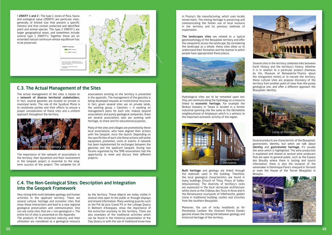
IE 1 2 The type 1 zones of ora, fauna and ecological value (ZNIEFF) are particular sites, generally of limited size that present a speci c interest and that contain protected and identi ed plant and animal species. The type 2 ZNIEFF’s are larger geographical areas, and sometimes include several type 1 ZNIEFF’s; Together these are an e tended natural continuum whose e uilibrium has to be preserved.
BOURG-EN-BRESSEBOURG-EN-BRESSEBOURG-EN-BRESSEBOURG-EN-BRESSEBOURG-EN-BRESSEBOURG-EN-BRESSEBOURG-EN-BRESSEBOURG-EN-BRESSEBOURG-EN-BRESSE
VIENNEVIENNEVIENNEVIENNEVIENNEVIENNEVIENNEVIENNEVIENNE
MONTBRISONMONTBRISONMONTBRISONMONTBRISONMONTBRISONMONTBRISONMONTBRISONMONTBRISONMONTBRISON
ROANNEROANNEROANNEROANNEROANNEROANNEROANNEROANNEROANNE
SAINT-ETIENNESAINT-ETIENNESAINT-ETIENNESAINT-ETIENNESAINT-ETIENNESAINT-ETIENNESAINT-ETIENNESAINT-ETIENNESAINT-ETIENNE
LYONLYONLYONLYONLYONLYONLYONLYONLYON
VILLEFRANCHE-SUR-SAONEVILLEFRANCHE-SUR-SAONEVILLEFRANCHE-SUR-SAONEVILLEFRANCHE-SUR-SAONEVILLEFRANCHE-SUR-SAONEVILLEFRANCHE-SUR-SAONEVILLEFRANCHE-SUR-SAONEVILLEFRANCHE-SUR-SAONEVILLEFRANCHE-SUR-SAONE
cartographie : DIREN Rhône-Alpes 31 juillet 2007
source des données : DIREN Rhône-Alpesfonds cartographique : (C) BDCarthage IGN/AEéchelle: 1 cm pour 4 km
Légende de Znieff2_2g
ZNIEFF de type 2
ZNIEFF de type 1
ZNIEFF rénovées
C 3 T A The actual management of the sites is based on a In fact, several geosites are located on private or municipal lands. The role of the Syndicat Mi te is to coordinate parties and their e orts to ensure a proper consideration of these sites and a uniform approach throughout the territory.
The importance of the network of associations in the territory, their dynamism and their involvement in the Geopark project is essential to the long-term success of the project. The complete list of
associations e isting on the territory is presented in the appendi . The management of the geosites is being developed towards an institutional structure. In fact, given several sites are on private lands, the working group « Geosites » is working on management plans for each site. Indeed, beyond associations and purely geological companies, there are several associations who are working with heritage, to share and for educational purposes.
Many of the sites and villages are promoted by these local associations, who have aligned their actions with the Geopark, since the launch. Depending on the speci cities of each site these actions will tackle e uipment, promotion, visits or events. A network has been implemented for e changes between the geosites and the applicant Geopark. During two forums organized by the SMB associations had the opportunity to meet and discuss their di erent projects.
Geopark oru ebruar
C 4 T G I G
Very strong links e ist between geology and human activities in the applicant territory. There are several cultural, heritage and economic sites that show these interactions and lead to a new regional geological preservation and communication. One can see some sites that are « non-geological ». The entire list of sites is presented on the Appendi .The products of the e traction industry and their utilization are considered as a geological resource
by the territory. These objects are today visible in several sites open to the public or through displays and shared information. Many working uarries such as the Pré de Jou Gravel Pit or the Lafarge Quarry in Belmont d’Azergues, show the importance of the e traction economy to the territory. There are also e amples of the traditional activities which can be found in the historical presentation of the Glay Quarry or with the use of traditional know-how
35 3636
in Prosny’s tile manufacturing, which uses locally mined marls. The mining heritage is preserving and communicating the former use of local resource in the territory and its previous methods of e ploitation.
T are related to a typical geomorphology of the Beaujolais territory and o er the viewpoints across the landscape. By considering the landscape as a whole, these sites allow us to understand their formation and the manner in which people have appropriated these places.
Hydrological sites are to be remarked upon too: they are communicating the hydrology as a resource linked to For e ample the Ninkasi brewery in Tarare is located in a former industrial spinning site the same as the Déchelette neighbourhood of Amplepuis which is a witness to the important economic activity of the region.
and geology are linked through the materials used in the building. Therefore, the local geological characteristics are found in many buildings (Church of Thizy, Priory of Salles-Arbuissonnas). The diversity of territory’s rocks are e pressed in the local vernacular architecture: white stone at the Château des Tours in Anse and in the Renaissance courtyards of Villefranche, golden stone in traditional building, castles and churches from the southern Beaujolais.
Moreover, the use of rocky headlands as for Montmelas Castleor the itinerant Pierres Dorées geosite shows the strong link between geology and historical heritage of the territory.
Several sites in the territory celebrate links between Earth History and the territory’s history. Whether it is in relation to a particular product (Hameau du Vin, Museum of Romanèche-Thorins about the manganese mines) or to narrate the territory, these cultural sites are propose discovery of the territory from another point of view than the purely geological one, and o er a di erent approach the Beaujolais’ identity.
Several products are characteristic of the Beaujolais’ gastronomic identity, but when we talk about
and it’s usually the wine which is highlighted. The wine production is e plained and shared at several wine producers that are open to general public, such as the Espace des Brouilly where there is tasting and tourist information; there is also the museum of the winemaker in Domini ue Paire’s vineyard in Ternand or even the House of the Terroir Beaujolais in Beaujeu.
astle o ont elas
Brewer inkasieig bour ood Déc elette
ine ard landscape
Ha eau Duboeu elter in dr stone
Prior o alles

Gene al nfo at on on t e te to
1 E A A T
The Pays Beaujolais with its bene cial geographical location in one of the most dynamic French regions has a great entrepreneurial and industrial culture. As is often the case, local resources have contributed to the development, and acted as the anchor, for traditional sectors. From these local resources have emerged sectors of the economy that have developed others: has inspired and led to a host of linked , the water uality has permitted the development of a te tile sector and the forest is being productively used.This territory, so close to Lyon still has a local economic activity which permits a sizeable proportion of the working population to work locally. Despite being so close to the Lyon metropolitan area, it is in a progressive manner that the territory is becoming residential. This new development, as much as it destabilises the relationship between employment and working people also presents a new opportunity to reinforce the by meeting the needs of the population by the .
The relatively virtuous, self-supporting economic model of the Beaujolais has su ered di erent crises and the various sectors have not always managed set themselves apart or to achieve local added value. All the local sectors that have largely engaged in subcontracting are now su ering from globalization. This is a simple observation but has motivated the socio-economic stakeholders of the Pays Beaujolais to support the local economy.T is without doubt an important strength for the territory.As such the Chamber of Commerce and Industry is at the forefront of the brand “Made in Beaujolais” which today is engaging with the wine world and the tourism sector. They are creating a shared
which is going to support the values of the territory and its companies. This brand corresponds to a coupled initiative with the Geopark project and
which will reinforce it through the promotion and communication of shared local values.
At the head of this project, the C has been working for the economic di erentiation of the territory since 2007. This association which is interested in all sectors has, as a rst goal to
nd answers to the wine crisis. Its objective is to stimulate economic intelligence and cross-fertilization between sectors by creating economic spheres between themselves and the university research world.As part of this mobilisation of the entire region to support the economic fabric, local institutions are involved and build on all the opportunities to sustain the local economy. As such, the territory bene ts from several national projects such as the contract of economic revitalization of the Pays de Tarare, or of its several centres of Rural E cellence (wood-forest and short cuts, etc.).
Finally, a speci c part of the territory has to promoted, the « Beaujolais Vert ». This dynamic and e emplary area has engaged in the European « » program over several generations and knows how to engage in e emplary cooperation projects. Today this area has engaged as a «
» territory for 2020, supported by the Rhône-Alpes Region which aims at putting local resources at the heart of the sustainable economic development of the territory.
1 1 T G C
1 2 A
The Applicant Geopark of the Beaujolais is a territory of contrasts, where the agriculture covers 44% of its entire surface. This activity is shapes the image and the lifestyle of the territory.
The emblematic crop which made this region world renown is the wine growing. With more than one million of hectolitres of wine produced a year and the festivities of the Beaujolais Nouveau, the Beaujolais is known worldwide.
37 38
But the territory is also produces many other goods that are distributed between the di erent areas of the territory: The R the only zone of the
territory dedicated to arable crops, orchards and vegetable production; , essentially dedicated
to wine growing and that consists of 12 appellations; a re ection of the terroirs’ richness: Beaujolais, Beaujolais Villages, and the 10 crus: Brouilly, Chénas, Côte de Brouilly, Chiroubles, Fleurie, Juliénas, Morgon, Moulin à Vent, Régnié, Saint-Amour. which culminate at
the Saint-Rigaud Mount. Free from urban in uences they reveal farming and forestry.
T are centrally placed in the Pays Beaujolais for their high uality wood production capacity and its direct contribution to the landscape heritage. Wooded lands cover 33.5% of the surface of the territory, this corresponds to 51 671 hectares and 35% of the departmental surface. Forestry is particularly prevalent in the valley of the River Azergues where conifer plantations (63% of wooded lands) are predominant. Douglas pine plantations are creating a speci c landscape: uniform and dark, giving a scale of “great landscape”, they are localised along the hill crests.
Therefore local stakeholders wish to rmly a rm the e istence of an often misunderstood forest heritage at the West of the Rhône-Alpes Region. They want to preserve the forest balance with better production management policies (diversi cation and sustainable production methods, landscape conservation, welcoming tourists, etc.).
Despite its strengths, the agricultural territory is weakened: dairy farming and wine growing are
facing serious structural di culties, essentially in the southern part of the territory. Competition linked to the growing impact of cities is adding to these di culties. This competition is related to agricultural heritage and land use, and puts at risk the agricultural preservation and communication within the territory.
These agricultural and forestry activities and practices are today rapidly changing. To address new challenges like the moving of the economy, environmental issues and the changes in the types of inhabitants, these sectors are changing. The e ample of a (facilities, activities linked to local products, leisure activities, management...) in Pays Beaujolais is a testimony of this evolution.
il iculture
ine ard
38
G W W
T
The vineyards of the Beaujolais are centrally located in the Beaujolais territory. With a large surface area (17 000 hectares), it is entirely located on the eastern border of the Massif Central, between the ridges of Haut-Beaujolais in the East and the Tarare Mountains further to the South. The vineyards largely dominate the hillsides which -slope eastwards to the River Saône. These vineyards and the wines they produce have a particular feature: they are made from a single grape variety (e cept for the white Beaujolais): the white juice of the black Gamay grape. These vineyards produce red wine; the typical “Beaujolais” wine, as well
as 12 protected generic designations (the 10 Beaujolais crus, the Beaujolais and the Beaujolais Village) which have a great diversity of characteristics.A wine is the fruit of the earth (soil and subsoil), of the climate, of a grape variety and of the know-how of the winemaker. Despite only having one grape variety and a similar climate for the entire area of the vineyards (even if many climate variations can be observed from the geographic location, topography and altitude), it is the geology and the pedology that gives this variety of terroirs. The history of the rocks of the Pays Beaujolais, which span more than half a million years, must not be forgotten as they have created the substratum of the vineyards. Geology and pedology thus play an important role in the characterisation and the identity of wines. The

famous geographer Elisée Reclus, in its work “New Universal Geography, Volume 2, France” published in 1877 highlighted the great feature of the vineyards : « Les vins du Beaujolais sont fort connus en France et à l’étranger. On a constaté ue tous les crus renommés de ces coteau sont obtenus sur un
lon de porphyre granitoïde ; ils ont une nesse et un bou uet particulier ui n’e istent pas dans les vins provenant des terrains carbonifères » (Reclus, 1877). Also, concerning the Beaujolais’ territory, Colette’s comment that the “grapevine is the plant that best e presses the taste of the earth” makes perfect sense.
T
such as that of Elisée Reclus in 1877, as well as the work of the Abbot René Mouterde in 1975 and 1976. Professor of Geology and Director of the Geology Laboratory of the Catholic University of Lyon, he carried out important studies on the Lias of the Beaujolais (Lower Jurassic, a series which followed the Upper Triassic and more speci cally the uppermost stage of the Upper Triassic, the Rhaetian). He undertook the cartography of the Beaujolais sedimentary cover with geologists from the University Claude Bernard, and speci cally Serge Elmi. This led him to pose the uestion: how can lands with a nature and a structure so di erent and yet so close due to signi cant fracturing, in uence the vines which grow above them, and therefore their wines? Oenologists underline that in the Beaujolais region of the “Pierres Dorées”, identi ed as a sedimentary cover, the wines taste of the terroir. Some researchers have been engaged and have conducted a Master’s thesis with the co-leadership of the ISARA (Agricultural Institute of Rhône-Alpes) and the CIBAS (Beaujolais Interprofessional Centre of Sensory Analysis) entitled: “Vines, Soils and Subsoils in Beaujolais” (Aline Guyou, Jean-Luc Parel, 1976). To conclude their report the authors highlighted that it is di cult to draw rm conclusions because they need to make observations over a number of years and apply a more detailed statistical method, such as a multi-criteria analysis. This analysis would make it possible to detect the in uence of the di erent factors, particularly the temperature. In a general way it can be said that vines that grow on granitic sands, schists and sandstones have many similarities; that the ones found above crinoidal limestone and the limestone with Gryphea are similar, and that the ones that grow above gravel and white limestone sometimes evolve one group and sometimes towards the another. More recently, the cross profession group has started a really important work on the vineyard soils of the Beaujolais. In fact, winegrowers have realized that the soils are an important resource and the necessity to have a good knowledge of them. “They initiated a fundamental action in 2009 in order to reinforce the links between people and their soils” (Letessier,
Marion, Curt et Gaudin-SIGALES, 2014). More precisely, this work had been started by the Moulin à Vent’s cru, and has been enlarged gradually by the UVB (Union of the Winegrowers of the Beaujolais) and the Inter Beaujolais who were the sponsors to the 10 crus and today to the entire Beaujolais vineyard area. This work on the soils have been entrusted to the rm of engineering consultants SIGALES who specialise in the cartography and the study of soils and terroirs (especially vineyards). The work is undertaken by geologists, pedologists and agronomists. The objective is to have a broad knowledge of vineyard soils, establish the di erent soil types and also to map them. Itaims also to communicate about the terroirs and the appelations. Even though the general types of Beaujolais soils were known, their variants and distribution were not. As Isabelle Letessier from SIGALES says : “ Even if key di erences can be used to distinguished two habitats, i.e. soils derived from crystalline rocks and those soils developed from clay-limestone rocks, when you take into account the impact of tectonics, metamorphism and alteration on a wide range of rocks, it is impossible to simplify”. Therefore this very thorough work has been carried out by the professionals from SIGALES with the support of the cross profession group.Up to now, more than 10 000 auger holes and 600 pro les of an average depth of 1.90 meters have been made across 13 000 hectares of the vineyards. In the near future, all the Beaujolais’ vineyard sectors will be covered by the studies that started in 2010 and will be completed in 2017. Progress in this work has led to the creation and the nalisation of a pedological map of the 10 crus and also to progress the soil study of southern Beaujolais.
T W 10 C
At the end of the soil study of the 10 crus, SIGALES has summarised where the links with the geology are strongly established and illustrated these results with soil maps. It has been identi ed that the soils of the 10 crus come from three major subsoil types: The most widespread soils develop from granite
rocks; they occupy more than half of the surface area of the crus Chiroubles, Fleurie, Régnié and Moulin à Vent, and under half of the surface area for the 6 other crus. Soils develop from the alteration of granite into Saprolite, which is commonly referred to as “gore”. It displays a wide variety of alteration and the modi cation into clays. Then in order of size of surface area, ne t are the
soils derived from deposits and ancient alluvium of the piedmont which constitute glacis or gently inclined plateaus. These are well-developed gravel soils, with more or less signi cant clay levels. They were identi ed on all the cru soils e cept for Chiroubles, and are well represented at Régnié, Morgon, Brouilly and Juliénas Soils developed from ancient volcano-sedimentary
rocks that have been more or less transformed
39 4040
commonly referred to as “”blue rocks” they have display schistosity or other forms of metamorphism. These soils can be encountered in the area of 5 crus: Côte de Brouilly, Juliénas, Morgon, Brouilly and Saint-Amour.
Each cru has its own “pedological personality” that is made up of a combination of these di erent soil units and nuanced with local variations. These soil covers e tend over rounded relief and changing from one cru to another. The slope, orientation, energy received by the soil, aeration and shelter from prevailing winds di ers from one cru to another, but also between local districts. All of this is a rich palette that permits the winegrowers to e press themselves; their aspiration, know-how and speci c character are e pressed in the nal wines, and no one can say that they feel they make the same products on these di erent soils...Hereafter, there is the summary description of each of the Cru’s soils.
R is one of the most granite rich Cru soils, followed by Chiroubles and Fleurie. The varied slopes of the area result in soils at di erent stages of development. Several hills are capped by evolving ancient super cial formations composed of gravels or big scattered sandstone blocks that complete the granite terroir area with their deeper soils that contain more clay at depth. Régnié is a fragrant, rounded wine.
is the most typical cru developed over a granite soil. More than 90% of the soils are directly
developed from pink granite with numerous, thin veins (dark lamprophyres, microgranite and uartz). Due to subtleties in its evolution, when small amounts of clays begin to form at the e pense of the large granite crystals, as well as the orientation of the granite soils and the shape of the slope, sometimes the depth of the soil can be considerable. The Fleurie gets its intense crimson colour, its oral and fruity aromas of iris, violet, rose, red fruits from the pink granitic soil.
has the second biggest vineyard after Brouilly which e plains the diversity of its soils. The three main terroirs of the crus are well organized because the soils developed from the granite cover all the hillsides from the village of Villé-Morgon to Corcelette and Saint-Joseph, those of the “pierres bleues” group are concentrated at the top and on the eastern slope of the Côte du Py. They are progressively covered to the east by piedmont formations and reworked ancient alluvium. Then, a curious ribbon of clay with blocks covers the granite and snakes through the ledge between Morcille and Douby (SIGALES, 2014). In reference to the village of Villié-Morgon that nestles in the heart of the Beaujolais Cru area, Morgon has a deep garnet colour and gives o ripe stone fruit aromas including cherry, peach, apricot and plum.
C the soils on which its vines grow are remarkably homogenous : the pink granite that is cut by little veins of dark lamprophyres and
uartz, constitutes the only parent material for the soil. Backing up on the Beaujolais Mountains, this appellation is the highest altitude of the 10 crus. Wine growers, champions of anti-erosion techni ues, are working on the thinnest, sandy soils (SIGALES, 2014). Because the temperatures in Chiroubles are lower than in other areas of the Beaujolais region, the harvest here is later, around a week after the proclamation of the start of the harvest for the Beaujolais vineyards. Chiroubles has a ruby colour and aromas with oral bou uet (violet, iris, lily and peony).
A Ancient alluvial clays, inty clays, granite, schists, diorites, Triassic sandstones, and also some calcareous rocks combine to give an e traordinary diversity to the soils of this cru. It is the smallest of the 10 Crus. Elevations are grouped together at between 240 and 320 meters, and the average slopes are more moderate than those observed in the other crus (SIGALES, 2014). From the granite, clay and schist soils of Saint Amour there are two types of wine produced with sparkling ruby red colours, which have fruity and oral avours.
C This is a product soils developed over diorite and schist. The soil on the anks of Mont Brouilly are formed of alternating blue stone and marbled dark green stone called «corne verte».

The rock’s alteration is more into a silty-clayey soil than the sandy and gravely soil developed over the granites and that is present on the western slopes of the Mont Brouilly (SIGALES, 2014). Côte de Brouilly displays a crimson colour with aromas of fresh grape and iris.
C In the municipality of Chenas to the west there are rough granite slopes, an e tension of those of Moulin à Vent. Around the municipality of La Chapelle-de-Guinchay the land slopes less and is formed of a wide granitic outcrop which disappears to the East under ancient alluvium with small pebble horizons (SIGALES, 2014). Located between Chénas in the Rhône Department and La Chapelle-de-Guinchay in the Saône-et-Loire Department, Chénas has a ruby colour with garnet hints, oral aromas of peony and rose, and is nuanced with spicy and woody notes as the wine ages.
Some granite derived soils, but many soils developed from schist and diorite that are on the largely open slopes that face south. They disappear to the east and are replaced by ancient alluvium and underlain by clayey subsoil. The resistant Triassic of the Mont de Besset is formed of Triassic sandstone and gives di erent soils (SIGALES, 2014). This area is without a doubt at the origin of the Beaujolais region’s wine growing vocation. With the greatest variety in terrain of all the Beaujolais wine growing area, this cru has a deep intense ruby colour, with aromas of strawberry, violet, cinnamon, red currant, and peony
this cru is nourished by crumbly pink granite rocks that are also called “gore”. They are crossed through with seams of manganese that are, without a doubt, behind the wine’s characteristics. For interest, it has been noted that some hectares of marls have been discovered to the e treme east of the appellation area, these are the most calcareous of the Beaujolais (SIAGLES, 2014). The Moulin-à-Vent appellation area is spread over just 2 communes; Romanèche-Thorins in the Saône-et-Loire Department and Chénas in the Rhône Department. Set around a colour that ranges from deep ruby to dark garnet, this wine gives o oral and fruity aromas of violet and cherry.
The most widespread and southernmost of the Beaujolais Crus gets its name from the hill Mont Brouilly. This covers the area of 6 municipalities and its singularity is that none of the communes in the appellation bear its name. All the varieties of the cru’s soils are represented in this area: pink granite on rough slopes, clay screes of “pierres bleues”, siliceous volcanic or schistose rocks, ancient and gravely alluvium, limestone hills, etc.(SIGALES, 2014). Much in uenced by its 4 terroirs which oscillate from a bedrock of pink granite to that of calcareous clay, Brouilly is clothed in a deep dark intense ruby colour, with aromas and avours that are more fruity than oral, with forthright red fruit, plum and a few mineral notes faithfully reproducing the Gamay bou uet.
411
The name « Beaujolais » is known worldwide for its wines. Despite this international reputation, the lands of the Beaujolais remain secret...
Between mounts and hillsides, the Pays Beaujolais displays . It spreads
from the e treme South of the Saône and Loire Department to the gates of Lyon. This is a colourful territory: those of the golden stones villages, of the hillsides, of the Val de Saône the ruby coloured wines. This is why from a tourism point of view the Beaujolais is divided into 4
1 3 T
4242
C
The Pays Beaujolais covers an area of about 1550km2, that is to say the northern part of the Rhône Department.
T has been one of in the emergence of the Pays
Beaujolais. This tourism presents a dimension with a varied offering
of accommodation and eating establishments. The Pays Beaujolais has a total accommodation
35 000 including: A commercial accommodation capacity of 10 000 beds, an offer which is well represented by
with farm accommodation in rural areas (cottages, bed and breakfast) and particularly in the vineyard sector. A great capacity of non-market accommodation (second homes), about 25 000 beds.
In 2012, an estimate of the total number of nights spent in the Pays Beaujolais lies at around 1.4 million. This ranks the Beaujolais as
which is listed in the UNESCO World Heritage.
Tourism related income, although it is difficult to value, stands at about 50 million Euros in the Pays Beaujolais (400€ million for the entire Rhône Department).
Tourist traffic is spread over a fairly long period of time, since the season is spread from April to October. The Beaujolais region has the two peak periods of fre uentation: the first one is in JulyAugust, and the second one in November at the time of the “New Beaujolais Feasts”.
The Pays Beaujolais has a , focused mainly e cursions, transit tourism and short breaks. The clientele is made up mainly of French people (76%) coming from the Rhône-Alpes Region (30%) and from neighbouring Regions (20%). This e plains the significant proportion of non-market accommodation in the territory. However, the of the Beaujolais and its in the centre of European allows us to target foreign clients (24% of the visitors) who come from neighbouring countries (Belgium, Netherlands, United-Kingdom and Germany are the most represented). It is in November that the Beaujolais welcomes most international visitors, with almost 60 different nationalities.
The range of sites and tourist activities is relatively diverse: natural sites where outdoor sportsare practiced, recreation, family holidays, cultural and heritage sites, oenology and gastronomy, waterway tourism etc. Within the many themes offered in the territory the 4 main sites of attraction are: the Pine Lake, Touroparc, the “Hameau du vin en Beaujolais” and the Paul Dini Museum.
Paul Dini s useu

The Pays Beaujolais is very much a hiking territory and has more than 1600 kilometres of marked paths for many activities: hiking, horse riding, bike riding (with bike trails approved by the National Federation), self-stabilising scooter etc. Between mountains and valleys, across hillsides these little roads and winding paths are playgrounds for cyclists of all levels. The e cursions are either self-guided or accompanied by an educational guide, a naturalist or trained personnel. Other outdoor activities can be practiced, such as rowing, sailing, kayaking, climbing, speleology or rope paths, shing activities, etc. Seen from the sky from an aircraft, the Beaujolais is a magical territory revealing its landscapes.
The remarkable natural heritage of the Beaujolais is protected and enhanced in several ways:The Sensitive Natural Area of the Val de Saône and 15 other sites listed for their landscape ualities ; Nombre Sensitive Departmental Natural Areas; 34 “ ower” towns and villages, the Rhône Department also being recognised as a “ ower” Department ; Nombre of remarkable parks and gardens ; The village of Fleurie has been designated as a holiday “Station Verte” ; 14 villages have committed to the Agenda 21 project of the national society “Notre Village” as approved by the MEEDAT (Ministry of Ecology, Energy, Sustainable Development and Country Planning).
The applicant territory has 21 which have been born from the passion of great collectors, dedicated to inventors, and to traditions that have forged the Beaujolais.
In addition to the museums there are many and as well as a remarkable and varied architectural heritage. So many elements that illustrate the richness of the Beaujolais subsoil which punctuates the characteristic villages at the heart of Beaujolais, encouraging you to journey through time. Within these sites, we can nd:Oingt, the Most Beautiful Village in France ; The 2 Cluniac sites of Salles-Arbuissonnas and Saint Mamert ; Nombre protected buildings classi ed as historic monuments ; A hundred of castles from
the 10th to the 20th century ; The territory of the Pierres Dorées awarded the label «Vignoble et Découvertes» by the national association Atout France; Famous vineyards with its 12 renowned appellations.
Furthermore, the agenda of the Pays Beaujolais is rich in which have an impact from the local level to the international level. Local products are often at the heart of the activity, such as during the C or the
. This takes place in November and attracts more than 50 000 visitors. In the same way, the two main cultural festivals (“Continents et Cultures” in Beaujolais and the festival of the watercolour artists of Bagnols) each attract between 10 000 and 12 000 visitors. Other unifying popular events based on ; such as the festivals of the in Tarare, the
C in Villefranche or even the festival of mechanic music in Oingt.
There are also the sporting events of international and national notoriety that attract also many people (Pine Lake Triathlon, Beaujolais International Marathon, Raid Aventure Beaujolaise etc.) which reinforce the image of the Pays Beaujolais as a territory dedicated to outdoor leisure and sports.
Elected o cials and local stakeholders had become aware of the necessity of working towards sustainable tourism which o ers satisfaction to visitors and local stakeholders. Therefore the appropriation of the wealth of natural and local heritage through the projects for preservation communication is a key point in the development strategy of the Pays Beaujolais. Globalization in tourism imposes a need to diversify in order to distinguish the Pays Beaujolais from other destinations. The position taken by the Beaujolais since 2008 and the implementation of its development scheme is to diversify the tourism o ering, without altering its identity. The development of the tourism o er needs to be continued, based on the assets of the oenotourism, geotourism, ecotourism, etc.
43
Bagnols castle
Vague des Conscrits
e walking esti al oBeaujolais Vert ou n ature Crédits Lac des apins ourist O ce
Oneotouris Guideto t e Beaujolais Crédits nter Beaujolais
Hobbies and Heritage Guide Crédits Beaujolais Vignoble ourist O ce
44
In the Pays Beaujolais, industry represents 19% of employment, a decreasing gure, but still higher than the departmental, regional or national average. The industrial sector is based on traditional territorial activities such as metallurgy, plastics, te tile and the food industry.Even with the presence of some large companies here (Bledina, Bayer...) the is composed of E and many subcontractors. The is concentrated at several , notably in Villefranche-sur-Saône where the “National Street” amazes due to its commercial dynamism, the diversity of its shops and the commitment of its merchants to the many events that take place throughout the year. In Villefranche-sur-Saône we can also nd a covered market, which is the largest food market hall in the region, which gathers 80 merchants ve days per week.
With the decrease of rural and factory workers and the increase of employees and managers, today we see the in the Beaujolais.The Beaujolais is a borough with a sub-prefecture and as such a number of public administrations and institutions are focused here. This e plains the 27% of jobs within the elds of , education, health of social services.The , based on an important productive base (43% of employee jobs) but with support from the residential economy growing (37% of employee jobs) and the public sector (20% of employee jobs) which allow the territory to bear the e ects of economic crises.
1 4 C I T
44
2 E I
Within the Geopark Beaujolais territory we can mention the
and discovery of the Earth’s history.
T E the Espace Pierres Folles is the showcase for thegeology of the territory. Located at the heart of the golden stone countryside, near to the Lafarge
uarry, the museum is open to the public from the 1stopen to the groups by reservation during the whole year. This museum of palaeontology, as well as core and applied geology o ers a fairly complete discovery of the various facets of Earth’s history (stratigraphy, palaeontology, palaeoecology, etc.) and of applied geology (mineral resources, use and transformation, oenology). The museum also highlights the essential resources of the territory for man, its habitat, its heritage and its economic development. The free-access geological path has been developed with interpretative e uipment and invites you to discover the regional geological history through spectacular objects. The botanic garden is located in the area of the former uarry
and is also free-access. It includes about 530 species of regional ora whose diversity is the fruit of variety of soils and geology. This garden is sponsored by “Botanic Gardens of France and Francophone Countries”.
T G has been developed as a pedestrian path and dotted with interpretation panels which e plain the e traction and stone-cutting and the human history of the site. This a
2 1 E
Garden o t e useu o t e Pierres olles
nterior o t e Pierres olles useu
Gla s uarries

T G
Throughout the year geologically based activities and events such as conferences, meetings and visits are organized through the initiatives of local association’s and the Espace Pierres Folles. We can mention the “Marche des Caillou ”, organized by the association”Itinéraire Paysage et Patrimoine”, which has been successful for its second edition in 2014, or the organization of the “Fête de la Pierre” by the association of “Les Amis des Carrières de Glay”.
The SMB has also worked with the managers of geosites and the Tourist O ce to implement visits during the summer. These actions will be developed
over the coming years in order to anchor the geotourism activities of the territory.
45
good e ample of rehabilitation of a former uarry. Classi ed as sensitive natural habitat (ENS) by the Rhône Department, the Glay Quarries are free-access and animated by the association “Amis des carrières de Glay”.
T has been improved and is occasionally open to the public, it is a former argentiferous galena mine. Managed by the association “Patrimoine en Haut-Sornin” for the tourism aspects and by the association “Terre et Nature” which specialize in speleology and chiropterology.
T G 9 kilometres long, this free-access path runs across thelimestone mountain that overlooks the city of Lyon. Dotted with interpretative panels and panoramic tables, this path allows the discovery of landscapes and formation of rocks constituting this mountain.
T is the viticultural mountain of Beaujolais and is an important tourist area within
the territory. Facilities have been put in place during 2014 in the Charte de Fontevraud framework
provide visitors and walkers with a better idea of the landscapes and the various components of the territory.
T is a lake dedicated to tourism. It has become a major site of the Rhône-Alpes Region with more than 300 000 visitors per year. The site includes both a lake of more than 38 hectares and a natural space for bathing. Since its creation, the Pine Lake provides many facilities for outdoor leisure activities.
The animal park T in Romanèche-Thorins is mainly centred on today’s living world, but a museum area covers the topics of local history, and the history of the manganese mines.
T is located in Romanèche-Thorins and is a famous museum dedicated to wine,its promotion, production and history. Geological and educational themes are developed there which relate to Beaujolais local products, in order to highlight characteristic “terroirs” of the applicant territory.
Beyond the facilities e isting in the territory, there are tools allowing the development of territorial identi cation, preservation and commination. The inter-municipality Beaujolais Val de Saône, for instance, is setting up a support and rehabilitation program for the vernacular heritage throughout its action area.
Pine Lake
tone esti al in t e Gla s uarries
2 2
Within the framework of the Geopark project, many new projects are being developed. Among them, the have been mentioned. On the Mount Brouilly for instance, a
is being created the discovery and interpretation of the main geological themes of theregion. At the same site an addressing fauna, ora and geology is in construction.
Other ideas are being studied: in the former uarry of Cours-La-Ville the municipal council has voted to create an area of
; the former white rock uarry of Lucenay has proposed a new site for e ploring the stone and uarry professions. Some are being created: the travelling geosites of the Pierres Dorées is an itinerary that involves many municipalities and points of interest in the south of the territory and has been built with various associations and stakeholders. The itinerary needs to be sign posted
so people can easily visit it.The potential of numerous projects remains to the evaluated; this is the case for the
of certain mining sites or sites made available by communes such as the Chapel of Saint- Roch à Bagnols which could become a new dedicated geoaprk e hibition centre.
The idea of creating a G C has already been raised during the setup of the project. This could be built at Grange-Charton, a former vineyard of the Beaujolais. In the same way, the idea of creating an has been mentioned: the aim is to help to forge a link between works of art and geosites, enlightening the territory with a new dimension and thinking to the Earth’s history and heritage.
46
aint Roc c apel Morguières
Régnié Durette grange C arton
46
3 A A G
For a long time, the Pays Beaujolais has o ered geotourism without knowing it, especially with all the aspects linked to the “terroir” and the heritage. The project working towards the entry into the Geoparks Network has been a real catalyst for ideas, wishes and projects which identify and endorse the riches of the territory, especially its geological wealth.
G
The geotourism themes in Pays Beaujolais have already been established: the discovery of “terroirs” and heritage. These are the two aspects that e pand on the geology of the territory by means of human activities.
E
The study characterising the “terroirs” which underline the clear link between pedology and local produce, and the education and awareness raising which will be set in place at the end of the study, serve to illustrate this workstream.
A
The Geopark project permits coordination and gives a common sense to many initiatives, with more clarity and visibility. Within the e amples of projects, we can highlight the will to create a shared calendar of guided tours, e hibitions and other events around Geopark, in order to implement a network of geosites and places to visit.

The territory of the applicant Geopark Beaujolais corresponds to the area of the SMB. As a result, some of the public policies and projects promoting the sustainable development are supported or followed by the institutional structure.
Within the framework of the CDDRA, the territory is engaged in a
Several action plans in this contract have as a main theme the natural areas, the agricultural and forest spaces, the preservation of green and blue belts (listed in the Regional Ecological Coherence Scheme (SRCE)). To pilot this contract, the SMB is drawing on the Local Development Council, and has putting the populations participation at the heart of this commitment.
The « Green Beaujolais » part of the territory is engaged in a Leader program with the European Union which supports a much more proactive project. The objective is to become a TEPOS territory (a zero net energy territory) by 2050.
Moderation, energy e ciency, as well as renewable energy production (wood, wind power, methanisation etc.) will be the main elements of this dynamic policy. In this conte t of these actions and the Leader program, the territory is participating in debates at a European level, because it is part of the R
(Network of rural communities for energy neutrality) and has put in place between di erent LAG’s (Local Action Group). More than thirty municipalities in the territory have committed to an A 21 approach by undertaking assessments and by putting in place action plans to develop sustainable development.Also the whole territory is covered by climate and energy plans (Plan Climat Energie Territorial, PCET) which allow real strategic coherence with the aim of achieving the 3 20 that was set by the Grenelle Environment Forum.
4
5 A E in the application project. With no internal capacity to realise this workstream, the SMB have opted to approach strategic stakeholders to work on this theme. The applicant territory has the chance to have the Espace Pierres Folles, which is, thanks to its skilled team is an educational resource centre. Indeed, the Museum is a major resource which welcomes many school audiences from the entire region and o ers local geology discovery workshops. The Espace Pierres
Folles is a territorial reference in scienti c mediation.Moreover, the E
pursues several purposes to develop and support the activities of this type. The rst stage of the action is to be implemented at the start of the new school year, with the support of territorial educational stakeholders (head teachers, teachers, professional education consultants etc.).
47
ATOUTS HANDICAPS
INTERNE
Diversity of geological and heritage resources Appropriation and engagement by local stakeholders in the Geopark
Project Development of a family o ering to discover the territory in an
entertaining manner An easy access territory (European North-South a is) at the
immediate vicinity of a large European metropolitan area (Lyon) An internationally famous wine region Tourism with limited seasonality ...
W Abundant and varied
geological resources, but less striking and visible than in mountain zones Limited institutional
management of geological sites of interest ...
EXTERNE
An important pool of local tourists interested in short stays: an o er
which is already in place Numerous partners and local stakeholders to take up geotourism Visitors searching for meaning, well-being, intelligent and
entertaining discoveries. ...
T Land pressure linked
to the pro imity of the metropolitan area and the uality of the living conditions ...
48
But many stakeholders already work to raise the awareness of visitors and inhabitants to the natural environment and the wealth of the territory. The network of local associations is working towards this, in the same way as outdoor activities can be a way of discovered. Indeed the network of uali ed guides, with for instance the associations “Amis Guides en Terre Beaujolaise” or “Déambule”, propose
the discovery of natural and cultural heritages. The Rhône-Alpes Natural Area Conservation body (CREN) o erings its own visits and awareness raising activities at several fragile
and threatened sites.
48
6 A R I
There are di erent institutions based in the applicant Geopark or working in its territory, most of them are working with the project. Generally they are aware of what’s happening in the project and are collaborating on identifying, preserving and promoting sites, or undertaking scienti c studies; alternatively some are promoting sites to the public though geotourism activities which are orientated around a number of themes and to di ering audiences. This section gives a short overview of the essential stakeholders whose works are essentially based on geology:
A A C A AC the AMAC is an association (in the sense of the law 1901), created in 1976 by a mineralogy enthusiast. Developed over the years by geology, palaeontology
and volcanology e perts, its researches are focused on the regional heritage, especially Chessy’s minerals: azurite, malachite, smithsonite, chrysocolla etc. In 2014 the association had 80 members
from the Lyon area, but also from Languedoc and Switzerland. The association aims to maintain a spirit of e change through conferences and discussions between national and international societies etc. A section devoted to children has been in operational for a few years. Among the agship activities of the AMAC, we can mention the annual mineral club e change, the international club e change of l’Arbresle, the creation of e hibitions on re uest, conferences and meetings with other national and international associations. Members are participating today to create a geological path and are working closely with the municipality of Chessy and the Geopark project.
T A E the entire Espace Pierres Folles (museum, geological
path, botanic garden) and its activities are managed by an association (in the sense of the law 1901) with a hundred members. This association, born as a result of the redevelopment project of a former uarry, has worked towards the reconversion of the site to create a geological path, a botanic garden and the building of a museum dedicated to local geological and paleontological heritage. Today the association manages the site: maintenance, promotion, activities such as conferences,e hibitions, open days, events, etc. It also facilitates improvement of knowledge of the local heritage by information-gathering and tourism projects linked to the local communities and organisations.
T G W C
in 1962, with the beginning of industrial activity of Lafarge cement plant, the uarry was fre uented by amateur fossil hunters and scientists with the authorization of the company. In 1979 a Geology and Palaeontology Section was created within
the Lafarge Work Committee, with management approval. This section brings together 90 members. It o ers several activities : eld trips to the uarry site of Belmont d’Azergues, annual field trips in

to the uarry site of Belmontd’Azergues, annual eld trips in France or abroad, “inter-clubs” welcoming both French or foreign societies, e hibitions shown in various places in the Department, conferences, scienti c publications linked to the Claude Bernard University, participation to the life of the Espace Pierres Folles museum (creation of a stratigraphic column, participation in the construction of a Diplodocus sculpture in the children’s play area, fabrication of a copy of the ichthyosaurus etc.).
T A this association (in the sense of the law 1901) was created in 2010 and aims to identify and
communicate the paleontological and geological heritage of the Lyon area.
Prospection and e cavation missions are undertaken by a team of scientists. The association plays a mediating and coordinating role between local municipalities, land owners, collectors, museums and universities. The objective is to allow the communication of research discoveries through publications, e hibitions and conferences, whether specialized or for the general public. Since 2009 the association has organises eld missions in the Lafarge uarry site.
Many others associations are working within the Geopark project to o er discovery activities in the territory. The complete list is presented in the appendi .
E Inte est an A ents fo Jonn t e EGN
E 1 T I E G
The Geopark label will bring the territory a ualitative recognition, in addition to a real opportunity to develop and reinforce the territories geotourism. Moreover, the identi cation, preservation and communication of the geological sites through educational and mediation policies is an important point. Beyond these objectives and the geological theme, the Geopark project in Beaujolais enables the
, based on a network of stakeholders and partners. The Beaujolais, in targeting these territorial policies is seeking to become and remain an innovative territory. This
can be seen through its sustainable development ambitions or its wish to become a zero net energy territory by 2050, or through the establishment of its community participation and the involvement of as many people as possible.
The applicant Geopark project is therefore at the middle of the other policies led by the SMB, as it has cross-disciplinary themes. It will both create and reinforce the links e isting between public policy, associations and civil society around a common theme which is the base for a coherent territorial identity.
E 1 1 T T
E 1 2 A I The integration of the Geopark Beaujolais in the European Network will allow e changes with many other active Geoparks in European or International territories. These e changes about good practice or within the framework of special events can
e pand the cooperation and reinforce the Geopark network of geological heritage preservation and communication at a global scale. For instance it is very interesting to know and incorporate where possible, the tools implemented by other Geoparks,
49 5050
especially in the domains of communication and education. Indeed the actions led by the Azores Geopark concerning environmental education already serve as e ample for the implementation of tools suited the Beaujolais Geopark.
The initiative set up by the Katla Geopark, the Shetland Geopark, the Stonehammer Geopark and the Magma Geopark titled « Geo2Nor » regarding developing tourism and coordination of their communication means is also a good illustration of the advantages bringing the belonging to this type of network. Since the launch of the project in 2012, the Beaujolais territory the lead in the Geopark project, has participated to the 12th European Geopark Conference and the 6th International
Geopark Conference and has presented the Geopark project on these occasions. Moreover, in the events that have taken place in the territory, other French Geoparks have been invited. Indeed, during the 1st Geopark Beaujolais forum the Bauges Geopark was invited to speak about its e perience. In the same way, during the second Geopark Beaujolais forum, the Natural Regional Park of Monts d’Ardèche, an applicant Geopark came to present its application and talk about the work it had carried out. Thus the project of the Beaujolais is not only a local project, but ts in a participative and partnership approach to create and formalise a sustainable network of e changes with other territories.
Actions of identi cation, preservation and communication are already underway at certain sites and geosites in the applicant territory. At the same time plans for site management are in the process of being nalised thanks to the cooperation of local stakeholders and the “Geosites” working group. In these ways the territory wishes to invest to develop its activities to promote geotourism and the discovery of geological heritage. In the frame of an amendment to the Contrat de Développement Durable of the Rhône-Alpes Region made in 2014, will be oriented to the Geopark to help in the development and the communication of the sites.
The integration into the European Geopark Network will con rm the suitability of these rst actions and will reinforce the determination of elected people to strongly invest in the Geopark’s development. Given the keen interest of people in the territory, the Syndicat Mi te du Beaujolais also provides the formalization of an concerning all local stakeholders engaged or interested in the project. The network is already set up with stakeholders that have participated in the project directly or indirectly, and those who have supported the project via the support cards which have permitted the SMB to establish a complete directory for distributing information. This willingness to take action as a partnership allows, beyond the support of local people, the emergence of projects: creation of speci c geotourism products (Association “Atouts Beaujolais”), training guides on geological themes, etc.
The territory is also engaged in a university research program through a CIFRE contract. This PhD thesis, which will be published in 2017,
concerns the Geopark project, and is linked to the French network of the Geoparks (Bauges Geopark, Réserve Géologi ue de Haute-Provence, Chablais Geopark, Geopark des Monts d’Ardèche, Geopark du Lubéron) and European Geoparks (Arouca Global Geopark, Geopark de la Catalunya Central).
Finally, the singular identity of the Beaujolais that stems from its geological diversity and the wealth by which this is e pressed throughout the territory will be a powerful asset. In e ect, it can be set apart from other Geoparks, notably those in France by the use and strong ownership of the geological wealth by its inhabitants, which is seen through its famous
ne wines. This speci c feature gives our territory its wealth and individuality, and we hope it will take its place at the heart of the prestigious sites that today make up the European Geopark Network.
E 2 R EG
upporting card to t e Geopark project

Bblo a e s lect e
Falsan & Chantre (1879) - Monograp ie géologi ue des anciens glaciers et du terrain errati ue de la partie o enne du bassin du R ne. Imp. Pitrat, Lyon, 2 vol., 622 pp. et 572 pp.
Joannes C. (1981) - Le district lonien de Beaujeu (Rhône). tude géologi ue. Thèse 3e Cycle, Orléans. Lacroi P. (1980) - Géologie du groupe de Viola (Rhône) : contribution à l’étude des granités sodi ues et
des formations éruptives et volcano-sédimentaires associées. Thèse 3e Cycle, Lyon, 169 p. Peterlongo J.M. (1960) - Les terrains cristallins des Monts du L onnais (Massif Central français). Thèse Doct.
Sc., Clermont-Ferrand, 187p. Rigaud J.P. (1985) - tudes des or ations dé ono dinantiennes du Beaujolais éridional. Thèse 3e Cycle,
Grenoble. Rousselle B. (1996) - Partition stratigrap i ue des aciès et des olu es de dép t en do aine de plateor e carbonatée. E emple dans l’Aalénien du Sud-Est de la France. Doc. Lab. Géol. Lyon, 143, 225 p. Rulleau (1989) - Les Gra oceratinae du oarcien supérieur de la région l onnaise. Thèse de Doct., Lyon, 218 p. Savoye (1899) - Le Beaujolais préhistori ue. Rey imp., Lyon, 214 p. Sider H. (1985) - olution d un seg ent de la c a ne erc nienne dans le ord Est du Massi Central ranais Région du Beaujolais. Thèse de Doct., Nancy, 373 p. Suan et al. (2013) - Palaeoen iron ental signi cance o oarcian black s ales and e ent deposits ro
sout ern Beaujolais, France. Geol. Mag., FirstView, pp. 1-15. Vincent et al. (2013) - Marine ertebrate re ains ro t e oarcian alenian succession o sout ern Beau
jolais, Rhône, France. Geol. Mag., FirstView, pp. 1-13. Vitry F. (1982) - La bordure orientale du Massi Central au Lias in érieur dans le Mont d Or l onnais et le
Bas Beaujolais. Thèse 3e Cycle, Lyon, 183 p. Vuagnat P. (1984) - L a as sul uré de C ess (Beaujolais méridional). Thèse 3e Cycle, Lyon, 137 pp.
Liste des gures : A
Figure 1 : SMBFigure 2 à 6 : Espace Pierres FollesFigure 7 à 11 : J. C. DuboisFigure 12 : Mairie de Jassans-RiottierFigure 13 à 14 : G. Blanchet Association Météorologi ue d’entre Rhône et LoireFigure 15 à 16 : P. Gadiolet SMRPCAFigure 17 à 28 : J. C. DuboisFigure 29 : SMBFigure 30 : Mairie d’AnseFigure 31 : OT VillefrancheFigure 32 à 35 : SMBFigure 36 : D. Duvernay Information agricoleFigure 37 : A.M.Yordanova Pays des BrouillyFigure 38 à 39 : SMBFigure 40 à 41 : J. C. Martin Association IPPFigure 42 à 43 : SMB
Figure 44 : Espace Pierres FollesFigure 45 : J. C. Martin Association IPPFigure 46 : Mairie de CharnayFigure 47 : Mairie d’OingtFigure 48 à 51 : Espace Pierres FollesFigure 52 : AMACFigure 53 à 54 : Espace Pierres FollesFigure 55 : France 3Figure 56 à 57 : Espace Pierres FollesFigure 58 : Suzanne CeyzeriatFigure 59 : Granulat VicatFigure 60 : OT Pierres DoréesFigure 61 à 64 : Espace Pierres FollesFigure 65 : SMBFigure 66 : J. C. Martin Association IPPFigure 67 : Espace Pierres FollesFigure 68 à 69 : SMBFigure 70 : Granulat VicatFigure 71 : Château de Bagnols
C Figure 72 : SCOT SMBFigure 73 : Association des Amis des Carrières de GlayFigure 74 : Département du RhôneFigure 75 : DREAL Rhône-AlpesFigure 76 : SMBFigure 77 : A. M. Yordanova Association Pays des BrouillyFigure 78 : Brasserie NinkasiFigure 79 : CCORFigure 80 : OT Pierres DoréesFigure 81 : D. D’Harcourt Château de MontmelasFigure 82 : Hameau DuboeufFigure 83 : SMB
Figure 84 à 85 : SMBFigure 86 : SIGALESFigure 87 : Destination BeaujolaisFigure 88 : Association des SarmentellesFigure 89 : Musée Paul DiniFigure 90 : Château de BagnolsFigure 91 : Mairie de VillefrancheFigure 92 : Association Beaujolais RunnersFigure 93 : OT Lac des SapinsFigure 94 : Inter BeaujolaisFigure 95 : OT Beaujolais VignobleFigure 96 à 97 : Espace Pierres FollesFigure 98 : Association des Amis des Carrières de GlayFigure 99 : Syndicat Mi te des Monts d’OrFigure 100 : OT Lac des SapinsFigure 101 : Association des Amis des Carrières de GlayFigure 102 : Samuel AurayFigure 103 à 104 : Association les Amis du vieu BagnolsFigure 105 : Association IPPFigure 106 : SMBFigure 107 : PCETFigure 108 : Espace Pierres FollesFigure 109 : Syndicat Mi te des Monts d’OrFigure 110 à 111 : CE LafargeFigure 112 : Paléorhodania
E Figure 113 : SMB