Appendix G. SAC Meeting Notes & Public Involvement · Sept 2015 Dec 2015 Meet w/Pedestrian Safety...
77
State Routes 59 and 45 Pedestrian Safety Study Appendix G. SAC Meeting Notes & Public Involvement
Transcript of Appendix G. SAC Meeting Notes & Public Involvement · Sept 2015 Dec 2015 Meet w/Pedestrian Safety...

State Routes 59 and 45 Pedestrian Safety Study
Appendix G. SAC Meeting Notes & Public Involvement

SAC Meeting 1

Meeting Note Route 59 & 45 Pedestrian Safety Study Study Advisory Committee (SAC) Meeting
Date: October 14, 2015
Time: 10am – 12pm
• Welcome and Introductions
Sandra Jobson, from NYSDOT, welcomed the Study Advisory Committee (SAC) to the first meeting. The attached agenda was distributed. Each attendee stated their name, company/organization and project role. The committee was represented by federal, state, county and local governments, town officials, law enforcement, health, and transportation consulting team. See attached copy of attendance sign‐in sheet.
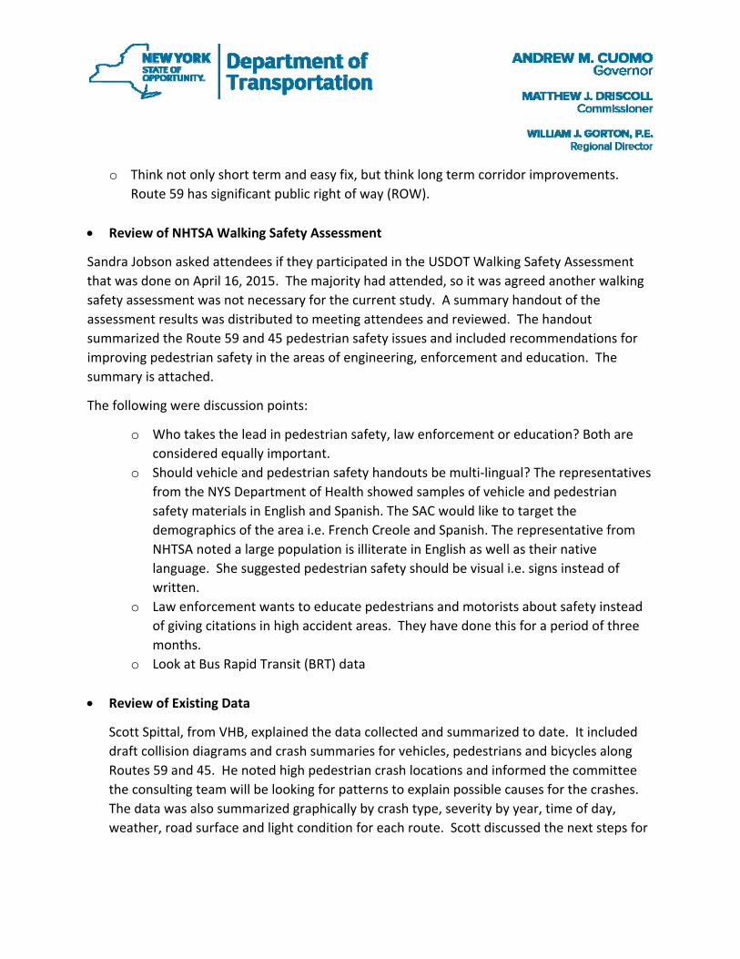
• Study Schedule & Structure
Sandra Jobson gave a brief project overview and explained the study flow chart schedule. A copy of the schedule that was distributed is attached. She said there would be a series of SAC meetings and two public workshops as outlined on the study flow chart. Attendees suggested and agreed the Finkelstein Memorial Library was a good central location for the public workshop. The meeting room has a capacity of 90 persons. Sandra wants a good representation of the community at the public workshops since they live and work in the study area. NYSDOT can get contact information for local school districts and local business associations, but she asked for help from the SAC members to provide stakeholder contact information for local community groups and local not‐for‐profits. Since the demographics of the study area have a large Jewish population, it was suggested that Rabbi Horowitz, of Monsey, be included as a stakeholder.
The study will attempt to:
o Identify and prioritize locations with high potential for risk to pedestrian safety using existing accident data and information collected from the SAC and stakeholders.
o Understand user behavior of the community living and working in the study area o Provide rough cost estimates of the recommendations o Provide implementation plan including short, medium and long term recommendations
o Think not only short term and easy fix, but think long term corridor improvements.
Route 59 has significant public right of way (ROW).
• Review of NHTSA Walking Safety Assessment
Sandra Jobson asked attendees if they participated in the USDOT Walking Safety Assessment that was done on April 16, 2015. The majority had attended, so it was agreed another walking safety assessment was not necessary for the current study. A summary handout of the assessment results was distributed to meeting attendees and reviewed. The handout summarized the Route 59 and 45 pedestrian safety issues and included recommendations for improving pedestrian safety in the areas of engineering, enforcement and education. The summary is attached.
The following were discussion points:
o Who takes the lead in pedestrian safety, law enforcement or education? Both are considered equally important.
o Should vehicle and pedestrian safety handouts be multi‐lingual? The representatives from the NYS Department of Health showed samples of vehicle and pedestrian safety materials in English and Spanish. The SAC would like to target the demographics of the area i.e. French Creole and Spanish. The representative from NHTSA noted a large population is illiterate in English as well as their native language. She suggested pedestrian safety should be visual i.e. signs instead of written.
o Law enforcement wants to educate pedestrians and motorists about safety instead of giving citations in high accident areas. They have done this for a period of three months.
o Look at Bus Rapid Transit (BRT) data
• Review of Existing Data
Scott Spittal, from VHB, explained the data collected and summarized to date. It included draft collision diagrams and crash summaries for vehicles, pedestrians and bicycles along Routes 59 and 45. He noted high pedestrian crash locations and informed the committee the consulting team will be looking for patterns to explain possible causes for the crashes. The data was also summarized graphically by crash type, severity by year, time of day, weather, road surface and light condition for each route. Scott discussed the next steps for

the transportation consulting team. It included reviewing and analyzing crash and existing condition data which would drive the next set of data collection.
• Goals & Objectives Exercise
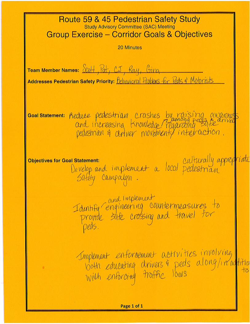
Sandra Jobson facilitated a Goals and Objectives Exercise with the meeting attendees. The exercise included two parts; the first part, SAC members’ brain stormed existing pedestrian safety issues along the corridors, being sure to include ones previously identified during April 2015 walking field assessment. These pedestrian safety issues were recorded on large sheets of paper and displayed at the front of the meeting room. Meeting attendees were then given two stickers, a red sticker and a green sticker. Meeting attendees were asked to place their stickers besides their top two pedestrian safety issues in the corridor. The second part of the group exercise involved identifying the top four critical issues based on the results of the sticker exercise. Four groups were formed using meeting attendees; each group had between 4‐6 people from varying disciplines. Each group was given an issue and asked to create a goal statement based on their issue and develop a list of supporting objectives. Group exercise directions and results are attached.
• Next Steps
Sandra Jobson provide VHB with NYSDOT ADA data Sandra Jobson reserve Finkelstein Memorial Library meeting room for the first public workshop – December 1st
Sandra Jobson schedule next SAC meeting 1 – 2 weeks prior to the first public workshop
SAC submit stakeholder contact information to Sandra Jobson Rockland County provide demographics for study area VHB provide short summary of data findings for next SAC meeting VHB analyze data and look for crash/cause of high crash locations for next SAC meeting
VHB collect additional data based on pattern recognition for next SAC meeting


New York State Department of Transportation
Routes 59 & 45 Pedestrian Safety Study Village of Spring Valley & Town of Ramapo, Rockland County
Study Flow Chart Including Public Involvement Activities
Elected officials notification—share study objectives and overall approach to be taken by the NYS Department of Transportation to successfully complete the pedestrian safety study
Pedestrian Safety Study—Existing Conditions & Field Audits STEP I
Conduct technical analysis & data collection of existing conditions, including gathering rele-vant data collected by others. Perform pedestrian focused road safety audits at select study
locations.
Meet w/Pedestrian Safety Study Advisory Committee (SAC)–introduce study to the SAC, share results of tech-nical analysis & data collection. Confirm prioritized pedestrian safety locations based on crash data. Deter-
mine locations for safety audits. Prepare for Public Workshop I (anticipate 1 mtg.)
Public Workshop I—Provide stakeholders with objectives of the study and overall approach including public involvement process. Share results of technical analysis, data collection & field audits. Gather
stakeholder input.
Pedestrian Safety Study—Select Safety Solutions STEP II
Based on information collected during Steps I, develop appropriate recommended safety solu-tions in areas of Engineering, Education and Enforcement. Categorize solutions by simple, moderately complex, and complex. Determine who would be responsible for implementing
and determine rough cost estimates.
Public Workshop II—Provide stakeholders with corridor pedestrian safety study recommendations including associated costs and draft implementation plan. Gather stakeholder input.
Meet w/Pedestrian Safety Study Advisory Committee (SAC)–share results of Public Workshop II. Confirm rec-ommendations and finalize study including implementation plan based on information collected.
(anticipate 1 mtg.)
Meet w/Pedestrian Safety Study Advisory Committee (SAC)–review the results of Step I and Public Workshop I. Review draft safety solutions in the areas of Engineering, Education and Enforcement. Reach consensus on
recommended safety solutions and draft implementation plan (anticipate 1 mtg.)
Pedestrian Safety Study—Issue Final Study Recommendations & Implementation Plan STEP III
Finalize and issue study recommendations and implementation plan based on SAC and stake-holder input; complexities of safety solutions; and associated costs.
Sept 2015
Dec 2015
Meet w/Pedestrian Safety Study Advisory Committee (SAC)–conduct pedestrian focused road safety audits. (anticipate 1-2 days)
Oct 2015
Dec-Jan 2015
Jan 2015
Nov 2015
Dec 2015
Jan 2015
Jan 2015
Sept—Oct 2015
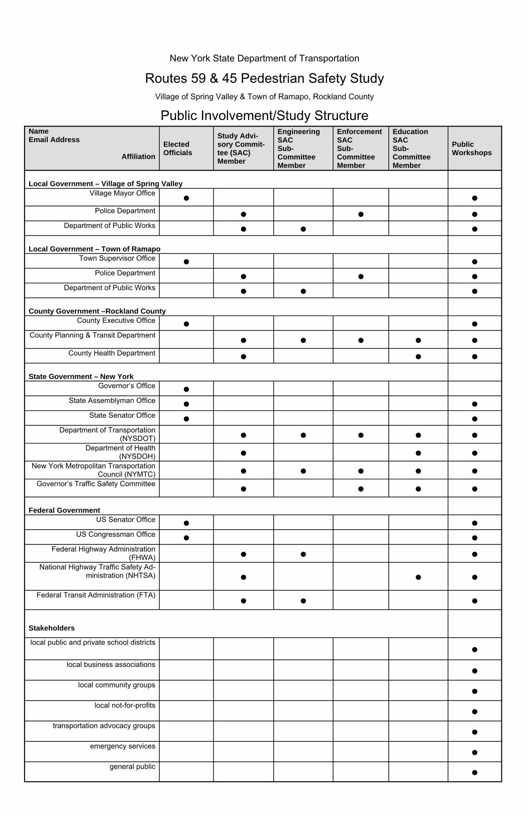
Name Email Address
Affiliation
Elected Officials
Study Advi-sory Commit-tee (SAC) Member
Engineering SAC Sub-Committee Member
Enforcement SAC Sub-Committee Member
Education SAC Sub-Committee Member
Public Workshops
Local Government – Village of Spring Valley
Village Mayor Office ● ●
Police Department ● ● ● Department of Public Works ● ● ●
Local Government – Town of Ramapo
Town Supervisor Office ● ● Police Department ● ● ●
Department of Public Works ● ● ● County Government –Rockland County
County Executive Office ● ● County Planning & Transit Department ● ● ● ● ●
County Health Department ● ● ● State Government – New York
Governor’s Office ● State Assemblyman Office ● ●
State Senator Office ● ● Department of Transportation
(NYSDOT) ● ● ● ● ●
Department of Health (NYSDOH) ● ● ●
New York Metropolitan Transportation Council (NYMTC) ● ● ● ● ●
Governor’s Traffic Safety Committee ● ● ● ●
Federal Government
US Senator Office ● ● US Congressman Office ● ●
Federal Highway Administration (FHWA) ● ● ●
National Highway Traffic Safety Ad-ministration (NHTSA) ● ● ●
Stakeholders
TBD (local school districts) ●
TBD (local business associations) ●
TBD (local community groups) ●
TBD (local not-for-profits) ●
TBD (transportation advocacy groups) ●
TBD (emergency services) ●
General Public ●
New York State Department of Transportation
Routes 59 & 45 Pedestrian Safety Study Village of Spring Valley & Town of Ramapo, Rockland County
Public Involvement/Study Structure
Page 1 of 1
USDOT, Walking Safety Assessment, performed April 16, 2015 Summary of Assessment Results prepared by NYSDOT for purposes of Route 59 & 45 Pedestrian Safety Study
Route 59 Route 45 Issues
Infrastructure • Missing sidewalks • Outdated and non ADA compliant
sidewalk system • Too few marked crosswalks • Missing crosswalks • Poor condition of transit stops • Non‐functioning pedestrian signals • Pedestrian signals inoperable/broken
User Behavior • Pedestrians crossing anywhere • Pedestrians failing to follow rules • Cyclists traveling wrong side of road
• Vehicles speeding • Vehicles failing to yield to pedestrians
RecommendationsEngineering
• Install complete sidewalk system • Repair sidewalks and make ADA compliant • Install more crosswalks • Repaint and install more crosswalks • Install raised median to decrease crossing
distance and provide refuge area
• Reduce speed limit • Repair pedestrian signals • Install improved lighting • Proper nighttime lighting • Install mid‐block crossings • Add mid‐block crossings where needed • Repair/Improve transit stop • Improve pedestrian safety/circulation at
transit stop • Update traffic signal equipment • Update traffic signal equipment • Reduce commercial driveway entrance
openings
• Consolidate/eliminate driveways • Transit – Pedestrian OD study
Enforcement • Strengthen/expand existing pedestrian
safety decoy program
• Address pedestrian error/jaywalking • Issue citations to
motorist/pedestrians/cyclists
Education • Establish localized pedestrian safety media
campaign • Pedestrian safety campaign, multiple
languages
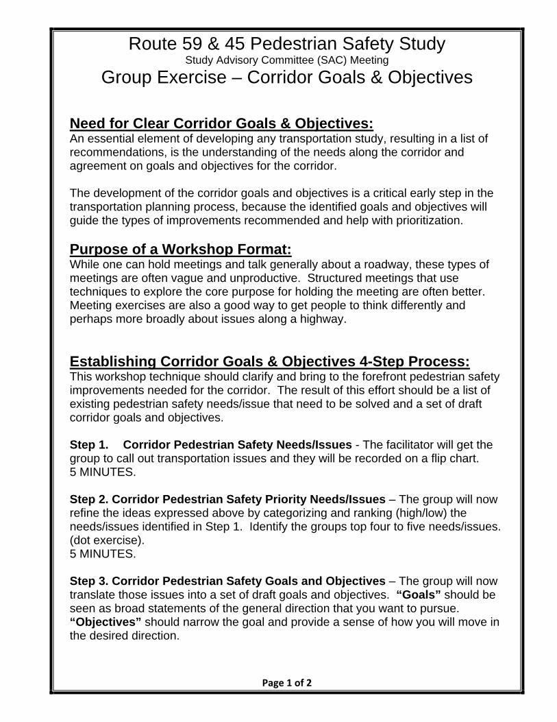
Route 59 & 45 Pedestrian Safety Study Study Advisory Committee (SAC) Meeting
Group Exercise – Corridor Goals & Objectives
Page 1 of 2
Need for Clear Corridor Goals & Objectives: An essential element of developing any transportation study, resulting in a list of recommendations, is the understanding of the needs along the corridor and agreement on goals and objectives for the corridor. The development of the corridor goals and objectives is a critical early step in the transportation planning process, because the identified goals and objectives will guide the types of improvements recommended and help with prioritization.
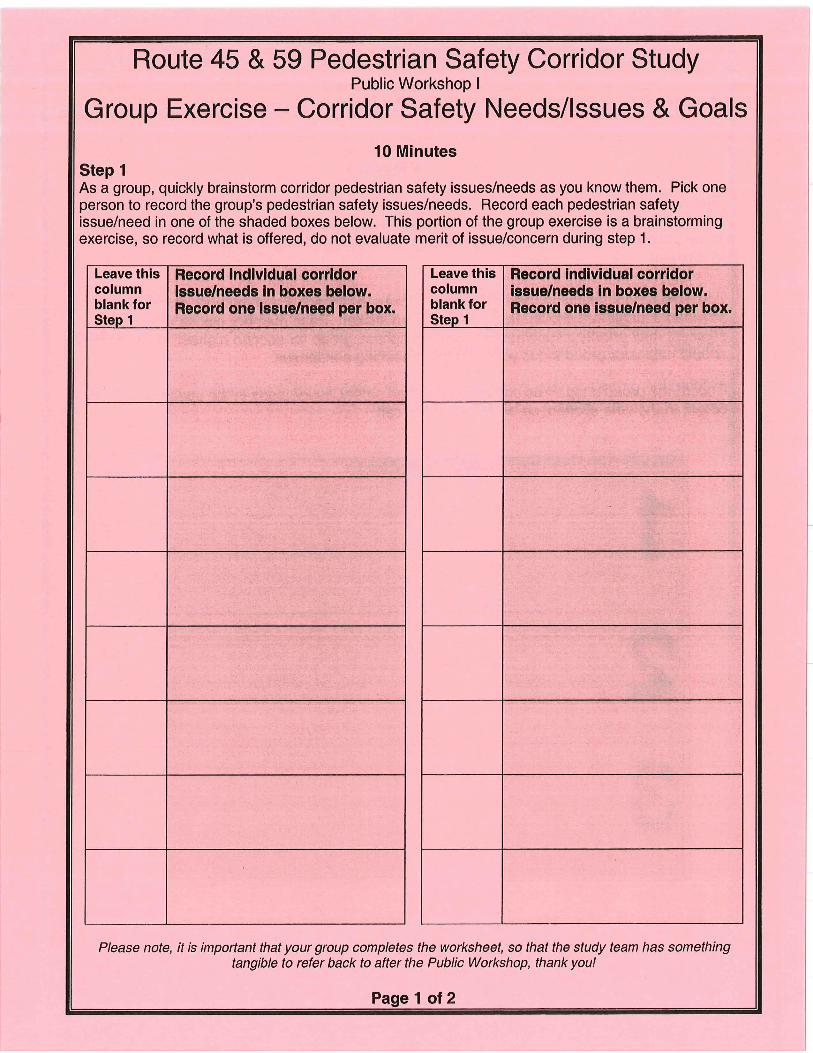
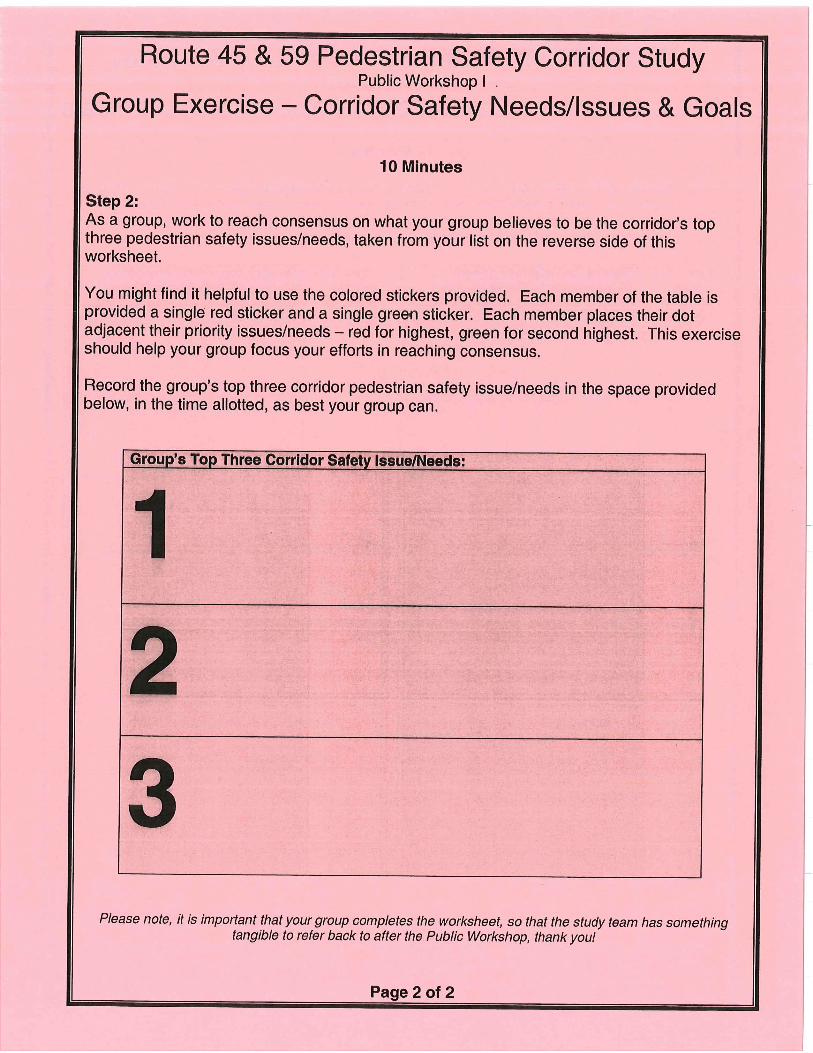
Purpose of a Workshop Format: While one can hold meetings and talk generally about a roadway, these types of meetings are often vague and unproductive. Structured meetings that use techniques to explore the core purpose for holding the meeting are often better. Meeting exercises are also a good way to get people to think differently and perhaps more broadly about issues along a highway. Establishing Corridor Goals & Objectives 4-Step Process: This workshop technique should clarify and bring to the forefront pedestrian safety improvements needed for the corridor. The result of this effort should be a list of existing pedestrian safety needs/issue that need to be solved and a set of draft corridor goals and objectives. Step 1. Corridor Pedestrian Safety Needs/Issues - The facilitator will get the group to call out transportation issues and they will be recorded on a flip chart. 5 MINUTES. Step 2. Corridor Pedestrian Safety Priority Needs/Issues – The group will now refine the ideas expressed above by categorizing and ranking (high/low) the needs/issues identified in Step 1. Identify the groups top four to five needs/issues. (dot exercise). 5 MINUTES. Step 3. Corridor Pedestrian Safety Goals and Objectives – The group will now translate those issues into a set of draft goals and objectives. “Goals” should be seen as broad statements of the general direction that you want to pursue. “Objectives” should narrow the goal and provide a sense of how you will move in the desired direction.

Route 59 & 45 Pedestrian Safety Study Study Advisory Committee (SAC) Meeting
Group Exercise – Corridor Goals & Objectives
Page 2 of 2
Break-up into teams of 4-5, you’ll be given a category from which to work. Use the worksheet titled “Corridor Study Goals and Objectives” to record your groups work. 20 MINUTES! Helpful information on establishing goals & objectives and understanding their relationship to the overall study:
Goals are important because they express a consensus view on where the corridor is headed. Even if people don’t agree on the objective (on how) to reach the goal, they should at least agree on the goal’s intention. Keep the goals specific. Some of the “Corridor Pedestrian Safety Priority Needs/Issues” may easily lend themselves to becoming goal statements. For instance, the issue of “sidewalks missing and not ADA compliant” could be translated to the goal statement “Provide an interconnected system of sidewalks, ADA compliant, which provide safe movement of pedestrians”. The goal then would need supporting objectives of how this goal might be accomplished in the corridor. An example objective for the goal statement above might be “construct new ADA compliant sidewalks within the corridor where sidewalks are missing” and “reconstruct existing sidewalk system to be ADA compliant”. The study will then seek and recommend solutions for implementation, based upon the overriding corridor goals and objectives.
Once the group has a set of “Goal and Objective Statements,” go back to your “Priority Needs/Issue” and check to be sure that you have addressed your assigned priority issue. Step 4. Report Back – Each group will provide its draft goal statement and supporting objective(s). 10 MINUTES!
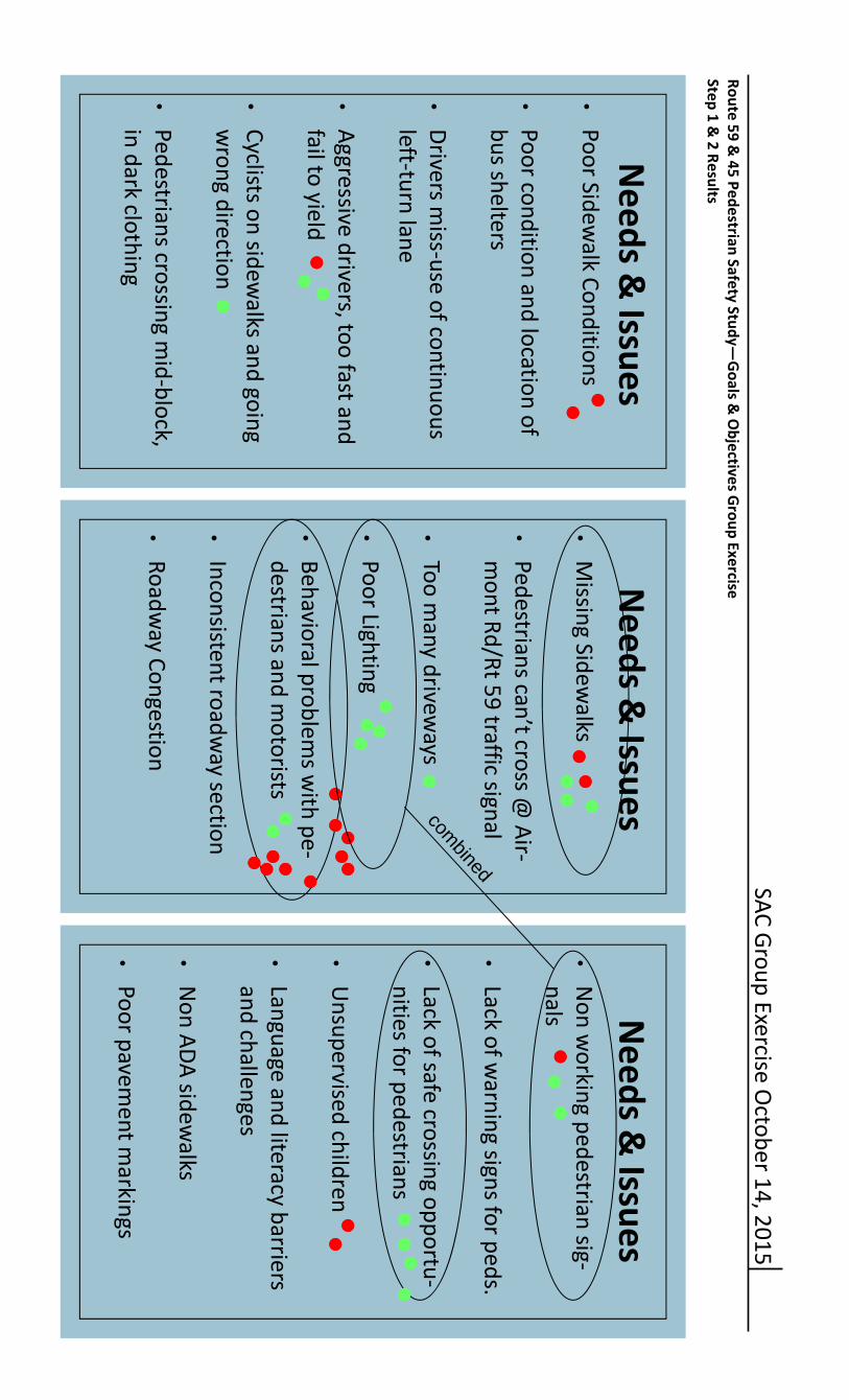
SAC Group Exercise O
ctober 14, 2015
Route 59 & 45 Pedestrian Safety Study—
Goals &
Objectives G
roup Exercise Step 1 &
2 Results
Needs &
Issues • Poor Sidew
alk Conditions • Poor condition and location of bus shelters
• Drivers m
iss‐use of continuous left‐turn lane
• Aggressive drivers, too fast and fail to yield
• Cyclists on sidew
alks and going wrong direction
• Pedestrians crossing m
id‐block, in dark clothing
Needs &
Issues • Missing Sidew
alks • Pedestrians can’t cross @
Air‐mont Rd/Rt 59 traffic signal
• Too m
any driveways
• Poor Lighting
• Behavioral problem
s with pe‐
destrians and motorists
• Inconsistent roadw
ay section • Roadw
ay Congestion
Needs &
Issues • Non w
orking pedestrian sig‐nals
• Lack of w
arning signs for peds. • Lack of safe crossing opportu‐nities for pedestrians
• Unsupervised children
• Language and literacy barriers and challenges
• Non ADA sidew
alks • Poor pavem
ent markings
combined


Summary of U
SDOT W
alking Safety Assessment (April 2015) and N
YSDOT Route 59 &
45 Pedestrian Safety Study SAC Meeting #1 (O
ctober 2015)
Route 59Route 45
IssuesInfrastructure
USD
OT
Walking Assessm
ent NYSD
OT
SAC Meeting #1
USD
OT
Walking Assessm
ent NYSD
OT
SAC Meeting #1
• Missing sidew
alks •
Poor sidewalk conditions, N
on‐ ADA com
pliant & M
issing Sidewalks
• Outdated and non ADA com
pliant sidew
alk system
• Poor sidew
alk conditions, Non‐ ADA
compliant &
Missing Sidew
alks •
Too few m
arked crosswalks
• Lack of safe crossing opportunities for pedestrians
• Missing crossw
alks Lack of safe crossing opportunities for pedestrians
•
Lack of pedestrian warning signs to
motorists
Lack of pedestrian w
arning signs to motorists
• Poor condition of transit stops
• Poor condition and location of bus stops
• Non‐functioning pedestrian signals
• Non w
orking pedestrian signals •
Pedestrian signals inoperable/broken •
Non w
orking pedestrian signals
• Too m
any driveways
•
Poor nighttime lighting
•
Poor nighttime lighting
•
Inconsistent roadway section
•
Roadway congestion
•
Roadway congestion
•
Poor pavement m
arkings
• Poor pavem
ent markings
User Behavior
USD
OT
Walking Assessm
ent NYSD
OT
SAC Meeting
USD
OT
Walking Assessm
ent NYSD
OT
SAC Meeting
•
Behavioral problems w
ith pedestrians and m
otorists
• Behavioral problem
s with pedestrians
and motorists
• Pedestrians crossing anyw
here •
Pedestrians crossing mid‐block in dark
clothing •
Pedestrians failing to follow rules
• Pedestrians crossing m
id‐block in dark clothing
•
Unsupervised children
•
Unsupervised children
• Cyclists traveling w
rong side of road •
Cyclists traveling wrong w
ay and on sidew
alks
• Cyclists traveling w
rong way and on
sidewalks
•
Aggressive drivers, too fast •
Vehicles speeding •
Aggressive drivers, too fast
• Aggressive drivers, fail to yield
• Vehicles failing to yield to pedestrians
• Aggressive drivers, fail to yield
•
Driver’s miss‐use of continuous left‐turn
lane
•
Language and literacy barriers and challenges
•
Language and literacy barriers and challenges

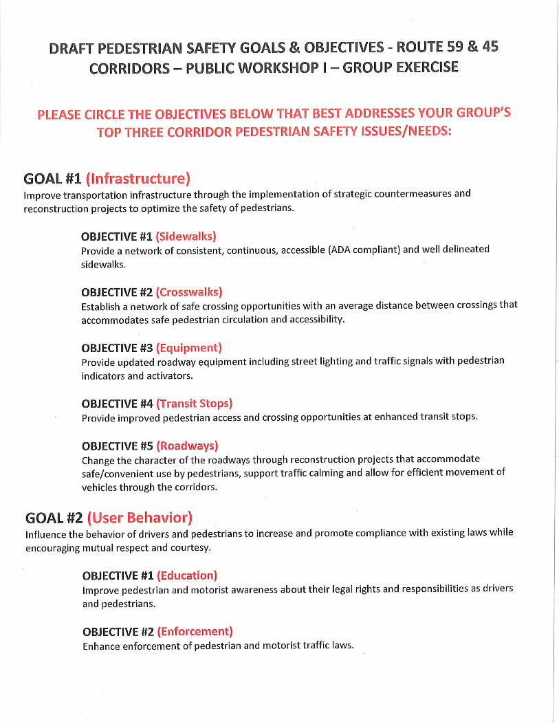
DRAFT PED
ESTRIAN SAFETY G
OALS &
OBJECTIVES
ROUTE 59 &
45 CORRID
ORS
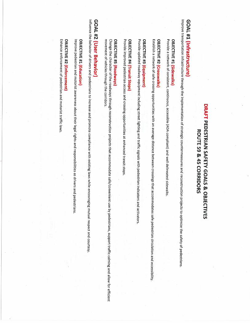
GOAL #1 (Infrastructure)
Improve transportation infrastructure through the im
plementation of strategic counterm
easures and reconstruction projects to optimize the safety of pedestrians.
OBJECTIVE #1 (Sidew
alks) Provide a netw
ork of consistent, continuous, accessible (ADA compliant) and w
ell delineated sidewalks.
OBJECTIVE #2 (Crossw
alks) Establish a netw
ork of safe crossing opportunities with an average distance betw
een crossings that accommodates safe pedestrian circulation and accessibility.
OBJECTIVE #3 (Equipm
ent) Provide updated roadw
ay equipment including street lighting and traffic signals w
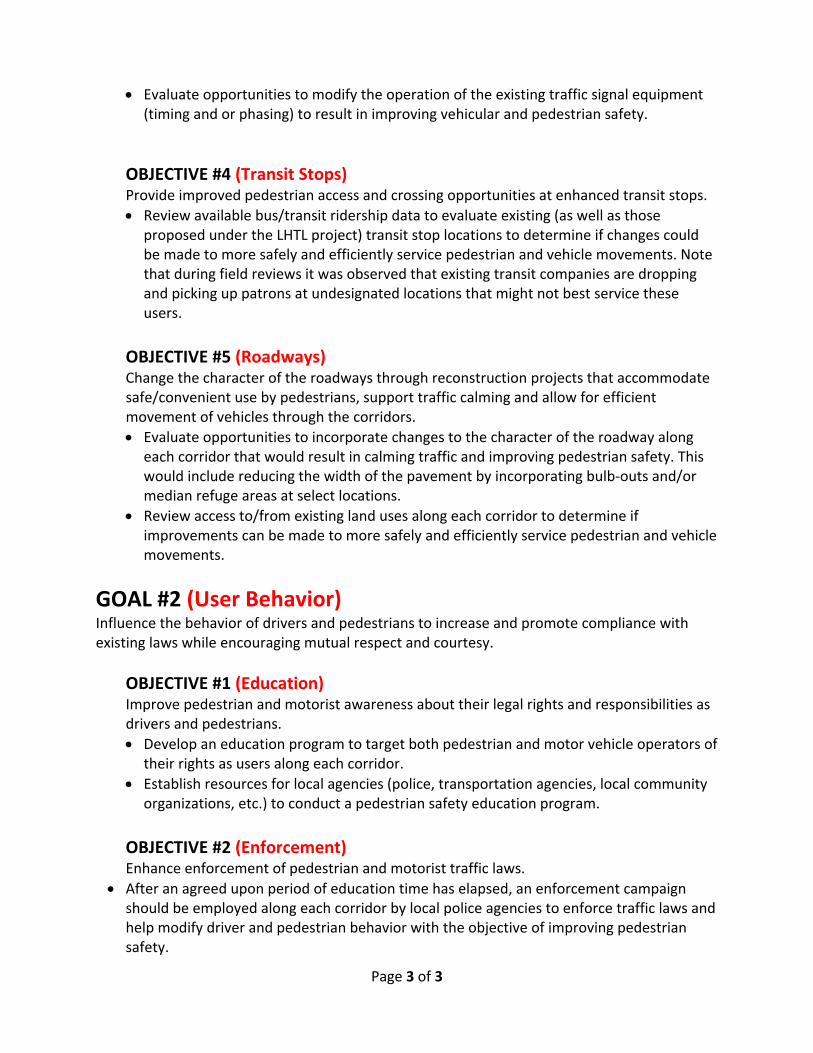
ith pedestrian indicators and activators. OBJECTIVE #4 (Transit Stops)
Provide improved pedestrian access and crossing opportunities at enhanced transit stops.
OBJECTIVE #5 (Roadw
ays) Change the character of the roadw
ays through reconstruction projects that accommodate safe/convenient use by pedestrians, support traffic calm
ing and allow for efficient
movem
ent of vehicles through the corridors. GOAL #2 (U
ser Behavior) Influence the behavior of drivers and pedestrians to increase and prom
ote compliance w
ith existing laws w
hile encouraging mutual respect and courtesy.
OBJECTIVE #1 (Education)
Improve pedestrian and m
otorist awareness about their legal rights and responsibilities as drivers and pedestrians.
OBJECTIVE #2 (Enforcem
ent) Enhance enforcem
ent of pedestrian and motorist traffic law
s.

SAC Meeting 2

Meeting Notes
Route 59 & 45 Pedestrian Safety Study Study Advisory Committee (SAC) Meeting #2
Date: November 19, 2015
Time: 1:30pm – 2:30pm
Place: Town of Ramapo, Town Hall
• Welcome and Introductions
Sandra Jobson, from NYSDOT, welcomed the Study Advisory Committee (SAC) to the second meeting. The attached agenda was distributed. Each attendee stated their name and company/organization. The committee was represented by federal, state, county and local governments, town officials, law enforcement, health, and transportation consulting team. See attached copy of attendance sign‐in sheet.
• Overview of Data Collection
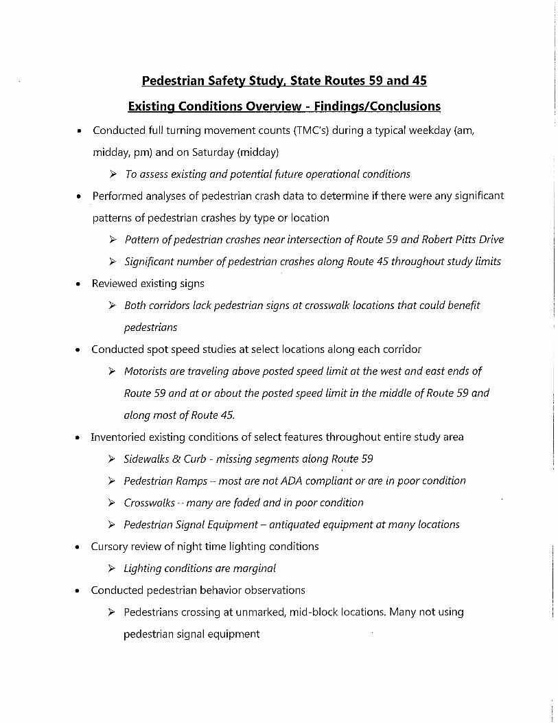
Scott Spittal, from VHB, explained the data collected and summarized to date. Turning Movement Counts (TMC’s), pedestrian counts, pedestrian behavior observations and spot speed studies were conducted on Wednesday, November 4th and Saturday, November 7th. Turning Movement Counts (TMC’s) and pedestrian counts, using Miovision technology, at 12 intersections along Route 59 and 9 intersections along Route 45 were collected. Scott described a typical Miovision setup which usually has 2 video cameras mounted on poles at each intersection. The cameras collect vehicle and pedestrian data 24 hours a day for a specified period. This data is processed to extract the data by class i.e. autos, trucks, buses, pedestrians and by time of day i.e. weekday (am, midday, pm) and Saturday (midday). People were assigned to the field to observe pedestrian behavior and perform spot speed studies at select locations along each corridor.
A GIS smart phone app, along with the video field audit, was used to locate, inventory and perform a condition assessment of the existing pedestrian related assets throughout the study area. These assets included: sidewalks, pedestrian ramps, crosswalks and traffic and pedestrian signal equipment. VHB conducted a field visit on Monday, November 9th and Wednesday, November 11th to confirm locations and access the condition of the assets in the study area. The data was updated in the field using smart phones and tablets.
• Review of Draft Goals & Objectives
Sandra Jobson distributed draft goals and objectives derived from the needs identified during the USDOT Walking Safety Assessment (April 2015) and the Routes 59 & 45 Pedestrian Safety Study SAC Meeting #1 (October 2015). Sandra explained how the draft goals and objectives were developed, offered the SAC members to review and provide any feedback either during the meeting or after the meeting. Sandra explained the draft goals and objectives would be shared with the public for review and commenting during Public Workshop I. Draft goals and objectives attached.
• Prep for Public Workshop I
Sandra Jobson spoke about the public workshop which is to be held at the Finkelstein Memorial Library on December 1st. Sandra Jobson is looking for a well‐attended public workshop. The workshop will be announced through: a press release, emails, and direct mailings. Sandra asked for volunteers to help welcome attendees and facilitate tables for the group exercise. Shannon Purdy, from NHTSA, volunteered to help welcome attendees, and VHB will help facilitate the tables.
The public announcement, advertising the workshop, will be translated into Spanish, Yiddish and French Creole. Sandra Forte, from VHB, collected contact information for translators. She will also reach out to see if translators can act as interpreters at the workshop.
• Next Steps
Prepare for Public Workshop I on December 1st.
Next SAC meeting is scheduled for December 17th.
The following were discussion points:
o A few questions were raised about the Miovision technology: How many cameras were used?, Would the video be available to the SAC?, and Can a specific time be entered to view the Miovision video?. In response to these questions, another question came about, What data are you hoping to get by viewing the video? The grainy quality of the video makes it hard to view. Therefore algorithms are used to extract the data.
o Scott Spittal noted after reviewing the data and performing a technical analysis, supplemental data could be collected to support the findings. Sandra Jobson commented: the data collection effort is a good way to communicate the reasoning behind the recommendations, support goals and objectives, prioritize
recommendations based on a short, medium and long term implementation strategy, get a “buy in” from the community and secure funding.
o The SAC inquired if the asset data, collected through the GIS smart phone, would be available to responsible parties of the village, town and state. They would like to add comments to the findings. Scott responded, this could be shared, but sharing permission and limitations would have to be in place to prevent compromising the existing data.
o Were the study area corridors part of a priority investigation location (PIL)? About 2 years ago, a PIL study was performed on Route 45. This is the reason these corridors were selected as the focus of this study.
• Action Items Sandra Forte, from VHB, will reach out and contact recommended Spanish, Yiddish and French Creole translators.
Officer Omar Olayan, from the Town of Ramapo, will write a brief report on the string operation being done to promote pedestrian and vehicle safety through education and enforcement. It will include how long the operation has been in place, when the enforcement starts to go in effect, is it working?...
Gina Gillodey, from the NYS Department of Health, will bring educational material to December 1st public workshop meeting.


AGENDA
Route 59 & 45 Pedestrian Safety Study Study Advisory Committee (SAC) Meeting #2
Ramapo Town Hall 237 Route 59, Suffern, New York
Thursday, November 19, 2015 1:30 PM to 2:30 PM
• Welcome and Introductions 5 minutes Sandra Jobson, RA, RLA, AICP, NYSDOT 1:30 – 1:35 PM
• Overview of Data Collection 20 minutes Scott Spittal, PE, VHB 1:35 – 1:55 PM
• Review of Draft Goals & Objectives Sandra Jobson, RA, RLA, AICP, NYSDOT 20 minutes 1:55 – 2:15 PM
• Prep for Public Workshop I 10 minutes Sandra Jobson, RA, RLA, AICP, NYSDOT 2:15 – 2:25 PM
• Next Steps 5 minutes Sandra Jobson, RA, RLA, AICP, NYSDOT 2:25 – 3:00 PM

Summary of U
SDOT W
alking Safety Assessment (April 2015) and N
YSDOT Route 59 &
45 Pedestrian Safety Study SAC Meeting #1 (O
ctober 2015)
Route 59Route 45
IssuesInfrastructure
USD
OT
Walking Assessm
ent NYSD
OT
SAC Meeting #1
USD
OT
Walking Assessm
ent NYSD
OT
SAC Meeting #1
• Missing sidew
alks •
Poor sidewalk conditions, N
on‐ ADA com
pliant & M
issing Sidewalks
• Outdated and non ADA com
pliant sidew
alk system
• Poor sidew
alk conditions, Non‐ ADA
compliant &
Missing Sidew
alks •
Too few m
arked crosswalks
• Lack of safe crossing opportunities for pedestrians
• Missing crossw
alks Lack of safe crossing opportunities for pedestrians
•
Lack of pedestrian warning signs to
motorists
Lack of pedestrian w
arning signs to motorists
• Poor condition of transit stops
• Poor condition and location of bus stops
• Non‐functioning pedestrian signals
• Non w
orking pedestrian signals •
Pedestrian signals inoperable/broken •
Non w
orking pedestrian signals
• Too m
any driveways
•
Poor nighttime lighting
•
Poor nighttime lighting
•
Inconsistent roadway section
•
Roadway congestion
•
Roadway congestion
•
Poor pavement m
arkings
• Poor pavem
ent markings
User Behavior
USD
OT
Walking Assessm
ent NYSD
OT
SAC Meeting
USD
OT
Walking Assessm
ent NYSD
OT
SAC Meeting
•
Behavioral problems w
ith pedestrians and m
otorists
• Behavioral problem
s with pedestrians
and motorists
• Pedestrians crossing anyw
here •
Pedestrians crossing mid‐block in dark
clothing •
Pedestrians failing to follow rules
• Pedestrians crossing m
id‐block in dark clothing
•
Unsupervised children
•
Unsupervised children
• Cyclists traveling w
rong side of road •
Cyclists traveling wrong w
ay and on sidew
alks
• Cyclists traveling w
rong way and on
sidewalks
•
Aggressive drivers, too fast •
Vehicles speeding •
Aggressive drivers, too fast
• Aggressive drivers, fail to yield
• Vehicles failing to yield to pedestrians
• Aggressive drivers, fail to yield
•
Driver’s miss‐use of continuous left‐turn
lane
•
Language and literacy barriers and challenges
•
Language and literacy barriers and challenges

DRAFT PED
ESTRIAN SAFETY G
OALS &
OBJECTIVES
ROUTE 59 &
45 CORRID
ORS
GOAL #1 (Infrastructure)
Improve transportation infrastructure through the im
plementation of strategic counterm
easures and reconstruction projects to optimize the safety of pedestrians.
OBJECTIVE #1 (Sidew
alks) Provide a netw
ork of consistent, continuous, accessible (ADA compliant) and w
ell delineated sidewalks.
OBJECTIVE #2 (Crossw
alks) Establish a netw
ork of safe crossing opportunities with an average distance betw
een crossings that accommodates safe pedestrian circulation and accessibility.
OBJECTIVE #3 (Equipm
ent) Provide updated roadw
ay equipment including street lighting and traffic signals w
ith pedestrian indicators and activators. OBJECTIVE #4 (Transit Stops)
Provide improved pedestrian access and crossing opportunities at enhanced transit stops.
OBJECTIVE #5 (Roadw
ays) Change the character of the roadw
ays through reconstruction projects that accommodate safe/convenient use by pedestrians, support traffic calm
ing and allow for efficient
movem
ent of vehicles through the corridors. GOAL #2 (U
ser Behavior) Influence the behavior of drivers and pedestrians to increase and prom
ote compliance w
ith existing laws w
hile encouraging mutual respect and courtesy.
OBJECTIVE #1 (Education)
Improve pedestrian and m
otorist awareness about their legal rights and responsibilities as drivers and pedestrians.
OBJECTIVE #2 (Enforcem
ent) Enhance enforcem
ent of pedestrian and motorist traffic law
s.

SAC Meeting 3

Page 1 of 6
Meeting Notes
Route 59 & 45 Pedestrian Safety Study Study Advisory Committee (SAC) Meeting #3
Date: December 17, 2015
Time: 10:00am – 11:00am
Where: Louis Kurtz Civic Center, Village of Spring Valley
• Welcome and Introductions
Sandra Jobson, from NYSDOT, welcomed the Study Advisory Committee (SAC) to the third meeting. The attached agenda was distributed. Each attendee stated their name and company/organization affiliation. The committee was represented by federal, state, county and local governments, law enforcement, health, and the transportation consulting team. See attached copy of attendance sign‐in sheet.
• Review of Public Workshop I Results
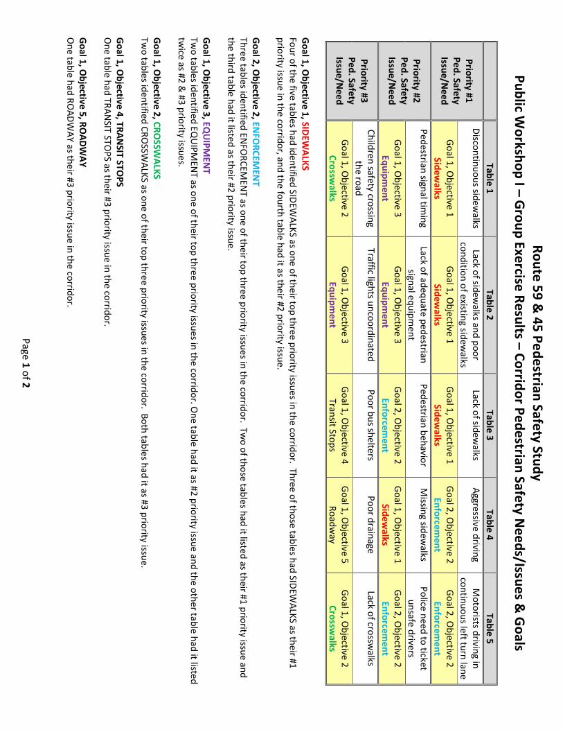
Sandra Jobson spoke about the public workshop #1 which was held at the Finkelstein Memorial Library on December 1st, 2015. It involved an exercise where the public and members from SAC were asked to form groups and list issues in the study area concerning pedestrian safety. The groups were then asked to pick their top 3 priority issues and compare them with the draft goals & objectives developed from SAC Meeting #1. Sandra was happy to report that the objectives stated by the groups fall in‐line with what the SAC had initially identified. The issues ranked in priority order as follows: sidewalks, enforcement, equipment, crosswalks, transit stops and roadway. Sandra distributed a summary sheet of Public workshop #1 results; summary sheet attached.
• Finalize Goals & Objectives
Sandra asked if everyone was comfortable changing “draft” to “final” when referring to the goals and objectives handout. Everyone at the meeting was in agreement. She noted we can still come back to the “final” goals and objectives once everyone has had a chance to review and discuss back at their offices, but otherwise the goals & objectives were considered final.
• Review of Draft Recommendations
Sandra said that currently the recommendations are very broad based, and we would like to get more specific. She asked the SAC committee to brainstorm and offer any “best practices” of past initiatives that worked including logical partners.

Page 2 of 6
Goal #1 Infrastructure
Objective #1 – Sidewalks
The construction of new sidewalks and ramps will provide a continuous network along each corridor. The reconstruction of non‐ADA compliant sidewalks and ramps will be brought up to ADA standards. VHB looked at right‐of‐way (ROW) information and also noted that in conjunction with adding new sidewalks, there are opportunities to improve access at numerous sites.
Objective #2 – Crosswalks
Scott mentioned Route 59 does not have a lot of existing crosswalks and the current roadway geometry (width) needs to be considered when contemplating new crosswalk locations. He asked the SAC if missing crosswalks at intersections without traffic control or mid‐block crossings should be included in the cost estimate. Sandra said to add missing crosswalks at all intersections and at areas where a mid‐block crossing could service crossing opportunities along the corridor. The crosswalks signal motorists to use caution because they have entered an area with high pedestrian traffic. A more detailed project will determine if a crosswalk is warranted/appropriate. Scott mentioned VHB included new crosswalks where none existed to provide a conservative estimate.
Objective #3 – Equipment
Lighting: In general, the intersections, sidewalks and corridors, in the study area, are not well lit. For example, improvement of street lighting is necessary at crosswalks either using luminaires or standalones at crosswalks. In addition, it was mentioned that pedestrian level lighting should be considered to better light the sidewalk areas. If not, there is a concern that pedestrians wearing dark clothing at night may walk in the street as opposed to using an unlit sidewalk for safety reasons. VHB will vet lighting requirements with NYSDOT best practices.
Pedestrian Control: In general, most of the pedestrian signal equipment is outdated. The region was contacted about best practices regarding re‐building or replacing equipment. It was agreed that at locations where the pedestrian signal equipment is not adequate, the signals would be completely rebuilt.
Traffic Control: Turning movement counts were collected at 25 intersections in the study area. VHB will use this data to develop a Synchro Model to examine the existing traffic flow and signal timing. An alternative model can be used to simulate signal timing adjustments used to progress vehicles through the corridor while encouraging safe driving speeds. It can also be used to evaluate potential changes to the signal operations such as incorporating leading pedestrian intervals, exclusive pedestrian phases, adjustments to pedestrian signal timing for safe crossing, etc.

Page 3 of 6
Objective #4 – Transit Stops: The implementation plan will include the need to review the ADA compliancy of existing transit stops. During the field study, it was observed that buses were stopping at unmarked or “phantom” transit stops. This often led to pedestrians crossing at midblock or at unmarked crosswalks at the drop‐off locations. VHB will review the Lower Hudson Transit Link (LHTL) findings and contact Kathleen Porter at the Rockland County Department of Planning & Public Transportation to get specific information about the bus routes and bus stops in the study area. It was stated that a “flag down” system of signaling buses for pick up is allowed in Rockland County.
Objective #5 – Roadways
Route 45 has adequate geometry and vehicular speeds are closer to the posted limit. It needs updated pedestrian control equipment, behavior and education.
Review on‐street parking along Route 45. A question was raised about the required distance between parked vehicles and intersection crosswalks because of limited pedestrian visibility. Possible solutions were: restrict parking near intersections, construct longer bump outs, utilize and improve directional signage to municipal parking lots.
The middle section of Route 59 is a narrower road which helps to calm traffic. Route 59 has higher vehicle speeds on the east and west ends because of wide lanes, wide shoulders and a center turning lane. Conceptual ideas are needed for the east and west ends of Route 59 that considers a narrower roadway and inhibit speeding. Operational ideas will have to be vetted with the region.
Goal #2 User Behavior
Objective #1 – Education
Shannon Purdy will coordinate phone call on enforcement and education. Scott Spittal and Sandra Jobson will participate on the call. The SAC thought Omar Olayan, from the Ramapo Police Department, and C.J. Schnaars, from the Spring Valley Police Department, should be invited on the call. Sandra and the SAC believe the police department’s input and participation will make it easier for them to buy into the user behavior goal and objectives recommendations.
Objective #2 ‐ Enforcement
Dominick G. Macherone, from the NYS Association of Chiefs of Police, Inc., suggested a two day training course for law enforcement. This is covered by grants based on state‐wide data. Currently the following counties have had the course: Nassau, Niagara, Erie, Westchester, Onondaga and Suffolk (canceled, must be re‐scheduled). The course is taught by a consultant. Omar Olayan attended the course in Westchester County.
Bob Dennison, from VHB, suggested having an Aggressive Driving Campaign in the study area. This would be similar to the annual, June campaign that takes place for one week on Route 9 in Poughkeepsie, Dutchess County. Motorists are given advanced warning about the targeted
Page 4 of 6
enforcement, but approximately 2,000 tickets are given out. Bob thought we may want to consider the campaign during the school year because more school children and care givers are out walking. It could be a good education opportunity for motorists and pedestrians.
The following are recommendations from the SAC roundtable discussion:
RECOMMENDATION #1: On‐street parking on Route 45 should be moved away from intersections to increase pedestrian visibility.
Most pedestrian crashes occurred when vehicles made left turns and pedestrians crossed mid‐block.
On‐street parking has the effect of motorists driving at lower speeds.
RECOMMENDATION #2: Propose new crosswalks at all intersection legs throughout study area.
At the intersection with Robert Pitt Drive, crosswalks should be considered on all four legs.
Route 59 has a dense pedestrian population because of demographics, so additional, safe pedestrian crossings should be considered.
Does additional crosswalks require an ordinance? No, just a NYSDOT order to enforce.
RECOMMENDATION #3: Pedestrian Control
a) Add directional arrows on pedestrian instructions. New traffic/pedestrian control equipment will provide this feature.
b) Reach diverse population for instruction signs – will be important to communicate. Possibly use universal symbols. Which demographics are using the facilities? Yiddish, Spanish, French Creole and
French. Can we translate the instructions on pedestrian signage in these other
languages? c) It may be possible to have the activation of the pedestrian signals automatically
programmed during the Sabbath. Pedestrian signals will have to be re‐programmed every year because of the leap
year. Who would be responsible for maintenance? Will it have a big impact on vehicles? Possibly not because there are no vehicles
during sundown, just pedestrians. Initiate a pilot program to see changes in pedestrian phase timings on traffic.
d) Add in‐road signage to warn vehicles at pedestrian crossings, i.e. in‐road pedestrian signage on Route 45, warning signs on Route 59
Who is responsible for removing in road signs at night, bad weather? The State is responsible for road maintenance, installing sidewalks and providing
the capital investment for lighting. The municipality waters vegetation, maintains sidewalks and upkeeps lighting.

Page 5 of 6
RECOMMENDATION #4: Metro North Railroad Transit Center
Evaluate existing site and operations; consider redesign to improve pedestrian safety and vehicular circulation.
Cleanup intersection at train station, car‐bus‐pedestrian conflicts Improve signage Make pedestrian friendly i.e. safe crossings
RECOMMENDATION #5: Roadway ‐ Route 59 – Design east and west ends of corridor consistent with the middle section for everyone’s use, vehicles, pedestrians and bicycles. Consider a neck down on Route 59 that would better accommodate a new crossing at an uncontrolled locations.
Include changing the geometry i.e. consider need of center turn lane, wide shoulders.
Investigate uniform, slower speed throughout corridor. (use speed feedback devices)
Consider programming signals to control speeds during free‐flow, off‐peak times. Consider “Rest in red” signal operation – place loops in advance of signals and
change signal to green if vehicles traveling within speed limit. Review Monsey’s vision plan called “The Hamlet Center” for the Town of
Ramapo. The comprehensive plan is on the Town of Ramapo’s website.
RECOMMENDATION #6: Enforcement
a) Sandra recommends the “Pedestrian and Bicycle Training for Law Enforcement” 2‐day training course for Rockland County.
b) Consider use of red light cameras for speed enforcement and speed feedback signs to help modify driver behavior.
Police Traffic Services (PTS) grants can be used to pay for training course Need special state legislature for red light cameras. Cannot be federally
funded. Law enforcement must be at the table and engaged because police
priorities change. The SAC agreed that education and enforcement should be a major focus.
User Behavior ‐ Gina and Jenn have formed a network over a 20 year period. They have not only looked at crash data, but also the hospitalization data/costs associated with injuries. The data can be accessed by municipality. Middle‐aged men have suffered the highest injuries. When making a case for funding, use the hospitalization data/costs associated with injuries.
Feedback signs are accurate. They make drivers aware of speed and can ultimately change their behavior.

Page 6 of 6
RECOMMENDATION #7: Funding Develop list of grant opportunities for enforcement and education ex. TAP from
FHWA.
RECOMMENDATION #8: Education What communities need translation?, Should a task force or focus group be
formed?, How to get information out to community? The target demographics in the study area do not attend press events, or read
local papers, or in some cases in Monsey, use the internet. The best way to disseminate information is handing out flyers. It is simple and cost effective.
• Action Items It was targeted that by December 31st, the SAC will submit any additional recommendations including best practices, specific initiatives and outcomes, description, logical partners and costs.
Develop list of funding/grant opportunities for enforcement and education implementation.
VHB will contact Kathleen Porter at the Rockland County Transportation Department to discuss bus operation along Routes 45 and 59.
Eileen Miller, from the Rockland County Transportation Department, will provide the environmental study, which includes the Monsey Study for the Hamlet Center.
Gina Gillodey and Jenn Hogan, from the NYS Department of Health, will provide a write‐up of suggested recommendations for Education & Enforcement.
• Next Steps Shannon Purdy will coordinate a conference call on enforcement and education. Topics will include: site examples for enforcement and education ‐ what are you doing?, Is it working?
Public workshop #2 will be scheduled to receive feedback on recommendations. SAC Meeting #4 will take place in four weeks with a final list of recommendations. A press release will be considered for announcing the results of the final recommendations.


AGENDA
Route 59 & 45 Pedestrian Safety Study Study Advisory Committee (SAC) Meeting #3
Louis Kurtz Civic Center, Multi-Purpose Room 9 North Main Street, Spring Valley, New York
Thursday, December 17, 2015 10:00 AM to 11:00 AM
• Welcome and Introductions 5 minutes Sandra Jobson, RA, RLA, AICP, NYSDOT 10:00 – 10:05 AM
• Review of PW I Results 15 minutes Sandra Jobson, RA, RLA, AICP, NYSDOT 10:05 – 10:20 AM
• Finalize Goals & Objectives 5 minutes Sandra Jobson, RA, RLA, AICP, NYSDOT 10:20 – 10:25 AM
• Review of Draft Recommendations Scott Spittal, PE, VHB 30 minutes Sandra Jobson, RA, RLA, AICP, NYSDOT 10:25 –10:55 AM
• Next Steps 5 minutes Sandra Jobson, RA, RLA, AICP, NYSDOT 10:55 – 11:00 AM
Page 1 of 2
Route 59 & 45 Pedestrian Safety Study
Public Workshop I – G
roup Exercise Results – Corridor Pedestrian Safety Needs/Issues &
Goals
Table 1 Table 2
Table 3 Table 4
Table 5
Priority #1 Ped. Safety Issue/N
eed
Discontinuous sidewalks
Lack of sidewalks and poor
condition of existing sidewalks
Lack of sidewalks
Aggressive driving Motorists driving in
continuous left turn laneGoal 1, O
bjective 1 Sidew
alks Goal 1, O
bjective 1 Sidew
alks Goal 1, O
bjective 1 Sidew
alks Goal 2, O
bjective 2 Enforcem
ent Goal 2, O
bjective 2 Enforcem
ent
Priority #2 Ped. Safety Issue/N
eed
Pedestrian signal timing
Lack of adequate pedestrian signal equipm
ent Pedestrian behavior
Missing sidew
alks Police need to ticket
unsafe drivers Goal 1, O
bjective 3 Equipm
ent Goal 1, O
bjective 3 Equipm
ent Goal 2, O
bjective 2 Enforcem
ent Goal 1, O
bjective 1 Sidew
alks Goal 2, O
bjective 2 Enforcem
ent
Priority #3 Ped. Safety Issue/N
eed
Children safety crossing the road
Traffic lights uncoordinated Poor bus shelters
Poor drainage Lack of crossw
alks
Goal 1, O
bjective 2 Crossw
alks Goal 1, O
bjective 3 Equipm
ent Goal 1, O
bjective 4 Transit Stops
Goal 1, O
bjective 5 Roadw
ay Goal 1, O
bjective 2 Crossw
alks
Goal 1, O
bjective 1, SIDEW
ALKS Four of the five tables had identified SIDEW
ALKS as one of their top three priority issues in the corridor. Three of those tables had SIDEWALKS as their #1
priority issue in the corridor, and the fourth table had it as their #2 priority issue. Goal 2, O
bjective 2, ENFO
RCEMEN
T Three tables identified EN
FORCEM
ENT as one of their top three priority issues in the corridor. Tw
o of those tables had it listed as their #1 priority issue and the third table had it listed as their #2 priority issue. Goal 1, O
bjective 3, EQUIPM
ENT
Two tables identified EQ
UIPM
ENT as one of their top three priority issues in the corridor. O
ne table had it as #2 priority issue and the other table had it listed tw
ice as #2 & #3 priority issues.
Goal 1, O
bjective 2, CROSSW
ALKS Tw
o tables identified CROSSW
ALKS as one of their top three priority issues in the corridor. Both tables had it as #3 priority issue. Goal 1, O
bjective 4, TRANSIT STO
PS One table had TRAN
SIT STOPS as their #3 priority issue in the corridor.
Goal 1, O
bjective 5, ROAD
WAY
One table had RO
ADWAY as their #3 priority issue in the corridor.

Page 2 of 2
Route 59 & 45 Pedestrian Safety Study
Draft G
oals & Objectives
GOAL #1 (Infrastructure)
Improve transportation infrastructure through the im
plementation of strategic counterm
easures and reconstruction projects to optimize the
safety of pedestrians.
OBJECTIVE #1 (Sidew
alks) Provide a netw
ork of consistent, continuous, accessible (ADA compliant) and w
ell delineated sidewalks.
OBJECTIVE #2 (Crossw
alks) Establish a netw
ork of safe crossing opportunities with an average distance betw
een crossings that accommodates safe pedestrian
circulation and accessibility.
OBJECTIVE #3 (Equipm
ent) Provide updated roadw
ay equipment including street lighting and traffic signals w
ith pedestrian indicators and activators. OBJECTIVE #4 (Transit Stops)
Provide improved pedestrian access and crossing opportunities at enhanced transit stops.
OBJECTIVE #5 (Roadw
ays) Change the character of the roadw
ays through reconstruction projects that accommodate safe/convenient use by pedestrians, support
traffic calming and allow
for efficient movem
ent of vehicles through the corridors.
GOAL #2 (U
ser Behavior) Influence the behavior of drivers and pedestrians to increase and prom
ote compliance w
ith existing laws w
hile encouraging mutual respect and
courtesy.
OBJECTIVE #1 (Education)
Improve pedestrian and m
otorist awareness about their legal rights and responsibilities as drivers and pedestrians.
OBJECTIVE #2 (Enforcem
ent) Enhance enforcem
ent of pedestrian and motorist traffic law
s.

Page 1 of 3
PEDESTRIAN SAFETY GOALS, OBJECTIVES & RECOMMENDATIONS
ROUTE 59 & 45 CORRIDORS GOAL #1 (Infrastructure) Improve transportation infrastructure through the implementation of strategic countermeasures and reconstruction projects to optimize the safety of pedestrians.
OBJECTIVE #1 (Sidewalks and Ramps) Provide a network of consistent, continuous, accessible (ADA compliant) and well delineated sidewalks and ramps.
Reconstruct existing sidewalk and ramps where they are determined to be non ADA compliant.
Construct new sidewalk and ramps, where practical and none currently exist, to provide a consistent, continuous and ADA compliant network along each corridor.
Preliminary Estimates –
o Route 59 – Existing sidewalk and ramps to be reconstructed
Approx. 1,000 LF of sidewalk and 95 ramps, Est construction cost $450k – $500k
New sidewalk and ramps to be constructed
Approx. 12,200 LF of new sidewalk and 85 new ramps should to be constructed. Est construction cost $1.1M‐$1.2M
o Route 45 – Existing sidewalk and ramps to be reconstructed
Approx. 6,000 LF of sidewalk and 80 ramps should be reconstructed. Est construction cost $525k‐$575k,
New sidewalk and ramps to be constructed
None
OBJECTIVE #2 (Crosswalks) Establish a network of safe crossing opportunities with an average distance between crossings that accommodates safe pedestrian circulation and accessibility.
Restripe all existing crosswalks that are in fair or poor condition, along each corridor with durable, high visibility pavement marking materials.
Stripe new crosswalks where practical and deemed appropriate to better service pedestrian crossing opportunities along each corridor.

Page 2 of 3
Add appropriate crosswalk signing at key locations. Preliminary Estimates –
o Route 59 – Existing crosswalk to be restriped
Approx. 25 crosswalks should be restriped. Est construction cost $60k ‐ $75k
New crosswalk to be striped
Approx. 25 new crosswalk should be striped Est construction cost $60k ‐ $75k
o Route 45 – Existing crosswalk to be restriped
Approx. 16 crosswalks should be restriped. Est construction cost $30k ‐ $40k
New crosswalk to be striped
Approx. 30 new crosswalk should be striped Est construction cost $60k ‐ $75k
OBJECTIVE #3 (Equipment) Provide updated roadway equipment including street lighting, signing and ADA compliant pedestrian signals.
Street lighting should be installed to improve pedestrian visibility at all crosswalk locations and pedestrian level lighting should be installed along continuous sections of sidewalk to improve pedestrian comfort level along each corridor. Preliminary Estimates –
o Route 59 – Approx. 16 Street lights. Est construction cost $75k‐$100k
o Route 45 – Approx. 20 Street lights. Est construction cost $75k‐$100k
o ?? pedestrian level lights along corridor. Est construction cost $?? TBD
Rebuild existing traffic signals to include updated pedestrian signal equipment. Preliminary Estimates –
o Route 59 – 8 traffic signals. Est construction cost $1.6M
o Route 45 – 6 traffic signals. Est construction cost $1.2M
Review signing along each corridor to determine if new signing should be installed to improve pedestrian safety.
Page 3 of 3
Evaluate opportunities to modify the operation of the existing traffic signal equipment (timing and or phasing) to result in improving vehicular and pedestrian safety.
OBJECTIVE #4 (Transit Stops) Provide improved pedestrian access and crossing opportunities at enhanced transit stops.
Review available bus/transit ridership data to evaluate existing (as well as those proposed under the LHTL project) transit stop locations to determine if changes could be made to more safely and efficiently service pedestrian and vehicle movements. Note that during field reviews it was observed that existing transit companies are dropping and picking up patrons at undesignated locations that might not best service these users.
OBJECTIVE #5 (Roadways) Change the character of the roadways through reconstruction projects that accommodate safe/convenient use by pedestrians, support traffic calming and allow for efficient movement of vehicles through the corridors.
Evaluate opportunities to incorporate changes to the character of the roadway along each corridor that would result in calming traffic and improving pedestrian safety. This would include reducing the width of the pavement by incorporating bulb‐outs and/or median refuge areas at select locations.
Review access to/from existing land uses along each corridor to determine if improvements can be made to more safely and efficiently service pedestrian and vehicle movements.
GOAL #2 (User Behavior) Influence the behavior of drivers and pedestrians to increase and promote compliance with existing laws while encouraging mutual respect and courtesy.
OBJECTIVE #1 (Education) Improve pedestrian and motorist awareness about their legal rights and responsibilities as drivers and pedestrians.
Develop an education program to target both pedestrian and motor vehicle operators of their rights as users along each corridor.
Establish resources for local agencies (police, transportation agencies, local community organizations, etc.) to conduct a pedestrian safety education program.
OBJECTIVE #2 (Enforcement) Enhance enforcement of pedestrian and motorist traffic laws.
After an agreed upon period of education time has elapsed, an enforcement campaign should be employed along each corridor by local police agencies to enforce traffic laws and help modify driver and pedestrian behavior with the objective of improving pedestrian safety.

SAC Meeting 4

Page 1 of 4
Meeting Notes
Route 59 & 45 Pedestrian Safety Study Study Advisory Committee (SAC) Meeting #4
Date: January 26, 2016
Time: 10:00am – 11:30am
Where: Ramapo Town Hall, Suffern, NY
• Welcome and Introductions
Sandra Jobson, from NYSDOT, welcomed the Study Advisory Committee (SAC) to the fourth meeting. The attached agenda was distributed. Each attendee stated their name and company/organization affiliation. The committee was represented by federal, state, county and local governments, law enforcement, health, and the transportation consulting team. See attached copy of attendance sign‐in sheet.
• Update on Study Activities
On December 29th, 2015 there was a conference with select SAC members to discuss and develop the education and enforcement recommendations.
On January 22nd, 2016 Sandra Jobson distributed the final set of study recommendations to SAC members for final review. She received minimal comments.
• Review of Recommendations
The Pedestrian Safety Goals, Objectives & Recommendations were reviewed for completeness. The following additional recommendations were added or revised:
o Added ‐ Provide training to local municipal employees responsible for site plan review, so that future development plans can better incorporate features to support pedestrian safety.
o Revised ‐ New York State Department of Health (NYSDOH) in cooperation with New York State Department of Transportation (NYSDOT) and the Governor’s Traffic Safety Committee (GTSC) plan to expand the campaign “See! Be Seen!” this year with targeted messaging.
o Added the website www.safeny.ny.gov in regards to funding resources to conduct pedestrian safety education programs, enforcement efforts and officer training. The website will be added under the “Education” and “Enforcement” objectives.

Page 2 of 4
o Revised – Moved the statewide initiative “Operation See! Be Seen!” from the “Education” objective to the “Enforcement” objective.
o Revised – the list of successfully held two‐day Pedestrian & Bicycle Law Enforcement Training to include New York City. Moved Onondaga County to this year’s training schedule in the spring of 2016.
o Added ‐ Further consideration should be given to programs that offer “Train the Trainer” opportunities so that local law enforcement officers can more easily share their knowledge.
The following were discussion points:
INFRASTRUCTURE
Morton Silberberg, from RCJC, asked if any thought has been given to widening Route 59 and adding dedicated left turn and right turn lanes. Scott Spittal, VHB, replied widening the roadway works against pedestrian safety. Motorists were observed going over the speed limit in the eastern and western sections of Route 59 where the roadway is wider. He also noted that currently the traffic signals are uncoordinated which leads to driver frustration. Scott mentioned one of the recommendations is to evaluate opportunities to modify the operation of traffic signals (timing and/or phasing) to result in improving vehicular and pedestrian safety. Scott said there were also considerations to incorporate a leading pedestrian interval at select locations that would give pedestrians an initial period to start crossing. Matt Carmody, from AKRF, asked for the SAC to consider a “Road Diet”. Sandra said the east and west sections of Route 59 are perfect candidates for a “Road Diet”. “Traffic Calming”, which implies the term “Road Diet”, is currently in the list of recommendations.
• Emmett McDevitt, from FHWA, recommended adding cameras which would be monitored by a traffic management center (TMC) to address incidents. It was noted this will be part of an upcoming project in the corridor to help support the new bus rapid transit service between Rockland and Westchester counties.
Supervisor St. Lawrence mentioned that adding fencing would guide pedestrians to cross at marked crossing locations. The Supervisor will be adding fencing and a speed bump on Maple Avenue to improve pedestrian safety. Sandra Jobson said the recommendations include consideration to add mid‐block crossing locations if the distance between striped crosswalks at intersections are greater than 1,000 feet. She also went on to say that where practical and appropriate new crosswalks would be striped at each intersection that meets a State roadway. Pedestrian signage would be added to let motorists know that they are traveling along a roadway with high pedestrian activity.

Page 3 of 4
EDUCATION
• Supervisor St. Lawrence said the Town of Ramapo purchased a portable variable message sign (VMS) for $100,000. He mentioned it could be used to educate pedestrians at future safety campaign events.
ENFORCEMENT
• In the recommendations under “Objective #2 – Enforcement” an example of an enforcement campaign, along Route 9 in the Town of Poughkeepsie, Dutchess County, was used to address aggressive driving. The campaign was advertised using VMS and press releases which the SAC agreed could be effectively used under this project as well.
• Jim Knapp, from NYS GTSC, said the two‐day Pedestrian & Bicycle Law Enforcement Training will be held in Brentwood, New York on March 28th and 29th and in Onondaga, New York on March 31st and April 1st. The GTSC is holding spots for the Ramapo and Spring Valley Police Departments to attend the training.
• Morton Silberberg asked if crash hotspots were looked at in the study area. Scott Spittal said early in the study we analyzed pedestrian crash data to determine if there were any significant patterns of pedestrian crashes by type or location. Draft crash and condition diagrams were produced, including signage, for the study area.
• Jenn Hogan, from NYS DOH, mentioned the application for the grants on the website www.safeny.ny.gov is due May 15th, 2016.
• Review of Draft Implementation Plan
The SAC members were provided the draft implementation plan. The goal of the discussion was to reach consensus with SAC members on the primary responsible party for each recommendation. The SAC went line by line reviewing the draft implementation plan, results attached. The following were discussion points:
• Morton Silberberg asked the SAC to move the implementation term for sidewalks from “medium” to “short” term because it involved public safety. Sandra said the acquisition of right of way (ROW) is a legal process which could take a bit of time. Emmett said it would take 2 – 3 years minimum to construct new sidewalks and ramps. It depends on the funding source. The Supervisor said sidewalks should be the #1 priority and should be pursued aggressively. Sandra Jobson said sidewalks were identified as the first priority. Plan updated accordingly.
• A question was raised about who operates the Spring Valley Transit Center. The MTA‐Metro North and the Village of Spring Valley operate the transit center. Patrick Gerdin, from Rockland DOT/MHSTCC, said a lot of the public buses come through the transit

Page 4 of 4
center. Victor Waldron, from the Federal Transit Administration (FTA), said the FTA could provide funding opportunities to county/state‐maintained facility like sidewalks within a ½ mile from transit stops. The funding would have to be allocated for this type of project. Another funding source from the metropolitan planning organization (MPO) is the Congestion Mitigation and Air Quality Improvement (CMAQ) Program. CMAQ supports surface transportation projects and other related efforts that contribute to air quality improvements and provide congestion relief.
• Originally “Traffic Calming” was a long term implementation plan element because it might require roadway reconstruction. A question was raised if striping could be used in the interim. Shoulder striping and crosswalks along Route 59 near Kennedy Drive can be used to help improve pedestrian safety. C.J Schnaars said young adults walk to and from Spring Valley High School and cross everywhere. He said it is very unsafe. Plan updated accordingly.
• Pat Gerdin asked why “Sponsor pedestrian safety events with local educational centers” did not include bicycles. Jenn Hogan said because bicycles are treated as motor vehicles and this is a pedestrian focused study. Rockland County is trying to implement complete streets because improvements should be for all roadway users.
• Next Steps & Prep for Public Workshop II Sandra Jobson will revise Pedestrian Safety Implementation Plan based on comments from this SAC Meeting and re‐distribute.
The SAC will have a 2 week review period of the draft implementation plan.
Routes 59 & 45 Pedestrian Safety Workshop II is scheduled for February 4th (snow date February 22nd) at the Finkelstein Memorial Library from 7pm – 8:30pm.
Supervisor St. Lawrence, along with Sandra Jobson, will give Welcome & Introductions for the workshop.
The final SAC Meeting will be scheduled 2 weeks after the workshop.
• Action Items
VHB will refine the approximate estimated costs in the Pedestrian Safety Implementation Plan by Public Workshop II on February 4th.
VHB will provide Supervisor St. Lawrence an example of a roadway with pedestrian fencing.
VHB will provide Supervisor St. Lawrence with crash and sign diagrams.
VHB will provide Supervisor St. Lawrence GIS condition assessment maps.
Sandra Jobson will schedule SAC Meeting #5 two weeks after Pedestrian Safety Workshop II to share feedback from public.


AGENDA
Route 59 & 45 Pedestrian Safety Study Study Advisory Committee (SAC) Meeting #4
Ramapo Town Hall 237 Route 59, Suffern, New York
Tuesday, January 26, 2016 10:00 to 11:30 am
Welcome and Introductions 5 minutes Sandra Jobson, RA, RLA, AICP, NYSDOT 10:00 – 10:05 AM
Update on Study Activities 10 minutes Sandra Jobson, RA, RLA, AICP, NYSDOT 10:05 – 10:15 AM
Review of Recommendations 30 minutes Sandra Jobson, RA, RLA, AICP, NYSDOT 10:15 – 10:45 AM
Scott Spittal, PE, VHB
Review of Draft Implementation Plan Scott Spittal, PE, VHB 30 minutes Sandra Jobson, RA, RLA, AICP, NYSDOT 10:45 –11:15 AM
Next Steps & Prep for Public Workshop II Sandra Jobson, RA, RLA, AICP, NYSDOT 15 minutes
11:15 – 11:30 AM

New York State Department of Transportation
Routes 59 & 45 Pedestrian Safety Study Village of Spring Valley & Town of Ramapo, Rockland County
Study Flow Chart Including Public Involvement Activities
Elected officials notification—share study objectives and overall approach to be taken by the NYS Department of Transportation to successfully complete the pedestrian safety study
Pedestrian Safety Study—Existing Conditions & Field Audits STEP I
Conduct technical analysis & data collection of existing conditions, including gathering rele-vant data collected by others. Perform pedestrian focused road safety audits at select study
locations.
Meet w/Pedestrian Safety Study Advisory Committee (SAC)–introduce study to the SAC, share results of tech-nical analysis & data collection. Confirm prioritized pedestrian safety locations based on crash data. Deter-
mine locations for safety audits. Prepare for Public Workshop I (anticipate 1 mtg.)
Public Workshop I—Provide stakeholders with objectives of the study and overall approach including public involvement process. Share results of technical analysis, data collection & field audits. Gather
stakeholder input.
Pedestrian Safety Study—Select Safety Solutions STEP II
Based on information collected during Steps I, develop appropriate recommended safety solu-tions in areas of Engineering, Education and Enforcement. Categorize solutions by simple, moderately complex, and complex. Determine who would be responsible for implementing
and determine rough cost estimates.
Public Workshop II—Provide stakeholders with corridor pedestrian safety study recommendations including associated costs and draft implementation plan. Gather stakeholder input.
Meet w/Pedestrian Safety Study Advisory Committee (SAC)–share results of Public Workshop II. Confirm rec-ommendations and finalize study including implementation plan based on information collected.
(anticipate 1 mtg.)
Meet w/Pedestrian Safety Study Advisory Committee (SAC)–review the results of Step I and Public Workshop I. Review draft safety solutions in the areas of Engineering, Education and Enforcement. Reach consensus on
recommended safety solutions and draft implementation plan (anticipate 1 mtg.)
Pedestrian Safety Study—Issue Final Study Recommendations & Implementation Plan STEP III
Finalize and issue study recommendations and implementation plan based on SAC and stake-holder input; complexities of safety solutions; and associated costs.
Sept 1 2015
Dec 1 2015
Oct 14 Nov 19 2015
Dec-Mar 2016
Feb 26 2016
Dec 17 2015
Feb 4 2016
Mar 2016
Sept—Dec 2015
Last Updated February 9, 2016
Name Email Address
Affiliation
Elected Officials
Study Advi-sory Commit-tee (SAC) Member
Engineering SAC Sub-Committee Member
Enforcement SAC Sub-Committee Member
Education SAC Sub-Committee Member
Public Workshops
Local Government – Village of Spring Valley
Village Mayor Office ● ●
Police Department ● ● ● Department of Public Works ● ● ●
Local Government – Town of Ramapo
Town Supervisor Office ● ● Police Department ● ● ●
Department of Public Works ● ● ● County Government –Rockland County
County Executive Office ● ● County Planning & Transit Department ● ● ● ● ●
County Health Department ● ● ● State Government – New York
Governor’s Office ● State Assemblyman Office ● ●
State Senator Office ● ● Department of Transportation
(NYSDOT) ● ● ● ● ●
Department of Health (NYSDOH) ● ● ●
New York Metropolitan Transportation Council (NYMTC) ● ● ● ● ●
Governor’s Traffic Safety Committee ● ● ● ●
Federal Government
US Senator Office ● ● US Congressman Office ● ●
Federal Highway Administration (FHWA) ● ● ●
National Highway Traffic Safety Ad-ministration (NHTSA) ● ● ●
Stakeholders
local public and private school districts ●
local business associations ●
local community groups ●
local not-for-profits ●
transportation advocacy groups ●
emergency services ●
general public ●
Federal Transit Administration (FTA) ● ● ●
New York State Department of Transportation
Routes 59 & 45 Pedestrian Safety Study Village of Spring Valley & Town of Ramapo, Rockland County
Public Involvement/Study Structure

SAC Meeting 5

Meeting Notes
Route 59 & 45 Pedestrian Safety Study Study Advisory Committee (SAC) Meeting #5
Date: February 26, 2016
Time: 10:30am – 12pm
Location: Spring Valley Village Hall, 200 North Main Street, Spring Valley, NY
• Welcome and Introductions
Sandra Jobson, from NYSDOT, welcomed the Study Advisory Committee (SAC) to the last meeting. Each attendee stated their name, company/organization and project role. The committee was represented by federal, state, county and local governments, town officials, law enforcement, health, and transportation consulting team. See attached copy of attendance sign‐in sheet.
• Review of Public Workshop II Results
Sandra Jobson gave an overview of Public Workshop II which was held at the Finkelstein Memorial Library on February 4th, 2016. The workshop started at approximately 7 pm and concluded at approximately 8:30 pm. At the workshop, Sandra presented the final recommendations for the study area. Three tables were set up to present information panels summarizing the recommendations associated with the two main objectives for improving pedestrian: Infrastructure and User Behavior – Education and Enforcement. The workshop attendees had an opportunity to stop by each table, ask questions and provide comments. The overall feedback received during the workshop indicated that the attendees were generally in agreement with the recommendations. It was discussed that the following were additional comments and feedback received from attendees at the workshop:
o Consider adding roadway lighting on Route 59 at the I‐87 overpass located east of Monsey Heights Road.
o Consider adding new sidewalks to the northern and southern sides of Route 59 at the I‐87 overpass.
o Consider adding a crosswalk across Route 59 at the intersection with Monsey Heights Road.
o A pedestrian safety study is needed for Route 306 because it is more dangerous than Route 45.
Page 1 of 3

The comments about adding features to Route 59 were added to the project’s conceptual plans. Sandra will convey the comment about Route 306, needing a pedestrian safety study, to the NYSDOT office.
• Review of the Routes 59 & 45 Pedestrian Safety Draft Study Report
The draft report was distributed via email on February 23rd. Sandra opened the discussion asking the SAC to provide feedback on the report. The following are SAC comments:
o Add “Una Diffley, Rockland County Department of Health” to the Acknowledgements.
o In Chapter 3 add Dutchess and Erie Counties to the list of locations, for the specialized law enforcement training in pedestrian safety, scheduled for spring 2016.
o Under “Objective #1 – Education” add “Use local, cultural social media, radio and newspapers to reach diverse study area population.”
o In “Table 4.1: Pedestrian Safety Implementation Plan”: Change footnote to say “Agency responsible for providing support with
implementation” For this recommendation, “Provide local law enforcement officers
specialized training in pedestrian safety”, remove County Department of Health (DOH) and change Governor’s Traffic Safety Committee (GTSC) to lead agency.
o Add NHTSA’s “NY Walking Safety Assessment Summary Report” to the list of Resources.
o Add the proposed conceptual plans as an appendix.
The following were discussion points:
Una Diffley, from the Rockland DOH, was concerned about having adequate time to educate motorists and pedestrians before the statewide initiative, ”Operation See! Be Seen!”, which will take place in June 2016. Una indicated that the county has limited resources. The DOH staff is unavailable for in‐person education during May and June. At the present time, they can send educational information, but they have found it more effective when education is provided in person. Therefore she suggested recruiting the services from AmeriCorps and the local high school youth bureau. This form of communication would help to reduce the number of letters to the editors and judges dismissing violations. The materials should be formatted to be in Spanish and Haitian to reach diverse study area population.
Sandra Jobson encouraged the continued partnership between state and local SAC members to help ensure successful implementation of study recommendations, working within the realities of their respective agencies resources. Sandra expected some time would be needed before behavioral changes are observed. Sandra added that funds are available for installing missing
Page 2 of 3

Page 3 of 3
sidewalks, upgrading signal equipment and improving crosswalks. It is expected crosswalk work could begin as early as 2016 with the sidewalks and signal equipment upgrades built in 2017/2018 timeframe.
• Action Items
VHB will compile SAC contact information including mailing addresses. For the “Pedestrian Safety Implementation Plan”, Shannon Purdy and Jim Knapp will provide a cost estimate range for education and enforcement media, respectively, so that this information can be included in the report.
Tom Benware will provide comments to the report via email. VHB will incorporate the recommended changes into the final report.
• Next Steps
Sandra Jobson indicated she would like to issue the final report on March 11th. A web‐based link will provided to access the final report and appendices.
SAC members and study stakeholders will be contacted to let them know that the study is concluded and to provide them with the web‐based link.
Each lead agency should champion the advancement of implementing recommendations from the report’s Pedestrian Safety Implementation Plan.


Public Workshop I


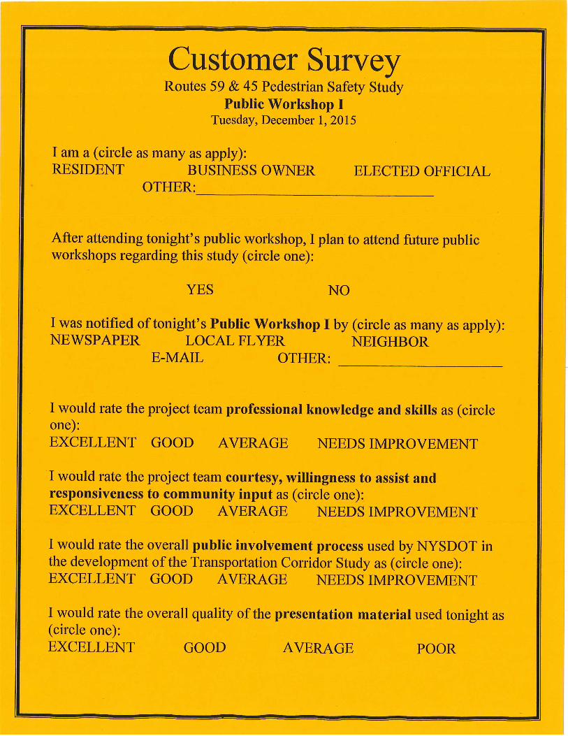

Page 1 of 2
Route 59 & 45 Pedestrian Safety Study
Public Workshop I – G
roup Exercise Results – Corridor Pedestrian Safety Needs/Issues &
Goals
Table 1 Table 2
Table 3 Table 4
Table 5
Priority #1 Ped. Safety Issue/N
eed
Discontinuous sidewalks
Lack of sidewalks and poor
condition of existing sidewalks
Lack of sidewalks
Aggressive driving M
otorists driving in continuous left turn lane
Goal 1, Objective 1
Sidewalks
Goal 1, Objective 1
Sidewalks
Goal 1, Objective 1
Sidewalks
Goal 2, Objective 2
Enforcement
Goal 2, Objective 2
Enforcement
Priority #2 Ped. Safety Issue/N
eed
Pedestrian signal timing
Lack of adequate pedestrian signal equipm
ent Pedestrian behavior
Missing sidew
alks Police need to ticket
unsafe drivers Goal 1, O
bjective 3 Equipm
ent Goal 1, O
bjective 3 Equipm
ent Goal 2, O
bjective 2 Enforcem
ent Goal 1, O
bjective 1 Sidew
alks Goal 2, O
bjective 2 Enforcem
ent
Priority #3 Ped. Safety Issue/N
eed
Children safety crossing the road
Traffic lights uncoordinated Poor bus shelters
Poor drainage Lack of crossw
alks
Goal 1, Objective 2
Crosswalks
Goal 1, Objective 3
Equipment
Goal 1, Objective 4
Transit Stops Goal 1, O
bjective 5 Roadw
ay Goal 1, O
bjective 2 Crossw
alks
Goal 1, O
bjective 1, SIDEWALKS
Four of the five tables had identified SIDEWALKS as one of their top three priority issues in the corridor. Three of those tables had SIDEW
ALKS as their #1 priority issue in the corridor, and the fourth table had it as their #2 priority issue.
Goal 2, O
bjective 2, ENFO
RCEMEN
T Three tables identified EN
FORCEM
ENT as one of their top three priority issues in the corridor. Tw
o of those tables had it listed as their #1 priority issue and the third table had it listed as their #2 priority issue.
Goal 1, O
bjective 3, EQU
IPMEN
T Tw
o tables identified EQU
IPMENT as one of their top three priority issues in the corridor. O
ne table had it as #2 priority issue and the other table had it listed tw
ice as #2 & #3 priority issues.
Go al 1, O
bjective 2, CROSSW
ALKS Tw
o tables identified CROSSW
ALKS as one of their top three priority issues in the corridor. Both tables had it as #3 priority issue.
Goal 1, O
bjective 4, TRANSIT STO
PS O
ne table had TRANSIT STO
PS as their #3 priority issue in the corridor.
Goal 1, O
bjective 5, ROADW
AY O
ne table had ROADW
AY as their #3 priority issue in the corridor.

Page 2 of 2
Route 59 & 45 Pedestrian Safety Study
Draft Goals &
Objectives
GO
AL #1 (Infrastructure) Im
prove transportation infrastructure through the implem
entation of strategic countermeasures and reconstruction projects to optim
ize the safety of pedestrians.
OBJECTIVE #1 (Sidew
alks) Provide a netw
ork of consistent, continuous, accessible (ADA compliant) and w
ell delineated sidewalks.
OBJECTIVE #2 (Crossw
alks) Establish a netw
ork of safe crossing opportunities with an average distance betw
een crossings that accomm
odates safe pedestrian circulation and accessibility.
OBJECTIVE #3 (Equipm
ent) Provide updated roadw
ay equipment including street lighting and traffic signals w
ith pedestrian indicators and activators.
OBJECTIVE #4 (Transit Stops)
Provide improved pedestrian access and crossing opportunities at enhanced transit stops.
OBJECTIVE #5 (Roadw
ays) Change the character of the roadw
ays through reconstruction projects that accomm
odate safe/convenient use by pedestrians, support traffic calm
ing and allow for efficient m
ovement of vehicles through the corridors.
GO
AL #2 (User Behavior)
Influence the behavior of drivers and pedestrians to increase and promote com
pliance with existing law
s while encouraging m
utual respect and courtesy.
OBJECTIVE #1 (Education)
Improve pedestrian and m
otorist awareness about their legal rights and responsibilities as drivers and pedestrians.
OBJECTIVE #2 (Enforcem
ent) Enhance enforcem
ent of pedestrian and motorist traffic law
s.

Public Workshop II

AGENDA
Route 59 & 45 Pedestrian Safety Study Public Workshop II Finkelstein Memorial Library
24 W. Route 59, Spring Valley, New York Thursday, February 4, 2016
7:00 PM – 8:30 PM
• Welcome and Introductions 10 minutes Supervisor St. Lawrence, Study Advisory Committee (SAC) member Sandra Jobson, RA, RLA, AICP, NYSDOT 7:00 – 7:10 PM
• Study Schedule, Public Involvement Plan & Summary of PW I Results 15 minutes
Sandra Jobson, RA, RLA, AICP, NYSDOT 7:10 – 7:25 PM
• Presentation of Study Draft Recommendations 25 minutes Sandra Jobson, RA, RLA, AICP, NYSDOT 7:25 – 7:50 PM
Scott Spittal, PE, VHB Consulting
• Break-Out Session 25 minutes 7:50 – 8:15 PM
• Next Steps 15 minutes Sandra Jobson, RA, RLA, AICP, NYSDOT 8:15 – 8:30 PM

New York State Department of Transportation
Routes 59 & 45 Pedestrian Safety Study Village of Spring Valley & Town of Ramapo, Rockland County
Study Flow Chart Including Public Involvement Activities
Elected officials notification—share study objectives and overall approach to be taken by the NYS Department of Transportation to successfully complete the pedestrian safety study
Pedestrian Safety Study—Existing Conditions & Field Audits STEP I
Conduct technical analysis & data collection of existing conditions, including gathering relevant data collected by others. Perform pedestrian focused road safety audits at select
study locations.
Meet w/Pedestrian Safety Study Advisory Committee (SAC)–introduce study to the SAC, share results of technical analysis & data collection. Confirm prioritized pedestrian safety locations based on crash data.
Determine locations for safety audits. Prepare for Public Workshop I.
Public Workshop I—Provide stakeholders with objectives of the study and overall approach including public involvement process. Share results of technical analysis, data collection & field audits. Gather
stakeholder input.
Pedestrian Safety Study—Select Safety Solutions STEP II
Based on information collected during Step I, develop appropriate recommended safety solutions in areas of Engineering, Education and Enforcement. Categorize solutions by
simple, moderately complex, and complex. Determine who would be responsible for implementing and determine rough cost estimates.
Public Workshop II—Provide stakeholders with corridor pedestrian safety study recommendations including associated costs and draft implementation plan. Gather stakeholder input.
Meet w/Pedestrian Safety Study Advisory Committee (SAC)–share results of Public Workshop II. Confirm recommendations and finalize study including implementation plan based on information collected.
(anticipate 1 mtg.)
Meet w/Pedestrian Safety Study Advisory Committee (SAC)–review the results of Step I and Public Workshop I. Review draft safety solutions in the areas of Engineering, Education and Enforcement. Reach consensus on
recommended safety solutions and draft implementation plan.
Pedestrian Safety Study—Issue Final Study Recommendations & Implementation Plan STEP III
Finalize and issue study recommendations and implementation plan based on SAC and stakeholder input; complexities of safety solutions; and associated costs.
Sept 1 2015
Dec 1 2015*
Oct 14 Nov 19 2015*
Dec 2015-Feb 2016
Feb 2016
Dec 17 2015
Jan 26 2016*
Feb 4 2016*
Feb 2016
Sept-Dec 2015
Last Updated January 29, 2016 * Signifies Actual SAC Meeting & Public Workshop Dates

Page 1 of 2
Route 59 and Route 45 Pedestrian Safety Study
Pedestrian Safety Goals, Objectives & Recommendations Public Workshop II – February 4, 2016 – Spring Valley, Rockland County
GOAL #1 ‐ Infrastructure Improve transportation infrastructure to optimize the safety of pedestrians through the implementation of strategic countermeasures and reconstruction projects.
OBJECTIVE #1 – Sidewalks Provide a network of consistent, continuous, accessible and well delineated sidewalks, including corridor‐wide ADA compliant ramps, thereby reducing pedestrian exposure to vehicular traffic. • Reconstruct existing sidewalk and curb ramps where they are determined to be either non‐ ADA
compliant or in disrepair. • Construct new sidewalk and curb ramps, where practical and none currently exist, to provide a
consistent, continuous and accessible network along each corridor. OBJECTIVE #2 – Crosswalks Establish a network of safe crossing opportunities with a reasonable distance between crossings to accommodate safe pedestrian circulation and accessibility. • Restripe all existing crosswalks that are in fair or poor condition, along each corridor with durable, high
visibility pavement marking materials. • Stripe new crosswalks where practical and deemed appropriate to better service pedestrian crossing
opportunities along each corridor.
OBJECTIVE #3 – Equipment Provide updated roadway equipment including lighting, signing and pedestrian signals. • Increase the level of roadway lighting at pedestrian crossings. Additionally, consideration should be
given to the installation of pedestrian level lighting along continuous sections of sidewalk to improve pedestrian comfort along each corridor.
• Rebuild existing traffic signals that are outdated and ensure that all are equipped with accessible pedestrian signal equipment.
• Evaluate opportunities to modify the operation of the traffic signals (timing and/or phasing) to result in improving vehicular and pedestrian safety.
• Review signs along each corridor to determine if new signs should be installed to increase driver awareness and improve pedestrian safety.
OBJECTIVE #4 – Transit Stops Provide improved pedestrian access and safe crossing opportunities at designated transit stops. • Evaluate the current uses of the Route 45 Spring Valley Transit Center and develop a site plan that
better accommodates the various functions and provides for safer pedestrian circulation. • Utilize transit infrastructure as a focal point for pedestrian safety education/awareness materials, since
most transit trips include a pedestrian component. • Improve pedestrian crossing facilities at transit centers, transit shelters and high‐volume transit stops. • Ensure existing and future Park & Ride lots, along the corridors, are designed and constructed to
support safe pedestrian circulation within the facilities and connection with adjoining transit stop.
OBJECTIVE #5 ‐ Roadway Change the character of the roadways through reconstruction projects designed to promote safe/convenient use by pedestrians and efficient movement of vehicles.

Page 2 of 2
• Traffic calming. Traffic calming is the combination of various physical measures that reduce the negative effects of motor vehicle use, alter driver behavior and improve conditions for pedestrians. Elements to consider include: Curb extensions at pedestrian crosswalks; Minimum shoulder width; Minimum lane width; Raised, planted medians; Pedestrian refuge islands; Traffic control islands; Street trees planted in buffer between sidewalk and roadway; On‐Street parking lanes.
• Mid‐Block Crossings with Median Pedestrian Refuge Island. Consideration should be given to the installation of mid‐block crossings with median pedestrian refuge islands where the distance between existing striped crosswalks is greater than 1,000 feet.
• Consistent Roadway Cross‐Section. • Consistent Speed Limit. • Route 45 On‐Street Parking. It is recommended “No parking” signs be installed or the sidewalks/curbs
be extended to physically prevent cars from parking to close to intersections and pedestrian crosswalks.
• Access Management. Review access to/from existing land uses along each corridor to determine where improvements can be made to better control access and reduce the number of driveways.
GOAL #2 – User Behavior Influence the behavior of drivers and pedestrians to increase and promote compliance with existing laws while encouraging mutual respect and courtesy.
OBJECTIVE #1 ‐ Education Improve pedestrian and motorist awareness about their legal rights and responsibilities as drivers and pedestrians. • Implement an education campaign to target both pedestrian and motor vehicle operators advising
them of their rights and responsibilities as users along each corridor. • Distribute pedestrian safety information through public health providers and in public buildings such as
libraries, community centers, recreation centers, places of worship and other sites. • Identify resources for local agencies (police, transportation agencies, local community organizations,
etc.) to conduct a pedestrian safety education program. • Conduct focused educational outreach efforts in conjunction with infrastructure improvement projects
• Sponsor pedestrian safety events with local educational centers to promote long‐term changes in pedestrian and driver behavior.
OBJECTIVE #2 – Enforcement Enhance enforcement of pedestrian and motorist traffic laws. • Employ an enforcement campaign, after an agreed upon period of education time has elapsed, along
each corridor by local police agencies to enforce traffic laws and help modify driver and pedestrian behavior with the objective of improving pedestrian safety.
• Provide local law enforcement officers specialized training in pedestrian safety to ensure familiarity with laws governing pedestrian‐automobile interaction.
• Invite law enforcement officers from Schenectady Police Department to Spring Valley and Ramapo to provide local law enforcement officers a presentation on the implementation of the “See! Be Seen!” initiative.
• Provide law enforcement officers with pedestrian safety education materials to distribute along with warnings or citations.
• Identify resources for local law enforcement to help support pedestrian safety targeted enforcement efforts and officier training.

![Certified Safety Auditor [SAC]](https://static.fdocuments.in/doc/165x107/58ab6d621a28abb54e8b4f0d/certified-safety-auditor-sac.jpg)