Answers of the State of Arizona to Interrogatories...
40
Answers of the State of Arizona to Interrogatories Addressed to the Complainant, the State of Arizona, by the California Defendants[,] Set No. 2, Arizona v. California, No. 10 Original, 1955 Term (U.S.). Landmark decision: Arizona v. California, 373 U.S. 546 (1963).
Transcript of Answers of the State of Arizona to Interrogatories...

Answers of the State of Arizona to Interrogatories Addressed to the Complainant, the State of Arizona, by the California Defendants[,] Set No. 2, Arizona v. California, No. 10 Original, 1955 Term (U.S.).
Landmark decision: Arizona v. California, 373 U.S. 546 (1963).

~· .. - ·--
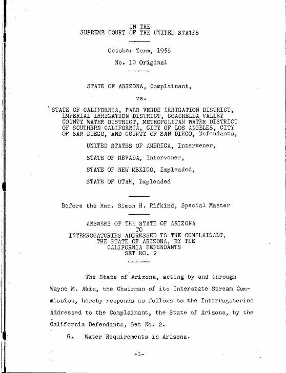
1~~~~~4 . . IN THE
SUPREME COURT OF THE UNITED STATES
October Term, 1955
No. 10 Original
STATE .OF ARIZONA, Complainant,
vs.
~TATE OF CALIFORNIA, PALO VERDE IRRIGATION DISTRICT, IMPERIAL IRRIGATION DISTRICT, COACHELLA VALLEY COUNTY WATER DISTRICT, METROPOLITAN WATER.DISTRICT OF.SOUTHERN CALIFORNIA, CITY OF LOS ANGELES, CITY OF SAN DIEGO, AND COUNTY OF SAN DIEGO, Defendants,
UNITED STATES OF AMERICA, Intervener,
STATE OF NEVADA, Intervener,
STATE OF NEW MEXICO, Impleaded,
STATE OF UTAH, Impleaded
Before the Han. Simon H. Rifkind, Special Master
ANSWERS OF ~HE STATE OF ARIZONA
TO
INTERROGATORIES ADDRESSED TO THE COMPLAINANT, THE STATE OF ARIZONA, BY THE
CALIFORNIA DEFENDANTS SET NO. 2
JOHN H. MOEUR Chief Counsel . Arizona Interstate Stream
Commission
JOHN P. FRANK JOHN GEOFFREY WILL BURR SUTTER PERRY LING THEODORE KIENDL - , For the Arizona Interstate
Stream Commission
ROBERT MORRISON Attorney Gener al of Ar izona
I.
I
l· I
IN THE SUPREME COURT OF THE UNITED STATES
October Term, 1955
No. 10 Original
.STATE OF ARIZONA, Complainant,
vs.
STATE OF CALIFORNIA, PALO VERDE IRRIGATION DISTRICT, IMPERIAL IRRIGATION DISTRICT, COACHELLA VALLEY COUNTY WATER DISTRICT, METROPOLITAN WATER DISTRICT OF SOUTHERN CALIFORNIA, CITY OF LOS ANGELES, CITY OF SAN DIEGO, AND COUNTY OF SAN DIEGO, Defendants,
UNITED STATES OF AMERICA, lntervener,
STATE OF NEVADA, Intervener,
STATE OF NEW MEXICO, Impleaded,
STATE OF UTAH, Impleaded
Before the Hon. Simon H. Rifkind, Special Master
ANSWERS OF THE STATE OF ARIZONA TO
INTERROGATORIES ADDRESSED TO THE COMPLAINANT, THE STATE OF ARIZONA, BY THE
CALIFORNIA DEFENDANTS SET NO . 2
The State of Arizona, acting by and through
Wayne M. Akin, the Chairman of its Interstate Stream Com
mission, hereby responds as follows to the Interrogatories
Addressed to the Complainant, the State of Arizona, by the
California Defendants, Set No . 2.
~ Water Requirements in Arizona.
-1-

r l
i
I ,I !i [i il
.~i ~ ' I : I : i : i ; I
; I --------------------
' G-1 PLATE I. MAP OF A PART OF ARIZONA
EXPLANATION
::;:~~~~:~i ~ ~~Lo"u~~~~~T~~Ai~:~G~ BASIN
--~~~~~·6~w·:TOE~E~!~~:T AREA WITHIN .
GROUND-WATER BASI~
l·SALT RIVER VALLEY BASI~ IA,•(IUEEN CREEK CRITICAL AR E I\ lB.-SALT RIVER VALLEY CRITICAL A~[,t
2.•1.0WER SANTA CRUZ BASIN 2.A! ELCY CIUTIC,U. AREA tii.• CAS A ·· GRANOE·F'LORENCE CRITI C Al A~ EA
3.- AVR A•ALTAR BASIN 4.· U"'!R SANTA CRUZ B ASIN 5.· UPPI:IIt SAN PEDRO IIASIW ~·\.OWER SAN PEDRO BASIN 7.-UPPI!R SA~ SIMON SASIN 8.- L OW£ft SAN SIWON-SAFP'OR 0 DASIN t. · OUNCAH BASIN
i
I li II

Net
The answers to these three questions are consolidated as follows:
Maricopa County~ Arcadia Water Co. ------------------------Arlington Canal Co, ----------------------Buckeye Irrigation District --------------Broadacres, Lone Butte, and
Ocotilla Farms -------------------------Chandler Heights ----- --------------------Enterprise Canal Co. ---------------------Gillespie Land & Cattle Company ----------Goodyear farms and Adaman Municipal
Water Co. ------- ------------- ----------Indian Lands ------------------------------Marinette farms ------------------~-------Maricopa County Municipal Water
Conservation District ----------------~-Peninsula, Horowits & Champion and
St. Johns irrigation district - ---------P_rivate pumps: · East of R. w. c. D. --------------------
North of Arizona Canal -----------------South of Salt River Project ------------West of Agua Fria River -----------------
Queen Creek Area -------------------------Roosevelt Irrigation District ------------Roosevelt Water Conservation District ----Salt River Valley Water Users' Project ---Miscellaneous projects along lower Gila ---
Total Maricopa County -----------------•
Pinal County: San Carlos Irrigation and Drainage District:
White lands ------------------ 50 000 Indian lands ----------------- so;ooo
Queen Creek and Magma area ---------------Electrical Districts 2, 4, and 5
not included in San Carlos District ----Stanfield District -----------------------Papago Indian lands -----------------------
Total Pinal County ----------------------
Total, Maricopa & Pinal Counties --------------
-3-
Acres 1,550 4,480
19,200
8,175 1,290 1,000
20,800
13,450 7,640 9,000
35,000
3, 730
5,000 11,000 16,920 20,600 16,080 38,000 39,500
242,000 7,950
522,365
100,000 4,000
147,000 35,000
351
286, 351
808,716 '
I II

Of the foregoing lands, the following have storage facilities:
Salt River Project (On Salt & Verde Rs) ----Coolidge (San Carlos) Pro~ect (Gila R) -----Maricopa County M.W.C.D. Hl (Agua Fria) ----Roosevelt W. C. D. (Rights on Salt R) -------
242,000 100,000
35,000 39,500
Total having storage facilities ----------- 416,500
Other projects having stream diversions are as follows: Buckeye Irrigation Project ------------------ 19,200 Arlington Canal Co. ------------------------- 4,480 Gillespie Land & Cattle Co. ----------------- 20,800 Indian Lands -------------------------------- 7,640 Enterprise Canal Co. ------------------------ 1,000 St. Johns Irrigation District--------------- 3,730
Total ------------------------------------- 56,850
Total acres having stream diversions ------------ 473,3 50 '~ Total relying entirely on wells ----------------- 335.366
Total------------------------------------- 808,716
':' All surface water comes from the Gila River and its tributary streams.
Normally up to 10 per cent of farm lands are out of crops for farm building sites, roads, wasteland, and so forth.
Deducting 10 per cent of the foregoing ---------- 80,872 Net irrigated and water right lands,
Maricopa and Pinal Counties ----------------- 727,844
-4-
------------------------------- ·

G-6
QUANTITIES OF SURFACE WATER AND PUMPED WATER BY PROJECTS IN MARICOPA AND PINAL COUNTIES, ARIZONA
·YEARLY VALUES IN ACRE-FEET
SALT RIVER PROJECT SAN CARLOS PROJECT ROOSEVELT WATER CONSERVATION
DISTRICT Surface Pumped Surface Pumped Surface Pumped
Water \'later Water Water Water Water
(l) (2) (3) (4) (5) 1922 1,054,000 110,000
23 1,072,000 150,000 24 1,211,000 170,000 25 870,000 310,000 . 26 809,000 252,000 27 958,000 250,000 28 1,103,000 275,000 29 849,000 255,000 57,000 Included
in 30 743,000 350,000 222,000 column 2 29,000 31 760,000 340,000 240,000 values 21,000 32 1,073,000 65,000 268,000 diverted 1,000 33 887,000 265,000 327,000 at 4,000 34 861,000 290,000 204,000 39,000 Granite 34,000 35 949,000 260,000 231,000 67,000 Reef Dam 34,000 36 1,042,000 270,000 245,000 108,000 42,000 37 1,236,000 190,000 385,000 71,000 57,000 38 1,033,000 390,000 188,000 103,000 65,000 39 757,000 330,000 114,000 103,000 65,000
40 658,000 370,000 161,000 99,000 70,000 41 1,072,000 70,000 265,000 56,000 45,000 ' . 42 1,079,000 340,000 376,000 100,000 95,000 43 969,000 410,000 372,000 91,000 100,000 44 994,000 325,000 296,000 113,000 100,000 45 971,000 430,000 224,000 102,000 90;000 46 907,000 395,000 99,000 100,000 90,000 47 715,000 395,000 74,000 122,000 85,000 48 692,000 390,000 78,000 130,000 105,000 49 $05,000 375,000 244,000 118,000 85,000
I I 50 751,000 480,000 141,000 142,000 106,000 I 51 552,000 430,000 40,000 100,000 96,000
I 52 817,000 340,000 231,000 102,000 86,000 53 737;000 437,000 60,000 117,000 100,000
I 54 736,000 473,000 104,000 I
55 696,000 468,000 94,000 f. ~
Jj I J
li -5-II

l~ricopa County Municipal :later Arlington Gillespie Lnter-Conservation Buckeye Canal Ylater prise District Water Cons. Company Co. Canal Surface Pump Surface Pll11lp Surface Surface Pump Surface l'later Water Water Water 'l"iater Hater Water Viater
(1) (1) (2) (2) (3) (4) (5) (6)
1922 116,000 23 165,000 24 151,000 25 157,000 26 169,000 27 158,000 28 32,000 154,000 29 0 137,000
30 15,000 129,000 31 30,000 116,000 4,000 32 40,000 124,000 1,500 33 23,000 103,000 9,200 34 5,000 90,000 11,300 35 29,000 98,000 10,200 77,000 36 14,ooo 98,000 13,500 69,000 9,900 37 54,000 106,000 9,800 84,000 8,300 38 13,000 97,000 15,600 75,000 7,500 39 8 , 000 33,000 15,200 64,000 6, 800
4o 9,000 34,000 76,000 21,800 6o,ooo 6, 900 .41 53,000 1, 300 118,000 4,300 (1940-1.;4 96,000 (1940-44 7,600 42 89,000 43,000 86,000 14,900 ( 27,600 78,000 ( 24,900 7,400 43 17,000 75,000 80,000 15,400 ( 5-Year '65,000 ( 5-Year 6 , 800 44 39,000 86,000 82,000 14',800 (Average 73,000 (Average 8,4oo 45 36,000 100,000 78,000 19,700 75,000 7,300 46 10,000 80,000 82,000 27,500 73,000 7,200 47 6,000 70,000 62,000 41,000 73,000 9 ,900 48 4,000 79,000 42,000 69,000 46,000 8,500 49 29,000 54,000 41,000 60,000 39,000 8,300
50 10,000 54,000 32,000 73,000 31,000 8,900 51 500 48,000 34,000 76,000 28,000 9,900 52 61,000 4 3,000 47,000 60,000 4o,ooo 7,900 53 48,000 55,000 33,000 80,000 21,000 8,300 54 28,000 55,000 37,000 83,000 16,500 9,100 55 17,000 61 ,000 36,000 72,000
G-7 The information requested is not readily avail-able in terms of counties. Our answer to the question as a whole is: Considerably less than 50%.
I I -6-I i I.

I
I
G-8
IRRIGATED LANDS ARIZONA By TRIBUTARIES AND COUNTIES
Little Bill Gila Colorado \'lilliams Virgin I.'Jaricopa Pinal River River River River County County
1940 558,000 22,000 4,200 890 356,000 127,000 41 652 23 4,100 900 395,000 173 42 67.3 23 4,000 810 402 186 4.3 631 23 .3,900 810 .376 172 44 641 23 .3,800 820 397 164 45 598 23 3,700 830 370 147 46 564 23 4,200 795 356 1.30 47 646 25 4,200 760 .398 169 48 716 25 5,300 650 439 187 49 785 25 6,600 625 452 231 50 731 24 7,800 620 431 202 51 891,000 24,000 9,000 595 515,000 251,000
The information for the last three years is not available.
G-9 This calls for predictions which we are unable to make.
G-10 Insofar as this question calls for predictions, Arizona is unable to answer. The balance of the information sought by t his question is not readily available.
G-ll(a}
7-1-44 to 6-30-45 7-1-45 to 6-30-46 7-1-46 to 6-30-47 7-1-47 to 6-30-48 7-1-48 to 6-30-49 7-1-49 to 6-30-50 7-1-50 to 6-30-51 7-l-51 to 6-.30-52 7-1-52 to 6-30- 53 7-1-53 to 6-30-54 7-1-54 to 6-.30-55
Total
34,.315.76 58,694.09 20,010.35 12,998.17 19,050.19 10,396.01
3,.341.51 3,863.68
6.12 .3,587.26
166,26.3.14
The foregoing information i s not limited to irrigable l ands.
-7-
I'
'• I ,,

(b) This information not available.
G-12(a) State totals only available through June 30, l95l as follows:
Year ending Acres Leased
6-30-45 6-30-46 6-30-47 6-30-48 6-30-49 6-30-50 6-30-51
142,610.06 191,433.52 249,259.01 283,781.30 270;397.81 286,370.27 289,447.46
State land leased by counties July 1, 1951 through June 30, 1955, as follows:
7-1-51 7-1-52 7-1-53 7-l-54 to to to to
6-30-52 6-30-53 6-30-54 6- 30-55
Apache 1,826.77 2,141.54 1,639.54 1,461. 54 Cochise 4,052.67 11,449.06 15,869.08 9,550 .48 Coconino 1,310.00 1,250.00 1,277.00 1,277.00 Gila Graham 280.00 396.92 396.92 276.92 Greenlee 481.10 521.10 521.10 521.10 Naricopa 62,738.86 61,165.33 58,958.83 56,135.56 Mohave 824.09 1,384.09 1,304.09 496.49 Navajo 320.00 200.00 . 160.00 Pima 10,265.29 10,149.53 9,664.11 9,664.11 Pinal 79,715.73 75,472.45 74,142.98 70,812.53 Santa Cruz Yavapai 800,00 480 .oo 480.00 480,00 Yuma 165,158.96 144,527.18 139,020.15 . 90,745.69
State Total 327,773.47 309,137.20 303,433.80 241,421.42
The foregoing information is not limited to irrigable lands
1Ql This information not available.
This information not readily available.
G-14 This information not readily available.
.• G-15 The inadequacy of the water supply became known f to this complainant in December of 1947.
j_ -8-

G-16
l. DUNCAN VALLEY, GREENL~~OQNTY:
Area of ir.vestigation ------------------Assumed coefficient of drainage --------Estimated decline in water l evels 1944-54 Esti mated decline in storage underlying
16,000 acre~, 1944-54 ----------------
2; SAFFORD VALJ~Y, GRAHAM COUNTY:
Area of investigation --------------- - --Assumed coefficient of drainage --------Estimated d~cline in water levels 1944-54 Estimated decline in storage underlying
37 , 400 acres, 1944-54 ----------------
3. SAN s~.mN BASIN. cocHISE couNTY:
Valley area ---------------------------Assumed coefficient of drainage ----- ---~ Decline in water levels at well s measured
1944-54 ------------------------------Records insufficient to determine amount of decline in total storage .
4 . UPPER SAN PSDRO BASI N. COCHISE COUNTY:
Area of recent alluvium --- -------------Assumed coefficient of drai nage --------Estimated decline in water levels 1944- 54 Estimated decline in storage underlying
recent alluvium ----------------------
5. LOWER SAN PEDRO BASIN:
Area of recent alluvium ----------------Assumed coefficient of drainage --------Records insufficient to establish a definite trend .
16,000 acres 16%
5.66 feet
14,400 ac. ft.
37 , 400 acres 16%
12.5 feet
74,800 ac . ft.
640,000 acres 6%
16.5 feet
25,000 acres 1 5% 3.5 feet
13,125 ac . ft.
23,000 acres 15%
6. UPPER SANTA CRUZ BASIN, PIMA & SANTA CRUZ COUNTIES :
Bottom land area -----------------------Estimated effective area pumped --------Assumed coefficient of drainage --------
600,000 acres 400,000 acres
10% Estimated decline in storage , I pumped area, 1944-54 ----------------- 605,000
j_ a c. ft.
-9-
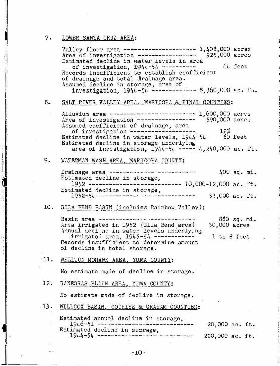
' I
7. LOWER SANTA CRUZ AREA:
Valley floor area --------------------- 1,408,000 acres Area of investigation ----------------- 925,000 acres Estimated decline in water levels in area
of investigation, 1944-54 ---------- 64 feet Records insufficient to establish coefficient of drainage and total drainage area. Assumed decline in storage, area of
investigation, 1944-54 ----------~-- 8,360,000 ac. ft.
8. SALT RIVER VALLEY AREA. MARICOPA & PINAL COUNTIES:
9.
Alluvium area ------------------------- 1,600,000 acres Area of investigation ----------------- 590,000 acres Assumed coefficient of drainage, area
of investigation ------------------Estimated decline in water levels, 1944-54 Estimated decline in storage underlying
12% 60 feet
area of investigation, 1944-54 ----- 4,240,000 ac. ft.
WATERMAN WASH AREA. MARICOPA COUNTY:
Drainage area ------------------------- 400 sq. mi. Estimated decline in storage,
1952 ------- -------------------- 10,000-12,000 a c . ft. Estimated decline in storage,
1952-54 ---------------------------- 33,000 ac. ft.
10. GILA BEND BASIN (includes Rainbow Valley):
Basin area ---------------------------Area irrigated in 1952 (Gila Bend area) Annual decline in water levels underlying
irrigated area, 1945-54 -----------Records insufficient to determine amount of decline in total storage.
11. WELLTON MOHAWK AREA. YUMA COUNTY:
No estimate made of decline in storage.
12. RANEGRAS PLAIN AREA. YUMA COUNTY:
No estimate made of decline in storage.
13. WILLCOX BASIN. COCHISE & GRAHAM COUNTIES:
Estimated annual decline in storage,
880 sq. mi. 30,000 acres
1 to 8 feet
1946-51 ----------------------------
]_·------------- --E-st-~-~-4~=~. "=~~:~=-:~-~~~~~~=~----------20,000 ac. ft.
220,000 ac. ft.

I i I
I
j: I I ·
i: :
14. DOUGLAS BASIN. COCHISE COUNTY:
Estimated annual decline in storage, 1946-51 ----------------------------
Estimated decline in storage, 1944-54 ----------------------------
15. OTHER AREAS IRRIGATED WITH GROUND WATER:
Only meager information available. No estimate made of decline in storage.
17,000 ac. ft.
187,000 ac. ft.
In most of pumped areas, some decline apparent.
G-17 The statistics requested are not readily avail-able for the years 1922-1940. The answers to these questions are as follows:
-11-
' l ' ·~ ~ .\
·I :I I. l .j
, ; :; .,
;I

II
ARIZONA CROPS IN 1241-AOtEACZ: AND P1\.Q])UCTI01f IIY COUN"''m:S.
Ywno
PJUHCfPAL ARIZONA CROPS IN lti-41-·ACREAOl; BV COUNTJU AND 1"1\0DUCTION rOR 'tH& &TATZ.
Btale total Apachl' CO('hiiiC.' Coconino Oraham Oreenlu Mark'opa NavaJo P)ma Pinal Yavapai Yuma
1,1100"' too
300 """ ''''700 :000 '2:400 . 400 "'"100 1-::;oo
eoo f.fOO ··~eoo. ~ -·ro.
··-··-· ····-··o -~-··o
12,000 1,000
5.100'·
10,1'00
ii':CiOii
1.100
3iiii ' 200 'i.OOO
0
··· ····o 33,000
100 111,000~
1,000 1&3,300
'TOO ·4,;400
3(10 31,1100
''i;jjj-. . "1:100 500 '.11;300 200 ·n:Too
"""ii:iii -=· 'jj;;oQ, ----iii)
'i'i;OOO. "'1:000·
5,000 390,000
uoo 1.000' 21,(100"' ··.GOo. -• . 100"'
1,000 suoo -.;.oo . ., •• .. .....
--~-300 ~J,OOO 1.100 400 , ,100
i"i~;oo ·1::;oo --·r;ooo ·r . .oo -» ""700 ·uoo ·--a:IOO .. soo ·;::;QO.. '1:000 ""700 '"1:100 iiOO ....
100
. * ·a.ooo ao-. ' 'l:iW.
'"i;toii
4.200 • 37,.500
3.000~ 1.000
"""
*" JJ:OOO. it.iiO
--:--- ·· '(GOO· .. _ .....
' "'"'0
100
·---.oo
71,000
Yuma
...... ..... .. 'iOO
11,000
l .•• ,: •. '. ------Nolc.-crop ac:rcaRl'" not nomcd abrJYe ll"'clude autar beeta harvt&tc:d for aetod : Milrlcopa Count)', t .71d acnoa; Gnham County, 134 •crca: putahM•II: 111,500 acru: and ama11 acrc:aae!'l nf othet cro p:-~ such •• oau and guar. Stat• totala Include c•tlmatt'a tor Gila. MlJhiVI.', and S11nli1 Cruz c:nuntk'a.
Sr,urt't'.-Burc.:uJ nf A•r1cullur11l Economtca. PhCH!niJC om.ce, except aa otherwl.e noted. · •Alfalfa aeru~ee- ...,me-wh11t lart:('r than Sur. or Al!:r. Eeon. report. of harVt'lted ac:reaxe b~au.e c:onJidl.'rablto IICnaKt-, t'IIJCCially In Pinal County,
~E:~·~~:e~~:~~;t ~~c~1r,btc~~~~~~~~~ully of Arizona. . •Include• araln In alb.r..l[l.',_ and fnr~o~~o:t'. •Ouc.-tl nol lncludr potatOt'l. • Yt-ar rmdcd AUJI:UIII 31, 11)U . 'l'lcurt~ r t-pr t Nnt both lrrhcalt'd t'rUPII and lrriJtatt'd ~JIItUrl'. In oddttlnn, 11 I~ nctlmat<'d lhat dry•land crup!C Wl•rt' t\crVl••tt'd rr un1 upttmxltn lllh•ly M.OOO atrt'•. •
•Not ln<>ludln• W ar ArhoC"nUun Aullte+rlly :u·~·~~•Trlf'h' 1\ lii' IIU'S
l i· ' ~·
~ ' '· ..
I ' I . •I
jj ~ I
11 il II -!
l! ' i: r ii
I' !!
I!
11
!I "

I
! i
I i
PJUNCJPAL ARIZONA CROPS Uf ttK-ACRZAGE BY COUN'nD AND PltODVC'!':ION roJt ,lm BTAft
Attatta: Kf'ltt .... ~---···---~-----·· m.ooo Ton.t nat tor .,..,. ________ ..:::____ aa,ooo Cotton
U=:ol~-===~ ::::· ~~~~: ~ ::~ ............ B.rleJ: •~------·-····· ",l,OOO
Co~ ::r&.~~::::·-·· g:: T~ or etatn ···-··- - --· ... .: to.ooo
Cratn aorrhums: .c:;'"e•--·- 13,000 .
'flbe~ .:~~~-~::.:::::::-=::. i::: J ToN or Kr•ln--------- -----··· u ,ooo ~~b~~=--~~~:::~.:: . 1~:: Veptable ero;wrl: aern" ......... : ,4,000
can lhlpptd.• ....•..••... - .••..••.. -... St,OOO Flax: ar:r.s ... ,. ____ ., .... ------·--··-· 11,00)
Tons harvnttd ---------··-·- lZ.IOO Grapotfrutt: acres"·--·-··-·- tt.eoo ·
Ton.s bU"Vt"''\e<e•- --- ----- UO.OOO Orana:e-a: &Cft't."-···----------- .,,.
'·""
---·-·
1.000 ..... 10,1)00 ....
-liD.GIO
<1,300
·-···-'50;tici ~-1.100
- ToO ·u:o;;o -'ii"Jii -I ·a ·
--, 1.'100 .......
........... J:iii - -1,'1110 u.• --- '''Uiii .... li:iii - "ii)O -,:;oo
~-- -a:aoo · ... 1:oao.
Tons harvested.• .. -----------·· tl ,OOO
A-.... =::.,.:,,.,.='":..:.=...,:.:::.::..: ... = .... = .... =.,.= .... = ... = .... '-. +=,.:::::: .... =-. r.":: .... :::::.+-,;li·==·::; ... ::t~·~· ... 'i~~~-= .. ,:-:"".•:··=-~t-=-=';-;·...,:::r:= ... =,;=: .... ;:j::f·:· ... ;:1::•I .... ;E:t' f•'"f·;. ... =,;,=-,;i~""'·,;,~•: .... ::~c;;'D,OOO"';;";;"'=-Soul'ft.-~e Fickrat Crop an-d iivmOCt ~pori~a: ServiC-e. 1'-hoenlx. ex"'pt •• oth~;;ii.. nott4. •St.t~ totalt. b\clude nttmatH for GUa, Mohn1!, and Santa Crw: eountlH. · . .,EsUmatn ot ~rtment ot AarltuHunl Econom~ Untvenll7 ol ArhOftll. "lnducks rraln in 1111~. and t oraJ.e. "Yeu ended Au.cust 3J, 1M4. DoH not lncludt: 8.000 act"H l t bh potators, .. Year ended AUJUit Sl, 1M4. . . . •rtrurn "pruent both lrrlrated crops and lrdJ&t.ed pasture. ln addltlon. lt b ~stlmate<l that dry•Jand ~ro~ were harntted ll"om 41pproxhnateb' a.ooo aeres. ·
•Not tncludtnr War Rel~atlon Authority area,
..... total• . APKM Cochbe C«ontnc Graham GrHnleoe Marlcop.a Ptn•l " Yn1pal Ywn• N .. olo~
A7t~b~u~.~,~K~no=-.. -... -.. -.... -.... -... -. t.~..,~ .... =-+-7,....,~-+~,.~==--+~=,oo~+-=-e.ooo==--+-,~~==--f-:,~~~ .... ==-1-~.~~=-~ I.I00{--.~ .... ~~7 •. =,~~j-.~...,.=-co1=: ~~r -~-~-=:=::: · ~ll:: tf.TOO i:250 ~ 'ti400 000 n:;oo iiiii
Bale. of cotton - - ··- JZ5.000 Fe-ed tral.n.S j
lb.;!c:rs: ar:::~~~-~~=:~:-_- ! ~:= -I. 1.100 corn : acn11 .................. ! 31.000 . ,. 10:i0o
Tons of train ............ 1 12.231
w:fi~·J::::~~~::; ! = 1. i:: .. er";.on~i:~e ':~!:an:e; : lt= -. i.OOO
T ons Nit'Y'Hted . .. .. 3.100 Vuetable CTO~; acr- : • 'JS.OOO
Cars shipped• · · 40.000 Flax: acrn .. .. ................... · ' 17.£100
-3,l00
' iOO "toO ' 'ioO "100
J.Dori
. 300 .
·;oo "i:iO ...
~ .... .. .. 100
·:n:oOO ..... -· .. ioo -~.000
... 5$0
... 10:300 ... i::KX;
...
... l:.ZOO "ijO
-j.iiOQ
3,l00
Cnpefn.~tt: a crn• _.,,_,., 12,100 'i i,!OO 'i':ilii Tnns harvnwd ...... : ...
1
. l1,tx10
0~~!,~=· .. =~-=-~ 1~ . 1.000 . -Tons h~' ..... _._ ~.000 . ~--..
;o"c~re·=·~'··~"="='""=·=· ·=·=====·m= .... ===="=·"""===;= ... = ...... = .. c=" '= 33=.1.ioo= .. ='=,.=~· ... ====·= .... ===""'~····~·~._:~ -~~l'"iii~-rti~c~~ Source.- The Federal Crop and L1vntoc-k &port!na Servtcr. Phoenix, ucept a1 otherwtsc noted. •State Cl>ials include fttlm..&n for Gila, Mohave, and SanU Cru% counties. •·IndtllHs , ,000 ao-n: of Amerian·Egypit.an cotton. . . · • Dot:1i not Include traJn ln u.oao atrf'l Of allare and forace. •Year ended Au«uat 3J, IMS. Dot-s not Include 1..500 aeres Irish potatoe-s. Esttmaua ol Deputmcnt Of A&rleultural Economlcl, Unlv. ot Arlzona. • £stimau-s ot Depart"""' nt A• rk'ultwal k onom;n, Unlvt:n.lty of Arizona. •v~-.r ended Au•ust. 31, IN). · . _ . . • :F utul't's t eprnrnt both l rrluUd C"roJ)s and lrrlukd pasture. Acrnce doub~·c:ropped iJI Counlt'd hut once, J" addJUan, Jt l1 ntlmaa.d that dr!' · l."'nd c rJJP"' we~ h.arvnled fMm approxlmakly 8.5.000 acru.
PRINCJPAL ARIZONA CROPS lN JH&-ACJU'.ACE BY COUNTII:S. AND PJlODUC'I"'OH FOR TID: STATZ
c ..... -·-- -· - ·· ----..... .., ..... Apec:hll Coc:ht.e Coconino Gr.ham
... 2.000 700 5.a»
ti.D
G....,. Me llarteopa Nuejo Plme PUlal YaYalNl YUrNI
l.D. 111,(100 2iiO ~ ~,000 ~ --.:ooo n:-... . 1'0:".0. 11:000 ...... ... ......
i
jl
,I II
li li il ii

II
PRINC:IPAL ARIZONA CROPS IN lH7 ACitEACE BY COUNT1ES AND PRODUCTION FOR THE STATE
11>4,000 02,000 32,000 10.000 50,000 eo.ooo• 28,000 17,800 14,000 3,000
100,000 47,000 20,000 u.ooo 11.200
·~;;: J7,000
.vr. JrrtpU<~•• ....... 12S,OOO IJ,OOO 23,000 J,OOO 35,000 1!,000 U:I.OOO 8,000 'o".'o"o"o' l2~~.~~~ '~.~~- .. _.000
..,_.,.. c.-.. ,. .... ~~ ....... ! .... 4J~f -1,800- ·-- 700
.. ~... ! ............ 1 ... ~ ... . 5,100 8110 106,50CJ
'ii;400 le,OOO 'i.800 as.ooo
3.&00 200 131,000
. '100 500 ' i.300
1100 500 ' ii7,ooo
1'1"'" 1 ;~:~ I r~ . .... ~ I "~~ .. t,liHt :l,300 21,011-11 J,IWII :l!,,,')IHI
J4:io0 tu:Ooo :t.21»tJ ..... .. ...
400 3,000 1',000 l,IDO 4.1011
12:500 ·t:4oo 100 ·aoo tl)ri
""300 ·:~:toO ' IO,ooo :too 2.Di,ij ··i:soo ltoo ... l.2oo ·,:oo 1,30~
""i,OOO
:.::::
.. 300
... 2.000
uoo
1:1oo .. ·- 31,000
. 'i'OO 24.aiiri 1,2(-,(i
500 a.ooo I 3o.ooo -1 250,ooo 11.ooo I Bs.Ooo
Sour~; The Federal Crop and Live1tock ~portint Service. PhOt-nb, elCt'C'Pt a~ utherwi~e note-d. •Sta.k lotala Include etUma~ tor Gila, Mohave, and Santa Cruz oountl"'~-•tncludes Amtrkan. EQ'ptlan cotton, 1,450 acres in Graham County, 130 ilCrt:s in Markop<~, and 20 acres in Pinal, with a pru~ duction of approxlmakl7 1,100 b. ln. ~non not lnclud:e poaln in 13,000 ac~s harvnted !or lilare and for:~ge. ~Y .. r rndcd Autust 31, 10·411. "Eitlmatrs of Drpartment of Arricultural Economics. Univeulty of Arizon;~_ 'Firurn re-p:re~nt both irrlrat.d crops and Jrrigated pasture . Acreil~re double l·ropped Is counted but on~·c. ln uddition, it iJ> estf~ mated that dt')'-ls nd crop1 'W•re harvested !!'om approx imately 155,000 acrC's.
PRINClPAL ARIZONA CROPS IN I!Jf&-ACRF.AGE BY COUNTIES AND PRODUC'rlON FOR THE STAtt
: ... ,., .... ~~- ~~~;~:=l~ri_ ~~~~· ~~~·-~;.:~~1!:~-~l~~ t;;t. 30.000 .. ~~ ~:.~·~ Alfalfa: acres --.-......... 201,000 t,300 2,000 700 5,200 800 127,000 2,300 ~-"00 18,!lo00 4,000 n.soo c Tons c:ut for hay .... sn,ooo iJ:OOO 0~~! o~e:~:on............ ~~~:~~ .... .. 21,000 174,000
FHd ll'llllul ....... , ..
Barley: acre1 ........ _ 136,000 StOO 400 300 3,i00 200 • U9,000 400 2,000 151,000 1,200 7,300
cc~~a~e:r~~~ ... :::::::: ~~~::g ·ii:soo .. 1:ooo 3;6oo ··-:;oo . "SOii ... 1:200 l3.ooo J,5oo aoo eoo ...... 100 cr~f~50o:,:~~ ~~-~~-;~ ~i:~~ .... 200 ·3:soo ··:zoo .... ,oo -·600 ·ss:ooo --· 300 a,5oo 1o.ooo ·--·3oo ... 2:000
Whe!'~ns a0:re1s'1.1.~ •• :::::.·:: 1!:~:· ""900 806 i;?Oi:i '"'800 ··200 '13X6ii ·1:400 ""800 ... f:too -·-·;;oo --J;Soo Dry ~?:1e0fb::~!~ &;;;·~ · ii:gg~ 700 '100 7:f00
Tons h a rvested 2,70() Truck crops: aeus" .... 100,000
Cars shipped'' ·------- 40,00<.1 n.x: acres .. ~ ....... -..... 38,000
Tona harvested .......... 27,000
'"'500
200
... iOO
Grapdruit: acres• ...... 10,000 Tons sold~• .......... ..... . IIJ,OOO I,SIOO """'40
~~es~ol~e.~t~~--::: ____ ,_ 2::~og Lemons: acres ····--.. 850 '"'"640 ·-- ·--Sourt'f": The Federal Crop a nd Livestot'k Reporting Servn"!. PhDf'RJX, exC'ept as otherwla noted. "Slate tobb include fttimates for Gila. Mohave, and Santa Cru1 countif's,
.. ""'
'EIUmaWs ot the Department ot Agricultural f:c:onomic:s, Univeuit7 of Arizona. "Figure• re-prf'sent b<lth irrij'atcd crops and irrigated pasture. Ac:~ate double cropped 1.s counted but once. In addition, it t. estimated t.hat dry~Iand croJ)s were harvil!'!tE!d /rom approximately 65,000 acr-es. Hence the~ oa Uti.lline do not represent crop acreage total.!,
•lncludf's Ameriean-EJ'YPtian cotton, 2,000 acru in Graham Ccunty, 700 ann In Marfc:op., 100 acre. in Pinal. U'ld 100 act"hh In Pima, with • production ot approximately 1.700 bales.
'Does not Inelude vain in 17,000 ac~s harvestf'd for ailace and Corace. 'Year ended August 31, 19f8. •Includes 1,'100 acre-s or chUI.
I
' i
'I H

I ,. I
,==~P;;R;,;IN;c;C_!~~.:-~~I~NA ~~~-~~~! ~~:~ -::.~~~t.AC£ BY COUNTIES AND PRODUCTION FOR THE STATE
t~::t. l A1• .. h .. Co,.~IH t;;t.:. (;ntu,.., c:,.....J ... NorH-1•1"0~ N• •• ;., l't..•• l'lrrol j\'•••1 .. 1
Acres irrirat~ .. • -- - ···- .!£~:~L1iooo 20.~ _2:_00~ ~-~ -- -~-·~ 43$,000/._ 1.000 ~· -~ ~$O,~o l 11 ,000 too,ooo
AU.all.a: acn:~ ........ ~······--·· 1'ons. cut for h1y" ......
CoU<'n; Upland- I Cr~s -·····-··· Amu .• Etypt.-AcrH ..
B.ales' Baits' .... .. .
FHdCralns Bari~J-acre5 ···--------
Tons of cn.in Corn-.ac~ ....................... .
Tons of rrain ···-~·-······· Crain sorV1um-.acres ···
Tons ot min' -----..... Whnl:<~crcs .... ............ .
Tons of (rain . ... :.-.. ..... . nry edible b u ns: OJC res ·-···
Tons harvnltd Vtcetables: .acr"*s"' .
Cars shipped'' . n a:r.: acres ................... .
Tons han ·Hted ···-···~C rapdruit; acres~ ''' "'"" '"'"
Tons sold' ' ..... ......... ....... . Ora ncf'S; a crf'!i~ ... _,., ... -...... .
Tons 10ld' ' ......... .... ..... - . Lemons: acres' ···- ··· .. ·-····-
201,000 4,300 2,00<1 !163,000
231,000 s.ooo· 42.000 100
430,000 35,000 ...
"i~JOO
'4.200 ""700 ... t.ooo•
700 ·~ .. ••• 126,000 :z.zoo
U ,700 u oo 13,000 5,800 -i:;;soo
300 3,000 200 PT,OOO 400
-:;~600 "' ""600 1,000 i3:800 ··-·too .. -soo ···---e-00 ·:;o:ooo ·--;oo '"jj(iij ·l.ciOO ...... 200 "ifiOO '"ijOO '"jj~335 ,.., . .. ~5.000
. ' '100
Source: The Federa l Crop a nd Livestock Repor1inc Service, Ph~llht, except 015 othe rwise !lolrd. 'S tate totals Include ntima.tes for Cita, Mohave, and San till Cruz: counties.
2,900 19,000 4,000 32,000
11,200 112,000 H OO
·2:eoo ·E;9o-o '2iiii
2,700 42,000 J.OOO 14,100
'1:700 .... ·--;oo ""8'00 1'00 'i:20ii ·t.;:ooo '""300 ·4:ooo 'iOOO . .. ~jOO ""'700 ·:~ :ooo
'2:2$0 ·---· '1:700 "'1:400 '"400 32:000
100 .. .... iiOO ·a.eoo
'""30 -i:tOO 40 " lOii
200
' £ stlmates ol the Department ot Acrlcu ttun.t &conomics, University ot Arh.11n.. ' f'lrures repr~t both irrle ated crops and in'i(J ied piJ.Siure. A:r•iiJte dt1uble cropped is cuunte:l but once. In t~ddition, It Is eostl· m~ltd tha t dr)'-land crops were h01rvestcd rrom approxlmillely 6~.000 li Cres. Hence the ncures on this lin~ do not represent crop o.crt~ge t••tals.
"Acreage o.HaHa d oes not incz'ude land that wu pas tured on ly 01n ~ alt01l!w tons' du not inchj(fe hay crops pasturftl 1.11T. 'Dues nt~t include cn ln in 14.000 acres harvested for s iliiU and roro.Re. 'Year eOOed August 31, 1950. 'Includes SUO acres o f chill.
'1'5o~l~• I ApacM ~tlln ~~~- ~~ G~:!" ' l ~ .. •;!- Hn·ajo I P lm• I Pl':'al j !;!i y......_. 7A,=,.,=-',.=,"'..,"'••~ .. ;;:.c-.-.. -- .-... --1. h,ci,,iOoo:'i,OOOTH_,ioo- 22,760 1~).~0 -3_3.~00 l.eOOniJ~soo -is,8so]-..-s~s70-12s4,J00l(s0o ua.OOO A]iilfa: ac~=: .. : · - 195,000 - -uocf 2,000 .. 800- - 5,300 -- aw--12o.o0ii - 2,-tOO ~-3.oof'-i4.s0o- 4,200 30-;-oOb
Tons cut for h ay•.... 546,000 .......... .. ...... .. Cotton: , · u~!~(lf~!nCfi::::::: ~~~:= 16,000 17,000 3,000 215,000 :::;:::·~ ~~:~~~ 201,000 37,000
A'B!f~:f.t:~;;~~~~sPi"i ~~:m ·7:iiOO ... s:~oo .......... 3,3oo 3:200 Fe("d RU ins: · Ba rJe:r-acrea
hnvt!sted ... Tons of gnin
Corn-cres .... _, Toru of «raln .. -.
Crain sorghum-acres ... . Tons of gra in· ........ ..
Wheat : acres ... _, ......... . Ton' o f rnin .............. ..
Dry ~dible beans: acres Tons harvrsted . - ··--· .
VegeLablu : acru~• ...... Can ~hipped"'
nax: acrH ........ . Tons h<~rvcst~ .......... .
GT~!r~~~~-~~.'~~· -.. ~~---.·-~~ Ora net-s: .ll cre s• ..... _ ....
Tons 1V1Id~ . Lcmon5: <~C"-'li"
98,000 117,600
3%,000 8.960
40,000 27,300 22.000 17 ,HI2 9,000 1,125
97,000 60,300
4,000 MOO 9,000
101,600 9.200
$6,0011 900
1,000 300 2,100
iiiioO . ... iOO
300
150 57,000 ... 2,000 26,000 1,100
"""400 i;200
r ,· L
!I lj
II L i' ,. L
i
I i
I i

. PRlKCIPAL ARIZONA CROPS IN 1153-ACREAC E BY COUNTJF.S AND PRODUCTION FOR ntt STATE
Aerts Irrl1at~d'""
Altalfa: acrn• ....... . Tons C'Ut fOl' h41,..
Cotton: Upland-attts
harvested ~---bllet .. ---·---·
~r-ECYPI acrn ----.. baits ----
FMd~aln.s: Bllr~y--acrTS
harvested ·-·-· Tons of rraln c~crrs __ Tot~~otrnt:I.
Craln Sor&bum-aae-s_ .. ______ _ TDrlS of tr;dn• ..
Wheat: ac~s --- Tonsofpln_
Dry.-;:~~~:~~~-: ... Tens har\'t5t!Ni
VtJtUblu: acres''. C.ars shipped ....
CrapctrWt; aet"n• .. Tons sold ......... .
Oranges: acres• ....... . Tons sold ...... _ ..
Lemons &
tn.ooo ~1.000
tl40,:100 !190.,000
t1.500 ll.OOO
141,000 188,120
<---4.000 14.2!0
~.ooo 51.10! 23,000 1U40
e.ooo 1,950
DS,OOO u.ooo 1,000
100.000 9.000
t!i,OOO
...... h 13,000 4,400
1,000
11,000
200
1,000
000
'"
.,. ... 85.000 4,20 0
.18,000
"'" 700
5,000 1,000
<OO
800 3,600
t OO 5,100
300 5,000
'" "'
(l .. llo ....
'12,000 s,aoO
12.200
11,100
2.100
100
200
100
"
"'i:.:--1~ Ill • ..-.. · 6.0001560,000 1,000 t8,000
3,100 23il,OOO
U,tiOO
,.,
"' 2,200
000
200 .... ... $$,000
11,000
e,soo
too
IJ ,OOO
2,!00
tOO
s:;:~r:~::,:~r~:P & L1
1::s~ock ftepoctlnc St"r\•iit;""Phoe~ix:·~~ctpt as Ofhef;i~~ no\~~·.:o.· ·suu- totals lnclude· ~stimatts for Mohave and Clla counties. ·
1,2oo u .ooo eoo 4,ooo t Moo
41',000 '224.000 2 ,U O " 15,000
3.250 f,!IOO " '" 40,000 ... 2.300 1,000
000 l OO 1)00 too
!,000 '" 2,100
"' 3,000 1.1100 1,100
200 1,aoo ... 1,300 " 200 3:5,000
l ,OOO .. 000
800
''[s.\lm.ates of 1ht Department of Atriculturat Cconom.lca, Unlvuslty of Arizonil. 'Fitures rcpr~ent both Irrigated crops and inl•ated pasture. A'cru ce double cropped is counted but once. Jn ;~dd lllon, It J~ c:-tlmatcd that dr)'• Lilnd crops were harvestl'd from .approJillmatel)' JOO,OOO acrts. Hence the fll!'urcs on this line <fo not rcJ)rcsent croll "crt':IJI:C tut01b
"Acttuc a lfal!:r. dOM not lncludt land that was pastured on!)' and a lt.alt!l tons do not irtelude hilT crops pa.sturnt o rr. · 'Does not include gra.in in lt,OOO acres harve1t~ tor 1il11e and forll,l(e. 1Ynr ended AUIUSt 31, lt53.
PRINCIPAL AR IZONA I'ROPS IN 19.>1 - ACREAGE BY COUNTIES AND PRODUCTION FOR THE ATE
- ·.· ·..;""" _ _ _ ;_ i~~:\~ . :P""·" ~'<"hiM'Ii::; C.r.~~-~-~:~/:;~n· !) larkop_! ~~&Ja_! f'l!!'_~; Pi.~R!.'_I ~A~n:i~a~~-- _1.2.-I(J.t)'\l _13.1)1)1) : S.>.IOl_t_f!..IUI 3.\.000 ,_ &.lllct !'130.000 j3,000 I !~ 1200 ,9!~ .\)(.!lb.: :u:rr:< han.-ntt'd'l 21l1JOI -1.2\Jll ~ .. -,oo 11.100 ; 6An 1.000 81.000 3.400 l l -100 22 000
T" IIS ("U\ fo r haY' .183.1kJll l'ntlun:
t'J~I~~:. ha1, ·Htt'd ·U"1.1•1.1 16.9111.1 11.-n• t .2.1tl1 H&OI!() 21:>.900 16UUIIO 2.mt hairs 83HU II
.\mf'riran·E~-ptian 1
bait.,;. 2U,ll(l1
I Ji. l!-.1
I );\II mTr ... · P)ju·wstt'd 16.1-111 'I I ;.11 3.;.1~ 6.9:,0 I U.OO 3 .9.-;o
1-'~r~~ins: II I . 128.rol i~~~::S .. ~-~~7"~~~ ~~; uno ; tnJ'IOO sm 3.900 , Juo UXXI 1.900 82.ooo soo i 2,i01li3J.nntt
C'vrn a("rr>shan~INI 36.11~1 11.3fl ) i t!O 3.6011 6fl01 300 3,500 11 ,300 . 500 1.000 300,. 1,5(l(l 9('i)
tun.~ or Jt:l"aln 16.•••• I Grain !'ot"t:hum for
~~~~~-!~::~~;;;~ """'s • !1~:::~ 200 ; ;,u,um ~ 3.8f0. 2.000 81.000 i 600 3,000 t6JOO .JM; 18.(100
\\"lw.· :u . . :wrN hftf\'«"stcd 21.1n•, soo: o~nn 1 o~Am ~ 11.-. 2011) i 6.200
1
2.000
1
.JOO 3.300 1.-lm 600 tuns of ~:nJin lKIHII I 1. fl I I
nn· Nhhl., IM'an.~: I i i f.~~-;.~.~~r~~~ ~:·~::! GOO 1.200: .~.300 1 I , ""'
1
J.ioo \ \ ' t>;:-t>tahlr>s ;wt·rs~>. /ot),IHI !10(1 !",00 3011; 30 100 1 .IS.IOO · 400 400 1 .6fl0
1
. !'JO 2fll) . 3:2'.1k)l) l'arl<•ls ship!)('d'" - l~t.nn 1
t;n•t1~:1:u!:>l•l~'l"f'S" K.~:~~:: :i.tk"(\ 1 30 j l~f~l nrru:~~~ -~~~·[:.N" ~~:i-~~ 8.11110 1 -to! J:\11
!;~~~~;::,~r·r~~~I'SI> 2.~~ ~_I
~;·~~:--,: .. ,~:7,.';'::.:,!J.':~.tm;:~~~:;-~"~:;~~~;~',~f Gi';~~~.;.;,:::~ni~. C'Xt '<'PI n:< oll~rwi~ nott'd. ~t:. .. tinlah '>< uf thr> 11C'p.utm<'nl n ( AJ:rit'111un·,,J 1-~lflnmlr"l'. \lnh'C'I'~ il}' t>( Ari7.ona.
• ~;::;;·:~~-.;;~~~~~ ~~~~i~~,i~~~~r;~:,a~~~.~~:~f~~~~~~~'f.Wf~Wt ~.::~.~~ir~~~~r~f:~ ~~ ~~u~~r:!. ~i! ~:~'!;.,!.~~~~~~~~~ ~.-~~.~~i~~~~!i:~ 1,\r·ro•ac:r· a lfalfa tlttl"_.,. '"'' ltH'Itu lt• L'"lr'lllll\.11 was l»t~<lllfl'tl »Ill)", a nd alfa l(a h>ns OO nul indHtlt:- ha)'t'n>J~ )>;1-."llll"l'd t•(t. •'l't'l>t"t'llrlr'fl AUJ:.II-<1.,1. 1~1.--o l. Il l ( llu>st•. l .:!llllat"t'('S J>l:llltNI in 1~1:',1 :mti i!J:'o l.
.'\,·r•~ l rnj!OII~d Alf~tr.1 : :\en·~ ·
T.•:l~ n.:t t.1r h.t~ l"t,: l.>ll" t 'pbml .. ~. r.~
B:l!t< AtnPIXOIII•E~~-pli;oU
_, , ..... , h.!n·,o,;tM B:>.lr~
Ft<'d ~,.,,in!:
B:>.riC'~" -'~'fl'> !J:Il'\""-'' '-"rt T••n~ "' ~o~n•in
Corn-
"'"'~ T·- 1· 1:-!00.ooo _ 1:!.01.111
Z!J.tl{hl - .;}if.){l
6-:'11.\lllt.l J 3-UIIll ~(ltJ.tltl(l
. U.IIOO :!iO.OOO
, .. .'>0.000 10.000 33.000
. • -. .-.~ ~:;:; ,;,;:.?'· 100.000· 4.000 l S.Ot.ll.1 li.OOtl - ~85.111111
fl .llti0- 1.001.1 tJ.IIOO 1.5(1(1 l1l1.tltUI
13.600
1.100 :!tJ\1 !H ,IMl il
3.000 3.000 300 !J.tltlll ,,,-r,,~ lt.l r\·P~fl-<1
Tons ,,t ltl">lill Cr:lin WrEh Um io 1·
;.II Plll'P<'H.'$. :J<"fC'~ T,'>ll~ of ~~:rain
1~3.000 190.000 ~~-000 3~.000
zoo ~3 .ooo ;oo :!.500 1.000 9Ul{ltl
Wh••:1 t: .l.cn.·~ T•'n~ ,,r 111rain
Dry t-dible ~.,n.~: .'\c1·r~ h:<n 'tstt<l Tt•n.• .
\"tt:et;•blC'~-.wres· · Cnto1s ~h lppPd'"
C r.lpt>iru lt-:'1-("r e-s-' TonJ ~old' ' ...
Oran~~:e~ &: Tan·
'9.000 :!.000
81.000 38.000
6. 313 85.000
s:tri•t~acrcs' 8.100 TOTI:I' >'(lh:f ' .... -tO.OOO
500 300 :!.500
, .. 1.8ilo uon :!ilO -U .Ill"ll.l
;UIOO
.-.uo t...mon~-aoc:re~· .. 3.~ 1.000
~lAikl
:!ll\1 :l.lltlt.J·
ll.ll\111 1.1111(1
'"' :\t ill
~;~~~~;;,=c;~- i"ii~st~k·ft,p.;;ij~ s;n~'- Pn~;i;,';;~;;·-.; ot~rwW notnt. ·st~lt' tutah includr t'Slim:uu for lJoha,·e and Clla Counti-e-s.
~ . 1 :!11 '" ti:i.ilOtl 1.3110 18.000
:!.OIJU 3,il(IU 3.000
~t!O 13.000
ll .OOtJ· '"" ti.OOO
,~, J.50tt
:!:1.10 3UOO
" 1~60
'" " z.uo
Dtim.atH of the Ocp.n~nt gf AJric1ultural Economks. Unh·enity ol Arizona. f"I&UrH 1'\"l""!'--ent both irrigated crops and inicattd pas~ure. Acr•ai!t' doub!t' rroppt'd is •·w.m t('(f but unrt. In addition , It Ill t'Stimated \hal dry-land croJ)S to~·ue har,·esltd from appro:dmately 75.000 acres. Hen~. tht' tii:W'H un lhb lint' du nut rcprewnt crop :~rcrtage tot.als. . .
'.o\U;~If;~ acrnre does not i.r>dude lo.nd that -A'U ~stured onl~·. and tons of aUalfa do 11ot inch•rtc h~.·· crop:t p;:>~turtd. "DM-< no1 include erain on 31.000 11crn han ·tste-d for sil.aJe aNt fon~:e. 'Ynr rnd~ Aucust 31. US.~.
i
! [ 1:
I I' il li I'
!I
II II ,. ji
I I
I I i

G-17 (c)
MONETARY RETURN FROI! CROPS AND L.IVESTOCK P~OUUCEO IN ARIZONA Ill MILLIONS OF OO~LARS
OVER THE FIFTEEN (15) YEAR PERIOD 1941-55
COMMODITY 1955 1954 1953 1952 1951
Cotton lin t and cottonseed $ 137 184 200 208 195
Cattle and Calves 66 70 60 61 62
Lettuce & other Vegetable Crops
CoJTU'Ilerc tal Peed Grains
Dairy Products
Al.falfa and Other Hay
Sheep , Lambs and Wool
Cl trus Fruits
EgF:s , Chickens and Turkeys
Seed Crops
Miscellaneous Crops
Miscellaneous Llvesto~k and
52
23
20
23
5
4
4
9
49
30
16
16
5
5
5
4 6
45
14
18
17
5
5
5
6
62
15
19
23
6
5
54
10
15
25
6
4 6
4
Live s tock Products .3 2
1950 1949 1946 1947 1946 1945 1944 1943 1942 1941
118 87 59 43 31 17 18 2l 26 21
54 45 45 37 37 29 29 28 30 23
42
14
13
12
5
5
4
43 so 40 38 38 29 31
ll 15 11 6 5
14 14 14 11 10 10
12 13 11 19 14 15 15
4 5 2
5 6
6 5 i l 12
5
4
5
4 9
4
4
4 8
4
6
4
6
4
4
19 12
4 4 10 4
9
4
3
4
4
1
3
2
Federal Government' Payments 1.5 1.0 1.3 1.4 1.7 1.7
222222)21
1.3, 0.6 1.7 3.0 1.4 1 .3 1.5 2.0 3 . 6
243 229 167 176 145 135 134 120 68 TOTALS $ 350 396 362 436 393 280
$1,367
69(;
604
171
19E
231
)<
~:
$3,69i
In addition to the actual c&sh i ncome , these figures include the estimated value of hay fed by producers, grain::~ anrt sorghums fed by producers, and dairy products, etcetera, used for food in producers household.
G-17 (d)
FEDERAL SUBSIDY ·PAYMENTS RECEIVEu IN ARIZONA . IN I!ILL.IONS OF DOLLARS
OVER THE FIFTEEN (15) YEAR PERIOD 1941-55
1955 1954 1953 1 952 1951 195o 1949 194e 1 947 1946 1945 1941, 191!3 1942 1941
I ' · l: ,,
Soil. Conservation : 1.50 1.06 1.28 L43 1.71 1,69 1.30 0.64 1.67 1.76 1.16 1.06 0. 54 1.85 2 . 36 : :~:: il Wheat
Cotton
Vegetabl es
Alfalfa Seed
Flax
Potatoes
TOTALS
o.Jo o.27 o.2o
0.01
0. 01
0.97
0 . 01
o.o8
2.31
0.01
0.77
o.o1
!I i!
o.91 I
$ 1.50 1.08 1.26 1.43 1.71 1.69 l.JO 0.64 1.67 3.03 1.44 1.26 1.53 1.85 3.17 $25.16
, j

I
~-
The production of answers to these questions wou.ld take a large staff months of time and would involve the expenditure of great sums of money. None of these are available for this purpose.
- 18-
I l I
I li ' i
il i: 1\ ji
I
I ' I. I
'· ,,

I' i 1.
i:
j_
H. ARIZONA RESERVOIRS.
The answers to H-1 and H-2 are as follows:
To the best of our knowledge and belief, the list of all known reservoirs, in the Lower Basin in Arizona, which are capable of storing more than 1000 acre feet of water, together \oJith all available infurmation attendant, is as follows:
Reservoirs Situated on the Salt River
(l) Roosevelt Reservoir: (a) Located below the junction of Tonto
Creek and the Salt River. (b) 1,522,000 acre feet, approximate (c) 1,398,430 II II
11
(d) 1912 (e) United States of America (f) 225 feet (gl C3,4oo,ooo (h) 18,300 acres (i) Irrigation, river regulation and
flood control, power ( j ) 15,400 KVI
(2) Horse Mesa Reservoir {Apache Lake) (a) Located below Roosevelt Reservoir
· 43 miles northeast of Phoenix, Arizona (b) 245,138 acre f'eet (c) 245,138 acre f'eet (d) 1927 (e) United States of America (f) 266 f'eet (g) $5,248,000 (h) 2600 acres (i) Irrigation, river regulation and
flood control, power (j) 30,000 KW
(3) Mormon Flat Reservoir (Canyon Lake) (a) Located just below Horse Mesa Reservoir (b) 63 ,000 acre feet (c) 57,852 acre feet (d) 1925 (e) United States of America (f) 142 feet (g) $1,559,000 (h) 1000 acres (i) Irr igation, river regulation and
f'lood control, power (j) 7,000 KW
-19-
l i. i
I I
I .. I II jl ,. ,, i '
I
I'

J _ __ _
(4) Stewart Mountain Reservoir (Saguaro Lake) (a) Located beloH Mormon Flat Reservoir: (b) 70,000 acre feet (c) 69,765 acre feet (d) 1928 (e) United States of America (f) 116 f'eet (g) $2,839,000 proximate (h) 1,300 acres (i) Irrigation, river regulation and
f'lood control, power (j) 10,400 KW
Reservoirs Situated on the Verde River
(5) Horse Shoe Dam (a) Located below the 34° parallel of
North Latitude (b) 144,030 acre f'eet (c) 142,830 acre f'eet, proximate (d) 1945 (e) United States of' America (f) 145 feet (g) $3,45.5,493 (h) 2,719 acres (i) Industrial, domestic, irrigation,
river regulation and f'lood control (j) None
(6) Bartlett Re servoir (a) Located approxima t ely 4 miles upstream
from the mouth of Cave Creek, 36 miles northeast of' Phoenix
(b) 182,608 acre feet (c) 179,480 a cre feet (d) 1939 (e) United States of America (f) 188 feet (g) ~~3,888,443 (h) 2, 768 acres (i) Irrigation, river r egulation and
flood control (j) None
Reservoir Situated on Cave Creek
(7) Cave Creek Reservoir (a} Located north of Phoenix and Glendale
T 4 N, R 3 E (b) 14,000 acre f'eet (c) 11,000 acre f'eet (d) 1923
-20-
i.
r
I I
I I· j;
'I II tl " li

(e) United States of America (f) 57 feet (g) $556,000 (h) 760 acres (i) Flood Control (j) None
Reservoir Situated on the Agua Fria River
(8) Carl Pleasant Reservoir (a) Located in T 6 N, R 1 E (b) 174,000 acre feet (c) 163,820 acre feet (d) 1927 (e) f.iaricopa l1unicipal Water
· Conservation District No. l (f) 170 feet (g) $2,500,000, proximate (h) 3,585 acres (i) Irrigation, river regulation and
flood control (j) None
Reservoirs Situated on the Gila River
(9) Coolidge (San Carlos Reservoir) (a) On the Gila River in Sec. 17,
. R 18 E (b) 1,285,000 acre feet (c) 1,205,000 acre feet (d) 1928 (e) United States of America (f) 250 feet
20,000 acres
T 3S,
(g ) (h) (i) Irrigation, River regulation and
flood control ( j) 12,500 KW
Reservoirs Situated on the Colorado River
(10) Imperial Reservoir (a) Located on the Colorado River, approx
imately 15 miles northeast of Yuma, Arizona, half in Arizona and half in California
(b) 85,000 acre feet (c) None (d) 1938
·· (e) United States of America (f) 23 f eet (g) $4,374.240 (h) 7,500 acres (i) Diversion and desilting (j) None

I I' i I
~ I ___ _:___
(11) Parker Reservoir (Lake Havasu) (a) On the Colorado River below the mouth
oi' the Bill \olilliams River, half in California and half in Arizona
(b) 717,000 acre feet (El. 450.0) (c) 688looo acre feet (d) 193tj (e) United States oi' America (f) 75 feet (g) $17,02.5,950 (h) 25,000 acres, proximate (i) Municipal, irrigation, flood control
and river regulation, power (j) 120,000 KW
(12) Davis Reservoir (Lake Mohave) (a) On the Colorado River some 12 miles
upstream from the 3.5° parallel of North latitude, half in Arizona and hal.r in Nevada
(b) 1,820, 000 acre feet (El, 647.0) (c) 1,810,000 acre feet (d) 1950 (e) United States of America (f) 138 feet (g) $60,870,142 (h) 28,,500 acres (i) River regulation, irrigation, power (j) 225,000 KW
(13) Hoover (Boulder) Rese rvoir (Lake Mead) (a) On the Colorado River near the 36°
parallel of North Latitude , half in Nevada and half in Arizona
(b) 32,3.59,000 acre feet (El. 1229) (c) 27,207,000 acre fee t (d) 1936 (e) United State s o.r America (f) 575.8 .feet (g) $160,000,000 (h) 162,700 acres (i) River regula tion navigation and flood
control, irriga tion, municipal, power (j) 1,354,300 KW
NISCELLANEOUS RESERVOIRS
(Note: Where a specific item of in.formation relat ive to any reservoir is not gi ven, the f i gure is not known.)
- 22-
' I
I
II

(14) Auxiliary Tailings Reservoir
(15)
(a) Branch of Gold Gulch, Gila River (b) 3210 acre feet (c) Unknown (d) 1949 (e) Castle Dome Copper Co. (f) 228 feet (g) (h) 49 acres (i) Mining and industrial (j) None
Bunch Reservoir (a) On branch stream, Little Colorado
River System, Section 36, T 8 N, R 27 E
(b) 1000 acr·e feet, proximate (c) Unknotm (d) Before 1929 (e) Round Valley \-later Users• Association,
Eagar, Arizona (f) 22 feet (g) Unknown (h) (1) Irrigation (j) None
(16) West Cat'aract Reservoir (a) On branch of Sycamore Creek, Verde
River System, T 22 N, R 2 E, Section 30
(b) 1000 acre feet, proximate (c) Unlmown (d) 194 7 (e) Town of Williams (f) 39 feet (g) Unknown (h) (i) r.lunicipal (industrial and domestic) ( j) None II
(17) Concho Springs Reservoir i (a) On branch Puerco River System, ~ l
~e~(, ~8, · and SEi Sec. 7, T 21 N, ~~~ (b) 1197 acre feet (c) Unknown (d) Before 1929 I (e) Concho Irrigation Co., Concho, Arizona 1
((f)) 28 feet J
(~) lS5 acres I; (1) Irrigation and domestic (stock water,ing) I (j) None J
-·?~- l

(18)
(19)
(20)
(21)
Saggs Reservoir (a) On Silver Creek System, Sec. 10,
T 11 N, R 22 E (b) 10,045 acre feet (c) Unknown (d) Before 1929 (e) Snowflake and Taylor (f) 58 feet · (g) (h) Unknown (i) Irrigation (j) None
Dog Town Wash Reservoir (a) On Havasu Creek System, Si Sec. 12,
T 21 N, R 2 E (b) 1210 acre feet (c) Unknown · (d) 1934-35 (e) City of Williams (f) 38 1'eet (g) --(h) 84 acres (i) l1unicipal, (Industrial and domestic) (j) None
Camp· Dyer Diversion Dam Reservoir (a) Agua Fria River NWi Sec, 28
T 6 N, R 1 E (b) 1360 acre 1'eet (c) Unknown (d) Before 1929 (e) Maricopa County Municipal
Water Conserva tion Dist. No. 1 (f) 49 feet (g) (h) Irrigation (1) None
Escudil1a Reservoir (a) Coyote Creek, Little Colorado River
System, T 7 N, R 31 E, Sec . 26 (b) 1113 acre 1'eet (c) Unknown (d) 1952 (e) Arizona Game & Fish Commission (f) 69 1'eet (g) (h) 49 acres (1) Recreation? (j) None
-24-
I
I L
l ! i I: li
!j ,,
~ ~
I I
I l
!I
'! I d II ,, I ! :

(22)
(23)
(24)
(25)
II
II - - --- --
Flood Det'ention Dam #1 Reservoir (a) On Agua Fria River System Sections
13, 23, 24, 26, 27, 28, T 4 N, R 2 W (b) 6160 acre feet (c) Unknown (d) (e) Maricopa County \va ter Conservation
Dist. #1, Peoria, Arizona (!') 17 feet (g) (h) 862 acres (i) Irrigation and flood detention
Granite Creek Reservoir (Watson Lake) (a) On Agua Fria River System T 14 N,
R 2 W, Section 13 (b) 4,598 acre feet· (c) Unknown (d) Prior to 1929 (e) Chino Valley Irrigation Dist.,
Chino Valley, Arizona (f) 83 feet, proximate (g) (h) 207 acres (i) Irrigation (j) None
Hay Lake Reservoir (a) On Salt Creek, Little Colorado River
System, IfEi, SEt Sec. 19, NVl* S~% Section 20, T 16 N, R 11 E
(b) 1750 acre feet (c) Unknown (d) 1951 (e) Bar T Ranch, Inc. (f) 24 feet (g) (h) 260 acres (i) Irrigation & stock (j) None
Hidden Valley (Axix A-A) Reservoir (a) Dekoll Hash, N~ Sec. 30, T 5 S, R 2 E (b) 2,040 acre feet (c) Unknown (d) 1931-32 (?) (e) Mancoe L. Snapp, c/o John M. Page &
Co., Box 1706, Phoenix, Arizona (f) 30 feet (g) (h) 331 acres (i) Irrigation (j) None
-25-
i ! i ! I
;l
i ~
I
I I !. il li II j! ,I !I II I i i !

(26)
(27)
(28)
(29)
Hog Hallow Reservoir (a) On Little Colorado River System, Et Sec,
19, T 7 N, R 28 E (b) 1000 acre feet ( c ) Utlknown (d) 1941-42 (e) Northern Arizona Land Co.,
Springerville, Arizona (f) 9 feet (g) (h) 50 acres (i) Irrigation (j) none
Jaques Reservoir (a) On Salt River System, mvt Sec. 10,
T 9 N, R 22 E (b) 6,200 acre feet (c) Unkno•m (d) 1951 (e) Phelps Dodge Corporation, Douglas, Ariz. (f) 75 feet (g) ~;>760, 000 (h) 184 acres (i) Industrial (j) None
Fool Hollow Reservoir (a) On Showlow Creek, SWt, Sec. 12,
T 10 N, R 21 E (b) 3217 acre feet (c) Unknown (d) Under Construction 1956 (e) Arizona Game & Fish Commission (f) 60 feet (g) ~;200, 000 (h) 149 acres (i) Fish & Wild Life (j) None
Woods Canyon Reservoir (a) On branch of Clear Creek System
SWt Sec, 13, T 11 N, R 13 E (b) 1013 acre feet (c) Unknown (d) Under Construction 1956 (e) Arizona Game & Fish Commission (f) 55 feet (g) $83,000 (h) 51 acres (i) Recreation, fishing, stock watering (j} None
-26-
~ (1
(i i
;I II I
i I
!I i

(30)
(31)
(32)
I. p
" (33)
i·
;
~ ., I .,
Lakeside Reservoir (a) On Jeddito vJash Sys tern Sec. 23,
T 29 N, R 22 E (b) 1200 acre feet (c) Unknown (d) Prior to 1929 (e) Showlow Irrigation Co. (f) 28 feet (g) (h) Unknown (i) Irrigation (j) None
Lone Pine Reservoir (a) On Showlow Creek System S'vJi Sec. 14,
.T 11 N, R 21 E (b) 14,000 acre feet (c) Unknown (d) 1936 (e) Showlow Silver Creek Water Conservation
District, Showlow, Arizona (f) 101 feet (g) $60,000 (h) 240 acres (i) Irrigation (j) None
Lyman Reservoir (a) On Little Colorado
R 28 E, Sec. 9 (b) 21,900 acre feet (c) Unknown (d) 1915 (e) State Loan Board, (f) 60 .feet
River T 11 N,
State of Arizona
(g) (h) (i)
( j)
1400 acres, proximate Irrigation, river regulation and
control, domestic, (stock use) None
Lynx Creek Reservoir (a) On Lynx Creek, Hassayampa River System,
T 14 N, R 1 W, Sec. 22, SWt (b) 2,800 acre feet (c) Unknown (d) 1932 (e) G. s. Fitzmaurice, Prescott, Arizona (.f) 52 .feet (g) $1000 (h) 12 acres (i) Mining (j) None
-27-
·'

(.34)
(35)
Lake Nary Lower Reservoir (a) On Walnut Creek, Little Colorado
River System, Sec. 17 (18?) T 20 N, R 8 E
(b) 18,895 acre £eet ( c ) Unknown (d) 1917 (e) Arizona Lumber & Timber co. (£) 45 feet (g) . (h) Unknown (i) Irrigation, industrial and domestic (j) None
Lake Mary, Upper Reservoir (a) On Walnut Creek, Little Colorado River
System SEt Sec, 27, T 20 N, R 8 .E (b) 16,576 acre £eet . (c) Unknown (d) 1912 (e) City o£ Flagstaff (£) 44 feet (g) $118,391 (h) 1,058 acres (i) Municipal, (Industrial & Domestic) (j) None
(36) Little Mormon Lake Reservoir (a) On Little Colorado River System, T 10 N,
R 22 E, Section 12 (b) 1400 acre feet (c) Unknown (d) Prior to 1929 (e ) Showlow Silve r Creek, W.C.D. and
Phelps Dodge (f) 19 feet (g) (h) 125 acres (i) Irrigation (j) None
(37) Parks Lake De t ention Reservoir (a) On Upper Gila River System T 10 s,
R 30 E, Sec. 17 (b) 8,000 acre feet
· (c) ·unknown (d) (e) Seeley Ranch (f) 23 feet (g) (h) 1095 acres (1) Irrigation & Domestic (stock use) (j) None
-28-
i
I :. if !I !I ! ' i

(38) Picacho Reservoir (a) On Gila River System T 6 S, R 8 E,
(39)
Sec. 35, et al (b) 6650 acre reet (c) Unknown (d) Prior to 1928 (e) United States Indian Service (£) 28 reet (g) --(h) 1697 acres? (i) Irrigation, regulation and domestic
(stock use) (j) None
River Reservoir No. 3 (a) On Zuni River System NW i & NWi-, Sec. 6,
T 17 N, R 28 E (b) 1700 acre reet (c) Unknown (d) 1951 (e) Round Valley H.U.A. (£) 53 f'eet ( g) (h) 101 acres (i) Irrigation (j) None
(40) Sabino Canyon Reservoir (a) On Rillito Creek System, T 12 S,
R 15 W, Sec . 26 (Si) (b) 8700 acre reet (c) Unknown (d) 1935-36 (e) Pima County (£) 262 reet (g) $250,000 (h) 115 acres (i) Municipal; rlood control, recreation,
game re£uge
(41) Scott Reservoir (a) On Porter Creek, near Showlow (b) 3000 acre feet , proximate (c) Unknown (d) 1945 (e) Showlow Irrigation Co. (f) 35 feet (g) $25,000 (h) 160 acres (i) Irrigation (j) None
-29-
i ~

<42)
<43)
<44>
<45)
Soldiers' Annex Reservoir (a) On Salt Creek System st, Sec. 7
& Nt Sec. 18, T 16 N, R ll E (b) 2246 acre feet (c) Unkno~m (d) 1927-1928 (e) Hay Lake Sheep Co. (f) 30 feet (g) --(h) 147 acres (i) Irrigation (j) none
Udall Reservoir (a) NEt, Imi Sec. 21, T 14 N, R 27 E (b) 9300 acre feet (c) Unknown (d) Prior to 1929 (e) Udall Reservoir Co., Art Saunders, Agt. (f) Unknown (g) (h) 1$00 acres (i) Irrigation & stock watering
\-Jhi te Uountain Reservoir (a) On Little Colorado River System,
NE~ Sec. 17, T 7 N, R 27 E (b) 2391 acre feet (c) Unknown (d) Unknown (e) Eager Reservoir & Ditch Co., Eager, Ariz . (f) 21 feet (g) --(h) 480 acres ( i) Irrigation (j) None
Willow Creek Reservoir (a) ·on Agua Fria River System, sEt Sec • . 11,
T 14 N, R 2 W (b) 6900 acre fe et (c) Unknown (d) 1936 (e) Chino Valley Irrigation District (f) 65 feet (g) $78,000 (h) 350 acres, prox.ima te (1) Irrigation (j) None
-30-

(46) H-X Detention Dam Reservoir
i!
I '
,. ,.
<47)
]_
(a) Across unnamed wash in the upper Gila River area
(b) 2,100 acre feet (c) Nona (d) Construction now in progress
l-iarch 1956 ( e ) Unknown (f) Unknown (g) Unknown (h) Unknown (i) Unknown; probably mining (j) None
Creighton Detention Dam Reservoir (a) Across unnamed wash in the Upper
Gila River Ar e a (b) 3,500 acre feet (c) None (d) Construction now in progress
(~larch, 1956) {e) Unknown {f) Unknown (g) Unknown (h) Unknown (i) Unknown; probably mining {j) None
-31-
~ i ' .
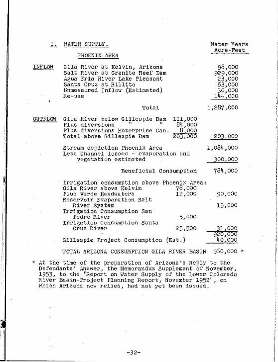
L. \·IA'l'ER SUPPLY.
PHOENIX AREA
INFLOW Gila River at Kelvin, Arizona Salt River at Granite Reef Dam Agua Fria River Lake Pleasant Santa Cruz at Rillito Unmeasured Inflow (Estimated) Re-use
OUTFLOW
Total
Gila River below Gillespie Dam 111,000 84,000 8,000
203,000
Plus diversions " " Plus diversions Enterprise Can. Total above Gillespie Dam
Stream depletion Phoenix Area Less Channel losses - evaporation and
vegetation estimated
Beneficial Consumption
Irrigation consumption above Gila River above Kelvin Plus Verde Headwaters Reservoir Evaporation Salt
River System Irrigation Consumption san ·
Pedro River Irrigation Consumption Santa
Cruz River
Phoenix Area: 78,000 12,000
5,400
25 ,500
Gillespie Project Consumption (Est.)
TOTAL ARIZONA CONSUMPTION GILA RIVER BASIN
\>later Years Acre-Feet
98,000 929,000 23,000 63,000 30,000
144,000
1,287,000
203,000
1,084,000
300,000
784,000
90,000
15,000
31,000 920,000 40,000
960 ,000 *
*At the time of the preparation of Arizona's Reply to the Defendants' Answer , the Memorandum Supplement of November, 1953, to the "Report on vlater Supply of the Lower Colorado River Basin-Project Planning Report; November 1952" , on l~hich Arizona now relies , had not yet been issued.
-32-
i
I j i , j \ I
I

~ i
!. Ji
i!
ji
I '
I-2.
INFLOH
Salt R. at Gila R. Agua Fria R. Water Granite Reef at Years (Regula ted) Kelvin L.
1930 761 343 31 893 363 32 1516 366 33 888 373 34 862 220 35 1061 334 36 1056 302 37 1675 365 38 1251 234 39 767 157 40 659 224
Totals 11,389 3,281
11-Yr.Av. 1,035 298
Total reservoir capacity 3,000,000
INFLOW
Salt R. at Granite Reef, regul ated Gila R. at Kelvin, regulated Agua Fria at L. Pleasant, regulated Santa Cruz at Rillito Unmeasured Run-off (estimated)
Total
OUTFLOW
Gila R. at Gillespie Dam (above)
Depletion at Sites of Use
River-Channel Losses Estimated, data by U.S.G.S.
Man-made depletions, Phoenix Area
-33-
at Pleasant
34 103 84 33 14 79 24
115 29 30 10
555
50
acre-feet.
ou•rFLOh'
170 328 560 103
70 216 107 490 270 109
73
2,496
227
Acre -Feet 11-Yr. Av.
1,035,000 298,000 50,000 21,000 30,000
1,434,000
227,000
1,207,000
300,000
907,000
Dam

,.
1930-40 Period
Man-made Depletions. (Beneficial Consumptive Use) Based on C.U .rates ln 1952 Report, Bureau of Rec. Average Yearly
Acre-Feet
Gila River in New Mexico Duncan & Safford Valleys Ariz. San Pedro River Santa Cruz River in Mexico & Ariz. above Rillito Headwater Salt above Granite Reef Dam
" Verde " " Reservoir Evaporation in Ariz. (estimated)
Total above Phoenix area
Phoenix Area Depletions (Inflow Outflow Sheet 1)
Total
Man-made Depletions below Gillespie Dam (Gillespie & EnterpriBe Canals 17,000 a@ 3.5 : 60,000 A.F.)
Total Consumption Man-made
Less Depletions in New Mexico Mexico
Arizona Depletions Limit of Use
20,000 5,000
20,000 85,000 21,000 22,000
5,000 25.000 50,000
228,000
go~r ,ooo
1,135,000
60,000
1,195,000
25,000
1 ,170 ,000 *
* The State of Ari zona now relies upon the methods of calculation utilized by the Bureau of Reclamation in its Report on Hater Supply of the Lower Colorado River Basin-Project Planning Report, November, 1952, and the Memorandum Supplement thereto of November, 1953.
I-3. The la tes t map readi l y available reflects conditions
as of october 15, 1954 . No substantial change has occurred.
-34-

I.
~--------.l--------~1
- SALT AIV£A VALL£Y CRITICAL ARt A .
t .~'.ll.:;.; J CVtCN CAt£Ke$UP£R5TITION CRITICAL .1\RCA
w GI I.A•SANTA CRUZ CRITICA\. AREA
- £ LOY CRITICAL ARE:A
b~~%~1 MARAN_A CRITICAL AREA . .
- TUCSON CRIT ICAL AREA
e~~ SAHUARITA•CONTINENTAL CRITICAL." ARE ....
•• ..
10
••
•• •• 20
2 •
22 '
M E XICO
PORTION OF CENTRAL ARIZONA SHOWING CRITICAL AREA BOUNDARIES AS DESIGNATED
OCTOBER 15. 1954
f;ltOVHOW.t.TCR tiiVI SION - S'fAT[ L.AN O MPAR'rU[NT
CHI:c'"coL/...G.._ OC:T. 15, It~

I
I-4 (a)
TOTALS ORIGINAL ADDED AREA Acreage Sq.Mi. Acreage Sq.Mi. Acreage Sq.Mi
Salt River + 1,070,869 1673.2 * 968,2?0 1?12.9 146,131 228.3 -68.0 -43!?12
102,619 llii':3 Queen Creek + 321.012 ?01.6 * 187,399 292.8 133 .613 208.8 Gila-santa Cruz + 806,941 1260.8 * 494,008 771.8 312,933 489.0 Eloy + ?01,1.55 783.0 * 319,19? 498.7 181,960 284.3 Marana + 370,048 ?78.2 370,048 ?78.2 Tucson + 207,172 323.7 207,172 323 .7 Sahuarita-Continental + 193,087 301.7 193.087 ..lQbl
TOTAlS 3,470,284 ?422.2 1,968.8.52 3076.2 1,?01.432 2346.0
125 full Townships and 49 partial 'townships equal to 149 3/4 townships Total number of 1'wp in state 3360
Note : The above acreage is gross acreage and does not exclude roads, canals, ditches, etc. Also above figures ~re prepared by L.L. Lee, Zngineer, Groundwater Divn. State Land Dept. 10-1$-54.
Acreage in Proposed Critical Areas (Gross Figures)
I n the order shown above ~~ list the date of the establishment of each critical area the date established identified above by (*) or (+) accordingly - as follows:
Salt. River Valley - *Effective Date- September 1, 1951 + And effective Extended date lD-15-?4
Queen Creek - *Effective Date - January 16, 1951 + And effective ZXt ended date 10-15-54
Gila-santa Cruz - * Effective Date - June 19, 1951 + And effective Extended date 10-15-54
Eloy - * Effective Date - April 4, 1949 + And eff ective Extended date 10-1.5-54
Marana - + Effective Date - October 1.5, 1954 (New) . Tucson - + Effective Date - October 1.5, 1954 (New) Sahuarita-Continental - + Effective Date - October 15, 1954 (New)

(b) Information not readily available.
(c) Records of ground-water withdrawals qy critical areas not available.
(d) ... , -· •• - Pumpage, in acre-feet, from walls in principal ground-water areas in Arizona
Cochise County: San Simon Basin Willcox Basin Douglas Basin
Graham County: Cactus Flat Artesia area Safford Valley
Greenlee County: Duncan Valley
(Maricopa County: ( Salt River ( Valley Area ((Gila Bend area ( Dendora area (Pima County: ( Part of Santa ( Cruz River Basin (Pinal County: ( Part of Santa ( Cruz and Gila ( River Basin (Santa Cruz County: ( Part of Santa Cruz ( River Basin Yuma County: Dateland area Wellton-Mohawk
area South Gila ValleY
I_
1944
52,000
8,000
1945
9,000 8,000
1 iJ. ••
35,000
6,500
1946
5,800 15,500 12,500
5,600
1947
20,000 17,000
1948
23,000 22,000
us,ooo 100,000 llO,OOO
17,000 21,000 21,000
1949
28,000 30,000
40,000
ll,OOO
1,017,000 1,143,000 1,36o,ooo· 1,4o6,ooo 1,67o,ooo 1,644;ooo 33,300 40,500 60,800 67,000
106,COO
530,00
12,500
4,000
37,000 20,000
J . 6, 700 6, 700 1,900 5,000
111,000
610,000
18,500
4,000
35,000 22,000
-37-
1o8,ooo l45,ooo l45,ooo 150,oco
66o,ooo 70o,ooo 95o,ooo 1,1oo,ooo
.24,000
4,000
38,000 32,000
25,000
4,000
43,000 35,000
28,000
5,000
50,000 54,000
31,000
8,ooo
45,000 56,000

! !! . ~
~
I
I-4(d) Continued.
Pumpage, iQ ~op·~-faat, .from wells in principal ground-water areas in Arizona.
1950 1951 1952 1953 1954 Cochise County:
15,000 25,000 San Simon Basin 32,000 Willcox Basin 35,000 38,000 39,000 75,000 70,000 Douglas Basin 35,000 38,000 42,000 45,000 42,000
Graham County: Saf.ford Valley 90,000 125,000 70,000 120,000 90,000
Greenlee County: Duncan Valley 23,000 33,000 17,000 30,000 27,000
Maricopa County: Salt River Valley
1,852,000 1,910,000 2,000,000 area 2,300,000 2,300,000 Waterman Wash
area 28,000 30,000 Harquahala Plains
area 20,000 33,000 Gila Bend area 59,000 110,000 120,000 145,000 139,000 Dendora area 6,000 6,000 5,000 7,000
Pima County: Part o.f Santa Cruz
Basin 180,000 240,000 250,000 380,000 300,000 Pinal County: Part o.f Santa Cruz Basin and Gila River basin 1,000,000 1,030,000 950,000 1,400,000 1,200,000
Santa Cruz County: Part of Santa Cruz
Basin 21,000 30,000 27,000 27,000 20,000 ·. Yuma County:
15,000 26,000 47,000 Palomas Plain area 9,000 30,000 Wellton-Mohawk area 46,000 50,000 40,000 16,000 9,000 South Gila Valley 56,000 62,000 60,000 60,000 60,000 Northern Yuma County 28,000 26,000
(e) See answer to I-4(a).
(f) and (g). The in.formation is not readily available.
DATED: Narch 27, 1956.
Wayne M. Akin, Chairman Arizona Interstate Stream Co~~ission.
-38-