
An Assessment of Current Practices on Landslides Risk ...
12
GEOGRAFIA Online TM Malaysian Journal of Society and Space 13 issue 2 (1-12) © 2017, ISSN 2180-2491 1 An Assessment of Current Practices on Landslides Risk Management: A Case of Kuala Lumpur Territory Anas Alnaimat 1 , Lam Kuok Choy 2 , Mokhtar Jaafar 2 1 Environmental Management Programme, Faculty of Social Sciences and Humanities, Universiti Kebangsaan Malaysia, Bangi, 43600 Selangor, Malaysia 2 Social, Environmental and Developmental Sustainability Research Centre, Faculty of Social Sciences and Humanities, Universiti Kebangsaan Malaysia, 43600 Bangi, Selangor, Malaysia Correspondence: Anas Alnaimat ([email protected]) Abstract In Kuala Lumpur to date, there is little evidence to support landslide causes and very little research into the nature of landslide vulnerability. This article takes an interdisciplinary method and empirical approaches to examine, in addition where necessary, challenge a series of assumptions made regarding Landslide Risk Management (LRM) with a view to developing better understanding of social vulnerability on landslide hazard and its underlying causes alongside combine expert judgment on triggering factors. Moreover, the contribution of Malaysia Public Works Department (PWD/JKR) via the implication of National Slope Master Plan (NSMP 2009-2023) operational capabilities and its effectiveness on landslide risk mitigation measures is reviewed. The finding on the influence of landslide causative and triggering factors have shown steepness of slope was greatly functioned as a landslide primary causative factor on mass movement whereas, in Kuala Lumpur rainfall and human activities plays significant role in triggering landslide on a slope vulnerable to failure. The result suggests occupants of landslide prone areas have decent perceptions of landslide and its associated risk. Contrary wise, a loss of confidence by local residents on government authorities on implementing appropriate hazard mitigation measures, lack of voluntary data sharing and insufficiency public awareness campaigns conducted by Malaysian local authorities. Keywords: Kuala Lumpur, Landslide Risk Management (LRM), landslide vulnerability, National Slope Master Plan (NSMP), mitigation measures. Abstrak Di Kuala Lumpur sehingga kini, terdapat sedikit bukti kajian yang menyokong punca kejadian tanah runtuh dan kekurangan penyelidikan yang mengkaji sifat kerentanan tanah runtuh. Kajian ini mengambil pendekatan antara disiplin dan kaedah empirikal untuk memeriksa dan, sekiranya perlu, mencabar andaian-andaian yang dibuat dalam Pengurusan Risiko Tanah Runtuh (LRM) dengan tujuan untuk membentuk pemahaman yang lebih baik terhadap kerentanan sosial kepada bahaya tanah runtuh dan faktor penyebab asas, di samping menggabungkan pendapat pakar terhadap faktor pencetus. Selain itu, sumbangan Jabatan Kerja Raya Malaysia (JKR) menerusi Pelan Induk Cerun Negara (NSMP 2009-2023) serta implikasi ke atas keupayaan operasi dan keberkesanannya kepada langkah-langkah pengurangan risiko tanah runtuh turut disemak. Hasil kajian ke atas pengaruh faktor tanah runtuh dan faktor pencetus mendapati faktor kecuraman cerun merupakan faktor penyebab utama tanah runtuh, manakala di Kuala Lumpur hujan dan aktiviti manusia memainkan peranan penting dalam mencetuskan runtuhan di cerun berisiko. Hasil kajian turut menunjukkan penghuni di kawasan cenderung berlaku tanah runtuh mempunyai kesedaran dan persepsi risiko yang baik terhadap tanah runtuh dan risiko yang berkaitan. Sebaliknya, penduduk tempatan kehilangan keyakinan terhadap pihak berkuasa kerajaan untuk melaksanakan langkah-langkah mitigasi pengurangan bahaya ekoran kekurangan perkongsian data secara sukarela dan kekurangan kempen kesedaran awam yang dianjurkan oleh pihak berkuasa tempatan di Malaysia. Katakunci: Kuala Lumpur, Pengurusan Risiko Tanah Runtuh (LRM), kerentanan tanah runtuh, Pelan Induk Cerun Negara (NSMP), langkah mitigasi
Transcript of An Assessment of Current Practices on Landslides Risk ...
GEOGRAFIA OnlineTM
Malaysian Journal of Society and Space 13 issue 2 (1-12)
© 2017, ISSN 2180-2491 1
An Assessment of Current Practices on Landslides Risk Management: A Case of Kuala Lumpur Territory
Anas Alnaimat
1, Lam Kuok Choy
2, Mokhtar Jaafar
2
1Environmental Management Programme, Faculty of Social Sciences and Humanities, Universiti Kebangsaan Malaysia,
Bangi, 43600 Selangor, Malaysia 2Social, Environmental and Developmental Sustainability Research Centre, Faculty of Social Sciences and Humanities,
Universiti Kebangsaan Malaysia, 43600 Bangi, Selangor, Malaysia
Correspondence: Anas Alnaimat ([email protected])
Abstract In Kuala Lumpur to date, there is little evidence to support landslide causes and very little research into the
nature of landslide vulnerability. This article takes an interdisciplinary method and empirical approaches to
examine, in addition where necessary, challenge a series of assumptions made regarding Landslide Risk
Management (LRM) with a view to developing better understanding of social vulnerability on landslide hazard
and its underlying causes alongside combine expert judgment on triggering factors. Moreover, the contribution
of Malaysia Public Works Department (PWD/JKR) via the implication of National Slope Master Plan (NSMP
2009-2023) operational capabilities and its effectiveness on landslide risk mitigation measures is reviewed. The
finding on the influence of landslide causative and triggering factors have shown steepness of slope was greatly
functioned as a landslide primary causative factor on mass movement whereas, in Kuala Lumpur rainfall and
human activities plays significant role in triggering landslide on a slope vulnerable to failure. The result
suggests occupants of landslide prone areas have decent perceptions of landslide and its associated risk.
Contrary wise, a loss of confidence by local residents on government authorities on implementing appropriate
hazard mitigation measures, lack of voluntary data sharing and insufficiency public awareness campaigns
conducted by Malaysian local authorities.
Keywords: Kuala Lumpur, Landslide Risk Management (LRM), landslide vulnerability, National Slope Master
Plan (NSMP), mitigation measures.
Abstrak Di Kuala Lumpur sehingga kini, terdapat sedikit bukti kajian yang menyokong punca kejadian tanah runtuh dan
kekurangan penyelidikan yang mengkaji sifat kerentanan tanah runtuh. Kajian ini mengambil pendekatan antara
disiplin dan kaedah empirikal untuk memeriksa dan, sekiranya perlu, mencabar andaian-andaian yang dibuat
dalam Pengurusan Risiko Tanah Runtuh (LRM) dengan tujuan untuk membentuk pemahaman yang lebih baik
terhadap kerentanan sosial kepada bahaya tanah runtuh dan faktor penyebab asas, di samping menggabungkan
pendapat pakar terhadap faktor pencetus. Selain itu, sumbangan Jabatan Kerja Raya Malaysia (JKR) menerusi
Pelan Induk Cerun Negara (NSMP 2009-2023) serta implikasi ke atas keupayaan operasi dan keberkesanannya
kepada langkah-langkah pengurangan risiko tanah runtuh turut disemak. Hasil kajian ke atas pengaruh faktor
tanah runtuh dan faktor pencetus mendapati faktor kecuraman cerun merupakan faktor penyebab utama tanah
runtuh, manakala di Kuala Lumpur hujan dan aktiviti manusia memainkan peranan penting dalam mencetuskan
runtuhan di cerun berisiko. Hasil kajian turut menunjukkan penghuni di kawasan cenderung berlaku tanah
runtuh mempunyai kesedaran dan persepsi risiko yang baik terhadap tanah runtuh dan risiko yang berkaitan.
Sebaliknya, penduduk tempatan kehilangan keyakinan terhadap pihak berkuasa kerajaan untuk melaksanakan
langkah-langkah mitigasi pengurangan bahaya ekoran kekurangan perkongsian data secara sukarela dan
kekurangan kempen kesedaran awam yang dianjurkan oleh pihak berkuasa tempatan di Malaysia.
Katakunci: Kuala Lumpur, Pengurusan Risiko Tanah Runtuh (LRM), kerentanan tanah runtuh, Pelan Induk
Cerun Negara (NSMP), langkah mitigasi

GEOGRAFIA OnlineTM
Malaysian Journal of Society and Space 13 issue 2 (1-12)
© 2017, ISSN 2180-2491 2
Introduction Landslide is one of the natural hazards disasters, and it is one of the many natural processes that shape
the surface of the earth (Matebie et al., 2015; Reichenbach et al., 2014). Landslides phenomenon is
treated as just a natural process disturbing the environment, however when it occurs in populated
regions it will become a serious matter to investigate (Toshiyuki et al., 2008). Recently there have
been many occurrences of landslides in Malaysia, some of them are fatal or with serious
consequences. Most of these landslides have occurred on cut slopes or on embankments alongside
roads and highways in mountainous areas (Low and Faisal, 2012), as well as a vast number of these
landslides occurred near high-rise apartments and in residential areas. In Malaysia landslides and
floods are two major natural disasters that have impacted the country in terms of injuries, deaths,
property damage, disruption and destruction of services, public inconvenience and economic as well
as financial losses (Ibrahim et al., 2011).
However the aptitude of the geotechnical profession to formulate reliable predictions for slope
failures/stability remains deprived (Gue and Wong, 2012). This is principally due to the copious
sources of uncertainty faced by geotechnical engineering. Intrinsic natural unpredictability of soil
properties, lack of data, restrictions of models and above all human uncertainties are some of the
challenges that geotechnical engineers have to deal with (Qasim et al., 2013). Despite all of the
advance methods and techniques in spatial prediction of landslides, it is extremely difficult to predict
landslide hazards in absolute terms (Oven, 2009).
Sufficient understanding of landslide processes does exist to enable researchers to make an
estimation of landslide hazard potential, whereby experts can use this estimation to make certain
decisions regarding site suitability, causal and triggering factors of landslides, type of development,
and appropriate mitigation measures. According to Pauline (2012), evaluation research is necessary to
establish the effectiveness of public affairs programs and their contribution to organizational
effectiveness. It provides the vital information necessary to plan public relation actions.
Significance of the Research Recent advances methods and techniques such as GIS & Remote Sensing in risk analysis and risk
assessment are beginning to provide systematic processes to formalize slope-engineering practice and
enhance slope management (Dai et al., 2002). In recent years, risk analysis and management has
become an important tool in addressing uncertainty inherent in landslide hazards. The advanced
multivariate techniques proved to be effective in spatial prediction of landslides with high degree of
accuracy. Physical process based models also perform well in hazards mapping even in the areas with
poor database. Multi-criteria decision making approach also play significant role in determining
relative importance of landslide causative factors in slope instability study (Pardeshi et al., 2013).
As often is the case in landslide management, planning studies, nevertheless, are often linked
between scientific information and the general development planning process (Jasmi, 1996; Farisham,
2007). Failure to consider all of the natural hazards in the development planning process will result
eventually in the loss of lives, bodily injuries, property damage, critical facility failures, and
disruption of important economic activities (Tareq et al., 2012; Jamilah et al., 2014). The objectives of
this study are: i) to explore the perception of scientists, experts and Geo-technical engineers at various
government agencies on landslide triggering factors, implementation and risk management as well as
the effectiveness of Malaysia National Slope Master Plan (NSMP 2009-2023). Secondly, to
investigate local residents’ understanding of hazard impact and the catastrophic consequences of
landslide occurrences as well as to further inspect on socio-economic activities on the effects of
landslide occurrences in the Federal Territory of Kuala Lumpur and its surrounding suburbs.

GEOGRAFIA OnlineTM
Malaysian Journal of Society and Space
© 2017, ISSN 2180-2491
Materials and Methods Study Area
The study area, the Federal Territory of Kuala Lumpur, is located within the Klang valley in the state
of Selangor bordered by the Titiwangsa Mountains
approximately 243.6 sq km with a pop
(2012) the temperature in Kuala Lumpur remains at a fairly constant 28
normal for a tropical country close to the equator and the average annual precipitation in Malaysia is
around 2000 mm to 2500 mm.
Figure 1. Geographical sketch and location of Kuala Lumpur
Sociological Survey
Research data is collected on the variables by using quantitative data collection techniques, which was
prepared to measure the variables of this study. Two
administered to the local population and expert community respectively. The questionnaire set for the
local population is targeted at the respondent’s perception on their understanding of landslide, risk
concerns and landslide risk effect on property values, via prepared Likert scale Quintet with a series
of questions as well as ranking test, close
Whereas for the expert group,
ended and personal experts comments are conducted to obtain data for the variables on NSMP 2009
2023 as well as Public Works Department (PWD) operational capabilities, causative/triggering factors
(slope, rainfall, soil water saturation and human activitie
and government bodies that were
and Kuala Lumpur Territory.
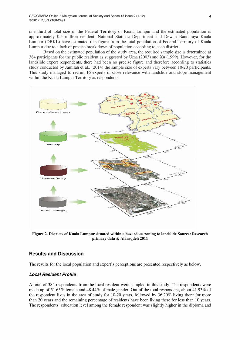
The study utilized simple random sampling technique and applied effectively to the
population of the study. The selected districts of study area are located in the northern part of the
Federal Territory of Kuala Lumpur, namely Titiwangsa, Setiawangsa, Wangsa Maju and Batu. The
selection of districts were determined according to a number of s
Satoshi et al., 2014) which have reported that these designated districts are located in landslide prone
areas and situated within a hazardous zoning (Figure 2). The chosen districts covers approximately
Journal of Society and Space 13 issue 2 (1-12)
The study area, the Federal Territory of Kuala Lumpur, is located within the Klang valley in the state
Titiwangsa Mountains in the east (Figure 1). The study area covers
approximately 243.6 sq km with a population of 1.7 million as of 2015. According to World
(2012) the temperature in Kuala Lumpur remains at a fairly constant 28-32 °C all year round, as is
normal for a tropical country close to the equator and the average annual precipitation in Malaysia is
Geographical sketch and location of Kuala Lumpur
Research data is collected on the variables by using quantitative data collection techniques, which was
prepared to measure the variables of this study. Two set of questionnaire were prepared and
administered to the local population and expert community respectively. The questionnaire set for the
local population is targeted at the respondent’s perception on their understanding of landslide, risk
landslide risk effect on property values, via prepared Likert scale Quintet with a series
of questions as well as ranking test, close-ended and open-ended questions.
for the expert group, a distributed questionnaire together with close
ended and personal experts comments are conducted to obtain data for the variables on NSMP 2009
2023 as well as Public Works Department (PWD) operational capabilities, causative/triggering factors
(slope, rainfall, soil water saturation and human activities) were examined via the relevant authorities
that were involved with risk reduction and slope management in Malaysia
The study utilized simple random sampling technique and applied effectively to the
lation of the study. The selected districts of study area are located in the northern part of the
Federal Territory of Kuala Lumpur, namely Titiwangsa, Setiawangsa, Wangsa Maju and Batu. The
selection of districts were determined according to a number of studies (Alaraqdeh, 2011; NST, 2008;
Satoshi et al., 2014) which have reported that these designated districts are located in landslide prone
areas and situated within a hazardous zoning (Figure 2). The chosen districts covers approximately
3
The study area, the Federal Territory of Kuala Lumpur, is located within the Klang valley in the state
in the east (Figure 1). The study area covers
as of 2015. According to World-weather
32 °C all year round, as is
normal for a tropical country close to the equator and the average annual precipitation in Malaysia is
Research data is collected on the variables by using quantitative data collection techniques, which was
set of questionnaire were prepared and
administered to the local population and expert community respectively. The questionnaire set for the
local population is targeted at the respondent’s perception on their understanding of landslide, risk
landslide risk effect on property values, via prepared Likert scale Quintet with a series
a distributed questionnaire together with close-ended, open-
ended and personal experts comments are conducted to obtain data for the variables on NSMP 2009-
2023 as well as Public Works Department (PWD) operational capabilities, causative/triggering factors
s) were examined via the relevant authorities
involved with risk reduction and slope management in Malaysia
The study utilized simple random sampling technique and applied effectively to the
lation of the study. The selected districts of study area are located in the northern part of the
Federal Territory of Kuala Lumpur, namely Titiwangsa, Setiawangsa, Wangsa Maju and Batu. The
tudies (Alaraqdeh, 2011; NST, 2008;
Satoshi et al., 2014) which have reported that these designated districts are located in landslide prone
areas and situated within a hazardous zoning (Figure 2). The chosen districts covers approximately
GEOGRAFIA OnlineTM
Malaysian Journal of Society and Space 13 issue 2 (1-12)
© 2017, ISSN 2180-2491 4
one third of total size of the Federal Territory of Kuala Lumpur and the estimated population is
approximately 0.5 million resident. National Statistic Department and Dewan Bandaraya Kuala
Lumpur (DBKL) have estimated this figure from the total population of Federal Territory of Kuala
Lumpur due to a lack of precise break down of population according to each district.
Based on the estimated population of the study area, the required sample size is determined at
384 participants for the public resident as suggested by Uma (2003) and Xu (1999). However, for the
landslide expert respondents, there had been no precise figure and therefore according to statistics
study conducted by Jamilah et al., (2014) the sample size of experts vary between 10-20 participants.
This study managed to recruit 16 experts in close relevance with landslide and slope management
within the Kuala Lumpur Territory as respondents.
Figure 2. Districts of Kuala Lumpur situated within a hazardous zoning to landslide Source: Research
primary data & Alaraqdeh 2011
Results and Discussion The results for the local population and expert’s perceptions are presented respectively as below.
Local Resident Profile A total of 384 respondents from the local resident were sampled in this study. The respondents were
made up of 51.65% female and 48.44% of male gender. Out of the total respondent, about 41.93% of
the respondent lives in the area of study for 10-20 years, followed by 36.20% living there for more
than 20 years and the remaining percentage of residents have been living there for less than 10 years.
The respondents’ education level among the female respondent was slightly higher in the diploma and

GEOGRAFIA OnlineTM
Malaysian Journal of Society and Space 13 issue 2 (1-12)
© 2017, ISSN 2180-2491 5
bachelor category at 32.55%, compared to the male’s achievement of 22.66% in the same category.
The percentages of male respondents who obtained post graduated education is 17.19% compared
with 14.58% for the females. The female respondents who gained upper secondary school certificate
is 4.43% compared to 7.55% for males. Finally, 1.04% of male respondents obtained lower secondary
school level. In terms of spatial distribution of respondents, the majority percentages of respondent
lives in districts somewhere else near Kuala Lumpur (36.20%), Setiawangsa (18.49%), Titiwangsa
(17.45%), Batu (14.32%), and Wangsa Maju (13.54%).
Correlation Analysis
Table 2 illustrates a significant and positive relationship obtained between the independent variable
(understanding and risk concerns) and dependent variable of landslides risk management (LRM) R=
0.537 and positive relationship was obtained between independent variable (property values) and
dependent variable LRM R=0.310 for all independent variable correlation is significant at the 0.01
level (2-tailed). The results therefore implied whenever local understanding, risk concern and property
values are highly presented the LRM increasing trend impact towards LRM positive impact.
Table 2. Correlation of understanding, risk concerns and property values on LRM
Understanding
and risk
concerns
Property
values
LRM
Understanding
and risk concerns
Pearson Correlation 1 .300**
.537**
Sig. (2-tailed) .000 .000
N 384 384 384
Property values
Pearson Correlation .300**
1 .310**
Sig. (2-tailed) .000 .000
N 384 384 384
LRM
Pearson Correlation .537**
.310**
1
Sig. (2-tailed) .000 .000
N 384 384 384
* Correlation is significant at the 0.01 level (2-tailed).
Regression Analysis
Regression test between local understandings and risk concern on LRM shows analyzed results
indicated adjusted R2=0.287 between understanding and risk concern on LRM within local resident.
The results therefore implies that understanding and risk concern predicted at 28.7% in the variance of
LRM while other factor which were not considered in this study predicted 71.3%. The results also
shows The (Sig=.000) implies that understanding and risk concern was a significant predictor in the
variance of LRM, on the other hand (F=155.052, Sig=.000) the regression test concludes a significant
statistical effect upon local understanding and risk concern towards landslide hazard reduction within
the designated districts of Kuala Lumpur and its surrounding.
Landslide Influential Factors
The findings of the descriptive approach on the influence of landslide causative and triggering factors
have shown local respondents categorized human activities to be first on the list in terms of its
effectiveness in contributing to landslide occurrences in Kuala Lumpur Territory and its surrounding
areas. The human activities obtained highest percentage ranking (69.53%), followed respectively by
rainfall (68.75%) and slope (54.95%).
Conversely, the result shows soil water saturation factor plays a weak function and have low
impact on slope failure. As a consequence of this reference it is important to emphasize on this
noteworthy research finding point for the risk perception matching throughout Kuala Lumpur

GEOGRAFIA OnlineTM
Malaysian Journal of Society and Space 13 issue 2 (1-12)
© 2017, ISSN 2180-2491 6
inhabitants and experts of landslide. In contrary, the analysis determines a difference on the scale in
influencing ratio (Figure 3) leaded by human activities accompanied with rainfall and slope.
Figure 3. Local resident perception on landslide influence factors
Over the past decades landslide experts and scientific researchers have developed and created
very detailed landslide hazard mapping for many different parts in Malaysia and all its metropolitan
areas (Alaraqdeh, 2011) in addition to formulated a tremendous spatial database in accordance to
slope instability causative and triggering factors however it has been always scarcely when it comes
to perception of local resident within urban areas to be considered as an effective formula on the
analysis and evaluation of landslide causative, triggering factors or over risk practices and their
impact power upon its associated landslide occurrences. As a consequence of this, research paper has
taken social risk perception and preparedness into account that due several important considerations
such as decision makers need to understand how people think about and responds to risks.
The result shows Kuala Lumpur inhabitants assessed human activities as substantial causative
factor on slope failure this understanding helps improve risk assessment measures among many
parties. The finding is supported by recent studies and according to (Reichenbach et al., 2014; Blahut
et al., 2014) the influence of human-induced land use changes on slope stability have shown that in
populated areas or metropolitan cities such as Kuala Lumpur federal territory and its surroundings, the
impact of humans on the environment contributes significantly to the initiation and reactivation of
landslides vulnerability. However, as mentioned earlier not only engineering and scientific aspects
and technological approaches of hazards have to be considered and implemented. Therefore, result of
the present research comply with the concept of availability heuristic in order to extract a suggested
outcomes for local behave on risk practices and hazard understanding.
Experts Profile
The gender breakdown of the respondent in the expert group were equal for the male and female at
50%. In term of living period in Kuala Lumpur, majority percentage have been living there for more
than 20 years (37.5%), followed by between 10-20 years (25%) and 37.5% been living there for less
than 10 years. Vast majority of the respondents had working experience between 5-10 years
(43.75%). The educational level achieved by the respondents showed that 25% of the female obtained
69.53%• Human activities influence
68.75%
• Rainfall influence
54.95%
• Slope characteristics
27.60%
• Soil water saturation
1
2
4
3
GEOGRAFIA OnlineTM
Malaysian Journal of Society and Space 13 issue 2 (1-12)
© 2017, ISSN 2180-2491 7
bachelor degree and post-graduate degree respectively. Conversely, the male respondents having a
bachelor degree were 31.25% and post-graduate degree at 12.50%.
Multi-influence Factors on LRM The landslide triggering and causative factors have been key research focus that is important in
landslide hazard and risk management study. Thus investigating the triggering and causative factors is
a critical task in landslide assessment and management process, despite landslides is being influenced
by several preparatory and triggering elements, which vary significantly from region to region. It is
therefore difficult to determine weights for given parameters or which factor had triggered the event
upon the slope failure. However, this study would concentrate on slope, rainfall, human activities and
soil water saturation factors and that’s due to regional conditions for being located at a tropical
climate. The findings of landslide hazard triggering / causative factors shown human dumping of
waste and construction development works had ranked first and highest in agreement in regards with
causative and triggering factors of landslide hazard occurrence in Kuala Lumpur Territory
(Mean=4.43). The results implies the crucial influence of slope overloading by human dumping of
waste and construction development works specially when it occurs at urban and most populated city
in Malaysia, thus in Kuala Lumpur the scenario of risk in slope instability occurrence is catastrophic
and resulting in more complex consequences. Furthermore, the results indicate significant importance
for studying the underlying elements for causing and triggering landslide occurrences.
The analysis revealed the importance of descriptive statistics that carried out by deductive
statistics approach, ie. through univariate analysis, which involves describing the distribution of a
single variable, including its central tendency on landslide causative and triggering factors. Thus
finding shows slope features and steepness to be most relevant causative factors influencing the mass
movements on slope failure occurrences in the study area. Therefore slope characteristics have been
classified as an essential parameter that causing landslide tragedies at Kuala Lumpur’s hillsides
developing districts. However, human activities and rainfall have been ranked as much important as
slope but within different approach by being primary triggering factors that made the slope vulnerable
to failure. It was clear that rainfall, human activities and slope instability influence distribution and
result shows the study area should include engineering consideration to reduce these factors influence
of landslide hazards (Figure 4).

GEOGRAFIA OnlineTM
Malaysian Journal of Society and Space
© 2017, ISSN 2180-2491
Figure 4. Experts standpoint on
Undoubtedly field studies, experts and government authorities’ opinion
factors on identification of the effective factors and its ratio of influence on the landslides occurrence
(Capitani, 2014). However, this technique usually puts a large number of factors ahead of researcher
and by using all of those factors in the research process would impose certain constraints such as
precision in quality, time, efforts and high cost. Alternatively, the implementation of statistical
analysis and descriptive approach of landslides hazard occurrences on assessing the
they are related to the specified primary factors is an appropriate method for an accurate identification
of the factors with the greatest impact on LRM.
The significant findings obtained in this study is the impairment influence of soil w
saturation ratio on landslide hazard occurrences in comparison with the great effective role played by
the rest of variables; slope, rainfall and human activities in landslide occurrences and its associated
risk management measures. The outcome of exp
a landslide main causative factor on mass movement in Kuala Lumpur Territory and across Malaysia.
Whereas rainfall and human activities plays significant impact on triggering of landslides occurrences
however soil water saturation remains as inactive factor and demonstrates low effectiveness on slope
failure. Hence, the study suggested in accordance to the findings, further social perception and
geospatial data analysis on the contribution factor of soi
correlation on LRM to be undertaken.
NSMP Operational Capabilities The Malaysia Public Works Department (PWD) operating performance and the National Slope
Master Plan (NSMP 2009-2023) were examined based on
mitigation strategies, workshops
Journal of Society and Space 13 issue 2 (1-12)
Experts standpoint on multi-influence factors on LRM
Undoubtedly field studies, experts and government authorities’ opinion are playing great key
factors on identification of the effective factors and its ratio of influence on the landslides occurrence
(Capitani, 2014). However, this technique usually puts a large number of factors ahead of researcher
factors in the research process would impose certain constraints such as
precision in quality, time, efforts and high cost. Alternatively, the implementation of statistical
analysis and descriptive approach of landslides hazard occurrences on assessing the
they are related to the specified primary factors is an appropriate method for an accurate identification
of the factors with the greatest impact on LRM.
The significant findings obtained in this study is the impairment influence of soil w
saturation ratio on landslide hazard occurrences in comparison with the great effective role played by
the rest of variables; slope, rainfall and human activities in landslide occurrences and its associated
risk management measures. The outcome of expert judgment reveals steepness of slope functioned as
a landslide main causative factor on mass movement in Kuala Lumpur Territory and across Malaysia.
Whereas rainfall and human activities plays significant impact on triggering of landslides occurrences
however soil water saturation remains as inactive factor and demonstrates low effectiveness on slope
failure. Hence, the study suggested in accordance to the findings, further social perception and
geospatial data analysis on the contribution factor of soil water saturation on landslide hazard and its
correlation on LRM to be undertaken.
NSMP Operational Capabilities
The Malaysia Public Works Department (PWD) operating performance and the National Slope
2023) were examined based on current status, needs and constraints,
workshops attendance, frameworks and operational capabilities, risk map
8
influence factors on LRM
are playing great key
factors on identification of the effective factors and its ratio of influence on the landslides occurrence
(Capitani, 2014). However, this technique usually puts a large number of factors ahead of researcher
factors in the research process would impose certain constraints such as
precision in quality, time, efforts and high cost. Alternatively, the implementation of statistical
analysis and descriptive approach of landslides hazard occurrences on assessing their ratio and how
they are related to the specified primary factors is an appropriate method for an accurate identification
The significant findings obtained in this study is the impairment influence of soil water
saturation ratio on landslide hazard occurrences in comparison with the great effective role played by
the rest of variables; slope, rainfall and human activities in landslide occurrences and its associated
ert judgment reveals steepness of slope functioned as
a landslide main causative factor on mass movement in Kuala Lumpur Territory and across Malaysia.
Whereas rainfall and human activities plays significant impact on triggering of landslides occurrences
however soil water saturation remains as inactive factor and demonstrates low effectiveness on slope
failure. Hence, the study suggested in accordance to the findings, further social perception and
l water saturation on landslide hazard and its
The Malaysia Public Works Department (PWD) operating performance and the National Slope
current status, needs and constraints,
frameworks and operational capabilities, risk map
GEOGRAFIA OnlineTM
Malaysian Journal of Society and Space
© 2017, ISSN 2180-2491
creation and future enforcement of planning obligations. Figure 5
restatement of main points for NSMP’s o
Figure 5.
The research indicates significant role play by the Malaysian PWD and other stakeholders on
both variables of risk management and the implementation of NSMP 2009
operation and mitigation measures on landslide hazard management and its
risk impacts in Malaysia and particularly for Kuala Lumpur Territory.
The results also revealed high agreement (81.25%
expert’s respondents towards NSMP 2009
strategic directions, action plans and key performance indicator measures, the NSMP 2009
would indeed help planners and decision makers for setting priorities on what needs to be done to
stem the increasing tide of landslides h
Nevertheless, despite the promising outcomes of this evaluation on the effectiveness and
implementation capabilities of NSMP 2009
terms of the abundant threats and risks facing people and as a result, are seldom a priority concern due
to lack of voluntary data sharing between government parties and public residents, insufficiency in
public awareness campaigns and programs set and lead by t
sectors. This is in line with the outcomes from the local perception which shows loss of confidence by
the community when it comes to government bodies such PWD or Malaysia Slope
Journal of Society and Space 13 issue 2 (1-12)
creation and future enforcement of planning obligations. Figure 5 illustrates
NSMP’s operational capabilities & effectiveness.
Figure 5. Operational capabilities & effectiveness of NSMP
The research indicates significant role play by the Malaysian PWD and other stakeholders on
both variables of risk management and the implementation of NSMP 2009-2023 for an effective
operation and mitigation measures on landslide hazard management and its associated environmental
risk impacts in Malaysia and particularly for Kuala Lumpur Territory.
The results also revealed high agreement (81.25%), which implies strong satisfaction from
expert’s respondents towards NSMP 2009-2013 comprehensive plans and effectiveness. Thus such
strategic directions, action plans and key performance indicator measures, the NSMP 2009
would indeed help planners and decision makers for setting priorities on what needs to be done to
stem the increasing tide of landslides hazardous events in Malaysia and Kuala Lumpur in particular.
Nevertheless, despite the promising outcomes of this evaluation on the effectiveness and
implementation capabilities of NSMP 2009-2023, the study indicated landslides are contextualized in
of the abundant threats and risks facing people and as a result, are seldom a priority concern due
to lack of voluntary data sharing between government parties and public residents, insufficiency in
public awareness campaigns and programs set and lead by the Malaysian PWD and its related private
sectors. This is in line with the outcomes from the local perception which shows loss of confidence by
the community when it comes to government bodies such PWD or Malaysia Slope
9
illustrates a summary and
The research indicates significant role play by the Malaysian PWD and other stakeholders on
2023 for an effective
associated environmental
implies strong satisfaction from
ffectiveness. Thus such
strategic directions, action plans and key performance indicator measures, the NSMP 2009-2023
would indeed help planners and decision makers for setting priorities on what needs to be done to
azardous events in Malaysia and Kuala Lumpur in particular.
Nevertheless, despite the promising outcomes of this evaluation on the effectiveness and
2023, the study indicated landslides are contextualized in
of the abundant threats and risks facing people and as a result, are seldom a priority concern due
to lack of voluntary data sharing between government parties and public residents, insufficiency in
he Malaysian PWD and its related private
sectors. This is in line with the outcomes from the local perception which shows loss of confidence by
the community when it comes to government bodies such PWD or Malaysia Slope-Engineering

GEOGRAFIA OnlineTM
Malaysian Journal of Society and Space 13 issue 2 (1-12)
© 2017, ISSN 2180-2491 10
Branch (CKC) on doing their tasks accordingly and effectively in terms of landslide hazard
assessment, risk management and mitigation measures.
Significance of Specific Findings This paper has examined local population’s perception on landslide risk and evaluated the experts of
government authorities’ view on hazard practices, assessment and Landslide Risk Management
(LRM) in the Territory of Kuala Lumpur. Research findings have challenged a number of
assumptions made in the context of LRM. In particular, the study has highlighted the changing
patterns of risk assessment and management associated with landslide events and the occupation of
landslide prone areas in Kuala Lumpur and its surrounding suburbs. Research highlights the benefits
of interdisciplinary approach, empirical evidence and descriptive analysis. Therefore, focusing on the
physical hazard alone does not explain why people choose to reside within landslide prone areas or
the factors giving rise to their vulnerability. In like manner, a social science based approach may
mitigate the landslide risk altogether and thus fail to consider the potential for a future landslide fatal
event.
The objectives for the assessment of landslide occurrences and its associated risk practices at
different levels could be analyzed and discussed in more detail. Experts on disaster management,
social and earth science scientists should be able to come up with better definition on what should be
expected from the results on landslide hazard management. Besides, social sciences could virtually
improve and present risk assessment methods, particularly by evaluating the tolerance and consent of
the landslide risk measures via Public Works Department (PWD) and/or relevant stakeholders.
Kuala Lumpur residents’ perceptions and risk concerns to landslide hazard are explored in
detail. Research findings emphasize on community concerns with short-term standpoints over long-
term risk mitigation measures. However, local resident react to landslides events as and when they
occur. Sad to say participants noted the absence of relevant government authorities in landslides risk
management activities. National institutions and expert’s practices on landslide risk assessment and
management in Kuala Lumpur and Malaysia actively engaged in development and, to some extent,
disaster management activities through the establishment of CKC, JKR and via the implementation of
NSMP 2009-2023. Conversely, for the local resident themselves, their priorities are large-scale
education campaign, awareness raising programs, livelihoods and resources in social environmental
contexts.
Conclusion
This study focused on the local populations’ understandings, perception of risk concerns and the role-
play of PWD by the means of the effectiveness on NSMP 2009-2023 on LRM. The findings strongly
suggested that occupants of landslide prone areas having a decent perception of understanding on
landslide hazard management and its associated risks. In accordance of the significant interaction
between local understanding, risk perception and landslide risk management, the study shows that
respondents situated with urban residential zones scored higher in risk perception and decent
landslides hazards understanding compared to respondents who live in outskirts or provinces area.
This could be the result of higher chance from gaining better educational level and other
socioeconomic contributing factors.
For an outsider, it can be difficult to comprehend that Kuala Lumpur residents willingly settle
in areas at risk from catastrophic landslide hazards. However landslide risk emerges not just from
societal marginalization but also from situations of relative prosperity and social growth. People want
to live by the road or as close as possible to amenities, in which the majority has been successful in
doing so, despite the coincidence of these areas with high probability of slope instability. Hence, it
requires a crucial role from the Ministry Of Works, PWD and Slope-Engineering Branch (CKC) for
an ultimate early warning system, hazards mitigation measures, and immediate field implementation.
It is because the study have shown strong indication and believes that social and economic losses
GEOGRAFIA OnlineTM
Malaysian Journal of Society and Space 13 issue 2 (1-12)
© 2017, ISSN 2180-2491 11
associated with landslide hazard occurrence can be monitored, controlled and mitigated by means of
effective assessment, planning and management.
References Alaraqdeh Anas (2011) Landslide hazard and risk mapping using remote sensing and GIS techniques.
Academic Publishing Germany: Lap Lambert.
Blahut J, Glade T, Sterlacchini S (2014) Debris flows risk analysis and direct loss estimation: the case
study of Valtellina di Tirano, Italy. Journal of Mountain Science (11), 288-307.
Capitani Marco, Adriano Ribolini, Monica Bini (2014) The slope aspect: A predisposing factor for
landsliding. Comptes Rendus Geosciences Published By Elsevier Masson (345), 427-438.
Department of statistics Malaysia (2016) National Summary Data Page 2012–2016. Adjusted
Population and Housing Census of Malaysia doc. 2010.
Gue SS, Wong S (2012) How to improve slope management and slope engineering practices in
Malaysia. Gue & Partners Sdn Bhd. Malaysia Geotechnical Engineering on 9/8/2012.
Ibrahim Komoo, Sarah Aziz, Lim Choun Sian (2011) Incorporating the Hyogo Framework for Action
into landslide disaster risk reduction in Malaysia. Bulletin of the Geological Society of
Malaysia (57), 7-11.
Jamilah Ahmad, Habibah Lateh, Saifudin Saleh (2014) Landslide hazards: household vulnerability,
resilience and coping in Malaysia, Journal of Education and Human Development 3(3), 149-
155.
Landslide Report (2012) The National Slope Master plan in Malaysia. [Cited 22 April 2015.
Available from: http://blogs.agu.org/landslideblog/2012/11/07/the-national-slope-masterplan-
in-malaysia.
Low Tian Huat, Faisal Ali (2012) Slope Hazard Assessment in Urbanized Area, EJGE (17), bund C.
Matebie Meten, Netra Prakashbhandary, Ryuichi Yatabe (2015) Effect of landslide factor
combinations on the prediction accuracy of landslide susceptibility maps in the Blue Nile
gorge of central Ethiopia. Journal of Geo-environmental Disasters (2), 9.
NST (2008) Bukit Antarabangsa Landslide and Landslide disaster in Damansara Photo Gallery.
[Cited 20 November 2015]. Available from:
http://savebukitgasing.wordpress.com/author/savegasinghill.
Oven Katie Jane (2009) Landscape, Livelihoods and Risk: Community Vulnerability to Landslides in
Nepal. Durham theses, Durham University. Available at Durham E-Theses. Available from:
http://etheses.dur.ac.uk/183/.
Pardeshi SD, Autade SE, Pardeshi SS (2013) Landslide hazard Assessment: Recent Trends And
Techniques. SpringerPlus 2193-1801-2-523.
Pauline Leong, Pooi Yin, Kumutham Krishnan, Catherine Lee, Cheng Ean (2012) Evaluation
Research on Public Relations Activities among Public Relations Practitioners in Malaysian
Corporations: An Exploratory Study. SEARCH: The Journal of the South East Asia Research
Centre 4(1), 41-61.
Qasim ISH, Harahap SBS (2013) Causal Factors of Malaysian Landslides: A Narrative Study.
Research Journal of Applied Sciences, Engineering and Technology 5(7), 2303-2308.
Reichenbach C, Busca C, Mondini M Rossi (2014) The Influence of Land Use Change on Landslide
Susceptibility Zonation: The Briga Catchment Test Site Messina, Italy. Journal of
Environmental Management 54(6), 1372-1384.
Satoshi Murakami, Tay Lea Tien, Rohayu Bte Che Omar, Tomomi Nishigaya, Nazirah Aziza, R,
Roslan INZ, Baharuddin Habibah Hj. Lateh, Naoki Sakai (2014) Landslides Hazard Map in
Malay Peninsula by Using Historical Landslide Database and Related Information. Journal of
Civil Engineering Research 4(3A), 54-58.
Toshiyuki K, Yoshinori Y, Yasuhito S (2008) Landslide disasters and hazard maps along national
highways in Japan. East Asia Landslides Symposium, Seoul, Korea, May 22-23.
Uma Sekaran (2003) Research Method For Business: A Skill Building Approach. 4th edition. John
Wiley & Sons. NJ, USA.

GEOGRAFIA OnlineTM
Malaysian Journal of Society and Space 13 issue 2 (1-12)
© 2017, ISSN 2180-2491 12
Worldweather-2012. Kuala Lumpur Yearly Weather Summary. [Cited 04 March 2016] Available
from:http://www.worldweatheronline.com/Kuala-Lumpur-weather-averages/Kuala
Lumpur/MY.aspx.
Xu Gang (1999) Estimating Sample Size For A Descriptive Study. In: Quantitative Research Quirk’s
Marketing Research Review. June 1999. Article ID: 19990603