An Alpha-Shapes based Technique for Detecting...
5
International Journal of Computer Applications (0975 – 8887) Recent Innovations in Computer Science and Information Technology 17 An Alpha-Shapes based Technique for Detecting Boundaries of a Wireless Sensor Network Rajesh Sharma National Institute of Technology Hamirpur, Himachal Pradesh India Lalit Kumar Awasthi National Institute of Technology Hamirpur, Himachal Pradesh India Naveen Chauhan National Institute of Technology Hamirpur, Himachal Pradesh India ABSTRACT Nodes along the boundaries of a Wireless Sensor Network (WSN) play some other important roles in addition to their routine tasks. A prior knowledge of the WSN boundaries can effectively be utilized in numerous WSN aspects pertaining to mobile events, mobile nodes, geographic routing, shape and coverage maintenance, barrier coverage etc. In this paper, we present a localized method based on actual connectivity graph and nodes’ locations to detect the boundaries of a WSN. The proposed scheme does not make any idealistic assumption like Unit Disk Graph (UDG) model, uniform node deployment, or specific node degrees. The method is based on the idea of alpha-shapes – geometric structures used to capture the shapes formed by a set of points in space. With an appropriate value of alpha, alpha-shapes capture the meaningful boundaries of a point cloud. The value for the parameter alpha is computed locally by each node as 2 / where is the distance between the node and its farthest neighbor. The analytical and simulated results show the robustness of the proposed scheme under dynamic network conditions. General Terms Wireless Sensor Network Keywords Wireless sensor network, alpha-shape, boundary detection 1. INTRODUCTION A Wireless Sensor Network (WSN) is an ad-hoc wireless network formed by a multitude of nodes called sensor nodes, each equipped with microcontroller, sensors, short-range RF- transceiver, and powered by on-board limited energy supply [1]. Sensor nodes are unobtrusively deployed inside or near some phenomenon of interest and tasked to collaboratively gather relevant sensory data like temperature, pressure, humidity, light, sound etc. The sensory data gathered by the nodes is routed over multiple hops to a specially designated node called a sink node that acts as a gateway between the WSN and the end-user space. This emerging data acquisition paradigm is envisaged as a potential enabler for many applications. Some of the major application areas of WSNs are [7]: surveillance, environment monitoring, habitat monitoring, smart buildings, structural health monitoring, facility management, industrial process automation, precision agriculture, health-care, logistics, critical infrastructure protection, disaster relief etc. The nodes along the boundaries of a WSN are tasked with a few other important roles in addition to their normal role of sensing and communication. Various factors for extra importance of these nodes are: i) boundary nodes capture the map that represents significant features of the underlying environment like obstacles, buildings, terrain variations, physical boundaries etc., ii) nodes along the exterior boundary enable the detection of entry and exit events of a moving target in a barrier coverage, iii) interior boundaries provides a good approximation of the general health of the WSN in terms of sensing and connectivity coverage, iv) nodes on the boundaries are considered to be most suitable beacons for virtual coordinate constructions, and v) interior boundaries bound the routing voids present in the network. A prior knowledge of boundary nodes can be utilized in a number of ways in various WSN applications. 1.1 Importance of WSN boundaries Interior boundaries may denote clusters of failed nodes due to power depletion, external attack, or physical destruction caused by events like fire or structure collapse etc. [18]; and indicate the deployment of additional nodes. The dead-end situation in greedy forwarding is also attributable to concave formations at the boundaries of the network [5]. A prior knowledge about the boundaries can enable geographic routing to avoid or recover from dead-end situations. The intrusion detection and target tracking applications are more interested in the entry and exit events [4, 6] of an intruder through the boundaries of the monitored region. In node localization using virtual coordinates, it is assumed that the finest resolution in coordinates appear using a set of beacons that are farthest apart [3] i.e. on the boundary of the network. Mobile nodes may be benefited by the knowledge about the boundaries of obstacles present in the region [19]. The importance of boundary detection is therefore advocated by a variety of situations at both network and application levels, that may be benefited by such knowledge. Alpha shape (α-shape) [8] is a geometric structure used to capture the shape rendered by a set of points in space. For a disc of radius 1/, an α-shape is a graph consisting of nodes and joining edges that lie on the boundary of the discs that contain no other nodes in the network. With an appropriate value of α, α-shapes can capture the meaningful internal and external boundaries of given point cloud. α-shapes are extensively used in the field of geometric modeling, medical imaging, graphics, and molecular structure modeling. A WSN is often modeled as a geometric graph where vertices represent nodes and the edges represent the communication links between nodes. So, effectively a WSN is a candidate for another application of α- shapes. 2. RELATED WORK According to the taxonomy suggested by Wang et al. [9], the existing methods for boundary detection of sensor networks
Transcript of An Alpha-Shapes based Technique for Detecting...

International Journal of Computer Applications (0975 – 8887)
Recent Innovations in Computer Science and Information Technology
17
An Alpha-Shapes based Technique for Detecting
Boundaries of a Wireless Sensor Network
Rajesh Sharma National Institute of Technology Hamirpur, Himachal Pradesh
India
Lalit Kumar Awasthi National Institute of Technology Hamirpur, Himachal Pradesh
India
Naveen Chauhan National Institute of Technology Hamirpur, Himachal Pradesh
India
ABSTRACT
Nodes along the boundaries of a Wireless Sensor Network
(WSN) play some other important roles in addition to their
routine tasks. A prior knowledge of the WSN boundaries can
effectively be utilized in numerous WSN aspects pertaining to
mobile events, mobile nodes, geographic routing, shape and
coverage maintenance, barrier coverage etc. In this paper, we
present a localized method based on actual connectivity graph
and nodes’ locations to detect the boundaries of a WSN. The
proposed scheme does not make any idealistic assumption like
Unit Disk Graph (UDG) model, uniform node deployment, or
specific node degrees. The method is based on the idea of
alpha-shapes – geometric structures used to capture the shapes
formed by a set of points in space. With an appropriate value
of alpha, alpha-shapes capture the meaningful boundaries of a
point cloud. The value for the parameter alpha is computed
locally by each node as 2/𝑑 where 𝑑 is the distance between
the node and its farthest neighbor. The analytical and
simulated results show the robustness of the proposed scheme
under dynamic network conditions.
General Terms
Wireless Sensor Network
Keywords
Wireless sensor network, alpha-shape, boundary detection
1. INTRODUCTION A Wireless Sensor Network (WSN) is an ad-hoc wireless
network formed by a multitude of nodes called sensor nodes,
each equipped with microcontroller, sensors, short-range RF-
transceiver, and powered by on-board limited energy supply
[1]. Sensor nodes are unobtrusively deployed inside or near
some phenomenon of interest and tasked to collaboratively
gather relevant sensory data like temperature, pressure,
humidity, light, sound etc. The sensory data gathered by the
nodes is routed over multiple hops to a specially designated
node called a sink node that acts as a gateway between the
WSN and the end-user space. This emerging data acquisition
paradigm is envisaged as a potential enabler for many
applications. Some of the major application areas of WSNs
are [7]: surveillance, environment monitoring, habitat
monitoring, smart buildings, structural health monitoring,
facility management, industrial process automation, precision
agriculture, health-care, logistics, critical infrastructure
protection, disaster relief etc.
The nodes along the boundaries of a WSN are tasked with a
few other important roles in addition to their normal role of
sensing and communication. Various factors for extra
importance of these nodes are: i) boundary nodes capture the
map that represents significant features of the underlying
environment like obstacles, buildings, terrain variations,
physical boundaries etc., ii) nodes along the exterior boundary
enable the detection of entry and exit events of a moving
target in a barrier coverage, iii) interior boundaries provides a
good approximation of the general health of the WSN in terms
of sensing and connectivity coverage, iv) nodes on the
boundaries are considered to be most suitable beacons for
virtual coordinate constructions, and v) interior boundaries
bound the routing voids present in the network. A prior
knowledge of boundary nodes can be utilized in a number of
ways in various WSN applications.
1.1 Importance of WSN boundaries Interior boundaries may denote clusters of failed nodes due to
power depletion, external attack, or physical destruction
caused by events like fire or structure collapse etc. [18]; and
indicate the deployment of additional nodes.
The dead-end situation in greedy forwarding is also
attributable to concave formations at the boundaries of the
network [5]. A prior knowledge about the boundaries can
enable geographic routing to avoid or recover from dead-end
situations.
The intrusion detection and target tracking applications are
more interested in the entry and exit events [4, 6] of an
intruder through the boundaries of the monitored region.
In node localization using virtual coordinates, it is assumed
that the finest resolution in coordinates appear using a set of
beacons that are farthest apart [3] i.e. on the boundary of the
network.
Mobile nodes may be benefited by the knowledge about the
boundaries of obstacles present in the region [19].
The importance of boundary detection is therefore advocated
by a variety of situations at both network and application
levels, that may be benefited by such knowledge.
Alpha shape (α-shape) [8] is a geometric structure used to
capture the shape rendered by a set of points in space. For a
disc of radius 1/𝛼, an α-shape is a graph consisting of nodes
and joining edges that lie on the boundary of the discs that
contain no other nodes in the network. With an appropriate
value of α, α-shapes can capture the meaningful internal and
external boundaries of given point cloud. α-shapes are
extensively used in the field of geometric modeling, medical
imaging, graphics, and molecular structure modeling.
A WSN is often modeled as a geometric graph where vertices
represent nodes and the edges represent the communication
links between nodes. So, effectively a WSN is a candidate for
another application of α- shapes.
2. RELATED WORK According to the taxonomy suggested by Wang et al. [9], the
existing methods for boundary detection of sensor networks
International Journal of Computer Applications (0975 – 8887)
Recent Innovations in Computer Science and Information Technology
18
can be broadly classified into three categories: geometric
methods, statistical methods, and topological methods.
2.1 Geometric Methods Geometric methods are guided by the location information of
the nodes to detect the boundaries of the network. Fang et al.
[5] was one of the earliest to use geometric aspects of the
network to identify routing holes using a method called tent-
rule. The tent-rule identifies all unreachable regions w.r.t.
greedy forwarding assuming Unit Disk Graph (UDG) model
for node ranges. It works by sorting neighbors angularly about
a node. If the bisectors of edges to contiguous neighbors
intersect outside the range of the node, then the node is around
an unreachable region. Fayed et al.[10] proposed a localized
α-shape based boundary detection method by taking α as 2/𝑅
where 𝑅 is the normalized transmission range of the nodes.
Liu et al.[11] proposed Rolling-ball UDG boundary Traversal
(RUT) based on α-shape for finding the boundaries of WSN
for the purpose of recovering from dead-end during greedy
forwarding. Rührup et al. [2] also used the notion of α-shapes
to determine the next boundary node for recovering from
dead-end during greedy forwarding. These methods rely
heavily on the assumption of UDG model for node ranges,
which is often criticized to be too unrealistic in practice [12,
13, 20].
2.2 Statistical Methods The statistical methods are based on the probability
distribution of various network aspects. A boundary node is
identified based on some statistical properties under certain
prevailing conditions. The statistical data like node degrees
and path lengths are used to infer whether the node is an
interior or a boundary node. Fekete et al.[14] proposed a
solution to detect the boundary nodes based on the assumption
that the nodes are uniformly distributed over the deployment
field. The method is motivated by the fact that the average
node degree of an interior node is much higher as compared to
the nodes on the boundaries of the network. A suitable degree
threshold then can be used to identify the boundaries. Chen et
al. [16] improved the Fekete's work by extending the notion of
node degrees to 2-hop neighbors and achieved a better
detection rate especially in low-density networks. Fekete et al.
[15] proposed another statistical method based on the concept
of “restricted stress centrality” of nodes with the assumption
that each node sends a message to every other node along all
shortest paths. The restricted stress centrality is the measure of
the number of shortest paths going through the node. An
interior node tends to have a higher centrality as compared to
the nodes on the boundaries. This very property can then be
used to detect boundary nodes. The drawback of statistical
methods is the unrealistic assumptions about node
distributions, node degrees, and routing methods.
2.3 Topological Methods Topological methods rely on the information about actual
connectivity graph of the network to detect boundaries. Ghrist
et al. [14] proposed an algorithm that detects boundaries via
homology without any knowledge of sensor locations;
however, the algorithm assumes that the node ranges are discs
with precise radii. Funke [10] proposed a method to identify
boundaries by constructing iso-contours based on hop count
from a root node and identifying where the contours break.
The proposed method assumes UDG model of connectivity
and high node degrees. Kröller et al. [17] proposed a solution
that detects network boundaries by searching for special
combinatorial structures called flowers. The communication
ranges in this work are modeled by a quasi-unit disk graph
(qUDG) [20], with nodes 𝑢 and 𝑣 definitely connected if
𝑢𝑣 ≤ 1/ 2 and not connected if 𝑢𝑣 ≥ 1. The success of
this algorithm depends on the identification of at least one
flower structure, which may not always be present especially
in a sparse network. Wang et al. [9] proposed a topological
method to detect holes that is purely driven by the
communication graph only. The scheme constructs shortest
path trees by flooding packets throughout the network. The
“flow” of tree forks near a hole, continues along opposite
sides of the hole and then meets again past the hole. By
detecting the nodes where the shortest paths fork and meet,
the boundaries of the hole are detected.
The proposed scheme is motivated by the fact that the location
awareness is a fundamental requirement in many WSN
applications (e.g. tracking, monitoring etc.) where data
without information of its originating node is not as useful.
So, location information is inherently available at each node.
Instead of making any idealistic assumption about the
transmission ranges of the nodes, we use a loose notion of
locality in wireless communications – nearby nodes are
connected by direct communication links, and distant nodes
generally are not. We have used qUDG [20] model for
wireless connectivity while simulating our scheme. The
proposed method makes use of both geometric as well as
topological aspects of the nodes to detect the boundaries of
the network. The proposed method is based on the
connectivity graph and nodes’ locations information locally
available.
3. SYSTEM MODEL AND
TERMINOLOGY Sensor nodes are deployed randomly in a 2D Euclidean plane.
Presence of obstacles, environmental conditions, and other RF
impairments make the nodes’ ranges to deviate from the Unit
Disk Graph (UDG) model. The terrain variations, obstacles,
uneven node densities, node failures etc. give rise to the
formation of holes in the WSNs. The network thus formed is
modeled using a graph 𝒢(𝒱,ℰ), where 𝒱 ⊂ ℝ2, is the set of
vertices representing the sensor nodes and ℰ ⊂ 𝒱 × 𝒱 , is the
set of edges representing wireless links between the nodes.
The communication links are assumed to be symmetric, i.e. if
𝑢 is a neighbor of 𝑣 then 𝑣 is also a neighbor of 𝑢. The nodes
are aware of their locations in the form of their Cartesian
coordinates and completely devoid of any information other
than the locations of their immediate neighbors.
3.1 Alpha-shapes Given a set of points 𝒮 in a plane and 𝛼 ≥ 0, a point 𝑝 ∈ 𝒮 is
said to be an α-extreme if it sits on the boundary of a disc with
radius 1/𝛼 that contains no other point in 𝒮. Two neighbors 𝑢
and 𝑣 in the set 𝒮 that lie on the boundary of an empty disc of
radius 1/𝛼 are said to be α-neighbors. An α-shape is a graph
whose vertices are α-extremes and whose edges connect α-
neighbors.
Figure 1(c) depicts a set of points rendered as equivalent α-
shape by applying the empty disc condition between each pair
of points. When α approaches zero, the α-shape approximates
the boundary of the convex hull (Figure 1(b)) of the points,
and for a large value of α every point in the space is on the
boundary. So, a proper value of α (Figure 1(c)) is the key for
detection of meaningful boundaries.
International Journal of Computer Applications (0975 – 8887)
Recent Innovations in Computer Science and Information Technology
19
3.2 Applying α-shapes to WSNs The α-shape computation requires a global view of precise
points’ locations in space. However, the nodes beyond the
transmission range are not considered by a node during α-
shape computation. Hence, α-shape computation is very much
localized to 1-hop neighbors of a node. α-shape computation
is also immune to translations and rotations in space, hence is
applicable to absolute as well as relative coordinate systems
for the points. A WSN is often modeled as a geometric graph
where vertices represent nodes and the edges represent the
communication links between the nodes. In WSN
applications, it is impractical for a node to have information
about the global topology or nodes’ locations for entire
network. Further, the location information available at nodes
may be faulty due to localization errors. So, at first sight it
may appear that a WSN is not a potential candidate for α-
shape application. However, for a value of the radius of the
disc comparable to the transmission range, a node only needs
to consider its nearby neighbors for α-shape computations,
thereby relaxing the global view requirement. The localized
computation for determination of α-extremes is a property that
motivates the use of α-shapes in WSN applications.
4. α-SHAPES BOUNDARY DETECTION Each node maintains a vector 𝒩 of locations information of
its 1-hop neighbors. This information is utilized to perform
the computation of the parameter α and to test the condition of
α-shapes. If a node is able to identify at least one such disc
that satisfies the α-shape condition, it tags itself as a boundary
node. In presence of variable node ranges, it is challenging to
have an optimum value of α that can be applied throughout
the network. In this work we argue that it is not necessary to
have same value of α for each node in the WSN, rather a node
may determine its own value of α based on the local topology
and the locations of its 1-hop neighbors by taking the distance
to its farthest neighbor as an approximation of its range. The
value of α is computed as 2/d where d is the Euclidean
distance between the node and its farthest neighbor. The
choice of the value for α is motivated by the fact that four
circles of radius 2/d can fully cover a circle of radius d. It is
also argued in [21] that a ratio of 2 (≅ 40% variation)
between maximum and minimum transmission range of a
node is a good enough assumption for modeling range
variations. The presence of localization errors may affect the
working of the proposed method. Hence, for this study it is
assumed that localization errors are to the extent of only a
small fraction of the communication ranges of the nodes.
The algorithm for boundary detection is described below:
Ignoring isolated nodes: If a node does not have any
neighbor (i.e. 𝒩 u = ϕ) then it identifies itself as an isolated
node and need not to perform the disc test.
Computing α: A node u computes the Euclidean distances
between itself and all its neighbors, and selects the maximum
distance so obtained for computing the value of α. Let 𝒩 u be the set of neighbors of u, v be the farthest neighbor of u,
the Euclidean distance between u and v be uv , then α is
computed as:
α = 2
uv where v ∈ 𝒩 u ∧ uv = max
x∈𝒩 u ux
The value of α will vary from node to node, and this aspect of
the proposed algorithm makes it resilient to the variable
transmission ranges of nodes.
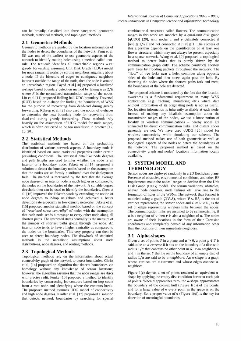
α-extreme detection: Based on the value of α, own location,
and locations of its neighbors, the node u(xu , yu) checks
whether it is an α-neighbor with any of its neighbors. The
condition for α-neighbor with a neighbor v(xv , yv ) is tested by
computing the center of the disc of radius 1/α passing through
u and v and applying the empty-disc test. The center of the
disc c(xc , yc) is calculated as (Figure. 2):
𝑥𝑐 ← 𝑥𝑢 + 𝑢𝑣
2cos 𝜃 − 𝑙 sin(𝜃)
𝑦𝑐 ← 𝑦𝑢 + 𝑢𝑣
2sin 𝜃 + 𝑙 cos(𝜃)
where r =1
α , 𝑙 = 𝑟2 −
𝑢𝑣
2
2
,𝜃 = tan−1 𝑦𝑢 − 𝑦𝑣𝑥𝑢 − 𝑥𝑣
,
and 𝑢𝑣 = 𝑥𝑢 − 𝑥𝑣 2 + 𝑦𝑢 − 𝑦𝑣
2
There will be two such discs (Figure. 2), one on either side of
the line joining the two nodes. If some of the neighbors of 𝑢
other than 𝑣, exist inside each of the discs then the node 𝑣 is
not an α-neighbor of 𝑢.
Figure 2. α-shape computation
Figure 1. (a) Given point cloud (b) Convex hull (𝜶 = 𝟎) (c) α-shape (𝜶 = 𝟐/𝒓)
International Journal of Computer Applications (0975 – 8887)
Recent Innovations in Computer Science and Information Technology
20
Given two neighbors 𝑢 and 𝑣, radius of the disc 𝑟, and centers
of the discs 𝑐1 and 𝑐2 passing through 𝑢 and 𝑣, the condition
given below determines whether 𝑢 and 𝑣 are not α-neighbors.
∃𝑤 ∈ 𝒩 𝑢 𝑐1𝑤 < 𝑟 ∧ ∃𝑥 ∈ 𝒩 𝑢 𝑐2𝑥 < 𝑟
If none of the neighbors of 𝑢 satisfies the condition in above
equation then nodes 𝑢 and 𝑣 are identified as α-neighbors and
included in the α-shape.
Boundary detection: A sequence of edges in the α-shapes of
adjacent nodes forms a boundary of the network. Each node
computes its local α-shape and thus is aware of its local
boundaries only. The boundary of the network is then
identified by sending probe packets through a sequence of
successively adjacent α-neighbor nodes.
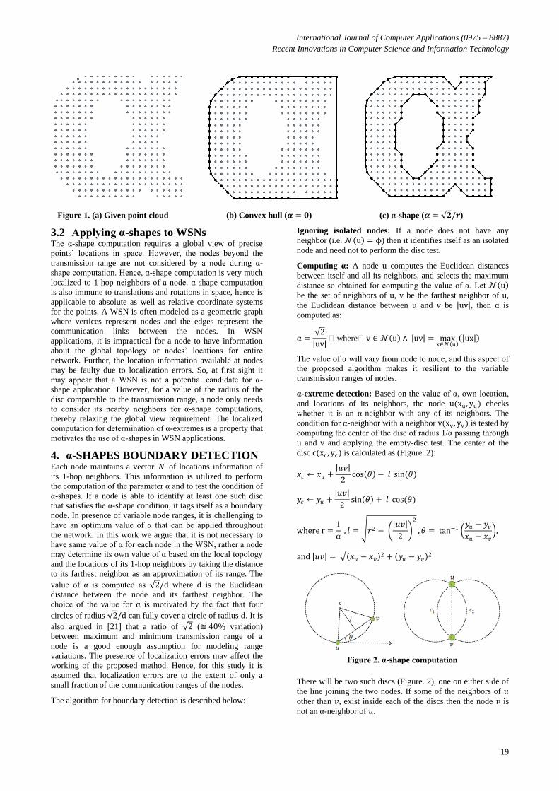
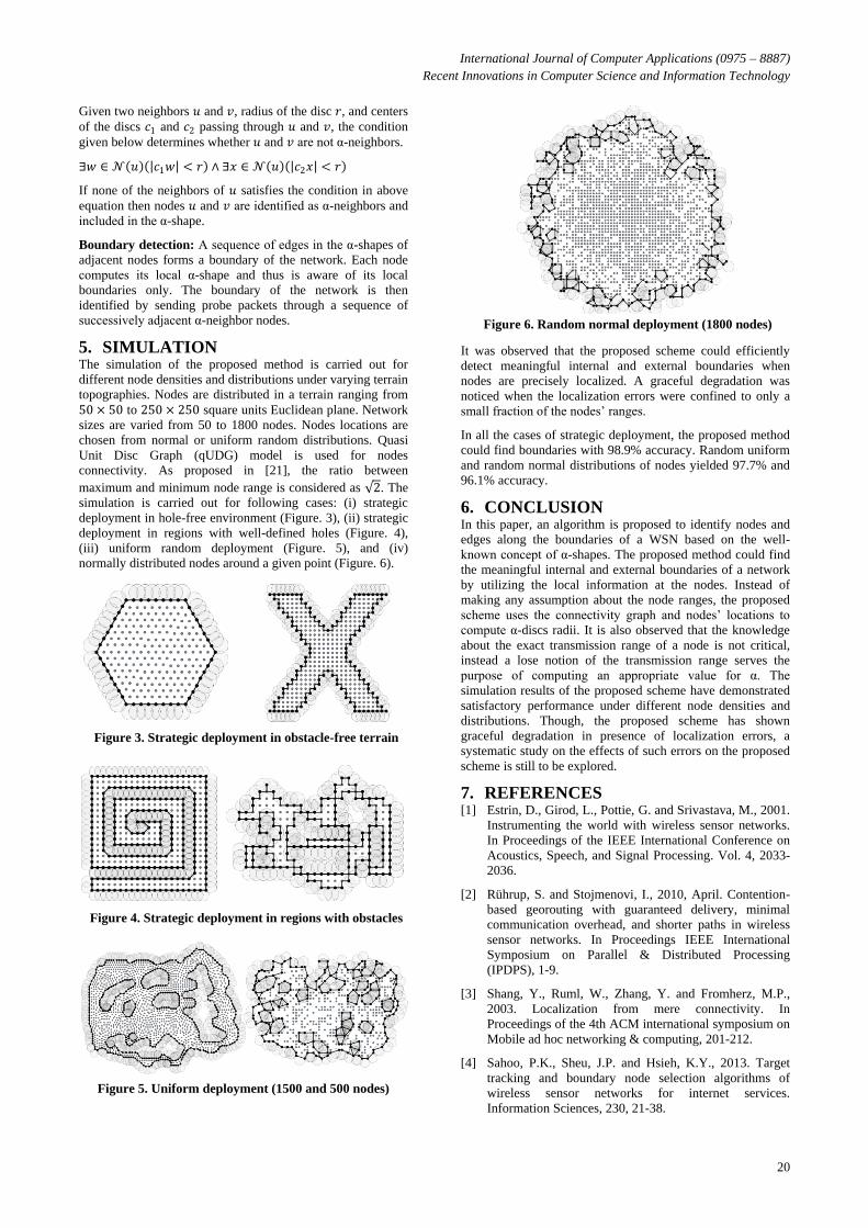
5. SIMULATION The simulation of the proposed method is carried out for
different node densities and distributions under varying terrain
topographies. Nodes are distributed in a terrain ranging from
50 × 50 to 250 × 250 square units Euclidean plane. Network
sizes are varied from 50 to 1800 nodes. Nodes locations are
chosen from normal or uniform random distributions. Quasi
Unit Disc Graph (qUDG) model is used for nodes
connectivity. As proposed in [21], the ratio between
maximum and minimum node range is considered as 2. The
simulation is carried out for following cases: (i) strategic
deployment in hole-free environment (Figure. 3), (ii) strategic
deployment in regions with well-defined holes (Figure. 4),
(iii) uniform random deployment (Figure. 5), and (iv)
normally distributed nodes around a given point (Figure. 6).
It was observed that the proposed scheme could efficiently
detect meaningful internal and external boundaries when
nodes are precisely localized. A graceful degradation was
noticed when the localization errors were confined to only a
small fraction of the nodes’ ranges.
In all the cases of strategic deployment, the proposed method
could find boundaries with 98.9% accuracy. Random uniform
and random normal distributions of nodes yielded 97.7% and
96.1% accuracy.
6. CONCLUSION In this paper, an algorithm is proposed to identify nodes and
edges along the boundaries of a WSN based on the well-
known concept of α-shapes. The proposed method could find
the meaningful internal and external boundaries of a network
by utilizing the local information at the nodes. Instead of
making any assumption about the node ranges, the proposed
scheme uses the connectivity graph and nodes’ locations to
compute α-discs radii. It is also observed that the knowledge
about the exact transmission range of a node is not critical,
instead a lose notion of the transmission range serves the
purpose of computing an appropriate value for α. The
simulation results of the proposed scheme have demonstrated
satisfactory performance under different node densities and
distributions. Though, the proposed scheme has shown
graceful degradation in presence of localization errors, a
systematic study on the effects of such errors on the proposed
scheme is still to be explored.
7. REFERENCES [1] Estrin, D., Girod, L., Pottie, G. and Srivastava, M., 2001.
Instrumenting the world with wireless sensor networks.
In Proceedings of the IEEE International Conference on
Acoustics, Speech, and Signal Processing. Vol. 4, 2033-
2036.
[2] Rührup, S. and Stojmenovi, I., 2010, April. Contention-
based georouting with guaranteed delivery, minimal
communication overhead, and shorter paths in wireless
sensor networks. In Proceedings IEEE International
Symposium on Parallel & Distributed Processing
(IPDPS), 1-9.
[3] Shang, Y., Ruml, W., Zhang, Y. and Fromherz, M.P.,
2003. Localization from mere connectivity. In
Proceedings of the 4th ACM international symposium on
Mobile ad hoc networking & computing, 201-212.
[4] Sahoo, P.K., Sheu, J.P. and Hsieh, K.Y., 2013. Target
tracking and boundary node selection algorithms of
wireless sensor networks for internet services.
Information Sciences, 230, 21-38.
Figure 6. Random normal deployment (1800 nodes)
Figure 5. Uniform deployment (1500 and 500 nodes)
Figure 4. Strategic deployment in regions with obstacles
Figure 3. Strategic deployment in obstacle-free terrain
International Journal of Computer Applications (0975 – 8887)
Recent Innovations in Computer Science and Information Technology
21
[5] Fang, Q., Gao, J. and Guibas, L.J., 2006. Locating and
bypassing holes in sensor networks. Mobile networks
and Applications, 11(2), 187-200.
[6] Kumar, S., Lai, T.H. and Arora, A., 2005, August.
Barrier coverage with wireless sensors. In Proceedings of
the 11th annual international conference on Mobile
computing and networking, 284-298).
[7] Akyildiz, I.F., Su, W., Sankarasubramaniam, Y. and
Cayirci, E., 2002. A survey on sensor networks. IEEE
communications magazine, 40(8), 102-114.
[8] Edelsbrunner, H., Kirkpatrick, D. and Seidel, R., 1983.
On the shape of a set of points in the plane. IEEE
Transactions on information theory, 29(4), 551-559.
[9] Wang, Y., Gao, J. and Mitchell, J.S., 2006. Boundary
recognition in sensor networks by topological methods.
In Proceedings of the 12th ACM annual international
conference on Mobile computing and networking, 122-
133.
[10] Fayed, M. and Mouftah, H.T., 2009. Localised alpha-
shape computations for boundary recognition in sensor
networks. Ad Hoc Networks, 7(6), 1259-1269.
[11] Liu, W.J. and Feng, K.T., 2009. Greedy routing with
anti-void traversal for wireless sensor networks. IEEE
Transactions on Mobile Computing, 8(7), 910-922.
[12] Kim, Y.J., Govindan, R., Karp, B. and Shenker, S., 2005.
Geographic routing made practical. In Proceedings of the
2nd conference on Symposium on Networked Systems
Design & Implementation, 2, 217-230).
[13] Kim, Y.J., Govindan, R., Karp, B. and Shenker, S., 2005.
On the pitfalls of geographic face routing. In Proceedings
of the 2005 joint workshop on Foundations of mobile
computing, 34-43.
[14] Fekete, S.P., Kröller, A., Pfisterer, D., Fischer, S. and
Buschmann, C., 2004. Neighborhood-based topology
recognition in sensor networks. In International
Symposium on Algorithms and Experiments for Sensor
Systems, Wireless Networks and Distributed Robotics,
123-136.
[15] Fekete, S.P., Kaufmann, M., Kröller, A. and Lehmann,
K., 2005. A new approach for boundary recognition in
geometric sensor networks. arXiv preprint cs/0508006.
[16] Chen, Y.H., Chung, W.H., Ni, G.K., Zhang, H. and Kuo,
S.Y., 2012. Optimal self boundary recognition with two-
hop information for ad hoc networks. In 2012 IEEE
Wireless Communications and Networking Conference
(WCNC) 1910-1914.
[17] Kröller, A., Fekete, S.P., Pfisterer, D. and Fischer, S.,
2006, January. Deterministic boundary recognition and
topology extraction for large sensor networks. In
Proceedings of the seventeenth annual ACM-SIAM
symposium on Discrete algorithm 1000-1009.
[18] Ahmed, N., Kanhere, S.S. and Jha, S., 2005. The holes
problem in wireless sensor networks: a survey. ACM
SIGMOBILE Mobile Computing and Communications
Review, 9(2), 4-18.
[19] Luo, R.C., Tu, L.C. and Chen, O., 2005. Auto-
deployment of mobile nodes in wireless sensor networks
using grid method. In 2005 IEEE International
Conference on Industrial Technology, 359-364).
[20] Kuhn, F., Wattenhofer, R. and Zollinger, A., 2003. Ad-
hoc networks beyond unit disk graphs. In Proceedings of
the 2003 joint workshop on Foundations of mobile
computing, 69-78.
[21] Barriere, L., Fraigniaud, P., Narayanan, L. and Opatrny,
J., 2003. Robust position‐based routing in wireless ad
hoc networks with irregular transmission ranges.
Wireless Communications and Mobile Computing, 3(2),
pp.141-153.
IJCATM : www.ijcaonline.org