CITY OF DENISON PLANNING AND ZONING COMMISSION MEETING AGENDA

AGENDA PLANNING AND ZONING COMMISSION
September 26, 2012 After determining that a quorum is present, the Planning and Zoning Commission will convene a Work Session on Wednesday, September 26, 2012 at 6:15 p.m. in the City Council Chambers at 215 E. McKinney Street, Denton, Texas at which time the following items will be considered: WORK SESSION
1. Clarification of agenda items listed in the Regular Session agenda for this meeting, and discussion of issues not briefed in the written backup materials.
2. Consider nominations and hold elections of the Planning and Zoning Commission Chair and Vice-Chair positions.
REGULAR MEETING The Planning and Zoning Commission will convene a Regular Meeting of the Planning and Zoning Commission of the City of Denton, Texas which will be held on Wednesday, September 26, 2012 and will begin at 6:30 p.m. in the City Council Chambers at City Hall, 215 E. McKinney at which time the following items will be considered: 1. PLEDGE OF ALLEGIANCE:
A. U.S. Flag B. Texas Flag “Honor the Texas Flag – I pledge allegiance to thee, Texas one state under God,
one and indivisible.”
2. THE SWEARING IN OF A NEW PLANNING AND ZONING COMMISSIONER: A. The Swearing-In Ceremony of Jim Strange.
3. CONSIDER APPROVAL OF THE PLANNING AND ZONING COMMISSION MINUTES FOR: A. September 12, 2012
4. CONSENT AGENDA: Staff recommends approval of the following items because they
meet the requirements of the Denton Development Code. Approval of the Consent Agenda includes staff recommendations for approvals and authorizes staff to proceed. The Planning and Zoning Commission has reviewed the applications and has had an opportunity to raise questions regarding the items prior to consideration:

Planning and Zoning Commission September 26, 2012 Page 2 of 3
A. Preliminary Plat of 118 single-family detached lots and 3 open space lots, being a replat of Lots 1 & 2, Block 1 of the Kenas Additions and unplatted property. The subject property is approximately 23.455 acres in size and is generally located south of Pockrus Page Road, east of the Interstate 35 frontage road and west of Cattail Lane the Gideon Walker Survey, Abstract No. 1330. The property is located within a Neighborhood Residential 6 (NR-6) zoning district. (PP12-0009, Glenwood Village Addition, Erica Marohnic)
B. Final Plat of The Preserve at Pecan Creek, Section N, Phase IIB. The approximately 7.003 acres property is located wholly west of Lakeview Boulevard, north of Desert Willow Drive and east and west of Glen Crest Lane within the Gideon Walker Survey, Abstract No. 1330. The property is located within The Preserve at Pecan Creek Planned Development (PD-142) zoning district. (FP12-0018, The Preserve at Pecan Creek, Section N, Phase IIB, Erica Marohnic)
5. PUBLIC HEARINGS:
A. Hold a public hearing and consider making a recommendation to City Council regarding the initial zoning of approximately 25.03 acres of land to the Industrial Center General (IC-G) zoning district. The subject property is located on the east side of Corbin Road, south of Shelby Lane. (Z12-0008, Corbin Road Business Park II, Cindy Jackson)
6. FUTURE AGENDA ITEMS: Under Section 551.042 of the Texas Open Meetings Act,
respond to inquiries from the Planning and Zoning Commission or the public with specific factual information or recitation of policy, or accept a proposal to place the matter on the agenda for an upcoming meeting.
7. ADJOURN
NOTE: THE PLANNING AND ZONING COMMISSION RESERVES THE RIGHT TO ADJOURN INTO A CLOSED MEETING AT ANY TIME REGARDING ANY ITEM ON THE AGENDA FOR WHICH IT IS LEGALLY PERMISSIBLE.
NOTE: THE CITY OF DENTON CITY COUNCIL ROOM IS ACCESSIBLE IN ACCORDANCE WITH THE AMERICANS
WITH DISABILITIES ACT. THE CITY WILL PROVIDE SIGN LANGUAGE INTERPRETERS FOR THE HEARING IMPAIRED IF REQUESTED AT LEAST 48 HOURS IN ADVANCE OF THE SCHEDULED MEETING. PLEASE CALL THE CITY SECRETARY'S OFFICE AT 349-8309 OR USE TELECOMMUNICATIONS DEVICES FOR THE DEAF (TDD) BY CALLING 1-800-RELAY-TX SO THAT A SIGN LANGUAGE INTERPRETER CAN BE SCHEDULED THROUGH THE CITY SECRETARY'S OFFICE.
Planning and Zoning Commission September 26, 2012 Page 3 of 3 CERTIFICATE
I certify that the above notice of meeting was posted on the bulletin board at the City Hall of the City of Denton, Texas, on the day of , 2012 at o'clock (a.m.) (p.m.) _____________________ CITY SECRETARY

1
MINUTES 1 PLANNING AND ZONING COMMISSION 2
September 12, 2012 3 4 After determining that a quorum was present, the Planning and Zoning Commission convened a 5 Work Session on Wednesday, September 12, 2012 at 6:15 p.m. in the City Council Chambers 6 at City Hall, 215 E. McKinney Street, Denton, Texas at which time the following items were 7 considered: 8 9 PRESENT: Chairman Jay Thomas. Commissioners: Brian Bentley, Devin Taylor, 10
Jessica King, Frank Conner, Thom Reece and Jean Schaake. 11 12 ABSENT: None. 13 14 STAFF: Athenia Green, Mark Cunningham, Brian Lockley, Aaron Leal, Cindy 15
Jackson, Nana Appiah, and John Cabrales. 16 17 WORK SESSION 18 19 1. Clarification of agenda items listed in the Regular Session agenda for this meeting, and
discussion of issues not briefed in the written backup materials. 20 Chairman Thomas called the Work Session to order at 6:17 p.m. 21 22 Jackson stated there were some typographical errors on a few of the Agenda items. Those 23 Agenda items are Consent Agenda items D and E, which stated the property is located on the 24 Southwest corner of Audra and Audra Lane, it should read the Southeast corner of Audra and 25 Audra Lane. 26 27 Chairman Thomas closed the Work Session at 6:21 p.m. 28 29 REGULAR MEETING 30 31 The Planning and Zoning Commission convened a Regular Meeting of the Planning and Zoning 32 Commission of the City of Denton, Texas which was held on Wednesday, September 12, 2012 33 and began at 6:30 p.m. in the City Council Chambers at City Hall, 215 E. McKinney at which 34 time the following items were considered: 35 36 Chairman Thomas called the Regular Meeting to order at 6:30 p.m. Chairman Thomas stated he 37 would like to welcome the new Commissioner Jessica King. 38 39 1. PLEDGE OF ALLEGIANCE: 40 A. U.S. Flag 41 42
DRAFT DRAFT
2
B. Texas Flag "Honor the Texas Flag - I pledge allegiance to thee, Texas one state under God,one and indivisible."
2 2. CONSIDER APPROVAL OF THE PLANNING AND ZONING COMMISSION
MINUTES FOR: 3 A. August 22, 2012 4 Commissioner Thom Reece motioned, Commissioner Frank Conner seconded to approve the 5 minutes. Motion approved (7-0). 6 7 Cunningham stated Agenda Item Z12-0005 was postponed during the August 22, 2012 meeting 8 and will not be held at this time. 9 10 3. CONSENT AGENDA: Staff recommends approval of the following items because they
meet the requirements of the Denton Development Code. Approval of the Consent Agendaincludes staff recommendations for approvals and authorizes staff to proceed. The Planningand Zoning Commission has reviewed the applications and has had an opportunity to raise questions regarding the items prior to consideration:
11 A. Preliminary Plat of Lots 1, Block A of the Tommy’s High-Tech Automotive Addition. The
subject property is approximately 2.36 acres in size and is generally located at the northwest corner of Lindsey Street and Fort Worth Drive (U.S. 377) within the Alexander Hill Survey,Abstract No. 623. The property is located within a Downtown Commercial General (DC-G) zoning district. (PP12-0007, Lots 1, Block A of the Tommy’s High-Tech Automotive Addition, Erica Marohnic)
12 B. Final Plat of Lots 1, Block A of the Tommy’s High-Tech Automotive Addition. The subject
property is approximately 2.36 acres in size and is generally located at the northwest cornerof Lindsey Street and Fort Worth Drive (U.S. 377) within the Alexander Hill Survey,Abstract No. 623. The property is located within a Downtown Commercial General (DC-G) zoning district. (FP12-0014, Lots 1, Block A of the Tommy’s High-Tech Automotive Addition, Erica Marohnic)
13 C. Conveyance Plat of the Ryan Companies Addition, Lots 2 and 4, Block B. The
approximately 36.188 acre property is located at southeast corner of the intersection ofAirport Road and Dakota Lane within the Robert Chowning Survey, Abstract No. 266, theJohn Davis Survey, Abstract No. 326, the O.S. Brewster Survey, Abstract No. 56 and theEugene Puchalski Survey, Abstract No. 996. The property is located within an Industrial Center General (IC-G) zoning district. (CV12-0002, Ryan Companies Addition, Cindy Jackson)
14 D. Preliminary Plat of the Denton Church of Christ Addition, Lots 1 and 2, Block A. The
approximately 9.521 acre property is located at southwest corner of the intersection ofAudra Lane and Audra Lane within the M.E.P & P.R.R. Co Survey, Abstract No. 1473 and

3
the M.E.P & P.R.R. Co Survey, Abstract No. 1479. The property is located within a Neighborhood Residential 2 (NR-2) zoning district. (PP12-0004, Denton Church of Christ Addition, Cindy Jackson)
1 E. Final Plat of the Denton Church of Christ Addition, Lot 1, Block A. The approximately
2.384 acre property is located at southwest corner of the intersection of Audra Lane andAudra Lane within the M.E.P & P.R.R. Co Survey, Abstract No. 1473 and the M.E.P &P.R.R. Co Survey, Abstract No. 1479. The property is located within a Neighborhood Residential 2 (NR-2) zoning district. (FP12-0006, Denton Church of Christ Addition, Cindy Jackson)
2 F. Final plat of Lot 7R1, 7R2 & 15R, Block 1 of the Golden Triangle Addition, being a replat
of Lot 7R of the Golden Triangle Addition. The 23.639 acre property is located northeast of the intersection of Loop 2008 and Interstate 35, south of San Jacinto Boulevard and west ofColorado Boulevard within the J.W. McGowan Survey, Abstract No. 797. The property is located within a Regional Center Commercial Downtown (RCC-D) zoning district. (FR12-0013, Golden Triangle Addition, Lot 7R, Erica Marohnic)
3 G. Final Plat of Lot 1R, Block A of the Denton County Law Enforcement Center Addition;
being a replat of Lot 1C-2 of the Adkisson Addition, Lot 1, Block 1 of the Denton CountyMaintenance Facility Addition, Lot 1, Block A of the Denton County Criminal JusticeFacility Addition and Lot 1A-5, Block 1 of the Adkisson Addition. The approximately 65.3853 acre property is generally located at the southwest corner of McKinney Street andWoodrow Lane Street. The property is located within a Commercial Mixed Use General(CM-G) zoning district. (FR12-0011, Denton County Law Enforcement Center, RonMenguita)
4 Commissioner Thom Reece motioned, Commissioner Jean Schaake seconded to approve the 5 Consent Agenda. Motion approved (7-0). 6 7 4. ITEMS FOR INDIVIDUAL CONSIDERATION: 8 A. Consider the approval of an Alternative Development Plan for a church located at 1510
Audra Lane. The 2.195 acre site is located at southwest corner of the intersection of AudraLane and Audra Lane. The property is located within a Neighborhood Residential 2 (NR-2) zoning district. (ADP12-0001, Denton Church of Christ, Cindy Jackson)
9 Jackson provided a brief background on this request. Jackson stated staff recommends approval 10 of this request. Jackson added the applicant is present. Bentley referred to the background 11 information which lists details on Phase I and Phase II; Bentley questioned if that includes 12 parking for Phase I and II, Jackson stated it includes the entire building as it is phased out. 13 Bentley questioned if it includes parking for Phase II, Jackson stated that is correct. Bentley 14 questioned which trees are considered parking lot trees, Jackson stated the trees located at the 15 front buffer. Bentley questioned if the parking lot is allowed to extend into the drainage 16 easement, Jackson stated this review has already been through the approval process. 17

4
1 Chris Seely, Allen & Ridinger Consulting, Inc. 2 550 S. Edmonds Lane, Suite 100, Lewisville, Texas 75067 3 4 Seely stated the dumpster will be gated as shown on the engineering plans which have been 5 submitted; however, those were not provided to this Commission. Seely stated he was unaware 6 the dumpster needed to be concealed from the public view. Seely added the drainage easement 7 area on the front of the property near the trees is the retention area; there will be curb cuts for the 8 drainage. 9 10 Commissioner Devin Taylor motioned, Commissioner Thom Reece seconded to approve this 11 request. Motion approved (6-1). 12 13 5. FUTURE AGENDA ITEMS: Under Section 551.042 of the Texas Open Meetings Act,
respond to inquiries from the Planning and Zoning Commission or the public with specific factual information or recitation of policy, or accept a proposal to place the matter on theagenda for an upcoming meeting.
14 Cunningham stated to add the nomination of Chair and Vice-Chair, and new training for the new 15 Commissioners. 16 17 6. ADJOURN 18 Chairman Thomas adjourned the meeting at 6:49 p.m. 19

PLANNING AND ZONING COMMISSION AGENDA INFORMATION SHEET
AGENDA DATE: September 26, 2012 DIVISION: Planning and Development CASE MANAGER: Cindy Jackson, 349-8351 SUBJECT – Corbin Road Business Park II (Z12-0008) Hold a public hearing and consider making a recommendation to City Council regarding the initial zoning of approximately 25.03 acres of land to the Industrial Center General (IC-G) zoning district. The subject property is located on the east side of Corbin Road, south of Shelby Lane. PROPOSAL/ BACKGROUND The applicant, Vickie Marriott (Corbin Realty II, L.P.), is requesting the initial zoning of the subject sites in order to develop the property. The site is comprised of two platted lots and two unplatted tracts which were a part of DH-3, an area which was annexed into the City in 2010. At the time of annexation, the site was given a “place holder” zoning designation of RD-5X. The subject lots/tracts are undeveloped at this time. The site was annexed into the City in May of 2010 as a part of the DH-3 area. The property is part of the Corbin Road Industrial Park Addition. The western portion of the subject site encroaches into the floodplain as shown on 2011 FEMA maps. Prior to development of this portion of the site, either a Letter of Map Revision (LOMR) or a Conditional Letter of Map Revision (CLOMR) must be approved by FEMA prior to the reclamation of any floodplain. Nine (8) public notices were sent to property owners within 200 feet of the subject site. Nineteen (19) courtesy notices were also sent to residents within 500 feet of this proposal. As of this writing, staff has received no written responses from property owners within the notification area. Public notification information is provided in Exhibit 6. PRIOR ACTION/REVIEW
• January 23, 2008, final plat of Lots 1-7, Block A, Corbin Road Industrial Park Phase I approved by P&Z
• May, 2010, site was annexed into the City.
OPTIONS 1. Recommend Approval as submitted.
2. Recommend Approval subject to conditions.
Public Hearing Item 5A

3. Deny.
4. Postpone consideration.
5. Table the item
RECOMMENDATION The Development Review Committee recommends APPROVAL of this rezoning request. EXHIBITS
1. Site Location/Aerial Map
2. Existing Zoning Map
3. Proposed Zoning Map
4. Future Land Use Map
5. Letter from the Applicant
6. Notification Map
7. Site Photos
Prepared by:
Cindy Jackson, AICP Senior Planner Respectfully submitted:
Brian Lockley, AICP, CPM Interim Planning and Development Director

CITY OF DENTON DEVELOPMENT REVIEW COMMITTEE
STAFF REPORT P&Z Date: September 26, 2012 TYPE: Rezoning CC Date: November 6, 2012 PROJECT #: Z12-008 Project Number: Z12-0008 Request: 25.03 ± acres of land to an initial zoning designation of Industrial
Center General (IC-G). Applicant/Property Owner: Vickie Marriott Corbin Realty II, L.P. 2281 N. Masch Branch Road, Suite 400 Denton, TX 76207 Location: The subject property is located on the east side of Corbin Road,
south of Shelby Lane. Size: 25.03 ± acres Zoning Designation: Rural Residential 5X (RD-5X). Future Land Use: Industrial Centers Case Planner: Cindy Jackson, AICP DRC Recommendation: The Development Review Committee (DRC) recommends
APPROVAL of Z12-0008. Summary of Analysis: The applicant is requesting to assign a zoning designation of IC-G to the property. When the site was annexed into the city, it was given a zoning designation of RD-5X. This is considered to be a “place holder” zoning designation in that the site is not considered to be zoned until the property owner submits an application to zone the site. Until such an application is submitted, the only new uses which are available to the property owner are those uses permitted in the RD-5 district. The existing future land use designation of Industrial Center is consistent with the requested zoning district designation.

The properties located both to the north and between the subject sites are developed with a warehouse, assembly and office facility; and a warehouse, assembly and distribution facility. The property to the west and south of the site is undeveloped. The lots located to the east of the site are also undeveloped.
Findings of Fact 1. The site is designated as Industrial Center on the Future Land Use Map. The Denton
Plan states that “Industrial centers are intended to provide locations for a variety of work processes and work places such as manufacturing, warehousing and distributing, indoor and outdoor storage, and a wide range of commercial and industrial operations.” The requested zoning is consistent with this designation.
2. The Industrial Centers zoning districts are meant for “locations for a variety of work
processes and employment such as manufacturing, warehousing and distributing, indoor and outdoor storage, and a wide range of commercial and industrial operations.” The requested zoning designation is consistent with the surrounding and proposed uses.
3. The subject site is not located within any overlay or historic districts.
4. Corbin Road is classified as an unimproved perimeter street and is required to be improved upon development.
5. The site is undeveloped. 6. The sites located to the north and between the two areas under consideration were also
annexed into the city in 2010. These areas were assigned the IC-G zoning designation in September 2011 (Z11-0014 and Z11-0015). The Industrial Center General zoning district is located on the both the east and west sides of the subject sites. The Industrial Center General district is also located on the north of the two unplatted tracts of land which are included in this request. The requested zoning designation would be a continuation of the existing zoning in the area.
7. The subject property encroaches into both undeveloped floodplain and stream buffer
environmentally sensitive areas (ESAs). Any development requiring platting of the property would be subject to the ESAs regulations. Uses on property within undeveloped floodplain and stream buffers are subject to Sections 35.17.7 and 35.17.8 of the Denton Development Code (DDC).
8. Water is available from the existing 12-inch water main along Dakota Lane. Sewer is
available from the existing 8-inch gravity main that goes through western portion of Applicant’s property; the existing 12-inch gravity main along Applicant’s west property line, and the existing 15-inch gravity main along Applicant’s east property line.
9. Other information stated by DRC.

A. Anticipated water demand: 74.3 GPM (peak)
B. Anticipated wastewater demand. 62.3 GPM (peak)
This is adequate to meet the anticipated demand.
Development Review Committee Based upon the information provided by the applicant and a recent site visit, the Development Review Committee finds that the request IS CONSISTENT with the surrounding land uses and general character of the area, IS CONSISTENT with the Denton Plan, and IS CONSISTENT with the Denton Development Code. GENERAL NOTES NOTE: Approval of this request shall not constitute a waiver or variance from any applicable development
requirement unless specifically noted in the conditions of approval and consistent with the Denton Development Code.
NOTE: All written comments made in the application and subsequent submissions of information made during the
application review process, which are on file with the City of Denton, shall be considered to be binding upon the applicant, provided such comments are not at variance with the Denton Plan, Denton Development Code or other development regulations in effect at the time of development.
Surrounding Zoning Designations and Current Land Use Activity:
Northwest: IC-G
Undeveloped land
North: IC-G
Warehouse, assembly and distribution centers
Northeast: IC-G
Warehouse, assembly and distribution centers and undeveloped
land
West: IC-G and RD-5X
Farm and cropland and undeveloped land
Subject Property: RD-5
Undeveloped land
East: IC-G
Warehouse and distribution center and undeveloped land
Southwest:
RD-5X Farm and cropland
South: ETJ
Undeveloped land
Southeast: IC-G
Undeveloped land
Source: City of Denton Geographical Information System and site visit by City staff Comprehensive Plan: A. Consistency with Goals, Objectives and Strategies
The subject site is located in the “Industrial Centers” future land use designation. The Industrial Centers land use designation are meant for “locations for a variety of work
processes and employment such as manufacturing, warehousing and distributing, indoor and outdoor storage, and a wide range of commercial and industrial operations.”. The proposed zoning designation is consistent with this future land use designation and therefore the Denton Plan.
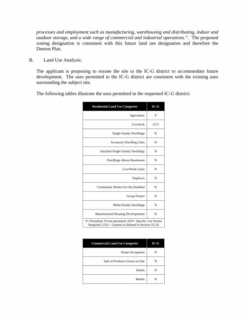
B. Land Use Analysis:
The applicant is proposing to rezone the site to the IC-G district to accommodate future development. The uses permitted in the IC-G district are consistent with the existing uses surrounding the subject site. The following tables illustrate the uses permitted in the requested IC-G district:
Residential Land Use Categories IC-G
Agriculture P
Livestock L(7)
Single Family Dwellings N
Accessory Dwelling Units N
Attached Single Family Dwellings N
Dwellings Above Businesses N
Live/Work Units N
Duplexes N
Community Homes For the Disabled N
Group Homes N
Multi-Family Dwellings N
Manufactured Housing Developments N
P= Permitted, N=not permitted, SUP= Specific Use Permit Required, L(X) = Limited as defined in Section 35.5.8
Commercial Land Use Categories IC-G
Home Occupation N
Sale of Products Grown on Site N
Hotels N
Motels N

Bed and Breakfast N
Retail Sales and Service L(18)
Movie Theaters N
Restaurant or Private Club L(22)
Drive-through Facility L(14)
Professional Services and Offices P
Quick Vehicle Servicing P
Vehicle Repair P
Auto and RV Sales P
Laundry Facilities P
Equestrian Facilities N
Outdoor Recreation N
Indoor Recreation N
Major Event Entertainment N
Commercial Parking Lots P
Administrative or Research Facilities P
Broadcasting of Production Studio P
Sexually Oriented Business SUP / L(32)
Temporary Uses L(38)
P= Permitted, N=not permitted, SUP= Specific Use Permit Required, L(X) = Limited as defined in Section 35.5.8
Industrial Land Use Categories IC-G
Printing / Publishing L(25)
Bakeries P
Manufacture of Non-odoriferous Foods P
Feed Lots N
Food Processing P
Light Manufacturing P
Heavy Manufacturing SUP

Wholesale Sales P
Wholesale Nurseries P
Distribution Center P
Wholesale Storage and Distribution P
Self-service Storage P
Construction Materials Sales P
Junk Yards and Auto Wrecking SUP
Wrecker Services and Impound Lots L(29)
Kennels N
Veterinary Clinics N
Sanitary Landfills, Commercial Incinerators, Transfer Stations SUP
Gas Wells L(27)
P= Permitted, N=not permitted, SUP= Specific Use Permit Required, L(X) = Limited as defined in Section 35.5.8
Institutional Land Use Categories IC-G
Basic Utilities P
Community Service P
Parks and Open Space P
Churches P
Semi-public, Halls, Clubs, and Lodges P
Business / Trade School P
Adult or Child Day Care N
Kindergarten, Elementary School N
Middle School N
High School N
Colleges N
Hospital N
Elderly Housing N
Medical Centers N

Cemeteries N
Mortuaries N
WECS (Free-standing Monopole Support Structure) SUP
WECS (Building-mounted) SUP
P= Permitted, N=not permitted, SUP= Specific Use Permit Required, L(X) = Limited as defined in Section 35.5.8
General Regulations IC-G
Minimum lot area (square feet) 5,000
Minimum lot width 50 feet
Minimum lot depth 50 feet
Minimum front yard setback 10 feet
Minimum side yard 6 feet
Minimum side yard adjacent to a street 10 feet
Minimum yard when abutting a residential use or district
30 feet, plus 1
foot for each foot
of building height
above 30 feet
Maximum FAR 0.40
Maximum lot coverage 90%
Minimum landscaped area 10%
Maximum building height 140 feet
Maximum WECS height 150 feet
Limitations
L(7) = Limited to two (2) animals on parcels one (1) to three (3) acres in size. Additional animals may be added at a rate of one per each acre over three. L(14) = Uses are limited to no more than 10,000 square feet of gross floor area
L(18) = Uses are permitted only in association with Gas Stations and are limited to no more than 5,000 square feet of gross floor area except adjacent to I-35 then uses are limited to 10,000 square feet of gross floor area.
L(22) = Uses are permitted only in association with Gas Stations and are limited to no more than 25 seats except adjacent to I-35 then the number of seats is limited to 50

L(25) = If proposed use is within 200 feet of a residential zone, approval is subject to a Specific Use Permit
L(27) = Must comply with the provisions of Subchapter 89, Gas Well Drilling and Production L(29) = Wrecker Services and Impound Lots must comply with the following provisions:
1. The subject lot shall comply with the provisions of the Texas Administrative Code, regarding Vehicle Storage Facilities.
2. Lot Screening: All stored vehicles shall be opaquely screened from all rights-of-way and residential uses and zoning districts.
3. Parking and vehicle storage areas associated with wrecker services and impound lots activities are not allowed within undeveloped floodplain, water-related habitat, and riparian buffer environmentally sensitive areas (ESA).
4. Best management practices addressing storm water quality must be implemented and maintained on site. Management practices must attain the pollutant removal capabilities recommended for parking areas in the Integrated Storm Water Management (iSWM) manual, as published by the North Central Texas Council of Governments, or similar practices consistent with low impact development (LID) approaches.
L (32) = Not allowed to locate adjacent to an arterial and within 1,000 feet as measured from the nearest property line of a sexually oriented business to the nearest property line of any other sexually oriented business, adult or child daycare, any elderly housing facility, hospital, any residential use, public open space.
L(38) = Must meet the requirements of Section 35.12.9.
B. Current Zoning District Allocation
Subject Property Future land Use/Zoning allocation
25.03 ± acres Current Allocation in the City Developed Allocation Change Based Upon Request
Industrial Center General 3,515.57 acres 16.2 acres + 22.03
Source: City of Denton Fire This submittal has been reviewed for compliance with the 2006 International Fire Code and City Ordinance 2009-098, Section 29-2 Amendments to the Fire Code. The applicant is responsible for compliance with all applicable portions of the Fire Code and City Ordinances even in the absence of review comments. Water and Wastewater Demand and Capacity: A. Estimated Demand and Service Provider:

Subject Property Estimated Impact Analysis
25.03 ± acres Proposed Demand Adequate to Serve (Yes or No)
Permitted Density n/a n/a Potable Water Consumption (GPM)
74.3 (peak) Yes
Wastewater Generation (GPM) 63.2 (peak) Yes
Source: City of Denton Water/Wastewater Department B. Available Capacity: Water is available from the existing 12-inch water main along Dakota Lane. Sewer is available from the existing 8-inch gravity main that goes through western portion of Applicant’s property; the existing 12-inch gravity main along Applicant’s west property line, and the existing 15-inch gravity main along Applicant’s east property line.
C. CIP Planned Improvements: There are no planned public improvements for the water and sanitary sewer facilities serving the subject site. Roadways/Transportation Network: A. Estimated Demand:
Subject Property Estimated Impact Analysis
25.03 ± acres Proposed Demand Adequate to Serve (Yes or No)
Permitted Density 220,350 SF YAverage Annual Daily Trips (AADT) 785 Y
PM Peak Hour Trips 100 YSource: City of Denton Engineering Department B. Available Capacity: The adjacent roadway network can accommodate the traffic generated by this development. C. Roadway Conditions: Corbin Road is classified as an unimproved perimeter street and is required to be improved upon development. D. CIP Planned Improvements:

Per the City of Denton (COD) Mobility plan, Shelby Lane is proposed to extend to the east and connect to Metro Street. Environmental Conditions: The subject property encroaches into undeveloped floodplain and stream buffer environmentally sensitive areas (ESAs). Any development requiring platting or replatting of the property would be subject to the ESAs regulations. Uses on property within undeveloped floodplain and stream buffers are subject to Sections 35.17.7 and 35.17.8 of the Denton Development Code (DDC). Electric: No Comment Park Facilities: No Comment Comments from other Departments: None

Exhibit 1 Site Location/Aerial Map

Exhibit 2 Zoning Map

Exhibit 3 Proposed Zoning Map

Exhibit 4 Future Land Use Map

Exhibit 5 Applicant’s Letter

Exhibit 6 Notification Map and Property Owner Responses
Public Notification Date: 9/14/12 200’ Legal Notices* sent via Certified Mail: 8500’ Courtesy Notices sent via Regular Mail: 19Number of responses to 200’ Legal Notice
In Opposition: 0 In Favor: 0 Neutral: 0

Exhibit 7 Site Photos
Eastern subject site Western subject site
South of Subject site Property between two sites
North of eastern site Property between two sites