Planning/Zoning Commission Meeting Tuesday, October 1 ...A5F773F8-CC22-42AE-AC… ·...
45
CITY OF ROCKVILLE City Hall 229 Broadway Street East PO Box 93 Rockville, MN 56369 Planning/Zoning Commission Meeting Tuesday, October 1, 2019 6:00 p.m. at City Hall AGENDA 1. Roll Call 2. Additions/Approval of Agenda 1 3. Approval of September 3, 2019 Planning Commission Meeting Minutes 2 4. Public Hearing – Preliminary and Final Plat Hilltop Woods 5 5. September 2019 Building Permits 45 6. Other Business a) Next Planning Commission meeting Tuesday, November 5, 2019, 6:00 p.m. 7. Adjournment *This agenda has been prepared to provide information regarding an upcoming meeting of the Rockville City Planning Commission. This document does not claim to be complete and is subject to change. 1
Transcript of Planning/Zoning Commission Meeting Tuesday, October 1 ...A5F773F8-CC22-42AE-AC… ·...
CITY OF ROCKVILLE
City Hall 229 Broadway Street East PO Box 93 Rockville, MN 56369
Planning/Zoning Commission Meeting Tuesday, October 1, 2019
6:00 p.m. at City Hall
AGENDA
1. Roll Call
2. Additions/Approval of Agenda 1
3. Approval of September 3, 2019 Planning Commission Meeting Minutes 2
4. Public Hearing – Preliminary and Final Plat Hilltop Woods 5
5. September 2019 Building Permits 45
6. Other Business
a) Next Planning Commission meeting Tuesday, November 5, 2019, 6:00 p.m.
7. Adjournment
*This agenda has been prepared to provide information regarding an upcoming meeting of the Rockville City Planning Commission. This documentdoes not claim to be complete and is subject to change.
1

MINUTES OF THE CITY OF ROCKVILLE PLANNING AND ZONING COMMISSIONTuesday, September 3, 2019, 6:00 p.m. – Rockville City Hall
Item 1) Roll Call
The meeting was called to order by Chair Bill Becker at 6:00 p.m. Roll call was taken and the followingmembers were present: Bill Becker, Brian Herberg, Dave Meyer, Chad Schmitt, and Corey Schreifels.Staff present: City Administrator, Martin Bode.Others present: Various members of the public.
Item 2) Approval of Agenda/Amendments
Motion by Herberg, second by Meyer, to approve the agenda as presented. Motion carried unanimously.
Item 3) Approval of August 6, 2019 Meeting Minutes
Motion by Meyer, second by Herberg, to approve the August 6, 2019 meeting minutes as presented. Motion carried unanimously.
Item 4) Public Hearing - Accessory Structure Variance Request Tom and Amanda Eich
Chairman Becker introduced and reviewed with the Planning Commission and the public the following Varianceapplication from Tom and Amanda Eich.
Staff ReportRe: Variance Request byApplicant/Owner: Thomas and Amanda EichPIN: 76.42170.0035Property Address: 6050 Scenic View Court, Rockville MN
Variance(s) Requested:1. Locate a new accessory structure in the side/front yard of property - (Section 9, Subd 2.D.1 – rear and
side yard only)2. Construct a 5,280-sf accessory structure with 18-foot sidewalls -
Section 17, Subdivision 3 Permitted Accessory Uses. 1. Accelerated Accessory Structure, Area -70,000-sf to 85,000-sf = 2,400-sf w/14 Sidewalls
Relevant Information:1. Property is zoned RR, Schneider Farm Plat.2. Recently combined two parcels into one.3. Property contains approximately 10.3 +/- acres.4. 18 Public Hearing notices were mailed out.
Action:1. Findings of Fact
Recommendation:Consider approval.--
Chairman Becker opened the public hearing at 6:03 p.m. for public comment.
Administrator Bode noted that the side and rear yard setbacks are no longer relevant with the recent zoningordinance changes approved by Council. Also noted the property will have two driveways – one for the principalstructure and one for the accessory structure.
Paul Massmann, 7468 County Road 141, inquired about the road completion before building begins.
Lloyd Lommel, 7682 County Road 141, concerned about the wetlands in this development and the 18’sidewalls.
Amanda Eich, 278 Jeanne Avenue, Eden Valley, stated that the accessory size is because her husband’s atruck driver and will park his tractor semi and trailer inside and to allow room for ceiling fans.
Kevin Voigt, 7819 County Road 141, has concerns regarding the size of the building.
2

Letter from Robert Schmelzer, 7725 County Road 141, expressed opposition to approving a variance beforefuture landowners have input.
There being no further comments from the public, motion was made by Herberg, second by Schreifels, to close the Public Hearing at 6:08 p.m. Motion carried.
Planning Commission reviewed the application and held further discussion.
Motion by Meyer, second by Herberg, to approve the Accessory Structure Variance Request for Tom and Amanda Eich as presented. Motion passed unanimously.
The Planning Commission determined that the applicant for the variance has established that there are practicaldifficulties in complying with the zoning ordinance and that the Planning Commission has considered thefollowing criteria as defined in Minnesota Statutes Section 462 and Minnesota Statues Section 394.27 andmakes the following Findings of Fact:
1. The variance is in harmony with the purposes and intent of the ordinance.2. The variance is consistent with the comprehensive plan.3. The proposal does put property to use in a reasonable manner.4. There are unique circumstances to the property not created by the landowner.5. The variance will continue to maintain the essential character of the locality.
Following the discussion, motion by Herberg, second by Becker, to approve the Findings of Fact for the Tom and Amanda Eich Variance request. Motion carried unanimously.
Item 5) Hieserich dba Pickups N Powersports Interim/Conditional Use Permit
Chairman Becker informed the Planning Commission that the City Council has returned the Heiserich CUPapplication to operate Pickups N Powersports back to the Planning Commission to allow the Commission toreconsider the application if certain conditions were added such as:
The Conditional Use Permit IF approved, to operate a power sports retail sales/maintenance shop business in an A-40 Agricultural District in Rockville Zoning with the following conditions:
1. Hours of operation shall be between the hours of 7:00 a.m. and 7:00 p.m. Monday through Friday. Forbusiness as well as personnel use.
2. Must obtain and maintain a Hazardous Waste Licensee from the Minnesota Pollution Control Agency(MPCA).
3. Must provide secondary containment for all hazardous waste.4. Installation of 5-foot-tall trees spaced every 12 feet on the west property line.5. All outside parked vehicles must have current licenses.6. All outside parking must be on improved surface (gravel, tar, or concrete).7. No outside storage of “refuse” as defined by Section 8 of the Rockville Zoning Code i.e. junk cars, parts,
steel, iron, rubbish.8. Solid waste services must be provided by a City of Rockville permitted hauler on a weekly basis.9. Property owner is responsible for all cost(s) associated with enforcement of the terms of the conditional
use permit.10. Must place $3,000.00 into a City escrow account.11. This Conditional Use Permit is good for one (1) year from the date of Council approval.
Planning Commission held extensive discussion before calling the vote.
Motion by Meyer, second by Schreifels, to deny the Hieserich dba Pickups N’ Powersports Interim/Conditional Use Permit. Roll call vote: Ayes; Becker, Meyer, Schmitt, Schreifels. Nayes; Herberg. Motion carried on a 4-1 vote.
Item 6) Voigt Administrative Subdivision Registered Land Survey Preliminary/Final
Chairman Becker introduced and reviewed with the Planning Commission the following AdministrativeSubdivision application from James and Jacqueline Voigt.
3

Staff ReportRe: Administrative Subdivision Registered Land Survey No.14Owner: James and Jacqueline VoigtProperty Address: adjacent to 25293 Pleasant RoadKnown as: Registered Land Survey 14Parcel I.D. 76.41601.0625 - Section 1 & 2, Township 123, Range 029
Request:Administrative Subdivision by Registered Land Survey No.14
Relevant Information:1. Property is zoned Ag-402. Property is titled by Registered Land Survey3. Total subdivided area is 14,715 sf or 45’ x 327’ +/-4. No new lots/parcel are created5. Purpose: neighbor is buying the additional 45-foot wide subdivision and attaching to their existing
parcel. Parcel No. 76.42160.09306. Administrative Plats do not require a public hearing or Planning Commission/Council approval.
However, because of the Registered Land Survey and requirement to be recorded by mylar which willneed to be signed by Planning Commission Chair and City Mayor, Planning Commission and Councilapproval is being requested.
Recommendation:Consider approval of:
1. Preliminary and Final Registered Land Survey No.14
Motion by Meyer, second by Schreifels, to approve the Voigt Administrative Subdivision Registered Land Survey No.14 Preliminary and Final as presented. Motion carried unanimously.
Item 7) August 2019 Building Permits
The August 2019 building permits report was reviewed by the Planning Commission members.
Item 8) Other Business
a. Next meeting scheduled for Tuesday, October 1, 2019 at 6:00 p.m.
Item 9) Adjournment
Motion by Herberg, second by Schreifels, to adjourn the meeting. Motion carried unanimously. Meeting adjourned at 6:32 p.m.
Respectfully submitted,
Martin M. Bode Zoning Administrator
4

STAFF REPORT
October 1 and October 9, 2019
Rockville Planning Commission / City Council
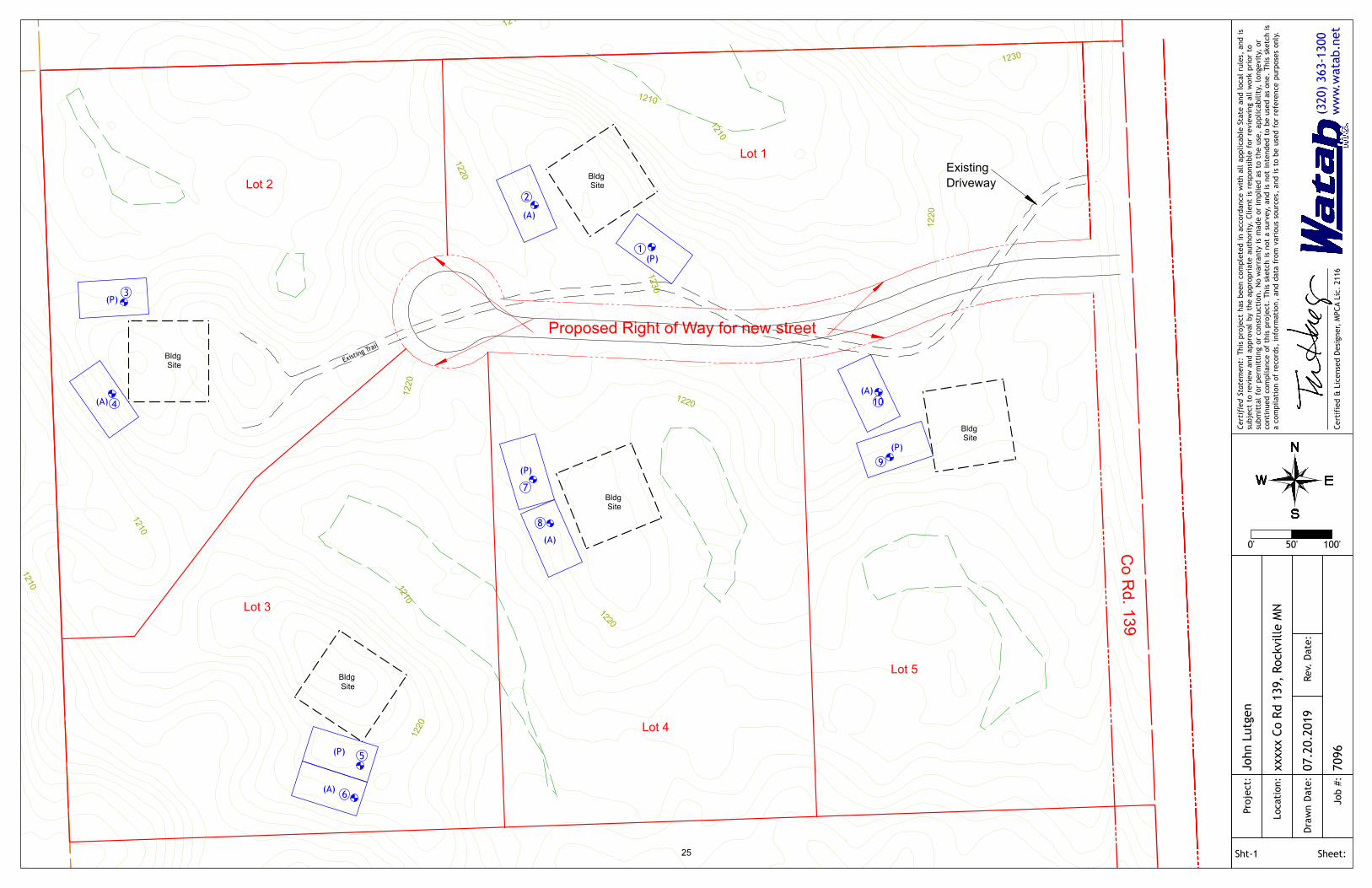
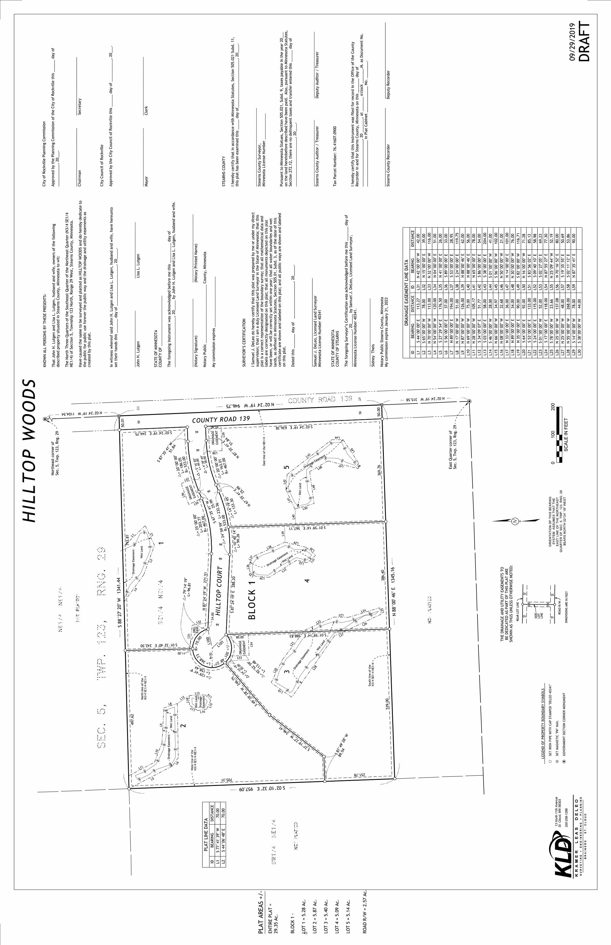
RE: Preliminary and Final Plat know as Hilltop Woods
Owner: John and Lisa Lutgen
The legal description of the property is: The Southeast Quarter of the Northeast Quarter (SE1/4
NE1/4), LESS AND EXCEPT: The South one-fourth of the SE1/4 of NE1/4, all in Section (5) in
Township One Hundred Twenty-three (123), Range Twenty-nine (29), Stearns County, Minnesota.
Parcel No. 76.41607.0900
Request:
To Subdivide 30 +/- acres into Five (5), 5 +/- acre lots
Relevant Information:
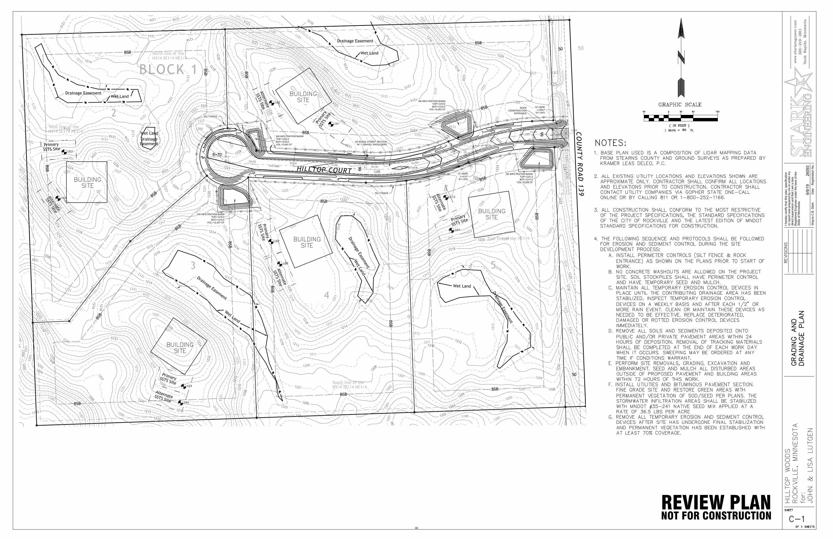
1. Property was rezoned from Ag-40 to R-R with a PUD Overlay. (May 8, 2019 Council Meeting)2. Lot size is 30 +/- acres.3. Proposed Plat is five (5) lots at 5 +/- acres per lots4. Purpose is residential development.5. Meets City of Rockville Zoning requirements of Section 16A: Rural Residential District “R-R District”6. Proposed access road is a private – Concerns: Rd Safety Standards-Rd Maintenance-Storm Water
7. Planning Commission Public Hearing on October 1, 20198. 10 notices of public hearing were sent out.
Recommendation:
Consider Approval
Submitted by: Martin M. Bode Zoning Administrator
5

6
7
8

9

10

11

12
13
MPCA Certified and LicensedAdvanced SSTS Professionals
14234 Fruit Farm RoadSt. Joseph MN 56374
320-363-1300www.watab.net
Report Date:
Project ID:
5 123 Range: 29
Septic Site Identification
7/20/2019
7096
Newly Platted Lots
Project:
John Lutgen
Location:
County Road 139, St. Cloud MN 5630130 acres, to be split into 5 lots
76.41607.0900Stearns CountyCity of Rockville
Notes:
Have a nice day.
Section: Township:
14

Job #© 2019 Watab Inc
Observation #:
Elevation: Depth to Restrictive: 12 Restrictive Elevation:
Method: Vegetation: Woods/Brush Landscape:
ELEV. DEPTH
(ft.) (in.) H V / C H V / C TYPE
Comments:
Certification:
Watab Inc. MPCA Lic. 2116
This site is suitable for a Type-I above-ground (mound) sewage treatment system.
Additional testing and design required prior to permitting and installation.
5/2 & 5/6 S1
2.5Y
1227.42 19
1226.33 32
4/4 2.5Y 5/2 & 5/6 S1 Sandy Loam <35 Platy Strong Very Firm N
01229.00
41228.67
121228.00
<35 Blocky
Exposed Pit Backslope
Moderate Friable N
10YR 2/1 Loam <35 Blocky Moderate Friable N
10YR 4/3
2.5Y 4/4 2.5Y
Soil Observation Log7096
1
1229.00 1228.00
SHAPE - GRADE - CONSISTENCE
I certify that these data are the findings of a certified, licensed professional and representative of the proposed work area. 7/1/2019
Date
SUBSTRATE REDOX / INDICATOR SOILTEXTURE
% ROCK
SOIL STRUCTURE H2OY/N
Sandy Loam <35 Blocky Moderate Friable N
Silt Loam
15
Job #© 2019 Watab Inc
Observation #:
Elevation: Depth to Restrictive: 14 Restrictive Elevation:
Method: Vegetation: Woods/Brush Landscape:
ELEV. DEPTH
(ft.) (in.) H V / C H V / C TYPE
Comments:
Certification:
Watab Inc. MPCA Lic. 2116
Soil Observation Log7096
2
1227.00 1225.83
Exposed Pit Backslope
Blocky Moderate Friable N
SHAPE - GRADE - CONSISTENCE
1227.00 0
10YR 2/1 Loam
SUBSTRATE REDOX / INDICATOR SOILTEXTURE
% ROCK
SOIL STRUCTURE H2OY/N
N
1226.17 10
10YR 4/3 Sandy Loam
Sandy Loam, moist <35 Blocky Moderate Friable
1226.67 4
10YR 4/3
<35
10YR 4/3 10YR 5/2 & 5/6
<35 Blocky Strong Firm N
<35 Platy Strong Very Firm N
N
1224.92 25
2.5Y 4/4 2.5Y 5/2 & 5/6 S1 Sandy Clay Loam
S1 Sandy Loam <35 Blocky Strong Firm
1225.83 14
1224.00 36
I certify that these data are the findings of a certified, licensed professional and representative of the proposed work area. 7/1/2019
Date
This site is suitable for a Type-I above-ground (mound) sewage treatment system.
Additional testing and design required prior to permitting and installation.
16

Job #© 2019 Watab Inc
Observation #:
Elevation: Depth to Restrictive: 16 Restrictive Elevation:
Method: Vegetation: Woods/Clearing Landscape:
ELEV. DEPTH
(ft.) (in.) H V / C H V / C TYPE
Comments:
Certification:
Watab Inc. MPCA Lic. 2116
Soil Observation Log7096
3
1219.50 1218.17
Exposed Pit Backslope
Blocky Moderate Friable N
SHAPE - GRADE - CONSISTENCE
1219.50 0
10YR 2/1 Loam
SUBSTRATE REDOX / INDICATOR SOILTEXTURE
% ROCK
SOIL STRUCTURE H2OY/N
wet
1218.17 16
10YR 4/3 10YR faint 5/2 Sandy Loam, moist
Sandy Loam <35 Blocky Moderate Friable
1219.17 4
10YR 3/2
<35
10YR 4/3 10YR 5/2 & 5/6
<35 Blocky Moderate Friable N
N
1216.17 40
S1 Sandy Loam <35 Blocky Strong Firm
1217.58 23
I certify that these data are the findings of a certified, licensed professional and representative of the proposed work area. 7/1/2019
Date
This site is suitable for a Type-I above-ground (mound) sewage treatment system.
Additional testing and design required prior to permitting and installation.
17

Job #© 2019 Watab Inc
Observation #:
Elevation: Depth to Restrictive: 13 Restrictive Elevation:
Method: Vegetation: Woods/Clearing Landscape:
ELEV. DEPTH
(ft.) (in.) H V / C H V / C TYPE
Comments:
Certification:
Watab Inc. MPCA Lic. 2116
Soil Observation Log7096
4
1221.50 1220.42
Exposed Pit Backslope
Blocky Moderate Friable N
SHAPE - GRADE - CONSISTENCE
1221.50 0
10YR 2/1 Loam
SUBSTRATE REDOX / INDICATOR SOILTEXTURE
% ROCK
SOIL STRUCTURE H2OY/N
N
1220.42 13
10YR 4/3 10YR 5/2 & 5/6 S1 Sandy Clay Loam
Sandy Loam <35 Blocky Moderate Friable
1221.08 5
10YR 4/3
<35
7.5YR 4/4 7.5YR 5/2 & 5/6
<35 Blocky Strong Firm N
N
1218.58 35
S1 Clay Loam <35 Blocky Strong Very Firm
1219.83 20
I certify that these data are the findings of a certified, licensed professional and representative of the proposed work area. 7/1/2019
Date
This site is suitable for a Type-I above-ground (mound) sewage treatment system.
Additional testing and design required prior to permitting and installation.
18

Job #© 2019 Watab Inc
Observation #:
Elevation: Depth to Restrictive: 14 Restrictive Elevation:
Method: Vegetation: Woods Landscape:
ELEV. DEPTH
(ft.) (in.) H V / C H V / C TYPE
Comments:
Certification:
Watab Inc. MPCA Lic. 2116
Soil Observation Log7096
5
1219.50 1218.33
Exposed Pit Backslope
Blocky Moderate Friable N
SHAPE - GRADE - CONSISTENCE
1219.50 0
10YR 2/1 Loam
SUBSTRATE REDOX / INDICATOR SOILTEXTURE
% ROCK
SOIL STRUCTURE H2OY/N
wet
1218.33 14
10YR 4/3 10YR 5/2 & 5/6 S1 Sandy Clay Loam
Sandy Loam <35 Blocky Moderate Friable
1219.17 4
10YR 4/3
<35
7.5YR 4/4 7.5YR 5/2 & 5/6
<35 Blocky Strong Firm N
N
1216.58 35
S1 Sandy Clay Loam <35 Massive Strong Very Firm
1217.58 23
I certify that these data are the findings of a certified, licensed professional and representative of the proposed work area. 7/1/2019
Date
This site is suitable for a Type-I above-ground (mound) sewage treatment system.
Additional testing and design required prior to permitting and installation.
19

Job #© 2019 Watab Inc
Observation #:
Elevation: Depth to Restrictive: 12 Restrictive Elevation:
Method: Vegetation: Woods Landscape:
ELEV. DEPTH
(ft.) (in.) H V / C H V / C TYPE
Comments:
Certification:
Watab Inc. MPCA Lic. 2116
Soil Observation Log7096
6
1218.00 1217.00
Exposed Pit Backslope
Blocky Moderate Friable N
SHAPE - GRADE - CONSISTENCE
1218.00 0
10YR 2/1 Loam
SUBSTRATE REDOX / INDICATOR SOILTEXTURE
% ROCK
SOIL STRUCTURE H2OY/N
N
1217.00 12
10YR 4/3 10YR 5/2 & 5/6 S1 Clay Loam
Sandy Loam <35 Blocky Moderate Friable
1217.67 4
10YR 4/3
<35
<35 Blocky Strong Very Firm N
1215.00 36
I certify that these data are the findings of a certified, licensed professional and representative of the proposed work area. 7/1/2019
Date
This site is suitable for a Type-I above-ground (mound) sewage treatment system.
Additional testing and design required prior to permitting and installation.
20
Job #© 2019 Watab Inc
Observation #:
Elevation: Depth to Restrictive: 12 Restrictive Elevation:
Method: Vegetation: Woods Landscape:
ELEV. DEPTH
(ft.) (in.) H V / C H V / C TYPE
Comments:
Certification:
Watab Inc. MPCA Lic. 2116
Soil Observation Log7096
7
1220.30 1219.30
Exposed Pit Backslope
Blocky Moderate Friable N
SHAPE - GRADE - CONSISTENCE
1220.30 0
10YR 3/2 Loam
SUBSTRATE REDOX / INDICATOR SOILTEXTURE
% ROCK
SOIL STRUCTURE H2OY/N
N
1219.30 12
10YR 4/3 10YR 5/2 & 5/6 S1 Sandy Loam
Sandy Loam <35 Blocky Moderate Friable
1219.80 6
10YR 4/3
<35
10YR 4/3 10YR 5/2 & 5/6
<35 Blocky Moderate Friable N
<35 Blocky Strong Firm N
@ 18''
1218.47 22
10YR 4/3 10YR 5/2 & 5/6 S1 Sandy Clay Loam
S1 Sandy Loam <35 Blocky Moderate Friable
1218.80 18
1217.30 36
I certify that these data are the findings of a certified, licensed professional and representative of the proposed work area. 7/1/2019
Date
This site is suitable for a Type-I above-ground (mound) sewage treatment system.
Additional testing and design required prior to permitting and installation.
21

Job #© 2019 Watab Inc
Observation #:
Elevation: Depth to Restrictive: 18 Restrictive Elevation:
Method: Vegetation: Woods Landscape:
ELEV. DEPTH
(ft.) (in.) H V / C H V / C TYPE
Comments:
Certification:
Watab Inc. MPCA Lic. 2116
Soil Observation Log7096
8
1220.00 1218.50
Exposed Pit Backslope
Blocky Moderate Friable N
SHAPE - GRADE - CONSISTENCE
1220.00 0
10YR 2/2 Loam
SUBSTRATE REDOX / INDICATOR SOILTEXTURE
% ROCK
SOIL STRUCTURE H2OY/N
N
1218.83 14
10YR 4/3 10YR faint 5/2 & 5/6 S1 Sandy Loam
Sandy Loam <35 Blocky Moderate Friable
1219.58 5
10YR 4/3
<35
10YR 4/6 10YR 5/2 & 5/6
<35 Blocky Moderate Firm N
N
1217.00 36
S1 Clay Loam <35 Blocky Strong Firm
1218.50 18
I certify that these data are the findings of a certified, licensed professional and representative of the proposed work area. 7/1/2019
Date
This site is suitable for a Type-I above-ground (mound) sewage treatment system.
Additional testing and design required prior to permitting and installation.
22

Job #© 2019 Watab Inc
Observation #:
Elevation: Depth to Restrictive: 14 Restrictive Elevation:
Method: Vegetation: Woods Landscape:
ELEV. DEPTH
(ft.) (in.) H V / C H V / C TYPE
Comments:
Certification:
Watab Inc. MPCA Lic. 2116
Soil Observation Log7096
9
1224.50 1223.33
Exposed Pit Backslope
Blocky Moderate Friable N
SHAPE - GRADE - CONSISTENCE
1224.50 0
10YR 2/2 Loam
SUBSTRATE REDOX / INDICATOR SOILTEXTURE
% ROCK
SOIL STRUCTURE H2OY/N
N
1223.33 14
10YR 5/3 10YR 5/2 & 5/6 S1 Sandy Loam
Sandy Loam <35 Blocky Moderate Friable
1224.08 5
10YR 4/3
<35
10YR 4/4 10YR 5/2 & 5/6
<35 Blocky Moderate Firm N
N
1221.83 32
S1 Sandy Clay Loam <35 Blocky Strong Very Firm
1222.83 20
I certify that these data are the findings of a certified, licensed professional and representative of the proposed work area. 7/1/2019
Date
This site is suitable for a Type-I above-ground (mound) sewage treatment system.
Additional testing and design required prior to permitting and installation.
23
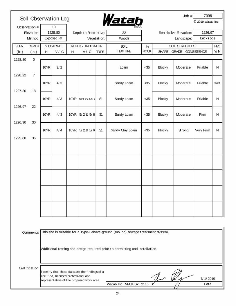
Job #© 2019 Watab Inc
Observation #:
Elevation: Depth to Restrictive: 22 Restrictive Elevation:
Method: Vegetation: Woods Landscape:
ELEV. DEPTH
(ft.) (in.) H V / C H V / C TYPE
Comments:
Certification:
Watab Inc. MPCA Lic. 2116
Soil Observation Log7096
10
1228.80 1226.97
Exposed Pit Backslope
Blocky Moderate Friable N
SHAPE - GRADE - CONSISTENCE
1228.80 0
10YR 2/2 Loam
SUBSTRATE REDOX / INDICATOR SOILTEXTURE
% ROCK
SOIL STRUCTURE H2OY/N
wet
1227.30 18
10YR 4/3 10YR faint 5/2 & 5/6 S1 Sandy Loam
Sandy Loam <35 Blocky Moderate Friable
1228.22 7
10YR 4/3
<35
10YR 4/3 10YR 5/2 & 5/6
<35 Blocky Moderate Friable N
<35 Blocky Strong Very Firm N
N
1226.30 30
10YR 4/4 10YR 5/2 & 5/6 S1 Sandy Clay Loam
S1 Sandy Loam <35 Blocky Moderate Firm
1226.97 22
1225.80 36
I certify that these data are the findings of a certified, licensed professional and representative of the proposed work area. 7/1/2019
Date
This site is suitable for a Type-I above-ground (mound) sewage treatment system.
Additional testing and design required prior to permitting and installation.
24
Proj
ect:
Loca
tion
:
Dra
wn
Dat
e:
Job
#:
John
Lut
gen
xxxx
x Co
Rd
139,
Roc
kvill
e M
N
07.2
0.20
19
7096
Rev.
Dat
e:
Cert
ifie
d S
tate
men
t: T
his
proj
ect
has
been
com
plet
ed in
acc
orda
nce
wit
h al
l ap
plic
able
Sta
te a
nd lo
cal
rule
s, a
nd is
su
bjec
t to
rev
iew
and
app
rova
l by
the
app
ropr
iate
aut
hori
ty.
Clie
nt is
res
pons
ible
for
rev
iew
ing
all
wor
k pr
ior
to
subm
itta
l fo
r pe
rmit
ting
or
cons
truc
tion
. N
o w
arra
nty
is m
ade
or im
plie
d a
s to
the
use
, ap
plic
abili
ty,
long
evit
y, o
r co
ntin
ued
com
plia
nce
of
this
pro
ject
. Th
is s
ketc
h is
not
a s
urve
y, a
nd is
not
inte
nded
to
be u
sed
as o
ne.
This
ske
tch
is
a co
mpi
lati
on o
f re
cord
s, in
form
atio
n,
and
data
fro
m v
ario
us s
ourc
es,
and
is t
o be
use
d fo
r re
fere
nce
purp
oses
onl
y.
Cert
ifie
d &
Lic
ense
d D
esig
ner,
MPC
A Li
c. 2
116
(320
) 36
3-13
00w
ww
.wat
ab.n
et
Sheet:Sht-1
3
2
1
4
5
6
7
8
9
10
(A)
(P)
(P)
(A)
(A)
(P)
(A)
(P)
(A)
(P)
Bldg Site
Bldg Site
Bldg Site
Bldg Site
Bldg Site
Lot 1
Lot 2
Lot 3
Lot 4
Lot 5
Co R
d. 139
Existing Driveway
Proposed Right of Way for new street
1210
1230
1210
1210
1220
1220
1230
1220
1220
1210
1210 1210
12201200
1220
Existing Tr
ail
0' 100'50'
25

Parcel ID 76.41607.0900
Sec/Twp/Rng 05/123/029
Property Address
Alternate ID n/a
Class 2B-Rural Vacant Land/Non-Productive - Non Homestead
Acreage 30
Owner Address JOHN H & LISA L LUTGEN
3130 COUNTY ROAD 137
WAITE PARK MN 56387
District 7605 ROCKVILLE CITY 750
Brief Tax Description 30.00A N3/4SE4NE4
(Note: Not to be used on legal documents)
150 ft
26

Soil Map—Stearns County, Minnesota(Lutgen)
Natural ResourcesConservation Service
Web Soil SurveyNational Cooperative Soil Survey
6/4/2019Page 1 of 3
5038
790
5038
840
5038
890
5038
940
5038
990
5039
040
5039
090
5039
140
5038
790
5038
840
5038
890
5038
940
5038
990
5039
040
5039
090
394550 394600 394650 394700 394750 394800 394850 394900 394950 395000 395050
394550 394600 394650 394700 394750 394800 394850 394900 394950 395000 395050
45° 29' 52'' N94
° 2
0' 5
9'' W
45° 29' 52'' N
94° 2
0' 3
4'' W
45° 29' 40'' N
94° 2
0' 5
9'' W
45° 29' 40'' N
94° 2
0' 3
4'' W
N
Map projection: Web Mercator Corner coordinates: WGS84 Edge tics: UTM Zone 15N WGS840 100 200 400 600
Feet0 35 70 140 210
MetersMap Scale: 1:2,530 if printed on A landscape (11" x 8.5") sheet.
Soil Map may not be valid at this scale.
27
MAP LEGEND MAP INFORMATION
Area of Interest (AOI)Area of Interest (AOI)
SoilsSoil Map Unit Polygons
Soil Map Unit Lines
Soil Map Unit Points
Special Point FeaturesBlowout
Borrow Pit
Clay Spot
Closed Depression
Gravel Pit
Gravelly Spot
Landfill
Lava Flow
Marsh or swamp
Mine or Quarry
Miscellaneous Water
Perennial Water
Rock Outcrop
Saline Spot
Sandy Spot
Severely Eroded Spot
Sinkhole
Slide or Slip
Sodic Spot
Spoil Area
Stony Spot
Very Stony Spot
Wet Spot
Other
Special Line Features
Water FeaturesStreams and Canals
TransportationRails
Interstate Highways
US Routes
Major Roads
Local Roads
BackgroundAerial Photography
The soil surveys that comprise your AOI were mapped at 1:15,800.
Warning: Soil Map may not be valid at this scale.
Enlargement of maps beyond the scale of mapping can cause misunderstanding of the detail of mapping and accuracy of soil line placement. The maps do not show the small areas of contrasting soils that could have been shown at a more detailed scale.
Please rely on the bar scale on each map sheet for map measurements.
Source of Map: Natural Resources Conservation ServiceWeb Soil Survey URL: Coordinate System: Web Mercator (EPSG:3857)
Maps from the Web Soil Survey are based on the Web Mercator projection, which preserves direction and shape but distorts distance and area. A projection that preserves area, such as the Albers equal-area conic projection, should be used if more accurate calculations of distance or area are required.
This product is generated from the USDA-NRCS certified data as of the version date(s) listed below.
Soil Survey Area: Stearns County, MinnesotaSurvey Area Data: Version 16, Sep 12, 2018
Soil map units are labeled (as space allows) for map scales 1:50,000 or larger.
Date(s) aerial images were photographed: May 5, 2016—Oct 6, 2017
The orthophoto or other base map on which the soil lines were compiled and digitized probably differs from the background imagery displayed on these maps. As a result, some minor shifting of map unit boundaries may be evident.
Soil Map—Stearns County, Minnesota(Lutgen)
Natural ResourcesConservation Service
Web Soil SurveyNational Cooperative Soil Survey
6/4/2019Page 2 of 3
28

Map Unit Legend
Map Unit Symbol Map Unit Name Acres in AOI Percent of AOI
204B Cushing sandy loam, 2 to 8 percent slopes
15.0 45.7%
204C Cushing sandy loam, 8 to 15 percent slopes
12.2 37.2%
292B Alstad sandy loam, 1 to 4 percent slopes
1.4 4.4%
873 Prebish-Nokay complex 4.2 12.7%
Totals for Area of Interest 32.8 100.0%
Soil Map—Stearns County, Minnesota Lutgen
Natural ResourcesConservation Service
Web Soil SurveyNational Cooperative Soil Survey
6/4/2019Page 3 of 3
29

Stearns County, Minnesota
204B—Cushing sandy loam, 2 to 8 percent slopes
Map Unit SettingNational map unit symbol: gcgtElevation: 780 to 1,360 feetMean annual precipitation: 23 to 29 inchesMean annual air temperature: 37 to 43 degrees FFrost-free period: 120 to 175 daysFarmland classification: All areas are prime farmland
Map Unit CompositionCushing and similar soils: 90 percentMinor components: 10 percentEstimates are based on observations, descriptions, and transects of
the mapunit.
Description of Cushing
SettingLandform: MorainesLandform position (two-dimensional): BackslopeDown-slope shape: LinearAcross-slope shape: LinearParent material: Till
Typical profileA - 0 to 5 inches: sandy loamE - 5 to 15 inches: sandy loamB/E - 15 to 19 inches: sandy loamBt - 19 to 47 inches: sandy clay loamC - 47 to 60 inches: sandy loam
Properties and qualitiesSlope: 2 to 8 percentDepth to restrictive feature: More than 80 inchesNatural drainage class: Well drainedCapacity of the most limiting layer to transmit water (Ksat):
Moderately low to moderately high (0.14 to 0.57 in/hr)Depth to water table: More than 80 inchesFrequency of flooding: NoneFrequency of ponding: NoneCalcium carbonate, maximum in profile: 10 percentAvailable water storage in profile: High (about 9.0 inches)
Interpretive groupsLand capability classification (irrigated): None specifiedLand capability classification (nonirrigated): 2eHydrologic Soil Group: BForage suitability group: Sloping Upland, Acid (G090XN006MN)Hydric soil rating: No
Map Unit Description: Cushing sandy loam, 2 to 8 percent slopes---Stearns County, Minnesota Lutgen
Natural ResourcesConservation Service
Web Soil SurveyNational Cooperative Soil Survey
6/4/2019Page 1 of 2
30

Minor Components
DemontrevillePercent of map unit: 3 percentHydric soil rating: No
PrebishPercent of map unit: 3 percentLandform: Depressions on moraines, drainageways on morainesHydric soil rating: Yes
JewettPercent of map unit: 2 percentHydric soil rating: No
NokayPercent of map unit: 2 percentHydric soil rating: No
Data Source Information
Soil Survey Area: Stearns County, MinnesotaSurvey Area Data: Version 16, Sep 12, 2018
Map Unit Description: Cushing sandy loam, 2 to 8 percent slopes---Stearns County, Minnesota Lutgen
Natural ResourcesConservation Service
Web Soil SurveyNational Cooperative Soil Survey
6/4/2019Page 2 of 2
31

Stearns County, Minnesota
204C—Cushing sandy loam, 8 to 15 percent slopes
Map Unit SettingNational map unit symbol: gcgvElevation: 780 to 1,360 feetMean annual precipitation: 23 to 29 inchesMean annual air temperature: 37 to 43 degrees FFrost-free period: 120 to 175 daysFarmland classification: Farmland of statewide importance
Map Unit CompositionCushing and similar soils: 90 percentMinor components: 10 percentEstimates are based on observations, descriptions, and transects of
the mapunit.
Description of Cushing
SettingLandform: MorainesLandform position (two-dimensional): BackslopeDown-slope shape: LinearAcross-slope shape: LinearParent material: Till
Typical profileA - 0 to 5 inches: sandy loamE - 5 to 12 inches: sandy loamB/E - 12 to 19 inches: sandy loamBt - 19 to 31 inches: sandy clay loamC - 31 to 60 inches: sandy loam
Properties and qualitiesSlope: 8 to 15 percentDepth to restrictive feature: More than 80 inchesNatural drainage class: Well drainedCapacity of the most limiting layer to transmit water (Ksat):
Moderately low to moderately high (0.14 to 0.57 in/hr)Depth to water table: More than 80 inchesFrequency of flooding: NoneFrequency of ponding: NoneCalcium carbonate, maximum in profile: 10 percentAvailable water storage in profile: Moderate (about 8.9 inches)
Interpretive groupsLand capability classification (irrigated): None specifiedLand capability classification (nonirrigated): 3eHydrologic Soil Group: CForage suitability group: Sloping Upland, Acid (G090XN006MN)Hydric soil rating: No
Map Unit Description: Cushing sandy loam, 8 to 15 percent slopes---Stearns County, Minnesota
Lutgen
Natural ResourcesConservation Service
Web Soil SurveyNational Cooperative Soil Survey
6/4/2019Page 1 of 2
32

Minor Components
DemontrevillePercent of map unit: 3 percentHydric soil rating: No
PrebishPercent of map unit: 3 percentLandform: Depressions on moraines, drainageways on morainesHydric soil rating: Yes
JewettPercent of map unit: 2 percentHydric soil rating: No
NokayPercent of map unit: 2 percentHydric soil rating: No
Data Source Information
Soil Survey Area: Stearns County, MinnesotaSurvey Area Data: Version 16, Sep 12, 2018
Map Unit Description: Cushing sandy loam, 8 to 15 percent slopes---Stearns County, Minnesota
Lutgen
Natural ResourcesConservation Service
Web Soil SurveyNational Cooperative Soil Survey
6/4/2019Page 2 of 2
33
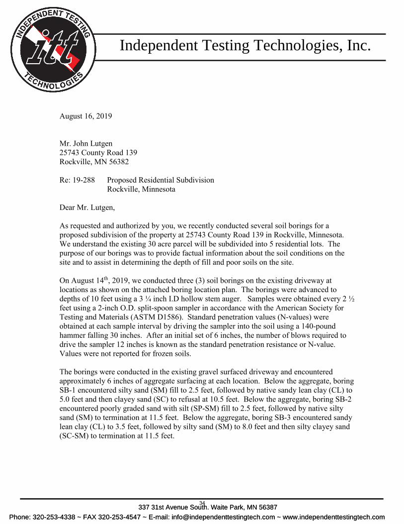
August 16, 2019
Mr. John Lutgen 25743 County Road 139 Rockville, MN 56382
Re: 19-288 Proposed Residential Subdivision Rockville, Minnesota
Dear Mr. Lutgen,
As requested and authorized by you, we recently conducted several soil borings for a proposed subdivision of the property at 25743 County Road 139 in Rockville, Minnesota. We understand the existing 30 acre parcel will be subdivided into 5 residential lots. The purpose of our borings was to provide factual information about the soil conditions on the site and to assist in determining the depth of fill and poor soils on the site.
On August 14th, 2019, we conducted three (3) soil borings on the existing driveway at locations as shown on the attached boring location plan. The borings were advanced to depths of 10 feet using a 3 ¼ inch I.D hollow stem auger. Samples were obtained every 2 ½ feet using a 2-inch O.D. split-spoon sampler in accordance with the American Society for Testing and Materials (ASTM D1586). Standard penetration values (N-values) were obtained at each sample interval by driving the sampler into the soil using a 140-pound hammer falling 30 inches. After an initial set of 6 inches, the number of blows required to drive the sampler 12 inches is known as the standard penetration resistance or N-value. Values were not reported for frozen soils.
The borings were conducted in the existing gravel surfaced driveway and encountered approximately 6 inches of aggregate surfacing at each location. Below the aggregate, boring SB-1 encountered silty sand (SM) fill to 2.5 feet, followed by native sandy lean clay (CL) to 5.0 feet and then clayey sand (SC) to refusal at 10.5 feet. Below the aggregate, boring SB-2 encountered poorly graded sand with silt (SP-SM) fill to 2.5 feet, followed by native silty sand (SM) to termination at 11.5 feet. Below the aggregate, boring SB-3 encountered sandy lean clay (CL) to 3.5 feet, followed by silty sand (SM) to 8.0 feet and then silty clayey sand (SC-SM) to termination at 11.5 feet.
Indepedent Testing Technologies, Inc.Independent Testing Technologies, Inc.
337 31st Avenue South. Waite Park, MN 56387
Phone: 320-253-4338~ FAX 320-253-4547~ E-mail: [email protected]~www.independenttestingtech.comPhone: 320-253-4338 ~ FAX 320-253-4547 ~ E-mail: [email protected] ~ www.independenttestingtech.com
337 31st Avenue South. Waite Park, MN 56387
Phone: 320-253-4338~ FAX 320-253-4547~ E-mail: [email protected]~www.independenttestingtech.comPhone: 320-253-4338 ~ FAX 320-253-4547 ~ E-mail: [email protected] ~ www.independenttestingtech.com
34

August 16, 2019 Project 19-288
Proposed Residential Subdivision Rockville, MN
The standard penetration blow counts in the sand (SC, SC-SM, SM) soils ranged from 9 to more than 50, which are low to very high, indicating that they are in a loose to very dense condition. The standard penetration blow counts in the native clay (CL) soils ranged from 10 to 13, which are moderate, indicating that they are in a rather stiff condition. Refusal of the spoon occurred at a couple sample intervals. Refusal of the auger occurred in boring SB-3 at 7.5 feet on the first attempt. The drilling was fairly difficult due to the dense nature of the glacial till soils.
Observations of the subsurface water conditions were made during drilling operations. Groundwater was not encountered in any of the borings during drilling.
The water levels were observed over a very short period of time. It is our opinion that the water levels may not be an accurate representation of the true water levels on this site at the time of our exploration due to the low permeability of the dense glacial till soils on this site. Any water encountered on this site is likely to be perched water, or water trapped above an impervious layer. On this site, the dense glacial till restricts the downward movement of water through the soil. Perched water conditions are difficult to predict.
It should be noted that fluctuations in the level of the groundwater can occur due to variations in rainfall, temperature, spring thaw and other factors not evident at the time of our investigation. Mottled soils were observed. Mottled native soils are a historical indication of a temporarily or seasonally saturated soil condition. Grey soils were not observed. Grey native soils are an indication of a permanently saturated soil condition.
The on-site soils consisting of silty sands (SM), silty clayey sands (SC-SM), clayey sands (SC) and sandy lean clays (CL) are considered fair material for use as structural fill. These soils can be difficult to work with if they become wet. They can also have natural moisture contents above optimum, requiring drying or mixing to reach optimum moisture for compaction. These soils can be compacted with normal compaction equipment if at or near optimum moisture. In place moisture contents in the native soils ranged from 5.7% to 17.4%. Optimum moisture for these soils is generally around 10 to 14%. The higher moisture content soils were generally at shallower depth, while the deeper soils were dryer.
We recommend that any imported fill consist of mineral soils meeting the following requirements. No organic soils, roots, stumps, logs, brush, etc. should be used as structural fill below any foundation or pavement section. We recommend that all fill material be free of soft, wet, or frozen soils, highly expansive soils, rubble, debris and rocks in excess of 6 inches in diameter. The fill should be as uniform as possible both in composition and moisture content.
We recommend all fill in the top three feet of roadway subgrade be compacted to at least 100% of standard proctor maximum density. All fill should be compacted at a moisture content within plus or minus 3% of the optimum moisture as determined by a standard proctor. We recommend compaction tests be taken on any fill in the building and pavement areas at a rate of one test per vertical foot per 2,500 square foot area, with a minimum of two tests per fill area.
35
August 16, 2019 Project 19-288
Proposed Residential Subdivision Rockville, MN
The subgrade silty and clayey sand soils encountered are classified as A-4 soils in accordance with the American Association of State Highway Transportation Officials (AASHTO) classification system. A-4 soils are rated fair material for use as roadway subgrade material. Without benefit of a laboratory R-value determination and based on MnDot guidelines, an R-value of 20 can be assumed for these materials. Based on an assumed R-value of 20, we recommend the following bituminous pavement section for low volume residential streets:
Thickness Course/Description G.E. 1.5” MnDot 2360 SPWEB240 Bituminous 3.8” 2.0” MnDot 2360 SPNWB230 Bituminous 4.5”
6.0” MnDot 3138 Class 5 or 6 Aggregate Base 6.0” 12.0” MnDot 3147 Select Granular Borrow 6.0”
21.5” TOTAL 20.3”
In using the assumed R-value for bituminous pavement design, it is essential that the subgrade be constructed of uniform soils at a moisture content and density in accordance with MnDot specification 2105 and capable of passing a test roll in accordance with MnDot specification 2111. The native, undisturbed soils may need preparation (drying and compacting) to pass a proof roll. If the subgrade is not compacted, uniform and capable of passing a test roll, then we recommend the subgrade be scarified and recompacted or subcut and replaced with geotextile fabric and select granular material meeting MnDot specification 3149. The top of the subgrade should be compacted to a minimum of 100% of standard proctor maximum density. The subgrade should be sloped towards the edges to provide drainage. We recommend drain tile be installed in sumps and around the perimeter to provide drainage of the subgrade soils. The tile should consist of a 4- inch perforated flexible pvc pipe wrapped in filter fabric (sock type). The tile should be placed at the bottom of the select granular layer and should be sloped to an outlet. The native silty and clayey sand (SM, SC, SC-SM) soils and sandy lean clay (CL) soils encountered on this site are generally not suitable for infiltration treatment. These soils are very dense and have very low permeability. According to the Minnesota Stormwater Manual, November 2005, prepared by the Minnesota Pollution Control Agency, it is our opinion that the native silty and clayey sands below the topsoil and fill material are in Hydrologic Group “C.” We estimate the extremely dense silty sand glacial till soils would have an infiltration rate of less than 0.2 inches per hour and are likely unsuitable for infiltration purposes. We recommend the stormwater ponds on this site be wet sediment ponds, which are best suited for this site. Our work was performed for geotechnical purposes only and not to document the presence or extent of any contamination on the site. We can note that our crew did not detect any obvious contamination by sight or smell during drilling operations. However, human senses are limited in terms of contamination detection and, therefore, the lack of detection through human sensing does not preclude the possibility of the presence of contamination of the site.
36

August 16, 2019 Project 19-288
Proposed Residential Subdivision Rockville, MN
This report represents the result of our subsurface investigation and is based on information gathered at specific locations. Subsurface conditions can change a great deal over short horizontal distances. Also, the actual interface between strata will likely be a gradual transition rather than an abrupt change as represented on the boring logs. Geotechnical engineering is based extensively on opinion. Therefore, the data contained in this report should be used as a guide, and we recommend that construction monitoring be performed by a qualified geotechnical engineer or technician. Any changes in the subsurface conditions from those found during this geotechnical investigation should be brought to the attention of a soils engineer. Mr. Lutgen, has been our pleasure to be of service to you on this project. Please feel free to contact us if you have any questions. Sincerely, Patrick A. Johnson, PE MN License # 22037
37
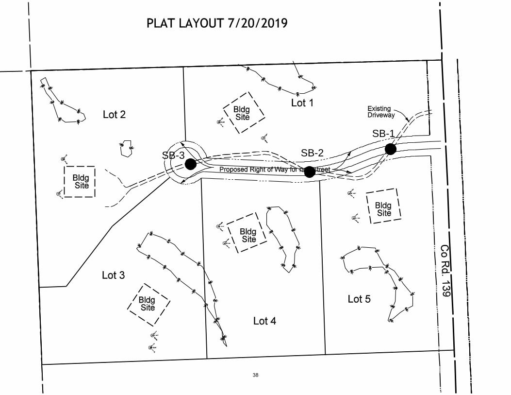
SB-1
SB-2SB-3
38
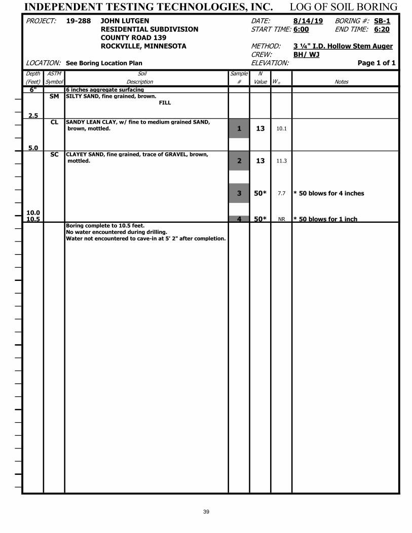
INDEPENDENT TESTING TECHNOLOGIES, INC. LOG OF SOIL BORING PROJECT: 19-288 JOHN LUTGEN DATE: 8/14/19 BORING #: SB-1
RESIDENTIAL SUBDIVISION START TIME: 6:00 END TIME: 6:20COUNTY ROAD 139ROCKVILLE, MINNESOTA METHOD: 3 ¼" I.D. Hollow Stem Auger
CREW: BH/ WJ LOCATION: See Boring Location Plan ELEVATION: Page 1 of 1
Depth ASTM Soil Sample N
(Feet) Symbol Description # Value W n Notes
6" 6 inches aggregate surfacing
SM SILTY SAND, fine grained, brown.FILL
2.5CL SANDY LEAN CLAY, w/ fine to medium grained SAND,
brown, mottled. 1 13 10.1
5.0SC CLAYEY SAND, fine grained, trace of GRAVEL, brown,
mottled. 2 13 11.3
3 50* 7.7 * 50 blows for 4 inches
10.010.5 4 50* NR * 50 blows for 1 inch
Boring complete to 10.5 feet.No water encountered during drilling.Water not encountered to cave-in at 5' 2" after completion.
39

INDEPENDENT TESTING TECHNOLOGIES, INC. LOG OF SOIL BORING PROJECT: 19-288 JOHN LUTGEN DATE: 8/14/19 BORING #: SB-2
RESIDENTIAL SUBDIVISION START TIME: 6:25 END TIME: 6:50COUNTY ROAD 139ROCKVILLE, MINNESOTA METHOD: 3 ¼" I.D. Hollow Stem Auger
CREW: BH/ WJ LOCATION: See Boring Location Plan ELEVATION: Page 1 of 1
Depth ASTM Soil Sample N
(Feet) Symbol Description # Value W n Notes
6" 6 inches aggregate surface
SP-SM POORLY GRADED SAND w/ SILT, fine grained, brown.
FILL
2.5SM SILTY SAND, fine grained, w/ a trace of GRAVEL, brown.
1 26 6.5
5.0
2 46 7.1
3 35 6.5
10.0
4 60 5.7
11.5Boring complete to 11.5 feet.No water encountered during drilling.Water not encountered to cave-in at 5' 2" after completion.
40
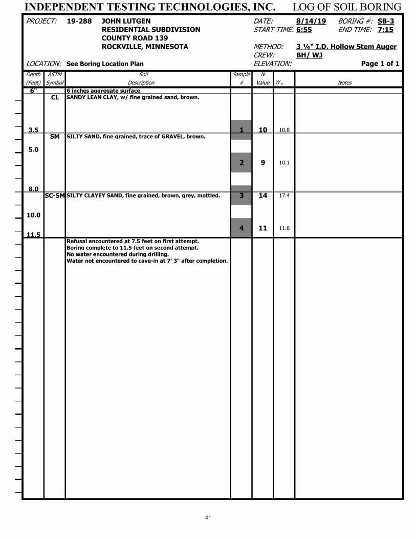
INDEPENDENT TESTING TECHNOLOGIES, INC. LOG OF SOIL BORING PROJECT: 19-288 JOHN LUTGEN DATE: 8/14/19 BORING #: SB-3
RESIDENTIAL SUBDIVISION START TIME: 6:55 END TIME: 7:15COUNTY ROAD 139ROCKVILLE, MINNESOTA METHOD: 3 ¼" I.D. Hollow Stem Auger
CREW: BH/ WJ LOCATION: See Boring Location Plan ELEVATION: Page 1 of 1
Depth ASTM Soil Sample N
(Feet) Symbol Description # Value W n Notes
6" 6 inches aggregate surface
CL SANDY LEAN CLAY, w/ fine grained sand, brown.
3.5 1 10 10.8
SM SILTY SAND, fine grained, trace of GRAVEL, brown.
5.0
2 9 10.1
8.0SC-SM SILTY CLAYEY SAND, fine grained, brown, grey, mottled. 3 14 17.4
10.0
4 11 11.6
11.5Refusal encountered at 7.5 feet on first attempt.Boring complete to 11.5 feet on second attempt.No water encountered during drilling.Water not encountered to cave-in at 7' 3" after completion.
41

42
43
44

Building Permits: September 2019Parcel # REASON ADDRESS DATE PERMIT # Valuation Permit $ Review SSC Fees
76.42142.0000 Siding 25297 Lake Rd 9/6/2019 2019-00058 3,800.00$ 25.00$ -$ 1.00$ 26.00$ 76.42189.0047 Demo Cabin 11063 Hubert Lane 9/18/2019 2019-00059 -$ 25.00$ -$ 1.00$ 26.00$ 76.41629.0500 Plumbing Commercial 23445 Co Rd 8 8/20/2019 2019-00082 11,000.00$ 110.00$ 71.50$ 5.50$ 187.00$ 76.42220.0030 Mechanical Remodel 660 Ptarmigan Dr 9/4/2019 2019-00086 -$ 40.00$ -$ 1.00$ 41.00$ 76.41705.0011 Foundation Only 21273 Agate Beach Rd 9/13/2019 2019-00088 65,000.00$ 357.50$ 232.38$ 320.50$ 622.38$ 76.42170.0039 Single Family New Construction 6049 Scenic View Ct 9/16/2019 2019-00089 380,000.00$ 2,090.00$ 1,358.50$ 190.00$ 3,638.50$ 76.42147.0001 Foundation Only 1640 Prairie Dr 9/16/2019 2019-00090 2,000.00$ 32.50$ 21.13$ 1.00$ 54.63$ 76.42144.0002 Addition 8615 Co Rd 6 9/18/2019 2019-00091 64,300.00$ 353.65$ 229.87$ 32.15$ 615.67$ 76.42147.0001 Mechanical Commercial 1640 Prairie Dr 9/19/2019 2019-00104 4,750.00$ 72.25$ -$ 2.38$ 73.63$ 76.41624.0400 Deck/Porch 8334 Ahles Rd 9/26/2019 2019-00107 1,800.00$ 29.50$ 19.18$ 0.90$ 49.58$
45