ZONING COMMISSION AGENDA - Fort Worth, Texas
82
Zoning Commission Page 1 of 3 February, 10, 2021 Meeting Agenda ZONING COMMISSION AGENDA Wednesday, February 10, 2021 Public Hearing 1:00 PM Videoconference https://fortworthtexas.webex.com/fortworthtexas/onstage/g.php?MTID=e1254d3f2e68130c5658a26dea59 6746c Meeting/ Access Code: 126 249 3762 Registration Required Teleconference (817) 392-1111 or 1-650-479-3208 Meeting/ Access Code: 126 249 3762 Viewing Only Television: Charter 190; One Source 7; Verizon 5; AT&T Uverse 99 City of Fort Worth Website Homepage: Watch Live Online To view the docket for this meeting visit: https://www.fortworthtexas.gov/calendar/boards-commission Due to health and safety concerns related to the COVID-19 coronavirus, this meeting will be conducted by videoconference or telephone call in accordance with the Texas Open Meetings Act and the provisions provided by the Governor of Texas in conjunction with the Declaration of Disaster enacted on March 13, 2020. **Any member of the public who wishes to address the Commission regarding an item on the listed agenda must sign up to speak no later than 5:00PM on Monday February 8th. To sign up, either contact Arturo Wheaton-Rodriguez at [email protected] or (817) 392- 6226 or register through WebEx per the directions on the City’s website above. Please note that the City of Fort Worth is using a third party vendor to assist with City meetings. If there are service interruptions, including call in number changes, we will provide alternative call in numbers on our website whenever possible. COMMISSION MEMBERS: Will Northern, Chair, CD 1 ____ Willie Rankin, CD 2 ____ Beth Welch, CD 3 ____ Jesse Gober, CD 4 ____ Rafael McDonnell, CD 5 ____ Sandra Runnels, CD 6 ____ John Aughinbaugh, CD 7 ____ Wanda Conlin, Vice Chair, CD 8 ____ Kimberly Miller, CD 9 ____ I. PUBLIC HEARING 1:00 PM MEETING WILL ADJOURN AT 5:00 PM (ANY CASES NOT HEARD WILL BE MOVED TO MARCH 10, 2021). CASES HEARD AT THIS PUBLIC HEARING ARE TO BE HEARD AT THE CITY COUNCIL MEETING ON TUESDAY, MARCH 2, 2021 AT 7:00 P.M. UNLESS OTHERWISE STATED. A. Call to Order B. Moment of Silence in Honor of H. Dennis Hopkins and Frank H. Sherwood, Jr. C. Approval of Meeting Minutes of January 13, 2021 _________ Chair
Transcript of ZONING COMMISSION AGENDA - Fort Worth, Texas

Zoning Commission Page 1 of 3 February, 10, 2021 Meeting Agenda
ZONING COMMISSION
AGENDA Wednesday, February 10, 2021
Public Hearing 1:00 PM
Videoconference https://fortworthtexas.webex.com/fortworthtexas/onstage/g.php?MTID=e1254d3f2e68130c5658a26dea59
6746c Meeting/ Access Code: 126 249 3762
Registration Required
Teleconference (817) 392-1111 or 1-650-479-3208
Meeting/ Access Code: 126 249 3762 Viewing Only
Television: Charter 190; One Source 7; Verizon 5; AT&T Uverse 99 City of Fort Worth Website Homepage: Watch Live Online
To view the docket for this meeting visit: https://www.fortworthtexas.gov/calendar/boards-commission Due to health and safety concerns related to the COVID-19 coronavirus, this meeting will be conducted by videoconference or telephone call in accordance with the Texas Open Meetings Act and the provisions provided by the Governor of Texas in conjunction with the Declaration of Disaster enacted on March 13, 2020. **Any member of the public who wishes to address the Commission regarding an item on the listed agenda must sign up to speak no later than 5:00PM on Monday February 8th. To sign up, either contact Arturo Wheaton-Rodriguez at [email protected] or (817) 392-6226 or register through WebEx per the directions on the City’s website above. Please note that the City of Fort Worth is using a third party vendor to assist with City meetings. If there are service interruptions, including call in number changes, we will provide alternative call in numbers on our website whenever possible. COMMISSION MEMBERS: Will Northern, Chair, CD 1 ____ Willie Rankin, CD 2 ____ Beth Welch, CD 3 ____ Jesse Gober, CD 4 ____ Rafael McDonnell, CD 5 ____
Sandra Runnels, CD 6 ____ John Aughinbaugh, CD 7 ____ Wanda Conlin, Vice Chair, CD 8 ____ Kimberly Miller, CD 9 ____
I. PUBLIC HEARING 1:00 PM MEETING WILL ADJOURN AT 5:00 PM (ANY CASES NOT HEARD WILL BE MOVED TO MARCH 10, 2021). CASES HEARD AT THIS PUBLIC HEARING ARE TO BE HEARD AT THE CITY COUNCIL MEETING ON TUESDAY, MARCH 2, 2021 AT 7:00 P.M. UNLESS OTHERWISE STATED. A. Call to Order B. Moment of Silence in Honor of H. Dennis Hopkins and Frank H. Sherwood, Jr. C. Approval of Meeting Minutes of January 13, 2021 _________ Chair
Zoning Commission Page 2 of 3 February, 10, 2021 Meeting Agenda
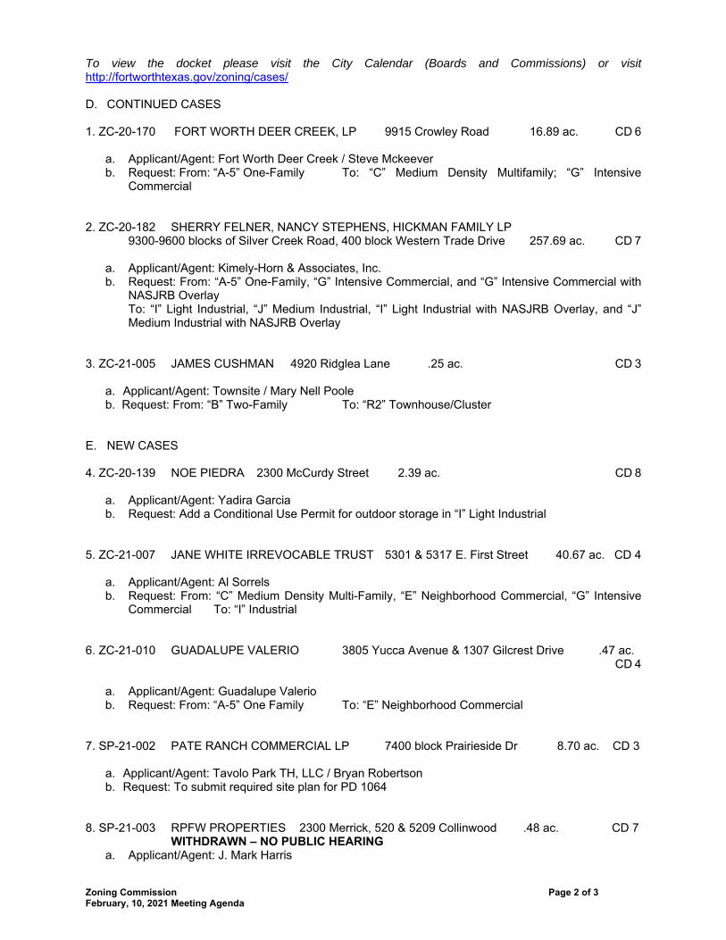
To view the docket please visit the City Calendar (Boards and Commissions) or visit http://fortworthtexas.gov/zoning/cases/ D. CONTINUED CASES 1. ZC-20-170 FORT WORTH DEER CREEK, LP 9915 Crowley Road 16.89 ac. CD 6 a. Applicant/Agent: Fort Worth Deer Creek / Steve Mckeever b. Request: From: “A-5” One-Family To: “C” Medium Density Multifamily; “G” Intensive
Commercial 2. ZC-20-182 SHERRY FELNER, NANCY STEPHENS, HICKMAN FAMILY LP
9300-9600 blocks of Silver Creek Road, 400 block Western Trade Drive 257.69 ac. CD 7 a. Applicant/Agent: Kimely-Horn & Associates, Inc. b. Request: From: “A-5” One-Family, “G” Intensive Commercial, and “G” Intensive Commercial with
NASJRB Overlay To: “I” Light Industrial, “J” Medium Industrial, “I” Light Industrial with NASJRB Overlay, and “J” Medium Industrial with NASJRB Overlay
3. ZC-21-005 JAMES CUSHMAN 4920 Ridglea Lane .25 ac. CD 3 a. Applicant/Agent: Townsite / Mary Nell Poole b. Request: From: “B” Two-Family To: “R2” Townhouse/Cluster E. NEW CASES 4. ZC-20-139 NOE PIEDRA 2300 McCurdy Street 2.39 ac. CD 8 a. Applicant/Agent: Yadira Garcia b. Request: Add a Conditional Use Permit for outdoor storage in “I” Light Industrial 5. ZC-21-007 JANE WHITE IRREVOCABLE TRUST 5301 & 5317 E. First Street 40.67 ac. CD 4 a. Applicant/Agent: Al Sorrels b. Request: From: “C” Medium Density Multi-Family, “E” Neighborhood Commercial, “G” Intensive
Commercial To: “I” Industrial 6. ZC-21-010 GUADALUPE VALERIO 3805 Yucca Avenue & 1307 Gilcrest Drive .47 ac.
CD 4 a. Applicant/Agent: Guadalupe Valerio b. Request: From: “A-5” One Family To: “E” Neighborhood Commercial 7. SP-21-002 PATE RANCH COMMERCIAL LP 7400 block Prairieside Dr 8.70 ac. CD 3 a. Applicant/Agent: Tavolo Park TH, LLC / Bryan Robertson b. Request: To submit required site plan for PD 1064 8. SP-21-003 RPFW PROPERTIES 2300 Merrick, 520 & 5209 Collinwood .48 ac. CD 7
WITHDRAWN – NO PUBLIC HEARING a. Applicant/Agent: J. Mark Harris
Zoning Commission Page 3 of 3 February, 10, 2021 Meeting Agenda
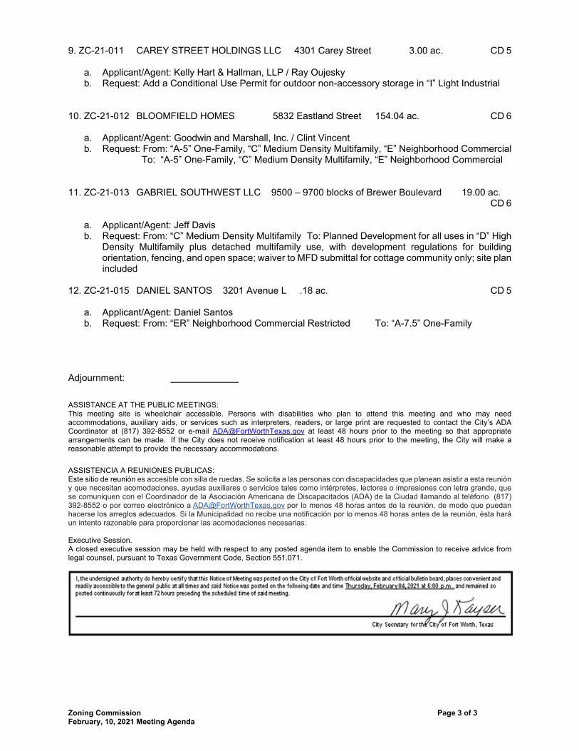
9. ZC-21-011 CAREY STREET HOLDINGS LLC 4301 Carey Street 3.00 ac. CD 5 a. Applicant/Agent: Kelly Hart & Hallman, LLP / Ray Oujesky b. Request: Add a Conditional Use Permit for outdoor non-accessory storage in “I” Light Industrial 10. ZC-21-012 BLOOMFIELD HOMES 5832 Eastland Street 154.04 ac. CD 6 a. Applicant/Agent: Goodwin and Marshall, Inc. / Clint Vincent b. Request: From: “A-5” One-Family, “C” Medium Density Multifamily, “E” Neighborhood Commercial
To: “A-5” One-Family, “C” Medium Density Multifamily, “E” Neighborhood Commercial 11. ZC-21-013 GABRIEL SOUTHWEST LLC 9500 – 9700 blocks of Brewer Boulevard 19.00 ac.
CD 6 a. Applicant/Agent: Jeff Davis b. Request: From: “C” Medium Density Multifamily To: Planned Development for all uses in “D” High
Density Multifamily plus detached multifamily use, with development regulations for building orientation, fencing, and open space; waiver to MFD submittal for cottage community only; site plan included
12. ZC-21-015 DANIEL SANTOS 3201 Avenue L .18 ac. CD 5 a. Applicant/Agent: Daniel Santos b. Request: From: “ER” Neighborhood Commercial Restricted To: “A-7.5” One-Family Adjournment: ASSISTANCE AT THE PUBLIC MEETINGS: This meeting site is wheelchair accessible. Persons with disabilities who plan to attend this meeting and who may need accommodations, auxiliary aids, or services such as interpreters, readers, or large print are requested to contact the City’s ADA Coordinator at (817) 392-8552 or e-mail [email protected] at least 48 hours prior to the meeting so that appropriate arrangements can be made. If the City does not receive notification at least 48 hours prior to the meeting, the City will make a reasonable attempt to provide the necessary accommodations.
ASSISTENCIA A REUNIONES PUBLICAS: Este sitio de reunión es accesible con silla de ruedas. Se solicita a las personas con discapacidades que planean asistir a esta reunión y que necesitan acomodaciones, ayudas auxiliares o servicios tales como intérpretes, lectores o impresiones con letra grande, que se comuniquen con el Coordinador de la Asociación Americana de Discapacitados (ADA) de la Ciudad llamando al teléfono (817) 392-8552 o por correo electrónico a [email protected] por lo menos 48 horas antes de la reunión, de modo que puedan hacerse los arreglos adecuados. Si la Municipalidad no recibe una notificación por lo menos 48 horas antes de la reunión, ésta hará un intento razonable para proporcionar las acomodaciones necesarias. Executive Session. A closed executive session may be held with respect to any posted agenda item to enable the Commission to receive advice from legal counsel, pursuant to Texas Government Code, Section 551.071.
CITY OF FORT WORTH, TEXAS
ZONING HEARING February 10, 2021
Page 1 of 2
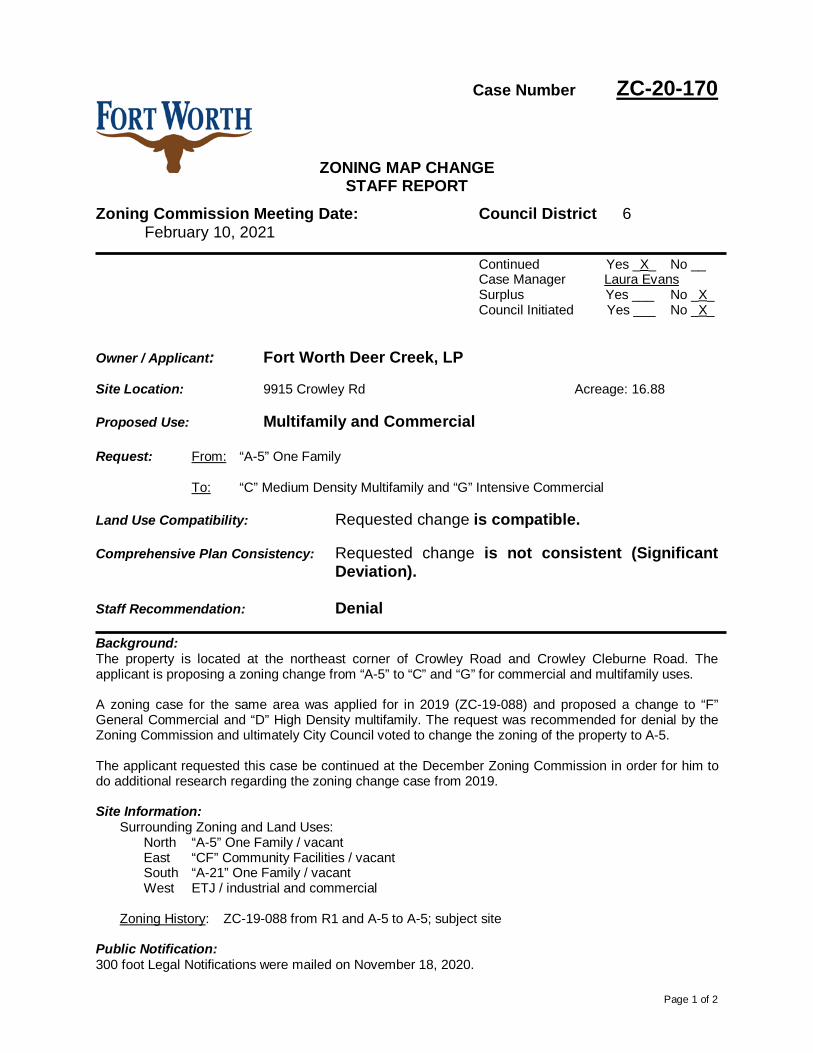
Case Number ZC-20-170
ZONING MAP CHANGE STAFF REPORT
Zoning Commission Meeting Date: Council District 6 February 10, 2021
Continued Yes _X_ No __ Case Manager Laura Evans Surplus Yes ___ No _X_ Council Initiated Yes ___ No _X_
Owner / Applicant: Fort Worth Deer Creek, LP Site Location: 9915 Crowley Rd Acreage: 16.88 Proposed Use: Multifamily and Commercial Request: From: “A-5” One Family
To: “C” Medium Density Multifamily and “G” Intensive Commercial
Land Use Compatibility: Requested change is compatible. Comprehensive Plan Consistency: Requested change is not consistent (Significant
Deviation). Staff Recommendation: Denial Background: The property is located at the northeast corner of Crowley Road and Crowley Cleburne Road. The applicant is proposing a zoning change from “A-5” to “C” and “G” for commercial and multifamily uses. A zoning case for the same area was applied for in 2019 (ZC-19-088) and proposed a change to “F” General Commercial and “D” High Density multifamily. The request was recommended for denial by the Zoning Commission and ultimately City Council voted to change the zoning of the property to A-5. The applicant requested this case be continued at the December Zoning Commission in order for him to do additional research regarding the zoning change case from 2019. Site Information:
Surrounding Zoning and Land Uses: North “A-5” One Family / vacant East “CF” Community Facilities / vacant South “A-21” One Family / vacant West ETJ / industrial and commercial
Zoning History: ZC-19-088 from R1 and A-5 to A-5; subject site
Public Notification: 300 foot Legal Notifications were mailed on November 18, 2020.

Page 2 of 2
The following organizations were notified: (emailed November 16, 2020) Organizations Notified
The Clark Road NA Parkview HOA* District 6 Alliance Streams And Valleys Inc Trinity Habitat for Humanity Crowley ISD *Closest registered neighborhood organization
Development Impact Analysis:
1. Land Use Compatibility The applicant is proposing a zoning change to “C” and “G” for commercial and multifamily uses. Surrounding land uses consist of primarily undeveloped land with commercial and industrial uses to the west. The proposed zoning is compatible with surrounding land uses.
2. Comprehensive Plan Consistency
The 2020 Comprehensive Plan designates the subject property as Low Density Residential and Institutional. The proposed zonings are not compatible with the future land uses of the property. The below Comprehensive Plan policies apply to this proposal: • Promote location of multifamily units within walking distance of public transportation,
employment, recreation, and/or shopping to increase accessibility and decrease vehicular traffic generation.
• Separate incompatible land uses with buffers or transitional uses. Some land uses have attributes such as height, proportion, scale, operational characteristics, traffic generated, or appearance that may not be compatible with the attributes of other uses.
Based on the conformance with the future land use map and policies stated above, the proposed zoning is not consistent (Significant Deviation) with the Comprehensive Plan.
Attachments:
• Area Zoning Map with 300 ft. Notification Area • Area Map • Future Land Use Map • Aerial Photograph

0 440 880220 Feet
Area Zoning Map
ZC-20-170
Applicant: Address:Zoning From:Zoning To:Acres:Mapsco:Sector/District:Commission Date:Contact:
Fort Worth Deer Creek, LP
104UX16.88146225C, GA-59915 Crowley Road
817-392-804312/9/2020Far South
Created: 11/17/2020 10:30:57 AM
Subject Area300 Foot Notification
Ü

0 2,000 4,0001,000 Feet
Area Map
ZC-20-170
Created: 11/17/2020 10:30:19 AMÜ
CONSERVATION DISTRICT
Overlay DistrictsAirport Overlay DistrictI-35WTU PERIPHERALDESIGN DISTRICT
Noise ContoursDECIBEL
6570758085
Council Districts
4 - Cary M oon5 - Gyna B ivens6 - Jungus Jordan7 - Dennis Shingleton8 - Kelly Allen Gray9 - Ann Zadeh
3 - B rian Byrd2 - Carlos E. Flo res
600 0 600300 FeetA Com prehens iv e P lan shall not c ons titu te z oning r egulations ores tab l is h z oning d istrict boundaries . (Texas Loc al Governm ent Code, S ection 213.005.) Land use des ignations were approv ed by City Counci l on M arc h 6, 2018.
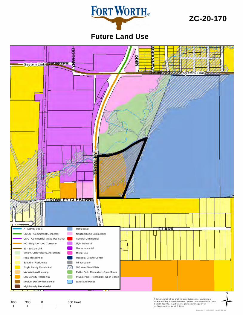
Future Land Use
ZC-20-170
Cr eated: 11/17/2020 10:31:38 AMÜ
Vacant, Undeveloped, AgriculturalRural ResidentialSuburban ResidentialSingle Family ResidentialManufactured HousingLow Density Res ident ialMedium Density ResidentialHigh Density R esident ial
InstitutionalNeighborhood CommercialGeneral CommercialLight Indus trialHeavy IndustrialMixed-UseIndustrial Growth CenterInfras truc ture100 Year Flood PlainPublic Park, Recreation, Open SpacePrivate Park, Recreat ion, Open SpaceLakes and Ponds
CMU - Commercial Mixed Use StreetNC - Neighborhood Connector
A - Ac tivity StreetCMCO - Commerc ial C onnec tor
SL - System Link

0 750 1,500375 Feet
Aerial Photo Map
ZC-20-170
Ü
Page 1 of 3
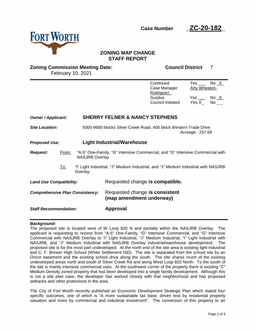
Case Number _ZC-20-182_
ZONING MAP CHANGE STAFF REPORT
Zoning Commission Meeting Date: Council District 7 February 10, 2021
Continued Yes ___ No _X_ Case Manager Arty Wheaton-Rodriguez_ Surplus Yes ___ No _X_ Council Initiated Yes X_ No _ _
Owner / Applicant: SHERRY FELNER & NANCY STEPHENS Site Location: 9300-9600 blocks Silver Creek Road, 400 block Western Trade Drive Acreage: 257.69 Proposed Use: Light Industrial/Warehouse Request: From: “A-5” One-Family, “G” Intensive Commercial, and “G” Intensive Commercial with
NASJRB Overlay
To: “I” Light Industrial, “J” Medium Industrial, and “J” Medium Industrial with NASJRB Overlay
Land Use Compatibility: Requested change is compatible. Comprehensive Plan Consistency: Requested change is consistent
(map amendment underway)
Staff Recommendation: Approval
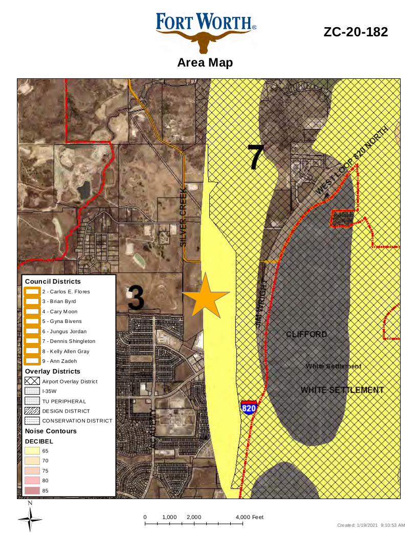
Background: The proposed site is located west of W Loop 820 N and partially within the NASJRB Overlay. The applicant is requesting to rezone from “A-5” One-Family, “G” Intensive Commercial, and “G” Intensive Commercial with NASJRB Overlay to “I” Light Industrial, “J” Medium Industrial, “I” Light Industrial with NASJRB, and “J” Medium Industrial with NASJRB Overlay industrial/warehouse development. The proposed site is for the most part undeveloped. At the north end of the site area is existing light industrial and C. F. Brewer High School (White Settlement ISD). The site is separated from the school site by an Oncor easement and the existing school drive along the south. The site shares much of the existing undeveloped areas north and south of Silver Creek Rd and along West Loop 820 North. To the south of the site is mainly intensive commercial uses. At the southwest corner of the property there is existing “C” Medium Density zoned property that has been developed into a single family development. Although this is not a site plan case, the developer has worked closely with that neighborhood and has proposed setbacks and other protections in the area. The City of Fort Worth recently published an Economic Development Strategic Plan which stated four specific outcomes, one of which is “A more sustainable tax base, driven less by residential property valuation and more by commercial and industrial investment”. The conversion of this property to an
Page 2 of 3
industrial zoned one allows for the continued diversification of the tax base and provides industrial development along W Loop 820 N. Site Information:
Surrounding Zoning and Land Uses:
North “A-5” One-Family / vacant, immediate parcel to the north owned by White Settlement ISD East Freeway ROW South “J” Medium Industrial, “G” Intensive Commercial, “C” Medium Density Multifamily/ existing large scale retail and a single family development West “AG” Agricultural / existing agricultural use, gas well, vacant
Recent Relevant Zoning and Platting History:
Zoning History: None
Public Notification: 300 foot Legal Notifications were mailed on January 21, 2020. The following organizations were notified: (emailed January 19, 2020)
Organizations Notified NA on South Lake Worth Fort Worth ISD NAS Fort Worth JRB RCC White Settlement ISD Trinity Habitat for Humanity Streams and Valleys Inc.
Development Impact Analysis:
1. Land Use Compatibility The applicant is requesting to rezone from “A-5” One-Family “G” Intensive Commercial to “I” Light Industrial and “J” Medium Industrial for industrial/warehouse development. Silver Creek Road becomes the main spine for the development and has direct access to W Loop 820 N. The site area is mainly undeveloped with the eastern boundary being the freeway and the western boundary being agricultural zoning. The areas where there is residential adjacency are few with the closest existing residential development sharing a small boundary with the site. There are intensive commercial uses separating most of the site from the existing established single family to the south. As a result, the proposed "I" Light Industrial zoning is compatible at this location.
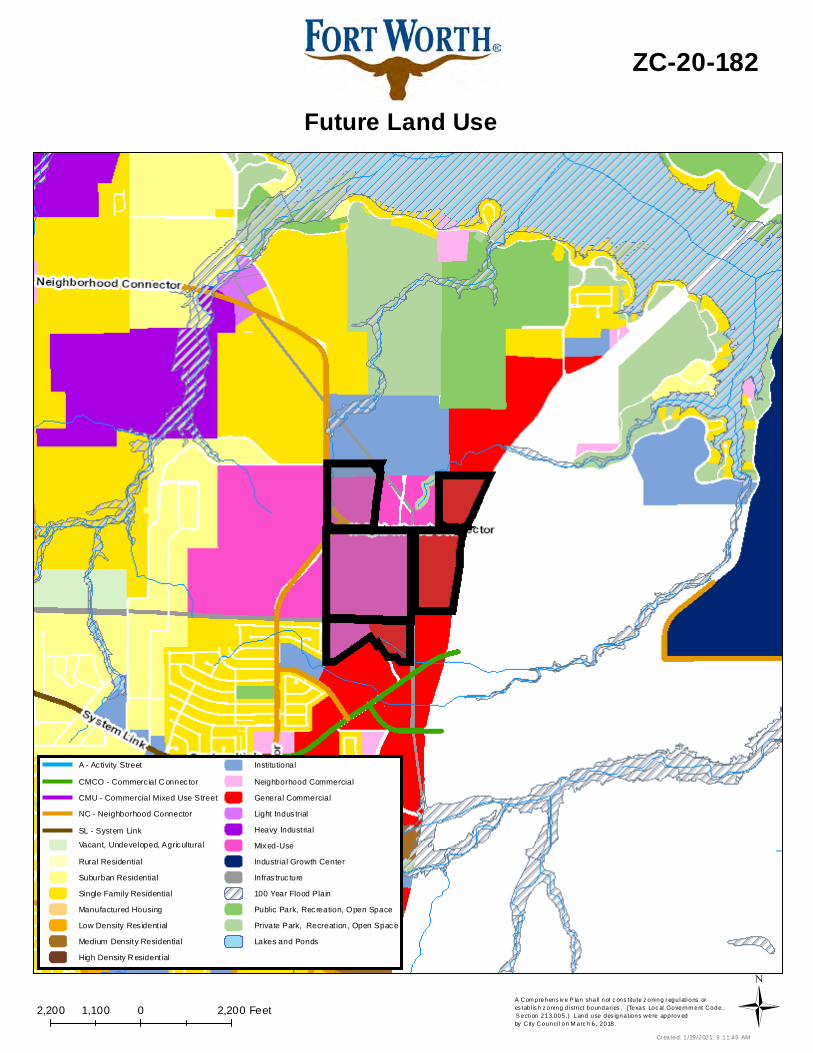
2. Comprehensive Plan Consistency-Far West
The 2020 Comprehensive Plan designates the subject property as Mixed-Use Growth Center. The proposed “I” Light Industrial zoning district, which is typically not seen as an appropriate zoning classification to promote growth in a Mixed-Use Growth Center. In this case, Staff has identified this area as one in need of a map amendment. That map amendment is currently underway." This site is supported by various Comprehensive Plan Policies based on its location and proximity to the freeway. • Identify and designate on future land use maps new industrial growth centers in rapidly
developing areas, based on proximity to existing infrastructure and key transportation intersections.
• Locate large industrial uses along freight lines, highways, or airports within industrial growth centers and other appropriate locations.
Based on conformance with the future land use map and policies stated above, the proposed zoning is consistent with the Comprehensive Plan (map amendment underway). Staff recommends designating the Future land Use area as Light Industrial, which is a change currently in process.
Page 3 of 3
3. Economic Development Strategic Plan
The 2018 Economic Development Strategic Plan identified a vision, goals, and strategies in order to facilitate the success and growth of the City of Fort Worth. The Plan includes performance metrics that place an emphasis on outcomes that create: • High-wage job growth. • A more sustainable tax base, driven less by residential property valuation and more by
commercial and industrial investment. • An economy that capitalizes on high-growth industries and the creative individuals who fuel
them. • A commitment to “quality of place” throughout the community.
Attachments:
• Area Zoning Map with 300 ft. Notification Area • Area Map • Future Land Use Map • Aerial Photograph • Zoning Exhibit
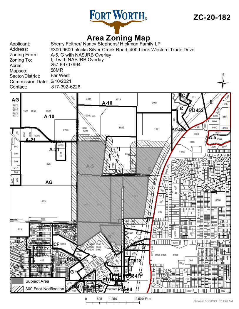
0 1,250 2,500625 Feet
Area Zoning Map
ZC-20-182
Applicant: Address:Zoning From:Zoning To:Acres:Mapsco:Sector/District:Commission Date:Contact:
Sherry Feltner/ Nancy Stephens/ Hickman Family LP
58MR257.69707994I, J with NASJRB OverlayA-5, G with NASJRB Overlay9300-9600 blocks Silver Creek Road, 400 block Western Trade Drive
817-392-62262/10/2021Far West
Created: 1/19/2021 9:11:26 AM
Subject Area300 Foot Notification
Ü
0 2,000 4,0001,000 Feet
Area Map
ZC-20-182
Created: 1/19/2021 9:10:53 AMÜ
CONSERVATION DISTRICT
Overlay DistrictsAirport Overlay DistrictI-35WTU PERIPHERALDESIGN DISTRICT
Noise ContoursDECIBEL
6570758085
Council Districts
4 - Cary M oon5 - Gyna B ivens6 - Jungus Jordan7 - Dennis Shingleton8 - Kelly Allen Gray9 - Ann Zadeh
3 - B rian Byrd2 - Carlos E. Flo res
2,200 0 2,2001,100 FeetA Com prehens iv e P lan shall not c ons titu te z oning r egulations ores tab l is h z oning d istrict boundaries . (Texas Loc al Governm ent Code, S ection 213.005.) Land use des ignations were approv ed by City Counci l on M arc h 6, 2018.
Future Land Use
ZC-20-182
Cr eated: 1 /19/2021 9 :11:45 AMÜ
Vacant, Undeveloped, AgriculturalRural ResidentialSuburban ResidentialSingle Family ResidentialManufactured HousingLow Density Res ident ialMedium Density ResidentialHigh Density R esident ial
InstitutionalNeighborhood CommercialGeneral CommercialLight Indus trialHeavy IndustrialMixed-UseIndustrial Growth CenterInfras truc ture100 Year Flood PlainPublic Park, Recreation, Open SpacePrivate Park, Recreat ion, Open SpaceLakes and Ponds
CMU - Commercial Mixed Use StreetNC - Neighborhood Connector
A - Ac tivity StreetCMCO - Commerc ial C onnec tor
SL - System Link

0 2,900 5,8001,450 Feet
Aerial Photo Map
ZC-20-182
Ü
CLIFFORD STREET
PAR
T 1
STAT
E O
F TE
XAS
VOL.
522
1, P
G. 7
07D
.R.T
.C.T
.
OSPREYDRIVE
CH
ICKA
DEE
DR
IVE
SPARROWHAWK DRIVE
STATE OF TEXASVOL. 5199, PG. 149
D.R.T.C.T.
STATE OF TEXASVOL. 5221, PG. 728
D.R.T.C.T.
INTE
RSTA
TE L
OO
P 82
0
(VAR
IABL
E W
IDTH
R.O
.W.)
(VARIABLE WIDTH R.O.W
.)
INTE
RST
ATE
LOO
P 82
0(V
ARIA
BLE
WID
TH R
.O.W
.)
TRACT 247.802 ACRES
2,082,259 SQ. FT.
TRACT 1142.755 ACRES
6,218,413 SQ. FT.
INTE
RST
ATE
LOO
P 82
0(V
ARIA
BLE
WID
TH R
.O.W
.)
WESTERN TRADE DRIVE
(VARIABLE WIDTH R.O.W
.)
TRACT 1142.755 ACRES
6,218,413 SQ. FT.
SILVER CREEK ROAD(COUNTY ROAD NO. 1031)(VARIABLE WIDTH R.O.W.)
SILVER CREEK ROAD(COUNTY ROAD NO. 1031)(VARIABLE WIDTH R.O.W.)
CAL
LED
9.8
83 A
CST
ATE
OF
TEXA
SVO
L. 5
146,
PG
. 855
D.R
.T.C
.T.
CITY OF FORT WORTHINST. NO. D211236293
D.R.T.C.T.
WESTER
N TR
ADE D
RIVE
60' R.O
.W.)
EXISTING ZONING:I - LIGHT INDUSTRIAL
PROPOSED ZONING:I - LIGHT INDUSTRIAL
PROPOSED ZONING:J - MEDIUM INDUSTRIAL
PROPOSED ZONING:J - MEDIUM INDUSTRIAL
PROPOSED ZONING:I - LIGHT INDUSTRIAL
EXISTING ZONING:G - GENERALCOMMERCIAL
EXISTING ZONING:J - MEDIUM
INDUSTRIAL
EXISTING ZONING:G - GENERALCOMMERCIAL
TRACT 613.284 AC.
TRACT 52.9339 AC.
TRACT 41.8325 AC.
TRACT 3.220.517 AC.
TRACT 3.1
TRACT 2TRACT 1.1
TRACT 1.2
38.068 AC.
102.119 AC. 47.802 AC.
26.870 AC.
PROPOSED ZONING:I - LIGHT INDUSTRIAL
STEPHENS 1.1
43.304 AC.
STEPHENS 1.20.117 AC.
DWG NAME K:\FTW_CIVIL\061282621 - MAJESTIC SILVER CREEK\CAD\EXHIBITS\ZONING EXHIBIT.DWGLAST SAVED 12/10/2020 11:19 AM
NOTE: THIS PLAN IS CONCEPTUAL IN NATURE AND HAS BEEN PRODUCED WITHOUT THE BENEFIT OF A SURVEY,TOPOGRAPHY, UTILITIES, CONTACT WITH THE CITY, ETC.
801 Cherry Street, Unit 11Suite 1300Fort Worth, TX 76102817-335-6511State of Texas Registration No. F-928
MAJESTIC SILVER CREEKZONING EXHIBITFORT WORTH, TXDECEMBER 2020
NORTH
Page 1 of 2
Case Number _ZC-20-005
ZONING MAP CHANGE STAFF REPORT
Zoning Commission Meeting Date: Council District 3 February 10, 2021
Continued Yes _X_ No ___ Case Manager Monica Lafitte___ Surplus Yes ___ No _X_ Council Initiated Yes ___ No _X_
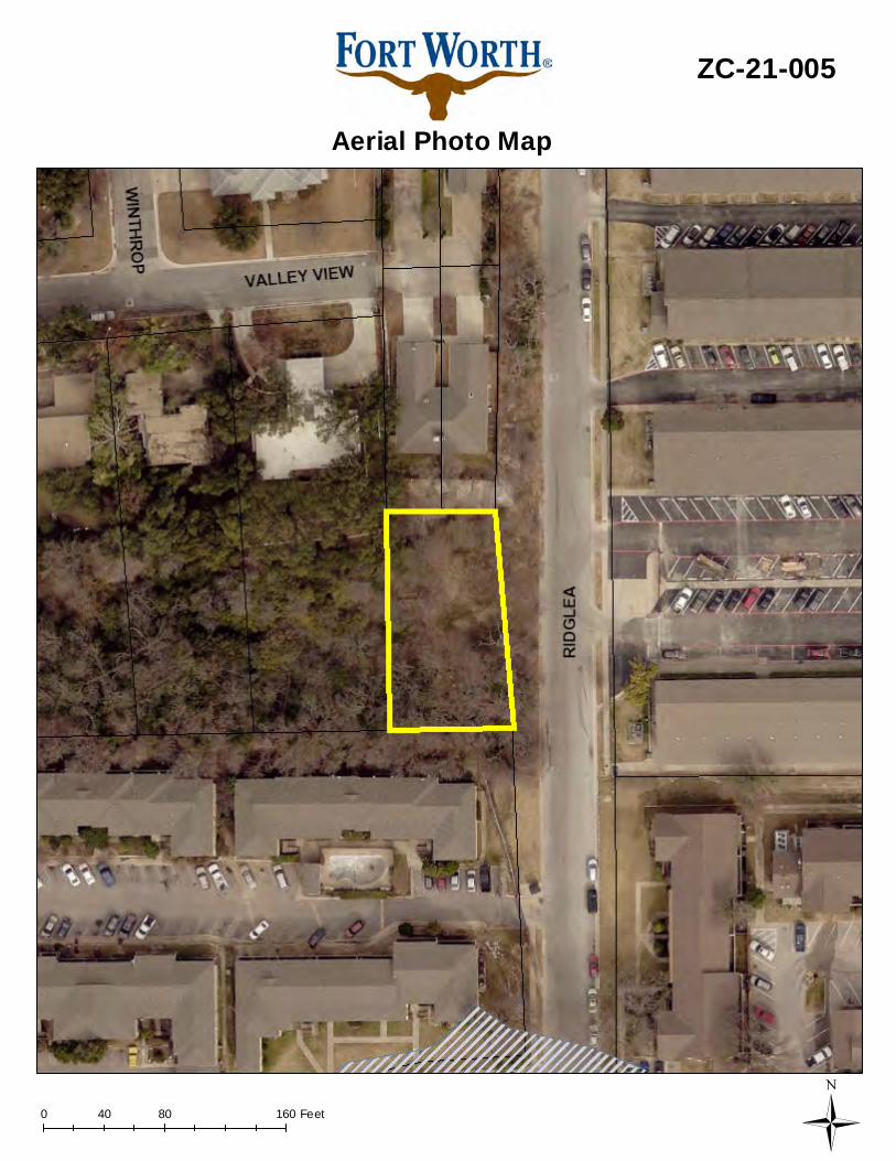
Owner / Applicant: James M. Cushman Site Location: 4920 Ridglea Lane Acreage: .31 Proposed Use: Townhomes Request: From: “B” Two-Family
To: “R2” Townhouse/Cluster
Land Use Compatibility: Requested change is compatible. Comprehensive Plan Consistency: Requested change is consistent. Staff Recommendation: Approval Background: The proposed site is located along the west side of Ridglea Lane, in the northwest quadrant of Bryant Irvin Road and W Vickery Boulevard. The applicant is proposing to rezone from “B” Two-Family to “R2” Townhouse/Cluster for a townhouse development. Because “R2” Townhouse/Cluster can be smaller lot developments, they often will be lots less than 50’ in width, which would therefore require rear access per the subdivision ordinance. This zoning case was continued for 30 days at the January 13 Zoning Commission meeting to allow the applicant more time to work with the surrounding neighborhood. The neighborhood requested more details, such as line of sight information. Site Information:
Surrounding Zoning and Land Uses: North “C” Medium Density Multifamily / residential East “C” Medium Density Multifamily / multifamily South “C” Medium Density Multifamily / multifamily West “A-10” One-Family / single-family
Recent Relevant Zoning History:
Zoning History: None
Page 2 of 2
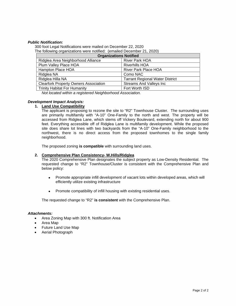
Public Notification:
300 foot Legal Notifications were mailed on December 22, 2020 The following organizations were notified: (emailed December 21, 2020)
Organizations Notified Ridglea Area Neighborhood Alliance River Park HOA Plum Valley Place HOA Riverhills HOA Hampton Place HOA River Park Place HOA Ridglea NA Como NAC Ridglea Hilla NA Tarrant Regional Water District Clearfork Property Owners Association Streams And Valleys Inc Trinity Habitat For Humanity Fort Worth ISD
Not located within a registered Neighborhood Association. Development Impact Analysis:
1. Land Use Compatibility The applicant is proposing to rezone the site to “R2” Townhouse Cluster. The surrounding uses are primarily multifamily with “A-10” One-Family to the north and west. The property will be accessed from Ridglea Lane, which stems off Vickery Boulevard, extending north for about 900 feet. Everything accessible off of Ridglea Lane is multifamily development. While the proposed site does share lot lines with two backyards from the “A-10” One-Family neighborhood to the northwest, there is no direct access from the proposed townhomes to the single family neighborhood. The proposed zoning is compatible with surrounding land uses.
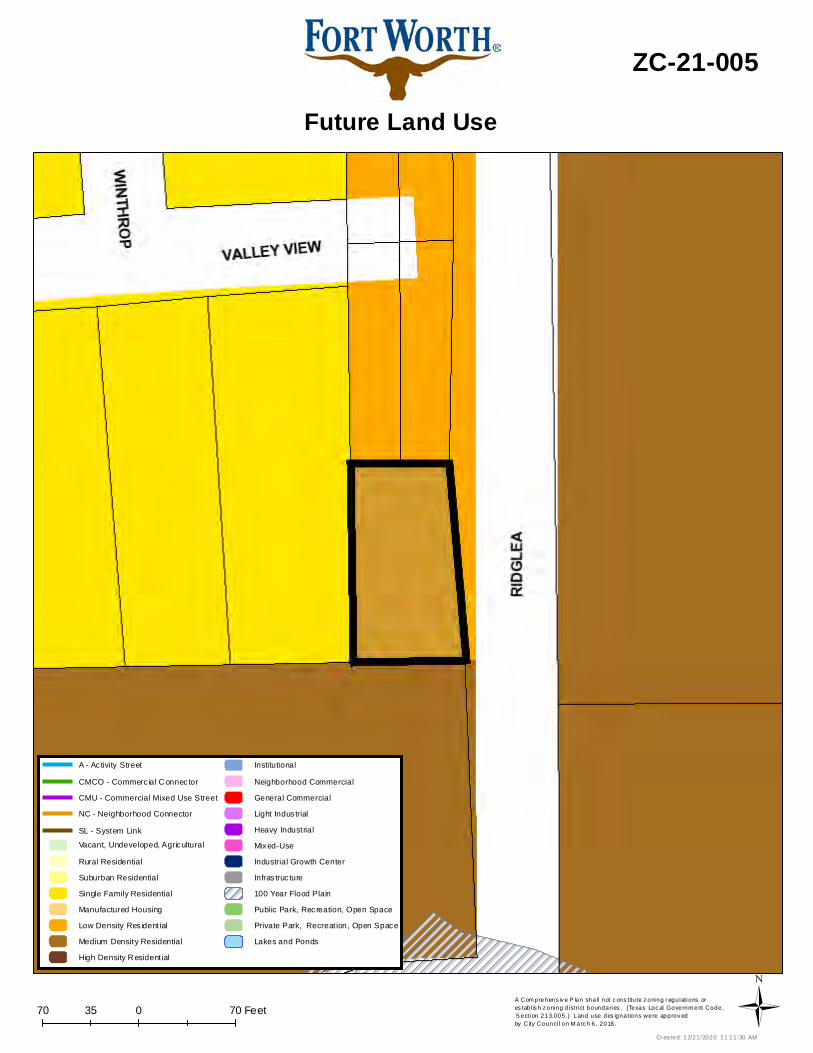
2. Comprehensive Plan Consistency- W.Hills/Ridglea
The 2020 Comprehensive Plan designates the subject property as Low-Density Residential. The requested change to “R2” Townhouse/Cluster is consistent with the Comprehensive Plan and below policy:
• Promote appropriate infill development of vacant lots within developed areas, which will efficiently utilize existing infrastructure
• Promote compatibility of infill housing with existing residential uses. The requested change to “R2” is consistent with the Comprehensive Plan.
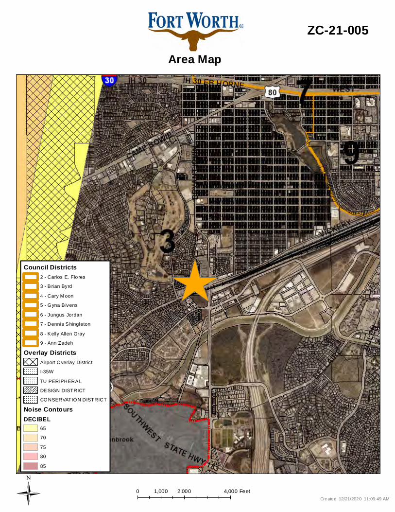
Attachments:
• Area Zoning Map with 300 ft. Notification Area • Area Map • Future Land Use Map • Aerial Photograph
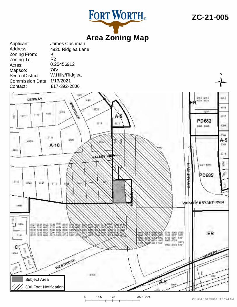
0 175 35087.5 Feet
Area Zoning Map
ZC-21-005
Applicant: Address:Zoning From:Zoning To:Acres:Mapsco:Sector/District:Commission Date:Contact:
James Cushman
74V0.25456912R2B4920 Ridglea Lane
817-392-28061/13/2021W.Hills/Ridglea
Created: 12/21/2020 11:10:44 AM
Subject Area300 Foot Notification
Ü
0 2,000 4,0001,000 Feet
Area Map
ZC-21-005
Created: 12/21/2020 11:09:49 AMÜ
CONSERVATION DISTRICT
Overlay DistrictsAirport Overlay DistrictI-35WTU PERIPHERALDESIGN DISTRICT
Noise ContoursDECIBEL
6570758085
Council Districts
4 - Cary M oon5 - Gyna B ivens6 - Jungus Jordan7 - Dennis Shingleton8 - Kelly Allen Gray9 - Ann Zadeh
3 - B rian Byrd2 - Carlos E. Flo res
70 0 7035 FeetA Com prehens iv e P lan shall not c ons titu te z oning r egulations ores tab l is h z oning d istrict boundaries . (Texas Loc al Governm ent Code, S ection 213.005.) Land use des ignations were approv ed by City Counci l on M arc h 6, 2018.
Future Land Use
ZC-21-005
Cr eated: 12/21/2020 11:11:30 AMÜ
Vacant, Undeveloped, AgriculturalRural ResidentialSuburban ResidentialSingle Family ResidentialManufactured HousingLow Density Res ident ialMedium Density ResidentialHigh Density R esident ial
InstitutionalNeighborhood CommercialGeneral CommercialLight Indus trialHeavy IndustrialMixed-UseIndustrial Growth CenterInfras truc ture100 Year Flood PlainPublic Park, Recreation, Open SpacePrivate Park, Recreat ion, Open SpaceLakes and Ponds
CMU - Commercial Mixed Use StreetNC - Neighborhood Connector
A - Ac tivity StreetCMCO - Commerc ial C onnec tor
SL - System Link
0 80 16040 Feet
Aerial Photo Map
ZC-21-005
Ü
Page 1 of 4
Case Number _ZC-20-139_
ZONING MAP CHANGE STAFF REPORT
Zoning Commission Meeting Date: Council District 8 February 10, 2021
Continued Yes __ No _X_ Case Manager Beth Knight__ Surplus Yes ___ No _X_ Council Initiated Yes ___ No _X
Owner / Applicant: Noe Piedra Site Location: 2300 McCurdy Street Mapsco: 77R Proposed Use: Outdoor storage Request: From: “I” Light Industrial
To: Add Conditional Use Permit to allow outdoor storage with waivers to the supplemental setback, landscaping, and fencing
Land Use Compatibility: Requested change is not compatible. Comprehensive Plan Consistency: Requested change is not consistent. Staff Recommendation: Denial Background: The site is on the southwest corner of McCurdy Street and E. Arlington Avenue and is the only industrial use on the block face. Residential districts are directly west and south of the site. The applicant is requesting to add a Conditional Use Permit to continue outdoor storage with waivers to the supplemental and landscaping setbacks, as well as the screening fence materials. The site plan shows continued use of unpermitted structures. Outdoor storage is only permitted within “I” Light Industrial zoning districts through the CUP process. The applicant has indicated the site has outdoor storage with four buildings with approximately 5,700 square feet. Required screening fencing is required to be a wood or masonry fence, instead of a metal panel fence. Additional waivers are requested for the existing buildings placed in the 50-foot supplemental setback and without the required 20-foot landscaping buffer on the site’s southern and western sides. The area is being used as an informal concrete storage yard, lacking a primary building, with no defined parking spaces or driveways. The site has received Code Compliance complaints dating from 2009 for an illegal land use. All structures and fencing on the site have been constructed from 2009 to 2017 without any building permits that would have allowed utilities to be provided legally to the site. The larger buildings on the south and west property lines were constructed 5 feet from the respective property lines within the supplemental setbacks, where 50 feet is the minimum distance required for buildings adjacent to residential zoning. The aerial photographs also show items stored within the supplemental setback. Buildings, parking, and outdoor storage are also in the 20-foot landscape buffer.
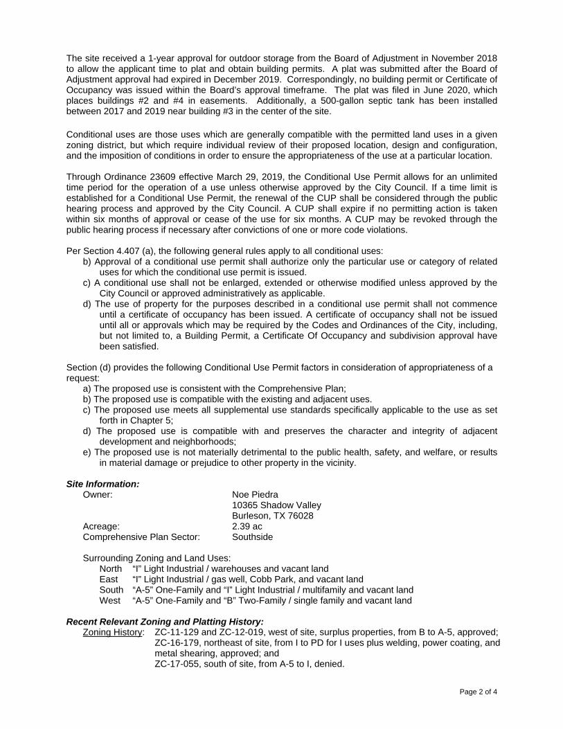
Page 2 of 4
The site received a 1-year approval for outdoor storage from the Board of Adjustment in November 2018 to allow the applicant time to plat and obtain building permits. A plat was submitted after the Board of Adjustment approval had expired in December 2019. Correspondingly, no building permit or Certificate of Occupancy was issued within the Board’s approval timeframe. The plat was filed in June 2020, which places buildings #2 and #4 in easements. Additionally, a 500-gallon septic tank has been installed between 2017 and 2019 near building #3 in the center of the site. Conditional uses are those uses which are generally compatible with the permitted land uses in a given zoning district, but which require individual review of their proposed location, design and configuration, and the imposition of conditions in order to ensure the appropriateness of the use at a particular location. Through Ordinance 23609 effective March 29, 2019, the Conditional Use Permit allows for an unlimited time period for the operation of a use unless otherwise approved by the City Council. If a time limit is established for a Conditional Use Permit, the renewal of the CUP shall be considered through the public hearing process and approved by the City Council. A CUP shall expire if no permitting action is taken within six months of approval or cease of the use for six months. A CUP may be revoked through the public hearing process if necessary after convictions of one or more code violations. Per Section 4.407 (a), the following general rules apply to all conditional uses:
b) Approval of a conditional use permit shall authorize only the particular use or category of related uses for which the conditional use permit is issued.
c) A conditional use shall not be enlarged, extended or otherwise modified unless approved by the City Council or approved administratively as applicable.
d) The use of property for the purposes described in a conditional use permit shall not commence until a certificate of occupancy has been issued. A certificate of occupancy shall not be issued until all or approvals which may be required by the Codes and Ordinances of the City, including, but not limited to, a Building Permit, a Certificate Of Occupancy and subdivision approval have been satisfied.
Section (d) provides the following Conditional Use Permit factors in consideration of appropriateness of a request:
a) The proposed use is consistent with the Comprehensive Plan; b) The proposed use is compatible with the existing and adjacent uses. c) The proposed use meets all supplemental use standards specifically applicable to the use as set
forth in Chapter 5; d) The proposed use is compatible with and preserves the character and integrity of adjacent
development and neighborhoods; e) The proposed use is not materially detrimental to the public health, safety, and welfare, or results
in material damage or prejudice to other property in the vicinity. Site Information:
Owner: Noe Piedra 10365 Shadow Valley Burleson, TX 76028
Acreage: 2.39 ac Comprehensive Plan Sector: Southside Surrounding Zoning and Land Uses:
North “I” Light Industrial / warehouses and vacant land East “I” Light Industrial / gas well, Cobb Park, and vacant land South “A-5” One-Family and “I” Light Industrial / multifamily and vacant land West “A-5” One-Family and “B” Two-Family / single family and vacant land
Recent Relevant Zoning and Platting History: Zoning History: ZC-11-129 and ZC-12-019, west of site, surplus properties, from B to A-5, approved; ZC-16-179, northeast of site, from I to PD for I uses plus welding, power coating, and
metal shearing, approved; and ZC-17-055, south of site, from A-5 to I, denied.

Page 3 of 4
Platting History: FS-18-191, northeast of subject, Graham Park Addition. FS-19-196, subject site, Sycamore Central Industrial Park Addition, filed 6-9-2020.
Site Plan Comments:
The site plan as submitted is not in general compliance with the Zoning Ordinance regulations. 1. Solid screening fencing of wood, brick, stone or reinforced concrete products required around site.
The applicant has requested to keep existing metal panel fence. (waiver required) 2. Structures and any nonresidential activity are not allowed in the 50-foot supplemental setback.
The applicant is requesting two existing buildings, outdoor storage, and parking to remain in 50-foot supplemental setback. (waiver required)
3. A 20-foot landscaped bufferyard is required when a vacant lot adjacent to a residential district is converted to a non-residential use. The applicant is requesting two existing buildings, outdoor storage, and parking to remain in 20-foot landscaped bufferyard. (waiver required)
4. Locations of existing outdoor storage not shown on site plan. 5. The 20-foot landscaped buffer is not shown along the southern and eastern property lines. 6. Note the name, address, and telephone number of the engineer/ architect/ surveyor/ planner.
Platting site plan comments - none Transportation/Public Works (TPW) site plan comments:
1. Show the dimensions of all existing or recorded streets, alleys, easements, railroad ROW, or other public ROW within or adjacent to the subdivision boundaries. The distance from the centerline of the existing roadway of the boundary street to the proposed property line shall be shown. 2. Show distance(s) from property corner(s) to nearest identifiable street, railroad or other intersection. 3. Label Plat - Show Case Number on the plat. (But not as part of title block). 4. Sidewalk Note – A 6ft. sidewalk is required along all street frontages.
Fire comments - It is the applicant's and the owner's responsibility to meet all minimum fire code requirements at all times. Park & Recreation site plan comments - none Water site plan comments - Site can be served by both water and sewer. (Comments made by Platting (Subdivision Ordinance), Transportation/Public Works, Fire, Parks and Water Department staff cannot be waived through the Zoning Commission and City Council. Approval of the zoning site plan does not constitute the acceptance of conditions.)
Transportation/Access
Street/Thoroughfare Existing Proposed In Capital
Improvements Plan (CIP)
McCurdy Street Residential Residential No E. Arlington Avenue Residential Residential No
Public Notification:
300 foot Legal Notifications were mailed on January 21, 2021. The following organizations were notified: (emailed January 19, 2021)
Organizations Notified Belmont NA * Morningside NA United Communities Association of South FW Streams And Valleys Inc The New Mitchell Boulevard NA Southeast Fort Worth Inc Trinity Habitat for Humanity Fort Worth ISD
*Located closest to this registered neighborhood organization

Page 4 of 4
Development Impact Analysis:
1. Land Use Compatibility The applicant is proposing a zoning change to add a CUP to allow existing outdoor storage with accessory buildings in an “I” zoning district. The site has contained an unapproved industrial land use and unpermitted structures for approximately 12 years. Surrounding land uses consist of single family, gas well site, and vacant land with one industrial use to the northeast. The proposed zoning request is not compatible with surrounding land uses.
2. Comprehensive Plan Consistency
The 2020 Comprehensive Plan designates the site as being Single Family. Limited single family uses are appropriate in this classification, outside the gas well buffers. The proposed zoning is not consistent with the following Comprehensive Plan policies:
• Encourage appropriate development and redevelopment within central city commercial districts and neighborhoods.
• Promote appropriate infill development of vacant lots, old commercial centers (greyfields), and contaminated sites (brownfields) within developed areas, particularly in the central city.
• Protect residential neighborhoods from incompatible land uses, disinvestments, encroachment, speculation, demolition, neglect, and other negative forces.
• Separate incompatible land uses with buffers or transitional uses. Some land uses have attributes such as height, proportion, scale, operational characteristics, traffic generated, or appearance that may not be compatible with the attributes of other uses.
Based on a lack of conformance with the future land use map and policies stated above, the proposed Conditional Use Permit is not consistent (Significant Deviation) with the Comprehensive Plan.
Attachments:
• Location Map • Area Zoning Map with 300 ft. Notification Area • Future Land Use Map • Aerial Photograph • Site plan
0 280 560140 Feet
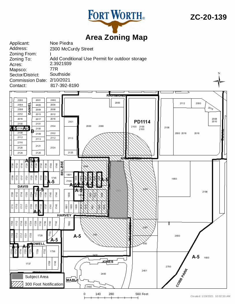
Area Zoning Map
ZC-20-139
Applicant: Address:Zoning From:Zoning To:Acres:Mapsco:Sector/District:Commission Date:Contact:
Noe Piedra
77R2.3921939Add Conditional Use Permit for outdoor storageI2300 McCurdy Street
817-392-81902/10/2021Southside
Created: 1/19/2021 10:02:53 AM
Subject Area300 Foot Notification
Ü

0 2,000 4,0001,000 Feet
Area Map
ZC-20-139
Created: 1/19/2021 10:03:01 AMÜ
CONSERVATION DISTRICT
Overlay DistrictsAirport Overlay DistrictI-35WTU PERIPHERALDESIGN DISTRICT
Noise ContoursDECIBEL
6570758085
Council Districts
4 - Cary M oon5 - Gyna B ivens6 - Jungus Jordan7 - Dennis Shingleton8 - Kelly Allen Gray9 - Ann Zadeh
3 - B rian Byrd2 - Carlos E. Flo res
280 0 280140 FeetA Com prehens iv e P lan shall not c ons titu te z oning r egulations ores tab l is h z oning d istrict boundaries . (Texas Loc al Governm ent Code, S ection 213.005.) Land use des ignations were approv ed by City Counci l on M arc h 6, 2018.
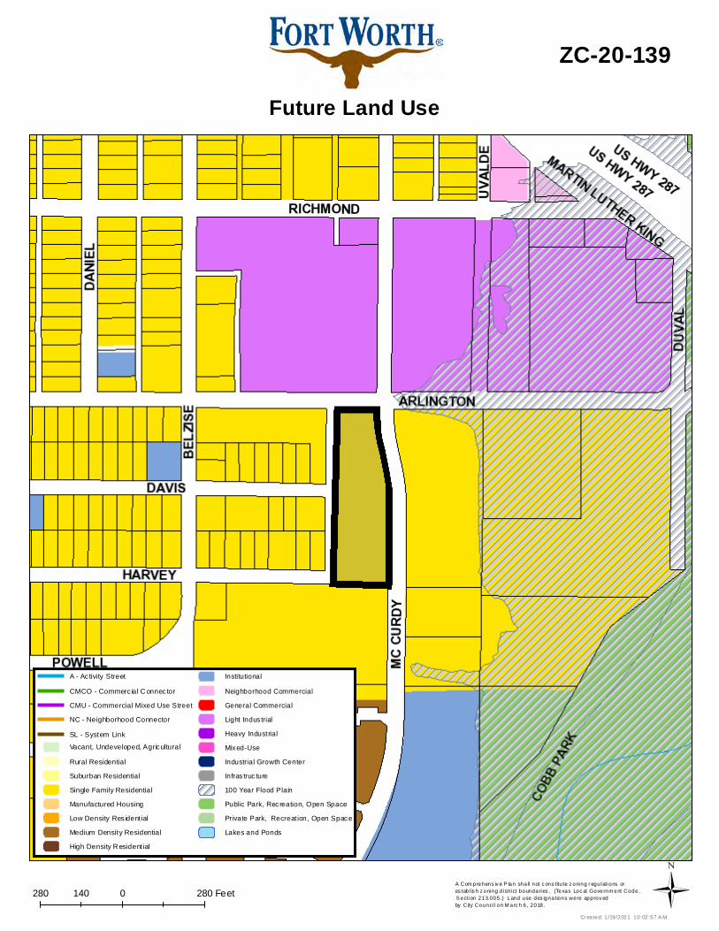
Future Land Use
ZC-20-139
Cr eated: 1 /19/2021 10:02:57 A MÜ
Vacant, Undeveloped, AgriculturalRural ResidentialSuburban ResidentialSingle Family ResidentialManufactured HousingLow Density Res ident ialMedium Density ResidentialHigh Density R esident ial
InstitutionalNeighborhood CommercialGeneral CommercialLight Indus trialHeavy IndustrialMixed-UseIndustrial Growth CenterInfras truc ture100 Year Flood PlainPublic Park, Recreation, Open SpacePrivate Park, Recreat ion, Open SpaceLakes and Ponds
CMU - Commercial Mixed Use StreetNC - Neighborhood Connector
A - Ac tivity StreetCMCO - Commerc ial C onnec tor
SL - System Link

0 360 720180 Feet
Aerial Photo Map
ZC-20-139
Ü
Page 1 of 2
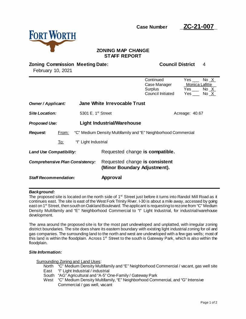
Case Number _ZC-21-007_
ZONING MAP CHANGE STAFF REPORT
Zoning Commission Meeting Date: Council District 4 February 10, 2021
Continued Yes ___ No _X_ Case Manager _Monica Lafitte__ Surplus Yes ___ No _X_ Council Initiated Yes ___ No _X_
Owner / Applicant: Jane White Irrevocable Trust Site Location: 5301 E. 1st Street Acreage: 40.67 Proposed Use: Light Industrial/Warehouse Request: From: “C” Medium Density Multifamily and “E” Neighborhood Commercial
To: “I” Light Industrial
Land Use Compatibility: Requested change is compatible. Comprehensive Plan Consistency: Requested change is consistent
(Minor Boundary Adjustment).
Staff Recommendation: Approval
Background: The proposed site is located on the north side of 1st Street just before it turns into Randol Mill Road as it continues east. The site is east of the West Fork Trinity River. I-30 is about a mile away, accessed by going east on 1st Street, then south on Oakland Boulevard. The applicant is requesting to rezone from “C” Medium Density Multifamily and “E” Neighborhood Commercial to “I” Light Industrial, for industrial/warehouse development. The area around the proposed site is for the most part undeveloped and unplatted, with irregular zoning district boundaries. The site does share its eastern boundary with existing light industrial zoning for oil and gas companies. The surrounding land to the north and west are undeveloped with a few gas wells; most of this land is within the floodplain. Across 1st Street to the south is Gateway Park, which is also within the floodplain. Site Information:
Surrounding Zoning and Land Uses:
North “C” Medium Density Multifamily and “E” Neighborhood Commercial / vacant, gas well site East “I” Light Industrial / industrial South “AG” Agricultural and “A-5” One-Family / Gateway Park West “C” Medium Density Multifamily, “E” Neighborhood Commercial, and “G” Intensive
Commercial / gas well, vacant

Page 2 of 2
Zoning History: ZC-16-096; AG, C, D-HR1, E, G to O-1, PD/E, PD/SU for concrete recycling facility; subject site and surrounding area to the east and north; Denied
Public Notification:
300 foot Legal Notifications were mailed on January 21, 2021. The following organizations were notified: (emailed January 19, 2021)
Organizations Notified Riverside Alliance Neighborhoods of East Fort Worth Garden of Eden NA White Lake Hills NA Nolan Catholic High School East Fort Worth, Inc. Streams and Valleys Inc. Trinity Habitat for Humanity East Fort Worth Business Association Birdville ISD Fort Worth ISD
Site not located within a registered Neighborhood Association Development Impact Analysis:
1. Land Use Compatibility The applicant is requesting to rezone from “C” Medium Density Multifamily and “E” Neighborhood Commercial to “I” Light Industrial for industrial warehouse use. East of the site is existing “I” Light Industrial, occupied by oil and gas companies. Additionally, multiple gas well pads surround the site. The northern portion of the site is bordered by power lines. Most of the surrounding area to the north and west are vacant and are located in the floodplain. Gateway Park to the south is also within the floodplain. As it is very unlikely the surrounding areas will be developed due to the floodplain, and the existing industrial development adjacent to the east, the proposed "I" Light Industrial zoning is compatible at this location.
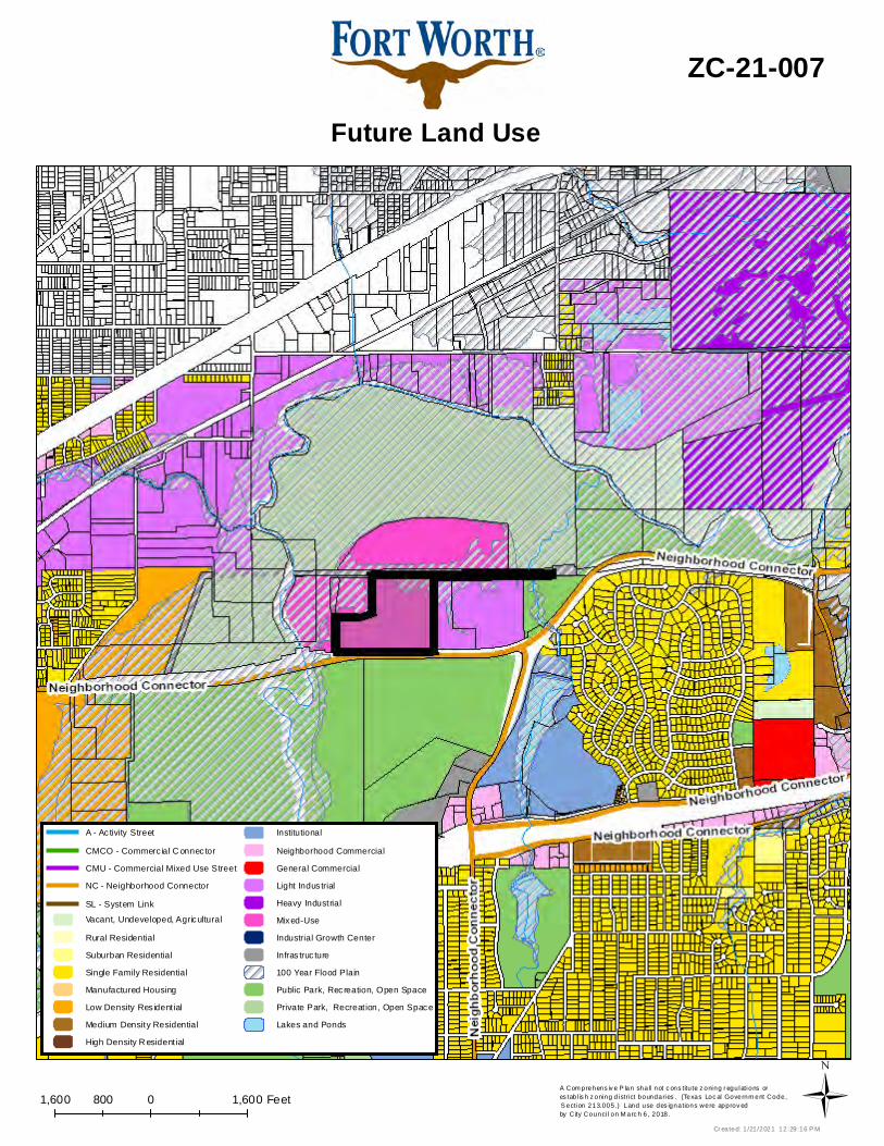
2. Comprehensive Plan Consistency-Eastside
The 2020 Comprehensive Plan designates the subject property as Mixed-Use. While the proposed zoning does not follow the intended Future Land Use, the “I” Light Industrial zoning and warehouse use, with the site’s direct and clear access to I-30 and Highway 121, are supported by the following policies of the Comprehensive Plan: • Promote appropriate infill development of vacant lots within developed areas, which will
efficiently utilize existing infrastructure • Locate large industrial uses along freight lines, highways, or airports within industrial growth
centers and other appropriate locations. Based on conformance with the policies stated above, the proposed zoning is consistent with the Comprehensive Plan (minor boundary adjustment). Staff recommends designating the area as Light Industrial Future Land Use, especially if the requested zoning change is approved.
3. Economic Development Strategic Plan The 2018 Economic Development Strategic Plan identified a vision, goals, and strategies in order to facilitate the success and growth of the City of Fort Worth. The Plan includes performance metrics that place an emphasis on outcomes that create: • High-wage job growth. • A more sustainable tax base, driven less by residential property valuation and more by
commercial and industrial investment. Attachments:
• Area Zoning Map with 300 ft. Notification Area
• Area Map • Future Land Use Map • Aerial Photograph

0 975 1,950487.5 Feet
Area Zoning Map
ZC-21-007
Applicant: Address:Zoning From:Zoning To:Acres:Mapsco:Sector/District:Commission Date:Contact:
Jane White Irrevocable Trust
64V40.68771882IC, E, G5301 & 5317 E. First Street
817-392-28062/10/2021Eastside
Created: 1/21/2021 12:29:18 PM
Subject Area300 Foot Notification
Ü
0 2,000 4,0001,000 Feet
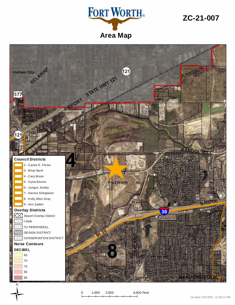
Area Map
ZC-21-007
Created: 1/21/2021 12:29:11 PMÜ
CONSERVATION DISTRICT
Overlay DistrictsAirport Overlay DistrictI-35WTU PERIPHERALDESIGN DISTRICT
Noise ContoursDECIBEL
6570758085
Council Districts
4 - Cary M oon5 - Gyna B ivens6 - Jungus Jordan7 - Dennis Shingleton8 - Kelly Allen Gray9 - Ann Zadeh
3 - B rian Byrd2 - Carlos E. Flo res
1,600 0 1,600800 FeetA Com prehens iv e P lan shall not c ons titu te z oning r egulations ores tab l is h z oning d istrict boundaries . (Texas Loc al Governm ent Code, S ection 213.005.) Land use des ignations were approv ed by City Counci l on M arc h 6, 2018.
Future Land Use
ZC-21-007
Cr eated: 1 /21/2021 12:29:16 P MÜ
Vacant, Undeveloped, AgriculturalRural ResidentialSuburban ResidentialSingle Family ResidentialManufactured HousingLow Density Res ident ialMedium Density ResidentialHigh Density R esident ial
InstitutionalNeighborhood CommercialGeneral CommercialLight Indus trialHeavy IndustrialMixed-UseIndustrial Growth CenterInfras truc ture100 Year Flood PlainPublic Park, Recreation, Open SpacePrivate Park, Recreat ion, Open SpaceLakes and Ponds
CMU - Commercial Mixed Use StreetNC - Neighborhood Connector
A - Ac tivity StreetCMCO - Commerc ial C onnec tor
SL - System Link

0 2,100 4,2001,050 Feet
Aerial Photo Map
ZC-21-007
Ü
Page 1 of 2
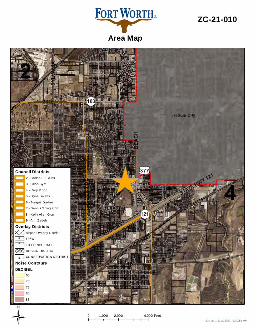
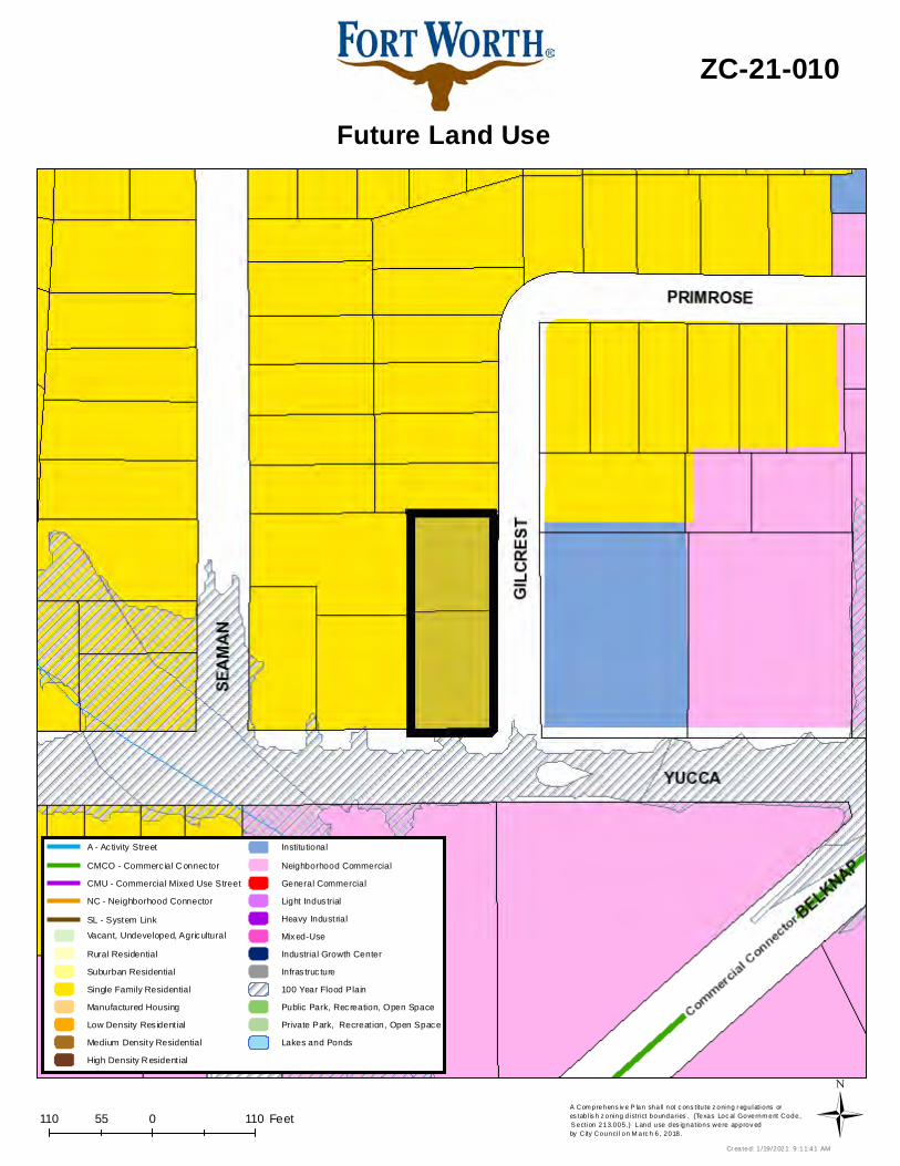
Case Number _ZC-21-010_
ZONING MAP CHANGE STAFF REPORT
Zoning Commission Meeting Date: Council District 4 February 10, 2021
Continued Yes __ No _X_ Case Manager _Monica Lafitte _ Surplus Yes ___ No _X_ Council Initiated Yes ___ No _X_
Owner / Applicant: Guadalupe Valerio Site Location: 3805 Yucca Avenue & 1307 Gilcrest Drive Acreage: 0.44 Proposed Use: Retail and Ice Cream Shop Request: From: “A-7.5” One Family
To: “E” Neighborhood Commercial
Land Use Compatibility: Requested change is compatible. Comprehensive Plan Consistency: Requested change is consistent (Minor Boundary
Adjustment). Staff Recommendation: Approval Background: The proposed site consists of two lots located at the northwest corner of Yucca Avenue and Gilcrest Street, about 500 feet west of the intersection of Beach Street and Belknap Street. The corner lot is addressed off of Yucca Avenue and is currently used as a parking lot; the internal lot is addressed off of Gilcrest Drive and is currently vacant. The site is located within a Neighborhood Empowerment Zone, NEZ Area Four. The applicant submitted a NEZ application, NZ20-01072, which was approved in November. The applicant is requesting to change the zoning from “A-7.5” One Family to “E” Neighborhood Commercial in order to build retail and an ice cream shop. Surrounding land uses include residential directly adjacent to the north and west, commercial across the street to the south, and community facilities across the street to the east. Site Information:
Surrounding Zoning and Land Uses: North “A-5” One Family / residential East “CF” Community Facilities / Knight of Columbus hall South “E” Neighborhood Commercial / commercial (Sammies Bar-B-Q, Walgreens) West “A-7.5” One Family / residential
Zoning History: None
Page 2 of 2
Public Notification: 300 foot Legal Notifications were mailed on January 21, 2021.
The following organizations were notified: (emailed January 19, 2021) Organizations Notified
Riverside Alliance Carter Riverside NA* East Fort Worth, Inc. Streams And Valleys Inc Trinity Habitat for Humanity Oakhurst Alliance of Neighbors East Fort Worth Business Association Birdville ISD Fort Worth ISD
*Located within this Neighborhood Association Development Impact Analysis:
1. Land Use Compatibility The applicant is proposing to change the zoning to “E” Neighborhood Commercial for retail and ice cream shop use. Surrounding land uses are residential directly adjacent to the north and west and commercial/community facilities across the street to the south and east, respectively. The two lots requesting the rezone are the same depth as the “CF” Community Facilities zone across Gilcrest Street, which then has “E” Neighborhood Commercial further to the west with a similar lot depth. The “CF” and “E” districts stretch from the subject lot going west to the Belknap and Beach intersection. Across Yucca Avenue, the “E” district stretches from the Belknap and Beach intersection to the street to the east of the subject site, Seaman Street. In other words, across Yucca Avenue, the “E” district spans the length of the block face on either side of the subject site. Due to the site’s location on the corner of the intersection, it actually interacts more with the non-residential uses across Gilcrest Street and Yucca Avenue than it will with the residential lots to the north that face Gilcrest or the two residential lots to the west that face Yucca Avenue. One of the lots appears to have already been serving in some sort of commercial capacity, as it is a parking lot. Therefore, the proposed use is compatible with surrounding uses.
2. Comprehensive Plan Consistency – Northeast
The 2020 Comprehensive Plan designates the subject property as Single-Family Residential. The proposed use does not meet the below policy within the Comprehensive Plan:
• Protect neighborhoods from commercial and industrial encroachment from Belknap Street, 28th Street, Sylvania Avenue and Riverside Drive. However, it does meet the below policies within the Comprehensive Plan:
• Promote appropriate infill development of vacant lots within developed areas, which will efficiently utilize existing infrastructure
• Encourage the revitalization of commercial districts with neighborhood-oriented retail, services, and office space.
• Stimulate the redevelopment of the East Belknap Street, Sylvania Avenue, and NE 28th Street commercial districts.
Based on conformance with the policies stated above outweighing the lack of conformance, the proposed zoning is consistent (Minor Boundary Adjustment) with the Comprehensive Plan.
Attachments:
• Area Zoning Map with 300 ft. Notification Area • Area Map • Future Land Use Map • Aerial Photograph

0 200 400100 Feet
Area Zoning Map
ZC-21-010
Applicant: Address:Zoning From:Zoning To:Acres:Mapsco:Sector/District:Commission Date:Contact:
Guadalupe Valerio
64J0.47654593EA-53805 Yucca Avenue, 1307 Gilcrest Drive
817-392-28062/10/2021Northeast
Created: 1/19/2021 9:11:16 AM
Subject Area300 Foot Notification
Ü
0 2,000 4,0001,000 Feet
Area Map
ZC-21-010
Created: 1/19/2021 9:10:51 AMÜ
CONSERVATION DISTRICT
Overlay DistrictsAirport Overlay DistrictI-35WTU PERIPHERALDESIGN DISTRICT
Noise ContoursDECIBEL
6570758085
Council Districts
4 - Cary M oon5 - Gyna B ivens6 - Jungus Jordan7 - Dennis Shingleton8 - Kelly Allen Gray9 - Ann Zadeh
3 - B rian Byrd2 - Carlos E. Flo res
110 0 11055 FeetA Com prehens iv e P lan shall not c ons titu te z oning r egulations ores tab l is h z oning d istrict boundaries . (Texas Loc al Governm ent Code, S ection 213.005.) Land use des ignations were approv ed by City Counci l on M arc h 6, 2018.
Future Land Use
ZC-21-010
Cr eated: 1 /19/2021 9 :11:41 AMÜ
Vacant, Undeveloped, AgriculturalRural ResidentialSuburban ResidentialSingle Family ResidentialManufactured HousingLow Density Res ident ialMedium Density ResidentialHigh Density R esident ial
InstitutionalNeighborhood CommercialGeneral CommercialLight Indus trialHeavy IndustrialMixed-UseIndustrial Growth CenterInfras truc ture100 Year Flood PlainPublic Park, Recreation, Open SpacePrivate Park, Recreat ion, Open SpaceLakes and Ponds
CMU - Commercial Mixed Use StreetNC - Neighborhood Connector
A - Ac tivity StreetCMCO - Commerc ial C onnec tor
SL - System Link
0 140 28070 Feet
Aerial Photo Map
ZC-21-010
Ü
Page 1 of 2
Case Number _SP-21-002_
ZONING MAP CHANGE STAFF REPORT
Zoning Commission Meeting Date: Council District 6 February 10, 2021
Continued Yes __ No _X_ Case Manager _Laura Evans _ Surplus Yes ___ No _X_ Council Initiated Yes ___ No _X_
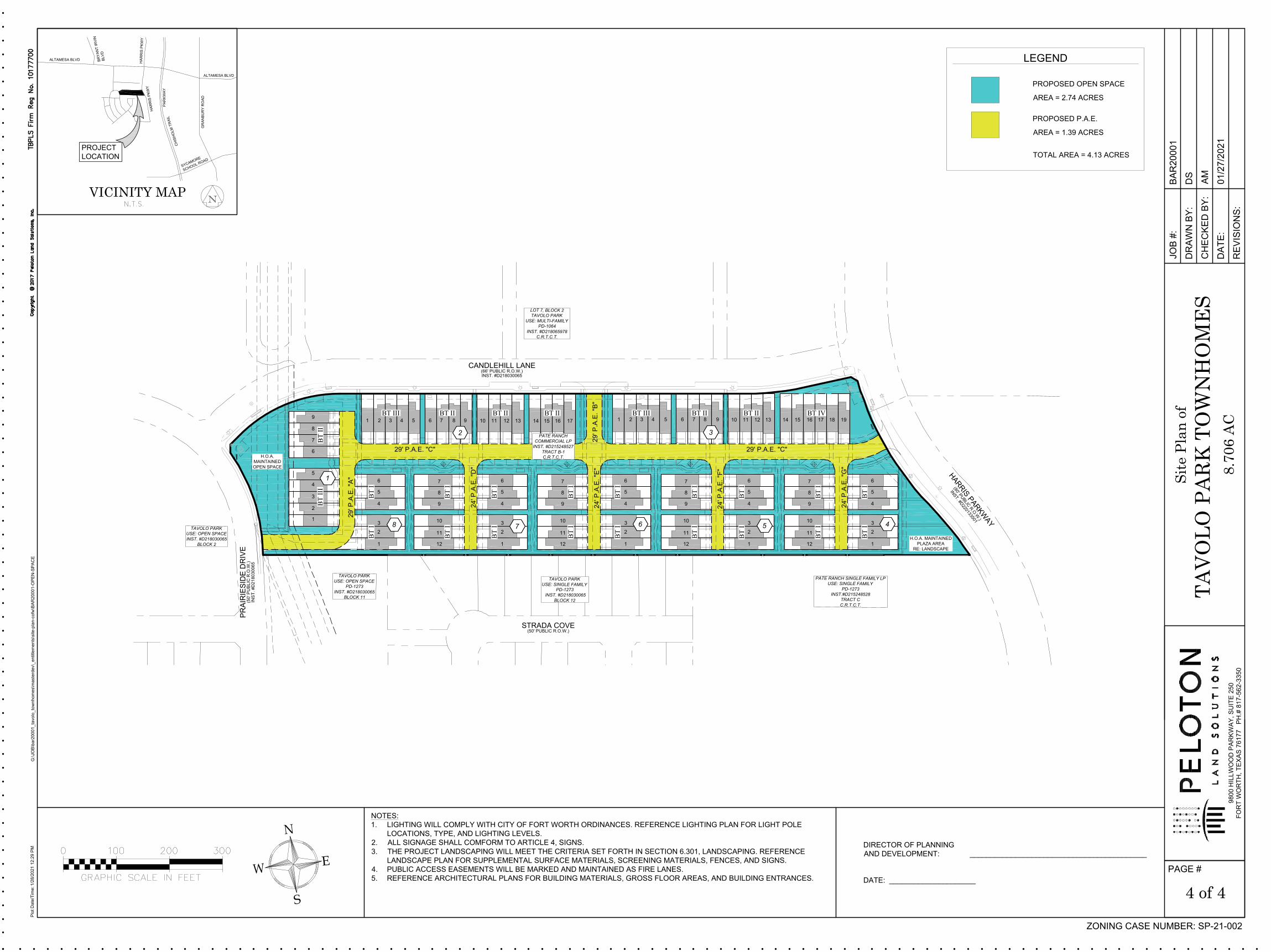
Owner / Applicant: Pate Ranch Commercial LP Site Location: 7400 block Prairieside Drive Acreage: 8.7 Proposed Use: Required site plan for PD 1064 Companion Cases: ZC-14-147/PD-1064 Staff Recommendation: Approval Background: The proposed site is located at the southeast corner of Prairieside Drive and Candlehill Lane. The applicant is providing the required site plan for PD 1064. The PD zoning was approved in 2014 for PD/MU-2 excluding multiple uses. The proposed site plan includes 99 units varying in size and height that meet the MU-2 requirements. The area on the far west side of the project is encumbered by several easements, which prohibits the buildings to have direct frontage onto Prairieside Drive. The applicant has indicated this area will be an HOA X Lot, intended as open space. The area on the far east side of the project is not encumbered by easements, but it does have a sharp angle due to the location of the street. The applicant has indicated this area will be programmed like a plaza with amenities that the residents and public can enjoy. The applicant has provided an exhibit that illustrates the open spaces within the project. Site Information:
Surrounding Zoning and Land Uses: North PD 1064 / multifamily East PD 1064 / undeveloped South PD 1273 / single family West PD 1273/1064 / detention pond
Zoning History: ZC-20-010 SP-16-015
Site Plan Comments: The site plan as submitted is in general compliance with the Zoning Ordinance regulations.
(Comments made by Platting (Subdivision Ordinance), Transportation/Public Works, Fire, Park & Recreation, and Water Department staff cannot be waived through the Zoning Commission
Page 2 of 2
and City Council. Approval of the zoning site plan does not constitute the acceptance of conditions.)
Public Notification:
300 foot Legal Notifications were mailed on January 22, 2021. The following organizations were notified: (emailed January 19, 2021)
Organizations Notified Briercliff Estates HA Quail Ridge Estates Phase II HOA Park Palisades HA Quail Ridge Estates HOA District 6 Alliance Streams And Valleys Inc Trinity Habitat for Humanity Crowley ISD
*Located within this Neighborhood Association Attachments:
• Area Zoning Map with 300 ft. Notification Area • Site Plan • Landscaping Exhibit • Area Map • Future Land Use Map • Aerial Photograph
0 475 950237.5 Feet
Area Zoning Map
SP-21-002
Applicant: Address:Zoning From:Zoning To:Acres:Mapsco:Sector/District:Commission Date:Contact:
Pate Ranch Commercial LP
102G8.70639411Required site plan for townhousesPD 10647400 block Prairieside Drive
817-392-80432/10/2021Far Southwest
Created: 1/19/2021 9:11:22 AM
Subject Area300 Foot Notification
Ü

S
S
S
S
CANDLEHILL LANE
(66' PUBLIC R.O.W.)
INST. #D218030065
H
A
R
R
I
S
P
A
R
K
W
A
Y
(
8
0
'
P
U
B
L
I
C
R
.
O
.
W
.
)
I
N
S
T
.
#
D
2
2
0
1
3
3
5
0
1
PR
AIR
IE
SID
E D
RIV
E
(5
0' P
UB
LIC
R
.O
.W
.)
IN
ST
. #
D2
18
03
00
65
29
' P
.A
.E
. "B
"
24
' P
.A
.E
. "D
"
24
' P
.A
.E
. "E
"
24
' P
.A
.E
. "F
"
24
' P
.A
.E
. "G
"
29' P.A.E. "C"
29
' P
.A
.E
. "A
"
29' P.A.E. "C"
20' EX. PIPELINE
EASEMENT
20' EX. PIPELINE
EASEMENT
20' EX. SEWERLINE
EASEMENT
TAVOLO PARK
USE: OPEN SPACE
INST. #D218030065
BLOCK 2
LOT 7, BLOCK 2
TAVOLO PARK
USE: MULTI-FAMILY
PD-1064
INST. #D218065978
C.R.T.C.T.
TAVOLO PARK
USE: SINGLE FAMILY
PD-1273
INST. #D218030065
BLOCK 12
PATE RANCH SINGLE FAMILY LP
USE: SINGLE FAMILY
PD-1273
INST.#D215248528
TRACT C
C.R.T.C.T.
TAVOLO PARK
USE: OPEN SPACE
PD-1273
INST. #D218030065
BLOCK 11
PROP. MONUMENT SIGN
PROP. MONUMENT
SIGN
EX. FENCE
TO REMAIN
6 - EX. ON-STREET
PARKING STALLS
13 - EX. ON-STREET
PARKING STALLS
8 - EX. ON-STREET
PARKING STALLS
7 - EX. ON-STREET
PARKING STALLS
REMAIN AFTER
LOSING 6 STALLS
10
' E
X. U
TIL
IT
Y
EA
SE
ME
NT
EX. ELECTRIC
EASMENT
2
0
'
E
X
.
L
A
N
D
S
C
A
P
E
E
A
S
E
M
E
N
T
EX. ELECTRIC
EASMENT
5
'
E
X
.
S
E
W
E
R
L
I
N
E
E
A
S
E
M
E
N
T
10' EX
. UTIL
ITY
EA
SE
ME
NT
STRADA COVE
(50' PUBLIC R.O.W.)
5
5
55
BT IIBT III BT IIBT II BT III BT II BT II BT IV
BT
I
BT
I
BT
I
BT
I
BT
I
BT
I
BT
I
BT
I
BT
I
BT
I
BT
I
BT
I
BT
I
BT
I
BT
I
BT
I
BT
I
BT
I
BT
III
BT
II
PATE RANCH
COMMERCIAL LP
INST. #D215248527
TRACT B-1
C.R.T.C.T.
H.O.A. MAINTAINED
PLAZA AREA
RE: LANDSCAPE
H.O.A.
MAINTAINED
OPEN SPACE
20
' M
AX
BU
IL
DIN
G
SE
TB
AC
K
2
0
'
M
A
X
B
U
I
L
D
I
N
G
S
E
T
B
A
C
K
2
0
'
M
A
X
B
U
I
L
D
I
N
G
S
E
T
B
A
C
K
5' B
UIL
DIN
G
SE
TB
AC
K
1 2 3 4 5 6 7 8 9 10 11 12 13 14 15 17
1 2 3 4 5 6 7 8 910 11 12 13 14 15 16 17 18
12
11
10
9
8
7
6
5
4
3
2
1
1
2
3
4
5
6
7
8
9
12
11
10
9
8
7
6
5
4
3
2
1
16
12
11
10
9
8
7
6
5
4
3
2
1 12
11
10
9
8
7
6
5
4
3
2
1
6
5
4
3
2
1
19
1
23
4
67
8
5
NOTES:
1. LIGHTING WILL COMPLY WITH CITY OF FORT WORTH ORDINANCES. REFERENCE LIGHTING PLAN FOR LIGHT POLE
LOCATIONS, TYPE, AND LIGHTING LEVELS.
2. ALL SIGNAGE SHALL COMFORM TO ARTICLE 4, SIGNS.
3. THE PROJECT LANDSCAPING WILL MEET THE CRITERIA SET FORTH IN SECTION 6.301, LANDSCAPING. REFERENCE
LANDSCAPE PLAN FOR SUPPLEMENTAL SURFACE MATERIALS, SCREENING MATERIALS, FENCES, AND SIGNS.
4. PUBLIC ACCESS EASEMENTS WILL BE MARKED AND MAINTAINED AS FIRE LANES.
5. REFERENCE ARCHITECTURAL PLANS FOR BUILDING MATERIALS, GROSS FLOOR AREAS, AND BUILDING ENTRANCES.
DIRECTOR OF PLANNING
AND DEVELOPMENT: ___________________________________________
DATE: _____________________
PAGE #
9800 H
ILLW
OO
D P
AR
KW
AY
, S
UIT
E 25
0
FO
RT
W
OR
TH
, T
EX
AS
7
617
7 P
H.#
8
17
-562
-335
0
Site
Pla
n of
JO
B #
:
DR
AW
N B
Y:
CH
EC
KE
D B
Y:
DA
TE
:
RE
VIS
IO
NS
:
N
E
S
W
VICINITY MAP
ZONING CASE NUMBER: SP-21-002
TAV
OLO
PA
RK
TO
WN
HO
ME
S8.
706
AC
1 of 4
BA
R2
00
01
DS
AM
01
/2
7/2
02
1
Plo
t D
ate
/T
im
e: 1
/2
8/2
02
1 1
2:2
7 P
M
G:\JO
B\b
ar2
00
01
_ta
vo
lo
_to
wn
ho
me
s\m
aste
rd
ev\_
en
title
me
nts\site
-p
la
n-co
fw
\B
AR
20
00
1-S
IT
E-P
LA
N
PROPOSED EASEMENT LEGEND:
P.A.E. = PUBLIC ACCESS EASEMENT
SITE SUMMARY
REQUIREMENTS MINIMUM PROVIDED
FRONT YARD SETBACK
0' MIN / 20' MAX 15' - 27'
REAR YARD SETBACK
5' MIN 20' - 23'
SIDE STREET SETBACK
0' MIN / 20' MAX VARIES
OPEN SPACE
NONE ±2.74 AC
RESIDENT PARKING
2 PER UNIT 198
GUEST PARKING
NONE 20
TOTAL PARKING
198 218
ALTAMESA BLVD
ALTAMESA BLVD
S
Y
C
A
M
O
R
E
S
C
H
O
O
L
R
O
A
D
C
H
IS
H
O
L
M
T
R
A
IL
PA
RK
WA
Y
H
A
R
R
IS
P
K
W
Y
B
R
Y
A
N
T
IR
V
IN
B
L
V
D
HA
RR
IS
P
KW
Y
GR
AN
BU
RY
R
OA
D
PROJECT
LOCATION
BUILDING SUMMARY
BUILDING TYPE UNITS PER BLDG # OF BLDGS
BUILDING HEIGHT
(STORIES/FT)
FLOOR AREA
PER BLDG (SF)
I3 18 2 / 33'-11"
6,314
II4 6 2 / 33'-11"
8,419
III5 2 2 / 33'-11"
10,524
IV6 2 2 / 33'-11"
12,629
GROSS FLOOR AREA (SF)210,472
DENSITY (UNITS/AC)
11.37
LEGEND
PROPOSED ON-STREET
PARKING COUNT
PROPOSED VEHICULAR
CONCRETE PAVEMENT
PROPOSED CONCRETE
SIDEWALK
DIRECTION OF TRAFFIC
5
PROPERTY BOUNDARY
LOT LINES
EASEMENT
PROPOSED STREET LIGHTS
SITE KEY MAP
PAGE #2
PAGE #3
TYPICAL LOT LAYOUT
22'
TYP
95
'
TYPICAL
BUILDING
15
'
MIN
FRONT OF UNITS
REAR OF
UNITS
27
'
MA
X4
5' M
IN
23
' M
AX
60
' M
AX
20
' M
IN
P.A.E. (TYP)
PUBLIC STREET
OR MEWS
S
S
S
S
CANDLEHILL LANE
(66' PUBLIC R.O.W.)
INST. #D218030065
H
A
R
R
I
S
P
A
R
K
W
A
Y
(
8
0
'
P
U
B
L
I
C
R
.
O
.
W
.
)
I
N
S
T
.
#
D
2
2
0
1
3
3
5
0
1
PR
AIR
IE
SID
E D
RIV
E
(50' P
UB
LIC
R
.O
.W
.)
IN
ST
. #D
218030065
29
' P
.A
.E
. "B
"
24
' P
.A
.E
. "D
"
24
' P
.A
.E
. "E
"
24
' P
.A
.E
. "F
"
24
' P
.A
.E
. "G
"
29' P.A.E. "C"
29
' P
.A
.E
. "A
"
29' P.A.E. "C"
TAVOLO PARK
USE: OPEN SPACE
INST. #D218030065
BLOCK 2
LOT 7, BLOCK 2
TAVOLO PARK
USE: MULTI-FAMILY
PD-1064
INST. #D218065978
C.R.T.C.T.
TAVOLO PARK
USE: SINGLE FAMILY
PD-1273
INST. #D218030065
BLOCK 12
PATE RANCH SINGLE FAMILY LP
USE: SINGLE FAMILY
PD-1273
INST.#D215248528
TRACT C
C.R.T.C.T.
TAVOLO PARK
USE: OPEN SPACE
PD-1273
INST. #D218030065
BLOCK 11
STRADA COVE
(50' PUBLIC R.O.W.)
BT IIBT III BT IIBT II BT III BT II BT II BT IV
BT
I
BT
I
BT
I
BT
I
BT
I
BT
I
BT
I
BT
I
BT
I
BT
I
BT
I
BT
I
BT
I
BT
I
BT
I
BT
I
BT
I
BT
I
BT
III
BT
II
PATE RANCH
COMMERCIAL LP
INST. #D215248527
TRACT B-1
C.R.T.C.T.
H.O.A. MAINTAINED
PLAZA AREA
RE: LANDSCAPE
H.O.A.
MAINTAINED
OPEN SPACE
1 2 3 4 5 6 7 8 910 11 12 13
14 15 17
1 2 3 4 5 6 7 8 910 11 12 13 14 15 16 17 18
12
11
10
9
8
7
6
5
4
3
2
1
1
2
3
4
5
6
7
8
9
12
11
10
9
8
7
6
5
4
3
2
1
16
12
11
10
9
8
7
6
5
4
3
2
1 12
11
10
9
8
7
6
5
4
3
2
1
6
5
4
3
2
1
19
1
23
46
7
8
5
NOTES:
1. LIGHTING WILL COMPLY WITH CITY OF FORT WORTH ORDINANCES. REFERENCE LIGHTING PLAN FOR LIGHT POLE
LOCATIONS, TYPE, AND LIGHTING LEVELS.
2. ALL SIGNAGE SHALL COMFORM TO ARTICLE 4, SIGNS.
3. THE PROJECT LANDSCAPING WILL MEET THE CRITERIA SET FORTH IN SECTION 6.301, LANDSCAPING. REFERENCE
LANDSCAPE PLAN FOR SUPPLEMENTAL SURFACE MATERIALS, SCREENING MATERIALS, FENCES, AND SIGNS.
4. PUBLIC ACCESS EASEMENTS WILL BE MARKED AND MAINTAINED AS FIRE LANES.
5. REFERENCE ARCHITECTURAL PLANS FOR BUILDING MATERIALS, GROSS FLOOR AREAS, AND BUILDING ENTRANCES.
DIRECTOR OF PLANNING
AND DEVELOPMENT: ___________________________________________
DATE: _____________________
PAGE #
9800 H
ILLW
OO
D P
AR
KW
AY
, S
UIT
E 25
0
FO
RT
W
OR
TH
, T
EX
AS
7
617
7 P
H.#
8
17
-562
-335
0
Site
Pla
n of
JO
B #
:
DR
AW
N B
Y:
CH
EC
KE
D B
Y:
DA
TE
:
RE
VIS
IO
NS
:
N
E
S
W
VICINITY MAP
ZONING CASE NUMBER: SP-21-002
TAV
OLO
PA
RK
TO
WN
HO
ME
S8.
706
AC
4 of 4
BA
R2
00
01
DS
AM
01
/2
7/2
02
1
Plo
t D
ate
/T
im
e: 1
/2
8/2
02
1 1
2:2
9 P
M
G:\JO
B\b
ar2
00
01
_ta
vo
lo
_to
wn
ho
me
s\m
aste
rd
ev\_
en
title
me
nts\site
-p
la
n-co
fw
\B
AR
20
00
1-O
PE
N-S
PA
CE
ALTAMESA BLVD
ALTAMESA BLVD
S
Y
C
A
M
O
R
E
S
C
H
O
O
L
R
O
A
D
C
H
IS
H
O
L
M
T
R
A
IL
PA
RK
WA
Y
H
A
R
R
IS
P
K
W
Y
B
R
Y
A
N
T
IR
V
IN
B
L
V
D
HA
RR
IS
P
KW
Y
GR
AN
BU
RY
R
OA
D
PROJECT
LOCATION
LEGEND
PROPOSED OPEN SPACE
AREA = 2.74 ACRES
PROPOSED P.A.E.
AREA = 1.39 ACRES
TOTAL AREA = 4.13 ACRES

0 2,000 4,0001,000 Feet
Area Map
SP-21-002
Created: 1/19/2021 9:10:47 AMÜ
CONSERVATION DISTRICT
Overlay DistrictsAirport Overlay DistrictI-35WTU PERIPHERALDESIGN DISTRICT
Noise ContoursDECIBEL
6570758085
Council Districts
4 - Cary M oon5 - Gyna B ivens6 - Jungus Jordan7 - Dennis Shingleton8 - Kelly Allen Gray9 - Ann Zadeh
3 - B rian Byrd2 - Carlos E. Flo res

660 0 660330 FeetA Com prehens iv e P lan shall not c ons titu te z oning r egulations ores tab l is h z oning d istrict boundaries . (Texas Loc al Governm ent Code, S ection 213.005.) Land use des ignations were approv ed by City Counci l on M arc h 6, 2018.
Future Land Use
SP-21-002
Cr eated: 1 /19/2021 9 :11:42 AMÜ
Vacant, Undeveloped, AgriculturalRural ResidentialSuburban ResidentialSingle Family ResidentialManufactured HousingLow Density Res ident ialMedium Density ResidentialHigh Density R esident ial
InstitutionalNeighborhood CommercialGeneral CommercialLight Indus trialHeavy IndustrialMixed-UseIndustrial Growth CenterInfras truc ture100 Year Flood PlainPublic Park, Recreation, Open SpacePrivate Park, Recreat ion, Open SpaceLakes and Ponds
CMU - Commercial Mixed Use StreetNC - Neighborhood Connector
A - Ac tivity StreetCMCO - Commerc ial C onnec tor
SL - System Link
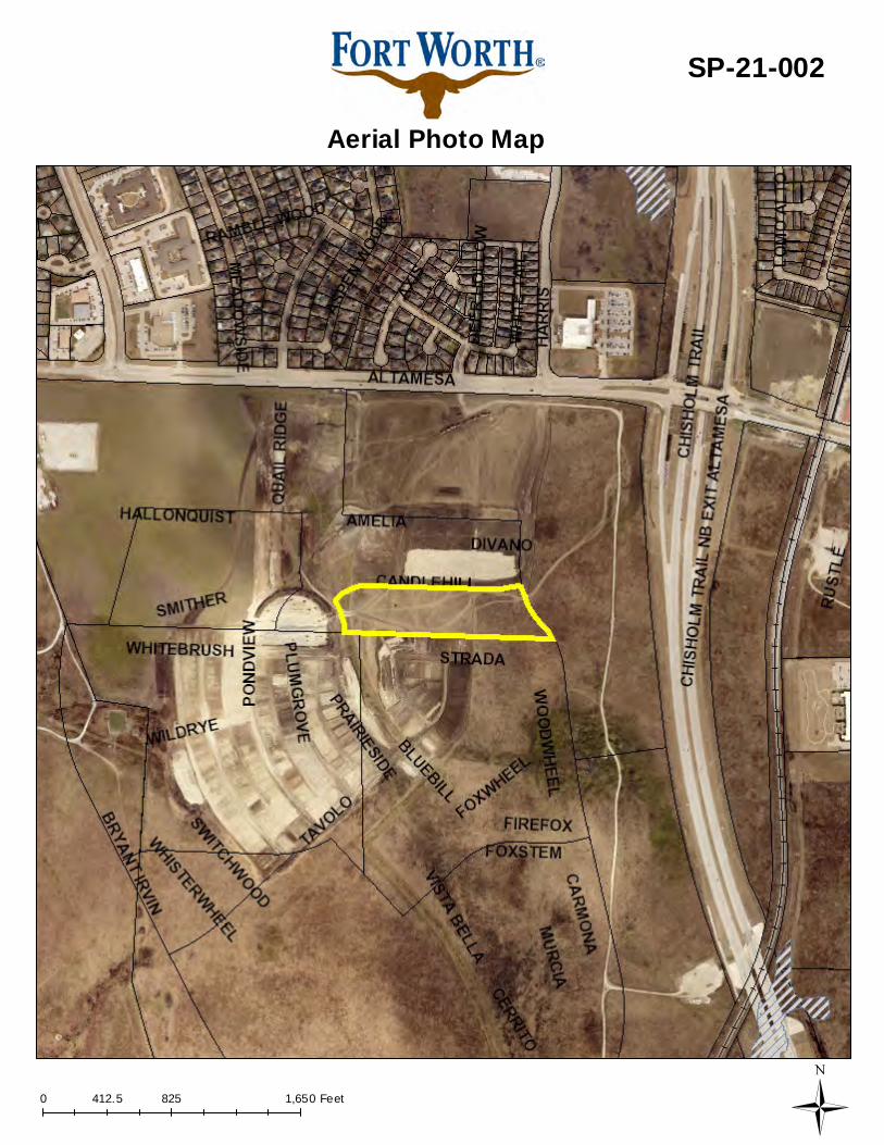
0 825 1,650412.5 Feet
Aerial Photo Map
SP-21-002
Ü
Page 1 of 3
Case Number _ZC-21-011
ZONING MAP CHANGE STAFF REPORT
Zoning Commission Meeting Date: Council District 5 February 10, 2021
Continued Yes __ No _X_ Case Manager _Monica Lafitte _ Surplus Yes ___ No _X_ Council Initiated Yes ___ No _X_
Owner / Applicant: Carey Street Holdings LLC Site Location: 4301 Carey Street Acreage: 3.00 acre Proposed Use: Outdoor non-accessory storage Request: From: “I” Light Industrial
To: Add Conditional Use Permit (CUP) for outdoor storage, maximum of 5 years; site plan included
Land Use Compatibility: Requested change is compatible. Comprehensive Plan Consistency: Requested change is consistent. Staff Recommendation: Approval Background: The subject property is located off of Carey Street, four lots north of Wilbarger Street. More generally, it is near Lake Arlington, north of where Highway 287 meets East Loop 820; the site has direct and clear access to both highways. The subject lot is located within the Stop Six Neighborhood Empowerment Zone (NEZ) boundaries and NEZ Area Six. The site is within the Stop Six Design Overlay. The applicant is requesting a Conditional Use Permit (CUP) to allow for outdoor storage without a primary use. The applicant has indicated the site is intended to store vehicles, equipment, and landscape materials. The site has previously been used for outdoor storage. Outdoor storage without a primary use always necessitates a CUP. The supplemental standards for this use state a CUP for outdoor storage may be granted for no more than 5 years. Conditional uses are those uses which are generally compatible with the permitted land uses in a given zoning district, require individual review of their proposed location, design and configuration, and the imposition of conditions in order to ensure the appropriateness of the use at a particular location. While an accessory use without a primary use is not permitted in the “I” zoning district by right, allowing it by CUP with a site plan and a time limit may help mitigate any concerns, as well as give options for the CUP to be revoked in the event of code violation convictions. Through Ordinance 23609 effective March 29, 2019, the Conditional Use Permit allows for an unlimited time period for the operation of a use unless otherwise approved by the City Council. If a time limit is established for a Conditional Use Permit, the renewal of the CUP shall be considered through the public
Page 2 of 3
hearing process and approved by the City Council. A CUP shall expire if no permitting action is taken within six months of approval or cease of the use for six months. A CUP may be revoked through the public hearing process if necessary after convictions of one or more code violations. Per Section 4.407 (a), the following general rules apply to all conditional uses:
a) Conditional use permits in residential districts shall be limited to those uses designated “CUP” in the Residential District Use Table in Chapter 4, Article 6, Section 4.603.
b) Approval of a conditional use permit shall authorize only the particular use or category of related uses for which the conditional use permit is issued.
c) A conditional use shall not be enlarged, extended or otherwise modified unless approved by the City Council or approved administratively as applicable.
d) The use of property for the purposes described in a conditional use permit shall not commence until a certificate of occupancy has been issued. A certificate of occupancy shall not be issued until all or approvals which may be required by the Codes and Ordinances of the City, including, but not limited to, a Building Permit, a Certificate Of Occupancy and subdivision approval have been satisfied.
Section (d) provides the following Conditional Use Permit factors in consideration of appropriateness of a request:
a) The proposed use is consistent with the Comprehensive Plan; b) The proposed use is compatible with the existing and adjacent uses. c) The proposed use meets all supplemental use standards specifically applicable to the use as set forth in Chapter 5; d) The proposed use is compatible with and preserves the character and integrity of adjacent
development and neighborhoods; e) The proposed use is not materially detrimental to the public health, safety, and welfare, or results
in material damage or prejudice to other property in the vicinity. Site Information:
Surrounding Zoning and Land Uses: North “I” Light Industrial / industrial East “I” Light Industrial / industrial South “I” Light Industrial / industrial West “A-21” One-family / vacant/construction dirt piles (appears to be for the excavating
company directly adjacent to the south of the “A-21” lots)
Zoning History: ZC-17-097; council initiated rezoning of various to various, including MU-1, MU-2, and UR; about 1/3 mile to the east of the subject site; effective December 2017
Site Plan Comments: The site plan as submitted is in general compliance with the Zoning Ordinance regulations.
(Comments made by Platting (Subdivision Ordinance), Transportation/Public Works, Fire, Park & Recreation, and Water Department staff cannot be waived through the Zoning Commission and City Council. Approval of the zoning site plan does not constitute the acceptance of conditions.)
Public Notification:
300 foot Legal Notifications were mailed on January 21, 2020. The following organizations were notified: (emailed January 19, 2021)
Organizations Notified East Fort Worth Neighborhoods Coalition Carver Heights East NA Village Creek NA Fairhaven NA East Fort Worth, Inc. Streams And Valleys Inc Trinity Habitat for Humanity Southeast Fort Worth Inc Fort Worth ISD
*Not located within a registered Neighborhood Association

Page 3 of 3
Development Impact Analysis: 1. Land Use Compatibility
The applicant is proposing to change the zoning to add a CUP for outdoor storage. Surrounding uses are primarily industrial. The proposed parking is compatible with surrounding uses.
2. Comprehensive Plan Consistency – Southeast
The 2020 Comprehensive Plan designates the subject property as Light Industrial. The proposed use meets the below policies within the following Comprehensive Plan:
• Locate large industrial uses along freight rail lines, highways, or airports within industrial growth centers and other appropriate locations
• Promote a balance of residential, commercial, and industrial uses in the Southeast sector.
Based on conformance with the policies stated above, the proposed zoning is consistent with the Comprehensive Plan. Staff would also like to note that a Future Land Use map amendment is probably appropriate for the lots across Carey Street that are currently zoned A-21. The lots are currently occupied by industrial use. The realignment of the Future Land Use could act as a buffer between the industrial uses and the single family residences to the west.
Attachments: • Area Zoning Map with 300 ft. Notification Area • Site Plan • Area Map • Future Land Use Map • Aerial Photograph
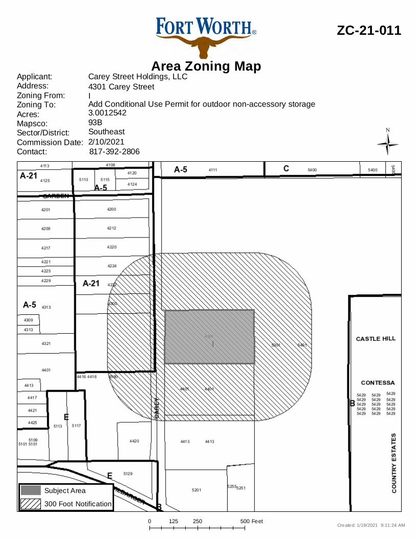
0 250 500125 Feet
Area Zoning Map
ZC-21-011
Applicant: Address:Zoning From:Zoning To:Acres:Mapsco:Sector/District:Commission Date:Contact:
Carey Street Holdings, LLC
93B3.0012542Add Conditional Use Permit for outdoor non-accessory storageI4301 Carey Street
817-392-28062/10/2021Southeast
Created: 1/19/2021 9:11:24 AM
Subject Area300 Foot Notification
Ü

50
' B
UIL
DIN
G
SE
TB
AC
K L
IN
E
LOT 1-A, BLOCK 1-R
FRANK COLLINS SUBDIVISION
CAB. B, SLIDE 2221
P.R.T.C.T.
CA
RE
Y S
TR
EE
T
(70-F
OO
T W
ID
E R
IG
HT
-O
F-W
AY
)
5' UTILITY EASEMENT
CAB. B, SLIDE 2221
P.R.T.C.T.
5' UTILITY EASEMENT
CAB. B, SLIDE 2221
P.R.T.C.T.
LOT 1, BLOCK 1
LAWHON INDUSTRIAL/STORAGE DEVELOPMENT
DOC. NO. D215241042
P.R.T.C.T.
EX ZONING: I
LAND USE: TRAILER STORAGE
LOT 1-B, BLOCK 1-R
FRANK COLLINS SUBDIVISION
CAB. B, SLIDE 2221
P.R.T.C.T.
EX ZONING: I
LAND USE: EQUIPMENT STORAGE/
OFFICE BUILDING
LOT 20, BLOCK 7
HOME ACRES ADDITION
EX ZONING: A-21
LAND USE: EQUIPMENT STORAGE
LOT 19, BLOCK 7
HOME ACRES ADDITION
EX ZONING: A-21
LAND USE: EQUIPMENT STORAGE
LOT 18, BLOCK 7
HOME ACRES ADDITION
EX ZONING: A-21
LAND USE: EQUIPMENT STORAGE
LOT 21, BLOCK 7
HOME ACRES ADDITION
EX ZONING: A-21
LAND USE: EQUIPMENT STORAGE
LOT 17, BLOCK 7
HOME ACRES ADDITION
EX ZONING: I
LAND USE: EQUIPMENT STORAGE
LOT 16, BLOCK 7
HOME ACRES ADDITION
EX ZONING: I
LAND USE: EQUIPMENT STORAGE/
OFFICE BUILDING
OH
EO
HE
OH
EO
HE
OH
EO
HE
OH
EO
HE
D
D
HAUL
DUMPSTER
WASTE
DUMPSTER
CONNEX DRY
STORAGE
CONTAINER
10
.0
'
36.0' 18.0'
10
.0
'
EX. 8' TALL CHAINLINK
SECURITY FENCE
W/ VINYL SLATS
(TO REMAIN)
EX. 8' TALL CHAINLINK
SECURITY FENCE
W/ VINYL SLATS
(TO REMAIN)
EX. 8' TALL CHAINLINK
SECURITY FENCE
W/ VINYL SLATS
(TO REMAIN)
EX. 8' TALL CHAINLINK
SECURITY FENCE
W/ VINYL SLATS
(TO REMAIN)
EX. 8' TALL VEHICULAR
SECURITY GATE
(TO REMAIN)
PROPOSED USE:
EMPLOYEE PARKING
PROPOSED USE:
VEHICLE AND
EQUIPMENT
PARKING (SEE
EXAMPLE B)
PROPOSED USE:
STORAGE OF MATERIALS,
MULCH, STONE, SOIL, SITE
FURNISHINGS, PLANTS.
EX. POWER POLE W/
STREET LIGHT
(TO REMAIN)
EX. RETAINING WALL
(TO BE REMOVED)
EX. RETAINING WALL
(TO BE REMOVED)
EX
. C
ON
CR
ET
E
DR
IV
E
EX. GRAVEL
PAVEMENT
(TO REMAIN)
EX. GRAVEL
PAVEMENT
(TO REMAIN)
EX. GRAVEL
PAVEMENT
(TO REMAIN)
EX. GRAVEL
PAVEMENT
(TO REMAIN)
(SEE EXAMPLE A)
HILLS
ID
E
HU
GH
ES
TA
HO
E
KELLIS
M
O
O
R
V
I
E
W
BAYLOR
GRIGGS
QUAIL
JENNIFER
VIRGIL
REED
EMERSON
M
O
U
N
T
C
A
S
T
L
E
FR
ES
HF
IE
LD
ED
GE
WO
OD
WILH
ELM
BU
RK
E
CA
RM
EL
TA
HO
E
HU
GH
ES
TAHOE
JANA
LOIS
NORRIS
CR
OU
CH
H
A
T
C
H
E
R
H
U
G
H
E
S
Prairie Dog
Park
Pate
Park
Village
Creek
Park
A
N
G
L
I
N
PECOS
HARDEMAN
R
IM
B
E
Y
WILBARGER
EASTLAND
HILLD
ALE
REED
E BERRY
CLO
TE
LL
LA
UR
ET
TA
CA
ND
AC
E
RA
PH
AE
L
WA
LD
OR
F
BE
RN
IC
E
FA
RR
ELL
GRAYSON
MONTAGUE
BAYLOR
OAKDALE
ASBURY
WILKES
WILBARGER
E BERRY
DOWDELL
CR
AV
EN
S
PINSON
TURNER
COX
CA
RE
Y
BU
RG
ER
NORRIS
RICHARDSON
TURNER
BR
AD
Y
NE
LM
S
BIG BEAR
L
A
K
E
CA
RE
Y
MARTIN
DAVID STRICKLAND
VESTA FARLEY
LASTER
KALTENBRUN
DAVID STRICKLAND
VESTA FARLEY
LASTER
SUN VALLEY
CA
ME
RO
N
VA
NC
OU
VE
R
RU
TH
A
NN
CH
AR
LO
TT
E
PR
ES
TO
N
ST
ALLC
UP
B
ra
n
ch
2
.
8
MA
RIE
JO
NE
S
WHITTLESEY
FORT
WORTH
A
R
L
I
N
G
T
O
N
1.5
S
A
G
U
A
R
O
C
H
A
M
P
L
A
I
N
KALTENBRUN
R
E
E
D
RICHARD-
SON
LO
LA
BR
IE
RY
CR
AV
EN
S
EASTLAND
RA
DF
OR
D
Willian McDonald
Park
VIRGIL
Q
U
A
IL
CA
RV
ER
LY
L
A
K
E
M
E
A
D
BERRY
287
820
820
287
NO
SR
ED
NE
H-
RE
KR
AP
K
E
E
R
C
EG
AL
LI
V
NORTH
0
GRAPHIC SCALE IN FEET
30
15 30 60
CO
ND
IT
IO
NA
L U
SE
P
ER
MIT
SIT
E P
LA
N
C1.00
SITE DATA
ZONING
1. ALL PROVIDED LIGHTING SHALL CONFORM TO CITY OF FORT WORTH LIGHTING
CODE.
2. ALL SIGNAGE SHALL CONFORM TO ARTICLE 4, SIGNS.
3. THIS PROJECT SHALL COMPLY WITH SECTION 6.301, LANDSCAPING.
4. THIS PROJECT SHALL COMPLY WITH SECTION 6.302, URBAN FORESTRY.
NOTES:
PROJECT
LOCATION
SCALE: 1"=2000'
N
CONDITIONAL USE PERMIT
CLEAN SCAPES
4301 CAREY STREET
OUTDOOR STORAGE LOT
FORT WORTH, TX
JANUARY 2021
DIRECTOR OF PLANNING AND DEVELOPMENT DATE
ZC-__-___
BY
DA
TE
AS
S
HO
WN
RE
VIS
IO
NS
No
.D
AT
E
SHEET NUMBER
CH
EC
KE
D B
Y
SC
ALE
DE
SIG
NE
D B
Y
DR
AW
N B
Y
KH
A P
RO
JE
CT
80
1 C
HE
RR
Y S
TR
EE
T, U
NIT
1
1, S
UIT
E 1
30
0, F
OR
T W
OR
TH
, T
X 7
61
02
PH
ON
E: 8
17
-3
35
-6
51
1
WW
W.K
IM
LE
Y-H
OR
N.C
OM
T
X F
-9
28
CLE
AN
S
CA
PE
S
4301 C
AR
EY
S
TR
EE
T
FR
AN
K C
OL
LIN
S S
UB
DIV
IS
IO
N
CIT
Y O
F F
OR
T W
OR
TH
, T
EX
AS
KH
KH
KH
06
13
13
70
0
Not for construction purposes or permits.
FOR REVIEW ONLY
Engineer
P.E. No. Date
Prepared for Concept Plan submittal
JAN 2021100185
BRANDON D. MIDDLETON
JA
NU
AR
Y 2
02
1
TH
IS
D
OC
UM
EN
T, T
OG
ET
HE
R W
IT
H T
HE
C
ON
CE
PT
S A
ND
D
ES
IG
NS
P
RE
SE
NT
ED
H
ER
EIN
, A
S A
N IN
ST
RU
ME
NT
O
F S
ER
VIC
E, IS
IN
TE
ND
ED
O
NLY
F
OR
T
HE
S
PE
CIF
IC
P
UR
PO
SE
A
ND
C
LIE
NT
F
OR
W
HIC
H IT
W
AS
P
RE
PA
RE
D. R
EU
SE
OF
A
ND
IM
PR
OP
ER
R
ELIA
NC
E O
N T
HIS
D
OC
UM
EN
T W
IT
HO
UT
W
RIT
TE
N A
UT
HO
RIZ
AT
IO
N A
ND
A
DA
PT
AT
IO
N B
Y K
IM
LE
Y-H
OR
N A
ND
A
SS
OC
IA
TE
S, IN
C. S
HA
LL B
E W
IT
HO
UT
LIA
BILIT
Y T
O K
IM
LE
Y-H
OR
N A
ND
A
SS
OC
IA
TE
S, IN
C.
HAUL AND WASTE DUMPSTER EXAMPLE
A
N.T.S.
VEHICLE AND EQUIPMENT EXAMPLE
B
N.T.S.
EXISTING LAND USE
PROPOSED USE
LEGAL
DESCRIPTION
LOT 1-A, BLOCK 1-R
FRANK COLLINS SUBDIVISION
STORAGE
STORAGE
I - LIGHT INDUSTRIAL
REQUIRED PARKING
0 (0)
LEGEND
PROPERTY LINE
EASEMENT
SETBACK LINE
EXISTING FENCE
X X
CAREY STREET HOLDINGS, LLC
(A CLEAN SCAPES AFFILIATE)
4800 W. HOWARD LANE
AUSTIN, TX 78728
PHONE: 512-448-1094
CONTACT: DAMIEN MATHERNE
KIMLEY-HORN & ASSOCIATES, INC.801 CHERRY STREET, UNIT 11, SUITE 1300FORT WORTH, TEXAS 76102CONTACT: BRANDON MIDDLETON, P.E.PHONE: 817-339-2275TX ENGR. FIRM F-928
OWNER:
ENGINEER:
EXISTING GRAVEL PAVEMENT
(TO REMAIN)
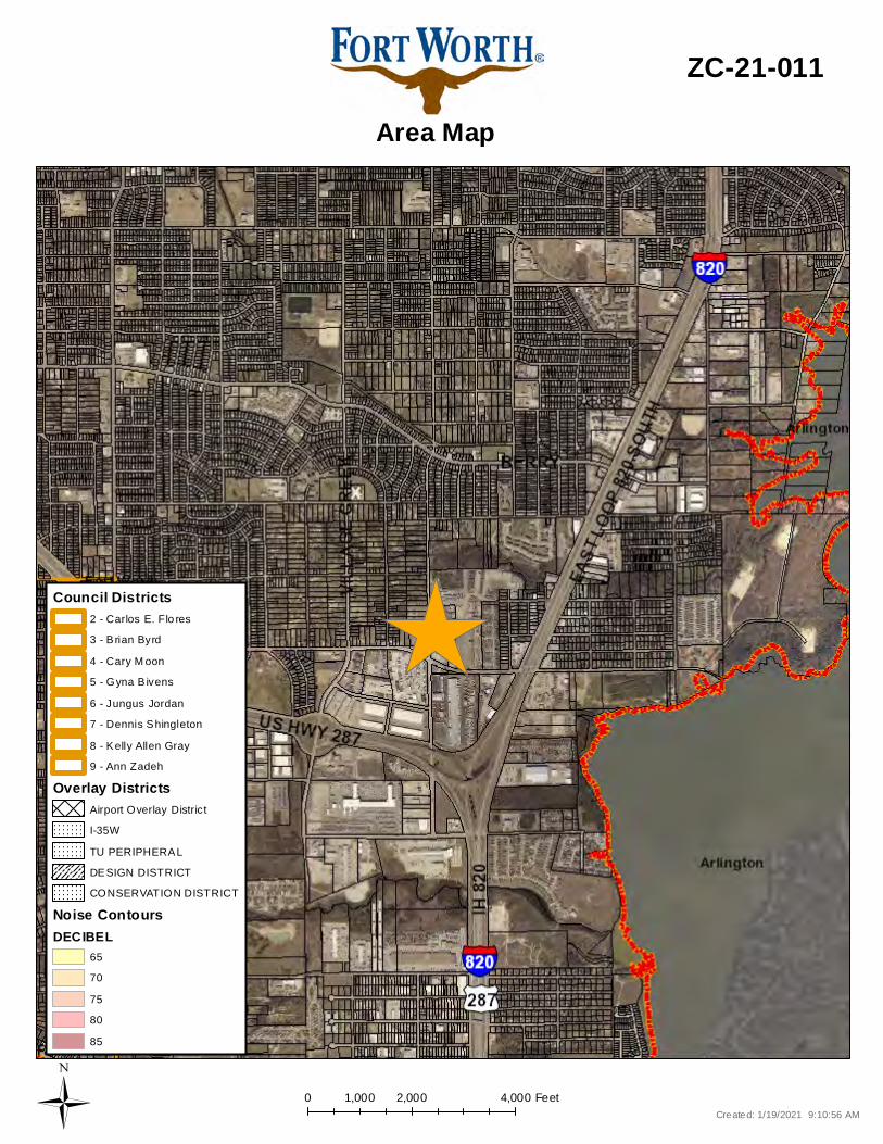
0 2,000 4,0001,000 Feet
Area Map
ZC-21-011
Created: 1/19/2021 9:10:56 AMÜ
CONSERVATION DISTRICT
Overlay DistrictsAirport Overlay DistrictI-35WTU PERIPHERALDESIGN DISTRICT
Noise ContoursDECIBEL
6570758085
Council Districts
4 - Cary M oon5 - Gyna B ivens6 - Jungus Jordan7 - Dennis Shingleton8 - Kelly Allen Gray9 - Ann Zadeh
3 - B rian Byrd2 - Carlos E. Flo res

225 0 225112.5 FeetA Com prehens iv e P lan shall not c ons titu te z oning r egulations ores tab l is h z oning d istrict boundaries . (Texas Loc al Governm ent Code, S ection 213.005.) Land use des ignations were approv ed by City Counci l on M arc h 6, 2018.
Future Land Use
ZC-21-011
Cr eated: 1 /19/2021 9 :11:46 AMÜ
Vacant, Undeveloped, AgriculturalRural ResidentialSuburban ResidentialSingle Family ResidentialManufactured HousingLow Density Res ident ialMedium Density ResidentialHigh Density R esident ial
InstitutionalNeighborhood CommercialGeneral CommercialLight Indus trialHeavy IndustrialMixed-UseIndustrial Growth CenterInfras truc ture100 Year Flood PlainPublic Park, Recreation, Open SpacePrivate Park, Recreat ion, Open SpaceLakes and Ponds
CMU - Commercial Mixed Use StreetNC - Neighborhood Connector
A - Ac tivity StreetCMCO - Commerc ial C onnec tor
SL - System Link
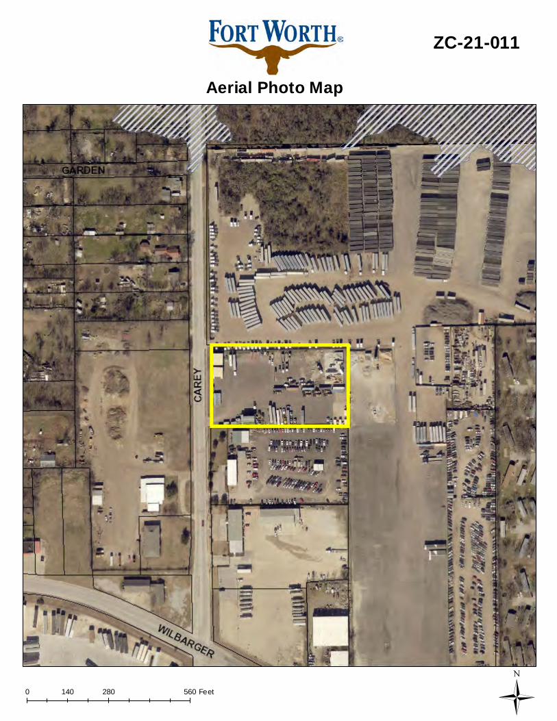
0 280 560140 Feet
Aerial Photo Map
ZC-21-011
Ü
Page 1 of 2
Case Number _ZC-21-012_
ZONING MAP CHANGE STAFF REPORT
Zoning Commission Meeting Date: Council District 6 February 10, 2021
Continued Yes __ No _X_ Case Manager _Laura Evans _ Surplus Yes ___ No _X_ Council Initiated Yes ___ No _X_
Owner / Applicant: Bloomfield Homes, LP Site Location: 9901 & 10400-10600 blocks Crowley Rd, 1301 W. Risinger Rd
Acreage: 153.87 Proposed Use: Single Family, Multifamily, Commercial Request: From: “A-5” One Family, “C” Medium Density Multifamily, and “E” Neighborhood
Commercial
To: “A-5” One Family, “C” Medium Density Multifamily, and “E” Neighborhood Commercial
Land Use Compatibility: Requested change is compatible. Comprehensive Plan Consistency: Requested change is consistent (Minor Boundary
Adjustment. Staff Recommendation: Approval Background: The property is located at the southeast corner of Crowley Road and Risinger Road, the southeast corner of Risinger Road and Hemphill Street, and on the east side of Crowley Road just south of Clark Road. The applicant is proposing a zoning change from “A-5” One Family, “C” Medium Density Multifamily, and “E” Neighborhood Commercial, to the same zoning categories in a different configuration. Below are tables that show the current and proposed zoning of each tract as well as the acreage of each current and proposed zoning category.
Tract Current Zoning Proposed Zoning 1 “A-5” One Family “E” Neighborhood Commercial 2 “A-5” One Family “C” Medium Density Multifamily 3 “C” and “E” “E” Neighborhood Commercial 4 “C” and “E” “A-5” One Family
Zoning Current Acreage Proposed Acreage Change
A-5 92.58 53.237 -39.343 C 32.25 54.836 +22.586 E 28.983 45.992 +17.009

Page 2 of 2
Site Information: Surrounding Zoning and Land Uses:
The three areas of the proposed rezoning are generally boundary by Crowley Road, Risinger road, and Railroad ROW. Interior to the sites is primarily undeveloped land, with an existing neighborhood of large lot single family. The two streets and neighborhood Collectors on the Master Thoroughfare Plan. Surrounding the exterior of the sites are varying uses, including industrial, single family and commercial uses.
Zoning History: ZC-20-170 from C to A-5, portion of proposed site (rec. approval by ZC 1/13/21) ZC-19-094 from A-5 to A-21; effective 8/29/19; north of portion of proposed site ZC-19-088 from R2 to A-5; effective 2/27/20; south of portion of proposed site
Public Notification: 300 foot Legal Notifications were mailed on January 22, 2021.
The following organizations were notified: (emailed January 19, 2021) Organizations Notified
The Clark Road NA Parkview HOA Risinger Deer Creek HOA The Parks of Deer Creek HOA District 6 Alliance Streams And Valleys Inc Trinity Habitat for Humanity Everman ISD Crowley ISD
*Located within this Neighborhood Association Development Impact Analysis:
1. Land Use Compatibility The applicant is proposing to change the zoning to A-5, C, and E. Surrounding uses consist of primarily undeveloped land. The proposed use is compatible with surrounding uses.
2. Comprehensive Plan Consistency – Far South
The 2020 Comprehensive Plan designates the subject property as Neighborhood Commercial, Single Family, Medium density multifamily, and Open Space. The proposed rezoning meets the below policies within the following Comprehensive Plan: • Locate large commercial and institutional uses adjacent to arterial streets, preferably at the
intersections of other arterials and highways. • Promote measures to ensure that all types of residential developments are compatible in
scale to abutting residential developments. A dramatic difference in lot size and units per acre should be discouraged for new development immediately adjacent to existing development or platted and zoned property, unless mitigation is provided to minimize the effects of the new use.
• Separate incompatible land uses with buffers or transitional uses. Some land uses have attributes such as height, proportion, scale, operational characteristics, traffic generated, or appearance that may not be compatible with the attributes of other uses.
Based on conformance with the policies stated above, the proposed zoning is consistent (Minor Boundary Adjustment) with the Comprehensive Plan.
Attachments:
• Area Zoning Map with 300 ft. Notification Area • Exhibit • Area Map • Future Land Use Map • Aerial Photograph
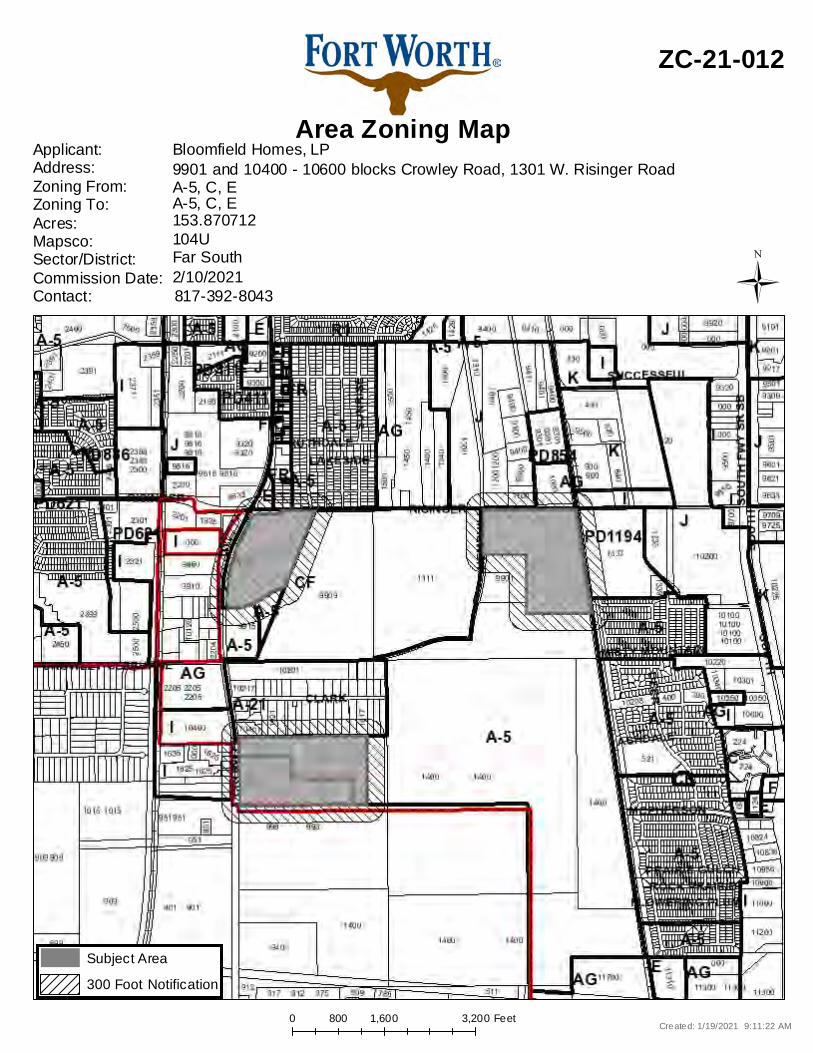
0 1,600 3,200800 Feet
Area Zoning Map
ZC-21-012
Applicant: Address:Zoning From:Zoning To:Acres:Mapsco:Sector/District:Commission Date:Contact:
Bloomfield Homes, LP
104U153.870712A-5, C, EA-5, C, E9901 and 10400 - 10600 blocks Crowley Road, 1301 W. Risinger Road
817-392-80432/10/2021Far South
Created: 1/19/2021 9:11:22 AM
Subject Area300 Foot Notification
Ü

W. RISINGER ROAD
M.K
.&T. R
AIL
RO
AD
NO
RT
H C
RO
WLE
Y R
OA
DF.M
. 731
PROPOSED ZONING:"E" NEIGHBORHOOD COMMERCIAL
PROPOSED ZONING:SINGLE FAMILY A-5
HE
MP
HIL
L S
TR
EE
T
PROPOSED ZONING:MULTIFAMILY "C"
PRO
POSE
D Z
ON
ING
:"E
"N
EIG
HBO
RHO
OD
CO
MM
ERC
IAL
TRACT 254.836 ACRES
TRACT 453.237 ACRES
TRACT 38.248 ACRES
TRA
CT 1
37.7
44 A
CRE
S
Sheet
of
Job No.: Scale:
Drafted: Checked:
Date Prepared:
E:\1
0805
- D
eer C
reek
Mea
dow
\CO
GO
\BLO
OM
FIEL
D Z
ON
ING
\OV
ERA
LL Z
ON
ING
DIS
PLA
Y.d
wg
1,0000
SCALE IN FEET
GMOODWINARSHALL
CIVIL ENGINEERS ~ PLANNERS ~ SURVEYORS
AN
D
INC
.
2405 Mustang Drive, Grapevine, Texas 76051(817) 329 - 4373
TxEng Firm # F-2944 ~ TxSurv Firm # 10021700
10805 1"=1000'
T.J.M.
1/21/2021
1
1
PROPOSED ZONING DISPLAYDEER CREEK MEADOWS
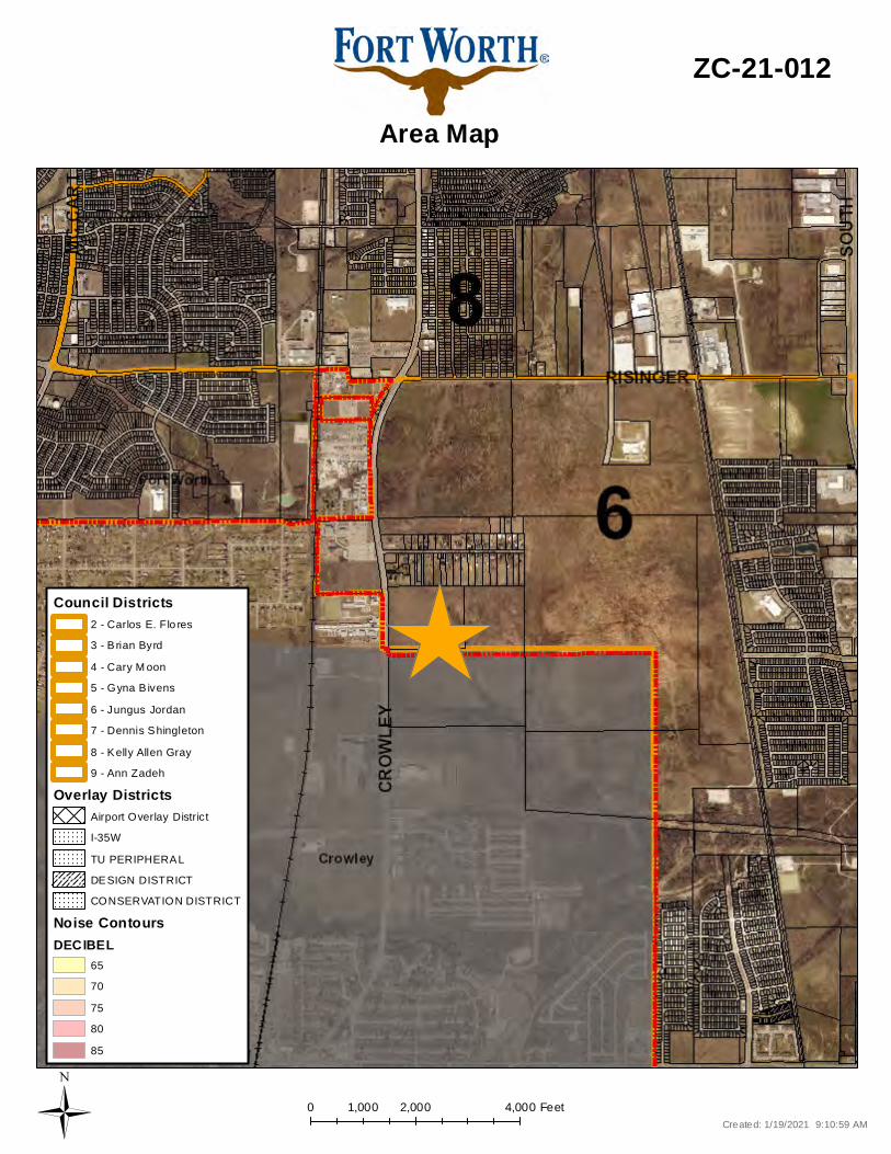
0 2,000 4,0001,000 Feet
Area Map
ZC-21-012
Created: 1/19/2021 9:10:59 AMÜ
CONSERVATION DISTRICT
Overlay DistrictsAirport Overlay DistrictI-35WTU PERIPHERALDESIGN DISTRICT
Noise ContoursDECIBEL
6570758085
Council Districts
4 - Cary M oon5 - Gyna B ivens6 - Jungus Jordan7 - Dennis Shingleton8 - Kelly Allen Gray9 - Ann Zadeh
3 - B rian Byrd2 - Carlos E. Flo res
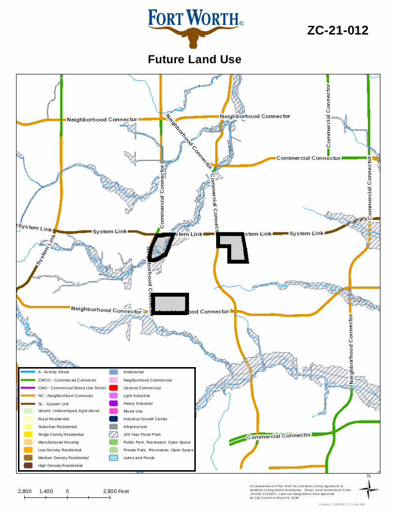
2,800 0 2,8001,400 FeetA Com prehens iv e P lan shall not c ons titu te z oning r egulations ores tab l is h z oning d istrict boundaries . (Texas Loc al Governm ent Code, S ection 213.005.) Land use des ignations were approv ed by City Counci l on M arc h 6, 2018.
Future Land Use
ZC-21-012
Cr eated: 1 /19/2021 9 :11:44 AMÜ
Vacant, Undeveloped, AgriculturalRural ResidentialSuburban ResidentialSingle Family ResidentialManufactured HousingLow Density Res ident ialMedium Density ResidentialHigh Density R esident ial
InstitutionalNeighborhood CommercialGeneral CommercialLight Indus trialHeavy IndustrialMixed-UseIndustrial Growth CenterInfras truc ture100 Year Flood PlainPublic Park, Recreation, Open SpacePrivate Park, Recreat ion, Open SpaceLakes and Ponds
CMU - Commercial Mixed Use StreetNC - Neighborhood Connector
A - Ac tivity StreetCMCO - Commerc ial C onnec tor
SL - System Link
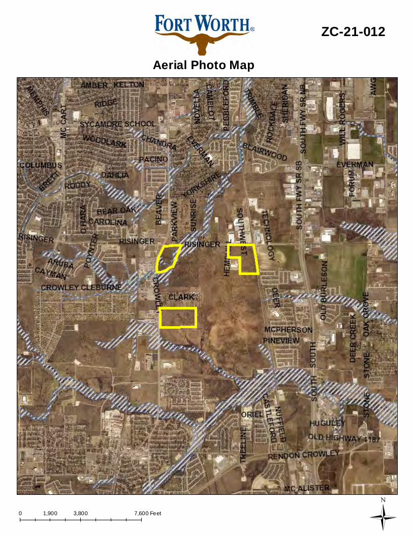
0 3,800 7,6001,900 Feet
Aerial Photo Map
ZC-21-012
Ü

Page 1 of 4
Case Number _ZC-21-013_
ZONING MAP CHANGE STAFF REPORT
Zoning Commission Meeting Date: Council District 6 February 10, 2021
Continued Yes __ No _X_ Case Manager _Laura Evans _ Surplus Yes ___ No _X_ Council Initiated Yes ___ No _X_
Owner / Applicant: Gabriel Southwest LLC Site Location: 9500 - 9700 blocks Brewer Boulevard Acreage: 19.001 Proposed Use: Detached Multifamily Request: From: “C” Medium Density Multifamily
To: Planned Development for all uses in “D” High Density Multifamily plus detached multifamily use, with development regulations for building orientation, fencing, and open space; waiver to MFD submittal for cottage community only; site plan included
Land Use Compatibility: Requested change is compatible. Comprehensive Plan Consistency: Requested change is consistent. Staff Recommendation: Approval Background: The requested zoning change is located south of the intersection of McPherson Road and Brewer Road, both streets on the Master Thoroughfare Plan. The property is currently zoned “C” Medium Density Multifamily. The applicant is proposing a zoning change to “PD/D” with development standards in order to create a detached multifamily development. The applicant is proposing a zoning change to create a detached multifamily development. These types of developments are entire communities and neighborhoods that look and feel like a traditional single family neighborhood. Although most are rental, some may be rent-to-own or condominium. Like other multifamily developments, they are professionally managed and include amenities. These developments provide renters with an option that looks and feels like a single family neighborhood. According to the National Association of Home Builders, 37,000 of these units were built in 2017 and 43,000 in 2018 nationwide. Although the national trend has slowed recently, an increase has been seen in Fort Worth. As none of the city’s districts can accommodate this form by right, a Planned Development (PD) with new development regulations is necessary to allow this form. In this case, the developer has provided a list of development regulations that will be part of this Planned Development. The developer has provided specific site amenities in order to meet their enhanced landscaping requirements, found in section IV.c of the development standards. The development is requesting waivers to setback standards. Below is a chart that illustrates the differences between the base “C” regulations and the proposed PD.
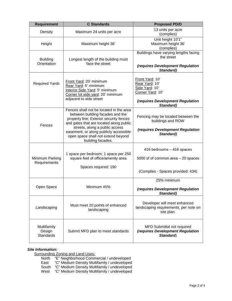
Page 2 of 4
Requirement C Standards Proposed PD/D
Density Maximum 24 units per acre 13 units per acre (complies)
Height Maximum height 36’ Unit height 10’1”
Maximum height 36’ (complies)
Building Orientation
Longest length of the building must face the street
Buildings have varying lengths facing the street
(requires Development Regulation
Standard)
Required Yards
Front Yard: 20’ minimum Rear Yard: 5’ minimum Interior Side Yard: 5’ minimum Corner lot side yard: 20’ minimum adjacent to side street
Front Yard: 10’ Rear Yard: 10’ Side Yard: 10’ Corner Yard: 10’ (requires Development Regulation
Standard)
Fences
Fences shall not be located in the area between building facades and the
property line; Exterior security fences and gates that are located along public
streets, along a public access easement, or along publicly accessible open space shall not extend beyond
building facades.
Fencing may be located between the buildings and ROW
(requires Development Regulation
Standard)
Minimum Parking Requirements
1 space per bedroom; 1 space per 250 square feet of office/amenity area
Spaces required: 190
416 bedrooms – 416 spaces
5000 sf of common area – 20 spaces
(Complies - Spaces provided: 434)
Open Space Minimum 45% 25% minimum
(requires Development Regulation
Standard)
Landscaping Must meet 20 points of enhanced landscaping
Developer will meet enhanced landscaping requirements, per note on
site plan.
Multifamily Design
Standards Submit MFD plan to meet standards
MFD Submittal not required (requires Development Regulation
Standard)
Site Information:
Surrounding Zoning and Land Uses: North “E” Neighborhood Commercial / undeveloped East “C” Medium Density Multifamily / undeveloped South “C” Medium Density Multifamily / undeveloped West “C” Medium Density Multifamily / undeveloped

Page 3 of 4
Zoning History: None Site Plan Comments: The site plan as submitted is not in general compliance with the Zoning Ordinance regulations.
1. Site has fencing placed between the buildings and street. (requires Development Regulation Standard)
a. Due to the similar nature of detached multifamily to single family developments, staff does not have an issue with the placement of fencing between the building and the street.
2. Site does not meet building orientation requirement. (requires Development Regulation Standard)
a. A majority of the buildings have the longer side facing the street. Additionally, the placement of a fence between the building and the street lessens the importance of this requirement.
3. Site does not meet required setbacks of front or corner yards. (requires Development Regulation Standard)
a. The bulk and height of the proposed buildings are smaller than those seen in typical multifamily developments. The setbacks are similar to those of a single family development
4. Applicant is requesting a waiver to the MFD Submittal. (requires Development Regulation Standard)
a. Due to the unique nature of detached multifamily developments, staff does not feel that the MFD submittal is necessary for development.
(Comments made by Platting (Subdivision Ordinance), Transportation/Public Works, Fire, Park & Recreation, and Water Department staff cannot be waived through the Zoning Commission and City Council. Approval of the zoning site plan does not constitute the acceptance of conditions.)
Public Notification:
300 foot Legal Notifications were mailed on January 22, 2021. The following organizations were notified: (emailed January 19, 2021)
Organizations Notified Panther Heights NA District 6 Alliance Streams And Valleys Inc Trinity Habitat for Humanity Crowley ISD
*Located within this Neighborhood Association Development Impact Analysis:
1. Land Use Compatibility The applicant is proposing to change the zoning to PD/D for a detached multifamily development. The site is surrounded by undeveloped land. The proposed use is compatible with surrounding uses.
2. Comprehensive Plan Consistency – Far Southwest
The 2020 Comprehensive Plan designates the subject property as Medium Density Multifamily. The proposed use meets the below policies within the following Comprehensive Plan:
• Encourage new development adjacent and connected to previously developed or platted areas in order to utilize existing utility and road infrastructure and services, thereby optimizing public and private investments and discouraging sprawl development.
• Separate incompatible land uses with buffers or transitional uses. Some land uses have attributes such as height, proportion, scale, operational characteristics, traffic generated, or appearance that may not be compatible with the attributes of other uses.
Page 4 of 4
• Support diverse housing options, including duplexes, fourplexes, townhomes, and small courtyard apartments to promote walkable communities, access to neighborhood services, and multimodal transportation options, while ensuring compatibility with the form, sale, and design of existing neighborhoods.
Based on conformance with the policies stated above, the proposed zoning is consistent with the Comprehensive Plan.
Attachments:
• Area Zoning Map with 300 ft. Notification Area • Site Plan • Area Map • Future Land Use Map • Aerial Photograph
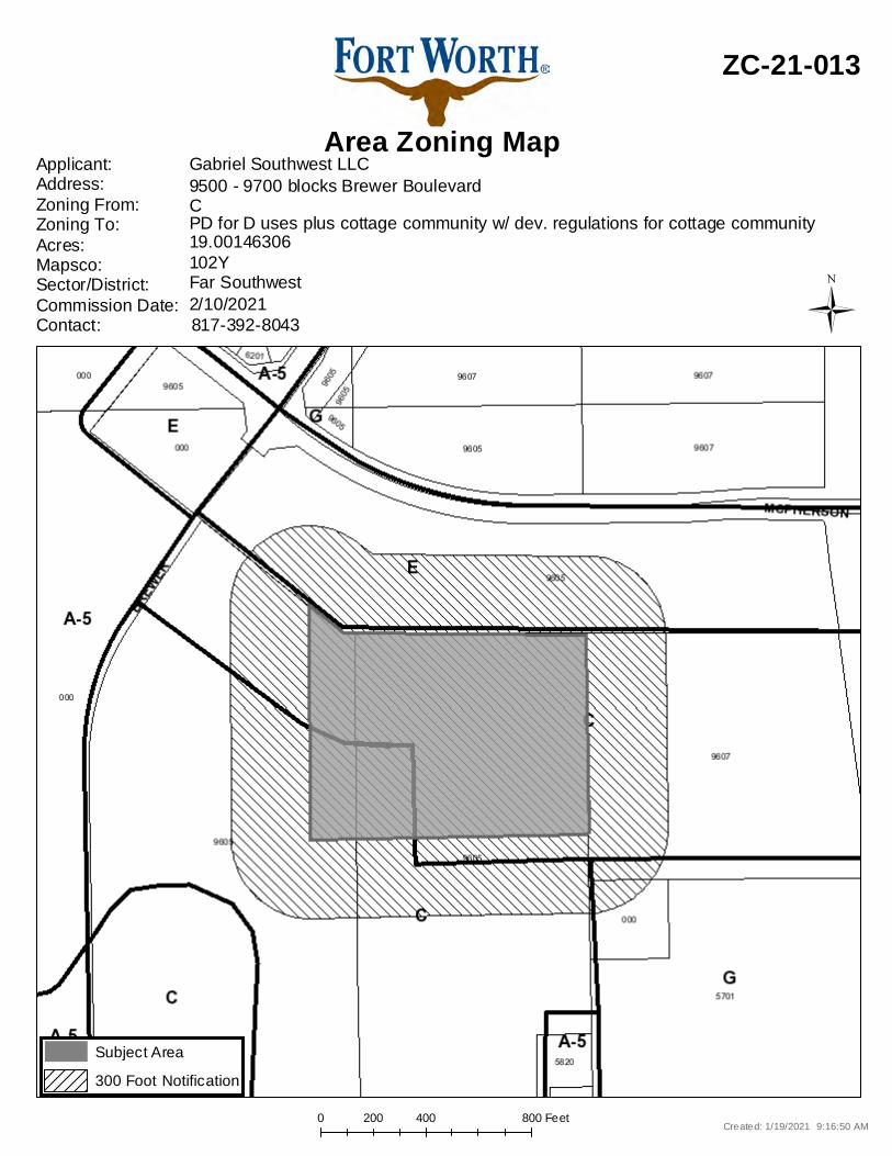
0 400 800200 Feet
Area Zoning Map
ZC-21-013
Applicant: Address:Zoning From:Zoning To:Acres:Mapsco:Sector/District:Commission Date:Contact:
Gabriel Southwest LLC
102Y19.00146306PD for D uses plus cottage community w/ dev. regulations for cottage communityC9500 - 9700 blocks Brewer Boulevard
817-392-80432/10/2021Far Southwest
Created: 1/19/2021 9:16:50 AM
Subject Area300 Foot Notification
Ü
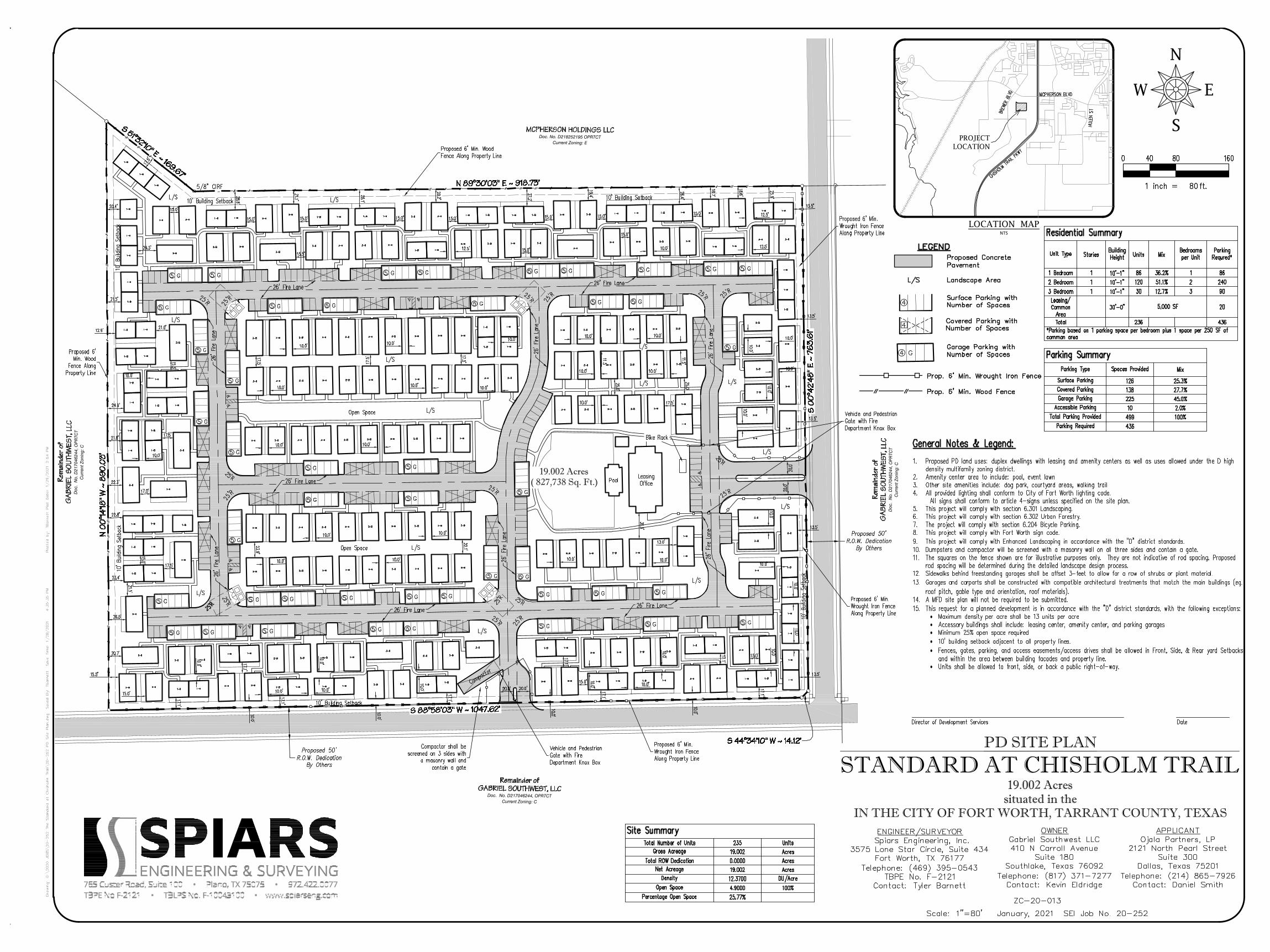
S
N
W E
LOCATION MAPNTS
PD SITE PLAN
STANDARD AT CHISHOLM TRAIL19.002 Acres
situated in theIN THE CITY OF FORT WORTH, TARRANT COUNTY, TEXAS
·····
·
PROJECTLOCATION
Doc. No. D218252195 OPRTCTCurrent Zoning: E
Doc
. N
o. D
2170
4624
4, O
PR
TCT
Cur
rent
Zon
ing:
C
Doc
. N
o. D
2170
4624
4, O
PR
TCT
Cur
rent
Zon
ing:
C
Doc. No. D217046244, OPRTCTCurrent Zoning: C
19.002 Acres( 827,738 Sq. Ft.)
AutoCAD SHX Text
Plotted by: TBarnett Plot Date: 1/29/2021 2:54 PMTBarnett Plot Date: 1/29/2021 2:54 PM Plot Date: 1/29/2021 2:54 PM1/29/2021 2:54 PM
AutoCAD SHX Text
Drawing: G:\2020 JOBS\20-252 The Standard at Chisholm Trail\20-252 PD Site Plan.dwg Saved By: Tbarnett Save Time: 1/28/2021 4:35:35 PMG:\2020 JOBS\20-252 The Standard at Chisholm Trail\20-252 PD Site Plan.dwg Saved By: Tbarnett Save Time: 1/28/2021 4:35:35 PM Saved By: Tbarnett Save Time: 1/28/2021 4:35:35 PMTbarnett Save Time: 1/28/2021 4:35:35 PM Save Time: 1/28/2021 4:35:35 PM1/28/2021 4:35:35 PM
AutoCAD SHX Text
1 inch = ft.
AutoCAD SHX Text
0
AutoCAD SHX Text
40
AutoCAD SHX Text
80
AutoCAD SHX Text
160
AutoCAD SHX Text
80
AutoCAD SHX Text
4
AutoCAD SHX Text
4
AutoCAD SHX Text
4
AutoCAD SHX Text
G
AutoCAD SHX Text
Garage Parking with Number of Spaces
AutoCAD SHX Text
Surface Parking with Number of Spaces
AutoCAD SHX Text
Scale: 1"=80' January, 2021 SEI Job No. 20-252
AutoCAD SHX Text
ENGINEER/SURVEYOR Spiars Engineering, Inc. 3575 Lone Star Circle, Suite 434 Fort Worth, TX 76177 Telephone: (469) 395-0543 TBPE No. F-2121 Contact: Tyler Barnett
AutoCAD SHX Text
OWNER Gabriel Southwest LLC 410 N Carroll Avenue Suite 180 Southlake, Texas 76092 Telephone: (817) 371-7277 Contact: Kevin Eldridge
AutoCAD SHX Text
Parking Summary
AutoCAD SHX Text
Parking Type
AutoCAD SHX Text
Spaces Provided
AutoCAD SHX Text
Mix
AutoCAD SHX Text
Surface Parking
AutoCAD SHX Text
126
AutoCAD SHX Text
25.3%
AutoCAD SHX Text
Covered Parking
AutoCAD SHX Text
138
AutoCAD SHX Text
27.7%
AutoCAD SHX Text
Garage Parking
AutoCAD SHX Text
225
AutoCAD SHX Text
45.0%
AutoCAD SHX Text
Accessible Parking
AutoCAD SHX Text
10
AutoCAD SHX Text
2.0%
AutoCAD SHX Text
Total Parking Provided
AutoCAD SHX Text
499
AutoCAD SHX Text
100%
AutoCAD SHX Text
Parking Required
AutoCAD SHX Text
436
AutoCAD SHX Text
General Notes & Legend: 1. Proposed PD land uses: duplex dwellings with leasing and amenity centers as well as uses allowed under the D high Proposed PD land uses: duplex dwellings with leasing and amenity centers as well as uses allowed under the D high density multifamily zoning district. 2. Amenity center area to include: pool, event lawn Amenity center area to include: pool, event lawn 3. Other site amenities include: dog park, courtyard areas, walking trail Other site amenities include: dog park, courtyard areas, walking trail 4. All provided lighting shall conform to City of Fort Worth lighting code. All provided lighting shall conform to City of Fort Worth lighting code. All signs shall conform to article 4-signs unless specified on the site plan. 5. This project will comply with section 6.301 Landscaping. This project will comply with section 6.301 Landscaping. 6. This project will comply with section 6.302 Urban Forestry. This project will comply with section 6.302 Urban Forestry. 7. The project will comply with section 6.204 Bicycle Parking. The project will comply with section 6.204 Bicycle Parking. 8. This project will comply with Fort Worth sign code. This project will comply with Fort Worth sign code. 9. This project will comply with Enhanced Landscaping in accordance with the "D" district standards. This project will comply with Enhanced Landscaping in accordance with the "D" district standards. 10. Dumpsters and campactor will be screened with a masonry wall on all three sides and contain a gate. Dumpsters and campactor will be screened with a masonry wall on all three sides and contain a gate. 11. The squares on the fence shown are for illustrative purposes only. They are not indicative of rod spacing. Proposed The squares on the fence shown are for illustrative purposes only. They are not indicative of rod spacing. Proposed rod spacing will be determined during the detailed landscape design process. 12. Sidewalks behind freestanding garages shall be offset 3-feet to allow for a row of shrubs or plant material. Sidewalks behind freestanding garages shall be offset 3-feet to allow for a row of shrubs or plant material. 13. Garages and carports shall be constructed with compatible architectural treatments that match the main buildings (eg. Garages and carports shall be constructed with compatible architectural treatments that match the main buildings (eg. roof pitch, gable type and orientation, roof materials). 14. A MFD site plan will not be required to be submitted. A MFD site plan will not be required to be submitted. 15. This request for a planned development is in accordance with the "D" district standards, with the following exceptions: This request for a planned development is in accordance with the "D" district standards, with the following exceptions: Maximum density per acre shall be 13 units per acre Accessory buildings shall include: leasing center, amenity center, and parking garages Minimum 25% open space required 10' building setback adjacent to all property lines. Fences, gates, parking, and access easements/access drives shall be allowed in Front, Side, & Rear yard Setbacks and within the area between building facades and property line. Units shall be allowed to front, side, or back a public right-of-way.
AutoCAD SHX Text
%%ULEGEND
AutoCAD SHX Text
Proposed Concrete
AutoCAD SHX Text
Prop. 6' Min. Wrought Iron Fence
AutoCAD SHX Text
Covered Parking with Number of Spaces
AutoCAD SHX Text
MCPHERSON BLVD
AutoCAD SHX Text
APPLICANT Ojala Partners, LP 2121 North Pearl Street Suite 300 Dallas, Texas 75201 Telephone: (214) 865-7926 Contact: Daniel Smith
AutoCAD SHX Text
Residential Summary
AutoCAD SHX Text
Unit Type
AutoCAD SHX Text
Stories
AutoCAD SHX Text
Building Height
AutoCAD SHX Text
Units
AutoCAD SHX Text
Mix
AutoCAD SHX Text
Bedrooms per Unit
AutoCAD SHX Text
Parking Requred*
AutoCAD SHX Text
1 Bedroom
AutoCAD SHX Text
1
AutoCAD SHX Text
10'-1"
AutoCAD SHX Text
86
AutoCAD SHX Text
36.2%
AutoCAD SHX Text
1
AutoCAD SHX Text
86
AutoCAD SHX Text
2 Bedroom
AutoCAD SHX Text
1
AutoCAD SHX Text
10'-1"
AutoCAD SHX Text
120
AutoCAD SHX Text
51.1%
AutoCAD SHX Text
2
AutoCAD SHX Text
240
AutoCAD SHX Text
3 Bedroom
AutoCAD SHX Text
1
AutoCAD SHX Text
10'-1"
AutoCAD SHX Text
30
AutoCAD SHX Text
12.7%
AutoCAD SHX Text
3
AutoCAD SHX Text
90
AutoCAD SHX Text
Leasing/ Common Area
AutoCAD SHX Text
30'-0"
AutoCAD SHX Text
5,000 SF
AutoCAD SHX Text
20
AutoCAD SHX Text
Total
AutoCAD SHX Text
236
AutoCAD SHX Text
436
AutoCAD SHX Text
*Parking based on 1 parking space per bedroom plus 1 space per 250 SF of common area
AutoCAD SHX Text
Site Summary
AutoCAD SHX Text
Total Number of Units
AutoCAD SHX Text
235
AutoCAD SHX Text
Units
AutoCAD SHX Text
Gross Acreage
AutoCAD SHX Text
19.002
AutoCAD SHX Text
Acres
AutoCAD SHX Text
Total ROW Dedication
AutoCAD SHX Text
0.0000
AutoCAD SHX Text
Acres
AutoCAD SHX Text
Net Acreage
AutoCAD SHX Text
19.002
AutoCAD SHX Text
Acres
AutoCAD SHX Text
Density
AutoCAD SHX Text
12.3700
AutoCAD SHX Text
DU/Acre
AutoCAD SHX Text
Open Space
AutoCAD SHX Text
4.9000
AutoCAD SHX Text
100%
AutoCAD SHX Text
Percentage Open Space
AutoCAD SHX Text
25.77%
AutoCAD SHX Text
3
AutoCAD SHX Text
3
AutoCAD SHX Text
3
AutoCAD SHX Text
3
AutoCAD SHX Text
2
AutoCAD SHX Text
4
AutoCAD SHX Text
4
AutoCAD SHX Text
5
AutoCAD SHX Text
3
AutoCAD SHX Text
3
AutoCAD SHX Text
3
AutoCAD SHX Text
2
AutoCAD SHX Text
5
AutoCAD SHX Text
5
AutoCAD SHX Text
5
AutoCAD SHX Text
5
AutoCAD SHX Text
4
AutoCAD SHX Text
4
AutoCAD SHX Text
3
AutoCAD SHX Text
4
AutoCAD SHX Text
4
AutoCAD SHX Text
2
AutoCAD SHX Text
3
AutoCAD SHX Text
1
AutoCAD SHX Text
8
AutoCAD SHX Text
12
AutoCAD SHX Text
1
AutoCAD SHX Text
1
AutoCAD SHX Text
4
AutoCAD SHX Text
4
AutoCAD SHX Text
4
AutoCAD SHX Text
3
AutoCAD SHX Text
3
AutoCAD SHX Text
3
AutoCAD SHX Text
1
AutoCAD SHX Text
4
AutoCAD SHX Text
3
AutoCAD SHX Text
2
AutoCAD SHX Text
5
AutoCAD SHX Text
5
AutoCAD SHX Text
4
AutoCAD SHX Text
5
AutoCAD SHX Text
5
AutoCAD SHX Text
5
AutoCAD SHX Text
5
AutoCAD SHX Text
5
AutoCAD SHX Text
4
AutoCAD SHX Text
5
AutoCAD SHX Text
5
AutoCAD SHX Text
5
AutoCAD SHX Text
5
AutoCAD SHX Text
5
AutoCAD SHX Text
5
AutoCAD SHX Text
5
AutoCAD SHX Text
5
AutoCAD SHX Text
5
AutoCAD SHX Text
5
AutoCAD SHX Text
5
AutoCAD SHX Text
5
AutoCAD SHX Text
5
AutoCAD SHX Text
5
AutoCAD SHX Text
5
AutoCAD SHX Text
5
AutoCAD SHX Text
5
AutoCAD SHX Text
5
AutoCAD SHX Text
5
AutoCAD SHX Text
5
AutoCAD SHX Text
G
AutoCAD SHX Text
5
AutoCAD SHX Text
G
AutoCAD SHX Text
5
AutoCAD SHX Text
G
AutoCAD SHX Text
5
AutoCAD SHX Text
G
AutoCAD SHX Text
5
AutoCAD SHX Text
G
AutoCAD SHX Text
5
AutoCAD SHX Text
G
AutoCAD SHX Text
5
AutoCAD SHX Text
G
AutoCAD SHX Text
5
AutoCAD SHX Text
G
AutoCAD SHX Text
5
AutoCAD SHX Text
G
AutoCAD SHX Text
5
AutoCAD SHX Text
G
AutoCAD SHX Text
5
AutoCAD SHX Text
G
AutoCAD SHX Text
5
AutoCAD SHX Text
G
AutoCAD SHX Text
5
AutoCAD SHX Text
G
AutoCAD SHX Text
5
AutoCAD SHX Text
G
AutoCAD SHX Text
5
AutoCAD SHX Text
G
AutoCAD SHX Text
5
AutoCAD SHX Text
G
AutoCAD SHX Text
5
AutoCAD SHX Text
G
AutoCAD SHX Text
5
AutoCAD SHX Text
G
AutoCAD SHX Text
5
AutoCAD SHX Text
G
AutoCAD SHX Text
5
AutoCAD SHX Text
G
AutoCAD SHX Text
5
AutoCAD SHX Text
G
AutoCAD SHX Text
5
AutoCAD SHX Text
G
AutoCAD SHX Text
5
AutoCAD SHX Text
G
AutoCAD SHX Text
5
AutoCAD SHX Text
G
AutoCAD SHX Text
5
AutoCAD SHX Text
G
AutoCAD SHX Text
5
AutoCAD SHX Text
G
AutoCAD SHX Text
5
AutoCAD SHX Text
G
AutoCAD SHX Text
5
AutoCAD SHX Text
G
AutoCAD SHX Text
5
AutoCAD SHX Text
G
AutoCAD SHX Text
5
AutoCAD SHX Text
G
AutoCAD SHX Text
5
AutoCAD SHX Text
G
AutoCAD SHX Text
5
AutoCAD SHX Text
G
AutoCAD SHX Text
5
AutoCAD SHX Text
G
AutoCAD SHX Text
5
AutoCAD SHX Text
G
AutoCAD SHX Text
5
AutoCAD SHX Text
G
AutoCAD SHX Text
5
AutoCAD SHX Text
G
AutoCAD SHX Text
5
AutoCAD SHX Text
G
AutoCAD SHX Text
5
AutoCAD SHX Text
G
AutoCAD SHX Text
5
AutoCAD SHX Text
G
AutoCAD SHX Text
5
AutoCAD SHX Text
G
AutoCAD SHX Text
5
AutoCAD SHX Text
G
AutoCAD SHX Text
5
AutoCAD SHX Text
G
AutoCAD SHX Text
5
AutoCAD SHX Text
G
AutoCAD SHX Text
5
AutoCAD SHX Text
G
AutoCAD SHX Text
5
AutoCAD SHX Text
G
AutoCAD SHX Text
CHISHOLM TRAIL PKWY
AutoCAD SHX Text
BREWER BLVD
AutoCAD SHX Text
HULEN ST
AutoCAD SHX Text
Director of Development Services
AutoCAD SHX Text
Date
AutoCAD SHX Text
ZC-20-013
AutoCAD SHX Text
Prop. 6' Min. Wood Fence
AutoCAD SHX Text
Pavement
AutoCAD SHX Text
Landscape Area
AutoCAD SHX Text
L/S
AutoCAD SHX Text
Leasing Office
AutoCAD SHX Text
Pool
AutoCAD SHX Text
Open Space
AutoCAD SHX Text
Open Space
AutoCAD SHX Text
10' Building Setback
AutoCAD SHX Text
10' Building Setback
AutoCAD SHX Text
10' Building Setback
AutoCAD SHX Text
10' Building Setback
AutoCAD SHX Text
10' Building Setback
AutoCAD SHX Text
MCPHERSON HOLDINGS LLC
AutoCAD SHX Text
Remainder of GABRIEL SOUTHWEST, LLC
AutoCAD SHX Text
Remainder of GABRIEL SOUTHWEST, LLC
AutoCAD SHX Text
Remainder of GABRIEL SOUTHWEST, LLC
AutoCAD SHX Text
Compactor
AutoCAD SHX Text
3-B
AutoCAD SHX Text
2-B
AutoCAD SHX Text
3-B
AutoCAD SHX Text
3-B
AutoCAD SHX Text
3-B
AutoCAD SHX Text
3-B
AutoCAD SHX Text
3-B
AutoCAD SHX Text
3-B
AutoCAD SHX Text
3-B
AutoCAD SHX Text
3-B
AutoCAD SHX Text
3-B
AutoCAD SHX Text
2-B
AutoCAD SHX Text
2-B
AutoCAD SHX Text
2-B
AutoCAD SHX Text
2-B
AutoCAD SHX Text
2-B
AutoCAD SHX Text
2-B
AutoCAD SHX Text
2-B
AutoCAD SHX Text
2-B
AutoCAD SHX Text
2-B
AutoCAD SHX Text
2-B
AutoCAD SHX Text
2-B
AutoCAD SHX Text
2-B
AutoCAD SHX Text
2-B
AutoCAD SHX Text
2-B
AutoCAD SHX Text
2-B
AutoCAD SHX Text
2-B
AutoCAD SHX Text
2-B
AutoCAD SHX Text
2-B
AutoCAD SHX Text
2-B
AutoCAD SHX Text
2-B
AutoCAD SHX Text
2-B
AutoCAD SHX Text
2-B
AutoCAD SHX Text
2-B
AutoCAD SHX Text
2-B
AutoCAD SHX Text
2-B
AutoCAD SHX Text
2-B
AutoCAD SHX Text
2-B
AutoCAD SHX Text
2-B
AutoCAD SHX Text
2-B
AutoCAD SHX Text
2-B
AutoCAD SHX Text
2-B
AutoCAD SHX Text
2-B
AutoCAD SHX Text
2-B
AutoCAD SHX Text
2-B
AutoCAD SHX Text
2-B
AutoCAD SHX Text
2-B
AutoCAD SHX Text
2-B
AutoCAD SHX Text
2-B
AutoCAD SHX Text
2-B
AutoCAD SHX Text
2-B
AutoCAD SHX Text
2-B
AutoCAD SHX Text
2-B
AutoCAD SHX Text
2-B
AutoCAD SHX Text
2-B
AutoCAD SHX Text
2-B
AutoCAD SHX Text
2-B
AutoCAD SHX Text
2-B
AutoCAD SHX Text
2-B
AutoCAD SHX Text
2-B
AutoCAD SHX Text
2-B
AutoCAD SHX Text
2-B
AutoCAD SHX Text
2-B
AutoCAD SHX Text
2-B
AutoCAD SHX Text
2-B
AutoCAD SHX Text
2-B
AutoCAD SHX Text
2-B
AutoCAD SHX Text
2-B
AutoCAD SHX Text
2-B
AutoCAD SHX Text
2-B
AutoCAD SHX Text
2-B
AutoCAD SHX Text
2-B
AutoCAD SHX Text
2-B
AutoCAD SHX Text
2-B
AutoCAD SHX Text
2-B
AutoCAD SHX Text
2-B
AutoCAD SHX Text
2-B
AutoCAD SHX Text
2-B
AutoCAD SHX Text
2-B
AutoCAD SHX Text
2-B
AutoCAD SHX Text
2-B
AutoCAD SHX Text
2-B
AutoCAD SHX Text
2-B
AutoCAD SHX Text
2-B
AutoCAD SHX Text
2-B
AutoCAD SHX Text
2-B
AutoCAD SHX Text
2-B
AutoCAD SHX Text
2-B
AutoCAD SHX Text
2-B
AutoCAD SHX Text
2-B
AutoCAD SHX Text
2-B
AutoCAD SHX Text
2-B
AutoCAD SHX Text
2-B
AutoCAD SHX Text
2-B
AutoCAD SHX Text
2-B
AutoCAD SHX Text
2-B
AutoCAD SHX Text
2-B
AutoCAD SHX Text
2-B
AutoCAD SHX Text
2-B
AutoCAD SHX Text
2-B
AutoCAD SHX Text
2-B
AutoCAD SHX Text
2-B
AutoCAD SHX Text
2-B
AutoCAD SHX Text
2-B
AutoCAD SHX Text
2-B
AutoCAD SHX Text
2-B
AutoCAD SHX Text
2-B
AutoCAD SHX Text
2-B
AutoCAD SHX Text
2-B
AutoCAD SHX Text
2-B
AutoCAD SHX Text
2-B
AutoCAD SHX Text
2-B
AutoCAD SHX Text
2-B
AutoCAD SHX Text
2-B
AutoCAD SHX Text
2-B
AutoCAD SHX Text
2-B
AutoCAD SHX Text
2-B
AutoCAD SHX Text
2-B
AutoCAD SHX Text
2-B
AutoCAD SHX Text
2-B
AutoCAD SHX Text
2-B
AutoCAD SHX Text
2-B
AutoCAD SHX Text
2-B
AutoCAD SHX Text
2-B
AutoCAD SHX Text
2-B
AutoCAD SHX Text
3-B
AutoCAD SHX Text
3-B
AutoCAD SHX Text
3-B
AutoCAD SHX Text
3-B
AutoCAD SHX Text
3-B
AutoCAD SHX Text
3-B
AutoCAD SHX Text
3-B
AutoCAD SHX Text
3-B
AutoCAD SHX Text
3-B
AutoCAD SHX Text
3-B
AutoCAD SHX Text
3-B
AutoCAD SHX Text
3-B
AutoCAD SHX Text
3-B
AutoCAD SHX Text
3-B
AutoCAD SHX Text
3-B
AutoCAD SHX Text
3-B
AutoCAD SHX Text
3-B
AutoCAD SHX Text
3-B
AutoCAD SHX Text
3-B
AutoCAD SHX Text
3-B
AutoCAD SHX Text
2-B
AutoCAD SHX Text
2-B
AutoCAD SHX Text
2-B
AutoCAD SHX Text
2-B
AutoCAD SHX Text
1-B
AutoCAD SHX Text
1-B
AutoCAD SHX Text
1-B
AutoCAD SHX Text
1-B
AutoCAD SHX Text
1-B
AutoCAD SHX Text
1-B
AutoCAD SHX Text
1-B
AutoCAD SHX Text
1-B
AutoCAD SHX Text
1-B
AutoCAD SHX Text
1-B
AutoCAD SHX Text
1-B
AutoCAD SHX Text
1-B
AutoCAD SHX Text
1-B
AutoCAD SHX Text
1-B
AutoCAD SHX Text
1-B
AutoCAD SHX Text
1-B
AutoCAD SHX Text
1-B
AutoCAD SHX Text
1-B
AutoCAD SHX Text
1-B
AutoCAD SHX Text
1-B
AutoCAD SHX Text
1-B
AutoCAD SHX Text
1-B
AutoCAD SHX Text
1-B
AutoCAD SHX Text
1-B
AutoCAD SHX Text
1-B
AutoCAD SHX Text
1-B
AutoCAD SHX Text
1-B
AutoCAD SHX Text
1-B
AutoCAD SHX Text
1-B
AutoCAD SHX Text
1-B
AutoCAD SHX Text
1-B
AutoCAD SHX Text
1-B
AutoCAD SHX Text
1-B
AutoCAD SHX Text
1-B
AutoCAD SHX Text
1-B
AutoCAD SHX Text
1-B
AutoCAD SHX Text
1-B
AutoCAD SHX Text
1-B
AutoCAD SHX Text
1-B
AutoCAD SHX Text
1-B
AutoCAD SHX Text
1-B
AutoCAD SHX Text
1-B
AutoCAD SHX Text
1-B
AutoCAD SHX Text
1-B
AutoCAD SHX Text
1-B
AutoCAD SHX Text
1-B
AutoCAD SHX Text
1-B
AutoCAD SHX Text
1-B
AutoCAD SHX Text
1-B
AutoCAD SHX Text
1-B
AutoCAD SHX Text
1-B
AutoCAD SHX Text
1-B
AutoCAD SHX Text
1-B
AutoCAD SHX Text
1-B
AutoCAD SHX Text
1-B
AutoCAD SHX Text
1-B
AutoCAD SHX Text
1-B
AutoCAD SHX Text
1-B
AutoCAD SHX Text
1-B
AutoCAD SHX Text
1-B
AutoCAD SHX Text
1-B
AutoCAD SHX Text
1-B
AutoCAD SHX Text
1-B
AutoCAD SHX Text
1-B
AutoCAD SHX Text
1-B
AutoCAD SHX Text
1-B
AutoCAD SHX Text
1-B
AutoCAD SHX Text
1-B
AutoCAD SHX Text
1-B
AutoCAD SHX Text
1-B
AutoCAD SHX Text
1-B
AutoCAD SHX Text
1-B
AutoCAD SHX Text
1-B
AutoCAD SHX Text
1-B
AutoCAD SHX Text
1-B
AutoCAD SHX Text
1-B
AutoCAD SHX Text
1-B
AutoCAD SHX Text
1-B
AutoCAD SHX Text
1-B
AutoCAD SHX Text
1-B
AutoCAD SHX Text
1-B
AutoCAD SHX Text
1-B
AutoCAD SHX Text
2-B
AutoCAD SHX Text
1-B
AutoCAD SHX Text
1-B
AutoCAD SHX Text
1-B
AutoCAD SHX Text
1-B
AutoCAD SHX Text
Vehicle and Pedestrian Gate with Fire Department Knox Box
AutoCAD SHX Text
Vehicle and Pedestrian Gate with Fire Department Knox Box
AutoCAD SHX Text
Proposed 6' Min. Wrought Iron Fence Along Property Line
AutoCAD SHX Text
Proposed 6' Min. Wrought Iron Fence Along Property Line
AutoCAD SHX Text
Proposed 6' Min. Wrought Iron Fence Along Property Line
AutoCAD SHX Text
Proposed 6' Min. Wood Fence Along Property Line
AutoCAD SHX Text
Proposed 6' Min. Wood Fence Along Property Line
AutoCAD SHX Text
26' Fire Lane
AutoCAD SHX Text
26' Fire Lane
AutoCAD SHX Text
26' Fire Lane
AutoCAD SHX Text
26' Fire Lane
AutoCAD SHX Text
26' Fire Lane
AutoCAD SHX Text
26' Fire Lane
AutoCAD SHX Text
26' Fire Lane
AutoCAD SHX Text
26' Fire Lane
AutoCAD SHX Text
26' Fire Lane
AutoCAD SHX Text
26' Fire Lane
AutoCAD SHX Text
26' Fire Lane
AutoCAD SHX Text
Bike Rack
AutoCAD SHX Text
10' Building Setback
AutoCAD SHX Text
L/S
AutoCAD SHX Text
L/S
AutoCAD SHX Text
L/S
AutoCAD SHX Text
L/S
AutoCAD SHX Text
L/S
AutoCAD SHX Text
L/S
AutoCAD SHX Text
L/S
AutoCAD SHX Text
L/S
AutoCAD SHX Text
L/S
AutoCAD SHX Text
L/S
AutoCAD SHX Text
L/S
AutoCAD SHX Text
L/S
AutoCAD SHX Text
L/S
AutoCAD SHX Text
L/S
AutoCAD SHX Text
Compactor shall be screened on 3 sides with a masonry wall and contain a gate
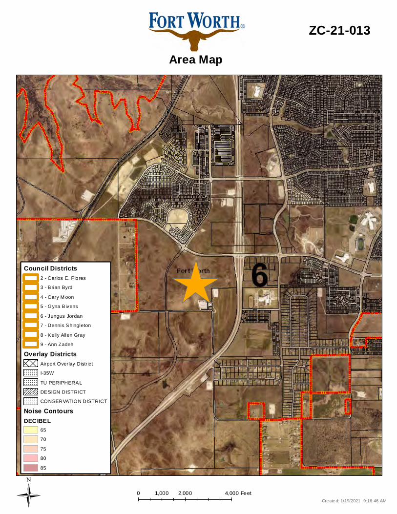
0 2,000 4,0001,000 Feet
Area Map
ZC-21-013
Created: 1/19/2021 9:16:46 AMÜ
CONSERVATION DISTRICT
Overlay DistrictsAirport Overlay DistrictI-35WTU PERIPHERALDESIGN DISTRICT
Noise ContoursDECIBEL
6570758085
Council Districts
4 - Cary M oon5 - Gyna B ivens6 - Jungus Jordan7 - Dennis Shingleton8 - Kelly Allen Gray9 - Ann Zadeh
3 - B rian Byrd2 - Carlos E. Flo res

500 0 500250 FeetA Com prehens iv e P lan shall not c ons titu te z oning r egulations ores tab l is h z oning d istrict boundaries . (Texas Loc al Governm ent Code, S ection 213.005.) Land use des ignations were approv ed by City Counci l on M arc h 6, 2018.
Future Land Use
ZC-21-013
Cr eated: 1 /19/2021 9 :16:45 AMÜ
Vacant, Undeveloped, AgriculturalRural ResidentialSuburban ResidentialSingle Family ResidentialManufactured HousingLow Density Res ident ialMedium Density ResidentialHigh Density R esident ial
InstitutionalNeighborhood CommercialGeneral CommercialLight Indus trialHeavy IndustrialMixed-UseIndustrial Growth CenterInfras truc ture100 Year Flood PlainPublic Park, Recreation, Open SpacePrivate Park, Recreat ion, Open SpaceLakes and Ponds
CMU - Commercial Mixed Use StreetNC - Neighborhood Connector
A - Ac tivity StreetCMCO - Commerc ial C onnec tor
SL - System Link
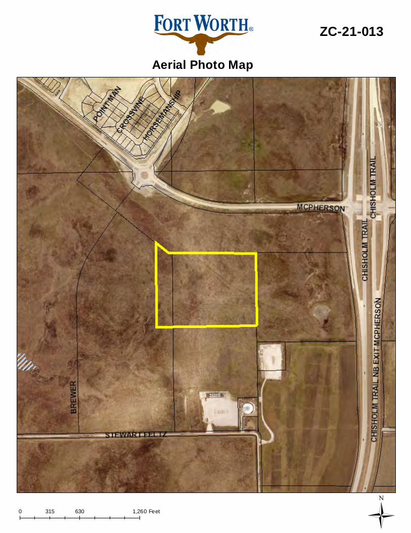
0 630 1,260315 Feet
Aerial Photo Map
ZC-21-013
Ü
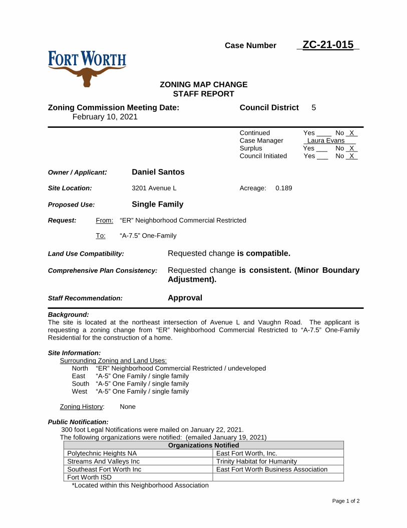
Page 1 of 2
Case Number _ZC-21-015_
ZONING MAP CHANGE STAFF REPORT
Zoning Commission Meeting Date: Council District 5 February 10, 2021
Continued Yes ____ No _X_ Case Manager _Laura Evans___ Surplus Yes ___ No _X_ Council Initiated Yes ___ No _X_
Owner / Applicant: Daniel Santos Site Location: 3201 Avenue L Acreage: 0.189 Proposed Use: Single Family Request: From: “ER” Neighborhood Commercial Restricted
To: “A-7.5” One-Family
Land Use Compatibility: Requested change is compatible. Comprehensive Plan Consistency: Requested change is consistent. (Minor Boundary
Adjustment). Staff Recommendation: Approval Background: The site is located at the northeast intersection of Avenue L and Vaughn Road. The applicant is requesting a zoning change from “ER” Neighborhood Commercial Restricted to “A-7.5” One-Family Residential for the construction of a home. Site Information:
Surrounding Zoning and Land Uses: North “ER” Neighborhood Commercial Restricted / undeveloped East “A-5” One Family / single family South “A-5” One Family / single family West “A-5” One Family / single family
Zoning History: None
Public Notification:
300 foot Legal Notifications were mailed on January 22, 2021. The following organizations were notified: (emailed January 19, 2021)
Organizations Notified Polytechnic Heights NA East Fort Worth, Inc. Streams And Valleys Inc Trinity Habitat for Humanity Southeast Fort Worth Inc East Fort Worth Business Association Fort Worth ISD
*Located within this Neighborhood Association
Page 2 of 2
Development Impact Analysis:
1. Land Use Compatibility The applicant is proposing a zoning change to “A-5” One-Family Residential. The surrounding land uses are primarily single-family residential. The properties zoned “ER” Neighborhood Commercial Restricted to the north are vacant. Future redevelopment of these properties would require additional buffering requirements due to the proximity to single-family residential.
The proposed zoning for this site is compatible at this location.
2. Comprehensive Plan Consistency – Southeast
The 2021 Comprehensive Plan designates the subject property as Neighborhood Commercial. The requested change to Single-Family is supported by following Comprehensive Plan land use policies: • Preserve the character of rural and suburban residential neighborhoods. • Promote a balance of residential, commercial, and industrial uses.
The property’s intended use as a single family residential development is consistent (Minor Boundary Adjustment) with the future land use designations of adjacent properties.
Attachments:
• Area Zoning Map with 300 ft. Notification Area • Site Plan • Area Map • Future Land Use Map • Aerial Photograph
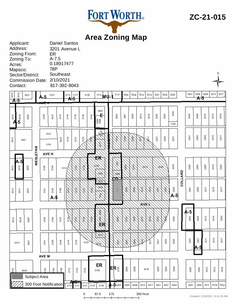
0 175 35087.5 Feet
Area Zoning Map
ZC-21-015
Applicant: Address:Zoning From:Zoning To:Acres:Mapsco:Sector/District:Commission Date:Contact:
Daniel Santos
78P0.18917477A-7.5ER3201 Avenue L
817-392-80432/10/2021Southeast
Created: 1/19/2021 9:11:26 AM
Subject Area300 Foot Notification
Ü
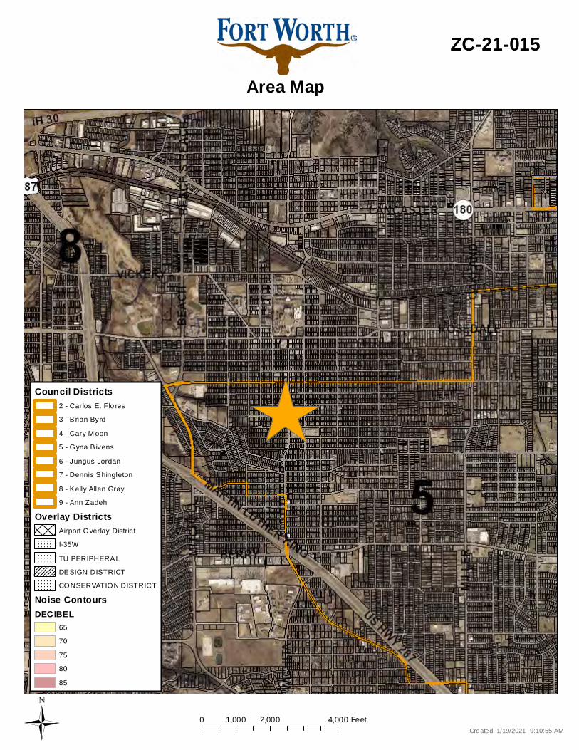
0 2,000 4,0001,000 Feet
Area Map
ZC-21-015
Created: 1/19/2021 9:10:55 AMÜ
CONSERVATION DISTRICT
Overlay DistrictsAirport Overlay DistrictI-35WTU PERIPHERALDESIGN DISTRICT
Noise ContoursDECIBEL
6570758085
Council Districts
4 - Cary M oon5 - Gyna B ivens6 - Jungus Jordan7 - Dennis Shingleton8 - Kelly Allen Gray9 - Ann Zadeh
3 - B rian Byrd2 - Carlos E. Flo res
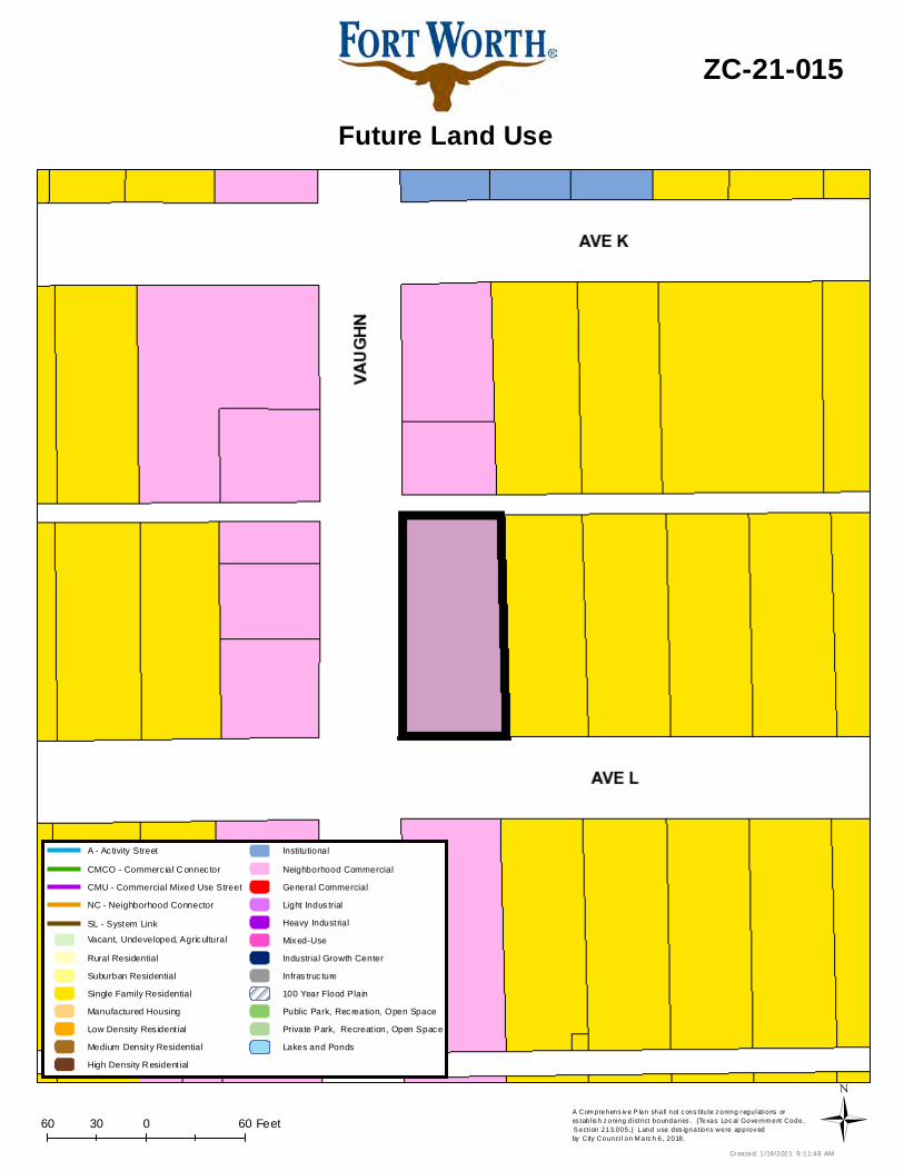
60 0 6030 FeetA Com prehens iv e P lan shall not c ons titu te z oning r egulations ores tab l is h z oning d istrict boundaries . (Texas Loc al Governm ent Code, S ection 213.005.) Land use des ignations were approv ed by City Counci l on M arc h 6, 2018.
Future Land Use
ZC-21-015
Cr eated: 1 /19/2021 9 :11:48 AMÜ
Vacant, Undeveloped, AgriculturalRural ResidentialSuburban ResidentialSingle Family ResidentialManufactured HousingLow Density Res ident ialMedium Density ResidentialHigh Density R esident ial
InstitutionalNeighborhood CommercialGeneral CommercialLight Indus trialHeavy IndustrialMixed-UseIndustrial Growth CenterInfras truc ture100 Year Flood PlainPublic Park, Recreation, Open SpacePrivate Park, Recreat ion, Open SpaceLakes and Ponds
CMU - Commercial Mixed Use StreetNC - Neighborhood Connector
A - Ac tivity StreetCMCO - Commerc ial C onnec tor
SL - System Link

0 80 16040 Feet
Aerial Photo Map
ZC-21-015
Ü