A study of the Roanoke Valley Alleghany...
47
US BICYCLE ROUTE 76 A study of the Roanoke Valley – Alleghany Region November 2017
Transcript of A study of the Roanoke Valley Alleghany...
US BICYCLE ROUTE 76 A study of the Roanoke Valley – Alleghany Region
November 2017

i
Acknowledgements This study was completed with the help of an advisory committee. The Regional Commission would like to
thank the members of this committee, listed below, for their assistance in providing feedback on the study,
as well as collecting data through car and bicycle surveys of the route.
David Holladay, Roanoke County Staff
Jim Farmer, Botetourt County Staff
Liz Belcher, Greenway Coordinator
Lindsay Webb, Roanoke County Staff
Lisa Sumpter, Botetourt County Staff
Mary Zirkel, Town of Buchanan Staff
Robert Beatty, Botetourt County Staff
Tim Miller, Greenway Commission Representative
Eddie Wells, RVARC Staff
This study is a product of the Roanoke Valley – Alleghany Regional Commission.
Project lead: Amanda McGee

ii
Contents Acknowledgements ........................................................................................................................................... i
Table of Figures ................................................................................................................................................ iv
Acronyms .......................................................................................................................................................... v
Introduction .......................................................................................................................................................... 6
Study Purpose ................................................................................................................................................... 8
Study Area ......................................................................................................................................................... 8
Physiography ............................................................................................................................................... 11
Weather and Climate .................................................................................................................................. 11
Methodology .................................................................................................................................................. 13
Field Visits ................................................................................................................................................... 13
Short Survey ................................................................................................................................................ 13
Rider Experience ......................................................................................................................................... 13
Other USBR 76 Studies .................................................................................................................................... 13
Overview of the USBR 76 Corridor ..................................................................................................................... 14
Route Description ........................................................................................................................................... 14
USBR 76 Roadway Segments ...................................................................................................................... 20
Signage ............................................................................................................................................................ 20
Land Use.......................................................................................................................................................... 20
Economic Impact ............................................................................................................................................ 24
Central Shenandoah Planning District Commission .................................................................................... 24
Adventure Cycling Organization ................................................................................................................. 24
2010 Cross State Ride ................................................................................................................................. 25
Section Inventory ................................................................................................................................................ 26
Rockbridge County to Town of Buchanan .................................................................................................. 29
Lithia Road to Town of Troutville ................................................................................................................ 30
Town of Troutville to Roanoke Cement ...................................................................................................... 31
Roanoke Cement to 311 Junction ............................................................................................................... 31
311 Junction to Montgomery County ......................................................................................................... 32
Survey Responses ............................................................................................................................................... 34
Recommendations .............................................................................................................................................. 35
Sources and Related Works ................................................................................................................................ 37
iii
Links to Restaurants and Other Amenities ..................................................................................................... 37
Appendix A: Survey and Survey Responses .......................................................................................................... A
Questions .......................................................................................................................................................... A
Answers............................................................................................................................................................. C
Appendix B: Spurs and Alternate Routes .............................................................................................................. F
Catawba Valley Road (311) (west to east) – Roanoke County, Salem, City of Roanoke ................................... F
Blue Ridge Parkway from Downtown Roanoke to Town of Buchanan (west to east) ...................................... F
US 11/460 (west to east) – Christiansburg to Roanoke Valley ......................................................................... F
Appendix C: VDOT Roadway Functional Classification System ............................................................................ G
Rural Functional Classification System ............................................................................................................ G
Rural principal arterial ................................................................................................................................. G
Rural major collector ................................................................................................................................... G
Rural local .................................................................................................................................................... G
Urban Functional Classification System ........................................................................................................... G
Urban principal arterial ................................................................................................................................ G
Urban minor arterial .................................................................................................................................... H
Urban local ................................................................................................................................................... H

iv
Table of Figures
Table 1: Census Geographies ................................................................................................................................ 8
Table 2: Locally Identified Places .......................................................................................................................... 9
Table 3: Average Temperature and Precipitation - Roanoke Virginia ................................................................ 12
Table 4: USBR 76 Cue Sheet - Botetourt and Roanoke Counties ........................................................................ 15
Table 5: USBR 76 Study Area Roadways, VDOT .................................................................................................. 18
Table 6: USBR 76 Average Annual Daily Traffic (AADT), VDOT ........................................................................... 19
Table 7: Historical Markers, VDOT ...................................................................................................................... 28
Table 8: Additional Historic Resources, VDHR .................................................................................................... 28
Figure 1: USBR 1 and 76, Virginia Department of Transportation (VDOT) ........................................................... 6
Figure 2: USBR 76 Sign, VDOT ............................................................................................................................... 6
Figure 3: National Corridor Plan, Adventure Cycling Organization....................................................................... 7
Figure 4: Study Area - Roanoke Valley ................................................................................................................ 10
Figure 5: Geologic and Physiographic Provinces of Virginia, James Madison University ................................... 11
Figure 6: Roanoke Climograph, US Climate Data ................................................................................................ 12
Figure 7: USBR 76 in Botetourt and Roanoke County ......................................................................................... 16
Figure 8: USBR 76 Elevation Profile - Botetourt and Roanoke Counties ............................................................ 17
Figure 9: Signage on the Corridor ....................................................................................................................... 21
Figure 10: Roanoke County Future Land Use Map ............................................................................................. 22
Figure 11: Botetourt County Future Land Use Map............................................................................................ 23
Figure 12: Historical Markers, VDHR, VDOT ....................................................................................................... 27

v
Acronyms
AADT - Average Annual Daily Traffic
AASHTO – American Association of State Highway and Transportation Officials
AT - Appalachian Trail
B&B - Bed & Breakfast
CDP – Census Designated Place
NPS - National Park Service
RSTP - Regional Surface Transportation Program
RVAMPO - Roanoke Valley Area Metropolitan Planning Organization
RVARC - Roanoke Valley Alleghany Regional Commission
RVTPO – Roanoke Valley Transportation Planning Organization
TA - Transportation Alternatives
UA - Urbanized Area
UC – Urban Cluster
USBRS - United States Bicycle Route System
USFS - United States Forest Service
VDOT - Virginia Department of Transportation
VDHR – Virginia Department of Historical Resources

6
Introduction Established in 1978 by the American Association of State Highway and Transportation Officials (AASHTO), the
United States Bicycle Route System (USBRS) is a network of long-distance cycling routes in the United States
(Figure 3). The purpose of the USBRS is to facilitate bicycle travel on appropriate roads, paths and highways
over routes that are desirable for interstate bicyclists. A route is formed as a continuous network of available
roads through two or more states connecting and traversing areas of scenic, cultural, and recreational
interest.
US Bicycle Route 76, along with USBR 1, is one of the two original USBRS routes officially designated in 1982.
Also known as the TransAmerica Trail (and formerly the Bikecentennial), USBR 76 is an east-west oriented,
cross-country bicycle route running for approximately 4,250 miles from Yorktown, Virginia to Astoria,
Oregon. Approximately 500 miles of USBR 76 are located in Virginia between Yorktown in the east and the
Kentucky state line near Breaks Interstate Park in the west (Figure 1). In Virginia, USBR 76 is demarcated with
rectangular, black and white, signs with a bicycle image, route number, and directions arrow.
Figure 2: USBR 76 Sign, VDOT
Figure 1: USBR 1 and 76, Virginia Department of Transportation (VDOT)

7 | P a g e
Figure 3: National Corridor Plan, Adventure Cycling Organization
8 | P a g e
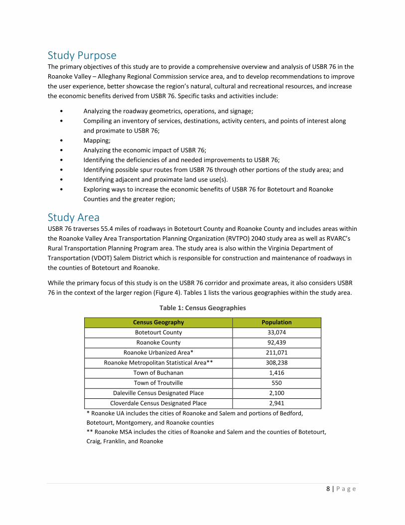
Study Purpose The primary objectives of this study are to provide a comprehensive overview and analysis of USBR 76 in the
Roanoke Valley – Alleghany Regional Commission service area, and to develop recommendations to improve
the user experience, better showcase the region’s natural, cultural and recreational resources, and increase
the economic benefits derived from USBR 76. Specific tasks and activities include:
• Analyzing the roadway geometrics, operations, and signage;
• Compiling an inventory of services, destinations, activity centers, and points of interest along
and proximate to USBR 76;
• Mapping;
• Analyzing the economic impact of USBR 76;
• Identifying the deficiencies of and needed improvements to USBR 76;
• Identifying possible spur routes from USBR 76 through other portions of the study area; and
• Identifying adjacent and proximate land use use(s).
• Exploring ways to increase the economic benefits of USBR 76 for Botetourt and Roanoke
Counties and the greater region;
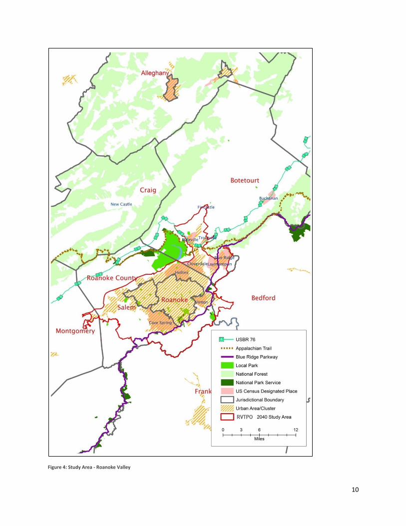
Study Area USBR 76 traverses 55.4 miles of roadways in Botetourt County and Roanoke County and includes areas within
the Roanoke Valley Area Transportation Planning Organization (RVTPO) 2040 study area as well as RVARC’s
Rural Transportation Planning Program area. The study area is also within the Virginia Department of
Transportation (VDOT) Salem District which is responsible for construction and maintenance of roadways in
the counties of Botetourt and Roanoke.
While the primary focus of this study is on the USBR 76 corridor and proximate areas, it also considers USBR
76 in the context of the larger region (Figure 4). Tables 1 lists the various geographies within the study area.
Table 1: Census Geographies
Census Geography Population
Botetourt County 33,074
Roanoke County 92,439
Roanoke Urbanized Area* 211,071
Roanoke Metropolitan Statistical Area** 308,238
Town of Buchanan 1,416
Town of Troutville 550
Daleville Census Designated Place 2,100
Cloverdale Census Designated Place 2,941
* Roanoke UA includes the cities of Roanoke and Salem and portions of Bedford,
Botetourt, Montgomery, and Roanoke counties
** Roanoke MSA includes the cities of Roanoke and Salem and the counties of Botetourt,
Craig, Franklin, and Roanoke
9
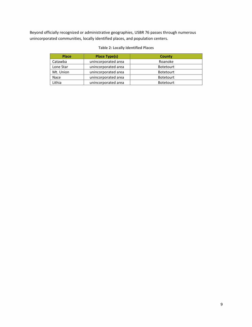
Beyond officially recognized or administrative geographies, USBR 76 passes through numerous
unincorporated communities, locally identified places, and population centers.
Table 2: Locally Identified Places
Place Place Type(s) County
Catawba unincorporated area Roanoke
Lone Star unincorporated area Botetourt
Mt. Union unincorporated area Botetourt Nace unincorporated area Botetourt Lithia unincorporated area Botetourt
10
Figure 4: Study Area - Roanoke Valley

11
Physiography USBR 76 traverses the Valley and Ridge and the Blue Ridge physiographic/geologic provinces of Virginia
(Figure 5). The Valley and Ridge physiographic/geologic province is characterized by sedimentary rocks folded
and faulted in anticlines (ridges) and synclines (valleys) and a trellis drainage pattern with streams running
parallel to long ridges. USBR 76 passes through both the Roanoke River and James River watersheds crossing
the divide several times along the route and paralleling or crossing Catawba Creek, Tinker Creek, the James
River, and a number of smaller streams.
Weather and Climate The study area climate can be generally characterized as humid-subtropical (Cfa) to humid continental –
warm summer (Dfa) with considerable variation based on elevation. Both climate types are characterized by
seasonal variation in temperature and precipitation distributed throughout the year. Table 3 and Figure 6
provide average temperatures and precipitations for the study area.
Figure 5: Geologic and Physiographic Provinces of Virginia, James Madison University

12
Table 3: Average Temperature and Precipitation - Roanoke Virginia
January February March April May June
Average high in °F 46 49 58 68 76 83
Average low in °F: 28 30 37 45 53 62
Average precipitation in inch 2.91 2.87 3.46 3.39 4.06 3.82
Average snowfall in inch 6 6 2 1 0 0
July August September October November December
Average high in °F 87 86 78 69 59 48
Average low in °F 66 65 58 47 38 30
Average precipitation in inch 4.06 3.54 3.9 2.87 3.39 2.95
Average snowfall in inch 0 0 0 0 1 4
Figure 6: Roanoke Climograph, US Climate Data

13
Methodology In order to collect the data needed to complete this study, the following methods were used.
Field Visits Locality staff and RVARC staff took two driving tours of the route. One driving tour encompassed the parts of
the route located within Roanoke County, and was led by Roanoke County staff. The second driving tour was
led by Botetourt County and Town of Buchanan staff, and took place on the sections located within Botetourt
County. The goal of these tours was to locate signage which may not have been included in the VDOT
shapefiles (dated 2009) and to identify potential amenities or points of interest along the route.
Short Survey RVARC staff created a brief, 5-question online survey to distribute to area bicyclists regarding their
experiences on USBR 76 within the study area. This survey divided the route into sections, listed in the
Section Analysis. The results of the survey as well as the original survey questions are included in Appendix C.
Rider Experience Tim Miller, a local cyclist and member of the Roanoke Valley Greenway Commission, biked this route with an
eye to navigation issues and hazards which might present themselves to cyclists, including road surface,
safety, and other issues. His experience informed the Section Analysis.
Other USBR 76 Studies In Virginia, there have been other studies conducted by planning district commissions (PDC) which may be
relevant to readers of this study. These are the corridor studies undertaken by the Thomas Jefferson PDC and
the New River Valley PDC. References to both of these studies are available in the Sources and Related Works
section at the end of this document.
The New River Valley’s corridor study is of particular impact on this document as that PDC borders the
Regional Commission study area. The NRVPDC service boundary begins at the Montgomery County line and
continues along the USBRS 76 corridor from there.

14
Overview of the USBR 76 Corridor This section provides a comprehensive overview of USBR 76 in the study area including route description,
roadway geometrics and operations, and related information. Information was collected using fieldwork, GIS,
stakeholder input, and secondary data sources. Route analysis includes the following items:
• route segments
• elevation profile
• directions / cue sheets
• roadway classification speed limit
• annual average daily traffic
• travel lane pavement width
• shoulder type, width, and condition
• pavement condition
• signage
• maintenance issues
• hazards or safety concerns
• adjacent or proximate activity centers or points of interest
The Virginia Department of Transportation is responsible for construction and maintenance on all public
roadways, including USBR 76 designed segments, in Botetourt and Roanoke counties.
Route Description USBR 76 runs for 55.4 miles through Botetourt and Roanoke Counties, entering/exiting Botetourt County
from Rockbridge County in the east and entering/exiting Roanoke County from Montgomery County in the
west (Figure 7). Of this distance, 13.7 miles are located in Roanoke County and 40 miles are in Botetourt
County. Figure 8 provides an elevation profile, with reference points along USBR 76, in the study area. Table 4
provides detailed, turn-by-turn USBR 76 route directions (cue sheet) for both east-to-west and west-to-east
travel.
The route topography in the study area is generally rolling, interspersed with moderately difficult
climbs/descents. Elevation along the route ranges from approximately 2,000 feet to 900 feet, with the
highest elevation (approximately 1,977 feet) at the Roanoke River/James River drainage divide on Blacksburg
Road (785) in eastern Roanoke County and the lowest point (approximately 900 feet) at the James River in
the Town of Buchanan (Figure 8).

15
Table 4: USBR 76 Cue Sheet - Botetourt and Roanoke Counties
East to West Travel Direction Total
Distance (miles) Direction Roadway
Distance to Next Maneuver (miles)
0 Straight Lee Highway (US 11) – enter Botetourt Co from Rockbridge Co 3.5
3.5 Right Overpass Road (623) crossing 1-81 0.1
3.6 Left Frontage Road 54 4.0
7.6 Left Lee Highway (US 11)/Main Street through Town of Buchanan 3.9
11.5 Left Lithia Road (640) 6.3
17.8 Left Nace Road (640) 3.9
21.7 Left Lee Highway (US 11) 0.6
22.3 Left Stoney Battery Road 3.4
25.7 Left Lee Highway (US 11) 1.1
26.8 Right Valley Road (779) 1.6
28.4 Right US 220 (Roanoke Road) 0.2
28.6 Left Catawba Road (779) 13.2
41.8 Straight Catawba Creek Road (779) – enter Roanoke Co from Botetourt Co 3.6
45.4 Right Catawba Valley Road (311) 0.5
45.9 Left Blacksburg Road (785) 9.6
55.5 Straight Blacksburg Road (785) – enter Montgomery Co from Roanoke Co
West to East Travel Direction Total
Distance (miles) Direction Roadway
Distance to Next Maneuver (miles)
0 Straight Blacksburg Road (785) – enter Roanoke Co from Montgomery Co 9.6
9.6 Right Catawba Valley Road (311) 0.5
10.1 Left Catawba Creek (779) – enter Botetourt Co from Roanoke Co 3.6
13.7 Straight Catawba Road (779) 13.2
26.9 Right US 220 (Roanoke Road) 0.2
27.1 Left Valley Road (779) 1.6
28.7 Left Lee Highway (US 11) 1.1
29.8 Right Stoney Battery Road 3.4
33.2 Right Lee Highway (US 11) 0.6
33.8 Right Nace Road (640) 3.9
37.7 Right Lithia Road (640) 6.3
44.0 Right Lee Highway (US 11)/Main Street through Town of Buchanan 3.9
47.9 Right Frontage Road 54 4.0
51.9 Right Overpass Road (623) crossing 1-81 0.1
52.0 Left Lee Highway/Frontage Road 55 3.5
55.5 Straight Lee Hwy (US 11)/FR 55– enter Rockbridge Co from Botetourt Co

16
Figure 7: USBR 76 in Botetourt and Roanoke County

17
Dalevile
(US 220)
Elevation: 1000 ft
Botetourt / Roanoke
County Corporate Limits
(Route 779)
Elevation: 1785 ft
Roanoke River/ James
River Watershed Divide
(Route 785)
Elevation: 1977 ft
Town of Troutville
(US 11/Lee Highway)
Elevation: 1000 ft Town of Buchanan
(US 11/Lee Highway)
Elevation: 1000 ft
James River
Elevation: 900 ft
Botetourt / Roanoke
County Corporate Limits
(US 11/Lee Highway)
Elevation: 1000 ft
Appalachian Trail Crossing
(US 11/Lee Highway)
Elevation: 1000 ft
Catawba
Elevation: 1739
ft
Catawba
Elevation: 1739
ft
Figure 8: USBR 76 Elevation Profile - Botetourt and Roanoke Counties

18
Table 5: USBR 76 Study Area Roadways, VDOT
ROADWAY SEGMENT NAME FROM TO LOCALITY VDOT CLASSIFICATION
SPEED LIMIT
LENGTH (MILES)
BLACKSBURG (ROUTE 785) CORPORATE LIMIT CATAWBA VALLEY (ROUTE 311) ROANOKE COUNTY RURAL MAJOR COLLECTOR
55 9.6
CATAWBA VALLEY (ROUTE 311) BLACKSBURG (ROUTE 785) CATAWBA CREEK (ROUTE 779) ROANOKE COUNTY RURAL MAJOR COLLECTOR
55 0.5
CATAWBA CREEK (ROUTE 779) CATAWBA VALLEY (ROUTE 311) CORPORATE LIMIT ROANOKE COUNTY RURAL MAJOR/MINOR COLLECTOR
55 3.6
ROANOKE COUNTY MILES 13.7
CATAWBA CORPORATE LIMIT MPO STUDY AREA BOUNDARY (BLACKSBURG)
BOTETOURT COUNTY RURAL MAJOR/MINOR COLLECTOR
55 8.5
CATAWBA MPO STUDY AREA BOUNDARY (BLACKSBURG RD)
US 220 (ROANOKE) BOTETOURT COUNTY URBAN COLLECTOR 55 4.6
US 220 (ROANOKE) CATAWBA (ROUTE 779) VALLEY BOTETOURT COUNTY URBAN PRINCIPAL ARTERIAL
45 0.2
VALLEY (779) US 220 (ROANOKE) LEE HIGHWAY (US 11) BOTETOURT COUNTY URBAN COLLECTOR 35 1.6
US 11 (LEE HIGHWAY) VALLEY STONEY BATTERY BOTETOURT COUNTY URBAN PRINCIPAL ARTERIAL
40/35 1.1
STONEY BATTERY LEE HIGHWAY (US 11) LEE HIGHWAY (US 11) BOTETOURT COUNTY LOCAL NON-CLASSIFIED
30/25 3.4
US 11 (LEE HIGHWAY) STONEY BATTERY NACE BOTETOURT COUNTY RURAL MAJOR COLLECTOR
55 0.6
NACE (640) LEE HIGHWAY (US 11) LITHIA BOTETOURT COUNTY LOCAL NON-CLASSIFIED
40/35 3.9
LITHIA (640) NACE (640) LEE HIGHWAY (MAIN) BOTETOURT COUNTY LOCAL NON-CLASSIFIED
40/35 6.3
LEE HIGHWAY (MAIN) LITHIA FRONTAGE ROAD 54 (1-81) BOTETOURT COUNTY RURAL MAJOR COLLECTOR
55/35/25
3.9
FRONTAGE ROAD 54 (1-81) LEE HIGHWAY (MAIN) OVERPASS (623) BOTETOURT COUNTY LOCAL NON-CLASSIFIED
35 4.0
OVERPASS (623) FRONTAGE ROAD 54 (1-81) US 11 (LEE HIGHWAY) BOTETOURT COUNTY LOCAL NON-CLASSIFIED
35 0.1
US 11 (LEE HIGHWAY) OVERPASS (623) CORPORATE LIMIT BOTETOURT COUNTY RURAL MAJOR COLLECTOR
55 3.5
BOTETOURT COUNTY MILES 41.7
STUDY AREA TOTAL MILES 55.4

19
Route
Number Route Name Locality
Segment
Length Segment Start Segment End AADT
Percent 2
and 4 Tire
Vehicles
Percent
Busses
Percent
Single Unit
Trucks 2
Axle
Percent
Single Unit
Trucks 3+
Axle
Percent
Combination
Trucks 1
Trailer
Percent
Combination
Trucks 2+
Trailer
00785 Blacksburg Rd Roanoke County 2.18 Montgomery County Line 80-697 Sandyridge Rd 310 98% 0% 1% 0% 0% 0%
00785 Blacksburg Rd Roanoke County 7.55 80-697 Sandyridge Rd SR 311 Catawba Valley Dr 350 98% 0% 1% 0% 0% 0%
00779 Catawba Creek Rd Roanoke County 0.75 SR 311 Catawba Valley Dr; 80-698 Keffer Rd SR 320 Catawba Hospital Dr 800 No Data No Data No Data No Data No Data No Data
00779 Catawba Creek Rd Roanoke County 1.56 SR 320 Catawba Hospital Dr 80-600 Moses Family Rd 640 No Data No Data No Data No Data No Data No Data
00779 Catawba Creek Rd Roanoke County 1.32 80-600 Moses Family Rd Botetourt County Line 240 No Data No Data No Data No Data No Data No Data
00311 Catawba Valley Dr Roanoke County 6.70 SR 419 Electric Rd 80-779 Catawba Creek Rd 9100 97% 0% 1% 1% 1% 0%
00311 Catawba Valley Dr Roanoke County 0.52 80-779 Catawba Creek Rd 80-785 Blacksburg Rd 4800 96% 0% 1% 1% 1% 0%
00311 Catawba Valley Dr Roanoke County 2.54 80-785 Blacksburg Rd Craig County Line 4500 96% 0% 1% 1% 1% 0%
00779 Catawba Rd Botetourt County 4.62 Roanoke County Line 11-600 S, Little Catawba Creek Rd 230 No Data No Data No Data No Data No Data No Data
00779 Catawba Rd Botetourt County 1.31 11-600 S, Little Catawba Creek Rd 11-600 N, Haymakertown Rd 690 No Data No Data No Data No Data No Data No Data
00779 Catawba Rd Botetourt County 1.43 11-600 N, Haymakertown Rd 11-664 Asbury Lane 800 No Data No Data No Data No Data No Data No Data
00779 Catawba Rd Botetourt County 0.72 11-664 Asbury Lane 11-666 Haymakertown Rd 1500 100% 0% 0% 0% 0% 0%
00779 Catawba Rd Botetourt County 0.33 11-666 Haymakertown Rd 11-630 Blacksburg Rd 2300 90% 1% 1% 1% 8% 0%
00779 Catawba Rd Botetourt County 2.89 11-630 Blacksburg Rd 11-672 E, Etzler Rd 5300 87% 1% 1% 1% 9% 0%
00779 Catawba Rd Botetourt County 0.46 11-672 E, Etzler Rd 11-675 Glebe Rd 4200 100% 0% 0% 0% 0% 0%
00779 Catawba Rd Botetourt County 0.80 11-675 Glebe Rd 11-626 Mimosa St 4700 100% 0% 0% 0% 0% 0%
00779 Catawba St Botetourt County 0.55 11-626 Mimosa St US 220 N, Roanoke Rd 5800 100% 0% 0% 0% 0% 0%
00779 Valley Rd Botetourt County 1.46 US 220 S, Roanoke Rd WCL Troutvil le 1400 100% 0% 0% 0% 0% 0%
00779 Valley Rd Town of Troutvil le 0.15 WCL Troutvil le US 11 Lee Highway 1500 100% 0% 0% 0% 0% 0%
00011 Lee Highway Botetourt County 0.10 Roanoke County Line 80-601 Shadwell Dr 17000 93% 1% 1% 1% 4% 0%
00011 Lee Highway Botetourt County 2.73 80-601 Shadwell Dr ALT SR 220 Cloverdale Rd 12000 90% 1% 1% 2% 6% 0%
00011 Lee Highway Botetourt County 0.25 ALT SR 220 Cloverdale Rd Ramp From I-81 NB at Exit 150 B 6800 99% 0% 0% 0% 0% 0%
00011 Lee Highway Botetourt County 1.09 Ramp From I-81 NB at Exit 150 B SCL Troutvil le 6800 99% 0% 0% 0% 0% 0%
00011 Lee Highway Town of Troutvil le 1.85 SCL Troutvil le NCL Troutvil le 6800 99% 0% 0% 0% 0% 0%
00011 Lee Highway Botetourt County 2.98 NCL Troutvil le 11-640 Brughs Mill Rd 4900 95% 1% 1% 1% 1% 0%
00011 Lee Highway Botetourt County 5.86 11-640 Brughs Mill Rd I-81 South of Buchanan 3100 95% 1% 1% 1% 1% 0%
00011 Lee Highway Botetourt County 2.23 I-81 South of Buchanan WCL Buchanan 4100 95% 1% 1% 1% 2% 0%
00011 Main St Town of Buchanan 0.43 WCL Buchanan 11-625 Mt Joy Rd 4100 95% 1% 1% 1% 2% 0%
00011 Main St Town of Buchanan 2.09 11-625 Mt Jay Rd SR 43 Parkway Dr 4000 95% 1% 1% 1% 2% 0%
00011 Main St Town of Buchanan 0.18 SR 43 Parkway Dr SR 43 First St 4100 95% 2% 2% 0% 1% 0%
00011 Main St Town of Buchanan 0.78 SR 43 First St NCL Buchanan 2800 95% 1% 1% 1% 2% 0%
00011 Lee Highway Botetourt County 0.35 NCL Buchanan I-81 North of Buchanan 2800 95% 1% 1% 1% 2% 0%
00651 Stoney Battery Rd Town of Troutvil le 0.10 US 11 MID, Lee Highway 11-716 Apple Orchard Lane 1400 No Data No Data No Data No Data No Data No Data
00651 Stoney Battery Rd Town of Troutvil le 0.33 11-716 Apple Orchard Lane ECL Troutvil le 410 No Data No Data No Data No Data No Data No Data
00651 Stoney Battery Rd Botetourt County 3.05 ECL Troutvil le US 11 N, Lee Highway 460 No Data No Data No Data No Data No Data No Data
00640 Nace Rd Botetourt County 0.90 US 11 S, Lee Highway 11-711 Houston Mines Rd 1100 No Data No Data No Data No Data No Data No Data
00640 Nace Rd Botetourt County 3.05 11-711 Houston Mines Rd 11-606 E, Blue Ridge Trpk 620 No Data No Data No Data No Data No Data No Data
00640 Lithia Rd Botetourt County 3.46 11-606 E, Blue Ridge Trpk 11-636 Hardbarger Rd 260 No Data No Data No Data No Data No Data No Data
00640 Lithia Rd Botetourt County 2.89 11-636 Hardbarger Rd US 11 N, Lee Highway 340 No Data No Data No Data No Data No Data No Data
00623 Overpass Rd Botetourt County 0.08 FR-55 Lee Highway FR-54 Frontage Rd 380 No Data No Data No Data No Data No Data No Data
00054 Purgatory Mountain Rd Botetourt County 1.24 Dead End I-81 Interchange 230 No Data No Data No Data No Data No Data No Data
00054 Frontage Rd Botetourt County 0.84 I-81 Interchange 11-614 Arcadia Rd 650 No Data No Data No Data No Data No Data No Data
00054 Frontage Rd Botetourt County 1.58 11-614 Arcadia Rd 11-608 Indian Rock Rd 1100 No Data No Data No Data No Data No Data No Data
00054 Frontage Rd Botetourt County 2.08 11-608 Indian Rock Rd 11-622 Alpine Rd 2400 No Data No Data No Data No Data No Data No Data
00054 Frontage Rd Botetourt County 0.85 11-622 Alpine Rd Dead End 180 No Data No Data No Data No Data No Data No Data
Table 6: USBR 76 Average Annual Daily Traffic (AADT), VDOT

20
USBR 76 Roadway Segments USBR 76 utilizes 16 separate roadway segments in the study area with the majority being classified as Rural
Major Collectors by VDOT. Speeds limits range from 25 MPH to 55 MPH with the highest speed limits
generally occurring in Roanoke County on Blacksburg Road, Catawba Valley Drive (Route 311), and Catawba
Creek Road. The highest speed limits in Botetourt County occur on Catawba Road and US Route 11 (Lee
Highway). Table 5 shows more information about the roadways within the study area.
In Roanoke County, average annual daily traffic (AADT) ranges from a high of 4,800 along Catawba Valley
Drive (311) to a low of 240 on Catawba Creek Road (779). In Botetourt County, the high is 5,800 on Catawba
Street, and the low is 230 on Catawba Road. These numbers show a great deal of traffic variation throughout
the route, depending on the roadway in question. High traffic volume is centered around denser
development patterns and major highways such as U.S. 220, S.R. 311, and U.S. 11.
Signage Wayfinding signage is an important element of navigating any on-road route. USBR 76 users should be able to
easily follow the route in either direction without becoming lost. Key points for signage include turns and
junctions. Signage is maintained by VDOT as part of their general maintenance operations within road right-
of-way.
Figure 9 contains the sign map which was created with the help of VDOT and the locality staff of Roanoke
County, Botetourt County, and the Town of Buchanan. It shows a well-signed corridor. Survey of the corridor
showed only one significant hazard with respect to signage. This was at the 311 junction. More on this issue
will be discussed in the Section Analysis.
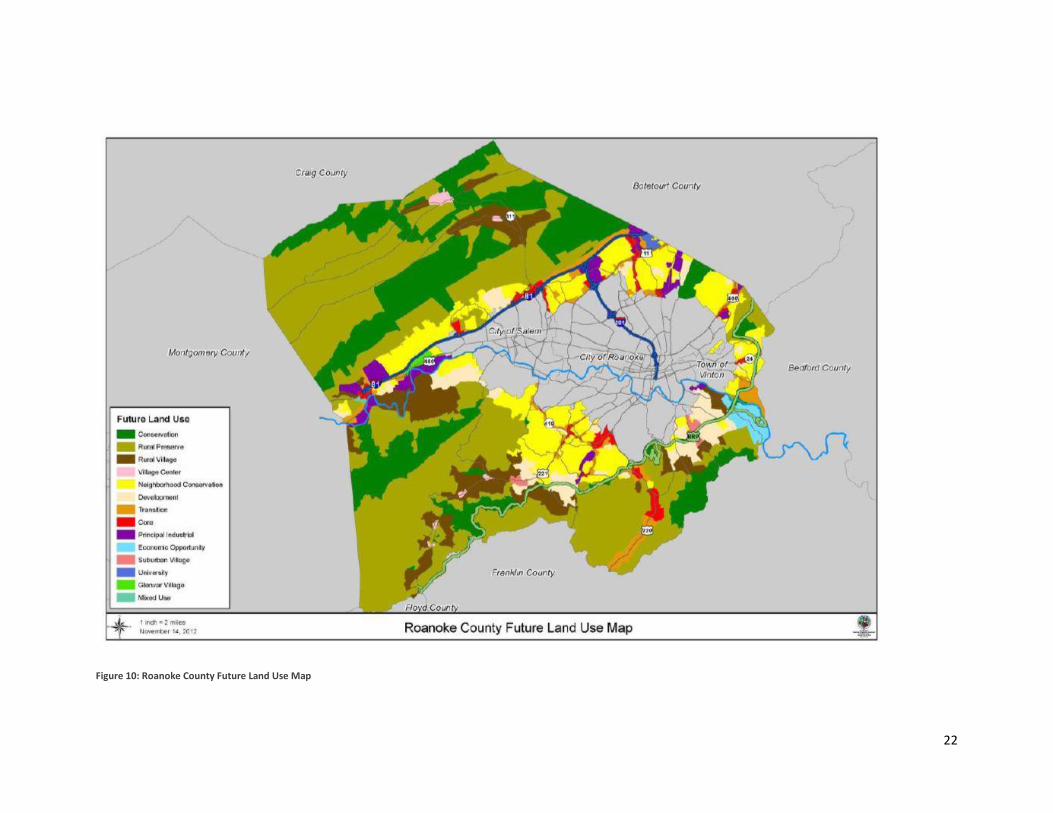
Land Use Land use along the corridor is broadly characterized by rural farmland, with the exception of key locations
such as Troutville, Buchanan, and Daleville. Figures 10 and 11 contain the future land use maps for Roanoke
County and Botetourt County, respectively.
The pink area in northern Roanoke County corresponds to the Catawba Community Center and Catawba Post
Office locations. This color denotes a village center. The rest of the route contained within Roanoke County is
conservation or other rural use.
In Botetourt, much of the route is also located in rural, low-density use areas. However, Daleville in particular
may present issues in the future for this corridor, since the land use in this area is particularly dense, being
part of the Roanoke MPO boundary. Daleville is located within the large, orange section in the Botetourt
County future land use map which denotes medium density residential and commercial development in this
area.

21
Figure 9: Signage on the Corridor
22
Figure 10: Roanoke County Future Land Use Map

23
Figure 11: Botetourt County Future Land Use Map

24
Economic Impact Currently, USBR 76 largely bypasses population centers in the Roanoke Valley. This is likely by design.
Bypassing major population centers puts cyclists on rural road, which improves their safety and experience
by allowing for lower traffic volume and scenic views. This, however, somewhat limits the potential for
economic impact on the Roanoke Valley. Attempts at quantifying the direct and indirect economic impacts
of USBR 76 encounter therefore face several challenges, including lack of empirical data. While USBR 76
showcases the study area’s scenic beauty and natural resources, direct, tangible economic benefits (sales tax,
employment, visitor spending) from the route are limited, especially in Roanoke County.
One way of increasing economic impact of USBR 76 is to encourage spur and loop routes off of the main bike
route. If destination traveler on looped routes were encouraged, the economic impact could increase. When
cyclists find an event that extends their stay, such as the Damascus Trail Days, economic impact also
increases. Hotels represent the largest daily expenditure for USBR 76 through-cyclists, based on available
data.
Central Shenandoah Planning District Commission The Central Shenandoah Planning District Commission (CSPDC) conducted a study in 2015 regarding the
economic impact of bicyclists in their region. As they are neighbors to the Roanoke Valley – Alleghany Region,
these numbers are perhaps the most relevant to this study.
The report, entitled The Economic Impact of Bicycling in the Central Shenandoah Valley, was published in
August of 2016. In the Executive Summary, CSPDC cites that 71 percent of cyclists visiting the Central
Shenandoah region stayed at least one night in the area, with average daily spending, including food, lodging,
and other spending, being $155 per person. CSPDC estimates that direct economic impact for the region is
$8.6 million, while indirect impact is $13.6 million. This number includes all bicycle tourism in the area, and
may not be limited to on-road routes.
Adventure Cycling Organization Regional Commission staff contacted the Adventure Cycling Organization to obtain information on USBR 76
use and expenditures. Based on a combination of USBR 76 map sales and the number of cyclists that visited
the Adventure Cycling headquarters, the organization estimated a total of 1,200 USBR 76 through-cyclists
annually.
Adventure Cycling Organization has also developed a compilation of reports and studies analyzing economic
impact of bicycle routes and systems throughout the US and abroad. Based on review of the following
studies, average daily (overnight) expenditure for USBR 76 through cyclists in the study area is estimated to
be approximately $100 per person. Given the length of USBR in the study area it is estimated that through
cyclists average one overnight stay, with Daleville or Buchanan being the most likely overnight locations. This
is based off of evaluations from the two reports below.
Great Allegheny Passage (GAP) A 2012 study of the Great Allegheny Passage shows that trail users spend an average of $114 for overnight
stays. Businesses along the trail attributed thirty percent of their gross revenues to the GAP, and about half
of the businesses said that the trail affected their decision to expand.

25
Montana The Institute for Tourism and Recreation Research (ITRR) at the University of Montana’s School of Forestry
conducted a study entitled, "Analysis of Touring Cyclists: Impacts, Needs and Opportunities for
Montana,"which found that multi-day cyclists spend $75 per day while in Montana, and stay an average of
eight or more nights. Researchers queried cyclists who had visited Adventure Cycling headquarters in 2013,
or who had purchased Montana section maps between 2010-2013. Cyclists hailed from 48 states and 18
countries.
2010 Cross State Ride The annual economic impact observed during the 2010 Cross State Ride is estimated at $200,000. This is
based on estimates provided by the Joseph Morgan at the Virginia Bicycle Federation (VBF). The VBF met
with about 80 cross state riders during their two-week journey, or an average 40 per week. With an average
of 40 through travelers spending approximately $250 per week for food, lodging and other expenses, weekly
spending equals $10,000. Based on this observation, the estimated impact of 40 through cyclists per week
over a 20 week optimum travel season yields an annual impact of $200,000. Overall, USBR 76 is comparable
in economic impact to a major club sponsored day or weekend bicycle ride.
VBF hopes to get a more reliable rider count by putting a log in point at a location that all USBR 76 riders are
likely to pass, such as the Draper Mercantile in Pulaski County.

26
Section Inventory The following portion of this study will break the route into sub-sections for easier discussion of amenities
and issues observed upon the route. The items listed for each sub-section have been determined by public
survey and interviews with locality staff, as well as by riding the route either by car or bicycle. The hazards,
points of interest, and amenities will be listed in order of encounter if riding the route from north to south
under their respective headings. Links to more information about these listed locations can be found in
Sources and Related Works section of this document.
Figure 12, below, shows historical markers, which will be discussed as points of interest in this section. Tables
7 and 8 further demonstrate historic sites within Botetourt and Roanoke County.
Special thanks for assistance on gathering information for this section must go to Tim Miller and locality staff.

27
Figure 12: Historical Markers, VDHR, VDOT

28
Table 7: Historical Markers, VDOT
Table 8: Additional Historic Resources, VDHR
Historic Resource Locality Historic Register
Catawba Furnace Botetourt Virginia Landmarks Register
Anderson-Doosing-McDonald House (Doosing-McNeil Farm) Roanoke Virginia Landmarks Register / National Register
Johnsville Old German Baptist Meetinghouse Roanoke Virginia Landmarks Register / National Register
Wilson Warehouse Botetourt-Buchanan Virginia Landmarks Register / National Register
Looney Mill Creek Site Botetourt Virginia Landmarks Register / National Register
Thomas D. Kinzie House Botetourt Virginia Landmarks Register / National Register
Nininger’s Mill Botetourt Botetourt Comprehensive Plan
Buchanan Historic District Botetourt-Buchanan Virginia Landmarks Register / National Register
29
Rockbridge County to Town of Buchanan The study area begins at the border of Rockbridge County and Botetourt County. This section of the study
area begins at Route 11, moves onto Overpass Road, continues onto Frontage Road into the Town of
Buchanan, and then continues down Route 11 until the turn onto Lithia Road just past the Town of
Buchanan’s southern edge. The length of this section is approximately 10 miles.
Hazards Hazards of note on this section are limited. Per Tim Miller, the two elements of note on this section are the
increased road noise, and an increase in traffic in the last mile before the turn onto Lithia Road. The
increased road noise in this section is a product of paralleling Interstate 81.
Points of Interest There are several VDOT historical markers on this stretch of the route. Many of the historical markers are
localized within the Town of Buchanan.
• Number 15: Audley Paul’s Fort
• Number 14: Cartsmill Gap
• Number 13: Buchanan
• Number 3: Looney’s Ferry
In addition there are VDHR recognized historic resource, Wilson Warehouse, now the Buchanan Community
House, and the Looney Mill Creek Site.
Amenities Key amenities for this stretch are centered within the Town of Buchanan. In addition to three restaurants,
several small convenience and dollar stores, and bed and breakfasts, the town contains the below amenities.
Buchanan Post Office The Buchanan Post Office provides a place to conduct mail pickup on long-distance trips.
Buchanan Library The Buchanan Library has free wifi to allow cyclists to connect to the internet.
Twin River Outfitters Twin River Outfitters primarily provides rentals of river adventure equipment with which to experience the
James River Water Trail. They also own and operate the James River House, an establishment which offers
both private rooms and bunks.
Town Park The town park offers seasonally open public restrooms, as well as camping for the long-distance cyclist.
Blue Ridge Parkway Connection A connection to the Blue Ridge Parkway can be made through the Town of Buchanan via Parkway Drive (43).
More information about this spur is available in Appendix B.

30
Lithia Road to Town of Troutville Continuing from the turn onto Lithia Road, the next subsection follows Lithia Road, Nace Road, U.S. Route 11
(Lee Highway), and Stoney Battery, to end in the Town of Troutville. This section is approximately 18.5 miles.
Hazards Hazards of note on this section are minor, as this is one of the more rural areas of the study with well-
maintained roads. However, there are some places of note to cyclists. Lithia Road can flood in places with
extreme rains. In addition, there are five railroad crossings that can catch the wheels of a bicycle, though they
are all flat and well-maintained. Cyclists coming either direction may notice sharp, unmarked turns which
could be confusing for navigation and are not clearly signed to indicate in which direction the cyclist should
continue. There is a sharp, downhill curve under the train trestle on Nace Road, about half a mile from the
turn onto Route 11 if coming back towards of which Buchanan cyclists should be aware.
Points of Interest There are no historical markers along this section of the route.
Woodpecker Ridge Bird Sanctuary This is a privately owned property which contains trails for bird watching and is under conservation easement
as a bird sanctuary. Cyclists and other persons visiting this property should be respectful of the owners.
Amenities Notable along this corridor are the below amenities.
Fincastle Vineyard & Winery This winery is located off of Lithia Road. There are often concerts and other special events here on the
weekends during the summer.
Camp Bethel Camp Bethel offers overnight accommodations with a prior reservation.
Greenwood Restaurant This restaurant is located on Route 11, and takes cash only.
Troutville The town of Troutville contains several amenities which are listed below.
Pomegranate A fine dining restaurant with good ratings. This is a good place to stop for cyclists looking for a culinary
adventure, though it is accordingly expensive.
Troutville Grocery and Goods This is a good location for cyclists to stop to stock up on necessary food items.
Troutville Town Park Troutville Town Park offers camping to cyclists and through-hikers on the Appalachian Trail.
Troutville Post Office Another stop which cyclists can use to for mail pick-up on long trips.

31
Town of Troutville to Roanoke Cement Leaving the Town of Troutville, the cyclist continues into the next subsection, turning off of Route 11 onto
Valley Road (779), which crosses under Interstate 81 and continues to a junction with U.S. Route 220. After
making the notable crossing of U.S. 220, the route continues onto Catawba Road (779) until reaching
Roanoke Cement, owned by Titan Industries. This stretch is approximately 9 miles.
Hazards Major hazards on this subsection include the crossing of U.S. 220, a multi-lane highway with high traffic
volume during peak hours, and the truck traffic generated by Titan Industries on Catawba Road. This road is a
narrow, two-lane road which shares many competing modes of traffic, including farm vehicles, cars, and
cement trucks. While traffic volume is not as high as on U.S. 220, it can be intimidating for some cyclists.
Points of Interest VDOT Markers of interest include the Daleville College,
which is not directly on USBR 76 but south on U.S. 220.
Additional sites of interest include VDHR designated
historical sites Nininger’s Mill and the Thomas D. Kinzie
House.
Amenities Amenities along this stretch include the below.
Flying Mouse Brewery This is a small, locally owned brewery which caters
specifically to outdoor adventurers of all stripes.
Catawba Corner This short strip of stores contains a Subway and a Papa
John’s, for those needing a quick meal and is at the
junction of U.S. 220 and Catawba Road (779).
Roanoke Cement to 311 Junction Passing Roanoke Cement/Titan Industries, the cyclist
continues on Catawba Road (779), follows it onto
Catawba Creek Road, and then reaches the junction
with Catawba Valley Road (311). This stretch is approximately 10 miles.
Hazards There are numerous hazards on this section, though it is predominantly rural in nature. Most of those
hazards are to do with the narrowness of the roadway and the patchy paving on this stretch, especially on
Catawba Creek Road. There can also be limited visibility in stretches, as the road is curvy and narrow. Truck
traffic from Roanoke Cement, while less frequent, is still present near that location.
SPOTLIGHT: DALEVILLE
Daleville is RVTPO Study Area, and is
characterized by dense commercial
development. There are numerous
restaurants and businesses which may
appeal to cyclists should they choose to
leave the route and continue north or
south on U.S. 220. These include
businesses at Botetourt Commons to the
south, including an outfitter, grocery
store, an urgent care location, and several
restaurants; as well as at Daleville Town
Center to the north, which contains a
taproom and other restaurants. Daleville
Town Center will eventually connect to
the Daleville Greenway.
32
Points of Interest There is a VDOT Historical Marker at the entrance of Catawba Hospital, which was previously known as
Catawba Sanatorium (number 16 on the Historical Markers map). Catawba Hospital does not have
emergency services.
VT Catawba Sustainability Center This is a farm owned by Virginia Tech which works to educate
local farmers and to experiment with and demonstrate
sustainable growing practices. It is directly adjacent to the
Catawba Community Center, discussed further below.
Amenities
Andy Layne Trailhead This trail leads to the Appalachian Trail and the popular peak of
Tinker Cliffs, part of the Triple Crown.
Catawba Community Center Roanoke County owns and operates this property. There is a
bathroom on the property, and Roanoke County is working to
expand the parking and bathroom facilities. This is the future
trailhead of a greenway connection to McAfee’s Knob, a part of
the Triple Crown. It also hosts the Catawba Farmer’s Market on Thursdays from 3-6pm, May through
October.
Catawba Post Office This post office sits at the Route 311 junction, and can be used for mail pick-up.
311 Junction to Montgomery County The last stretch of the route within the study area continues along Catawba Valley Road (311), before turning
onto Blacksburg Road and following this road to the Montgomery County line. This stretch is approximately
10 miles.
Hazards This area of the route is predominantly rural. Hazards include the high speeds on Catawba Valley Road, which
has narrow or nonexistent shoulders. They also include the unguarded left-hand turn across the same rapidly
moving traffic to reach Blacksburg Road. Once on Blacksburg Road, hazards are relatively limited, but cyclists
should watch for water on the roads in places following heavy rains. In addition, weekend traffic on
Blacksburg Road can be higher than expected.
Points of Interest There are two VDHR-recognized historical sites on this route. These are the Johnsville Meetinghouse and the
Doosing-McNeil Farm.
Amenities There are two notable amenities on this section of the route, listed below.
SPOTLIGHT: 311 JUNCTION
If a cyclist is interested in visiting more of the
Roanoke Valley, they may turn south at the Rt.
311 Junction. This route can connect cyclists
to Just the Right Gear. This road will also take
cyclists to the City of Salem and the 311 Park
and Ride. More information about this spur
route is available in Appendix A.

33
Homeplace Restaurant This restaurant serves copious amounts of home-cooked southern food in an idyllic setting.
Parking Lot There is a gravel parking lot for cyclists wishing to do short day-trips or shuttle at the junction of Blacksburg
Road and Route 311.

34 | P a g e
Survey Responses An online survey was created to target perception of needed improvements on this stretch of USBR 76.
Survey responses were limited, with seven respondents providing information. All respondents lived locally.
Reponses from the survey are available in Appendix A.
Suggested improvements included:
• More USBR 76 signage
• More Share the Road signage
• Paved shoulders/widened shoulders
• Better paved surface
• Striped or wider lanes
• Reduced speed limits
Respondents were asked to choose which of these improvements would be better applied to which section
of the study area.
While the number was responses was too small to gain consensus, at least four of the seven respondents
identified the following improvements as important:
• Paved shoulders/widened shoulders in the Roanoke Cement to 311 junction subsection (5
responses); and in the 311 junction to Montgomery County subsection;
• More Share the Road signage in the Troutville to Roanoke Cement subsection and the Roanoke
Cement to 311 junction subsection.
Additionally, at least three of the seven identified other improvements of:
• More Share the Road signage from Buchanan to Troutville and from the 311 junction to Montgomery
County;
• Striped or wider lanes from Troutville to Roanoke Cement.
Desire for the majority of improvements was centered around the two section to either side of Roanoke
Cement.
In terms of amenities, the focus of Question 3, bathrooms and a phone app received the most interest,
followed by convenience stores. Additionally, a recommendation was made regarding a routing kiosk to
access downtown Roanoke and the greater Roanoke Valley. This suggestion could have positive benefits for
the economic impact of USBR 76 in the region.

35
Recommendations USBR 76 likely has a positive impact on the region’s economy, fueled primarily by bicycle tourism, though
further studies are needed. Most of the benefits of this route are currently focused in Botetourt County and
the Town of Buchanan, as there are more opportunities for a traveling cyclist to find food or lodging
available.
While there is no data on the ratio of local cyclists from the surrounding area to cyclists traveling from further
away to visit the Roanoke Valley – Alleghany Region, it is fair to assume that improvements to the corridor
will appeal to both groups. Better connections to the Roanoke Valley may additionally encourage more local
cyclists to travel to USBR 76 and the communities surrounding it.
Recommendations are grouped below.
Safety • Install Share the Road and related safety signage along the entire corridor. Share the Road signs are
a good way of informing drivers about the presence of cyclists on the road, and are more visible to
drivers than USBR 76 signage.
• Improve paved shoulders to provide shelter for cyclists. A wide paved shoulder provides a safe area
for cyclists to shelter should they need to leave the vehicle travel lane. This improvement is
especially necessary in the areas surrounding Roanoke Cement and continuing to the Montgomery
County line.
• Better stripe or widen lanes as needed between Troutville and Roanoke Cement. While paved
shoulders are an ideal accommodation for rural bikeways, better striping and widening of lanes
would be a helpful safety improvement throughout the corridor. The area from Troutville to Roanoke
Cement is especially in need of additional lane width.
• Improve the crossing of U.S. 220. One of the most hazardous stretches of USBR 76 within the study
area is the brief stretch along U.S. 220. The intersection of USBR 76 and U.S. 220 is characterized by a
sharp right turn onto U.S. 220 followed by a near-immediate left turn at a light onto Catawba Road.
To make the left turn, a cyclist must cross two lanes of traffic moving at posted speeds of up to 45
mph. Further study of this intersection is needed, and possible improvements could include
increased warning signage for cars, better wayfinding signage for cyclists, widened shoulders on the
left-hand side of U.S. 220 to allow for cyclists to shelter from traffic, and striping which could create a
shelter space for cyclists within the turn lane.
Wayfinding • Improve wayfinding and directional signage along USBR 76. While much of the corridor is navigable
for a cyclist, wayfinding signage can also serve to bring cyclists into areas where amenities might be
available. One way to do this is to create a kiosk at a convenient stopping location, such as the Town
of Buchanan, which could provide information in how to reach the various communities of the
Roanoke Valley and what friendly infrastructure may exist further along the trail.
• Work with area agencies such as Roanoke Outside and Visit Virginia’s Blue Ridge. Advertising and
access to information are important aspects of leveraging tourism dollars. Partnerships with these
agencies could help to inform area and visiting cyclists of opportunities along the USBR 76 corridor.

36
• Improve alternate access to area communities. The Roanoke Valley and downtown Roanoke, as well
as other communities, may be key draws for cyclists. Alternate route information is available in
Appendix B informing access to the more urbanized areas of the Roanoke Valley for cyclist travelers.
It will also be important to link future projects such as Daleville and Tinker Creek Greenways to the
USBR 76 corridor, as this may provide for access to several important locations such as Botetourt
Commons, communities in northern Roanoke County, and, eventually, an alternative route to
downtown Roanoke.
Other • Improve USBR 76 signage at the 311 junction. The 311 junction is characterized by a nontraditional
intersection which requires two successive turns for the cyclist, and may be confusing if not familiar
with the route.
• Continue with plans to provide bathrooms at the Catawba Community Center. Bathrooms are a key
amenity for cyclists, and were the top-rated response in the survey.
• Create a bicycle app. Smartphone applications remain a positive way for people to easily navigate
their surroundings. A regional or multi-region application that would incorporate the USBR 76
corridor amenities may be a powerful way of driving tourism and informing users.
• Explore shuttle services for cyclists. Local cyclists may be more likely to access USBR 76 if they knew
they could park at one end and be ferried back to their car. Through cyclists may prefer a shuttle
services for access to the Cities of Roanoke or Salem. Exploring the viability of a shuttle program or
transit options to connect to the corridor could be a valuable way to encourage use of this route.
37
Sources and Related Works “A Description of the Geology of Virginia,” The Geological Evolution of Virginia and the Mid-Atlantic, Accessed
June 2017, http://csmres.jmu.edu/geollab/vageol/vahist/PhysProv.html#provinces.
Bike Route 76 Corridor Study, Thomas Jefferson Planning District Commission, September 2015, Accessed
June 2017, http://www.tjpdc.org//media/Route76_CorridorStudy_Full.pdf.
“Climate of Roanoke – Virginia,” U.S. Climate Data, Accessed June 2017,
http://www.usclimatedata.com/climate-on-your-site.php?id=usva0659.
“Historical Highway Markers,” Virginia Department of Historic Resources, Accessed June 2017,
http://dhr.virginia.gov/hiway_markers/hwmarker_info.htm.
“National Corridor Plan,” Adventure Cycling Association, Accessed June 2017,
http://www.adventurecycling.org/routes-and-maps/us-bicycle-route-system/national-corridor-plan/.
The Economic Impact of Bicycling in the Central Shenandoah Valley, Central Shenandoah Planning District
Commission, August 2016, Accessed June 2017,
http://www.hrvampo.org/sites/hrvampo.org/files/FINAL%20Bike%20EIA_Aug2016_CSPDC.pdf.
U.S. Bike Route 76: 2014 New River Valley Report, New River Valley Planning District Commission, Accessed
June 2017, https://issuu.com/nrvregionalcommission/docs/nrv_br76_report.
U.S. Bicycle Route Corridor Plan, Adventure Cycling Association, November 2005, Accessed June 2017,
http://atfiles.org/files/pdf/usbrcorridorplan.pdf.
“U.S. Bicycle Route System,” Adventure Cycling Association, Accessed June 2017,
http://www.adventurecycling.org/routes-and-maps/us-bicycle-route-system/.
Links to Restaurants and Other Amenities Fincastle Winery, Botetourt County - http://www.fincastlewine.com/.
Flying Mouse Brewery, Botetourt County - http://flyingmousebrewery.com/.
The Homeplace Restaurant, Roanoke County - https://www.facebook.com/The-Homeplace-Restaurant-
115564841808913/.
Twin River Outfitters, Town of Buchanan - https://canoevirginia.net/.

A
Appendix A: Survey and Survey Responses The Survey Questions are included below, followed by answers received.ke Route 76 Cyclist Survey -
Questions 1. How often do you bicycle the Bike Route 76 corridor in Botetourt County and/or Roanoke
County?
2. What improvements do you feel are needed on the following sections?

B
3. What amenities would cyclists be likely to use on this route?
4. Do you have any additional comments regarding Bike Route 76 in Roanoke and Botetourt
Counties? (Open-ended)
5. Please provide your zip code to aid in our analysis. (Open-ended)
C
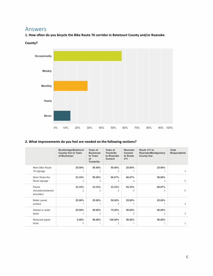
Answers 1. How often do you bicycle the Bike Route 76 corridor in Botetourt County and/or Roanoke
County?
2. What improvements do you feel are needed on the following sections?

D
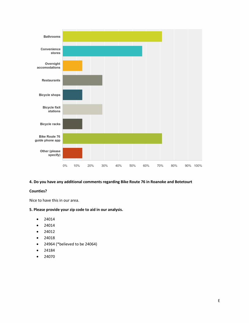
3. What amenities would cyclists be likely to use on this route?
Other: Routing kiosk to downtown Roanoke with western connections to rejoin Route 76
E
4. Do you have any additional comments regarding Bike Route 76 in Roanoke and Botetourt
Counties?
Nice to have this in our area.
5. Please provide your zip code to aid in our analysis.
• 24014
• 24014
• 24012
• 24018
• 24964 (*believed to be 24064)
• 24184
• 24070

F
Appendix B: Spurs and Alternate Routes This appendix shows several potential spur routes that could connect riders to the broader Roanoke Valley.
Catawba Valley Road (311) (west to east) – Roanoke County, Salem, City of Roanoke
• From Blacksburg Road (785) turn left on Catawba Valley Road (311). Continue south climbing
over Catawba Mountain for x miles
• Turn right on Old Catawba Road
• Continue on Old Catawba Road, descending Catawba Mountain, to Bradshaw (624)
• Turn left onto Bradshaw Road
• Continue to Catawba Valley Road (311)
• Turn right onto Catawba Valley Road
• Continue to intersection of North Electric Road (419)
• Turn right on Thompson Memorial (311), then immediate left onto Kessler Mill Road
• Continue on Kessler Mill Road (or Hanging Rock Battlefield Trail Greenway) to Main St.
approximately one 0.75 miles east of downtown City of Salem
• Turn Right onto Main Street to continue to downtown Salem, turn left onto Main Street to
continue to the City of Roanoke
• Continue on Main Street (460, 11) for x miles to Melrose Avenue
• Continue straight on Melrose to Madison Avenue
• Continue on Madison Avenue to 8th Street NW
• Turn right onto 8th Street and continue for x miles to Harrison Avenue
• Turn left onto Harrison Avenue and continue for x mile to Gainsboro Road and downtown City of
Roanoke
• Turn right onto Gainsboro Road and continue to downtown
Blue Ridge Parkway from Downtown Roanoke to Town of Buchanan (west to east)
• From downtown Roanoke City access the Blue Ridge Parkway (Route 24, Mill Mountain)
• Travel North to mile marker
• Parkway Drive (Route 43) to USBR 76 (Main Street / US 11) in the Town of Buchanan
• Continue east on USBR 76
US 11/460 (west to east) – Christiansburg to Roanoke Valley • From Depot St. turn right onto Pepper St.
• Continue on Pepper St. to Main St.
• Turn right on Main St., then immediate right onto Roanoke St (US 11)
• Continue on Roanoke St (US 11) into Roanoke Valley

G
Appendix C: VDOT Roadway Functional Classification System
Rural Functional Classification System
Rural principal arterial • Serves corridor movements of substantial statewide or interstate travel
• Serves all urban areas of 50,000 and over population and a majority of those over 25,000
• Provide an integrated network without stub connections
• Rural minor arterial
• Link cities and large towns (and other generators, such as major resorts)
• Spaced at such intervals so that all developed areas of the state are within a reasonable distance
of an arterial highway
• Provide service to corridors with trip lengths and travel density greater than those served by
rural collectors or local systems
• Design should be expected to provide for relatively high overall speeds, with minimum
interference to through movement
Rural major collector • Provide service to any county seat not on an arterial system, to larger towns not directly served
by higher systems
• Link the above to nearby larger towns or routes of higher classification
• Serve the more important intra-county travel corridors
• Rural minor collector
• Spaced at intervals, consistent with population density
• Collect traffic from local roads and bring all developed areas within a reasonable distance of a
collector road
• Provide service to the remaining smaller communities
• Link local traffic generators with their rural hinterland
Rural local • Serves primarily to provide direct access to adjacent land
• Provide service to travel over relatively short distances as compared to collectors or other higher
systems
• All facilities not on one of the higher systems
Urban Functional Classification System
Urban principal arterial • Serves the major centers of activity of a metropolitan area
• Highest traffic volume corridors
• Roads serving the longest trip desires

H
• Carry a high proportion of the total urban area travel on a minimum of mileage
• Carry significant amounts of intra-area travel
Urban minor arterial • Interconnect with and augment the urban principal arterial system and provide service to trips
of moderate length at a lower level of travel mobility than principal arterials
• Include all arterials not classified as a principal and contains facilities that place more emphasis
on land access, and offer a lower level of traffic mobility
• Urban collector
• Provides land access and traffic circulation within residential neighborhoods, commercial, and
industrial areas
• Distributes trips from the arterials through these areas to their ultimate destination
• Collects traffic from local streets and channels it to the arterial system
Urban local • All facilities not on one of the higher systems
• Serves primarily as direct access to abutting land
• Serves as access to the higher order systems
• Through traffic movement is deliberately discouraged
Source: http://www.virginiadot.org/projects/fxn_class/definitions.asp

I