A New Electoral Map for New Brunswickleg-horizon.gnb.ca/e-repository/monographs/...A New Electoral...
99
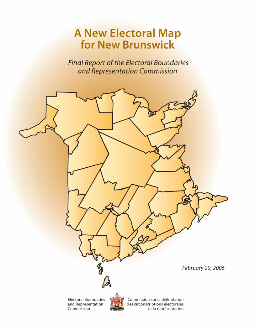
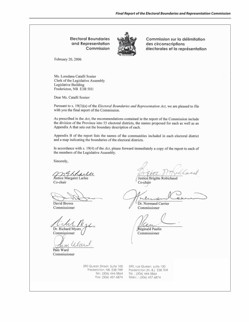
A New Electoral Map for New Brunswick Electoral Boundaries and Representation Commission Commission sur la délimitation des circonscriptions électorales et la représentation Final Report of the Electoral Boundaries and Representation Commission February 20, 2006
Transcript of A New Electoral Map for New Brunswickleg-horizon.gnb.ca/e-repository/monographs/...A New Electoral...
A New Electoral Map
for New Brunswick
Electoral Boundaries and Representation Commission
Commission sur la délimitation des circonscriptions électorales
et la représentation
Final Report of the Electoral Boundaries and Representation Commission
February 20, 2006
A New Electoral Map
for New Brunswick
Electoral Boundaries and Representation Commission
Commission sur la délimitation des circonscriptions électorales
et la représentation
Final Report of the Electoral Boundaries and Representation Commission
February 20, 2006

Final Report of the Electoral Boundaries and Representation Commission
2
February 20, 2006
3
Final Report of the Electoral Boundaries and Representation Commission

Final Report of the Electoral Boundaries and Representation Commission
4
5
Final Report of the Electoral Boundaries and Representation Commission
Table of Contents
Introduction……………………………………………………….……………………………………… .... 1
The Electoral Boundaries and Representation Act………………………………………………….………........ 1
Differences between the 1991-1993 Commission and the Current Commission………………...………….... 3
Analysis of the 2001 Census………………………………………………………………………… .............. 4
Preliminary Report…………………………………………………………………………….……………. . 4
Methodology…………………………………………………………………...……………………………. 6
Central New Brunswick……………………………………………………………………………………… 8 Southeast New Brunswick………………………………………………………………………………….. .. 16
Southwest New Brunswick………………………………………………………………………………… ... 28
Northwest New Brunswick…………………………………………………………………………………. .. 36
Northeast New Brunswick…………………………………………………………………………................ 44
General Comments and Acknowledgements……………………………………………………………..…... 55
Table: Changes from the Preliminary Report to the Final Report……………………….………………........ 56
Table: Changes to be made to the Existing Electoral Districts as a Result of the Recommendations of the Commission……………………………………………….. 58
Appendix A – Legal Descriptions of Electoral Boundaries………………..………………………………...... 68

Final Report of the Electoral Boundaries and Representation Commission
6
1
Final Report of the Electoral Boundaries and Representation Commission
Introduction
Background
On June 30, 2005, the Legislative Assembly of New Brunswick unanimously adopted the Electoral Boundaries and Representation Act. For the first time in the history of the Province, electoral redistribution will take place based on legislation.
The Lieutenant-Governor-in-Council appointed the first Commission in accordance with the Act on July 28th, 2005. The appointments took effect on August 22, 2005. These appointments were the result of the unanimous recommendation of the Legislative Administrative Committee of the Legislative Assembly. The Legislative Administrative Committee was composed of representatives from all three political parties represented in the legislature.
The composition of the Commission is as follows:
Madam Justice Margaret Larlee of Fredericton, Co-chair Madam Justice Brigitte Robichaud of Moncton, Co-chair Mr. David Brown of Saint John, Commissioner Dr. Normand Carrier of Edmundston, Commissioner Dr. Richard Myers of Fredericton, Commissioner Mr. Réginald Paulin of Lamèque, Commissioner Ms. Pam Ward of the Metepenagiag First Nation, Commissioner
The Commission held a series of public hearings throughout the Province in October 2005 and filed its preliminary report on November 21, 2005. A second round of public hearings was held in January 2006 in order to hear representations on the recommendations contained in the preliminary report of the Commission.
The Electoral Boundaries and Representation Act
The powers and duties of the Electoral Boundaries and Representation Commission are set out in the Electoral Boundaries and Representation Act that was adopted in June 2005. Here are the major characteristics of the Act:
Electoral quotient
The Act requires the Commission to calculate an electoral quotient. This is accomplished by taking the total population of New Brunswick at its last decennial census and dividing it by the total number of electoral districts. The Act stipulates that the number of electoral districts shall remain unchanged at 55. For the purpose of the current redistribution exercise, the applicable census is the 2001 Census. Therefore, the electoral quotient is calculated by dividing 729,498, being the total population of the Province at the 2001 Census by 55, the number of electoral districts. This generates an electoral quotient of 13,263. In accordance with the Act, the Commission is required to create 55 electoral districts that have a population as close as possible to this electoral quotient.
Guiding principles
The Act does permit the Commission to deviate from the electoral quotient by up to a ±10% margin based on the considerations enumerated in s. 12 of the Act that reads as follows:
12(1) Subject to subsections (2), (3) and (4), when dividing the Province into electoral districts, a Commission shall ensure that the population of each electoral district is as close as reasonably possible to the electoral quotient.
Final Report of the Electoral Boundaries and Representation Commission
2
12(2) A Commission may depart from the principle of voter parity as set out in subsection (1) in order to achieve effective representation of the electorate as guaranteed by section 3 of the Canadian Charter of Rights and Freedoms and based upon the following considerations:
(a) communities of interest; (b) effective representation of the English and French linguistic communities; (c) municipal and other administrative boundaries; (d) the rate of population growth in a region; (e) effective representation of rural areas; (f ) geographical features, including the following: (i) the accessibility of a region; (ii) the size of a region; and (iii) the shape of a region; and (g) any other considerations that the Commission considers appropriate.
12(3) If a Commission is of the opinion that it is desirable to depart from the principle of voter parity under subsection (2) when establishing an electoral district, the population of the electoral district shall deviate by no greater than 10% from the electoral quotient.
12(4) Notwithstanding subsection (3), if a Commission is of the opinion that it is desirable to depart from the principle of voter parity under subsection (2) when establishing an electoral district, in extraordinary circumstances the population of the electoral district may be more than 10% less than the electoral quotient.
While taking these considerations into account, the population of each electoral district cannot exceed a population of 14,589. According to the Act, electoral districts may have a population of less than 11,937 only if the Commission is of the opinion that “extraordinary circumstances” exist.
Hearings
The Act requires the Commission to hold two sets of public hearings: one prior to the release of its preliminary report and a second one following its release in order to provide an opportunity for the general public to make representations on the recommendations contained in the preliminary report of the Commission.
Reports
As required by the Act, the preliminary report was filed within 90 days of the establishment of the Commission and the final report within 90 days after the filing of the preliminary report. The names of the electoral districts are based on geographic considerations. As prescribed in the Act, the recommendations of both the preliminary and the final reports included the division of the Province into 55 electoral districts, the boundary description of each as well as the name proposed for each electoral district.
Objections to the final report
Section 20 of the Act allows the Commission to receive written objections to the recommendations contained in its final report as long as these objections are signed by at least two members of the Legislative Assembly. Section 20 of the Act provides the necessary guidance on the filing of written objections:
20(1) Within 14 days after the final report of a Commission is filed with the Clerk of the Legislative Assembly under paragraph 19(3)(a), a written objection to the report may be submitted to the Commission stating the following:
(a) the recommendation in the final report that is being objected to; (b) the reason for the objection; and (c) the manner in which it is proposed that the recommendation be amended.
3
Final Report of the Electoral Boundaries and Representation Commission
In such a case, the Commission is required to consider those objections within the next 30 days and finalize its report with or without amendments.
Adoption of the Final Report
Once the final report is filed, the Lieutenant-Governor-in-Council shall make a regulation prescribing the boundary description and name for each electoral district in accordance with the recommendations contained in the final report of the Commission.
According to s. 21(5) of the Act, the only amendments that may be made by the Lieutenant-Governor-in-Council to the regulation are the following:
(a) on the recommendation of the Legislative Administration Committee of the Legislative Assembly, an amendment with respect to the name of an electoral district; and
(b) an amendment to correct an error in the legal description of the boundary of an electoral district.
The Right to Vote
The Commission is mindful that the right to vote is enshrined in s.3 of the Canadian Charter of Rights and Freedoms. The scope of that right is defined by the Supreme Court of Canada in Reference Re Provincial Electoral Boundaries (Sask.), [1991] 2 S.C.R. 158; it is not voting power per se, but the right to “effective representation”. This principle was followed by the Prince Edward Island Supreme Court in MacKinnon v. Prince Edward Island (1993) 104 Nfld. & P.E.I.R. 232. The relevant factors to be taken into account in ensuring effective representation have also recently been considered in Raîche v. Canada (Attorney General) (F.C.), [2005] 1 F.C.R. 93.
Differences between the 1991-1993 Commission and the Current Commission While this is the first time that a Commission has been appointed under the current Act, it is not the first time that New Brunswick has had a redrawing of its electoral boundaries. In fact, the last one was done prior to the 1995 provincial election. The Representation and Electoral Boundaries Commission of 1991-1993 was appointed under an order-in-council under the Inquiries Act.
There are three major differences between the 1991-1993 Commission and the current Commission:
• Electors vs. population
The 1991-1993 Commission was required to refer to the number of electors in determining an electoral quotient. In accordance with the 2005 Act, the present Commission is required to utilize the total population of the Province in order to determine the electoral quotient.
• Deviation
The 1991-1993 Commission was allowed a maximum deviation of ±25% (Fundy Isles was an exception). The Act requires the present Commission to operate within a deviation of ±10%, unless there are “extraordinary circumstances” that can warrant a number lower than minus 10%.
• Role of the Legislative Assembly
The 1991-1993 Commission reported to a committee of the Legislative Assembly. The latter had the authority to make changes to the boundaries proposed by the Commission. The present Commission established under the Electoral Boundaries and Representation Act, has the final authority over its recommendations.
Final Report of the Electoral Boundaries and Representation Commission
4
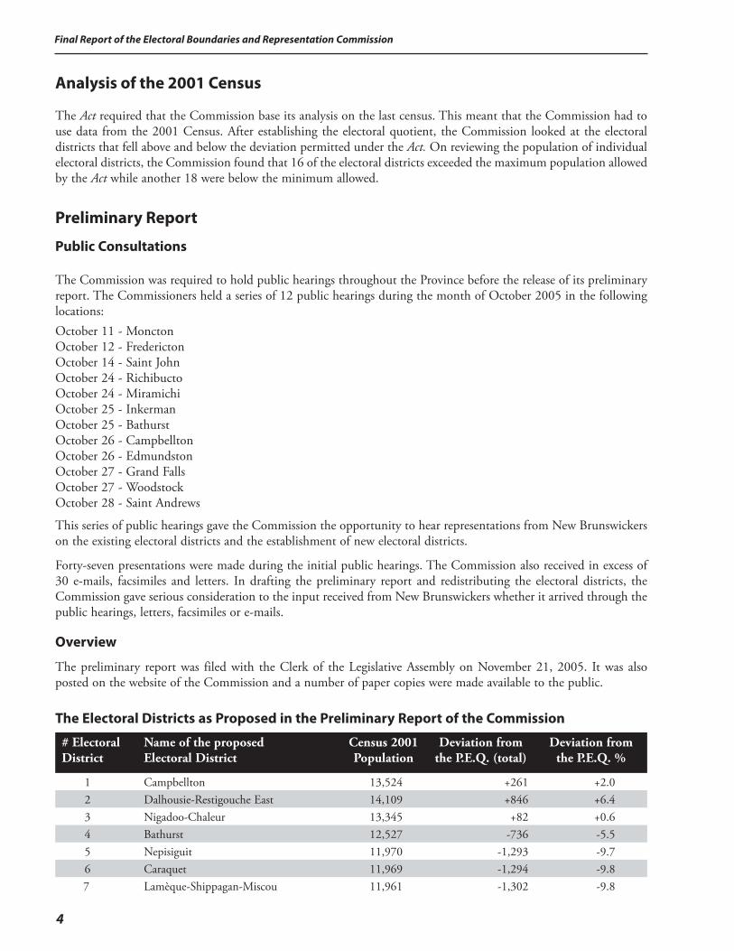
Analysis of the 2001 Census The Act required that the Commission base its analysis on the last census. This meant that the Commission had to use data from the 2001 Census. After establishing the electoral quotient, the Commission looked at the electoral districts that fell above and below the deviation permitted under the Act. On reviewing the population of individual electoral districts, the Commission found that 16 of the electoral districts exceeded the maximum population allowed by the Act while another 18 were below the minimum allowed.
Preliminary Report
Public Consultations
The Commission was required to hold public hearings throughout the Province before the release of its preliminary report. The Commissioners held a series of 12 public hearings during the month of October 2005 in the following locations:October 11 - Moncton October 12 - Fredericton October 14 - Saint John October 24 - Richibucto October 24 - Miramichi October 25 - Inkerman October 25 - Bathurst October 26 - Campbellton October 26 - Edmundston October 27 - Grand Falls October 27 - Woodstock October 28 - Saint Andrews
This series of public hearings gave the Commission the opportunity to hear representations from New Brunswickers on the existing electoral districts and the establishment of new electoral districts.
Forty-seven presentations were made during the initial public hearings. The Commission also received in excess of 30 e-mails, facsimiles and letters. In drafting the preliminary report and redistributing the electoral districts, the Commission gave serious consideration to the input received from New Brunswickers whether it arrived through the public hearings, letters, facsimiles or e-mails.
Overview
The preliminary report was filed with the Clerk of the Legislative Assembly on November 21, 2005. It was also posted on the website of the Commission and a number of paper copies were made available to the public.
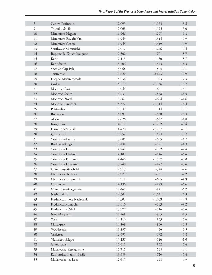
The Electoral Districts as Proposed in the Preliminary Report of the Commission
# Electoral District
Name of the proposed Electoral District
Census 2001Population
Deviation from the P.E.Q. (total)
Deviation from the P.E.Q. %
1 Campbellton 13,524 +261 +2.02 Dalhousie-Restigouche East 14,109 +846 +6.43 Nigadoo-Chaleur 13,345 +82 +0.64 Bathurst 12,527 -736 -5.55 Nepisiguit 11,970 -1,293 -9.76 Caraquet 11,969 -1,294 -9.87 Lamèque-Shippagan-Miscou 11,961 -1,302 -9.8
5
Final Report of the Electoral Boundaries and Representation Commission
8 Centre-Péninsule 12,099 -1,164 -8.89 Tracadie-Sheila 12,068 -1,195 -9.010 Miramichi-Neguac 11,966 -1,297 -9.811 Miramichi-Bay du Vin 11,949 -1,314 -9.912 Miramichi Centre 11,944 -1,319 -9.913 Southwest Miramichi 12,017 -1,246 -9.414 Rogersville-Kouchibouguac 12,502 -761 -5.715 Kent 12,113 -1,150 -8.716 Kent South 13,706 +443 +3.317 Shediac-Cap-Pelé 14,068 +805 +6.118 Tantramar 10,620 -2.643 -19.919 Dieppe-Memramcook 14,236 +973 +7.320 Codiac 14,419 +1,156 +8.721 Moncton East 13,944 +681 +5.122 Moncton South 13,731 +468 +3.523 Moncton North 13,867 +604 +4.624 Moncton-Crescent 14,377 +1,114 +8.425 Petitcodiac 13,249 -14 -0.126 Riverview 14,093 +830 +6.327 Albert 12,626 -637 -4.828 Kings East 14,515 +1,252 +9.429 Hampton-Belleisle 14,470 +1,207 +9.130 Quispamsis 13,757 +494 +3.731 Saint John-Fundy 13,888 +625 +4.732 Rothesay-Kings 13,434 +171 +1.333 Saint John East 14,245 +982 +7.434 Saint John Harbour 14,107 +844 +6.435 Saint John Portland 14,460 +1,197 +9.036 Saint John Lancaster 13,740 +477 +3.637 Grand Bay-Westfield 12,919 -344 -2.638 Charlotte-The Isles 12,972 -291 -2.239 Charlotte-Campobello 13,918 +655 +4.940 Oromocto 14,136 +873 +6.641 Grand Lake-Gagetown 12,442 -821 -6.242 Nashwaaksis 14,304 +1,041 +7.843 Fredericton-Fort Nashwaak 14,302 +1,039 +7.844 Fredericton-Lincoln 13,816 +553 +4.245 Fredericton-Odell 13,977 +714 +5.446 New Maryland 12,268 -995 -7.547 York 14,116 +853 +6.448 Mactaquac 14,169 +906 +6.849 Woodstock 13,197 -66 -0.550 Carleton 12,491 -772 -5.851 Victoria-Tobique 13,137 -126 -1.052 Grand Falls 12,411 -852 -6.453 Madawaska-Restigouche 12,715 -548 -4.154 Edmundston-Saint-Basile 13,983 +720 +5.455 Madawaska-les-Lacs 12,615 -648 -4.9
Final Report of the Electoral Boundaries and Representation Commission
6
Public Consultations on the Preliminary Report
When it released its preliminary report, the Commission invited public input and also announced a second series of public hearings to be held in January 2006. Interested individuals were invited to forward comments or suggestions directly to the Commission by e-mail at [email protected], by mail at 590 Queen Street, Suite 100, Fredericton, N.B. E3B 7H9 or by fax at 506 457-6874. Public hearings were announced for the following locations and dates:
January 11 - Grand Falls January 12 - Fredericton January 16 - Bathurst January 17 - Miramichi January 18 - Moncton January 20 - Saint John
The Commission subsequently scheduled an additional public hearing for Campbellton on Monday, January 16, 2006.
This second series of public hearings gave the Commission the opportunity to hear representations from New Brunswickers on the electoral districts proposed by the Commission in its preliminary report.
Forty-nine presentations were made during the second series of public hearings. The Commission also received in excess of 50 e-mails, facsimiles and letters and two petitions. In drafting the final report and redistributing the electoral districts, the Commission gave serious consideration to the input received from New Brunswickers whether it arrived through the public hearings, letters, facsimiles or e-mails.
Methodology
On reviewing the population of individual electoral districts, the Commission found that 16 exceeded the maximum population allowed by the Act while another 18 were below the minimum allowed. Because so many electoral districts had to undergo changes in their boundaries, the Commission undertook the review region-by-region rather than electoral district by elctoral district. The following table provides an overview of the exixting situation when the electoral districts are regrouped by economic regions.
Region
2001 Census Population
Electoral Districts
Average Population per Electoral District
Central 122,530 8 15,316Southeast 186,965 13 14,382Southwest 166,755 13 12,827Northwest 85,365 7 12,195Northeast 167,890 14 11,992
Since an electoral district cannot have a population in excess of 14,589, the approach of the Commission was to try to identify, on a priority basis, the areas where the Commission would have to add electoral districts. As an example, the Central region has a total population of 122,530 and eight electoral districts. The average population is 15,316, a number that exceeds the maximum population allowed. In such circumstances, it is clear that an electoral district needed to be added since it is impossible to keep the same number of electoral districts and meet the requirements of the Act simply by redrawing the boundaries of the existing electoral districts.
The Commission reviewed the regions in the order of the average population per electoral district starting with the region with the highest average population. The analysis and the proposals of the Commission are presented in the
7
Final Report of the Electoral Boundaries and Representation Commission
same order in this report. The reader should be able to find all the information required on his or her electoral district and the region without reference to other sections of the report.
The Act required the Commission to hold public hearings after the release of its preliminary report. The purpose was to hear representations on the recommendations contained in the report. Since the representations were in reality a reaction to the proposals of the Commission, the analysis and proposals of the preliminary report for each of the regions are being repeated in the final report. The reader should then be in a better position to understand the concerns as stated in the public input. The Commission considered each of the representations received and the final report provides an explanation as to how the Commission decided to deal with each issue.
The use of the word “existing” in describing an electoral district is a reference to the electoral districts established in 1993. The use of the expression “proposed electoral district” refers to the electoral districts as proposed in the preliminary report of the Commission.
For the purposes of the final report, the Commission makes recommendations that, as explained previously, are binding subject to the following two exceptions:
• the name of an electoral district; • the correction of an error in a legal description of the boundaries of an electoral district.
This final report contains three sections for each region:
A. Analysis and Proposals Included in the Preliminary Report of the Commission B. Public Input after the Release of the Preliminary Report C. Response and Recommendations of the Commission
Final Report of the Electoral Boundaries and Representation Commission
8
Central New Brunswick
A. Analysis and Proposals Included in the Preliminary Report of the Commission
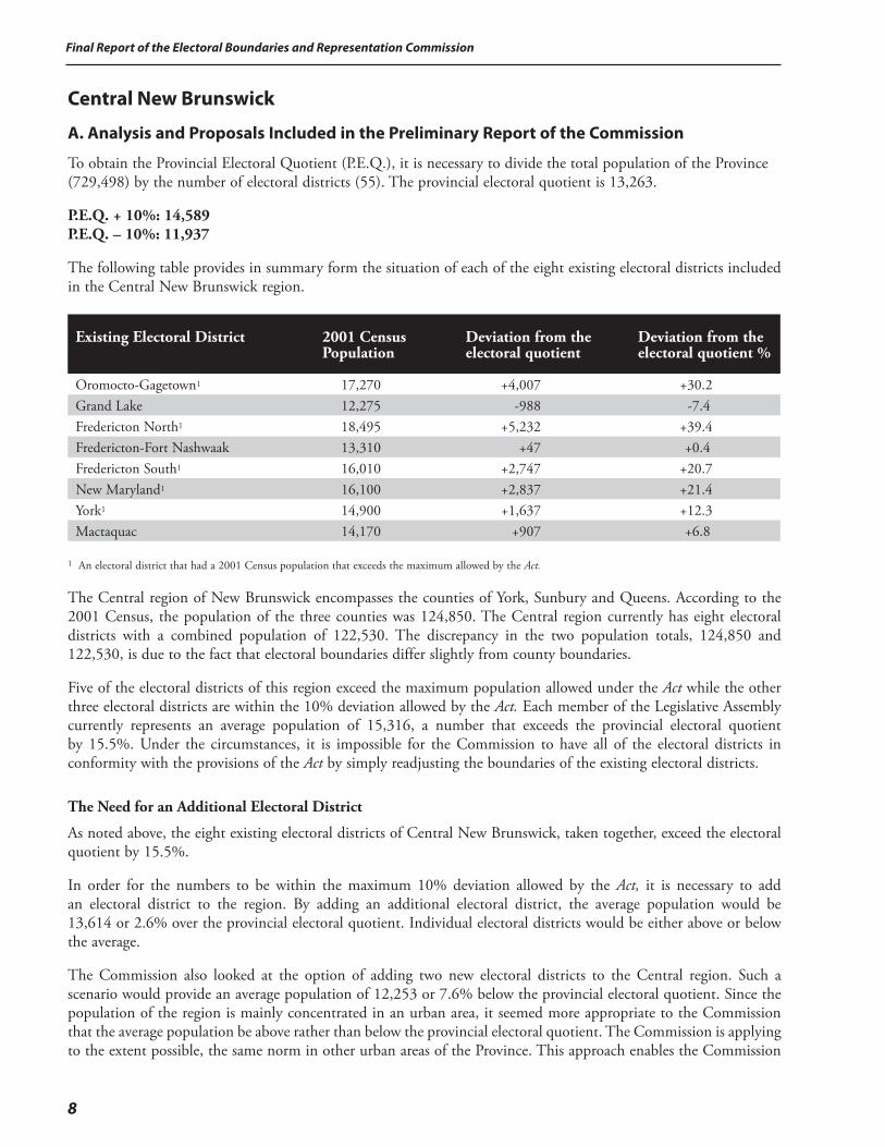
To obtain the Provincial Electoral Quotient (P.E.Q.), it is necessary to divide the total population of the Province (729,498) by the number of electoral districts (55). The provincial electoral quotient is 13,263.
P.E.Q. + 10%: 14,589 P.E.Q. – 10%: 11,937
The following table provides in summary form the situation of each of the eight existing electoral districts included in the Central New Brunswick region.
Existing Electoral District
2001 Census Population
Deviation from the electoral quotient
Deviation from the electoral quotient %
Oromocto-Gagetown1 17,270 +4,007 +30.2Grand Lake 12,275 -988 -7.4Fredericton North1 18,495 +5,232 +39.4Fredericton-Fort Nashwaak 13,310 +47 +0.4Fredericton South1 16,010 +2,747 +20.7New Maryland1 16,100 +2,837 +21.4York1 14,900 +1,637 +12.3Mactaquac 14,170 +907 +6.8
1 An electoral district that had a 2001 Census population that exceeds the maximum allowed by the Act.
The Central region of New Brunswick encompasses the counties of York, Sunbury and Queens. According to the 2001 Census, the population of the three counties was 124,850. The Central region currently has eight electoral districts with a combined population of 122,530. The discrepancy in the two population totals, 124,850 and 122,530, is due to the fact that electoral boundaries differ slightly from county boundaries.
Five of the electoral districts of this region exceed the maximum population allowed under the Act while the other three electoral districts are within the 10% deviation allowed by the Act. Each member of the Legislative Assembly currently represents an average population of 15,316, a number that exceeds the provincial electoral quotient by 15.5%. Under the circumstances, it is impossible for the Commission to have all of the electoral districts in conformity with the provisions of the Act by simply readjusting the boundaries of the existing electoral districts.
The Need for an Additional Electoral District
As noted above, the eight existing electoral districts of Central New Brunswick, taken together, exceed the electoral quotient by 15.5%.
In order for the numbers to be within the maximum 10% deviation allowed by the Act, it is necessary to add an electoral district to the region. By adding an additional electoral district, the average population would be 13,614 or 2.6% over the provincial electoral quotient. Individual electoral districts would be either above or below the average.
The Commission also looked at the option of adding two new electoral districts to the Central region. Such a scenario would provide an average population of 12,253 or 7.6% below the provincial electoral quotient. Since the population of the region is mainly concentrated in an urban area, it seemed more appropriate to the Commission that the average population be above rather than below the provincial electoral quotient. The Commission is applying to the extent possible, the same norm in other urban areas of the Province. This approach enables the Commission
9
Final Report of the Electoral Boundaries and Representation Commission
to have, to the extent possible within the confines of the legislation, rural electoral districts with a population lower than the provincial electoral quotient. The Commission recognizes that citizens living in rural areas have access to fewer elected officials than their counterparts living in incorporated areas. Consequently, the constituency workload of members of the Legislative Assembly representing rural areas is often more onerous than the workload of their colleagues who represent more urban districts.
Based on the foregoing considerations, the Commission has determined that one electoral district should be added to the Central New Brunswick region. The course of action will obviously necessitate the redrawing of most, if not all, of the boundaries of the existing eight electoral districts.
General Approach
The Commission used the following guidelines in proposing the new boundaries for the Central New Brunswick region:
• The Commission proposes to add the new electoral district to the more densely populated region of the Greater Fredericton area. In order to achieve this new scenario, some of the suburban areas around Fredericton would have to become part of the Fredericton electoral districts. This approach means that other outlying more rural districts will have to undergo boundary changes as well in order to accommodate the addition of an electoral district to the overall region.
• To the extent possible, rural districts will have a lower population than more urban districts in recognition of the fact that citizens living in non-incorporated areas of the Province do not have access to municipally-elected officials. In addition, rural members of the Legislative Assembly have to travel greater distances to serve their constituents and the communities of interest are often more diverse.
• The Commission proposes to follow, to the extent possible, the natural boundaries, especially the Saint John River, in developing the boundaries of the proposed electoral districts. At the present time, three electoral districts (York, Fredericton-Fort Nashwaak and Oromocto-Gagetown) straddle the river. Canadian Forces Base Gagetown also constitutes a natural boundary since there is a very large geographic area without resident population.
Before attempting to draw the new boundaries, the Commission reviewed the status of neighbouring electoral districts located just outside the Central region. Immediately to the west, the electoral district of Woodstock is currently just above the maximum population allowed by the Act. To the north, the population of the southwest Miramichi electoral district is currently below the number allowed by the Act. Canadian Forces Base Gagetown is located in the southern part of the region and establishes a natural divide with the electoral district of Grand Bay-Westfield, making it extremely difficult to transfer population from one area to the other for the purposes of electoral redistribution.
Proposed Electoral Districts
The Commission proposes to establish four electoral districts in the Fredericton area. The total population of the three existing electoral districts of Fredericton-Fort Nashwaak, Fredericton North and Fredericton South is 47,815 for an average of 15,938 or 20.2% above the electoral quotient. The average population, if spread over four electoral districts would be 11,953, almost 10% below the provincial electoral quotient. The Commission considers that urban areas should have a higher population base than rural areas. For this reason, the Commission proposes to include parts of neighbouring electoral districts, generally suburban areas, to the Fredericton area electoral districts in order to increase the population base of the proposed electoral districts. The Commission also proposes to use the Saint John River as a natural divide in the creation of the new electoral districts, with two electoral districts being located on each side of the river.
The four proposed electoral districts would be constituted as follows:
Final Report of the Electoral Boundaries and Representation Commission
10
Electoral District #42 –Nashwaaksis The Commission proposes that the electoral district of Nashwaaksis include: • the western portion of the existing Fredericton North electoral district (the Ring Road would serve as a major
divider between Nashwaaksis and Fredericton-Fort Nashwaak);
• the Douglas and McLeod Hill areas would be transferred from the existing electoral district of Mactaquac to the electoral district of Nashwaaksis.
The proposed electoral district would have a population of 14,304 or 7.8% above the provincial electoral quotient. The Commission also proposes Nashwaaksis as the name of the proposed electoral district.
Electoral District #43 - Fredericton-Fort Nashwaak The Commission proposes that the electoral district of Fredericton-Fort Nashwaak include: • the eastern portion of the existing Fredericton North electoral district (the Ring Road would serve as a major
divider between Nashwaaksis and Fredericton-Fort Nashwaak); • the portion of the existing Fredericton-Fort Nashwaak electoral district located north of the Saint John River; • the Pepper Creek area from the Grand Lake electoral district; • Maugerville Parish from the Grand Lake electoral district.The proposed electoral district would have a population of 14,302 or 7.8% above the provincial electoral quotient. The Commission also proposes Fredericton-Fort Nashwaak as the name of the proposed electoral district.
Electoral District #44 - Fredericton-Lincoln The Commission proposes that the electoral district of Fredericton-Lincoln include: • the portion of the Fredericton-Fort Nashwaak electoral district located south of the Saint John River;
• the eastern portion of the existing Fredericton South electoral district (the middle of Regent Street is the dividing line);
• the area from the limits of the City of Fredericton to the limits of the town of Oromocto (Lincoln area).
The population of the proposed electoral district would be 13,816 or 4.2% above the provincial electoral quotient. The Commission also proposes Fredericton-Lincoln as the name of the proposed electoral district.
Electoral District #45 – Fredericton-Odell The Commission proposes that the electoral district of Fredericton-Odell include: • the western portion of the existing electoral district of Fredericton South (the middle of Regent Street is the
dividing line);
• Bishop Drive area from the New Maryland electoral district.
The population of the proposed electoral district would be 13,977 or 5.4% above the provincial electoral quotient. The Commission also proposes Fredericton-Odell as the name of the proposed electoral district.
Electoral District #48 - MactaquacThe existing electoral district of Mactaquac has a population of 14,170, 6.8% above the provincial electoral quotient. While this number is acceptable under the terms of the Act, changes are required because of the addition of one new electoral district in the Fredericton area. As already mentioned, the Commission is proposing the following transfer: • the Douglas and McLeod Hill areas to the proposed electoral district of Nashwaaksis.
In order to accommodate the numerical situation in the neighbouring electoral district of Southwest Miramichi, the Commission is proposing the following transfer: • the McGivney area to the proposed Southwest Miramichi electoral district.
11
Final Report of the Electoral Boundaries and Representation Commission
To reflect a natural community of interest, the following areas would be transferred from the existing York electoral district to the Mactaquac electoral district: • the town of Nackawic; • the village of Millville; • the parish of Southampton.
The cumulative effect of the transfers described above is to leave the population of the proposed electoral district of Mactaquac relatively unchanged (from 14,170 to 14,169) or 6.8% above the provincial electoral quotient.
Electoral District #47 - YorkThe existing electoral district of York has a population of 14,900, 12.3% above the provincial electoral quotient. The Commission proposes to transfer that portion of the existing York electoral district located north of the Saint John River to the proposed Mactaquac electoral district. The following areas would be transferred: • the town of Nackawic; • the village of Millville; • the parish of Southampton.
In order to solve a problem of excess population in the Woodstock electoral district, the Commission proposes to transfer into the York electoral district, that portion of York County that is in the existing Woodstock electoral district. This transfer includes: • the village of Canterbury and the village of Meductic; • the parishes of Canterbury and North Lake.
The cumulative effect of the transfers described above is to decrease the population of the proposed electoral district of York from 14,900 to 14,116 or 6.4% above the provincial electoral quotient.
Electoral District #46 - New MarylandThe existing electoral district of New Maryland has a population of 16,100, 21.4% above the provincial electoral quotient. The population of the electoral district has to be reduced substantially in order to meet the requirements of the Act and to assist in the creation of the proposed electoral districts in the Fredericton area. The Commission is, therefore, proposing to transfer the following: • the area from the limits of the City of Fredericton to the limits of the town of Oromocto (Lincoln area) to
the proposed electoral district of Fredericton-Lincoln;
• the Bishop Drive area to the proposed electoral district of Fredericton-Odell.
The cumulative effect of the transfers described above is to decrease the population of the proposed electoral district of New Maryland from 16,100 to 12,268 or 7.5% below the provincial electoral quotient.
Electoral District #41 – Grand Lake-GagetownThe existing electoral district of Grand Lake has a population of 12,275, 7.4% below the provincial electoral quotient. While the population is acceptable under the terms of the Act, changes are required because of the creation of the proposed electoral districts in the Fredericton area. As indicated earlier, the Commission proposes to transfer the following areas to the proposed electoral district of Fredericton-Fort Nashwaak: • the parish of Maugerville; • the Pepper Creek area.
The Commission also proposes to transfer the following area located in the existing Grand Lake electoral district to the proposed Petitcodiac electoral district due to the community of interest factor: • Brunswick Parish.
Final Report of the Electoral Boundaries and Representation Commission
12
The Commission is proposing to add the following areas from the existing electoral district of Oromocto-Gagetown to the proposed electoral district of Grand Lake-Gagetown: • the Village of Cambridge Narrows and the Village of Gagetown;
• the parishes of Cambridge Narrows, Gagetown, Hampstead, Wickham, and the remaining portion of the parish of Johnson.
The cumulative effect of the transfers described above would be to increase the population of the proposed electoral district of Grand Lake-Gagetown from 12,275 to 12,442 or 6.2% below the provincial electoral quotient. The Commission also proposes to change the name of the electoral district from Grand Lake to Grand Lake-Gagetown in order to reflect the fact that the Gagetown area would now be part of the proposed Grand Lake-Gagetown electoral district.
Electoral District #40 – OromoctoThe existing electoral district of Oromocto-Gagetown has a population of 17,270, 30.2% above the provincial electoral quotient. The population of the electoral district has to be reduced substantially in order to meet the requirements of the Act. Because Grand Lake is the only adjoining electoral district that is below the electoral quotient, the Commission is proposing to reduce the size of the Oromocto-Gagetown electoral district by transferring the following areas to the proposed Grand Lake-Gagetown electoral district: • the Village of Cambridge Narrows and the Village of Gagetown;
• the parishes of Cambridge Narrows, Gagetown, Hampstead, Wickham, and the remaining portion of the parish of Johnston.
The cumulative effect of the transfers described above would be to decrease the population of the proposed electoral district of Oromocto from 17,270 to 14,136 or 6.6% above the provincial electoral quotient. The Commission also proposes to change the name of the electoral district from Oromocto-Gagetown to Oromocto in order to reflect the fact that the Gagetown area is now part of another electoral district.
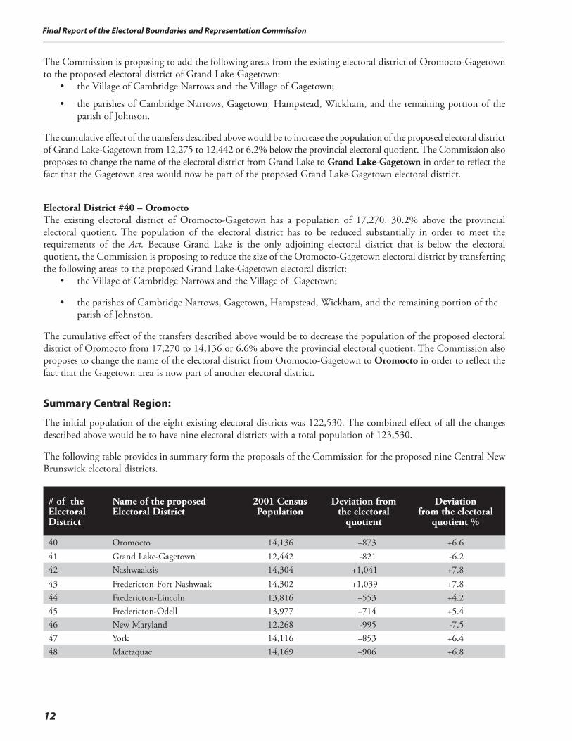
Summary Central Region:
The initial population of the eight existing electoral districts was 122,530. The combined effect of all the changes described above would be to have nine electoral districts with a total population of 123,530.
The following table provides in summary form the proposals of the Commission for the proposed nine Central New Brunswick electoral districts.
# of the Electoral District
Name of the proposed Electoral District
2001 Census Population
Deviation from
the electoral quotient
Deviation
from the electoral quotient %
40 Oromocto 14,136 +873 +6.641 Grand Lake-Gagetown 12,442 -821 -6.242 Nashwaaksis 14,304 +1,041 +7.843 Fredericton-Fort Nashwaak 14,302 +1,039 +7.844 Fredericton-Lincoln 13,816 +553 +4.245 Fredericton-Odell 13,977 +714 +5.446 New Maryland 12,268 -995 -7.547 York 14,116 +853 +6.448 Mactaquac 14,169 +906 +6.8
13
Final Report of the Electoral Boundaries and Representation Commission
The preliminary report of the Commission would have the following impact and its proposals would bring about the following changes to the electoral map of the Central New Brunswick region:
• The number of electoral districts would be increased from eight to nine. Adding one electoral district would decrease the average population of each electoral district from 15,316 (15.5% above the provincial electoral quotient) to 13,726 (3.5% above the provincial electoral quotient).
• Under the current situation, five of the eight electoral districts located in the Central New Brunswick region do not meet the requirements of the Act. Under the proposals contained in the preliminary report, all nine electoral districts would conform to the provisions of the Act.
• A new electoral district would be added in the Fredericton urban area. Suburban areas would need to be brought into the central core to provide the numbers required in order to establish the new electoral district. In addition, the boundaries of the three existing Fredericton electoral districts would need to undergo significant changes.
• The variance in the population of the existing electoral district is from plus 39.4% to minus 7.4%. Under the proposals contained in the preliminary report, the variance would range from plus 7.8% to minus 6.2%. Under the current distribution, the range is from a population of 5,232 above the provincial electoral quotient to a population of 988 under the quotient. The propositions contained in the preliminary report provide a scenario where the electoral district with the highest number has a population of 1,041 above the provincial quotient while the electoral district with the lowest number has a population of 821 below the quotient. In absolute terms, the gap between the electoral districts with the highest and the lowest populations would be narrowed from 6,220 to 1,862.
• Currently, three of the eight existing electoral districts straddle the Saint John River. Under the proposals contained in the preliminary report, only one of the nine electoral districts (Grand Lake-Gagetown) would be located on both sides of the river.
• The addition of suburban areas to the Fredericton urban area would have the effect of increasing the rural nature of the outlying electoral districts.
B. Public Input after the Release of the Preliminary Report
Further to the release of its preliminary report, the Commission received the following representations that would have an impact on the Central region:
1. The dividing line between the two proposed electoral districts located on the north side of the Saint John River, Fredericton-Fort Nashwaak and Nashwaaksis should be drawn differently. Starting at the river, the line should go along the Ring Road as far as Two Nations Crossing and then along St. Mary’s Street/Killarney Road to its intersection with Brookside Drive.
2. The Saint John River should not be used as a dividing line between electoral districts. Electoral districts should straddle the river.
3. Three of the proposed electoral districts serving Fredericton include the name of the city, therefore, the name of the proposed electoral district of Nashwaaksis should be changed to Fredericton-Nashwaaksis in order to be more consistent with the names proposed for the other electoral districts in the area.
4. The name of the proposed electoral district of Fredericton-Odell should revert to Fredericton South.
5. The portion of York County in the existing electoral district of Woodstock should remain in the proposed electoral district of Woodstock and not be transferred to the proposed electoral district of York.
6. The electoral boundaries of the existing electoral district of Mactaquac should remain the same. More specifically, the area of Estey’s Bridge, Chateau Heights and McLeod Hill should not be transferred to the proposed electoral district of Nashwaaksis.
7. The name of the proposed electoral district of Oromocto should be changed to Oromocto-Geary-Burton.
Final Report of the Electoral Boundaries and Representation Commission
14
C. Response to the Public Input and Recommendations of the Commission for the Central New Brunswick Region
In arriving at its decisions concerning the electoral districts of Central New Brunswick, the Commission reviewed carefully the representations it received at the public hearings and correspondence sent to the office of the Commission. The representations were also reviewed in the context of the preceding regional analysis of this report.
Public Input:1. The dividing line between the two proposed electoral districts located on the north side of the Saint John River, Fredericton-
Fort Nashwaak and Nashwaaksis should be drawn differently. Starting at the river, the line should go along the Ring Road as far as Two Nations Crossing and then along St. Mary’s Street/Killarney Road to its intersection with Brookside Drive.
Response of the Commission:The preliminary report of the Commission proposed two electoral districts on the north side of the Saint John River with almost equal populations based on the 2001 Census (14,304 versus 14,302). The alternative option presented at the hearing, if retained by the Commission, would mean that the proposed electoral district of Nashwaaksis would have a population in excess of the maximum allowed by the provisions of the Act. To remedy the situation would therefore necessitate the transfer of part of the proposed electoral district of Nashwaaksis to the proposed electoral district of Mactaquac. Under the circumstances, the Commission maintains its original proposal and will so recommend rather than the alternative option presented by an intervener at the public hearing.
Public Input:2. The Saint John River should not be used as a dividing line between electoral districts. Electoral districts should straddle
the river.
Response of the Commission:The Commission heard a representation at its public hearing in Fredericton prior to the preparation of its preliminary report that the river should be used as a natural boundary. The Commission agrees with the submission received during the October hearings and its position remains unchanged.
Public Input:3. Three of the proposed electoral districts serving Fredericton include the name of the City, therefore, the name of
the proposed electoral district of Nashwaaksis should be changed to Fredericton-Nashwaaksis in order to be more consistent with the names proposed for the other electoral districts in the area.
Response of the Commission:The Commission agrees and will recommend Fredericton-Nashwaaksis as the name of the electoral district.
Public Input:4. The name of the proposed electoral district of Fredericton-Odell should revert to Fredericton South.
Response of the Commission:A substantial number of the residents of the current riding of Fredericton South will now be located in the riding of Fredericton-Lincoln. In order to minimize confusion and for consistency, the Commission prefers another option mentioned during the public hearing, namely Fredericton-Silverwood.
Public Input:5. The portion of York County in the existing electoral district of Woodstock should remain in the proposed electoral district
of Woodstock and not be transferred to the proposed electoral district of York.
15
Final Report of the Electoral Boundaries and Representation Commission
Response of the Commission:In its preliminary report, the Commission proposed to transfer the portion of York County located in the existing electoral district of Woodstock to the proposed electoral district of York. The reason for the proposal was to correct the overpopulation of the electoral district of Woodstock that currently exceeds the 10% deviation allowed by the Act. Based on the representations received, the Commission has been persuaded that the community of interest factor would be best served if the portion of York County in the existing Woodstock electoral district were to continue to be part of the proposed electoral district of Woodstock. This area consists of the villages of Canterbury and Meductic and the parishes of Canterbury and North Lake.
The Commission has to take into account the impact that the transfer will have on both electoral districts of York and Woodstock. The effect on the proposed electoral district of York will be to decrease its population from 14,116 to 12,723 or 4.1% below the electoral quotient. The Commission considers this situation acceptable, given the relatively rural nature of the electoral district.
The Commission has identified an alternative solution to remedy the overpopulation of the Woodstock electoral district and will address this issue when dealing with the Northwest region of the Province.
Public Input: 6. The electoral boundaries of the existing electoral district of Mactaquac should remain the same. More specifically,
the area of Estey’s Bridge, Chateau Heights and McLeod Hill should not be transferred to the proposed electoral district of Nashwaaksis.
Response of the Commission:The Commission determined that one electoral district had to be added to the Central region due to overpopulation in the existing electoral districts. According to the 2001 Census, the population of the city of Fredericton was 47,560. If the Commission had established four electoral districts within the city boundaries, each of the electoral districts would have been close to 10% below the electoral quotient. The Commission believes that urban areas should, to the extent possible, have electoral districts with a population above the electoral quotient. Therefore, the Commission has decided to include suburban areas from outside the limits of the city of Fredericton in establishing the four Fredericton area electoral districts.
Public Input 7. The name of the proposed electoral district of Oromocto should be changed to Oromocto-Geary-Burton.
Response of the Commission:The Commission maintains its recommendation that the name of the electoral district should be Oromocto.
Note: The names of the electoral districts form part of the final report of the Commission. However, the names may be amended by the Lieutenant-
Governor-in-Council on the recommendation of the Legislative Administrative Committee.
Final Report of the Electoral Boundaries and Representation Commission
16
Southeast New Brunswick
A. Analysis and Proposals Included in the Preliminary Report of the Commission
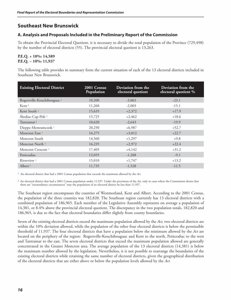
To obtain the Provincial Electoral Quotient, it is necessary to divide the total population of the Province (729,498) by the number of electoral districts (55). The provincial electoral quotient is 13,263.
P.E.Q. + 10%: 14,589 P.E.Q. – 10%: 11,937
The following table provides in summary form the current situation of each of the 13 electoral districts included in Southeast New Brunswick.
Existing Electoral District
2001 Census Population
Deviation from the electoral quotient
Deviation from the electoral quotient %
Rogersville-Kouchibouguac 2 10,200 -3,063 -23.1Kent 2 11,260 -2,003 -15.1Kent South 1 15,635 +2,372 +17.9Shediac-Cap-Pelé 1 15,725 +2,462 +18.6Tantramar 2 10,620 -2,643 -19.9Dieppe-Memramcook 1 20,250 +6,987 +52.7Moncton East 1 16,275 +3,012 +22.7Moncton South 14,560 +1,297 +9.8Moncton North 1 16,235 +2,972 +22.4Moncton Crescent 1 17,405 +4,142 +31.2Petitcodiac 12,055 -1,208 -9.1Riverview 1 15,010 +1,747 +13.2Albert 2 11,735 -1,528 -11.5
1 An electoral district that had a 2001 Census population that exceeds the maximum allowed by the Act.
2 An electoral district that had a 2001 Census population under 11,937. Under the provisions of the Act, only in cases where the Commission deems that there are “extraordinary circumstances” may the population of an electoral district be less than 11,937.
The Southeast region encompasses the counties of Westmorland, Kent and Albert. According to the 2001 Census, the population of the three counties was 182,820. The Southeast region currently has 13 electoral districts with a combined population of 186,965. Each member of the Legislative Assembly represents on average a population of 14,381, or 8.4% above the provincial electoral quotient. The discrepancy in the two population totals, 182,820 and 186,965, is due to the fact that electoral boundaries differ slightly from county boundaries.
Seven of the existing electoral districts exceed the maximum population allowed by the Act, two electoral districts are within the 10% deviation allowed, while the population of the other four electoral districts is below the permissible threshold of 11,937. The four electoral districts that have a population below the minimum allowed by the Act are located on the periphery of the region: Rogersville-Kouchibouguac and Kent to the north, Petitcodiac to the west and Tantramar to the east. The seven electoral districts that exceed the maximum population allowed are generally concentrated in the Greater Moncton area. The average population of the 13 electoral districts (14,381) is below the maximum number allowed by the legislation. Nevertheless, it is not possible to rearrange the boundaries of the existing electoral districts while retaining the same number of electoral districts, given the geographical distribution of the electoral districts that are either above or below the population levels allowed by the Act.
17
Final Report of the Electoral Boundaries and Representation Commission
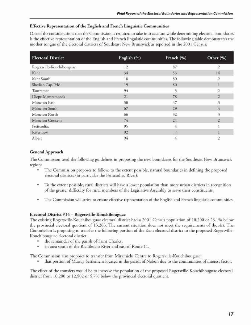
Effective Representation of the English and French Linguistic Communities
One of the considerations that the Commission is required to take into account while determining electoral boundaries is the effective representation of the English and French linguistic communities. The following table demonstrates the mother tongue of the electoral districts of Southeast New Brunswick as reported in the 2001 Census:
Electoral District
English (%)
French (%)
Other (%)
Rogersville-Kouchibouguac 12 87 2Kent 34 53 14Kent South 18 80 2Shediac-Cap-Pelé 19 80 1Tantramar 94 3 2Diepe-Memramcook 21 78 2Moncton East 50 47 3Moncton South 67 29 4Moncton North 66 32 3Moncton Crescent 74 24 2Petitcodiac 95 4 1Riverview 92 7 1Albert 94 4 2
General Approach
The Commission used the following guidelines in proposing the new boundaries for the Southeast New Brunswick region: • The Commission proposes to follow, to the extent possible, natural boundaries in defining the proposed
electoral districts (in particular the Petitcodiac River).
• To the extent possible, rural districts will have a lower population than more urban districts in recognition of the greater difficulty for rural members of the Legislative Assembly to serve their constituents.
• The Commission will strive to ensure effective representation of the English and French linguistic communities.
Electoral District #14 – Rogersville-KouchibouguacThe existing Rogersville-Kouchibouguac electoral district had a 2001 Census population of 10,200 or 23.1% below the provincial electoral quotient of 13,263. The current situation does not meet the requirements of the Act. The Commission is proposing to transfer the following portion of the Kent electoral district to the proposed Rogersville-Kouchibouguac electoral district: • the remainder of the parish of Saint Charles; • an area south of the Richibucto River and east of Route 11.
The Commission also proposes to transfer from Miramichi Centre to Rogersville-Kouchibouguac: • that portion of Murray Settlement located in the parish of Nelson due to the communities of interest factor.
The effect of the transfers would be to increase the population of the proposed Rogersville-Kouchibouguac electoral district from 10,200 to 12,502 or 5.7% below the provincial electoral quotient.
Final Report of the Electoral Boundaries and Representation Commission
18
Electoral District #15 – KentThe existing Kent electoral district had a 2001 Census population of 11,260 or 15.1% below the provincial electoral quotient of 13,263. The current situation does not meet the requirements of the Act. Furthermore, the Commission is proposing to transfer the following portion of the existing Kent electoral district to the proposed Rogersville-Kouchibouguac electoral district: • the remainder of the parish of Saint Charles; • an area south of the Richibucto River and east of Route 11.
The Commission is also proposing to transfer the following areas from Kent South into Kent: • the town of Buctouche; • the remaining part of Saint Maurice and Bouctouche Cove; • Saint Joseph de Kent; • part of McIntosh Hill; • Buctouche No. 16 reserve.
The effect of the transfers would be to increase the population of the proposed Kent electoral district from 11,260 to 12,114 or 8.7% below the provincial electoral quotient.
Electoral District #16 – Kent SouthThe existing Kent South electoral district had a 2001 Census population of 15,635, 17.9% above the provincial electoral quotient. This number is higher than allowed by the Act and consequently the population of the electoral district must be reduced. The Commission proposes to transfer the following to the proposed Kent electoral district: • the town of Bouctouche; • the remaining part of Saint Maurice and Bouctouche Cove; • Saint Joseph de Kent; • part of McIntosh Hill; • Buctouche No. 16 reserve.
The Commission proposes to transfer the following to the Petitcodiac electoral district: • Indian Mountain (Route 490); • the part of the community of Dundas located in Westmorland.
The Commission proposes to transfer the following area from the existing Shediac-Cap-Pelé electoral district to the proposed Kent South electoral district: • an area along the shore northwest of Shediac.
The Commission proposes to transfer the following areas from the Moncton Crescent electoral district to the Kent South electoral district: • the remaining part of Saint Philippe; • the remaining part of Irishtown.
The effect of the transfers would be to decrease the population of the proposed Kent South electoral district from 15,635 to 13,706 or 3.3% over the provincial electoral quotient.
Electoral District #17 – Shediac-Cap-PeléThe existing Shediac-Cap-Pelé electoral district had a 2001 Census population of 15,725, or 18.6% above the provincial electoral quotient. This number is higher than allowed by the Act and consequently the population of the electoral district must be reduced. The Commission proposes to transfer the following to the Kent South electoral district: • an area along the shore northwest of Shediac.
19
Final Report of the Electoral Boundaries and Representation Commission
The Commission also proposes to transfer the following area to the electoral district of Dieppe-Memramcook: • Scoudouc and Calhoun.
The effect of the transfers would be to decrease the population of the proposed Shediac-Cap-Pelé electoral district from 15,725 to 14,068 or 6.1% over the provincial electoral quotient.
Electoral District #18 – TantramarThe existing Tantramar electoral district had a 2001 Census population of 10,620, or 19.9% below the provincial electoral quotient of 13,263. The electoral district does not fall within the 10% deviation as provided for in the Act. The Commission initially examined three options to correct the situation: • combine the Tantramar electoral district with part of the Shediac-Cap-Pelé electoral district; • combine the Tantramar electoral district with part of the Dieppe-Memramcook electoral district; • split the Tantramar electoral district into two and combine one part with part of the Shediac-Cap-Pelé
electoral district and the other with part of the Dieppe-Memramcook electoral district.
The Commission considers that all three options initially reviewed bring to the forefront the issue of the effective representation of the English and French linguistic communities. The mother tongue of the population of the Tantramar electoral district is predominately English at 94% while the mother tongue of the neighbouring electoral districts of Shediac-Cap-Pelé and Dieppe-Memramcook is French at 80% and 78% respectively.
The Commission considered proposing that the existing Tantramar electoral district remain undivided and that part of the neighbouring electoral districts of Shediac-Cap-Pelé or Dieppe-Memramcook be added to it to bring the population of Tantramar within the 10% deviation from the provincial electoral quotient. The end result would have been that a mainly Francophone minority would become part of an essentially Anglophone electoral district. Alternatively, the Commission considered proposing that the existing Tantramar electoral district be divided into two and that one part be combined with part of the neighbouring electoral district of Shediac-Cap-Pelé and the other with the Dieppe-Memramcook electoral district. Under such a scenario, the end result would have been that the mainly Anglophone population of the current Tantramar electoral district would find itself divided into two separate mainly Francophone electoral districts.
The Commission does not believe that the three options referred to above would provide effective representation of the English and French linguistic communities. The Commission has not been able to identify an alternative viable option that would on the one hand, bring the electoral district of Tantramar within 10% of the provincial electoral quotient, and on the other hand respect the criteria set out in the Act.
The Commission deems that the situation is indeed one of “extraordinary circumstances” as contemplated by s.12(4) of the Act. The Commission, therefore, proposes to leave the boundaries of the Tantramar electoral district unchanged with a Census 2001 population of 10,620 or 19.9% below the provincial electoral quotient.
Electoral District #19 – Dieppe-MemramcookThe existing Dieppe-Memramcook electoral district had a 2001 Census population of 20,250, 52.7% above the provincial electoral quotient. This number is higher than allowed by the Act and consequently the population of the electoral district must be reduced. The Commission proposes to transfer the following from the Shediac-Cap-Pelé electoral district to the proposed Dieppe-Memramcook electoral district: • Scoudouc and Calhoun.
The Commission also proposes to transfer the following to the new electoral district of Codiac: • that part of the city of Dieppe that is located north of the Chartersville Road and Champlain Street.
The effect of the transfers would be to decrease the population of the proposed Dieppe-Memramcook electoral district from 20,250 to 14,236 or 7.3% over the provincial electoral quotient.

Final Report of the Electoral Boundaries and Representation Commission
20
Electoral District #20 – CodiacThe Commission is proposing to establish a new electoral district that would include the following: • that part of the city of Dieppe that is located north of the Chartersville Road and Champlain Street;
• that part of the current Moncton East electoral district located generally east of Mill Road and Lewisville Road but not including the portion east of Elmwood Drive;
• the Harrisville and Lakeville areas currently in Moncton Crescent.
The proposals of the Commission would create an electoral district with a population of 14,419 or 8.7% over the provincial electoral quotient. The Commission also proposes that the name of the new electoral district be Codiac.
Electoral District #21 – Moncton EastThe existing Moncton East electoral district had a 2001 Census population of 16,275, 22.7% above the provincial electoral quotient. This number is higher than allowed by the Act and consequently the population of the electoral district must be reduced. The Commission proposes to transfer the following to the new electoral district of Codiac: • that part of the existing Moncton East electoral district located generally east of Mill Road and Lewisville
Road but not including the portion east of Elmwood Drive.
The Commission is proposing to transfer the following from the Moncton North electoral district to the Moncton East electoral district: • the area east of High Street and north of Mountain Road.
The Commission is also proposing to transfer the following from the Moncton South electoral district to Moncton East electoral district: • the area east of Church Street.
The effect of the transfers would be to decrease the population of the proposed Moncton East electoral district from 16,275 to 13,944 or 5.1% over the provincial electoral quotient.
Electoral District #22 – Moncton SouthThe existing Moncton South electoral district had a 2001 Census population of 14,560 or 9.8% above the provincial electoral quotient. This number is acceptable under the terms of the Act, however, because of the adjustment required in electoral districts that surround it and the need to bring those other electoral districts within the numbers allowed by the Act, the Commission proposes to transfer the following to the Moncton East electoral district: • the area east of Church Street.
The effect of the transfer would be to decrease the population of the proposed Moncton South electoral district from 14,560 to 13,731 or 3.5% over the provincial electoral quotient.
Electoral District #23 – Moncton NorthThe existing Moncton North electoral district had a 2001 Census population of 16,235, 22.4% above the provincial electoral quotient. This number is higher than allowed by the Act and consequently the population of the electoral district must be reduced. The Commission proposes to transfer the following to the Moncton East electoral district: • the area east of High Street and north of Mountain Road.
The Commission is also proposing to transfer the following from the Moncton North electoral district to the Moncton Crescent electoral district: • Westbrook Circle.
The effect of the transfers would be to decrease the population of the proposed Moncton North electoral district from 16,235 to 13,867 or 4.6% over the provincial electoral quotient.
21
Final Report of the Electoral Boundaries and Representation Commission
Electoral District #24 – Moncton CrescentThe existing Moncton Crescent electoral district had a 2001 Census population of 17,405, 31.2% above the provincial electoral quotient. This number is higher than allowed by the Act and consequently the population of the electoral district must be reduced. The Commission is proposing to transfer the following area from the Moncton North electoral district to the proposed Moncton Crescent electoral district: • Westbrook Circle.
The Commission is proposing to transfer the following area from the Moncton Crescent electoral district to the new Codiac electoral district: • Harrisville Boulevard and Lakeville.
The Commission is proposing to transfer from the Moncton Crescent to the Petitcodiac electoral district the following: • the community of Ammon; • the remaining part of Stilesville; • the remaining part of Lutes Mountain.
The Commission proposes to transfer the following areas from the Moncton Crescent electoral district to the Kent South electoral district: • the remaining part of Saint Philippe; • the remaining part of Irishtown.
The effect of the transfers would be to decrease the population of the proposed Moncton Crescent electoral district from 17,405 to 14,377 or 8.4% over the provincial electoral quotient.
Electoral District #25 – PetitcodiacThe existing Petitcodiac electoral district had a 2001 Census population of 12,055, or 9.1% below the provincial electoral quotient of 13,263. The current population meets the requirements of the Act. However, the Commission proposes to add the following portion of the Grand Lake electoral district to the proposed Petitcodiac electoral district due to the communities of interest factor: • Brunswick Parish.
The Commission proposes to add the following communities from the Kings East electoral district: • Head of Millstream, Carsonville and Summerfield.
The Commission proposes to add the following area from the Moncton Crescent electoral district: • the community of Ammon; • the remaining part of Stilesville; • the remaining part of Lutes Mountain.
Due to the communities of interest factor, the Commission also proposes to add the following area from the Kent South and Moncton Crescent electoral districts: • Route 490.
The effect of the transfers would be to increase the population of the proposed Petitcodiac electoral district from 12,055 to 13,249 or 0.1% below the provincial electoral quotient.
Final Report of the Electoral Boundaries and Representation Commission
22
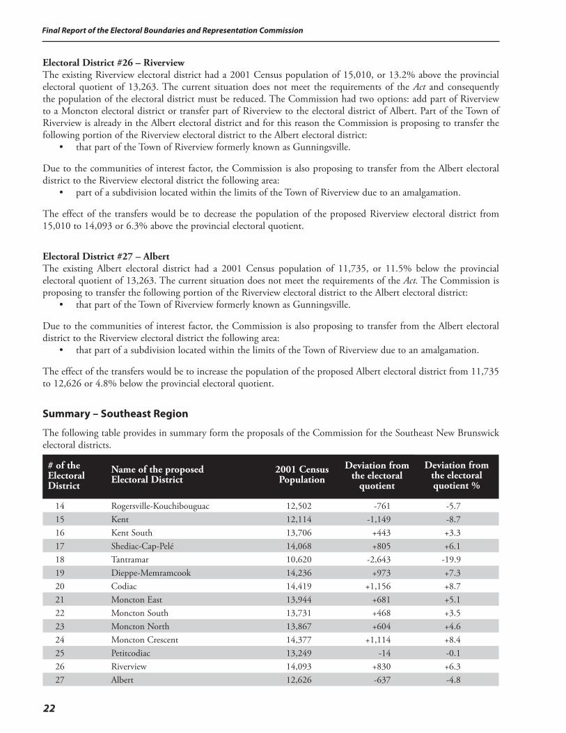
Electoral District #26 – RiverviewThe existing Riverview electoral district had a 2001 Census population of 15,010, or 13.2% above the provincial electoral quotient of 13,263. The current situation does not meet the requirements of the Act and consequently the population of the electoral district must be reduced. The Commission had two options: add part of Riverview to a Moncton electoral district or transfer part of Riverview to the electoral district of Albert. Part of the Town of Riverview is already in the Albert electoral district and for this reason the Commission is proposing to transfer the following portion of the Riverview electoral district to the Albert electoral district: • that part of the Town of Riverview formerly known as Gunningsville.
Due to the communities of interest factor, the Commission is also proposing to transfer from the Albert electoral district to the Riverview electoral district the following area: • part of a subdivision located within the limits of the Town of Riverview due to an amalgamation.
The effect of the transfers would be to decrease the population of the proposed Riverview electoral district from 15,010 to 14,093 or 6.3% above the provincial electoral quotient.
Electoral District #27 – AlbertThe existing Albert electoral district had a 2001 Census population of 11,735, or 11.5% below the provincial electoral quotient of 13,263. The current situation does not meet the requirements of the Act. The Commission is proposing to transfer the following portion of the Riverview electoral district to the Albert electoral district: • that part of the Town of Riverview formerly known as Gunningsville.
Due to the communities of interest factor, the Commission is also proposing to transfer from the Albert electoral district to the Riverview electoral district the following area: • that part of a subdivision located within the limits of the Town of Riverview due to an amalgamation.
The effect of the transfers would be to increase the population of the proposed Albert electoral district from 11,735 to 12,626 or 4.8% below the provincial electoral quotient.
Summary – Southeast Region
The following table provides in summary form the proposals of the Commission for the Southeast New Brunswick electoral districts.
# of the Electoral District
Name of the proposed Electoral District
2001 Census Population
Deviation from the electoral
quotient
Deviation from the electoral quotient %
14 Rogersville-Kouchibouguac 12,502 -761 -5.715 Kent 12,114 -1,149 -8.716 Kent South 13,706 +443 +3.317 Shediac-Cap-Pelé 14,068 +805 +6.118 Tantramar 10,620 -2,643 -19.919 Dieppe-Memramcook 14,236 +973 +7.320 Codiac 14,419 +1,156 +8.721 Moncton East 13,944 +681 +5.122 Moncton South 13,731 +468 +3.523 Moncton North 13,867 +604 +4.624 Moncton Crescent 14,377 +1,114 +8.425 Petitcodiac 13,249 -14 -0.126 Riverview 14,093 +830 +6.327 Albert 12,626 -637 -4.8
23
Final Report of the Electoral Boundaries and Representation Commission
The preliminary report of the Commission would have the following impact and its proposals would bring about the following changes to the electoral map of the Southeast New Brunswick region:
• The number of electoral districts would be increased from 13 to 14. Adding one electoral district would decrease the average population of each electoral district from 14,382 (8.4% above the provincial electoral quotient) to 13,397 (1.0% above the provincial electoral quotient).
• The new electoral district would be added in the Moncton-Dieppe urban area. The boundaries of most of the existing urban districts will need to undergo significant changes.
• Under the current situation, 11 of the 13 existing electoral districts located in the Southeast New Brunswick region do not meet the requirements of the Act. Under the proposals contained in the preliminary report of the Commission, 13 of the 14 electoral districts would come within 10% of the provincial electoral quotient and would conform to the provisions of the Act. In the case of the Tantramar electoral district, the Commission proposes to invoke the “extraordinary circumstances” provision of the Act. Therefore all 14 electoral districts conform to the provision of the Act.
• The variance in the population of the existing electoral districts is from plus 52.7% over the provincial electoral quotient to minus 23.1% under the quotient. Under the proposals contained in the preliminary report, the variance would be from plus 8.7% to minus 19.9%. Under the current distribution, the range is from a population of 6,987 above the provincial electoral quotient to a population of 3,063 under the quotient. The propositions contained in the preliminary report provide a scenario where the electoral district with the highest number has a population of 1,156 above the provincial quotient while the electoral district with the lowest number of population is 2,643 below the quotient. In absolute terms the gap between the two electoral districts with the highest and the lowest populations would be narrowed from 10,050 to 3,799.
B. Public Input after the Release of the Preliminary Report
Further to the release of its preliminary report, the Commission received the following representations that would have an impact on the Southeast Region:
1. The communities of Jardineville, Richibuctou-Village, Galloway, and Indian Island should remain in the proposed electoral district of Kent and not be transferred to the proposed electoral district of Rogersville-Kouchibouguac.
2. The town of Bouctouche should remain in the proposed electoral district of Kent South and not be transferred to the proposed electoral district of Kent.
3. The Shediac Cape Local Service District area should remain in the proposed Shediac-Cap-Pelé electoral district and not be transferred to the proposed electoral district of Kent South.
4. The Scoudouc and Scoudouc Road areas should remain in the proposed Shediac-Cap-Pelé electoral district and not be transferred to the proposed Dieppe-Memramcook electoral district.
5. The area of Humphrey-Lewisville-Sunny Brae should not be split into two separate electoral districts.
6. A number of representations, not all consistent with each other, were made in relation to the city of Dieppe and surrounding areas:
i) The city of Dieppe should have an electoral district of its own. ii) The electoral district of Dieppe should include wards 1 to 4. iii) Ward 5 of the city of Dieppe should be part of the electoral district of Dieppe. iv) There should be an electoral district of Memramcook-Dieppe. It would consist of ward 5 of the city of
Dieppe, the village of Memramcook, Scoudouc, Scoudouc Road, Greater Lakeburn, Painsec, Meadow Brook, Calhoun and Lakeville.
Final Report of the Electoral Boundaries and Representation Commission
24
7. The Ammon Road area should remain in the proposed electoral district of Moncton Crescent and not be transferred to the proposed electoral district of Petitcodiac.
8. The Gunningsville area should remain in the proposed Riverview electoral district and not be transferred to the proposed Albert electoral district. Instead, an area on the west side of Riverview (East Coast Village, Cross Creek, Pine Glen Road and west on Route 112) could be transferred to the proposed electoral district of Albert. The Commission also received a representation supporting the proposal included in its preliminary report to transfer the Gunningsville area to the proposed Albert electoral district.
9. The Lakeville area should remain in Moncton Crescent electoral district and not be transferred to a district that includes part of the city of Dieppe.
C. Response to the Public Input and Recommendations of the Commission for the Southeast New Brunswick Region
In arriving at its decisions concerning the electoral districts of Southeast New Brunswick, the Commission reviewed carefully the representations it received at the public hearings and by correspondence sent to the office of the Commission. The representations were also reviewed in the context of the preceding regional analysis of this report.
Public Input:1. The communities of Jardineville, Richibuctou-Village, Galloway and Indian Island should remain in the proposed
electoral district of Kent and not be transferred to the proposed electoral district of Rogersville-Kouchibouguac.
Public Input:2. The town of Bouctouche should remain in the proposed electoral district of Kent South and not be transferred to the
proposed electoral district of Kent.
Response of the Commission: (1 & 2)The response of the Commission is applicable to both representations referred to above.
As already indicated in the preceding analysis, the two northernmost existing electoral districts in the County of Kent, Rogersville-Kouchibouguac and Kent, are below the acceptable population threshold of 11,937, being respectively 23.1% and 15.1% below the provincial electoral quotient. Meanwhile, the existing electoral district of Kent South is 17.9% above the provincial electoral quotient.
The Commission determined that it was not feasible to resolve the under-population of the Kent districts by the transfer of population from the Miramichi districts. Under those circumstances, the Commission had no alternative except to transfer population from the over-populated Kent South district to the Kent electoral district. This course of action then made it possible to transfer population from the Kent electoral district to the Rogersville-Kouchibouguac electoral district. The end result was that all three electoral districts were then in conformity with the provisions of the Act. The representations received by the Commission after the release of its preliminary report voiced opposition to the proposed transfers, but did not provide the Commission with an alternative solution that would maintain three electoral districts in Kent County. The Commission therefore maintains in its final report the boundaries of the electoral districts of Rogersville-Kouchibouguac and Kent as proposed in the preliminary report.
Public Input:3. The Shediac Cape Local Service District area should remain in the proposed Shediac-Cap-Pelé electoral district and
not be transferred to the proposed electoral district of Kent South.
25
Final Report of the Electoral Boundaries and Representation Commission
Public Input:4. The Scoudouc and Scoudouc Road area should remain in the proposed Shediac-Cap-Pelé electoral district and not be
transferred to the proposed Dieppe-Memramcook electoral district.
Response of the Commission: (3 & 4)The response of the Commission is applicable to both representations referred to above.
The existing electoral district of Shediac-Cap-Pelé has a population of 15,725, 18.6% over the electoral quotient. Consequently, its population has to be reduced. Since the Commission has determined, as explained earlier in the report, the reasons why the electoral district of Tantramar constitutes a case of “extraordinary circumstances”, it is not viable to transfer population from the electoral district of Shediac-Cap-Pelé to the Tantramar electoral district. Therefore, the Commission has no alternative other than to transfer the Shediac Cape Local Service District, Scoudouc and Scoudouc Road areas out of the Shediac-Cap-Pelé electoral districts into other neighbouring electoral districts as initially proposed in the preliminary report of the Commission.
Public Input:5. The area of Humphrey-Lewisville-Sunny Brae should not be split into two separate electoral districts.
Response of the Commission:As explained further in this report, in response to the representations received about Dieppe, the Commission had no alternative but to join part of the city of Moncton with an area outside the city. The only area where it was feasible to do so was in the existing electoral district of Moncton East. The Commission will recommend that the area to be carved out of the existing electoral district of Moncton East be much smaller than envisaged in the preliminary report of the Commission. This result has been achieved by changes to the boundaries of the other Moncton area electoral districts. This action will result in keeping most of Humphrey-Lewisville-Sunny Brae in the same electoral district.
Public Input:6. A number of representations, not all consistent with each other, were made in relation to the city of Dieppe and
surrounding areas: i) The city of Dieppe should have an electoral district of its own. ii) The electoral district of Dieppe should include wards 1 to 4. iii) Ward 5 of the city of Dieppe should be part of the electoral district of Dieppe. iv) There should be an electoral district of Memramcook-Dieppe. It would consist of ward 5 of the city of Dieppe, the
village of Memramcook, Scoudouc, Scoudouc Road, Greater Lakeburn, Painsec, Meadow Brook, Calhoun and Lakeville.
Final Report of the Electoral Boundaries and Representation Commission
26
Response of the Commission:All of Southeast New Brunswick experienced a relatively high rate of population growth over the 1991-2001 decade. As an indicator, 7 of the 14 province-wide existing electoral districts that exceed the maximum population allowed under the Act are located in the region. The overpopulation of the electoral districts is centered in the Moncton-Dieppe-Riverview area, however, the electoral districts of Kent South and Shediac-Cap-Pelé are also over the limit allowed. The Commission is able to resolve the overpopulation of Riverview by a transfer of population to the neighbouring electoral district of Albert. In the case of Kent South, the existing electoral districts to the north were under the threshold of 11,937 and the Commission is able to transfer some of the Kent South population towards the north. The electoral district of Kent South is then in a position to relieve somewhat the overpopulation of Shediac-Cap-Pelé. There is no other alternative to bring the electoral district of Shediac-Cap-Pelé in conformity with the provisions of the legislation other than to transfer the remaining excess population towards a Dieppe or Moncton electoral district. (Tantramar is not a possibility since, as explained in this report, the Commission deems the electoral district to be a case of “extraordinary circumstances”.) The Commission is also transferring some population to the electoral district of Petitcodiac in order to relieve, to the extent possible, the pressure on the Moncton area electoral districts.
According to the 2001 Census, the combined population of the four existing Moncton area electoral districts was 64,475 (an average of 16,119) and the population of the existing Dieppe-Memramcook electoral district was 20,250. While the Commission was able to transfer some population from Moncton to the proposed electoral district of Petitcodiac, the remaining population still exceeds the maximum population allowed for four electoral districts. The Commission has no other alternative but to create an electoral district that will include part of Moncton and part of another community or communities. In the case of the existing electoral district of Dieppe-Memramcook, the population at 20,250 exceeds by far (5,661) the maximum population allowed. The population of the city of Dieppe at the time of the 2001 Census was 14,951, which is 362 above the maximum population allowed for an electoral district. Even with the addition of the population from the Scoudouc and Lakeville areas, the Commission considers that the area of Dieppe-Memramcook does not have the required population to establish two separate electoral districts given the provisions of the Act. There is no reliable comparative population data more recent than the 2001 Census and in any case the Act requires the Commission to use the census data. The suggestion was also made that there should be an electoral district totally within the boundaries of the city of Dieppe.
As already indicated, an electoral district has to be added to the Southeast Moncton-Dieppe area.
The remaining population of the city of Moncton has to be in an electoral district that includes population from outside the city. The options available to the Commission are few. The first option is to have part of Moncton share an electoral district with part of Dieppe. Under such a scenario, the remaining portion of Dieppe would be combined with Memramcook and the Scoudouc/Lakeville areas to constitute the other electoral district. The second option is to create an electoral district totally within the city of Dieppe. Under such a scenario, part of the city of Moncton would be in an electoral district that includes the village of Memramcook, the Scoudouc/Lakeville areas and the remaining portion of the city of Dieppe. After considerable analysis, the Commission has determined that the preferable option is to combine part of Moncton and part of Dieppe and will so recommend.
In its preliminary report the Commission had proposed Codiac as the name of the new electoral district. The Commission will now recommend that Dieppe Centre be the name of the new electoral district. The change of name is warranted as a consequence of changes made by the Commission in the boundaries of the new electoral district. The effect of the changes has been to increase the proportion of the total population of the new electoral district emanating from the city of Dieppe and to decrease the proportion of the total population coming from the city of Moncton. The Commission will also recommend that the other electoral district be named Memramcook-Lakeville-Dieppe in order to reflect the area that it covers.
27
Final Report of the Electoral Boundaries and Representation Commission
Public Input:7. The Ammon Road area should remain in the proposed electoral district of Moncton Crescent and not be transferred to
the proposed electoral district of Petitcodiac.
Response of the Commission:The Commission agrees.
Public Input:8. The Gunningsville area should remain in the proposed Riverview electoral district and not be transferred to the
proposed Albert electoral district. Instead, an area on the west side of Riverview (East Coast Village, Cross Creek, Pine Glen Road and west on Route 112) could be transferred to the proposed electoral district of Albert. The Commission also received a representation supporting the proposal included in its preliminary report to transfer the Gunningsville area to the proposed Albert electoral district.
Response of the Commission:The Commission had considered the option proposed at the public hearing at the time of drafting its proposals for the preliminary report. Further to the public hearings, the Commission reconsidered both options and has decided to reconfirm the proposal contained in the preliminary report and will so recommend. An eastern portion of the town of Riverview is already in the electoral district of Albert and the Commission considers it preferable to add another adjacent portion rather than taking a portion of the western end of the town. In addition, the highway connecting to the new bridge will serve as a natural dividing line between the two electoral districts.
Public Input:9. The Lakeville area should remain in the Moncton Crescent electoral district and not be transferred to a district that
includes part of the city of Dieppe.
Response of the Commission:The existing electoral district of Moncton Crescent had a population that exceeded the maximum allowed under the provisions of the Act. Therefore, the Commission had no alternative but to remove certain areas from the electoral district. For this reason, the Commission has to include the Lakeville area in an electoral district other than Moncton Crescent. The Commission will recommend that the Lakeville area be part of the electoral district of Memramcook-Lakeville-Dieppe.
Note: The names of the electoral districts form part of the final report of the Commission. However, the names may be amended by the Lieutenant-Governor-in-Council on the recommendation of the Legislative Administrative Committee.
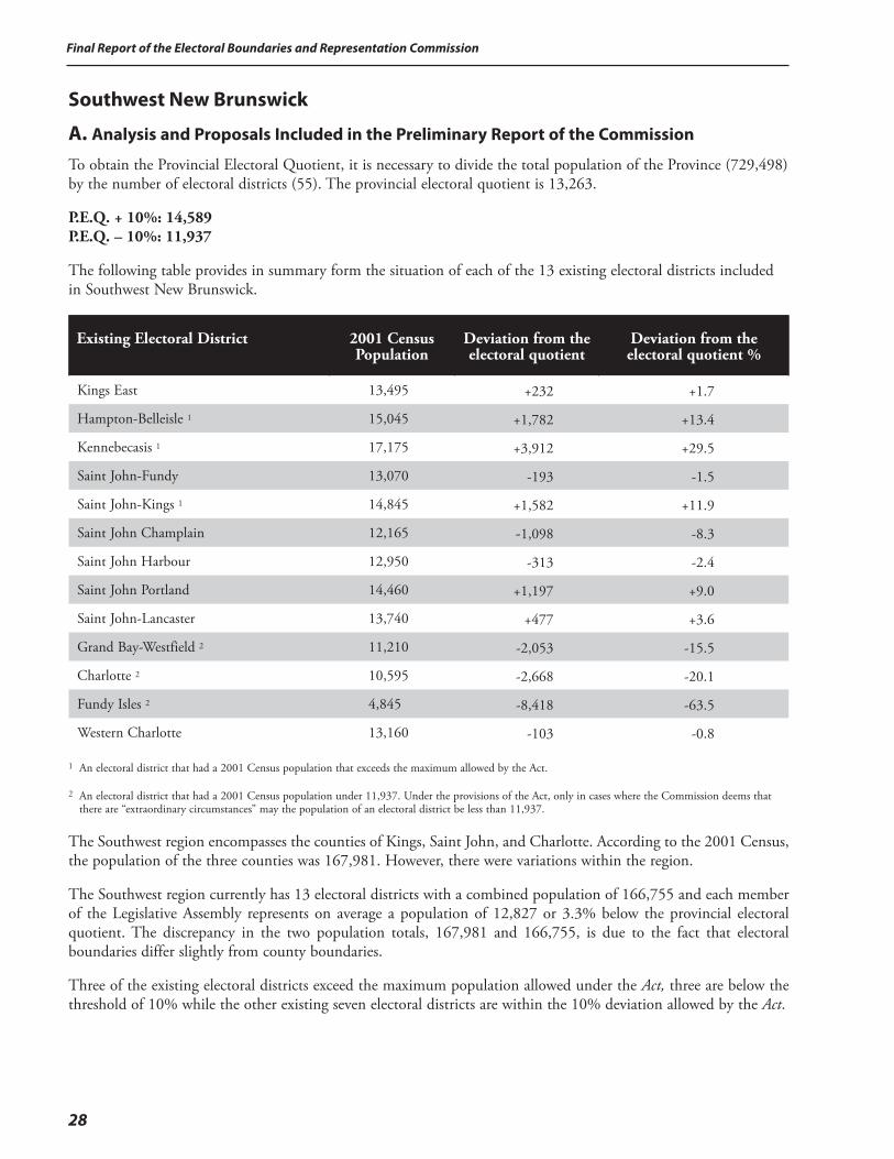
Final Report of the Electoral Boundaries and Representation Commission
28
Southwest New Brunswick
A. Analysis and Proposals Included in the Preliminary Report of the Commission
To obtain the Provincial Electoral Quotient, it is necessary to divide the total population of the Province (729,498) by the number of electoral districts (55). The provincial electoral quotient is 13,263.
P.E.Q. + 10%: 14,589 P.E.Q. – 10%: 11,937
The following table provides in summary form the situation of each of the 13 existing electoral districts included in Southwest New Brunswick.
Existing Electoral District
2001 Census Population
Deviation from the electoral quotient
Deviation from the electoral quotient %
Kings East 13,495 +232 +1.7
Hampton-Belleisle 1 15,045 +1,782 +13.4
Kennebecasis 1 17,175 +3,912 +29.5
Saint John-Fundy 13,070 -193 -1.5
Saint John-Kings 1 14,845 +1,582 +11.9
Saint John Champlain 12,165 -1,098 -8.3
Saint John Harbour 12,950 -313 -2.4
Saint John Portland 14,460 +1,197 +9.0
Saint John-Lancaster 13,740 +477 +3.6
Grand Bay-Westfield 2 11,210 -2,053 -15.5
Charlotte 2 10,595 -2,668 -20.1
Fundy Isles 2 4,845 -8,418 -63.5
Western Charlotte 13,160 -103 -0.8
1 An electoral district that had a 2001 Census population that exceeds the maximum allowed by the Act.
2 An electoral district that had a 2001 Census population under 11,937. Under the provisions of the Act, only in cases where the Commission deems that there are “extraordinary circumstances” may the population of an electoral district be less than 11,937.
The Southwest region encompasses the counties of Kings, Saint John, and Charlotte. According to the 2001 Census, the population of the three counties was 167,981. However, there were variations within the region.
The Southwest region currently has 13 electoral districts with a combined population of 166,755 and each member of the Legislative Assembly represents on average a population of 12,827 or 3.3% below the provincial electoral quotient. The discrepancy in the two population totals, 167,981 and 166,755, is due to the fact that electoral boundaries differ slightly from county boundaries.
Three of the existing electoral districts exceed the maximum population allowed under the Act, three are below the threshold of 10% while the other existing seven electoral districts are within the 10% deviation allowed by the Act.
29
Final Report of the Electoral Boundaries and Representation Commission
General Approach
The Commission used the following guidelines in proposing the new boundaries for the Southwest New Brunswick region: • The three neighbouring electoral districts of Hampton-Belleisle, Kennebecasis and Saint John-Kings all
exceed the maximum population allowed of 14,589. The combined population of the three electoral districts is 47,065. There is insufficient population to create a new electoral district. Therefore, the Commission will have to apportion the excess population in adjoining electoral districts. This course of action will necessarily bring about changes in the boundaries of electoral districts that are currently within the 10% deviation allowed by the Act.
Electoral District #28 – Kings EastThe existing Kings East electoral district had a 2001 Census population of 13,495, or 1.7% above the provincial electoral quotient. While this number is within the guidelines laid out in the Act, the Commission proposes to make the following changes in order to enable other districts to conform to the Act. The Commission proposes to transfer the following communities from the Kings East district to the Petitcodiac district: • Head of Millstream, Carsonville and Summerfield.
The Commission also proposes to transfer the following municipality from the Hampton-Belleisle electoral district to the Kings East electoral district: • the Village of Norton.
The effect of the transfers would be to increase the population of the proposed electoral district of Kings East from 13,495 to 14,515 or 9.4% over the provincial electoral quotient.
Electoral District #29 – Hampton-BelleisleThe existing Hampton-Belleisle electoral district had a 2001 Census population of 15,045, or 13.4% above the provincial electoral quotient. The current situation does not meet the requirements of the Act. The Commission proposes to transfer the following municipality from the Hampton-Belleisle electoral district to the Kings East electoral district: • the Village of Norton.
The Commission proposes to transfer from the Saint John-Fundy electoral district to the Hampton-Belleisle electoral district the following communities: • Grove Hill, Hanford Brook and the remaining portion of Barnesville.
The Commission also proposes to transfer from the Kennebecasis electoral district, the following: • the area north of Hammond River.
The effect of the transfers would be to decrease the population of the proposed electoral district of Hampton-Belleisle from 15,045 to 14,470 or 9.1% over the provincial electoral quotient.
Electoral District #30 – QuispamsisThe existing Kennebecasis electoral district had a 2001 Census population of 17,175 or 29.5% above the provincial electoral quotient. The current situation does not meet the requirements of the Act. The Commission is proposing to have the boundaries of the electoral district coincide with the boundaries of the municipality of Quispamsis. The following area would be transferred from the Kennebecasis electoral district to the Hampton-Belleisle electoral district: • the French Village area.
The Commission is also proposing to transfer the following areas to Rothesay-Kings: • Damascus and Smithtown.
Final Report of the Electoral Boundaries and Representation Commission
30
The effect of the transfers would be to decrease the population of the proposed electoral district of Quispamsis from 17,175 to 13,757 or 3.7% over the provincial electoral quotient. The Commission is also proposing to change the name of the electoral district from Kennebecasis to Quispamsis.
Electoral District #31 – Saint John-FundyThe existing Saint John-Fundy electoral district had a 2001 Census population of 13,070 or 1.5% below the provincial electoral quotient. While this number is within the guidelines laid out in the Act, the Commission proposes to make the following changes in order to enable other electoral districts to conform to the Act.
The Commission is proposing to transfer to Saint John-Fundy from Rothesay-Kings the following areas: • the area north of Golden Grove Road and south of the MacKay Highway.
The effect of the transfers would be to increase the population of the proposed electoral district of Saint John-Fundy from 13,070 to 13,888 or 4.7% over the provincial electoral quotient.
Electoral District #32 – Rothesay-KingsThe existing Saint John-Kings electoral district had a 2001 Census population of 14,845 or 11.9% above the electoral quotient and consequently, the population in the electoral district must be reduced.
The Commission proposes to transfer the following area from the Saint John-Kings electoral district to the Saint John East electoral district: • the area in The City of Saint John south of the Golden Grove Road including Forest Hills.
The Commission proposes to transfer the following area from the Saint John-Kings electoral district to the Saint John-Fundy electoral district: • the area north of the Golden Grove Road and south of the McKay Highway.
The effect of the transfers would be to decrease the population of the proposed electoral districts of Rothesay-Kings from 14,845 to 13,434 or 1.3% over the provincial electoral quotient. The Commission is also proposing to change the name of the electoral district from Saint John-Kings to Rothesay-Kings.
Electoral District #33 – Saint John EastThe existing Saint John Champlain electoral district had a 2001 Census population of 12,165 or 8.3% below the provincial electoral quotient. While this number is within the guidelines laid out in the Act, the Commission proposes to make the following changes in order to enable other electoral districts to conform to the Act. The Commission proposes to transfer the following area from the Rothesay-Kings electoral district to the Saint John Champlain electoral district: • the area in The City of Saint John south of the Golden Grove Road including Forest Hills.
The Commission also proposes to transfer the following from the Saint John Champlain electoral district to the Saint John Harbour electoral district: • part of the area located north of the throughway formerly known as the Valley.
The effect of the transfers would be to increase the population of the proposed electoral district of Saint John East from 12,165 to 14,245 or 7.4% over the provincial electoral quotient. The Commission is also proposing to change the name of the electoral district from Saint John Champlain to Saint John East.
Electoral District #34 - Saint John HarbourThe existing Saint John Harbour electoral district had a 2001 Census population of 12,950 or 2.4% below the provincial electoral quotient. While this number is within the guidelines laid out in the Act, the Commission proposes to make the following changes in order to enable other electoral districts to conform to the Act:
31
Final Report of the Electoral Boundaries and Representation Commission
The Commission proposes to transfer from the Saint John Champlain electoral district to the Saint John Harbour electoral district: • part of the area located north of the throughway formerly known as the Valley.
The effect of the transfer would be to increase the population of the proposed electoral district of Saint John Harbour from 12,950 to 14,107 or 6.4% over the provincial electoral quotient. (In the final report, the Commission decided to make a minor adjustment to the boundary between Saint John Portland and Saint John Harbour. It deletes portions of Cedar Street, Albert Street and Main Street from Saint John Harbour and ads them to Saint John Portland.)
Electoral District #35 – Saint John PortlandThe existing Saint John Portland electoral district had a 2001 Census population of 14,460 or 9.0% above the provincial electoral quotient. The Commission is not proposing any changes to the boundaries of the electoral district of Saint John Portland as it is within the provisions of the Act. (In the final report, the Commission decided to make a minor adjustment to the boundary between Saint John Portland and Saint John Harbour. It deletes portions of Cedar Street, Albert Street and Main Street from Saint John Harbour and ads them to Saint John Portland.)
Electoral District #36 – Saint John LancasterThe existing Saint John Lancaster electoral district had a 2001 Census population of 13,740 or 3.6% above the provincial electoral quotient. The Commission is not proposing any changes to the boundaries of the electoral district of Saint John Lancaster as it is within the provisions of the Act.
Electoral District #37 – Grand Bay-WestfieldThe existing Grand Bay-Westfield electoral district had a 2001 Census population of 11,210 or 15.5% below the provincial electoral quotient. The current situation does not meet the requirements of the Act. The Commission is proposing to transfer the following areas from the Charlotte electoral district to the Grand Bay-Westfield electoral district: • the Parish of Musquash; • Maces Bay and Little Lepreau.
The effect of the transfers would be to increase the population of the proposed electoral district of Grand Bay-Westfield from 11,210 to 12,919 or 2.6% below the provincial electoral quotient.
General Approach
Charlotte County currently has three electoral districts one of which, the Charlotte electoral district, includes the parish of Musquash from Saint John County. Western Charlotte is the only electoral district of the three that has a population that meets the requirements of the Act. Fundy Isles with a population of 4,845 is 63.5% below the provincial electoral quotient of 13,263 while Charlotte is 20.1% below the quotient at 10,995.
The Commission is proposing to return the parish of Musquash to the electoral district of Grand Bay-Westfield in order to bring the population of this electoral district to an acceptable level. This transfer would have the effect that the Charlotte electoral district would then be in the range of 30% below the electoral quotient. Western Charlotte, with a population of 13,160 or 0.8% below the electoral quotient, does not have enough population that could be transferred to the Charlotte electoral district to bring the latter into conformity with the Act. The Commission then considered keeping Musquash in Charlotte and look for another option for Grand Bay-Westfield. Even if the parish of Musquash were to remain in the Charlotte electoral district, the numbers would still not be adequate. Under the circumstances, the only way in which the Commission could maintain the three existing electoral districts would be to invoke the “extraordinary circumstances” provision of the Act for two of the three Charlotte electoral districts.
Final Report of the Electoral Boundaries and Representation Commission
32
Prior to 1974, the islands in the Bay of Fundy were part of the Charlotte County electoral district that sent four members to the Legislative Assembly. With the advent of single member electoral districts prior to the 1974 election, the islands became part of three separate electoral districts, i.e. St. Stephen-Milltown, Charlotte Centre and Charlotte-Fundy. The existing electoral district of Fundy Isles was only created prior to the 1995 election.
The Commission considered the question of access to the islands: • the only year-round public transportation link from Campobello is by bridge to the State of Maine and then
by highway to St. Stephen;
• the access to Grand Manan is by a year-round ferry service from Black’s Harbour;
• a separate ferry service provides access to Deer Island from Letete;
• there is no public transportation linking the islands with each other (a private ferry service operates between Deer Island and Campobello but only in the summer months).
Public access from one island to another is via the mainland in all cases. Consequently, it is actually easier for the resident of any given island to consult a member of the Legislative Assembly on the mainland than it is to consult a member of the Legislative Assembly who resides on a different island. The Commission, therefore, believes that effective representation can in some respects be better achieved by combining the islands with nearby mainland electoral districts.
The Commission also considered the community of interest that exists among the islands and mainland Charlotte County through the fishing and aquaculture industries. Accordingly, a viable option exists for effective representation without invoking the “extraordinary circumstances” provision of the Act.
The Commission is proposing to transfer the following areas from the existing Charlotte electoral district to the Grand Bay-Westfield electoral district: • the Parish of Musquash; • Maces Bay and Little Lepreau.
The Commission is proposing to establish two electoral districts in the Charlotte region:
Electoral District #38 – Charlotte-The IslesThe proposed electoral district of Charlotte-The Isles would consist of: • the remaining portion of the existing Charlotte electoral district; • Grand Manan Island; • Deer Island; • White Head Island; • the community of Leverville and a portion of Honeydale currently in the existing Western Charlotte
electoral district.
The effect of the proposal would be to create an electoral district with a population of 12,972 or 2.2% below the provincial electoral quotient. The Commission is proposing that the proposed electoral district be named Charlotte-The Isles.
Electoral District #39 – Charlotte-CampobelloThe proposed electoral district of Charlotte-Campobello would consist of: • the remaining portion of the existing Western Charlotte electoral district; • Campobello Island.The effect of the proposal would be to create an electoral district with a population of 13,918 or 4.9% over the provincial electoral quotient. The Commission is also proposing that the proposed electoral district be named Charlotte-Campobello.
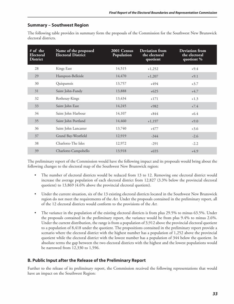
33
Final Report of the Electoral Boundaries and Representation Commission
Summary – Southwest Region
The following table provides in summary form the proposals of the Commission for the Southwest New Brunswick electoral districts.
# of the Electoral District
Name of the proposed Electoral District
2001 Census Population
Deviation from
the electoral quotient
Deviation from
the electoral quotient %
28 Kings East 14,515 +1,252 +9.4
29 Hampton-Belleisle 14,470 +1,207 +9.1
30 Quispamsis 13,757 +494 +3.7
31 Saint John-Fundy 13,888 +625 +4.7
32 Rothesay-Kings 13,434 +171 +1.3
33 Saint John East 14,245 +982 +7.4
34 Saint John Harbour 14,107 +844 +6.4
35 Saint John Portland 14,460 +1,197 +9.0
36 Saint John Lancaster 13,740 +477 +3.6
37 Grand Bay-Westfield 12,919 -344 -2.6
38 Charlotte-The Isles 12,972 -291 -2.2
39 Charlotte-Campobello 13,918 +655 +4.9
The preliminary report of the Commission would have the following impact and its proposals would bring about the following changes to the electoral map of the Southwest New Brunswick region:
• The number of electoral districts would be reduced from 13 to 12. Removing one electoral district would increase the average population of each electoral district from 12,827 (3.3% below the provincial electoral quotient) to 13,869 (4.6% above the provincial electoral quotient).
• Under the current situation, six of the 13 existing electoral districts located in the Southwest New Brunswick region do not meet the requirements of the Act. Under the proposals contained in the preliminary report, all of the 12 electoral districts would conform to the provisions of the Act.
• The variance in the population of the existing electoral districts is from plus 29.5% to minus 63.5%. Under the proposals contained in the preliminary report, the variance would be from plus 9.4% to minus 2.6%. Under the current distribution, the range is from a population of 3,912 above the provincial electoral quotient to a population of 8,418 under the quotient. The propositions contained in the preliminary report provide a scenario where the electoral district with the highest number has a population of 1,252 above the provincial quotient while the electoral district with the lowest number has a population of 344 below the quotient. In absolute terms the gap between the two electoral districts with the highest and the lowest populations would be narrowed from 12,330 to 1,596.
B. Public Input after the Release of the Preliminary Report
Further to the release of its preliminary report, the Commission received the following representations that would have an impact on the Southwest Region:

Final Report of the Electoral Boundaries and Representation Commission
34
1. In order to create the required new seats in Central and Southeastern New Brunswick, the Commission should have eliminated two seats in Northern New Brunswick instead of one in the North and one in the Southwest.
2. The village of Norton should continue to be part of the electoral district of Hampton-Belleisle and not be transferred to the proposed electoral district of Kings East.
3. The Golden Grove Road area from the Hillcrest Road to the Kings County line should remain in the electoral district of Saint John Fundy.
4. The Commission is proposing to change the name of the existing electoral district of Saint John Kings to Rothesay-Kings. Instead the name of the electoral district should be Rothesay.
5. The parish of Musquash should remain in the proposed electoral district of Charlotte-The Isles and not be transferred to the electoral district of Grand Bay-Westfield.
C. Response to the Public Input and Recommendations of the Commission for the Southwest New Brunswick Region
In arriving at its decisions concerning the electoral districts of Southwest New Brunswick, the Commission reviewed carefully the representations it received at the public hearings and by correspondence sent to the office of the Commission. The representations were also reviewed in the context of the preceding regional analysis of this report.
Public Input:1. In order to create the required new seats in Central and Southeastern New Brunswick, the Commission should have
eliminated two seats in Northern New Brunswick instead of one in the North and one in the Southwest.
Response of the Commission:As the table below indicates, of the five regions in the Province, it is the Northwest and the Southwest regions that have the lowest ratios of population per member of the Legislative Assembly. Moreover, the Southwest region is the most urbanized region in the Province and, for reasons indicated elsewhere in this report, the Commission believes that electoral districts in urban areas should have higher average populations than electoral districts in rural areas.
Region
Total Population
Total MLAs
Population per MLA
% Urban
Population
Northeast 169,880 13 13,068 36.2
Northwest 83,967 7 11,995 37.7
Central 124,850 8 15,606 52.7
Southeast 182,820 14 13,059 57.3
Southwest 167,981 13 12,922 62.0
Source: Statistics Canada, 2001 Census
When the Commission reviewed the population data from the 2001 Census, it found eight contiguous electoral districts in the Northeast and the Northwest regions all below the threshold with a population of less than 11,937. The total population for the eight electoral districts is 93,995 for an average population of 11,749 representing 11.4% below the electoral quotient of 13,263. The Commission also found three contiguous electoral districts in the Southwest region with a total population of 26,289 for an average population of 8,763 representing 33.9% below the electoral quotient. It is on this basis that the Commission proposed in its preliminary report to eliminate one electoral district in Northern New Brunswick and another in the Southwest region of the Province. After careful analysis of the statistical data and a thorough review of all the representations received, the Commission reaffirms that it will recommend that one electoral district be eliminated in each of the two areas mentioned.
35
Final Report of the Electoral Boundaries and Representation Commission
Public Input: 2. The village of Norton should continue to be part of the electoral district of Hampton-Belleisle and not be transferred
to the proposed electoral district of Kings East.
Response of the Commission:The Commission reviewed carefully the request to leave the village of Norton in the proposed electoral district of Hampton-Belleisle. This request would trigger significant changes in other proposed electoral districts, the residents of which would have no opportunity to have input to the Commission on such changes since they would only become aware of them in the final report of the Commission. According to one of the representations received, the electoral districts of Petitcodiac, Kings East, Hampton-Belleisle, Grand Bay-Westfield, Charlotte-The Isles and Charlotte-Campobello would need to have their boundaries changed, in some cases significantly. A probable result of such a realignment would be to divide the rural Kingston Peninsula into two separate electoral districts. The Commission had considered this option during the preparation of its preliminary report but rejected it on the grounds that it would be desirable to keep all the residents of the Kingston Peninsula in the same electoral district. In light of the representations received, the Commission re-examined the issue and found no compelling reasons to change its original proposal. Consequently, the Commission is not able to accede to the request to have the village of Norton remain in the electoral district of Hampton-Belleisle.
Public Input: 3. The Golden Grove Road area from the Hillcrest Road to the Kings County line should remain in the electoral district
of Saint John Fundy.
Response of the Commission:The Commission will recommend that the portion of the Golden Grove Road from the Hillcrest Road to the Airport Access Road and its adjoining roads remain in the electoral district of Saint John Fundy. That part of the Golden Grove Road to the east of the Airport Access Road will be transferred to the electoral district of Rothesay-Kings, will be named Rothesay, since it serves as a connector between the town of Rothesay and the more rural portion of the electoral district to the east.
Public Input: 4. The Commission is proposing to change the name of the existing electoral district of Saint John Kings to Rothesay-Kings.
Instead the name of the electoral district should be Rothesay.
Response of the Commission:The Commission agrees.
Public Input: 5. The parish of Musquash should remain in the proposed electoral district of Charlotte-The Isles and not be transferred
to the electoral district of Grand Bay-Westfield.
Response of the Commission:The Commission concluded in the preparation of its preliminary report that the preferred option to bring the electoral district of Grand Bay-Westfield in conformity with the provisions of the Act, was to transfer the parish of Musquash to that electoral district. After having considered the alternative proposal put forward at the public hearing, the Commission maintains its original proposal and will recommend that the parish of Musquash be transferred to the electoral district of Grand Bay-Westfield.
Note: The names of the electoral districts form part of the final report of the Commission. However, the names may be amended by the Lieutenant-Governor-in-Council on the recommendation of the Legislative Administrative Committee.
Final Report of the Electoral Boundaries and Representation Commission
36
Northwest New Brunswick
A. Analysis and Proposals Included in the Preliminary Report of the Commission
To obtain the Provincial Electoral Quotient, it is necessary to divide the total population of the Province (729,498) by the number of electoral districts (55). The provincial electoral quotient is 13,263.
P.E.Q. + 10%: 14,589 P.E.Q. – 10%: 11,937
The following table provides in summary form the situation of each of the seven existing electoral districts included in Northwest New Brunswick.
Existing Electoral District
2001 Census Population
Deviation from the electoral quotient
Deviation from the electoral quotient %
Woodstock 1 14,590 +1,327 +10.0
Carleton 13,990 +727 +5.5
Victoria-Tobique 2 11,495 -1,768 -13.3
Grand Falls Region 2 11,865 -1,398 -10.5
Madawaska-la-Vallée 2 10,675 -2,588 -19.5
Edmundston 2 10,840 -2,423 -18.3
Madawaska-les-Lacs 2 11,910 -1,353 -10.2
1 An electoral district that had a 2001 Census population that exceeds the maximum allowed by the Act.
2 An electoral district that had a 2001 Census population under 11,937. Under the provisions of the Act, only in cases where the Commission deems that there are “extraordinary circumstances” may the population of an electoral district be less than 11,937.
The Northwest region of New Brunswick encompasses the counties of Madawaska, Victoria and Carleton. According to the 2001 Census, the population of the three counties was 83,967. The Northwest region currently has seven electoral districts with a combined population of 85,365. Each member of the Legislative Assembly represents on average a population of 12,195, or 8.1% below the provincial electoral quotient. The discrepancy in the two population totals, 83,967 and 85,365, is due to the fact that electoral boundaries differ slightly from county boundaries.
The electoral district of Woodstock exceeds the maximum population allowed. The population of each of the five most northern electoral districts of the region is below the threshold of 11,937. The electoral district of Carleton is the only electoral district within the guidelines set out in the Act. In summary, six of the seven existing electoral districts in Northwest New Brunswick need boundary changes. The fact that five electoral districts located next to each other are all below the threshold means that it will be difficult, if not impossible, for the Commission to bring these electoral districts into conformity with the provisions of the Act while maintaining the same number of electoral districts. The situation is further compounded by the fact that the three neighbouring electoral districts to the east in Restigouche County are also below the acceptable threshold of 11,937.
Effective Representation of the English and French Linguistic Communities
One of the considerations that the Commission is required to take into account while determining electoral boundaries is the effective representation of the English and French linguistic communities. While Northwest New Brunswick may present a number of common economic characteristics throughout the region, there is a significant difference in terms of the northern and southern portions of the region when it comes to language.
37
Final Report of the Electoral Boundaries and Representation Commission
For instance, the mother tongue of the population of the electoral districts of Woodstock, Carleton and Victoria-Tobique is predominately English, ranging from 86% in Victoria-Tobique to 97% in both Carleton and Woodstock. In the case of the population of the four electoral districts from the Grand Falls Region to the Quebec border, the mother tongue is predominately French, varying from 84% in the Grand Falls Region electoral district to 96% in the Madawaska-les-Lacs electoral district.
The following table demonstrates the mother tongue of the electoral district of Northwest New Brunswick as reported in the 2001 Census:
Electoral District
English (%)
French (%)
Other (%)
Woodstock 97 1 1Carleton 97 2 1Victoria-Tobique 86 9 5Grand Falls Region 14 84 2Madawaska-la-Vallée 4 95 1Edmundston 6 91 3Madawaska-les-Lacs 4 96 1
The electoral redistributions of 1973 and 1993 seemed to establish, as best as possible, a natural linguistic boundary between the more Anglophone electoral districts to the south and the more Francophone electoral districts to the north.
In preparing its proposals to redraw the boundaries of the electoral districts of the Northwest region, the Commission will, therefore, consider the three primarily Anglophone southern electoral districts as a unit and the four primarily Francophone northern electoral districts as a separate unit.
Primarily Anglophone Electoral Districts
Electoral District #49 – WoodstockThe existing Woodstock electoral district had a 2001 Census population of 14,590. This number is just higher than the prescribed electoral quotient and consequently, the population in the electoral district must be reduced. While it is only slightly above the 10%, the Commission is of the view that the population of this electoral district should be much closer to the provincial electoral quotient, especially in view of the rural nature of the electoral district. The Commission proposes to return the York County portion currently in the Woodstock electoral district to the York electoral district. The transfer would include: • the village of Canterbury and the village of Meductic; • the parishes of Canterbury and North Lake.
The effect of the transfers would be to decrease the population of the proposed Woodstock electoral district from 14,590 to 13,197 or 0.5% below the provincial electoral quotient.
Electoral District #50 – CarletonThe existing Carleton electoral district had a 2001 Census population of 13,990, or 5.5% above the provincial electoral quotient. While the current situation is within the guidelines laid out in the Act, the population is at the high end of the scale for a rural electoral district. The Commission is proposing to transfer the following portion of the Carleton electoral district to the Victoria-Tobique electoral district: • the area that is located east of the Saint John River and north of the Monquart Stream.
The effect of the transfer would be to decrease the population of the proposed Carleton electoral district from 13,990 to 12,491 or 5.8 below the provincial electoral quotient.
Final Report of the Electoral Boundaries and Representation Commission
38
Electoral District #51 – Victoria-TobiqueThe existing Victoria-Tobique electoral district had a 2001 Census population of 11,495, or 13.3% below the provincial electoral quotient. The current situation does not meet the requirements of the Act. The Commission is proposing to transfer the following portion of the Carleton electoral district to the Victoria-Tobique electoral district: • the area that is located east of the Saint John River and north of the Monquart Stream.
Due to the community of interest factor, the Commission is also proposing to transfer the following portion of the Grand Falls Region electoral district to the Victoria-Tobique electoral district: • the portion of California Settlement currently located in the Grand Falls Region electoral district.
The effect of the transfers would be to increase the population of the proposed Victoria-Tobique electoral district from 11,495 to 13,137 or 1.0% below the provincial electoral quotient.
Primarily Francophone Electoral Districts
Madawaska-les-Lacs, Edmundston, Madawaska-la-Vallée, Grand Falls RegionThe four existing electoral districts of Madawaska-les-Lacs, Edmundston, Madawaska-la-Vallée and the Grand Falls Region all deviate by more than 10% below the provincial electoral quotient. The range is from minus 10.2% in Madawaska-les-Lacs to minus 19.5% in Madawaska-la-Vallée. Under the current situation none of the four electoral districts meet the guidelines of the Act. Since all four electoral districts are more than 10% below the electoral quotient, it is impossible to bring them into conformity by simply shifting boundaries among the four. The combined population of the four electoral districts is 45,290, giving an average population of 11,322 or 14.6% below the provincial electoral quotient. The Commission looked at the following three options:
1. Make three electoral districts out of the existing four. As stated, the combined population of the four electoral districts is 45,290. Three proposed electoral districts would have an average population of 15,097 or 13.8% above the provincial electoral quotient. This option is clearly not acceptable under the terms of the Act.
2. Add Victoria-Tobique to the other four electoral districts in order to make four electoral districts out of the previous five. The total population of the five electoral districts would be 56,785. Dividing that total by four would yield an average population of 14,196 or 7% over the provincial electoral quotient. There are two issues with this option. The first is that 7% over the provincial electoral quotient is relatively high for a rural area. The second issue relates to the effective representation of the English and French linguistic communities since one electoral district would combine the largely Anglophone electoral district of Victoria-Tobique with a portion of the largely Francophone electoral district of the Grand Falls electoral district. In any case, the Commission has found another solution to increase the population of Victoria-Tobique by transferring part of the Carleton electoral district.
3. Combine the four mainly Francophone electoral districts with part of the Restigouche West electoral district in order to have four electoral districts that meet the requirements of the Act.
The Commission is proposing to select Option 3.
As explained in previous portions of this report, the Commission had to add two electoral districts elsewhere in the Province because of the over-population of certain regions. There are two reasons for this course of action. Firstly, the provisions of the Act are more restrictive than the rules under which the 1991-1993 Commission operated (10% maximum deviation versus 25% in 1993). Secondly, there have been population shifts from 1991 to 2001: some regions have grown in population while others have declined. Since the Act makes it mandatory for the Commission to maintain the number of electoral districts constant at 55, the obvious conclusion is that for every electoral district added, another electoral district has to be eliminated.
When the Commission reviewed the status of individual electoral districts throughout the Province, it found that eight adjoining electoral districts were all under the 10% threshold allowed by the Act: two in Victoria County, three in Madawaska and three in Restigouche. Under the circumstances, it was impossible to rearrange the boundaries of
39
Final Report of the Electoral Boundaries and Representation Commission
the eight electoral districts and have them conform to the provisions of the Act. Nor did the Commission feel that invoking the “extraordinary circumstances” clause of the Act was warranted in the present circumstances since the issue appeared to be simply one of under-population. Therefore, the Commission proposes to consider the primarily Francophone electoral districts of Grand Falls Region, Madawaska, and the western portion of Restigouche West as a unit when arriving at its proposals for the area.
The proposal of the Commission would mean that Northwest New Brunswick would share an electoral district with Northeast New Brunswick instead of losing a complete electoral district.
Electoral District #52 – Grand Falls The existing Grand Falls Region electoral district had a 2001 Census population of 11,865, or 10.5% below the provincial electoral quotient of 13,263. The current situation does not meet the requirements of the Act.
Due to the community of interest factor, the Commission is proposing to transfer the following portion of the Grand Falls Region electoral district to the Victoria-Tobique electoral district: • the portion of California Settlement currently located in the Grand Falls Region electoral district.
The Commission is also proposing to transfer the following portion of the Madawaska-la-Vallée electoral district to the Grand Falls Region electoral district: • the rural area southeast of Saint-Léonard.
The effect of the transfers would be to increase the population of the proposed Grand Falls electoral district from 11,865 to 12,411 or 6.4% below the provincial electoral quotient. The Commission also proposes to change the name of the electoral district from Grand Falls Region to Grand Falls.
Electoral District #53 – Madawaska-RestigoucheThe Commission is proposing the creation of a new electoral district to include a part of the existing electoral districts of Madawaska-la-Vallée and Restigouche West. The proposed electoral district would include the following areas from Restigouche West: • the town of Saint Quentin; • the village of Kedgwick; • the parishes of Saint Quentin and Grimmer; • the western portion of the parish of Eldon.
The proposed electoral district would include the existing electoral district of Madawaska-la-Vallée, less the following areas that the Commission proposes to transfer to other electoral districts: • the area formerly known as the village of Saint-Basile (now part of the city of Edmundston) to the
electoral district of Edmundston;
• the parish of Saint-Basile to the Madawaska-les-Lacs electoral district;
• the rural area southeast of Saint-Léonard to the Grand Falls electoral district.
The proposed electoral district would have a population of 12,715 or 4.1% below the provincial electoral quotient. The Commission is proposing that the proposed electoral district be known as Madawaska-Restigouche.
Electoral District #54 – Edmundston-Saint-BasileThe existing Edmundston electoral district had a 2001 Census population of 10,840, or 13.3% below the provincial electoral quotient. The current situation does not meet the requirements of the Act. The Commission is proposing to transfer the following portion of the Madawaska-la-Vallée electoral district to the Edmundston electoral district: • the area formerly known as the village of Saint-Basile (now part of the city of Edmundston)

Final Report of the Electoral Boundaries and Representation Commission
40
The effect of the transfer would be to increase the population of the proposed electoral district of Edmundston from 10,840 to 13,983 or 5.4% above the provincial electoral quotient. The Commission is also proposing to change the name of the electoral district from Edmundston to Edmundston-Saint-Basile.
Electoral District #55 – Madawaska-les-LacsThe existing Madawaska-les-Lacs electoral district had a 2001 Census population of 11,910, or 10.2% below the provincial electoral quotient. The current situation does not meet the requirements of the Act. The Commission is proposing to transfer the following area from the Madawaska-la-Vallée electoral district to the Madawaska-les-Lacs electoral district: • the parish of Saint-Basile.
The effect of the transfer would be to increase the population of the proposed electoral district of Madaswaska-les-Lacs from 11,910 to 12,615 or 4.9% below the provincial electoral quotient.
Summary – Northwest Region
The following table provides in summary form the proposals of the Commission for the seven Northwest New Brunswick electoral districts.
# of the Electoral District
Name of the proposed Electoral District
2001 Census Population
Deviation from the electoral
quotient
Deviation from the electoral quotient %
49 Woodstock 13,197 -66 -0.550 Carleton 12,491 -772 -5.851 Victoria-Tobique 13,137 -126 -1.052 Grand Falls 12,411 -852 -6.453 Madawaska-Restigouche 12,715 -548 -4.154 Edmundston-Saint-Basile 13,983 +720 +5.455 Madawaska-les-Lacs 12,615 -648 -4.9
The preliminary report of the Commission would have the following impact and its proposals would bring about the following changes to the electoral map of the Northwest New Brunswick region :
• There are currently seven electoral districts in the region. Under the proposals of the Commission, one of the electoral districts, Madawaska-Restigouche, would be shared between the Northwest and the Northeast regions. The changes would increase the average population of each electoral district from 12,195 (8.1% below the provincial electoral quotient) to 12,936 (2.5% below the provincial electoral quotient).
• Under the current situation, six of the seven electoral districts located in the Northwest New Brunswick region do not meet the requirements of the Act. Under the proposals contained in the preliminary report, all of the seven electoral districts (including the one shared with the Northeast) would conform to the provisions of the Act.
• The variance in the population of the existing electoral districts is from plus 10% to minus 19.5%. Under the proposals contained in the preliminary report, the variance would be from plus 5.4% to minus 6.4%. Under the current distribution, the range is from a population of 1,327 above the provincial electoral quotient to a population of 2,588 under the quotient. The propositions contained in the preliminary report provide a scenario where the electoral district with the highest number has a population of 720 above the provincial quotient while the electoral district with the lowest number has a population of 852 below the quotient. In absolute terms the gap between the two electoral districts with the highest and the lowest populations would be narrowed from 3,915 to 1,572.
41
Final Report of the Electoral Boundaries and Representation Commission
B. Public Input after the Release of the Preliminary Report
Further to the release of its preliminary report, the Commission received the following representations that would have an impact on the Northwest region:
1. The portion of York County in the existing electoral district of Woodstock should not be transferred to the proposed electoral district of York.
2. The area of Carleton County east of the Saint John River and north of the Monquart Stream should not be transferred to the proposed electoral district of Victoria-Tobique.
3. The area of Saint-Léonard-Parent should be transferred from the proposed Grand Falls electoral district to the proposed Madawaska-Restigouche electoral district.
4. The existing electoral district of Restigouche West should remain intact and a portion of that electoral district should not be merged with a portion of the existing electoral district of Madawaska-la-Vallée to form the electoral district of Madawaska-Restigouche as proposed by the Commission.
5. Saint-Jacques and Verret have been amalgamated with Edmundston and should therefore be part of the electoral district of Edmundston.
6. All of Mount Carleton Provincial Park should be included in the proposed electoral district of Madawaska-Restigouche.
7. The existing electoral district of the Grand Falls Region should not be renamed Grand Falls as proposed by the Commission. The name of the proposed electoral district should be Drummond-Grand Falls-Saint-André.
8. The name of the electoral district should be Restigouche-La-Vallée instead of Madawaska-Restigouche as proposed by the Commission.
C. Response to the Public Input and Recommendations of the Commission for the Northwest New Brunswick Region
In arriving at its decisions concerning the electoral districts of Northwest New Brunswick, the Commission reviewed carefully the representations it received at the public hearings and by correspondence sent to the office of the Commission. The representations were also reviewed in the context of the preceding regional analysis of this report.
Public Input:1. The portion of York County in the existing electoral district of Woodstock should not be transferred to the proposed
electoral district of York.
Response of the Commission:In its preliminary report, the Commission proposed to transfer the portion of York County located in the existing electoral district of Woodstock to the proposed electoral district of York. The reason for the proposal was to correct the overpopulation of the electoral district of Woodstock that currently exceeds the 10% deviation allowed by the Act. Based on the representations received, the Commission has been persuaded that the community of interest factor would best be served if the portion of York County in the existing Woodstock electoral district were to continue to be part of the proposed electoral district of Woodstock. This area consists of the villages of Canterbury and Meductic and the parishes of Canterbury and North Lake.
Final Report of the Electoral Boundaries and Representation Commission
42
The Commission has to take into account the impact that the transfer will have on both electoral districts of York and Woodstock. The effect on the proposed electoral district of York is to decrease its population from 14,116 to 12,723 or 4.1% below the electoral quotient. The Commission considers this situation acceptable, given the relatively rural nature of the electoral district. The effect on the proposed electoral district of Woodstock is to leave its population unchanged at 14,590, a number not acceptable under the Act. To remedy this situation, the Commission will transfer the parts of the communities of Wilmot, Avondale, Deerville and Weston currently located in the Woodstock electoral district to the Carleton electoral district. This transfer involves a population of 71 and will have the advantage of reuniting the communities that are currently split into two separate electoral districts.
Public Input:2. The area of Carleton County east of the Saint John River and north of the Monquart Stream should not be transferred
to the proposed electoral district of Victoria-Tobique.
Response of the Commission:The proposal in the preliminary report of the Commission would have had the effect of transferring a population of 1,499 from the proposed electoral district of Carleton to the proposed electoral district of Victoria-Tobique. The electoral district of Carleton would have had a population of 12,491 while the population of the electoral district of Victoria-Tobique would have been 13,137. In view of the numerous representations received from the residents of the area to remain in the proposed electoral district of Carleton, the Commission has reviewed the situation and has decided to reduce substantially the area being transferred and the number of people that will be affected. The transfer from the proposed electoral district of Carleton to the proposed electoral district of Victoria-Tobique will now involve only the communities of Upper Kent and Maplehurst, a population of 386 to be transferred instead of the 1,499 originally envisaged. The effect of this change, in conjunction with the other changes contemplated, will give the electoral district of Carleton a population of 13,674 or 3.1% above the electoral quotient and the electoral district of Victoria-Tobique a population of 12,025 or 9.3% below the electoral quotient. The Commission could find no alternative way to bring the electoral district of Victoria-Tobique into conformity with the provisions of the Act that did not entail the transfer of at least some residents of Carleton County into the electoral district of Victoria-Tobique.
Public Input:3. The area of Saint-Léonard-Parent should be transferred from the proposed Grand Falls electoral district to the proposed
Madawaska-Restigouche electoral district.
Response of the Commission:The Saint-Léonard-Parent 911 community extends from the boundaries of the town of Saint-Léonard to the boundaries of the town of Grand Falls. The Commission will recommend that the area that includes the outskirts of the town of Saint-Léonard as far as the intersection of the Laplante Road with Route 144 be part of the recommended electoral district of Madawaska-Restigouche, will be named Restigouche-La-Vallée. The area that includes the outskirts of the town of Grand Falls as far as the aforementioned intersection (including the area known locally as Bellefleur) will be recommended by the Commission to continue to be part of the proposed electoral district of Grand Falls, will be named Grand Falls-Drummond-Saint-André.
Public Input:4. The current electoral district of Restigouche West should remain intact and a portion of that electoral district should
not be merged with a portion of the existing electoral district of Madawaska-la-Vallée to form the proposed electoral district of Madawaska-Restigouche as proposed by the Commission.
43
Final Report of the Electoral Boundaries and Representation Commission
Response of the Commission:The only way in which the Commission can accede to this request is to invoke the “extraordinary circumstances” clause of the Act. The Commission does not consider that having a population below the threshold of 11,937 as established by the Act is, by itself, sufficient to invoke the “extraordinary circumstances” clause of the Act.
Public Input: 5. Saint-Jacques and Verret have been amalgamated with Edmundston and should therefore be part of the electoral district
of Edmundston.
Response of the Commission:The population of the City of Edmundston according to the 2001 Census was 17,373. The population of an electoral district according to the provisions of the Act must not exceed 14,589. Therefore, the Commission is not able to accede to this request.
Public Input: 6. All of Mount Carleton Provincial Park should be included in the proposed electoral district of Madawaska-
Restigouche.
Response of the Commission:The Commission agrees that all of Mount Carleton Provincial Park will be in the electoral district of Madawaska-Restigouche, will be named Restigouche-La-Vallée.
Public Input: 7. The existing electoral district of the Grand Falls Region should not be renamed Grand Falls as proposed by the
Commission. The name of the proposed electoral district should be Drummond-Grand Falls-Saint-André.
Response of the Commission:The Commission agrees that the name of the electoral district should include the communities of Drummond and Saint-André. The Commission recommends that the new name of the electoral district be Grand Falls-Drummond-Saint-André.
Public Input: 8. The name of the electoral district should be Restigouche-La-Vallée instead of Madawaska-Restigouche as proposed by
the Commission.
Response of the Commission:The Commission notes that there is already a federal electoral district by the name of Madawaska-Restigouche and, in order to avoid possible confusion between the two electoral districts, agrees to recommend that the name of the electoral district be Restigouche-La-Vallée.
Note: The names of the electoral districts form part of the preliminary report of the Commission. However, the names may be amended by the Lieutenant-Governor-in-Council on the recommendation of the Legislative Administrative Committee.
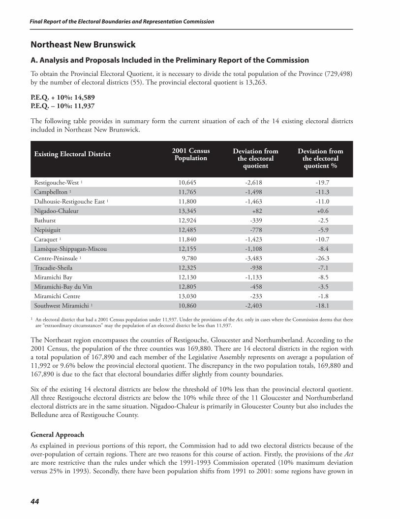
Final Report of the Electoral Boundaries and Representation Commission
44
Northeast New Brunswick
A. Analysis and Proposals Included in the Preliminary Report of the Commission
To obtain the Provincial Electoral Quotient, it is necessary to divide the total population of the Province (729,498) by the number of electoral districts (55). The provincial electoral quotient is 13,263.
P.E.Q. + 10%: 14,589 P.E.Q. – 10%: 11,937
The following table provides in summary form the current situation of each of the 14 existing electoral districts included in Northeast New Brunswick.
Existing Electoral District
2001 Census Population
Deviation from the electoral
quotient
Deviation from the electoral quotient %
Restigouche-West 1 10,645 -2,618 -19.7Campbellton 1 11,765 -1,498 -11.3Dalhousie-Restigouche East 1 11,800 -1,463 -11.0Nigadoo-Chaleur 13,345 +82 +0.6Bathurst 12,924 -339 -2.5Nepisiguit 12,485 -778 -5.9Caraquet 1 11,840 -1,423 -10.7Lamèque-Shippagan-Miscou 12,155 -1,108 -8.4Centre-Péninsule 1 9,780 -3,483 -26.3Tracadie-Sheila 12,325 -938 -7.1Miramichi Bay 12,130 -1,133 -8.5Miramichi-Bay du Vin 12,805 -458 -3.5Miramichi Centre 13,030 -233 -1.8Southwest Miramichi 1 10,860 -2,403 -18.1
1 An electoral district that had a 2001 Census population under 11,937. Under the provisions of the Act, only in cases where the Commission deems that there
are “extraordinary circumstances” may the population of an electoral district be less than 11,937.
The Northeast region encompasses the counties of Restigouche, Gloucester and Northumberland. According to the 2001 Census, the population of the three counties was 169,880. There are 14 electoral districts in the region with a total population of 167,890 and each member of the Legislative Assembly represents on average a population of 11,992 or 9.6% below the provincial electoral quotient. The discrepancy in the two population totals, 169,880 and 167,890 is due to the fact that electoral boundaries differ slightly from county boundaries.
Six of the existing 14 electoral districts are below the threshold of 10% less than the provincial electoral quotient. All three Restigouche electoral districts are below the 10% while three of the 11 Gloucester and Northumberland electoral districts are in the same situation. Nigadoo-Chaleur is primarily in Gloucester County but also includes the Belledune area of Restigouche County.
General Approach
As explained in previous portions of this report, the Commission had to add two electoral districts because of the over-population of certain regions. There are two reasons for this course of action. Firstly, the provisions of the Act are more restrictive than the rules under which the 1991-1993 Commission operated (10% maximum deviation versus 25% in 1993). Secondly, there have been population shifts from 1991 to 2001: some regions have grown in

45
Final Report of the Electoral Boundaries and Representation Commission
population while others have declined. Since the Act makes it mandatory for the Commission to maintain the number of electoral districts constant at 55, it follows that for every electoral district added, one has to be eliminated.
When the Commission reviewed the status of individual electoral districts throughout the Province, it found that eight adjoining electoral districts were all under the 10% threshold allowed by the Act, two in Victoria County, three in Madawaska and three in Restigouche. Under the circumstances, it was impossible to rearrange the boundaries of the eight electoral districts and have them conform to the provisions of the Act. Nor did the Commission feel that the invoking of the “extraordinary circumstances” clause of the Act was warranted in the present circumstances since the issue appeared to be simply one of under-population. The Commission, therefore, proposes to consider the Victoria, Madawaska and Restigouche electoral districts as a unit when arriving at its proposals for the area.
The three electoral districts currently located completely in Restigouche County have a total population of 34,210 (Belledune is included in the Nigadoo-Chaleur electoral district). All three electoral districts are below the 10% threshold. However, the combined population is too high, at an average of 17,105, to be consolidated into two electoral districts.
For this reason, the Commission is proposing to create a new electoral district that would combine the western part of the existing Restigouche West electoral district (from Menneval west) with part of the existing electoral district of Madawaska-la-Vallée to create a new electoral district. The Commission is proposing that the proposed electoral district be called Madawaska-Restigouche. The eastern part of the existing Restigouche West electoral district (Adams Gulch and east), with a population of 4,068, would be added with the population of the two existing electoral districts of Campbellton and Dalhousie-Restigouche East for a total population of 27,633.
The proposal of the Commission would mean that Northeast New Brunswick would share an electoral district with Northwest New Brunswick instead of losing an electoral district.
Electoral District #1 – CampbelltonThe existing Campbellton electoral district had a 2001 Census population of 11,765, or 11.3% below the provincial electoral quotient. The current situation does not meet the requirements of the Act. The Commission is proposing to transfer the following portion of the existing Restigouche West electoral district to the Campbellton electoral district: • Adams Gulch and communities east.
The Commission also proposes to transfer from the Campbellton electoral district to the Dalhousie-Restigouche East electoral district the following: • an area east of the City of Campbellton.
The effect of the transfers would be to increase the population of the proposed electoral district of Campbellton from 11,765 to 13,524 or 2.0% over the provincial electoral quotient.
Electoral District #2 – Dalhousie-Restigouche EastThe existing Dalhousie-Restigouche East electoral district had a 2001 Census population of 11,800, or 11% below the provincial electoral quotient. The current situation does not meet the requirements of the Act. The Commission is proposing to transfer the following portion of the existing Restigouche West electoral district to the Dalhousie-Restigouche East electoral district: • an area south of the electoral district of Campbellton.
The Commission is also proposing to transfer the following portion of the Campbellton electoral district to the Dalhousie-Restigouche East electoral district: • an area east of the electoral district of Campbellton.
The effect of the transfers would be to increase the population of the proposed electoral district of Dalhousie-Restigouche East from 11,800 to 14,109 or 6.4% over the provincial electoral quotient.
Final Report of the Electoral Boundaries and Representation Commission
46
Gloucester and Northumberland Counties – General Approach
The 11 existing electoral districts from Gloucester and Northumberland counties had a 2001 Census population of 133,680 for an average of 12,153 (9.2% below the provincial electoral quotient). The Commission considered two options to address the issues arising from the current situation.
First Option – Decrease the number of electoral districts
The first option that the Commission considered was to decrease the number of electoral districts from 11 to 10 thus providing an average population of 13,368 or 3.8% over the provincial electoral quotient. Since the area in question is primarily rural, the Commission considers that, ideally, the numbers should be at or below the provincial electoral quotient. Nevertheless the option is a viable one. Under this option either the Acadian Peninsula or the Miramichi would lose an electoral district.
Some of the interveners at the public hearings suggested that certain areas could be part of electoral districts located outside the region. Specifically, the suggestion was made that the Boiestown area could become part of the Mactaquac electoral district, and Baie-Sainte-Anne part of the Rogersville-Kouchibouguac electoral district. If the Commission were to accept such proposals, the most likely result would be the elimination of an electoral district in the Gloucester and Northumberland areas.
Second Option – Maintain the current number of electoral districts
The second option that the Commission considered was to try to maintain the existing 11 electoral districts and to redraw the boundaries of each electoral district in such a way that each electoral district could meet the requirements of the Act. The task is far from simple. As already stated, the average population of each electoral district is 12,153. This number is only 216 persons, on average, above the minimum population allowed per electoral district (11,937).
The Commission prefers to maintain the number of electoral districts in the Gloucester and Northumberland Counties. The population of the three electoral districts located in the Chaleur region is within the limits prescribed by the Act. However, certain parts of these electoral districts may be transferred in order to bring other electoral districts up to the minimum population. For this reason, the analysis will begin with Southwest Miramichi and the other Miramichi electoral districts, then the Acadian Peninsula and end with the Chaleur region. The changes proposed by the Commission are as follows:
Electoral District #13 – Southwest MiramichiThe existing Southwest Miramichi electoral district had a 2001 Census population of 10,860, or 18.1% below the provincial electoral quotient. The current situation does not meet the requirements of the Act. The Commission is proposing two additions to the electoral district in order to bring it into conformity with the Act. The Commission is proposing to transfer the following portion of the Mactaquac electoral district to the Southwest Miramichi electoral district: • the McGivney area.
In addition, the Commission proposes to transfer the following area from the Miramichi Centre electoral district to the Southwest Miramichi electoral district: • the parish of Nelson (except the part of Murray Settlement that would be transferred to the Rogersville-
Kouchibouguac electoral district due to the communities of interest factor).
The effect of the transfers would be to increase the population of the proposed electoral district of Southwest Miramichi from 10,860 to 12,017 or 9.4% below the provincial electoral quotient.
Electoral District #12 – Miramichi CentreThe existing Miramichi Centre electoral district had a 2001 Census population of 13,030, or 1.8% below the provincial electoral quotient. The electoral district is in conformity with the provisions of the Act. However, its boundaries need to be changed as part of the Commission’s proposals to bring all of the Gloucester and Northumberland electoral
47
Final Report of the Electoral Boundaries and Representation Commission
districts in line with the provisions of the Act. The Commission, therefore, proposes to transfer the following area from the Miramichi Centre electoral district to the Southwest Miramichi electoral district:
• the Parish of Nelson (except the part of Murray Settlement that would be transferred to the Rogersville-Kouchibouguac electoral district due to the communities of interest factors).
The Commission also proposes to transfer the following area from the Miramichi Centre electoral district to the Miramichi-Neguac electoral district: • a portion of the area formerly known as Douglastown.
In return, the Commission proposes to transfer the following area from Miramichi-Bay du Vin to Miramichi Centre: • a portion of the area formerly known as Chatham Head.
The effect of the transfers would be to decrease the population of the proposed electoral district of Miramichi Centre from 13,030 to 11,944 or 9.9% below the provincial electoral quotient.
Electoral District #11 – Miramichi-Bay du VinThe existing Miramichi-Bay du Vin electoral district had a 2001 Census population of 12,805, or 3.5% below the provincial electoral quotient. The electoral district is in conformity with the provisions of the Act. However, its boundaries need to be changed as part of the Commission’s proposals to bring all of the Gloucester and Northumberland electoral districts in line with the provisions of the Act. The Commission, therefore, proposes to transfer the following area from the Miramichi-Bay du Vin electoral district to the Miramichi Centre electoral district: • that part of the area formerly known as Chatham Head.
The effect of the transfer would be to decrease the population of the proposed electoral district of Miramichi-Bay du Vin from 12,805 to 11,949 or 9.9% below the provincial electoral quotient.
Electoral District #10 – Miramichi-NeguacThe existing Miramichi Bay electoral district had a 2001 Census population of 12,130, or 8.5% below the provincial electoral quotient. The electoral district is in conformity with the provisions of the Act. However, its boundaries need to be changed as part of the Commission’s proposals to bring all of the Gloucester and Northumberland electoral districts in line with the provisions of the Act.
The Commission, therefore, proposes to transfer the following area from the Miramichi Centre electoral district to the Miramichi Bay electoral district: • that part of the area formerly known as Douglastown.
The Commission also proposes to transfer the following area from the existing Miramichi Bay electoral district to the Tracadie-Sheila electoral district: • Haut-Rivière-du-Portage and Rivière-du-Portage.
The effect of the transfers would be to decrease the population of the proposed electoral district of Miramichi-Neguac from 12,130 to 11,966 or 9.8% below the provincial electoral quotient. The Commission is also proposing to change the name of the electoral district from Miramichi Bay to Miramichi-Neguac.
Electoral District #9 – Tracadie-SheilaThe existing Tracadie-Sheila electoral district had a 2001 Census population of 12,325, or 7.1% below the provincial electoral quotient. The electoral district is in conformity with the provisions of the Act. However, its boundaries need to be changed as part of the Commission’s proposals to bring all of the Gloucester and Northumberland electoral districts in line with the provisions of the Act.
Final Report of the Electoral Boundaries and Representation Commission
48
The Commission proposes to transfer the following area from the existing Miramichi Bay electoral district to the Tracadie-Sheila electoral district: • Haut-Rivière-du-Portage and Rivière-du-Portage.
The Commission proposes to transfer the following area from the Tracadie-Sheila electoral district to the Centre-Péninsule electoral district: • Pont Landry.
The effect of the transfers would be to decrease the population of the proposed electoral district of Tracadie-Sheila from 12,325 to 12,068 or 9.0% below the provincial electoral quotient.
Electoral District #8 – Centre-PéninsuleThe existing Centre-Péninsule electoral district had a 2001 Census population of 9,780 or 26.3% below the provincial electoral quotient. The current situation does not meet the requirements of the Act. The Commission is proposing to transfer the following portion of the Tracadie-Sheila electoral district to the Centre-Péninsule electoral district: • Pont Landry.
The Commission also proposes to transfer the following area from the Lamèque-Shippagan-Miscou electoral district to the Centre-Péninsule electoral district: • Baie de Petit Pokemouche.
In addition, the Commission proposes to transfer the following area from the Nepisiguit electoral district to the Centre-Péninsule electoral district: • Saint-Sauveur.
Meanwhile, the Commission proposes to transfer the portion of a community located in the Centre-Péninsule electoral district to the Caraquet electoral district: • part of the community of Burnsville.
The effect of the transfers would be to increase the population of the proposed electoral district of Centre-Péninsule from 9,780 to 12,099 or 8.8% below the provincial electoral quotient.
Electoral District #7 – Lamèque-Shippagan-MiscouThe existing Lamèque-Shippagan-Miscou electoral district had a 2001 Census population of 12,155 or 8.4% below the provincial electoral quotient. The electoral district is in conformity with the provisions of the Act. However, its boundaries need to be changed as part of the Commission’s proposals to bring all of the Gloucester and Northumberland electoral districts in line with the provisions of the Act.
The Commission is, therefore, proposing to transfer the following area to the Centre-Péninsule electoral district: • Baie de Petit Pokemouche.
The effect of the transfer would be to decrease the population of the proposed electoral district of Lamèque-Shippagan-Miscou from 12,155 to 11,961 or 9.8% below the provincial electoral quotient.
Electoral District #6 – CaraquetThe existing Caraquet electoral district had a 2001 Census population of 11,840 or 10.7% below the provincial electoral quotient. The current situation does not meet the requirements of the Act. The Commission is proposing to transfer the following portion of the Nepisiguit electoral district to the Caraquet electoral district: • part of the community of Burnsville.
In addition, the Commission proposes to transfer the following area from the Centre-Péninsule electoral district to the Caraquet electoral district: • part of the community of Burnsville.
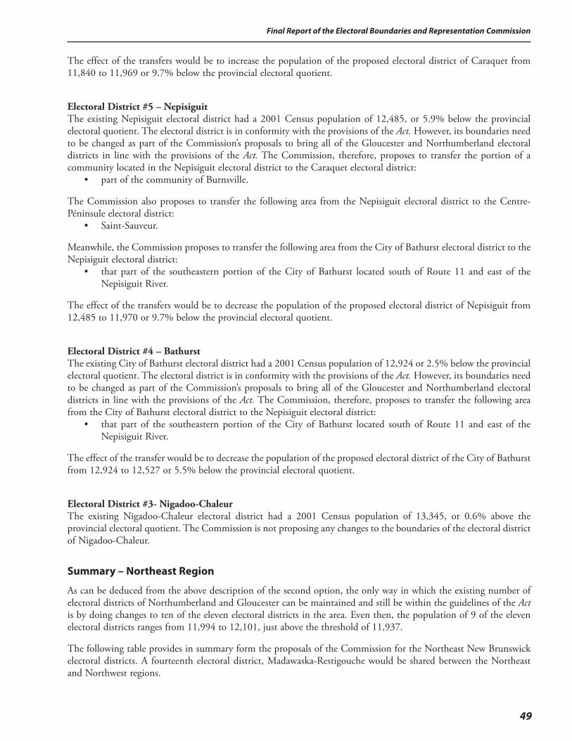
49
Final Report of the Electoral Boundaries and Representation Commission
The effect of the transfers would be to increase the population of the proposed electoral district of Caraquet from 11,840 to 11,969 or 9.7% below the provincial electoral quotient.
Electoral District #5 – NepisiguitThe existing Nepisiguit electoral district had a 2001 Census population of 12,485, or 5.9% below the provincial electoral quotient. The electoral district is in conformity with the provisions of the Act. However, its boundaries need to be changed as part of the Commission’s proposals to bring all of the Gloucester and Northumberland electoral districts in line with the provisions of the Act. The Commission, therefore, proposes to transfer the portion of a community located in the Nepisiguit electoral district to the Caraquet electoral district: • part of the community of Burnsville.
The Commission also proposes to transfer the following area from the Nepisiguit electoral district to the Centre-Péninsule electoral district: • Saint-Sauveur.
Meanwhile, the Commission proposes to transfer the following area from the City of Bathurst electoral district to the Nepisiguit electoral district: • that part of the southeastern portion of the City of Bathurst located south of Route 11 and east of the
Nepisiguit River.
The effect of the transfers would be to decrease the population of the proposed electoral district of Nepisiguit from 12,485 to 11,970 or 9.7% below the provincial electoral quotient.
Electoral District #4 – BathurstThe existing City of Bathurst electoral district had a 2001 Census population of 12,924 or 2.5% below the provincial electoral quotient. The electoral district is in conformity with the provisions of the Act. However, its boundaries need to be changed as part of the Commission’s proposals to bring all of the Gloucester and Northumberland electoral districts in line with the provisions of the Act. The Commission, therefore, proposes to transfer the following area from the City of Bathurst electoral district to the Nepisiguit electoral district: • that part of the southeastern portion of the City of Bathurst located south of Route 11 and east of the
Nepisiguit River.
The effect of the transfer would be to decrease the population of the proposed electoral district of the City of Bathurst from 12,924 to 12,527 or 5.5% below the provincial electoral quotient.
Electoral District #3- Nigadoo-ChaleurThe existing Nigadoo-Chaleur electoral district had a 2001 Census population of 13,345, or 0.6% above the provincial electoral quotient. The Commission is not proposing any changes to the boundaries of the electoral district of Nigadoo-Chaleur.
Summary – Northeast Region
As can be deduced from the above description of the second option, the only way in which the existing number of electoral districts of Northumberland and Gloucester can be maintained and still be within the guidelines of the Act is by doing changes to ten of the eleven electoral districts in the area. Even then, the population of 9 of the eleven electoral districts ranges from 11,994 to 12,101, just above the threshold of 11,937.
The following table provides in summary form the proposals of the Commission for the Northeast New Brunswick electoral districts. A fourteenth electoral district, Madawaska-Restigouche would be shared between the Northeast and Northwest regions.
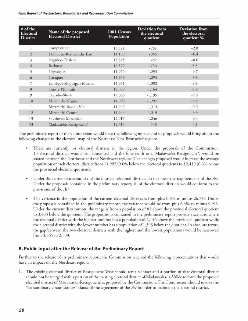
Final Report of the Electoral Boundaries and Representation Commission
50
# of the Electoral District
Name of the proposed Electoral District
2001 Census Population
Deviation from the electoral
quotient
Deviation from the electoral quotient %
1 Campbellton 13,524 +261 +2.02 Dalhousie-Restigouche East 14,109 +846 +6.43 Nigadoo-Chaleur 13,345 +82 +0.64 Bathurst 12,527 -736 -5.55 Nepisiguit 11,970 -1,293 -9.76 Caraquet 11,969 -1,294 -9.87 Lamèque-Shippagan-Miscou 11,961 -1,302 -9.88 Centre-Péninsule 12,099 -1,164 -8.89 Tracadie-Sheila 12,068 -1,195 -9.010 Miramichi-Neguac 11,966 -1,297 -9.811 Miramichi-Bay du Vin 11,949 -1,314 -9.912 Miramichi Centre 11,944 -1,319 -9.913 Southwest Miramichi 12,017 -1,246 -9.453 Madawaska-Restigouche* 12,715 -548 -4.1
The preliminary report of the Commission would have the following impact and its proposals would bring about the following changes to the electoral map of the Northeast New Brunswick region:
• There are currently 14 electoral districts in the region. Under the proposals of the Commission, 13 electoral districts would be maintained and the fourteenth one, Madawaska-Restigouche*, would be shared between the Northeast and the Northwest regions. The changes proposed would increase the average population of each electoral district from 11,992 (9.6% below the electoral quotient) to 12,419 (6.6% below the provincial electoral quotient).
• Under the current situation, six of the fourteen electoral districts do not meet the requirements of the Act. Under the proposals contained in the preliminary report, all of the electoral districts would conform to the provisions of the Act.
• The variance in the population of the current electoral districts is from plus 0.6% to minus 26.3%. Under the proposals contained in the preliminary report, the variance would be from plus 6.4% to minus 9.9%. Under the current distribution, the range is from a population of 82 above the provincial electoral quotient to 3,483 below the quotient. The propositions contained in the preliminary report provide a scenario where the electoral district with the highest number has a population of 1,146 above the provincial quotient while the electoral district with the lowest number has a population of 1,393 below the quotient. In absolute terms, the gap between the two electoral districts with the highest and the lowest populations would be narrowed from 3,565 to 2,539.
B. Public Input after the Release of the Preliminary Report
Further to the release of its preliminary report, the Commission received the following representations that would have an impact on the Northeast region:
1. The existing electoral district of Restigouche West should remain intact and a portion of that electoral district should not be merged with a portion of the existing electoral district of Madawaska-la-Vallée to form the proposed electoral district of Madawaska-Restigouche as proposed by the Commission. The Commission should invoke the “extraordinary circumstances” clause of the agreement of the Act in order to maintain the electoral district.
51
Final Report of the Electoral Boundaries and Representation Commission
2. Restigouche should not lose an electoral district.
3. The village of Belledune should have been transferred from the existing electoral district of Nigadoo-Chaleur to the proposed electoral district of Dalhousie-Restigouche East, in which case it would have been possible, through further internal redistributions within the county of Restigouche, to maintain three electoral districts totally within the boundaries of the county.
4. The western part of the current electoral district of Miramichi Bay should be removed from the electoral district and transferred to the electoral district of Miramichi Centre.
5. The communities of Rivière-du-Portage and Haut-Rivière-du-Portage should not be divided with part being transferred to the proposed Tracadie-Sheila electoral district. Both communities should remain totally in the proposed electoral district of Miramichi-Neguac.
6. The name of the proposed electoral district of Campbellton should be changed to Campbellton-Restigouche Centre in order to reflect the extended boundaries.
7. The Commission proposed in its preliminary report that the name of the electoral district of Miramichi Bay should be changed to Miramichi-Neguac to avoid possible confusion with the name of the electoral district of Miramichi-Bay du Vin. One intervener agreed with this proposal. Some wanted to retain the name of Miramichi Bay while another intervener proposed the name Miramichi-Alnwick as an alternative.
8. The Local Service Districts (LSDs) of Allardville and Saint-Sauveur should be in the same electoral district.
9. The eastern boundary of the proposed Campbellton electoral district should include part of McLeods as far as Maple Green.
C. Response to the Public Input and Recommendations of the Commission for the Northeast New Brunswick Region
In arriving at its decisions concerning the electoral districts of Northeast New Brunswick, the Commission reviewed carefully the representations it received at the public hearings and by correspondence sent to the office of the Commission. The representations were also reviewed in the context of the preceding regional analysis of this report.
Public Input:1. The existing electoral district of Restigouche West should remain intact and a portion of that electoral district should
not be merged with a portion of the existing electoral district of Madawaska-la-Vallée to form the new electoral district of Madawaska-Restigouche as proposed by the Commission. The Commission should invoke the “extraordinary circumstances” clause of the agreement of the Act in order to maintain the electoral district.
Response of the Commission:The only way in which the Commission can accede to this request is to invoke the “extraordinary circumstances” clause of the Act. The Commission does not consider that having a population below the threshold of 11,937 as established by the Act is, by itself, sufficient to invoke the “extraordinary circumstances” clause of the Act.
Public Input:2. Restigouche should not lose an electoral district.
Public Input:3. The village of Belledune should have been transferred from the existing electoral district of Nigadoo-Chaleur to the proposed
electoral district of Dalhousie-Restigouche East, in which case it would have been possible, through further internal redistributions within the county of Restigouche, to maintain three electoral districts totally within the boundaries of the county.
Final Report of the Electoral Boundaries and Representation Commission
52
Response of the Commission: (2 & 3)The Commission looked at the Province, both globally and regionally, in order to determine how many and where electoral districts would have to be added according to the provisions of the Act. On the basis of this analysis, the Commission determined that it had to add two electoral districts, one in each of the Southeast and Central regions. Since the Act also stipulates that the number of electoral districts has to remain constant at 55, it was therefore mandatory for the Commission to eliminate two electoral districts elsewhere in the Province.
The initial analysis of the Commission identified two problematic areas. Firstly, there were eight contiguous electoral districts in northern New Brunswick with a population each below the threshold of 11,937. Five of these electoral districts were located in the Northwest region, namely in the counties of Victoria and Madawaska, and three were in the Northeast region, namely in Restigouche County. Secondly, three contiguous electoral districts located in the Southwest region, two in Charlotte and Grand Bay-Westfield, were also below the threshold of 11,937.
Northern New Brunswick, including both the Northwest and Northeast regions, has 21 electoral districts. Of these, 11 have a population below the acceptable level of 11,937. Including Belledune within the boundaries of Restigouche would have required major changes to neighbouring electoral districts, including the transfer of part of the Campbellton-Atholville-Tide Head area to the electoral district of Restigouche West. Nor would that approach have resolved the problem of adjoining electoral districts. In the case of Restigouche County, it became impossible to retain three electoral districts because of the complexities of the situation in the overall northern part of the Province that includes both the Northwest and the Northeast economic regions of the Province.
First, the shift of the village of Belledune into the Dalhousie-Restigouche East electoral district would leave the electoral district of Nigadoo-Chaleur below the minimum population allowed under the Act. As most of the other electoral districts in the Chaleur, Acadian Peninsula and Miramichi regions (as defined by the boundaries of the Community Economic Development Agencies – CEDAs) are all either below or only slightly above the minimum, any attempt to transfer population from those districts westward in order to compensate for the loss of the Belledune area would ultimately leave some other electoral district below the required minimum. The transfer of the village of Belledune into the electoral district of Dalhousie-Restigouche East would thus necessitate the loss of an electoral district from somewhere in the Northeast region.
In addition, it is the Commission’s opinion that there is no viable way to maintain three electoral districts within the boundaries of Restigouche county and still respect the requirements of the Act in relation to the electoral districts located in the counties of Victoria and Madawaska. Madawaska-Victoria currently has five electoral districts – four mainly Francophone and one mainly Anglophone, all of which are below the minimum population required by the Act. The under-population of the mainly Anglophone electoral district of Victoria-Tobique can be resolved by the transfer of population from Carleton County. However, and as explained earlier in this report, it is not possible to maintain the four mainly Francophone electoral districts as they are to resolve the problem through the redistribution of population within the area itself. Yet to reduce the number of electoral districts in this area from four to three is also not possible since the total population divided by three equals 15,009, a figure which exceeds the maximum permitted under the Act. Consequently, in order to bring the four Madawaska-Victoria electoral districts into conformity with the Act, the Commission has no option but to combine a portion of the Madawaska population with the population from some adjoining area. Since the mainly francophone population of this area is bounded by Quebec on the north, the United States on the west and English-speaking parts of Victoria county on the south, the only adjacent area where this population from the northwest region can be combined with is from the electoral district of Restigouche West. The creation of an electoral district combining residents of Madawaska County and residents of Restigouche county is thus an inescapable necessity.
53
Final Report of the Electoral Boundaries and Representation Commission
In summary, the complexity of the situation in Madawaska leaves the Commission no choice but to create a new electoral district that combines some or all of the population of Restigouche-West with one of the electoral districts in Madawaska. Whether the village of Belledune is added to the Dalhousie Restigouche-East electoral district or left in the Nigadoo-Chaleur electoral district, the objective of having three electoral districts entirely within the boundaries of Restigouche County is simply not a viable alternative. And because leaving the village of Belledune in the electoral district of Nigadoo-Chaleur is the only way to obviate the need for a reduction in the number of seats in the Northeast region, the Commission concludes that Belledune should remain in the electoral district of Nigadoo-Chaleur.
The population of the proposed electoral district of Restigouche-La-Vallée is almost evenly divided between the existing electoral districts of Restigouche West and Madawaska-la-Vallée. The breakdown of population of the proposed electoral district is 6,577 from the Restigouche West electoral district and 6,345 from the electoral district of Madawaska-la-Vallée. Since the majority of the population of the proposed electoral district will be composed of residents from Restigouche County, it is not accurate to state simply that the existing district of Restigouche West has been “eliminated”. It is rather a case where the Northeast and the Northwest regions have each lost, in a manner of speaking, half of an electoral district instead of one of the regions losing a complete electoral district.
Public Input:4. The western part of the current electoral district of Miramichi Bay should be removed from the electoral district and
transferred the electoral district of Miramichi Centre.
Response of the Commission:
If the Commission accepted this proposal, the electoral district of Miramichi Bay would no longer meet the provisions of the Act since its population would be below the threshold of 11,937. In such circumstances, the most likely scenario would be that the population of the eastern portion of the current electoral district would be absorbed within the four electoral districts being proposed for the Acadian Peninsula. The end result would be the loss of an electoral district in the Miramichi region. The Commission is convinced that the overall interests of the region are better served by maintaining the four existing electoral districts in the Miramichi region.
Public Input:
5. The communities of Rivière-du-Portage and Haut-Rivière-du-Portage should not be divided with part being transferred to the proposed Tracadie-Sheila electoral district. Both communities should remain totally in the proposed electoral district of Miramichi-Neguac.
Response of the Commission:
The Commission tried to avoid the division of communities to the extent possible. The Commission will only divide communities in cases where it has not been able to identify another alternative. The suggestion was made that the Commission could have maintained the status quo in the existing electoral district of Miramichi Bay and instead eliminated an electoral district in the Acadian Peninsula. According to the 2001 Census, the total population of the four electoral districts located in the Acadian Peninsula was 46,100. The Commission is not in a position to allocate a population of 46,100 into three electoral districts since the maximum population that an electoral district may have, even at 10% above the electoral quotient, is 14,589. The most likely scenario would be that the excess population in the Acadian Peninsula would be combined with the population living in the eastern part of the existing Miramichi Bay electoral district. A proposal was also made to the Commission that the western portion of the existing electoral district of Miramichi Bay should be transferred to the neighbouring electoral district of Miramichi Centre. As explained previously, the end result would be the loss of an electoral district in the Miramichi Region. However, the Commission believes that the overall interests of the region are better served by maintaining the current number of electoral districts in the Miramichi Region.
Final Report of the Electoral Boundaries and Representation Commission
54
Public Input:
6. The name of the proposed electoral district of Campbellton should be changed to Campbellton-Restigouche Centre in order to reflect the extended boundaries.
Response of the Commission:The Commission agrees and will recommend that the name of the electoral district should be Campbellton-Restigouche Centre.
Public Input:
7. The Commission proposed in its preliminary report that the name of the electoral district of Miramichi Bay should be changed to Miramichi-Neguac to avoid possible confusion with the name of the electoral district of Miramichi-Bay du Vin. One intervener agreed with this proposal. Some wanted to retain the name of Miramichi Bay while another intervener proposed the name Miramichi-Alnwick as an alternative.
Response of the Commission:Since there does not seem to be a consensus in the region, the Commission recommends that the name of Miramichi Bay be retained.
Public Input:
8. The Local Service Districts (LSDs) of Allardville and Saint-Sauveur should be in the same electoral district.
Response of the Commission:The Commission cannot accommodate this request since the result would be that either the electoral district of Nepisiguit or the electoral district of Centre Péninsule would have a population under 11,937 and therefore, no longer meet the provisions of the Act.
Public Input:
9. The eastern boundary of the proposed Campbellton electoral district should include part of McLeods as far as Maple Green.
Response of the Commission:The Commission has determined that the eastern boundary of the Campbellton electoral district should be the city limits of Campbellton as proposed in the preliminary report.
Note: The names of the electoral districts form part of the final report of the Commission. However, the names may be amended by the Lieutenant-Governor-in-Council on the recommendation of the Legislative Administrative Committee.
55
Final Report of the Electoral Boundaries and Representation Commission
General Comments and Acknowledgements
The Commission wishes to thank all those who contributed to the work of the Commission. First and foremost, the Commission expresses its appreciation to the groups and individuals who took the time to prepare briefs and accepted the invitation to attend public hearings in order to share their thoughts with the Commissioners. Others provided their comments directly to the office of the Commission. The Commissioners considered all the proposals received and the public input was very helpful in the drafting of the preliminary and final reports of the Commission. The Commissioners were impressed by the caliber of the submissions received. While it was not possible to respond favourably to every proposal received, the Commission made every effort to accommodate in its reports the numerous representations received. Nevertheless, the Commission was bound to operate within the provisions of the Act.
Some interveners questioned some of the provisions of the Act. Some would have more than 55 electoral districts while others would have fewer. Some questioned the use of the population data from the 2001 Census and suggested that the Commission should delay its final report until the results of the 2006 Census became available. Some suggested that the 10% deviation allowed from the electoral quotient was too restrictive and opined that the deviation allowed should be higher, even as high as 25%. . There were also other representations made that were not relevant to the mandate of the Commission. While the Commission listened to these representations, they are not dealt with in this report because they are clearly outside the scope of the mandate of the Commission. The Commission operated, as it had to, on the basis of the Electoral Boundaries and Representation Act adopted unanimously by the Legislative Assembly in June 2005.
The Commission expresses its gratitude to the public servants of the Province of New Brunswick who contributed in different ways to the work of the Commission. Included are interpreters, translators and employees of the Print Shop of the Department of Supply and Services as well as staff persons from the Executive Council Office, Communications New Brunswick and the Department of Finance. Special thanks are due to the senior staff and support personnel at the Office of the Chief Electoral Officer. The Commission was also assisted during both sets of public hearings by Ron Armitage from the Office of the Chief Electoral Officer and Valerie Kilfoil from Communications New Brunswick. Finally, the Commissioners express their sincere appreciation to the staff of the Commission: Frederic J. Arsenault, Executive Director, Lisa Lacenaire-McHardie, Senior Policy Analyst and Joanne Morin, Administrative Assistant. The fact that the Commission was able to meet the deadlines set out in the Legislation is testimony to the full cooperation of all those who were involved in the process.
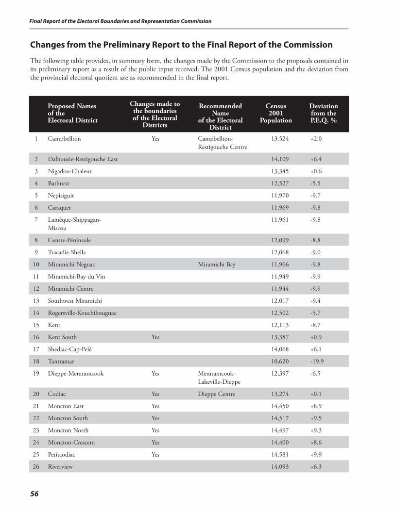
Final Report of the Electoral Boundaries and Representation Commission
56
Changes from the Preliminary Report to the Final Report of the Commission
The following table provides, in summary form, the changes made by the Commission to the proposals contained in its preliminary report as a result of the public input received. The 2001 Census population and the deviation from the provincial electoral quotient are as recommended in the final report.
Proposed Names of the Electoral District
Changes made to the boundaries of the Electoral
Districts
Recommended
Name of the Electoral
District
Census 2001
Population
Deviation from the P.E.Q. %
1 Campbellton Yes Campbellton-Restigouche Centre
13,524 +2.0
2 Dalhousie-Restigouche East 14,109 +6.4
3 Nigadoo-Chaleur 13,345 +0.6
4 Bathurst 12,527 -5.5
5 Nepisiguit 11,970 -9.7
6 Caraquet 11,969 -9.8
7 Lamèque-Shippagan-Miscou
11,961 -9.8
8 Centre-Péninsule 12,099 -8.8
9 Tracadie-Sheila 12,068 -9.0
10 Miramichi Neguac Miramichi Bay 11,966 -9.8
11 Miramichi-Bay du Vin 11,949 -9.9
12 Miramichi Centre 11,944 -9.9
13 Southwest Miramichi 12,017 -9.4
14 Rogersville-Kouchibouguac 12,502 -5.7
15 Kent 12,113 -8.7
16 Kent South Yes 13,387 +0.9
17 Shediac-Cap-Pelé 14,068 +6.1
18 Tantramar 10,620 -19.9
19 Dieppe-Memramcook Yes Memramcook-Lakeville-Dieppe
12,397 -6.5
20 Codiac Yes Dieppe Centre 13,274 +0.1
21 Moncton East Yes 14,450 +8.9
22 Moncton South Yes 14,517 +9.5
23 Moncton North Yes 14,497 +9.3
24 Moncton-Crescent Yes 14,400 +8.6
25 Petitcodiac Yes 14,581 +9.9
26 Riverview 14,093 +6.3
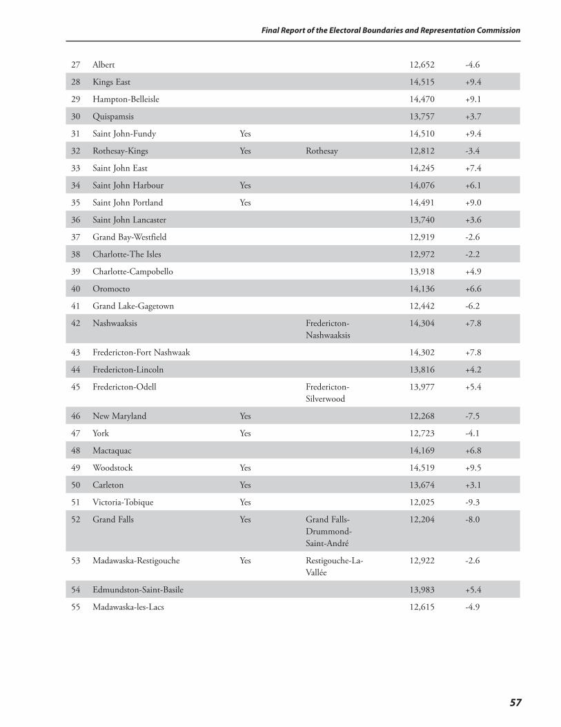
57
Final Report of the Electoral Boundaries and Representation Commission
27 Albert 12,652 -4.6
28 Kings East 14,515 +9.4
29 Hampton-Belleisle 14,470 +9.1
30 Quispamsis 13,757 +3.7
31 Saint John-Fundy Yes 14,510 +9.4
32 Rothesay-Kings Yes Rothesay 12,812 -3.4
33 Saint John East 14,245 +7.4
34 Saint John Harbour Yes 14,076 +6.1
35 Saint John Portland Yes 14,491 +9.0
36 Saint John Lancaster 13,740 +3.6
37 Grand Bay-Westfield 12,919 -2.6
38 Charlotte-The Isles 12,972 -2.2
39 Charlotte-Campobello 13,918 +4.9
40 Oromocto 14,136 +6.6
41 Grand Lake-Gagetown 12,442 -6.2
42 Nashwaaksis Fredericton-Nashwaaksis
14,304 +7.8
43 Fredericton-Fort Nashwaak 14,302 +7.8
44 Fredericton-Lincoln 13,816 +4.2
45 Fredericton-Odell Fredericton-Silverwood
13,977 +5.4
46 New Maryland Yes 12,268 -7.5
47 York Yes 12,723 -4.1
48 Mactaquac 14,169 +6.8
49 Woodstock Yes 14,519 +9.5
50 Carleton Yes 13,674 +3.1
51 Victoria-Tobique Yes 12,025 -9.3
52 Grand Falls Yes Grand Falls-Drummond- Saint-André
12,204 -8.0
53 Madawaska-Restigouche Yes Restigouche-La-Vallée
12,922 -2.6
54 Edmundston-Saint-Basile 13,983 +5.4
55 Madawaska-les-Lacs 12,615 -4.9
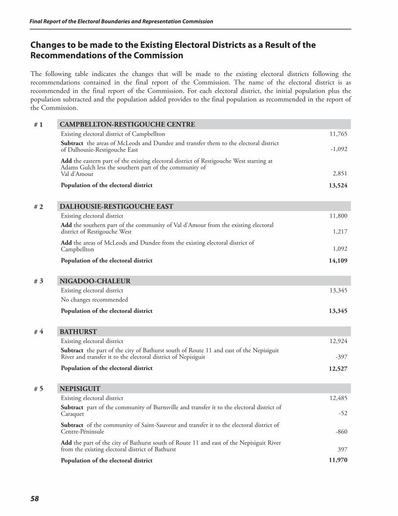
Final Report of the Electoral Boundaries and Representation Commission
58
Changes to be made to the Existing Electoral Districts as a Result of the Recommendations of the Commission
The following table indicates the changes that will be made to the existing electoral districts following the recommendations contained in the final report of the Commission. The name of the electoral district is as recommended in the final report of the Commission. For each electoral district, the initial population plus the population subtracted and the population added provides to the final population as recommended in the report of the Commission.
# 1 CAMPBELLTON-RESTIGOUCHE CENTRE Existing electoral district of CampbelltonSubtract the areas of McLeods and Dundee and transfer them to the electoral district of Dalhousie-Restigouche East
Add the eastern part of the existing electoral district of Restigouche West starting at Adams Gulch less the southern part of the community of Val d’Amour
Population of the electoral district
11,765
-1,092
2,851
13,524
# 2 DALHOUSIE-RESTIGOUCHE EASTExisting electoral districtAdd the southern part of the community of Val d’Amour from the existing electoral district of Restigouche West
Add the areas of McLeods and Dundee from the existing electoral district of Campbellton
Population of the electoral district
11,800
1,217
1,092
14,109
# 3 NIGADOO-CHALEUR Existing electoral districtNo changes recommended
Population of the electoral district
13,345
13,345
# 4 BATHURST Existing electoral districtSubtract the part of the city of Bathurst south of Route 11 and east of the Nepisiguit River and transfer it to the electoral district of Nepisiguit
Population of the electoral district
12,924
-397
12,527
# 5 NEPISIGUITExisting electoral districtSubtract part of the community of Burnsville and transfer it to the electoral district of Caraquet
Subtract of the community of Saint-Sauveur and transfer it to the electoral district of Centre-Péninsule
Add the part of the city of Bathurst south of Route 11 and east of the Nepisiguit River from the existing electoral district of Bathurst
Population of the electoral district
12,485
-52
-860
397
11,970

59
Final Report of the Electoral Boundaries and Representation Commission
# 6 CARAQUET Existing electoral districtAdd part of the community of Burnsville from the existing electoral district of Nepisiguit
Add part of the community of Burnsville from the existing electoral district of Centre-Péninsule
Population of the electoral district
11,840
52
77
11,969
# 7 LAMÈQUE-SHIPPAGAN-MISCOU Existing electoral districtSubtract the community of Baie de Petit-Pokemouche and transfer it to the electoral district of Centre-Péninsule
Population of the electoral district
12,155
-194
11,961
# 8 CENTRE-PÉNINSULE Existing electoral districtSubtract part of the community of Burnsville and transfer it to the electoral district of Caraquet
Add the community of Saint-Sauveur from the existing electoral district of Nepisiguit
Add the community of Baie de Petit-Pokemouche from the existing electoral district of Lamèque-Shippagan-Miscou
Add the areas of Pont-Landry and Losier Settlement from the existing electoral district of Tracadie-Sheila
Population of the electoral district
9,780
-77
860
194
1,342
12,099
# 9 TRACADIE-SHEILA Existing electoral districtSubtract the areas of Pont-Landry and Losier Settlement and transfer them to the electoral district of Centre-Péninsule
Add part of Haut-Rivière-du-Portage and part of Rivière-du-Portage from the existing electoral district of Miramichi Bay
Population of the electoral district
12 325
-1 342
1 085
12 068
# 10 MIRAMICHI BAYExisting electoral district 12,130 Subtract part of Haut-Rivière-du-Portage and part of Rivière-du-Portage and transfer them to the electoral district of Tracadie-Sheila -1,085
Add part of the city of Miramichi known as a part of Douglastown from the existing electoral district of Miramichi Centre 921
Population of the electoral district 11,966
# 11 MIRAMICHI-BAY DU VIN Existing electoral districtSubtract part of the city of Miramichi known as a part of Chatham Head and the area of Douglasfield and transfer them to the electoral district of Miramichi Centre
Population of the electoral district
12,805
-856
11,949
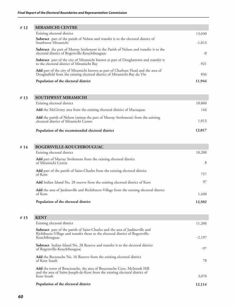
Final Report of the Electoral Boundaries and Representation Commission
60
# 12 MIRAMICHI CENTRE Existing electoral districtSubtract part of the parish of Nelson and transfer it to the electoral district of Southwest Miramichi
Subtract the part of Murray Settlement in the Parish of Nelson and transfer it to the electoral district of Rogersville-Kouchibouguac
Subtract part of the city of Miramichi known as part of Douglastown and transfer it to the electoral district of Miramichi Bay
Add part of the city of Miramichi known as part of Chatham Head and the area of Douglasfield from the existing electoral district of Miramichi-Bay du Vin
Population of the electoral district
13,030
-1,013
-8
-921
856
11,944
# 13 SOUTHWEST MIRAMICHI Existing electoral district
Add the McGivney area from the existing electoral district of Mactaquac
Add the parish of Nelson (minus the part of Murray Settlement) from the existing electoral district of Miramichi Centre
Population of the recommended electoral district
10,860
144
1,013
12,017
# 14 ROGERSVILLE-KOUCHIBOUGUAC Existing electoral district
Add part of Murray Settlement from the existing electoral district of Miramichi Centre
Add part of the parish of Saint-Charles from the existing electoral district of Kent
Add Indian Island No. 28 reserve from the existing electoral district of Kent
Add the area of Jardineville and Richibucto-Village from the existing electoral district of Kent
Population of the electoral district
10,200
8
757
97
1,440
12,502
# 15 KENT Existing electoral district
Subtract part of the parish of Saint-Charles and the area of Jardineville and Richibucto-Village and transfer them to the electoral district of Rogersville-Kouchibouguac
Subtract Indian Island No. 28 Reserve and transfer it to the electoral district of Rogersville-Kouchibouguac
Add the Buctouche No. 16 Reserve from the existing electoral district of Kent South
Add the town of Bouctouche, the area of Bouctouche Cove, McIntosh Hill and the area of Saint-Joseph-de-Kent from the existing electoral district of Kent South
Population of the electoral district
11,260
-2,197
-97
78
3,070
12,114
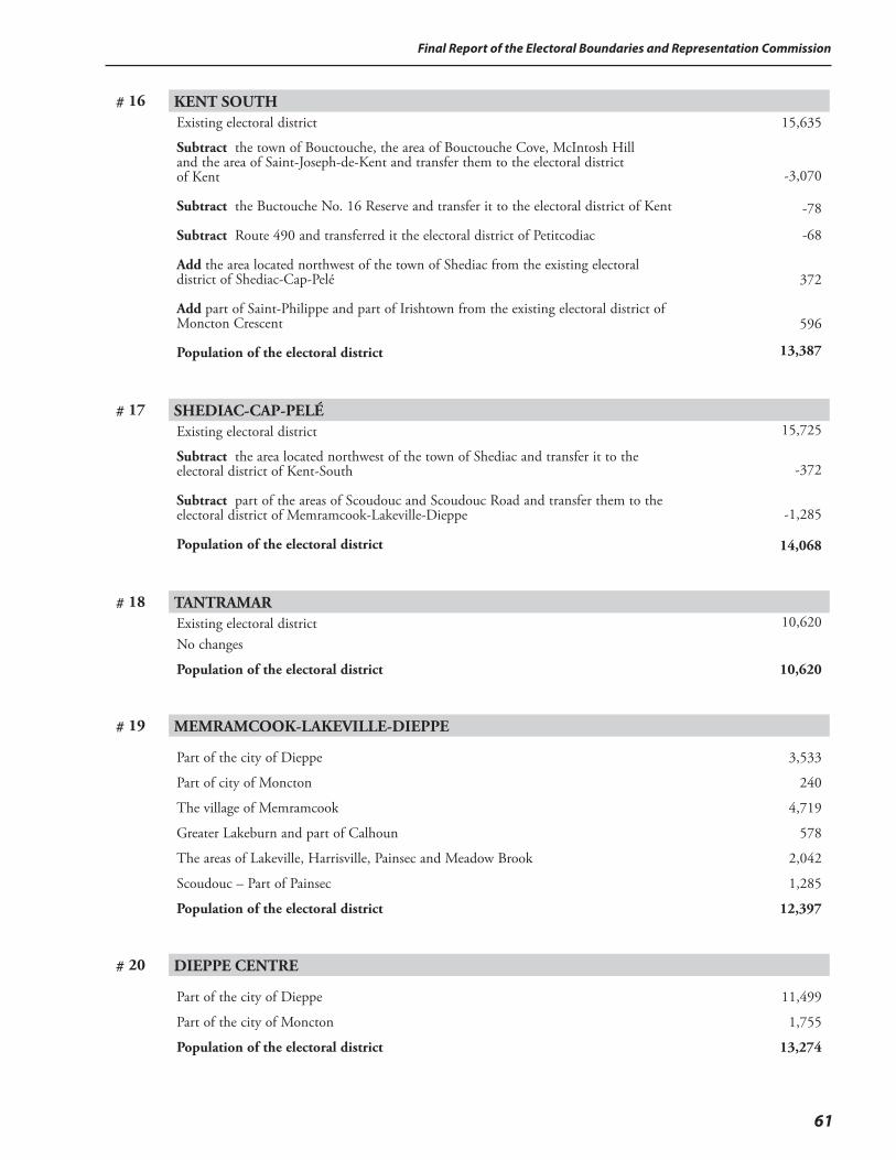
61
Final Report of the Electoral Boundaries and Representation Commission
# 16 KENT SOUTH Existing electoral district
Subtract the town of Bouctouche, the area of Bouctouche Cove, McIntosh Hill and the area of Saint-Joseph-de-Kent and transfer them to the electoral district of Kent
Subtract the Buctouche No. 16 Reserve and transfer it to the electoral district of Kent
Subtract Route 490 and transferred it the electoral district of Petitcodiac
Add the area located northwest of the town of Shediac from the existing electoral district of Shediac-Cap-Pelé
Add part of Saint-Philippe and part of Irishtown from the existing electoral district of Moncton Crescent
Population of the electoral district
15,635
-3,070
-78
-68
372
596
13,387
# 17 SHEDIAC-CAP-PELÉ Existing electoral district
Subtract the area located northwest of the town of Shediac and transfer it to the electoral district of Kent-South
Subtract part of the areas of Scoudouc and Scoudouc Road and transfer them to the electoral district of Memramcook-Lakeville-Dieppe
Population of the electoral district
15,725
-372
-1,285
14,068
# 18 TANTRAMAR Existing electoral districtNo changes
Population of the electoral district
10,620
10,620
# 19 MEMRAMCOOK-LAKEVILLE-DIEPPE
Part of the city of Dieppe
Part of city of Moncton
The village of Memramcook
Greater Lakeburn and part of Calhoun
The areas of Lakeville, Harrisville, Painsec and Meadow Brook
Scoudouc – Part of Painsec
Population of the electoral district
3,533
240
4,719
578
2,042
1,285
12,397
# 20 DIEPPE CENTRE
Part of the city of Dieppe
Part of the city of Moncton
Population of the electoral district
11,499
1,755
13,274
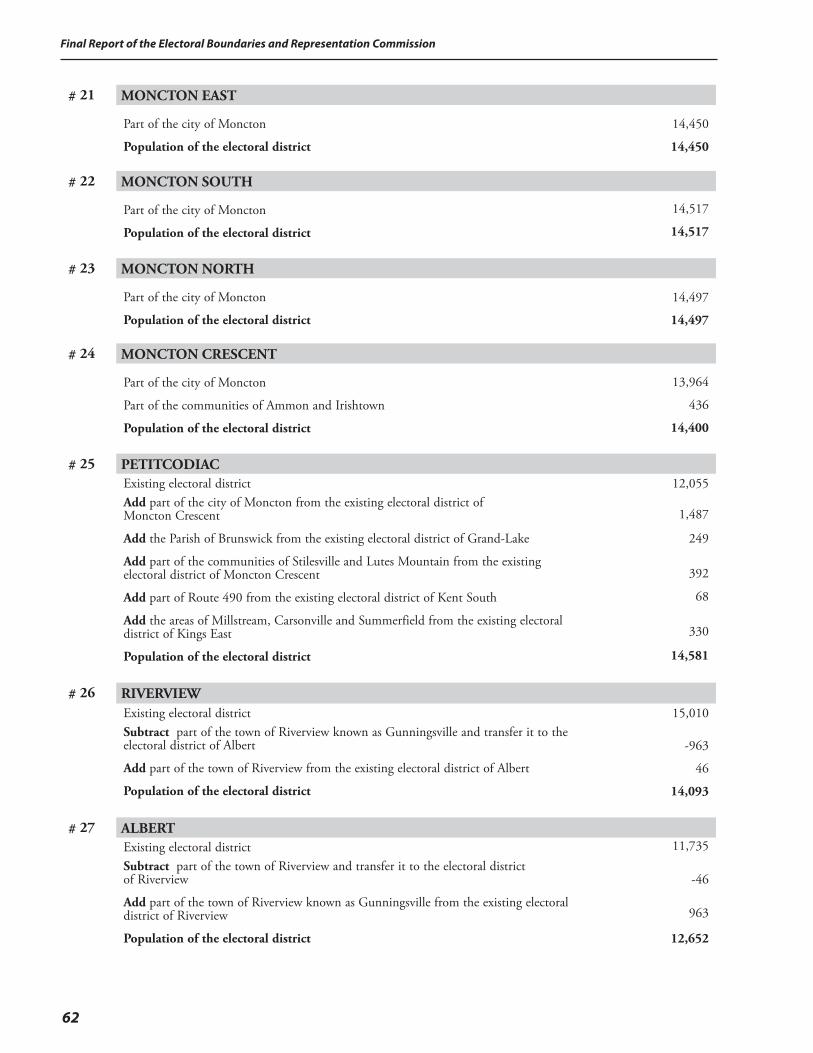
Final Report of the Electoral Boundaries and Representation Commission
62
# 21 MONCTON EAST
Part of the city of Moncton
Population of the electoral district
14,450
14,450
# 22 MONCTON SOUTH
Part of the city of Moncton
Population of the electoral district
14,517
14,517
# 23 MONCTON NORTH
Part of the city of Moncton
Population of the electoral district
14,497
14,497
# 24 MONCTON CRESCENT
Part of the city of Moncton
Part of the communities of Ammon and Irishtown
Population of the electoral district
13,964
436
14,400
# 25 PETITCODIAC Existing electoral districtAdd part of the city of Moncton from the existing electoral district of Moncton Crescent
Add the Parish of Brunswick from the existing electoral district of Grand-Lake
Add part of the communities of Stilesville and Lutes Mountain from the existing electoral district of Moncton Crescent
Add part of Route 490 from the existing electoral district of Kent South
Add the areas of Millstream, Carsonville and Summerfield from the existing electoral district of Kings East
Population of the electoral district
12,055
1,487
249
392
68
330
14,581
# 26 RIVERVIEW Existing electoral districtSubtract part of the town of Riverview known as Gunningsville and transfer it to the electoral district of Albert
Add part of the town of Riverview from the existing electoral district of Albert
Population of the electoral district
15,010
-963
46
14,093
# 27 ALBERT Existing electoral districtSubtract part of the town of Riverview and transfer it to the electoral district of Riverview
Add part of the town of Riverview known as Gunningsville from the existing electoral district of Riverview
Population of the electoral district
11,735
-46
963
12,652
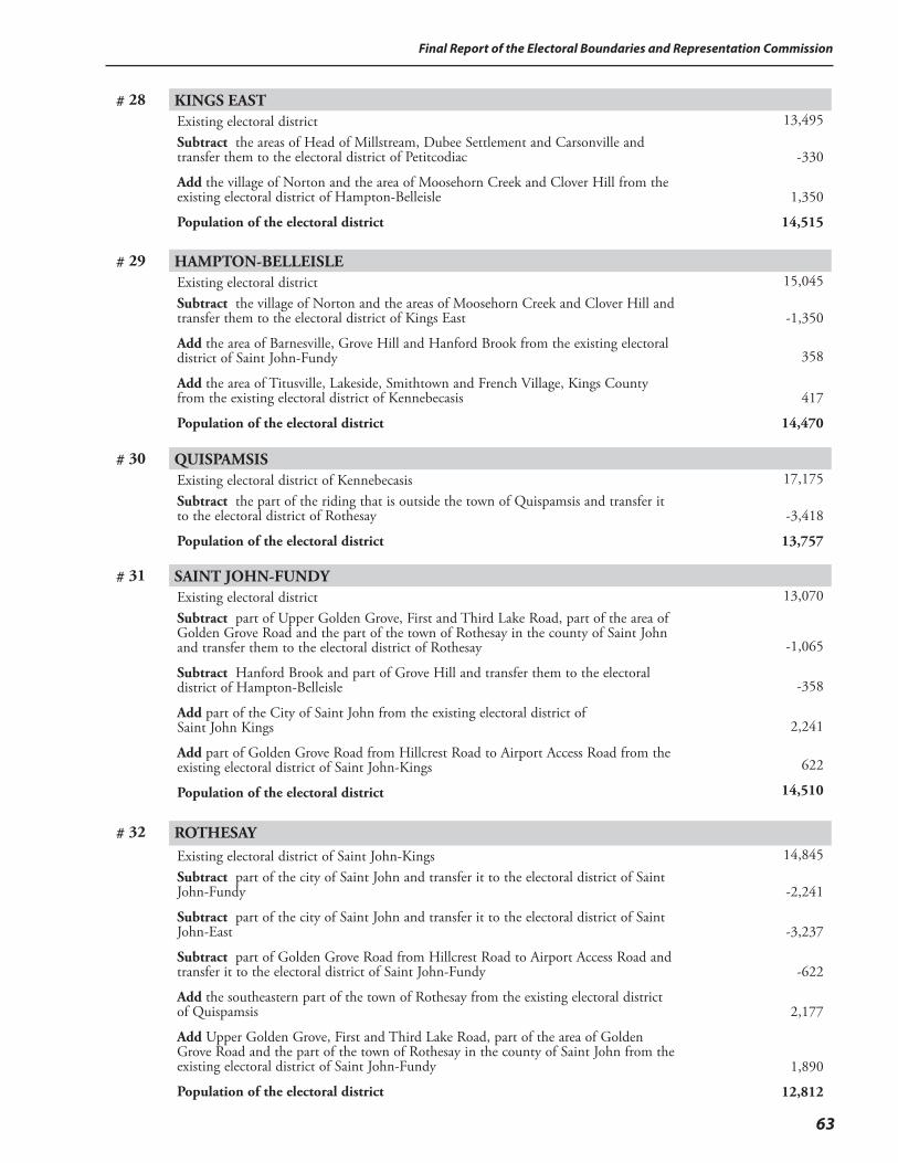
63
Final Report of the Electoral Boundaries and Representation Commission
# 28 KINGS EAST Existing electoral districtSubtract the areas of Head of Millstream, Dubee Settlement and Carsonville and transfer them to the electoral district of Petitcodiac
Add the village of Norton and the area of Moosehorn Creek and Clover Hill from the existing electoral district of Hampton-Belleisle
Population of the electoral district
13,495
-330
1,350
14,515
# 29 HAMPTON-BELLEISLE Existing electoral districtSubtract the village of Norton and the areas of Moosehorn Creek and Clover Hill and transfer them to the electoral district of Kings East
Add the area of Barnesville, Grove Hill and Hanford Brook from the existing electoral district of Saint John-Fundy
Add the area of Titusville, Lakeside, Smithtown and French Village, Kings County from the existing electoral district of Kennebecasis
Population of the electoral district
15,045
-1,350
358
417
14,470
# 30 QUISPAMSIS Existing electoral district of KennebecasisSubtract the part of the riding that is outside the town of Quispamsis and transfer it to the electoral district of Rothesay
Population of the electoral district
17,175
-3,418
13,757
# 31 SAINT JOHN-FUNDY Existing electoral districtSubtract part of Upper Golden Grove, First and Third Lake Road, part of the area of Golden Grove Road and the part of the town of Rothesay in the county of Saint John and transfer them to the electoral district of Rothesay
Subtract Hanford Brook and part of Grove Hill and transfer them to the electoral district of Hampton-Belleisle
Add part of the City of Saint John from the existing electoral district of Saint John Kings
Add part of Golden Grove Road from Hillcrest Road to Airport Access Road from the existing electoral district of Saint John-Kings
Population of the electoral district
13,070
-1,065
-358
2,241
622
14,510
# 32 ROTHESAY Existing electoral district of Saint John-KingsSubtract part of the city of Saint John and transfer it to the electoral district of Saint John-Fundy
Subtract part of the city of Saint John and transfer it to the electoral district of Saint John-East
Subtract part of Golden Grove Road from Hillcrest Road to Airport Access Road and transfer it to the electoral district of Saint John-Fundy
Add the southeastern part of the town of Rothesay from the existing electoral district of Quispamsis
Add Upper Golden Grove, First and Third Lake Road, part of the area of Golden Grove Road and the part of the town of Rothesay in the county of Saint John from the existing electoral district of Saint John-Fundy
Population of the electoral district
14,845
-2,241
-3,237
-622
2,177
1,890
12,812
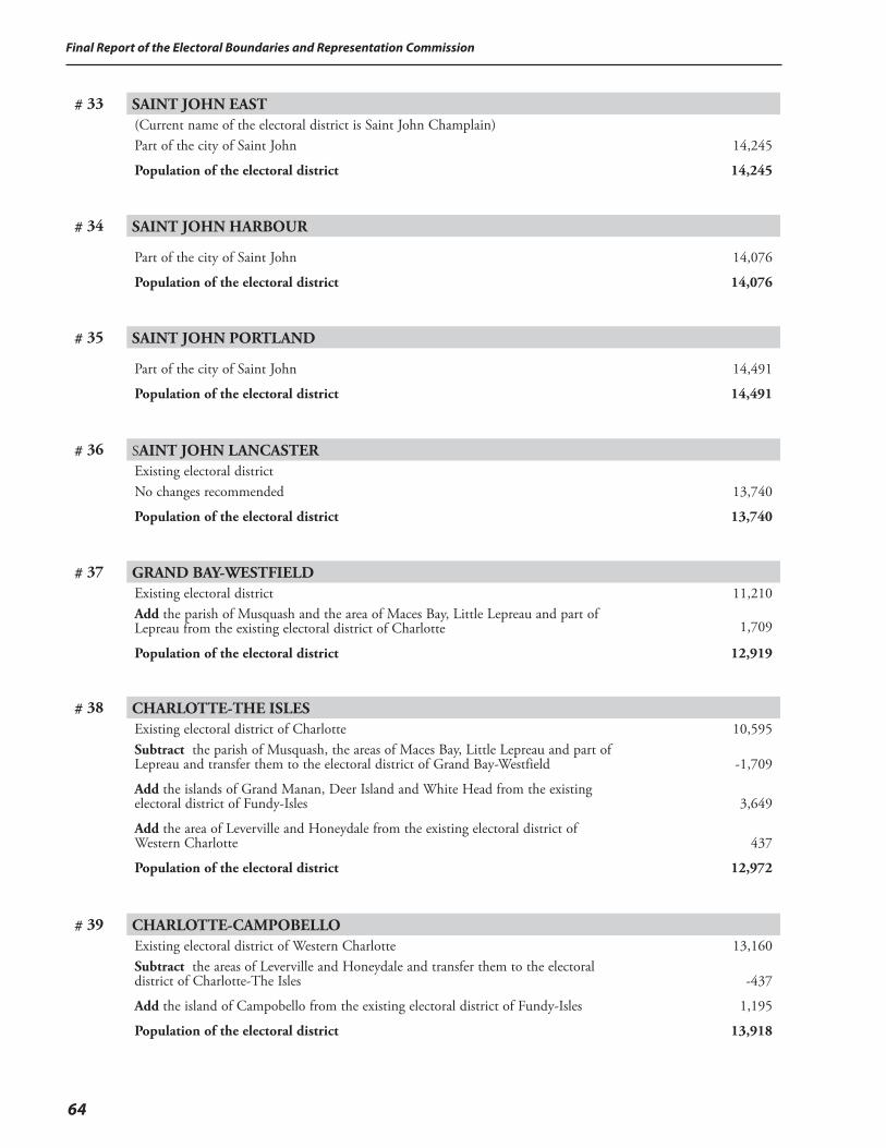
Final Report of the Electoral Boundaries and Representation Commission
64
# 33 SAINT JOHN EAST (Current name of the electoral district is Saint John Champlain)Part of the city of Saint John
Population of the electoral district
14,245
14,245
# 34 SAINT JOHN HARBOUR
Part of the city of Saint John
Population of the electoral district
14,076
14,076
# 35 SAINT JOHN PORTLAND
Part of the city of Saint John
Population of the electoral district
14,491
14,491
# 36 SAINT JOHN LANCASTER Existing electoral districtNo changes recommended
Population of the electoral district
13,740
13,740
# 37 GRAND BAY-WESTFIELD Existing electoral district
Add the parish of Musquash and the area of Maces Bay, Little Lepreau and part of Lepreau from the existing electoral district of Charlotte
Population of the electoral district
11,210
1,709
12,919
# 38 CHARLOTTE-THE ISLES Existing electoral district of CharlotteSubtract the parish of Musquash, the areas of Maces Bay, Little Lepreau and part of Lepreau and transfer them to the electoral district of Grand Bay-Westfield
Add the islands of Grand Manan, Deer Island and White Head from the existing electoral district of Fundy-Isles
Add the area of Leverville and Honeydale from the existing electoral district of Western Charlotte
Population of the electoral district
10,595
-1,709
3,649
437
12,972
# 39 CHARLOTTE-CAMPOBELLOExisting electoral district of Western CharlotteSubtract the areas of Leverville and Honeydale and transfer them to the electoral district of Charlotte-The Isles
Add the island of Campobello from the existing electoral district of Fundy-Isles
Population of the electoral district
13,160
-437
1,195
13,918
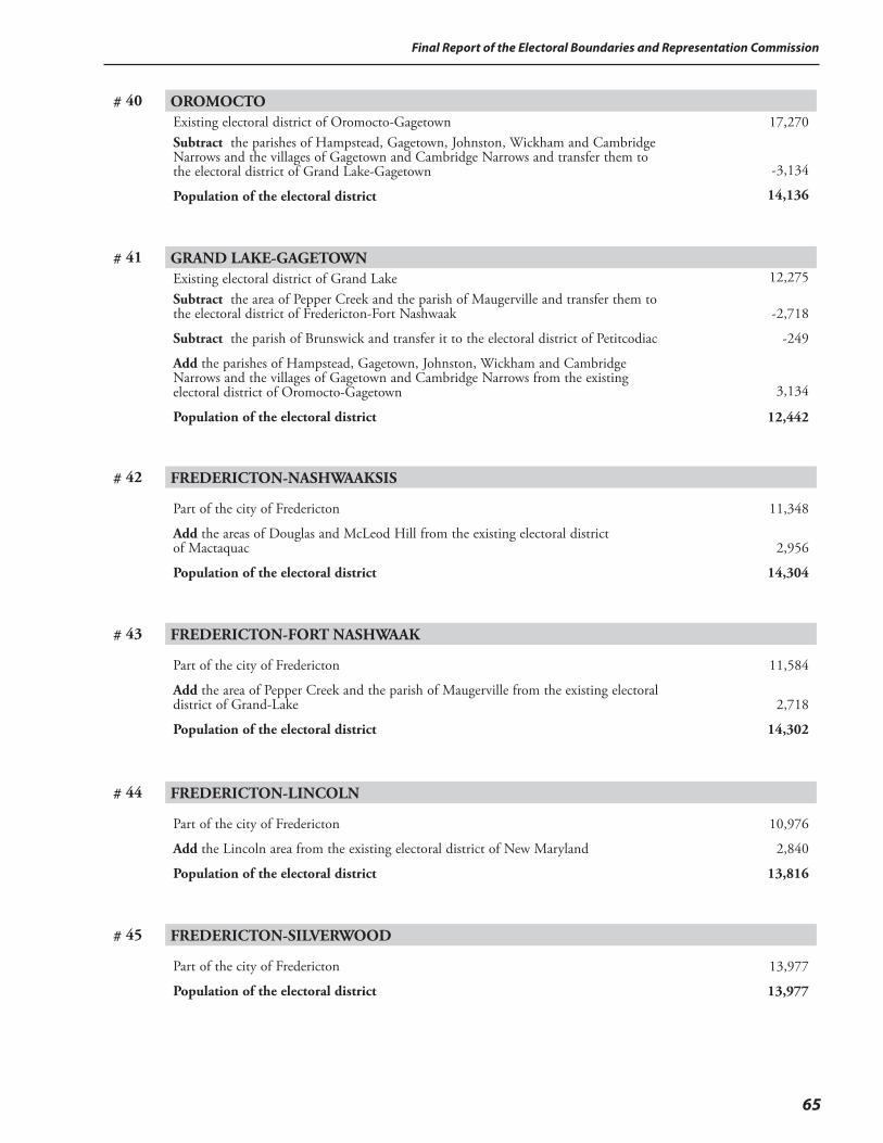
65
Final Report of the Electoral Boundaries and Representation Commission
# 40 OROMOCTO Existing electoral district of Oromocto-GagetownSubtract the parishes of Hampstead, Gagetown, Johnston, Wickham and Cambridge Narrows and the villages of Gagetown and Cambridge Narrows and transfer them to the electoral district of Grand Lake-Gagetown
Population of the electoral district
17,270
-3,134
14,136
# 41 GRAND LAKE-GAGETOWNExisting electoral district of Grand LakeSubtract the area of Pepper Creek and the parish of Maugerville and transfer them to the electoral district of Fredericton-Fort Nashwaak
Subtract the parish of Brunswick and transfer it to the electoral district of Petitcodiac
Add the parishes of Hampstead, Gagetown, Johnston, Wickham and Cambridge Narrows and the villages of Gagetown and Cambridge Narrows from the existing electoral district of Oromocto-Gagetown
Population of the electoral district
12,275
-2,718
-249
3,134
12,442
# 42 FREDERICTON-NASHWAAKSIS
Part of the city of Fredericton
Add the areas of Douglas and McLeod Hill from the existing electoral district of Mactaquac
Population of the electoral district
11,348
2,956
14,304
# 43 FREDERICTON-FORT NASHWAAK
Part of the city of Fredericton
Add the area of Pepper Creek and the parish of Maugerville from the existing electoral district of Grand-Lake
Population of the electoral district
11,584
2,718
14,302
# 44 FREDERICTON-LINCOLN
Part of the city of Fredericton
Add the Lincoln area from the existing electoral district of New Maryland
Population of the electoral district
10,976
2,840
13,816
# 45 FREDERICTON-SILVERWOOD
Part of the city of Fredericton
Population of the electoral district
13,977
13,977
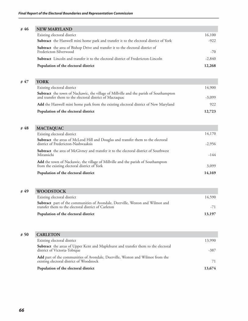
Final Report of the Electoral Boundaries and Representation Commission
66
# 46 NEW MARYLAND Existing electoral districtSubtract the Hanwell mini home park and transfer it to the electoral district of York
Subtract the area of Bishop Drive and transfer it to the electoral district of Fredericton-Silverwood
Subtract Lincoln and transfer it to the electoral district of Fredericton-Lincoln
Population of the electoral district
16,100-922
-70
-2,840
12,268
# 47 YORK Existing electoral districtSubtract the town of Nackawic, the village of Millville and the parish of Southampton and transfer them to the electoral district of Mactaquac
Add the Hanwell mini home park from the existing electoral district of New Maryland
Population of the electoral district
14,900
-3,099
922
12,723
# 48 MACTAQUAC Existing electoral districtSubtract the areas of McLeod Hill and Douglas and transfer them to the electoral district of Fredericton-Nashwaaksis
Subtract the area of McGivney and transfer it to the electoral district of Southwest Miramichi
Add the town of Nackawic, the village of Millville and the parish of Southampton from the existing electoral district of York
Population of the electoral district
14,170
-2,956
-144
3,099
14,169
# 49 WOODSTOCK Existing electoral districtSubtract part of the communities of Avondale, Deerville, Weston and Wilmot and transfer them to the electoral district of Carleton
Population of the electoral district
14,590
-71
13,197
# 50 CARLETON Existing electoral districtSubtract the areas of Upper Kent and Maplehurst and transfer them to the electoral district of Victoria-Tobique
Add part of the communities of Avondale, Deerville, Weston and Wilmot from the existing electoral district of Woodstock
Population of the electoral district
13,990
-387
71
13,674
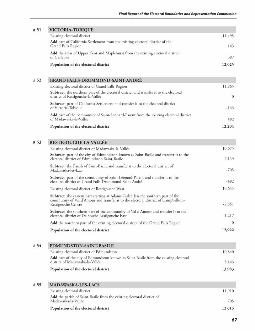
67
Final Report of the Electoral Boundaries and Representation Commission
# 51 VICTORIA-TOBIQUE Existing electoral districtAdd part of California Settlement from the existing electoral district of the Grand Falls Region
Add the areas of Upper Kent and Maplehurst from the existing electoral district of Carleton
Population of the electoral district
11,495
143
387
12,025
# 52 GRAND FALLS-DRUMMOND-SAINT-ANDRÉExisting electoral district of Grand Falls RegionSubtract the northern part of the electoral district and transfer it to the electoral district of Restigouche-la-Vallée
Subtract part of California Settlement and transfer it to the electoral district of Victoria-Tobique
Add part of the community of Saint-Léonard-Parent from the existing electoral district of Madawaska-la-Vallée
Population of the electoral district
11,865 0
-143
482
12,204
# 53 RESTIGOUCHE-LA-VALLÉEExisting electoral district of Madawaska-la-ValléeSubtract part of the city of Edmundston known as Saint-Basile and transfer it to the electoral district of Edmundston-Saint-Basile
Subtract the Parish of Saint-Basile and transfer it to the electoral district of Madawaska-les-Lacs
Subtract part of the community of Saint-Léonard-Parent and transfer it to the electoral district of Grand Falls-Drummond-Saint-André
Existing electoral district of Restigouche West
Subtract the eastern part starting at Adams Gulch less the southern part of the community of Val d’Amour and transfer it to the electoral district of Campbellton-Restigouche Centre
Subtract the southern part of the community of Val d’Amour and transfer it to the electoral district of Dalhousie-Restigouche East
Add the northern part of the existing electoral district of the Grand Falls Region
Population of the electoral district
10,675
-3,143
-705
-482
10,645
-2,851
-1,217
0
12,922
# 54 EDMUNDSTON-SAINT-BASILE Existing electoral district of EdmundstonAdd part of the city of Edmundston known as Saint-Basile from the existing electoral district of Madawaska-la-Vallée
Population of the electoral district
10,840
3,143
13,983
# 55 MADAWASKA-LES-LACS Existing electoral districtAdd the parish of Saint-Basile from the existing electoral district of Madawaska-la-Vallée
Population of the electoral district
11,910
705
12,615
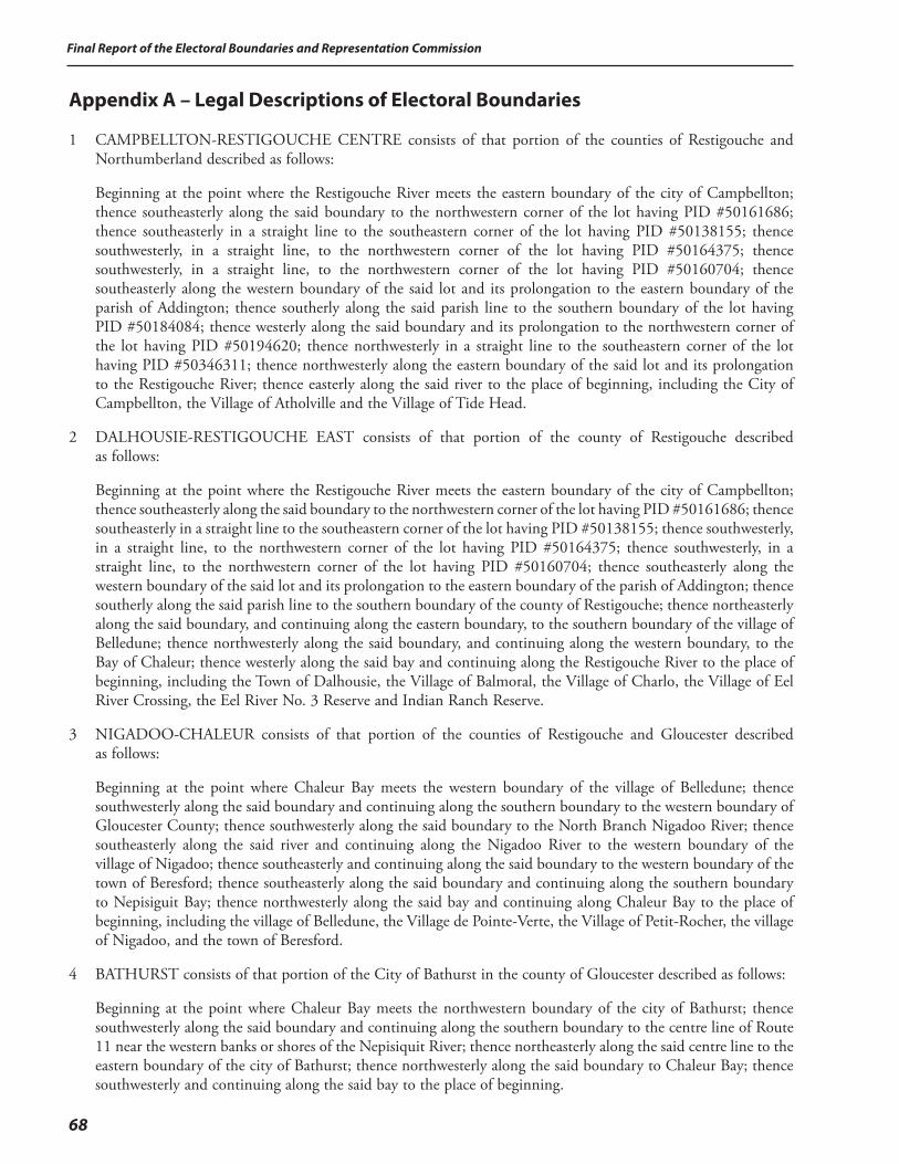
Final Report of the Electoral Boundaries and Representation Commission
68
Appendix A – Legal Descriptions of Electoral Boundaries
1 CAMPBELLTON-RESTIGOUCHE CENTRE consists of that portion of the counties of Restigouche and Northumberland described as follows:
Beginning at the point where the Restigouche River meets the eastern boundary of the city of Campbellton; thence southeasterly along the said boundary to the northwestern corner of the lot having PID #50161686; thence southeasterly in a straight line to the southeastern corner of the lot having PID #50138155; thence southwesterly, in a straight line, to the northwestern corner of the lot having PID #50164375; thence southwesterly, in a straight line, to the northwestern corner of the lot having PID #50160704; thence southeasterly along the western boundary of the said lot and its prolongation to the eastern boundary of the parish of Addington; thence southerly along the said parish line to the southern boundary of the lot having PID #50184084; thence westerly along the said boundary and its prolongation to the northwestern corner of the lot having PID #50194620; thence northwesterly in a straight line to the southeastern corner of the lot having PID #50346311; thence northwesterly along the eastern boundary of the said lot and its prolongation to the Restigouche River; thence easterly along the said river to the place of beginning, including the City of Campbellton, the Village of Atholville and the Village of Tide Head.
2 DALHOUSIE-RESTIGOUCHE EAST consists of that portion of the county of Restigouche described as follows:
Beginning at the point where the Restigouche River meets the eastern boundary of the city of Campbellton; thence southeasterly along the said boundary to the northwestern corner of the lot having PID #50161686; thence southeasterly in a straight line to the southeastern corner of the lot having PID #50138155; thence southwesterly, in a straight line, to the northwestern corner of the lot having PID #50164375; thence southwesterly, in a straight line, to the northwestern corner of the lot having PID #50160704; thence southeasterly along the western boundary of the said lot and its prolongation to the eastern boundary of the parish of Addington; thence southerly along the said parish line to the southern boundary of the county of Restigouche; thence northeasterly along the said boundary, and continuing along the eastern boundary, to the southern boundary of the village of Belledune; thence northwesterly along the said boundary, and continuing along the western boundary, to the Bay of Chaleur; thence westerly along the said bay and continuing along the Restigouche River to the place of beginning, including the Town of Dalhousie, the Village of Balmoral, the Village of Charlo, the Village of Eel River Crossing, the Eel River No. 3 Reserve and Indian Ranch Reserve.
3 NIGADOO-CHALEUR consists of that portion of the counties of Restigouche and Gloucester described as follows:
Beginning at the point where Chaleur Bay meets the western boundary of the village of Belledune; thence southwesterly along the said boundary and continuing along the southern boundary to the western boundary of Gloucester County; thence southwesterly along the said boundary to the North Branch Nigadoo River; thence southeasterly along the said river and continuing along the Nigadoo River to the western boundary of the village of Nigadoo; thence southeasterly and continuing along the said boundary to the western boundary of the town of Beresford; thence southeasterly along the said boundary and continuing along the southern boundary to Nepisiguit Bay; thence northwesterly along the said bay and continuing along Chaleur Bay to the place of beginning, including the village of Belledune, the Village de Pointe-Verte, the Village of Petit-Rocher, the village of Nigadoo, and the town of Beresford.
4 BATHURST consists of that portion of the City of Bathurst in the county of Gloucester described as follows:
Beginning at the point where Chaleur Bay meets the northwestern boundary of the city of Bathurst; thence southwesterly along the said boundary and continuing along the southern boundary to the centre line of Route 11 near the western banks or shores of the Nepisiquit River; thence northeasterly along the said centre line to the eastern boundary of the city of Bathurst; thence northwesterly along the said boundary to Chaleur Bay; thence southwesterly and continuing along the said bay to the place of beginning.

69
Final Report of the Electoral Boundaries and Representation Commission
5 NEPISIGUIT consists of that portion of the county of Gloucester described as follows:
Beginning at the point where Nepisiguit Bay meets the eastern boundary of the city of Bathurst; thence southeasterly along the said boundary to the centre line of Route 11; thence southwesterly and continuing along the said centre line to the southern boundary of the city of Bathurst; thence northwesterly and continuing along the said boundary and along the western boundary to the western boundary of the town of Beresford; thence northwesterly and continuing along the said boundary to the southern boundary of the village of Nigadoo; thence southwesterly and continuing along the western boundary of the said village to the Nigadoo River; thence northwesterly and continuing along the North Branch Nigadoo River to the western boundary of the county of Gloucester; thence southwesterly along the said boundary and continuing along the southern boundary to the western boundary of the parish of Saumarez; thence northwesterly along the said boundary to the northwestern corner of the said parish; thence northwesterly in a straight line to the southwestern corner of the lot having PID #20299947; thence northwesterly along the western boundary of the said lot and its prolongation to the southern boundary of the lot having PID #20404984; thence northeasterly along the said boundary to the southern boundary of the parish of New Bandon; thence northeasterly along the said boundary and continuing along the eastern boundary to the southwestern corner of the lot having PID #20521928; thence northwesterly along the western boundary of the said lot and its prolongation to the southern boundary of the lot having PID #20076477; thence northeasterly along the said boundary and its prolongation to the Caraquet River; thence northeasterly along the said river to the southeasterly prolongation of the western boundary of the lot having PID #20514212; thence northwesterly along the said prolongation to the southwestern corner of the said lot, also being a point on the eastern boundary of the lot having PID #20142279; thence northwesterly and continuing along the said eastern boundary to the eastern boundary of the lot having PID #20084778; thence northwesterly along the said boundary and its prolongation to the southern boundary of the lot having PID #20141834; thence northeasterly along the said boundary and its prolongation to the centre line of Route 135; thence northwesterly along the said centre line to the southwesterly prolongation of the southern boundary of the lot having PID #20738720; thence northeasterly along the said prolongation and boundary to the western boundary of the village of Saint-Léolin; thence northwesterly along the said boundary and continuing along the northern boundary to the western boundary of the village of Grande-Anse; thence northwesterly and continuing along the said boundary to Chaleur Bay; thence southwesterly and continuing along the said bay to the place of beginning, including a portion of the City of Bathurst and Pabineau No. 11 Reserve.
6 CARAQUET consists of that portion of the county of Gloucester described as follows:
Beginning at the point where Chaleur Bay meets the western boundary of the village of Grande-Anse; thence southeasterly and continuing along the said western boundary to the northern boundary of the village of Saint-Léolin; thence southwesterly along the said boundary and continuing along the western boundary to the southeastern corner of the lot having PID #20738720; thence southwesterly along the southern boundary of the said lot and its prolongation to the centre line of Route 135; thence southeasterly along the said centre line to meet the northeasterly prolongation of the southern boundary of the lot having PID #20141834; thence southwesterly along the said prolongation and boundary to the northwesterly prolongation of the eastern boundary of the lot having PID #20084778; thence southeasterly along the said prolongation and boundary to the Caraquet River; thence northeasterly and continuing along the said river to the northwestern corner of the lot having PID #20114757; thence southeasterly along the western boundary of the said lot and its prolongation to the northwestern corner of the lot having PID #20104824; thence northeasterly along the northern boundary of the said lot and its prolongation to the northwestern corner of the lot having PID #20542148; thence southeasterly along the western boundary of the said lot and its prolongation to the southwesterly prolongation of the northern boundary of the lot having PID #20103560; thence northeasterly along the said prolongation and boundary and its prolongation to the western boundary of the village of Bertrand; thence southeasterly along the said boundary and continuing along the southern boundary to the western boundary of the parish of Caraquet; thence southeasterly and continuing along the said boundary to the southern boundary of the Local Service District of St. Simon; thence northeasterly along the said boundary to Baie-Saint-Simon-Sud; thence northerly along the said bay and continuing along Baie de Shippagan, between the islands of Pokesudie and Lamèque, to Chaleur Bay; thence westerly along Chaleur Bay to the place of beginning, including the Town of Caraquet, the villages of Grande-Anse, Saint-Léolin, Bertrand, Maisonnette, and the Village of Bas-Caraquet.
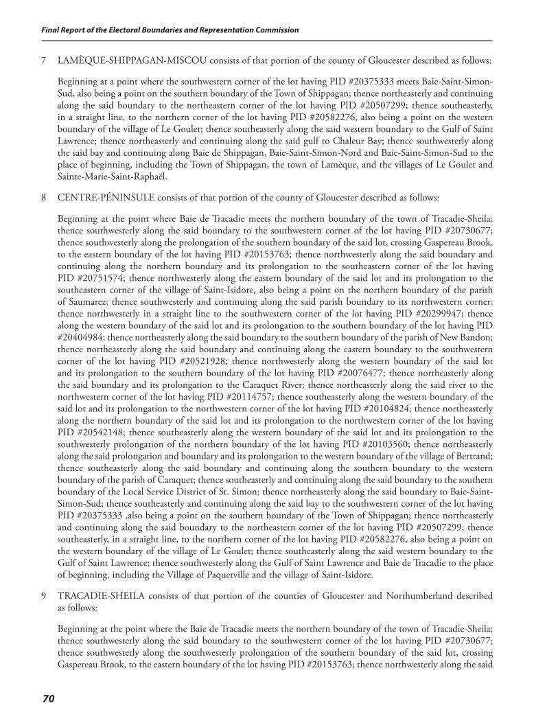
Final Report of the Electoral Boundaries and Representation Commission
70
7 LAMÈQUE-SHIPPAGAN-MISCOU consists of that portion of the county of Gloucester described as follows:
Beginning at a point where the southwestern corner of the lot having PID #20375333 meets Baie-Saint-Simon-Sud, also being a point on the southern boundary of the Town of Shippagan; thence northeasterly and continuing along the said boundary to the northeastern corner of the lot having PID #20507299; thence southeasterly, in a straight line, to the northern corner of the lot having PID #20582276, also being a point on the western boundary of the village of Le Goulet; thence southeasterly along the said western boundary to the Gulf of Saint Lawrence; thence northeasterly and continuing along the said gulf to Chaleur Bay; thence southwesterly along the said bay and continuing along Baie de Shippagan, Baie-Saint-Simon-Nord and Baie-Saint-Simon-Sud to the place of beginning, including the Town of Shippagan, the town of Lamèque, and the villages of Le Goulet and Sainte-Marie-Saint-Raphaël.
8 CENTRE-PÉNINSULE consists of that portion of the county of Gloucester described as follows:
Beginning at the point where Baie de Tracadie meets the northern boundary of the town of Tracadie-Sheila; thence southwesterly along the said boundary to the southwestern corner of the lot having PID #20730677; thence southwesterly along the prolongation of the southern boundary of the said lot, crossing Gaspereau Brook, to the eastern boundary of the lot having PID #20153763; thence northwesterly along the said boundary and continuing along the northern boundary and its prolongation to the southeastern corner of the lot having PID #20751574; thence northwesterly along the eastern boundary of the said lot and its prolongation to the southeastern corner of the village of Saint-Isidore, also being a point on the northern boundary of the parish of Saumarez; thence southwesterly and continuing along the said parish boundary to its northwestern corner; thence northwesterly in a straight line to the southwestern corner of the lot having PID #20299947; thence along the western boundary of the said lot and its prolongation to the southern boundary of the lot having PID #20404984; thence northeasterly along the said boundary to the southern boundary of the parish of New Bandon; thence northeasterly along the said boundary and continuing along the eastern boundary to the southwestern corner of the lot having PID #20521928; thence northwesterly along the western boundary of the said lot and its prolongation to the southern boundary of the lot having PID #20076477; thence northeasterly along the said boundary and its prolongation to the Caraquet River; thence northeasterly along the said river to the northwestern corner of the lot having PID #20114757; thence southeasterly along the western boundary of the said lot and its prolongation to the northwestern corner of the lot having PID #20104824; thence northeasterly along the northern boundary of the said lot and its prolongation to the northwestern corner of the lot having PID #20542148; thence southeasterly along the western boundary of the said lot and its prolongation to the southwesterly prolongation of the northern boundary of the lot having PID #20103560; thence northeasterly along the said prolongation and boundary and its prolongation to the western boundary of the village of Bertrand; thence southeasterly along the said boundary and continuing along the southern boundary to the western boundary of the parish of Caraquet; thence southeasterly and continuing along the said boundary to the southern boundary of the Local Service District of St. Simon; thence northeasterly along the said boundary to Baie-Saint-Simon-Sud; thence southeasterly and continuing along the said bay to the southwestern corner of the lot having PID #20375333 ,also being a point on the southern boundary of the Town of Shippagan; thence northeasterly and continuing along the said boundary to the northeastern corner of the lot having PID #20507299; thence southeasterly, in a straight line, to the northern corner of the lot having PID #20582276, also being a point on the western boundary of the village of Le Goulet; thence southeasterly along the said western boundary to the Gulf of Saint Lawrence; thence southwesterly along the Gulf of Saint Lawrence and Baie de Tracadie to the place of beginning, including the Village of Paquetville and the village of Saint-Isidore.
9 TRACADIE-SHEILA consists of that portion of the counties of Gloucester and Northumberland described as follows:
Beginning at the point where the Baie de Tracadie meets the northern boundary of the town of Tracadie-Sheila; thence southwesterly along the said boundary to the southwestern corner of the lot having PID #20730677; thence southwesterly along the southwesterly prolongation of the southern boundary of the said lot, crossing Gaspereau Brook, to the eastern boundary of the lot having PID #20153763; thence northwesterly along the said
71
Final Report of the Electoral Boundaries and Representation Commission
boundary and continuing along the northern boundary and its prolongation to the southeastern corner of the lot having PID #20751574; thence northwesterly along the eastern boundary of the said lot and its prolongation to the southeastern corner of the village of Saint-Isidore, also being a point on the northern boundary of the parish of Saumarez; thence southwesterly and continuing along the said boundary and along the western and southern boundaries to the western boundary of the Tracadie Military Area; thence southeasterly and continuing along the said boundary to the Riviere du Portage; thence northeasterly along the said river to the northwesterly prolongation of the eastern boundary of the lot having PID #42269896; thence southeasterly along the said prolongation and boundary to the northwestern corner of the lot having PID #40267668; thence southeasterly along the northern boundary of the said lot and its prolongation to the western boundary of the lot having PID #40267643; thence northwesterly along the said boundary and continuing along the northern and eastern boundaries to the southeastern corner of the said lot; thence northeasterly in a straight line to the northwestern corner of the lot having PID #40269748; thence northeasterly, in a straight line, to the northwestern corner of the lot having PID #40269201; thence southeasterly along the northern boundary of the said lot to the Gulf of St. Lawrence; thence northerly along the Gulf of St. Lawrence and the Baie de Tracadie to the place of beginning, including the town of Tracadie-Sheila.
10 MIRAMICHI BAY consists of that portion of the county of Northumberland described as follows:
Beginning at the point where the Miramichi River meets the eastern boundary of the lot having PID #40372823; thence northwesterly along the said boundary to the southern boundary of the lot having PID #40120560; thence southwesterly along the said boundary to the southwestern corner of the said lot; thence northwesterly, in a straight line, to the northeastern corner of the lot having PID #40330532; thence southwesterly along the northern boundary of the said lot and its prolongation to the eastern boundary of the lot having PID #40120701; thence northwesterly along the said boundary and its prolongation to the southeastern corner of the lot having PID #40396756; thence northwesterly along the eastern boundary of the said lot and continuing along its northern and western boundaries and to the southeastern corner of the lot having PID #40084048; thence southwesterly along the southern boundary of the said lot and continuing along its western boundary and its prolongation to the northeastern corner of the lot having PID #40432726; thence southwesterly along the northern boundary of the said lot to the southeastern corner of the lot having PID #40334872; thence northwesterly along the eastern boundary of the said lot to its northeastern corner; thence northwesterly, in a straight line, to the southeastern corner of the lot having PID #40184640; thence northwesterly along the eastern boundary of the said lot and its prolongation to the northern boundary of the city of Miramichi; thence southwesterly and continuing along the said boundary to a point on the eastern boundary of the lot having PID #40114001; thence northwesterly, in a straight line, to the point where the eastern limits of Bellefond Road are intersected by Ox Brook; thence northwesterly along the brook to the western boundary of the parish of Newcastle; thence northwesterly along the said boundary to the northern boundary of the county of Northumberland; thence easterly along the said northern boundary to the western boundary of the Tracadie Military Area; thence southeasterly and continuing along the said boundary to the Riviere du Portage; thence northeasterly along the said river to the northwesterly prolongation of the eastern boundary of the lot having PID #42269896; thence southeasterly along the said prolongation and boundary to the northwestern corner of the lot having PID #40267668; thence southeasterly along the northern boundary of the said lot and its prolongation to the western boundary of the lot having PID #40267643; thence northwesterly along the said boundary and continuing along the northern and eastern boundaries to the southeastern corner of the said lot; thence northeasterly in a straight line to the northwestern corner of the lot having PID #40269748; thence northeasterly, in a straight line, to the northwestern corner of the lot having PID #40269201; thence southeasterly along the northern boundary of the said lot to the Gulf of St. Lawrence; thence southwesterly along the Gulf of St. Lawrence and continuing along Miramichi Bay and the Miramichi River to the place of beginning, including a portion of the city of Miramichi, the village of Neguac, Burnt Church No. 14 Reserve and Tabusintac No. 9 Reserve.
11 MIRAMICHI-BAY DU VIN consists of that portion of the county of Northumberland described as follows:
Beginning at the point where Northumberland Strait meets the southeastern boundary of the county of Northumberland; thence southwesterly along the said boundary to the western boundary of the parish of
Final Report of the Electoral Boundaries and Representation Commission
72
Glenelg; thence northwesterly and continuing along the said boundary to the southern boundary of the city of Miramichi; thence northeasterly and continuing along the said boundary to the southeastern corner of the lot having PID #40264707; thence northwesterly along the eastern boundary of the said lot to its northeastern corner; thence northeasterly in a straight line to the southeastern corner of the lot having PID #40259319; thence northwesterly along the eastern boundary of the said lot and its prolongation to the centre line of the Canadian National Railways ; thence southwesterly along the said centre line to the centre line of Bridge Road; thence northwesterly along the said centre line to the eastern boundary of the lot having PID #40323255; thence northwesterly along the said boundary and its prolongation to the eastern boundary of the lot having PID #40261844; thence northeasterly along the said boundary and its prolongation to the southeasterly prolongation of the eastern boundary of the lot having PID #40262263; thence northwesterly along the said prolongation and boundary and its prolongation to a point on the Miramichi River; thence northeasterly along the said river and continuing along Miramichi Bay and Northumberland Strait to the place of beginning, including a portion of the city of Miramichi.
12 MIRAMICHI CENTRE consists of that portion of the county of Northumberland described as follows:
Beginning at the point where the Miramichi River meets the eastern boundary of the lot having PID #40372823; thence northwesterly along the said boundary to the southern boundary of the lot having PID #40120560; thence southwesterly along the said boundary to the southwestern corner of the said lot; thence northwesterly, in a straight line, to the northeastern corner of the lot having PID #40330532; thence southwesterly along the northern boundary of the said lot and its prolongation to the eastern boundary of the lot having PID #40120701; thence northwesterly along the said boundary and its prolongation to the southeastern corner of the lot having PID #40396756; thence northwesterly along the eastern boundary of the said lot and continuing along its northern and western boundaries to the southeastern corner of the lot having PID #40084048; thence southwesterly along the southern boundary of the said lot and continuing along its western boundary and its prolongation to the northeastern corner of the lot having PID #40432726; thence southwesterly along the northern boundary of the said lot to the southeastern corner of the lot having PID #40334872; thence northwesterly along the eastern boundary of the said lot to its northeastern corner; thence northwesterly, in a straight line, to the southeastern corner of the lot having PID #40184640; thence northwesterly along the eastern boundary of the said lot and its prolongation to the northern boundary of the city of Miramichi; thence southwesterly and continuing along the said boundary to a point on the eastern boundary of the lot having PID #40114001; thence northwesterly, in a straight line, to the point where the eastern limits of Bellefond Road are intersected by Ox Brook; thence northwesterly along the said brook to the western boundary of the parish of Newcastle; thence northwesterly along the said boundary to the northern boundary of the county of Northumberland; thence southwesterly along the said boundary and continuing along the eastern and northern boundaries to the southwestern corner of the parish of Balmoral; thence southerly along the southerly prolongation of the western boundary of the said parish to a point on the northern boundary of the lot having PID #40216483; thence westerly along the said boundary and its prolongation to the western boundary of the parish of Northesk; thence southeasterly along the said boundary and continuing along the western and southern boundaries to the Little South West Miramichi River; thence southeasterly and continuing along the said river and along the Northwest Miramichi River and the Southwest Miramichi River to the northwesterly prolongation of the western boundary of Miramichi; thence southeasterly along the said prolongation and boundary and continuing along the western and southern boundaries to the southeastern corner of the lot having PID #40264707; thence northwesterly along the eastern boundary of the said lot to its northeastern corner; thence northeasterly, in a straight line, to the southeastern corner of the lot having PID #40259319; thence northwesterly along the eastern boundary of the said lot and its prolongation to the centre line of the Canadian National Railways; thence southwesterly along the said centre line to the centre line of Bridge Road.; thence northwesterly along the said centre line to the eastern boundary of the lot having PID #40323255; thence northwesterly along the said boundary and its prolongation to the eastern boundary of the lot having PID #40261844; thence northeasterly along the said boundary and its prolongation to the southeasterly prolongation of the eastern boundary of the lot having PID #40262263; thence northwesterly along the said prolongation and boundary and its prolongation to the Miramichi River; thence northeasterly along the said river to the place of beginning, including a portion of the city of Miramichi, Eel Ground No. Reserve and Big Hole Tract No. 8 Reserve.

73
Final Report of the Electoral Boundaries and Representation Commission
13 SOUTHWEST MIRAMICHI consists of that portion of the counties of York and Northumberland described as follows:
Beginning at a point where the western boundary of the county of Northumberland meets the western boundary of the county of York; thence southwesterly along the York County boundary to the eastern boundary of the parish of Douglas; thence southeasterly along the said boundary to the South Branch Taxis River; thence northeasterly and continuing along the said river to the northeasterly prolongation of the western boundary of the lot having PID #75184887; thence southwesterly along the said prolongation and boundary and its prolongation to Cross Creek; thence southeasterly and continuing along the said creek to the southwestern corner of the lot having PID #75126110; thence easterly along the southern boundary of the said lot and its prolongation to the southern boundary of the parish of Stanley; thence northeasterly along the said boundary to the eastern boundary of the county of York; thence northeasterly along the said boundary to the southern boundary of the county of Northumberland; thence southeasterly along the said boundary and continuing along the eastern boundary to the southwestern corner of the parish of Rogersville; thence northwesterly along the western boundary of the said parish and continuing along its northern boundary to the southern boundary of the lot having PID #40153132, also being a point on the eastern boundary of the lot having PID #40094740; thence northwesterly and continuing along the said eastern boundary to the southwestern corner of the lot having PID #40368573; thence northwesterly along the western boundary of the said lot and its prolongation to the southwesterly prolongation of the northern boundary of the lot having PID #40093494; thence northeasterly along the said prolongation and boundary and its prolongation to meet the eastern boundary of the parish of Nelson; thence northwesterly along the said boundary to the southern boundary of the city of Miramichi; thence southwesterly along the said boundary and continuing along the western boundary and its prolongation to the Southwest Miramichi River; thence northwesterly along the said river and continuing along the Northwest Miramichi River and the Little Southwest Miramichi River to the southern boundary of the parish of Northesk near the northern end of Johnson’s Island; thence northwesterly along the said boundary to the western boundary of the county of Northumberland; thence southeasterly along the said boundary to the place of beginning, including the Village of Blackville, the Village of Doaktown Red Bank No. 7 Reserve and Red Bank No.4 Reserve.
14 ROGERSVILLE-KOUCHIBOUGUAC consists of that portion of the counties of Northumberland and Kent described as follows:
Beginning at the point where Northumberland Strait meets the northern boundary of the lot having PID # 25254574; thence northwesterly along the said northern boundary and its prolongation to the northwestern corner of the lot having PID #25137399; thence southwesterly, in a straight line, to the southeastern corner of the lot having PID #25361643; thence southwesterly along the southern boundary of the said lot and its prolongation to the centre line of Route 11; thence northwesterly along the said centre line to the southern boundary of Richibucto; thence southwesterly along the said boundary and continuing along its western boundary to the southern boundary of the parish of Saint Charles; thence southwesterly along the said boundary to the southern boundary of the parish of Saint-Louis; thence westerly along the said boundary and continuing along the southern and western boundaries of the parish of Acadieville and the western and northern boundaries of the parish of Rogersville to southwestern boundary of the lot having PID #40153132, also being a point on the eastern boundary of the lot having PID #40094740; thence northwesterly and continuing along the said eastern boundary to the southwestern corner of the lot having PID #40368573; thence northwesterly along the western boundary of the said lot and its prolongation to the southwesterly prolongation of the northern boundary of the lot having PID #40093494; thence northeasterly along the said prolongation and boundary and its prolongation to meet the eastern boundary of the parish of Glenelg; thence southeasterly and continuing along the said boundary to the southern boundary of the county of Northumberland; thence northeasterly along the said boundary to Northumberland Strait; thence southerly along the said strait to the place of beginning, including the town of Richibucto, the village of Rogersville, the village of Saint-Louis de Kent, and Indian Island No. 28 Reserve.
Final Report of the Electoral Boundaries and Representation Commission
74
15 KENT consists of that portion of the county of Kent described as follows:
Beginning at the point where Northumberland Strait meets the northern boundary of the lot having PID # 25254574; thence northwesterly along the said northern boundary and its prolongation to the northwestern corner of the lot having PID #25137399; thence southwesterly, in a straight line, to the southeastern corner of the lot having PID #25361643; thence southwesterly along the southern boundary of the said lot and its prolongation to the centre line of Route 11; thence northwesterly along the said centre line to the southern boundary of Richibucto; thence southwesterly along the said boundary and continuing along its western boundary to the southern boundary of the parish of Saint Charles; thence southwesterly along the said boundary to the southern boundary of the parish of Saint-Louis; thence westerly along the said boundary and continuing along the southern and western boundaries of the parish of Acadieville to the western boundary of the county of Kent; thence southwesterly along the said boundary to the southwestern corner of the parish of Blackville; thence southeasterly, in a straight line, to the northeastern corner of the lot having PID #25208372; thence southerly along the eastern boundary of the said lot and its prolongation to the southern boundary of the county of Kent; thence southeasterly and continuing along the said boundary to the southern boundary of the lot having PID #00946061 also being a point on the northern boundary of a Crown reserved road; thence northeasterly along the said boundary to the southwestern corner of the lot having PID #25236548; thence northwesterly, in a straight line, to the northeastern corner of the lot having PID #25047523; thence northeasterly, in a straight line, to the southeastern corner of the lot having PID #25046004; thence northwesterly along the eastern boundary of the said lot to a point 150 meters south of the southern limits of Cotes Mills South rd; thence northeasterly parallel to and maintaining a distance of 150 meters from the said southern limits and continuing at the same distance from ch Saint-Joseph to the eastern boundary of the lot having PID #25045808, thence southeasterly along the said boundary to the northeastern corner of the lot having PID #25126558; thence northeasterly, in a straight line, to the northwestern corner of the lot having PID #25059858; thence southeasterly along the northern boundary of the said lot and its prolongation to a point 150 meters northwest of the northwestern limits of Sheridan Rd; thence northeasterly, parallel to and maintaining a distance of 150 meters from the said limits to the western boundary of Bouctouche; thence southeasterly along the said boundary and its prolongation to the Little Buctouche River; thence northeasterly along the said river to Buctouche Bay; thence northerly along Buctouche Bay, Buctouche Harbour and Northumberland Strait to the place of beginning, including the town of Bouctouche, the Village of Rexton, Richibucto No. 15 Reserve and Bouctouche No.16 Reserve.
16 KENT SOUTH consists of that portion of the counties of Kent and Westmorland described as follows:
Beginning at a point where Shediac Harbour meets the northern boundary of the town of Shediac; thence southwesterly along the said boundary and continuing along the western boundary to the centre line of Route 15; thence westerly and continuing along the said centre line to the western boundary of the parish of Shediac; thence northwesterly along the said boundary to the southern boundary of the lot having PID #70008677; thence southwesterly along the said boundary and its prolongation to the southwestern corner of the lot having PID #70008768; thence northwesterly along the western boundary of the said lot and its prolongation to the centre line of Bateman Mill Road; thence southwesterly along the said centre line and continuing along the centre line of Weisner Road to the southeasterly prolongation of the eastern boundary of the lot having PID #70187828; thence northwesterly along the said prolongation and eastern boundary to the northeastern corner of the said lot; thence southwesterly, in a straight line, to the northwestern corner of the lot having PID #00932954; thence southwesterly, in a straight line, to the southeastern corner of the lot having PID #01043389, also being a point on the northeastern boundary of the City of Moncton; thence southwesterly and continuing along the said boundary to a point 100 meters west of the western limits of Route 115 (Irishtown Road); thence northwesterly, parallel to and maintaining a distance of 100 meters from the said limits to the southern boundary of the lot having PID #00931402, excepting the properties fronting on Ammon Road and Valley Ranch Road; thence southwesterly along the said boundary and its prolongation to a point 150 meters east of the eastern limits of Route 490 (McLaughlin Road); thence northwesterly, parallel to and maintaining a distance of 150 meters from the said eastern limits to the northern boundary of Westmorland County, including the properties fronting on Communication Road; thence easterly along the said boundary to the southern boundary of the lot
75
Final Report of the Electoral Boundaries and Representation Commission
having PID #00946061 also being a point on the northern boundary of a Crown reserved road; thence northeasterly along the said boundary to the southwestern corner of the lot having PID #25236548; thence northwesterly, in a straight line, to the northeastern corner of the lot having PID #25047523; thence northeasterly, in a straight line, to the southeastern corner of the lot having PID #25046004; thence northwesterly along the eastern boundary of the said lot to a point 150 meters south of the southern limits of Coates Mills South rd; thence northeasterly parallel to and maintaining a distance of 150 meters from the said southern limits and continuing at the same distance from Saint-Joseph Road to the eastern boundary of the lot having PID #25045808, thence southeasterly along the said boundary to the northeastern corner of the lot having PID #25126558; thence northeasterly, in a straight line, to the northwestern corner of the lot having PID #25059858; thence southeasterly along the northern boundary of the said lot and its prolongation to a point 150 meters northwest of the northwestern limits of Sheridan Rd; thence northeasterly, parallel to and maintaining a distance of 150 meters from the said limits to the western boundary of the town of Bouctouche; thence southeasterly along the said boundary and its prolongation to Little Buctouche River; thence northeasterly along the said river to Buctouche Bay; thence along Bouctouche Bay, Northumberland Strait and Shediac Harbour to the place of beginning, including the Village de Saint-Antoine.
17 SHEDIAC-CAP-PELÉ consists of that portion of the county of Westmorland described as follows:
Beginning at a point where Shediac Harbour meets the northern boundary of the town of Shediac; thence southwesterly and continuing along the western and southern boundaries of the said town to the Scoudouc River; thence southeasterly along the said river to the southwestern corner of the lot having PID #00885467; thence northeasterly along the southern boundary of the said lot to the southeastern corner of the lot having PID #01046689; thence northeasterly along the southern boundary of the said lot to the western boundary of the rural community of Beaubassin East; thence southeasterly and continuing along the said boundary and along the southern and eastern boundaries to Shemogue Harbour; thence northerly along Shemogue Harbour and continuing along Northumberland Strait and Shediac Harbour to the place of beginning, including the town of Shediac, the Village de Cap-Pelé and the Beaubassin East Rural Community.
18 TANTRAMAR consists of that portion of the county of Westmorland described as follows:
Beginning at the point where Shemogue Harbour meets the eastern boundary of the rural community of Beaubassin East; thence southerly and continuing along the said boundary and along the southern boundary to the western boundary of the parish of Sackville; thence southeasterly along the said boundary to the southern boundary of the village of Memramcook; thence southwesterly along the said boundary to the Memramcook River; thence southerly along the said river and continuing along Shepody Bay to Cumberland Basin; thence northeasterly along Cumberland Basin to the provincial boundary between the Provinces of Nova Scotia and New Brunswick; thence along the said provincial boundary to Northumberland Strait; thence northeasterly and continuing along the said strait and Shemogue Harbour to the place of beginning, including the Town of Sackville, the Village of Dorchester, the Village of Port Elgin and Fort Folly No. 11 Reserve.
19 MEMRAMCOOK-LAKEVILLE-DIEPPE consists of that portion of the county of Westmorland described as follows:
Beginning at the point where the western boundary of the town of Shediac meets the centre line of Route 15; thence westerly and continuing along the said centre line to the western boundary of the parish of Shediac; thence northwesterly along the said boundary to the southern boundary of the lot having PID #70008677; thence southwesterly along the said boundary and its prolongation to the southwestern corner of the lot having PID #70008768; thence northwesterly along the western boundary of the said lot and its prolongation to the centre line of Bateman Mill Road; thence southwesterly along the said centre line and continuing along the centre line of Weisner Road to the southeasterly prolongation of the eastern boundary of the lot having PID #70187828; thence northwesterly along the said prolongation and boundary to the northeastern corner of the said lot; thence southwesterly, in a straight line, to the northwestern corner of the lot having PID #00932954; thence southwesterly, in a straight line, to the southeastern corner of the lot having PID #01043389, also being a point on the northern boundary of the City of Moncton; thence southeasterly along the said boundary to Humphrey’s Brook; thence northeasterly along the said
Final Report of the Electoral Boundaries and Representation Commission
76
brook to the northwesterly prolongation of the eastern boundary of the lot having PID #00930479; thence southeasterly along the said prolongation and boundary and its prolongation to the centre line of Route 2; thence southwesterly along the said centre line to the centre line of Harrisville Boulevard; thence southeasterly along the said centre line to the centre line of Dieppe Boulevard; thence southeasterly along the said centre line to the centre line of Champlain Street; thence northeasterly and continuing along the said centre line to the centre line of Lorette Street; thence southerly along the said centre line to the westerly prolongation of the northern boundary of the lot having PID #00925982; thence easterly along the said prolongation and boundary to the western boundary of the lot having PID # 00926303; thence southerly along the said boundary and continuing along the southern boundary to the western boundary of the lot having PID #01014760; thence southwesterly along the said boundary and continuing along the southern boundary and its prolongation to the eastern boundary of the lot having PID #00926824; thence southwesterly along the said boundary to the southeastern corner of the said lot; thence southwesterly, in a straight line, to the point where the eastern boundary of the city of Dieppe meets the centre line of Melanson Road; thence southwesterly along the said centre line and its prolongation to the Petitcodiac River; thence southeasterly along the said river and continuing northerly along the Memramcook River to the southern boundary of the village of Memramcook; thence northeasterly along the said boundary and continuing along the eastern boundary and its prolongation to the southern boundary of the parish of Shediac; thence northeasterly along the said boundary to the southwestern corner of the rural community of Beaubassin East; thence northwesterly and continuing along the western boundary of the said rural community to the southeastern corner of the lot having PID #01046689; thence southwesterly along the southern boundary of the said lot and its prolongation to the Scoudouc River; thence northwesterly and continuing along the said river to the southern boundary of the town of Shediac; thence westerly along the said boundary and continuing along the western boundary to the place of beginning, including the village of Memramcook and a portion of the city of Dieppe.
20 DIEPPE-CENTRE consists of that portion of the county of Westmorland described as follows:
Beginning at the point where the Petitcodiac River meets the western boundary of Dieppe; thence northwesterly and continuing along the said boundary to the centre line of Lewisville Road; thence northwesterly along the said centre line to the centre line of Shediac Road, thence northeasterly along the said centre line to the centre line of Harrisville Boulevard; thence southeasterly along the said centre line to the centre line of Dieppe Boulevard; thence southeasterly along the said centre line to the centre line of Champlain Street; thence northeasterly and continuing along the said centre line to the centre line of Lorette Street; thence southerly along the said centre line to the westerly prolongation of the northern boundary of the lot having PID #00925982; thence easterly along the said prolongation and boundary to the western boundary of the lot having PID # 00926303; thence southerly along the said boundary and continuing along the southern boundary to the western boundary of the lot having PID #01014760; thence southwesterly along the said boundary and continuing along the southern boundary and its prolongation to the eastern boundary of the lot having PID #00926824; thence southwesterly along the said boundary to the southeastern corner of the said lot; thence southwesterly, in a straight line, to the point where the eastern boundary of Dieppe meets the centre line of Melanson Road; thence southwesterly along the said centre line and its prolongation to the Petitcodiac River; thence northwesterly along the said river to the place of beginning, including a portion of the city of Moncton and a portion of the city of Dieppe.
21 MONCTON EAST consists of that portion of the city of Moncton described as follows:
Beginning at the point where the Petitcodiac River meets the western boundary of Dieppe; thence northwesterly and continuing along the said boundary to the centre line of Lewisville Road; thence northwesterly along the said centre line to the centre line of Shediac Road., thence northeasterly along the said centre line to the centre line of Harrisville Boulevard; thence northwesterly along the said centre line to the centre line of Route 2; thence southwesterly and continuing along the said centre line to the northwesterly prolongation of the eastern boundary of the lot having PID #00942433; thence southeasterly along the said prolongation and boundary and its prolongation to the centre line of Wheeler Boulevard; thence southeasterly along the said centre line to the centre line of University Avenue; thence southwesterly and continuing along the said centre line to the centre line

77
Final Report of the Electoral Boundaries and Representation Commission
of Mountain Road; thence southeasterly along the said centre line to the centre line of Botsford Street; thence southeasterly along the said centre line to the centre line of St. George Street; thence northeasterly along the said centre line to the centre line of King Street; thence southeasterly and continuing along the said centre line, crossing Main Street; to the centre line of South King Street; thence southeasterly along the said centre line and its prolongation to the Petitcodiac River; thence northeasterly along the said river to the place of beginning.
22 MONCTON SOUTH consists of that portion of the city of Moncton described as follows:
Beginning at the point where the centre line of Wheeler Boulevard meets the centre line of Berry Mills Road; thence southeasterly along the centre line of Berry Mills Road to the centre line of Killam Drive; thence northeasterly along the said centre line to the centre line of Mountain Road; thence southeasterly along the said centre line to the centre line of Botsford Street; thence southeasterly along the said centre line to the centre line of Street George Street; thence northeasterly along the said centre line to the centre line of King Street; thence southeasterly and continuing along the said centre line, crossing Main Street; to the centre line of South King Street; thence southeasterly along the said centre line and its prolongation to the Petitcodiac River; thence southwesterly along the said river to the centre line of Causeway Road; thence northwesterly along the said centre line to the centre line of Wheeler Boulevard; thence northwesterly along the said centre line to the place of beginning.
23 MONCTON NORTH consists of that portion of the city of Moncton described as follows:
Beginning at the point where the centre line of Wheeler Boulevard meets the centre line of Berry Mills Road; thence southeasterly along the centre line of Berry Mills Road to the line of Killam Drive; thence northeasterly along the said centre line to the centre line of Mountain Road; thence southeasterly along the said centre line to the centre line of University Avenue; thence northwesterly and continuing along the said centre line to the centre line of Wheeler Boulevard; thence northwesterly along the said centre line to the northwesterly prolongation of the western boundary of the lot having PID #70270186; thence southeasterly along the said prolongation and boundary and its prolongation to the centre line of Kendra Street; thence southwesterly and continuing along the said centre line to the centre line of Mapleton Road; thence southeasterly along the said centre line to the centre line of Mountain Road; thence northwesterly along the said centre line to the centre line of Wheeler Boulevard; thence southwesterly and continuing along the said centre line to the place of beginning.
24 MONCTON CRESCENT consists of that portion of Westmorland County and that portion of the city of Moncton described as follows:
Beginning at the point where the centre line of the Causeway Road meets the Petitcodiac River; thence northwesterly and continuing along the said river to the southeasterly prolongation of the eastern boundary of the lot having PID #00936088; thence northwesterly along the said prolongation and boundary and its prolongation to the centre line of Salisbury Road; thence southwesterly along the said centre line to the southeasterly prolongation of the eastern boundary of the lot having PID #00935734; thence northwesterly along the said prolongation and boundary to the southern limits of the Canadian National Railway; thence southwesterly along the said limits to the southeasterly prolongation of the western boundary of the lot having PID #01023159; thence northwesterly along the said prolongation and boundary to the western boundary of the city of Moncton; thence northwesterly along the said boundary and continuing along the northern boundary to the southwestern corner of the lot having PID #70242466; thence northeasterly, in a straight line, to the northeastern corner of the lot having PID #01105493; thence southeasterly along the eastern boundary of the said lot to the northern limits of the Ammon Road; thence northeasterly along the said limits to the southwestern corner of the lot having PID #01105261; thence northwesterly along the western boundary of the said lot and continuing along the northern boundary and its prolongation to a point 150 meters east of the eastern limits of Route 490 (McLaughlin Road); thence northwesterly, parallel to and maintaining a distance of 150 meters from the said limits to the southern boundary of the lot having PID #70294921; thence northeasterly along the said boundary and its prolongation to a point 100 meters west of the western limits of Route 115 (Irishtown Road); thence southeasterly, parallel to and maintaining a distance of 100 meters from the said limits to the northern
Final Report of the Electoral Boundaries and Representation Commission
78
boundary of the city of Moncton, including the properties fronting on Valley Ranch Road and Ammon Road; thence northeasterly along the said boundary and continuing along the eastern boundary to Humphrey’s Brook; thence northeasterly along the said brook to the northwesterly prolongation of the eastern boundary of the lot having PID #00930479; thence southeasterly along the said prolongation and boundary and its prolongation to the centre line of Route 2; thence southwesterly and continuing along the said centre line to meet the northwesterly prolongation of the eastern boundary of the lot having PID #00942433; thence southeasterly along the said prolongation and boundary and its prolongation to the centre line of Wheeler Boulevard; thence northwesterly along the said centre line to the northwesterly prolongation of the western boundary of the lot having PID #70270186; thence southeasterly along the said prolongation and boundary and its prolongation to the centre line of Kendra Street; thence southwesterly and continuing along the said centre line to the centre line of Mapleton Road; thence southeasterly along the said centre line to the centre line of Mountain Road; thence northwesterly along the said centre line to the centre line of Wheeler Boulevard; thence southwesterly and continuing along the said centre line to the centre line of Causeway Road; thence southeasterly along the said centre line to the place of beginning, including a portion of the city of Moncton.
25 PETITCODIAC consists of that portion of the counties of Westmorland, Kings, and Queens described as follows:
Beginning at the point where the Petitcodiac River meets the southeasterly prolongation of the eastern boundary of the lot having PID #00936088; thence northwesterly along the said prolongation and boundary and its prolongation to the centre line of Salisbury Road; thence southwesterly along the said centre line to the southeasterly prolongation of the northeastern boundary of the lot having PID #00935734; thence northwesterly along the said prolongation and boundary to the southern limits of the Canadian National Railway; thence southwesterly along the said limits to the southeasterly prolongation of the western boundary of the lot having PID #01023159;thence northwesterly along the said prolongation and boundary to the western boundary of the city of Moncton; thence northwesterly along the said boundary and continuing along the northern boundary to the southwestern corner of the lot having PID #70242466; thence northeasterly, in a straight line, to the northeastern corner of the lot having PID #01105493; thence southeasterly along the eastern boundary of the said lot to the northern limits of the Ammon Road; thence northeasterly along the said limits to the southwestern corner of the lot having PID #01105261; thence northwesterly along the western boundary of the said lot to the southern boundary of the lot having PID #70116736; thence northeasterly along the said boundary and its prolongation to a point 150 meters east of the eastern limits of Route 490 (McLaughlin Road); thence northwesterly, parallel to and maintaining a distance of 150 meters from the said limits to the southern boundary of Kent County, excepting the properties fronting on Communication Road; thence southwesterly and continuing along the said boundary to the northwestern corner of the parish of Brunswick; thence southwesterly along the northwestern boundary of the said parish and continuing along its western boundary to the northern boundary of Kings County; thence northeasterly along the said boundary to the eastern boundary of the lot having PID #00125369; thence southeasterly, in a straight line, to the northeastern corner of the lot having PID #00112044; thence southwesterly, in a straight line, to the northeastern corner of the lot having PID #00122077; thence southwesterly, in a straight line, to the northwestern corner of the lot having PID #30174270; thence southeasterly along the northern boundary of the said lot and its prolongation to the Millstream River; thence northeasterly along the said river to the southern boundary of the lot having PID #00122721; thence southeasterly along the said boundary and its prolongation to the southwesterly prolongation of the western boundary of the lot having PID #00121988; thence northeasterly along the said prolongation and boundary to the northwesterly prolongation of the southern boundary of the lot having PID #00150110; thence southeasterly along the said prolongation and boundary to the southeastern corner of the said lot; thence northeasterly along the eastern boundary of the said lot to the southwestern corner of the lot having PID #00122218; thence southeasterly along the southern boundary of the said lot to its southeastern corner; thence northeasterly, in a straight line, to the point where the southern boundary of the lot having PID #00124636 meets the Windgap Brook; thence northeasterly and continuing along the said brook to the southwestern boundary of the parish of Havelock; thence southeasterly along the said boundary to the southwesterly prolongation of the northern boundary of the lot having PID #00059311; thence northeasterly along the said prolongation and boundary to the northeastern
79
Final Report of the Electoral Boundaries and Representation Commission
corner of the said lot; thence southeasterly in a straight line to the northwestern corner of the lot having PID #00133298; thence northeasterly along the northern boundary of the said lot and its prolongation to the centre line of Route 1; thence southwesterly along the said centre line to the Kennebecasis River; thence northeasterly along the said river to the western boundary of the lot having PID #00133504; thence southeasterly along the said boundary to the southwestern corner of the said lot; thence northeasterly, in a straight line, to the northwestern corner of the lot having PID #00133736; thence southeasterly along the northeastern boundary of the said lot and its prolongation to the western boundary of Albert County; thence northwesterly along the said boundary and continuing along the northern boundary to the southeastern corner of the lot having PID #70125919; thence northwesterly along the western boundary of the said lot and its prolongation to the centre line of Salisbury Back Road; thence northeasterly along the said centre line to the northwesterly prolongation of the northeastern boundary of the lot having PID #00645564; thence southeasterly along the said boundary and continuing along the northern and eastern boundaries of the said lot to its southeastern corner; thence, in a straight line, to the southeastern corner of the lot having PID #00642041; thence northwesterly along the eastern boundary of the said lot to its northeastern corner; thence northwesterly, in a straight line, to the southeastern corner of the lot having PID #00642108; thence northwesterly along the northeastern boundary of the said lot and its prolongation to the Petitcodiac River; thence northeasterly along the said river to the place of beginning, including the village of Salisbury and the Village of Petitcodiac.
26 RIVERVIEW consists of that portion of The Town of Riverview in the county of Albert described as follows:
Beginning at the point where the Petitcodiac River meets the western boundary of The Town of Riverview; thence southeasterly along the said western boundary and continuing along the southern boundary of the said town to the northeastern corner of the lot having PID #00644773; thence southwesterly along the northern boundary of the said lot to the southeastern corner of the lot having PID #00648196; thence northwesterly along the eastern boundary of the said lot and its prolongation to the Petitcodiac River; thence westerly along the said river to the place of beginning.
27 ALBERT consists of that portion of the county of Albert described as follows:
Beginning at the point where the Bay of Fundy meets the western boundary of the county of Albert; thence northwesterly along the said boundary and continuing along the northern boundary to the southeastern corner of the lot having PID #70125919; thence northwesterly along the western boundary of the said lot and its prolongation to the centre line of Salisbury Back Road; thence northeasterly along the said centre line to the northwesterly prolongation of the northeastern boundary of the lot having PID #00645564; thence southeasterly along the said boundary and continuing along the northern and eastern boundaries of the said lot to its southeastern corner; thence, in a straight line, to the southeastern corner of the lot having PID #00642041;thence northwesterly along the eastern boundary of the said lot to its northeastern corner; thence northwesterly, in a straight line, to the southeastern corner of the lot having PID #00642108; thence northwesterly along the northeastern boundary of the said lot and its prolongation to the Petitcodiac River; thence northeasterly along the said river to a point on the western limits of the Town of Riverview; thence southeasterly along the said boundary and continuing along the southern boundary to the northeastern corner of the lot having PID #00644773; thence southwesterly along the northern boundary of the said lot to the southeastern corner of the lot having PID #00648196; thence northwesterly along the eastern boundary of the said lot and its prolongation to the Petitcodiac River; thence northeasterly and continuing along the said river to the Bay of Fundy, thence along the Bay of Fundy to the place of beginning, including the Village of Alma, the Village of Riverside-Albert, the village of Hillsborough, and a portion of The Town of Riverview.
28 KINGS EAST consists of that portion of the county of Kings described as follows:
Beginning at the point where the northeastern corner of Saint John County meets the southeastern corner of Kings County; thence northwesterly along the eastern boundary of Kings County to the southeasterly prolongation of the northeastern boundary of the lot having PID #00133736; thence northwesterly along the said prolongation and boundary to the northwestern corner of the said lot; thence southwesterly, in a straight
Final Report of the Electoral Boundaries and Representation Commission
80
line, to the southwestern corner of the lot having PID #00133504; thence northwesterly along the western boundary of the said lot to the Kennebecasis River; thence westerly and continuing along the said river to the centre line of Route 1; thence northeasterly along the said centre line to the northeasterly prolongation of the northern boundary of the lot having PID #00133298; thence southwesterly along the said prolongation and boundary to the northwestern corner of the said lot; thence northwesterly, in a straight line, to the northeastern corner of the lot having PID # 00059311; thence southwesterly along the northern boundary of the said lot and its prolongation to the northeastern boundary of the parish of Studholm; thence northwesterly along the said boundary to Windgap Brook; thence northwesterly and continuing along the said brook to the southern boundary of the lot having PID #00124636; thence southwesterly, in a straight line, to the southeastern corner of the lot having PID #00122218; thence northeasterly along the southern boundary of the said lot to the northeastern corner of the lot having PID #00150110; thence southwesterly along the eastern boundary of the said lot and continuing along its southern boundary and prolongation to the western boundary of the lot having PID #00121988; thence southwesterly along the said boundary and its prolongation to the southern boundary of the lot having PID #00093492; thence northwesterly along the said boundary and its prolongation to the Millstream River; thence southwesterly along the said river to meet the southeasterly prolongation of the northern boundary of the lot having PID #30174270; thence northwesterly along the said prolongation and boundary to the northwestern corner of the said lot; thence northeasterly, in a straight line, to the northeastern corner of the lot having PID #00122077; thence northeasterly, in a straight line, to the northeastern corner of the lot having PID #00122044; thence northwesterly, in a straight line, to the point where the eastern boundary of the lot having PID #00125369 meets the northern boundary of Kings County; thence southwesterly along the said county boundary to the western boundary of the parish of Studholm; thence southeasterly along the said boundary to the southeastern corner of the lot having PID #00140293; thence southerly, in a straight line, to the northwestern corner of the lot having PID #30028393; thence southeasterly along the western boundary of the said lot to its southwestern corner; thence southeasterly, in a straight line, to the northeastern corner of the lot having PID #30045793; thence southeasterly, in a straight line, to the northeastern corner of the parish of Springfield; thence southwesterly and continuing along the eastern boundary of the said parish to the northeastern corner of the village of Norton; thence southwesterly along the northern boundary of the said village and continuing along its western boundary to the Canadian National Railways spur line to the Dennison Mines; thence southeasterly and continuing along the said spur line to the western boundary of the parish of Upham; thence southeasterly along the said boundary to the southern boundary of Kings County; thence northeasterly along the said boundary to the place of beginning, including the village of Norton, the town of Sussex, and the village of Sussex Corner.
29 HAMPTON-BELLEISLE consists of that portion of the counties of Kings and Saint John described as follows:
Beginning at the point where the northern boundary of Kings County meets the western boundary of the parish of Studholm; thence southeasterly along the said boundary to the southeastern corner of the lot having PID #00140293; thence southerly, in a straight line, to the northwestern corner of the lot having PID #30028393; thence southeasterly along the western boundary of the said lot to its southwestern corner; thence southeasterly, in a straight line, to the northeastern corner of the lot having PID #30045793; thence southeasterly, in a straight line, to the northeastern corner of the parish of Springfield; thence southwesterly and continuing along the eastern boundary of the said parish to the northeastern corner of the village of Norton; thence southwesterly along the northern boundary of the said village and continuing along its western boundary to the Canadian National Railways spur line to the Dennison Mines; thence southeasterly and continuing along the said spur line to the eastern boundary of the parish of Upham; thence southeasterly along the said boundary to the southern boundary of Kings County; thence southwesterly along the said boundary to the to the western boundary of the lot having PID #55035125; thence southerly, in a straight line, to the northeastern corner of the lot having PID #55125892; thence southwesterly along the northern boundary of the said lot and its prolongation to the centre line of Route 111; thence southeasterly along the said centre line to a point 150 meters south of the southern limits of Porter Road; thence southwesterly parallel to and maintaining a distance of 150 meters from the said road to the eastern boundary of the lot having PID #00278937; thence northwesterly along the said boundary to
81
Final Report of the Electoral Boundaries and Representation Commission
its northeastern corner; thence southwesterly, in a straight line, to the southeastern corner of the lot having PID #55106520; thence southwesterly, in a straight line, to the southwestern corner of the lot having PID #00352021; thence northwesterly, in a straight line, to the southwestern corner of the lot having PID #55009997, also being a point on the eastern boundary of the lot having PID #00354779; thence northeasterly and continuing along the said boundary to the southwestern corner of the lot having PID #55151906; thence northwesterly, in a straight line, to the southeastern corner of the lot having PID #00198887; thence northwesterly along the eastern boundary of the said lot to its northeastern corner; thence northeasterly, in a straight line, to the southwestern corner of the lot having PID #00086595, also being a point on the Hammond River; thence northerly and continuing along the said river to the Kennebecasis River; thence southwesterly along the said river, east of Long Island, to the southern boundary of Kings County; thence southwesterly along the said boundary to the Saint John River; thence northwesterly and continuing along the said river to the northern boundary of Kings County; thence northeasterly along the said boundary to the place of beginning, including the town of Hampton.
30 QUISPAMSIS consists of that portion of the county of Kings described as follows:
The town of Quispamsis.
31 SAINT JOHN-FUNDY consists of that part of the City of Saint John and County of Saint John described as follows:
Beginning at the point where the Bay of Fundy meets the eastern boundary of Saint John County; thence northwesterly along the said boundary and continuing along the northern boundary to the western boundary of the lot having PID #55035125; thence southerly, in a straight line, to the northeastern corner of the lot having PID #55125892; thence southwesterly along the northern boundary of the said lot and its prolongation to the centre line of Route 111; thence southeasterly along the said centre line to a point 150 meters south of the southern limits of Porter Road; thence southwesterly parallel to and maintaining a distance of 150 meters to the eastern boundary of the lot having PID #00278937; thence northwesterly along the said boundary to its northeastern corner; thence southwesterly, in a straight line, to the southeastern corner of the lot having PID #55106520; thence southwesterly , in a straight line, to the southwestern corner of the lot having PID #00352021; thence northwesterly, in a straight line, to the southwestern corner of the lot having PID #55009997, also being a point on the eastern boundary of the lot having PID #00354779; thence northeasterly and continuing along the said boundary to the southwestern corner of the lot having PID #55151906; thence northwesterly along the southwestern boundary of the said lot and its prolongation to Third Lake; thence southwesterly along the said lake and Third Lake Thoroughfare and continuing along Second Lake and Loch Lomond to the eastern boundary of the city of Saint John; thence northwesterly along the said boundary to the northeastern corner of the lot having PID #00353995; thence southwesterly along the northern boundary of the said lot and its prolongation to the centre line of the Airport Access Road; thence northwesterly along the said centre line and continuing along the centre line of Route 111 to the northern boundary of the City of Saint John; thence southwesterly along the said boundary to the centre line of the Saint John Throughway; thence southwesterly along the said centre line to the northwesterly prolongation of the northern boundary of the lot having PID #00305128; thence southeasterly along the said prolongation and boundary and its prolongation to the centre line of McAllister Drive; thence southeasterly along the said centre line to the centre line of Golden Grove Road; thence northeasterly along the said centre line to the centre line of Westmorland Road; thence southerly along the said centre line to the northwesterly prolongation of the northern boundary of the lot having PID #00312157; thence southeasterly along the said prolongation and boundary and continuing along its eastern boundary to the northern boundary of the lot having PID # 00299495; thence northeasterly along the said boundary to the New Brunswick Power Corporation transmission line; thence southeasterly along the said transmission line to Little River; thence southeasterly and continuing along the said river to the eastern boundary of the lot having PID #00313031; thence southeasterly along the said boundary and its prolongation to the centre line of Hickey Road; thence westerly along the said centre line to the northwesterly prolongation of the western boundary of the lot having PID #55102628; thence southeasterly along the said prolongation and continuing along the said boundary and its southeasterly prolongation to the centre line of Grandview Avenue; thence northeasterly along the said centre line to the northwesterly prolongation of the western boundary of

Final Report of the Electoral Boundaries and Representation Commission
82
the lot having PID #00333963; thence southeasterly along the said prolongation to the Bay of Fundy; thence northeasterly along the said Bay of Fundy to the place of beginning, including the Village of St. Martins and a portion of the City of Saint John.
32 ROTHESAY consists of that portion of the counties of Kings and Saint John described as follows:
Beginning at the point where the southern boundary of Kings County meets the western boundary of the parish of Rothesay; thence northerly along the said western boundary to the northeasterly prolongation of the northern boundary of the town of Rothesay also being the prolongation of the southern boundary of the town of Quispamsis; thence southeasterly along the said prolongation and the said southern boundary and continuing along the eastern boundary of Quispamsis to the Hammond River; thence easterly along the said river to the southwestern corner of the lot having PID #00086595; thence southwesterly, in a straight line, to the northwestern corner of the lot having PID #00197673; thence along the southern boundary of the said lot and its prolongation to Third Lake; thence southwesterly along the said lake and Third Lake Thoroughfare and continuing along Second Lake and Loch Lomond to the eastern boundary of the city of Saint John; thence northwesterly along the said boundary to the northeastern corner of the lot having PID #00353995; thence southwesterly, in a straight line, to the southwestern corner of the lot having PID #55030662; thence southwesterly along the southwesterly prolongation of the southern boundary of the said lot to the centre line of the Airport Access Road; thence northwesterly along the said centre line and continuing along the centre line of Route 111 to the southern limits of Rothesay; thence southwesterly along the said limits to the centre line of Route 1 (McKay Highway); thence southwesterly along the said centre line and continuing along the centre line of the Saint John Throughway to the southeasterly prolongation of the northern boundary of the lot having PID #00053025; thence northwesterly along the said prolongation and the boundary to the northwestern corner of the lot having PID #00296673 also being a point on the southeastern boundary of the lot having PID #00052852; thence northeasterly along the said boundary and continuing along its northern boundary and its prolongation to the southern boundary of Kings County; thence southwesterly along the said boundary to the place of beginning, including the town of Rothesay and a portion of the City of Saint John.
33 SAINT JOHN EAST consists of that portion of the City of Saint John and Saint John County described as follows:
Beginning at the point where Saint John Harbour meets Marsh Creek; thence northerly along the said creek to the centre line of City Road; thence southwesterly along the said centre line to the centre line of Mount Pleasant Avenue; thence northwesterly along the said centre line to the centre line of the Saint John Throughway; thence northeasterly along the said centre line to the northwesterly prolongation of the northern boundary of the lot having PID #00305128; thence southeasterly along the said prolongation and boundary and its prolongation to the centre line of McAllister Drive; thence southeasterly along the said centre line to the centre line of Golden Grove Road; thence northeasterly along the said centre line to the centre line of Westmorland Road; thence southerly along the said centre line to the northwesterly prolongation of the northern boundary of the lot having PID #00312157; thence southeasterly along the said prolongation and boundary and continuing along its eastern boundary to the northern boundary of the lot having PID # 00299495; thence northeasterly along the said boundary to the New Brunswick Power Corporation transmission line; thence southeasterly along the said transmission line to Little River; thence southeasterly and continuing along the said river to the eastern boundary of the lot having PID #00313031; thence southeasterly along the said boundary and its prolongation to the centre line of Hickey Road; thence westerly along the said centre line to the northwesterly prolongation of the western boundary of the lot having PID #55102628; thence southeasterly along the said prolongation and continuing along the said boundary and its southeasterly prolongation to the centre line of Grandview Avenue; thence northeasterly along the said centre line to the northwesterly prolongation of the western boundary of the lot having PID #00333963; thence southeasterly along the said prolongation and boundary and its southeasterly to the Bay of Fundy; thence westerly and northerly along the Bay of Fundy and continuing along Saint John Harbour to the place of beginning, including a portion of the City of Saint John.
83
Final Report of the Electoral Boundaries and Representation Commission
34 SAINT JOHN HARBOUR consists of that portion of the City of Saint John described as follows:
Beginning at the point where the Saint John Harbour meets the southeasterly prolongation of a line 16 meters northeast of the northeastern limits of City Line Road; thence northwesterly along the said prolongation and line and its prolongation to the centre line of Duke Street, excluding Windy Ridge lane and including the properties fronting on the streets northeast of City Line Road; thence southwesterly along the said centre line to the southeasterly prolongation of the western boundary of the lot having PID #5517270; thence northwesterly along the said prolongation and boundary and continuing along the southwestern boundary of the said lot to the southwestern boundary of the lot having PID #55107262; thence northwesterly and continuing along the said boundary to the southwestern boundary of the lot having PID #00361204; thence northwesterly along the said boundary to its northwestern corner; thence northwesterly, in a straight line, to the southwestern corner of the lot having PID #55007801; thence northwesterly along the southwestern boundary of the said lot and its prolongation to the Saint John River; thence northerly along the said river and continuing along Marble Cove to the southeasterly prolongation of the centre line of Cedar Street; thence northwesterly along the said prolongation and centre line to the centre line of Main Street.; thence northeasterly along the said centre line to the centre line of Albert Street; thence northwesterly along the said centre line to the southwesterly prolongation of the northern boundary of the lot having PID #00379461; thence northeasterly along the said prolongation and boundary to the northeastern corner of the said lot; thence easterly, in a straight line, to the northwestern corner of the lot having PID #55090823; thence southerly along the western boundary of the said lot and continuing along its southern boundary to its southeastern corner; thence southeasterly, in a straight line, to the northwestern corner of the lot having PID #00374876; thence northeasterly, in a straight line, to the northeastern corner of the lot having PID #00378976; thence northeasterly, in a straight line, to the northwestern corner of the lot having PID #00371880 also being a point 28 meters north of the northern limits of Metcalf Street; thence easterly and continuing, parallel to and maintaining a distance of 28 meters, to the centre line of Main Street; thence northeasterly and continuing along the said centre line to the centre line of the Saint John Throughway; thence northeasterly along the said centre line to the southeasterly prolongation of the centre line of Rockland Road; thence northwesterly along the said prolongation and centre line to the centre line of Burpee Avenue; thence northeasterly and continuing along the said centre line to the southwesterly prolongation of the southern boundary of the property having PID #00427534; thence northeasterly along the said prolongation and boundary to the southeastern corner of the said lot; thence northeasterly, in a straight line, to the northwestern corner of the lot having PID #00022517; thence northeasterly, in a straight line, to the southeastern corner of the lot having PID #55107320; thence northeasterly, in a straight line, to the southeastern corner of the lot having PID #00023051; thence northeasterly along the southern boundary of the said lot and continuing along its western boundary and its prolongation to the centre line of Gooderich Street; thence northwesterly along the said centre line to the southwesterly prolongation of the northern boundary of the lot having PID #00021337; thence northeasterly along the said prolongation and boundary and its prolongation to the northwesterly prolongation of the northeastern boundary of the lot having PID #00023028; thence southeasterly along the said prolongation and boundary and its prolongation to the centre line of the Saint John Throughway; thence southwesterly along the said centre line to Mount Pleasant Avenue; thence southeasterly along the said centre line to the centre line of City Road; thence northeasterly along the said centre line to Marsh Creek; thence southeasterly along the said creek and continuing along Courtney Bay and Saint John Harbour to the place of beginning.
35 SAINT JOHN PORTLAND consists of that portion of the City of Saint John described as follows:
Beginning at the point where Marble Cove meets southeasterly prolongation of the centre line of Cedar Street; thence northwesterly along the said prolongation and centre line to the centre line of Main Street; thence northeasterly along the said centre line to the centre line of Albert Street; thence northwesterly along the said centre line to the southwesterly prolongation of the northern boundary of the lot having PID #00379461; thence northeasterly along the said prolongation and boundary to the northeastern corner of the said lot; thence easterly, in a straight line, to the northwestern corner of the lot having PID #55090823; thence southerly along the western boundary of the said lot and continuing along its southern boundary to its southeastern
Final Report of the Electoral Boundaries and Representation Commission
84
corner; thence southeasterly, in a straight line, to the northwestern corner of the lot having PID #00374876; thence northeasterly, in a straight line, to the northeastern corner of the lot having PID #00378976; thence northeasterly, in a straight line, to the northwestern corner of the lot having PID #00371880 also being a point 28 meters north of the northern limits of Metcalf Street; thence easterly and continuing, parallel to and maintaining a distance of 28 meters, to the centre line of Main Street; thence northeasterly and continuing along the said centre line to the centre line of the Saint John Throughway; thence northeasterly along the said centre line to the southeasterly prolongation of the centre line of Rockland Road; thence northwesterly along the said prolongation and centre line to the centre line of Burpee Avenue; thence northeasterly and continuing along the said centre line to the southwesterly prolongation of the southern boundary of the property having PID #00427534; thence northeasterly along the said prolongation and boundary to the southeastern corner of the said lot; thence northeasterly, in a straight line, to the northwestern corner of the lot having PID #00022517; thence northeasterly, in a straight line, to the southeastern corner of the lot having PID #55107320; thence northeasterly, in a straight line, to the southeastern corner of the lot having PID #00023051; thence northeasterly along the southern boundary of the said lot and continuing along its western boundary and its prolongation to the centre line of Gooderich Street; thence northwesterly along the said centre line to the southwesterly prolongation of the northern boundary of the lot having PID #00021337; thence northeasterly along the said prolongation and boundary and its prolongation to the northwesterly prolongation of the northeastern boundary of the lot having PID #00023028; thence southeasterly along the said prolongation and boundary and its prolongation to the centre line of the Saint John Throughway; thence northeasterly along the said centre line to the southeasterly prolongation of the northern boundary of the lot having PID #00053025; thence northwesterly along the said prolongation and boundary to the southeastern boundary of the lot having PID #00052852; thence northeasterly along the said boundary and continuing along its northeastern boundary and its prolongation to the northern boundary of Saint John County; thence southwesterly along the said boundary to the Saint John River; thence southeasterly along the said river and continuing along Marble Cove to the place of beginning, including a portion of the City of Saint John and The Brothers No. 18 Reserve.
36 SAINT JOHN LANCASTER consists of that portion of the City of Saint John described as follows:
Beginning at the point where the Saint John Harbour meets the southeasterly prolongation of a line 16 meters northeast of the northeastern limits of City Line Road; thence northwesterly along the said prolongation and line and its prolongation to the centre line of Duke Street, including Windy Ridge lane and excluding the properties fronting on the streets northeast of City Line Road; thence southwesterly along the said centre line to the southeasterly prolongation of the western boundary of the lot having PID #5517270; thence northwesterly along the said prolongation and boundary and continuing along the southwestern boundary of the said lot to the southwestern boundary of the lot having PID #55107262; thence northwesterly and continuing along the said boundary to the southwestern boundary of the lot having PID #00361204; thence northwesterly along the said boundary to its northwestern corner; thence northwesterly, in a straight line, to the southwestern corner of the lot having PID #55007801; thence northwesterly along the southwestern boundary of the said lot and its prolongation to the Saint John River; thence southwesterly and continuing along the said river, around Randolph, to Spruce Lake Stream; thence southwesterly along the said stream to the eastern boundary of the lot having PID #55005698; thence southeasterly along the said boundary and its prolongation to the centre line of Route 7; thence southeasterly along the said centre line and its prolongation to Manawagonish Cove; thence southerly and continuing along Manawagonish Cove and Saint John Harbour to the place of beginning.
37 GRAND BAY-WESTFIELD consists of that portion of the City of Saint John and Counties of Saint John, Kings and Charlotte described as follows:
Beginning at the point where Manawagonish Cove meets the southeasterly prolongation of the centre line of Route 7; thence northwesterly along the said prolongation and centre line to the southeasterly prolongation of the eastern boundary of the lot having PID #55005698; thence northwesterly along the said prolongation and boundary to Spruce Lake Stream; thence northeasterly along the said stream to the Saint John River; thence northerly and continuing along the said river to the northern boundary of Kings County; thence southwesterly along the said boundary to the southwestern boundary of Base Gagetown; thence northwesterly and continuing
85
Final Report of the Electoral Boundaries and Representation Commission
along the said boundary to the northwestern corner of the lot having PID #45165859; thence southerly along the western boundary of the said lot to the northwestern corner of the lot having PID #45034030; thence southwesterly along the western boundary of the said lot and its prolongation to the western boundary of Queens County; thence southerly along the said boundary to the northern boundary of Saint John County; thence southwesterly along the southwesterly prolongation of the said boundary to the Lepreau River; thence southerly and continuing along the said river to Lepreau Harbour; thence southwesterly along the said harbour and continuing along the Bay of Fundy and Manawagonish Cove to the place of beginning, including the town of Grand Bay-Westfield and a portion of The City of Saint John.
38 CHARLOTTE- THE ISLES consists of that portion of the county of Charlotte described as follows:
Beginning at the point where the western boundary of the parish of Saint Patrick meets Birch Cove; thence northwesterly and continuing along the said boundary to the southeasterly prolongation of the northeastern boundary of the lot having PID #01233972; thence northwesterly along the said prolongation and boundary to a point 150 meters southeast of the southeastern limits of Route 760; thence southwesterly and continuing, along a line maintaining a distance of 150 meters from the said limits, to a point 150 meters northeast of the northeastern limits of Lily Hill Road, excluding the properties fronting on the roads south and southeast of Route 760; thence northwesterly, along a line and maintaining a distance of 150 meters from the said limits to a point 150 meters east of the eastern limits of Route 755, including that part of Route 760, north of Lily Hill Road; thence northerly and continuing, along a line and maintaining a distance of 150 meters from the said limits to a point 150 meters east of the eastern limits of Route 3, including the properties fronting on the roads east of Route 755; thence northerly and continuing, along a line and maintaining a distance of 150 meters from the said limits to the southern boundary of the lot having PID #01209873, including the properties fronting on the roads south and east of Route 3; thence northeasterly along the said boundary to the northern boundary of Charlotte County; thence easterly along the said boundary to the western boundary of the parish of Clarendon; thence southerly along the said boundary and continuing along its southern boundary to the eastern boundary of Charlotte County; thence southerly along the said boundary to northwestern corner of Saint John County; thence southwesterly along the southwesterly prolongation of the northern boundary of the said county to the Lepreau River; thence southerly and continuing along the said river to Lepreau Harbour; thence southwesterly along the said harbour and continuing along the Bay of Fundy and Birch Cove to the place of beginning.
And also consisting of the parishes of Grand Manan and West Isles and the islands known as The Wolves, including the Town of St. George, the village of Blacks Harbour, and the village of Grand Manan.
39 CHARLOTTE-CAMPOBELLO consists of that portion of the county of Charlotte described as follows:
Beginning at the point where the western boundary of the parish of Saint Patrick meets Birch Cove; thence northwesterly and continuing along the said boundary to the southeasterly prolongation of the northeastern boundary of the lot having PID #01233972; thence northwesterly along the said prolongation and boundary to a point 150 meters southeast of the southeastern limits of Route 760; thence southwesterly and continuing, along a line maintaining a distance of 150 meters from the said limits, to a point 150 meters northeast of the northeastern limits of Lily Hill Road, including the properties fronting on the roads south and southeast of Route 760; thence northwesterly, along a line and maintaining a distance of 150 meters from the said limits to a point 150 meters east of the eastern limits of Route 755, excluding that part of Route 760, north of Lily Hill Road; thence northerly and continuing, along a line and maintaining a distance of 150 meters from the said limits to a point 150 meters east of the eastern limits of Route 3, excluding the properties fronting on the roads east of Route 755; thence northerly and continuing, along a line and maintaining a distance of 150 meters from the said limits to the southern boundary of the lot having PID #01209873, excluding the properties fronting on the roads south and east of Route 3; thence southwesterly along the said boundary and its prolongation to the southwestern corner of the lot having PID #01211226; thence northwesterly along the southwestern boundary of the said lot and its prolongation to the northern boundary of Charlotte County; thence westerly along the said boundary to the western boundary of the Province of New Brunswick; thence southerly and continuing along the said boundary to the southern boundary of the parish of Saint Andrews, thence northeasterly and continuing
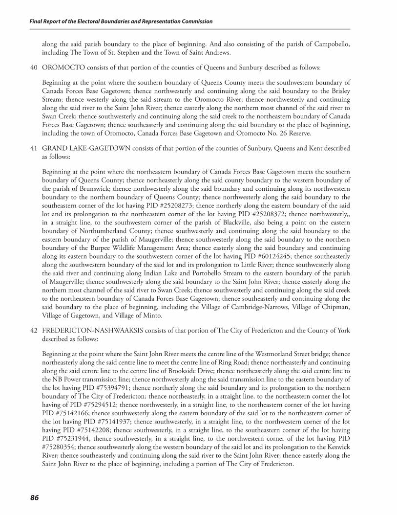
Final Report of the Electoral Boundaries and Representation Commission
86
along the said parish boundary to the place of beginning. And also consisting of the parish of Campobello, including The Town of St. Stephen and the Town of Saint Andrews.
40 OROMOCTO consists of that portion of the counties of Queens and Sunbury described as follows:
Beginning at the point where the southern boundary of Queens County meets the southwestern boundary of Canada Forces Base Gagetown; thence northwesterly and continuing along the said boundary to the Brisley Stream; thence westerly along the said stream to the Oromocto River; thence northwesterly and continuing along the said river to the Saint John River; thence easterly along the northern most channel of the said river to Swan Creek; thence southwesterly and continuing along the said creek to the northeastern boundary of Canada Forces Base Gagetown; thence southeasterly and continuing along the said boundary to the place of beginning, including the town of Oromocto, Canada Forces Base Gagetown and Oromocto No. 26 Reserve.
41 GRAND LAKE-GAGETOWN consists of that portion of the counties of Sunbury, Queens and Kent described as follows:
Beginning at the point where the northeastern boundary of Canada Forces Base Gagetown meets the southern boundary of Queens County; thence northeasterly along the said county boundary to the western boundary of the parish of Brunswick; thence northwesterly along the said boundary and continuing along its northwestern boundary to the northern boundary of Queens County; thence northwesterly along the said boundary to the southeastern corner of the lot having PID #25208273; thence northerly along the eastern boundary of the said lot and its prolongation to the northeastern corner of the lot having PID #25208372; thence northwesterly,, in a straight line, to the southwestern corner of the parish of Blackville, also being a point on the eastern boundary of Northumberland County; thence southwesterly and continuing along the said boundary to the eastern boundary of the parish of Maugerville; thence southwesterly along the said boundary to the northern boundary of the Burpee Wildlife Management Area; thence easterly along the said boundary and continuing along its eastern boundary to the southwestern corner of the lot having PID #60124245; thence southeasterly along the southwestern boundary of the said lot and its prolongation to Little River; thence southwesterly along the said river and continuing along Indian Lake and Portobello Stream to the eastern boundary of the parish of Maugerville; thence southwesterly along the said boundary to the Saint John River; thence easterly along the northern most channel of the said river to Swan Creek; thence southwesterly and continuing along the said creek to the northeastern boundary of Canada Forces Base Gagetown; thence southeasterly and continuing along the said boundary to the place of beginning, including the Village of Cambridge-Narrows, Village of Chipman, Village of Gagetown, and Village of Minto.
42 FREDERICTON-NASHWAAKSIS consists of that portion of The City of Fredericton and the County of York described as follows:
Beginning at the point where the Saint John River meets the centre line of the Westmorland Street bridge; thence northeasterly along the said centre line to meet the centre line of Ring Road; thence northeasterly and continuing along the said centre line to the centre line of Brookside Drive; thence northeasterly along the said centre line to the NB Power transmission line; thence northwesterly along the said transmission line to the eastern boundary of the lot having PID #75394791; thence northerly along the said boundary and its prolongation to the northern boundary of The City of Fredericton; thence northeasterly, in a straight line, to the northeastern corner the lot having of PID #75294512; thence northwesterly, in a straight line, to the northeastern corner of the lot having PID #75142166; thence southwesterly along the eastern boundary of the said lot to the northeastern corner of the lot having PID #75141937; thence southwesterly, in a straight line, to the northwestern corner of the lot having PID #75142208; thence southwesterly, in a straight line, to the southeastern corner of the lot having PID #75231944, thence southwesterly, in a straight line, to the northwestern corner of the lot having PID #75280354; thence southwesterly along the western boundary of the said lot and its prolongation to the Keswick River; thence southeasterly and continuing along the said river to the Saint John River; thence easterly along the Saint John River to the place of beginning, including a portion of The City of Fredericton.
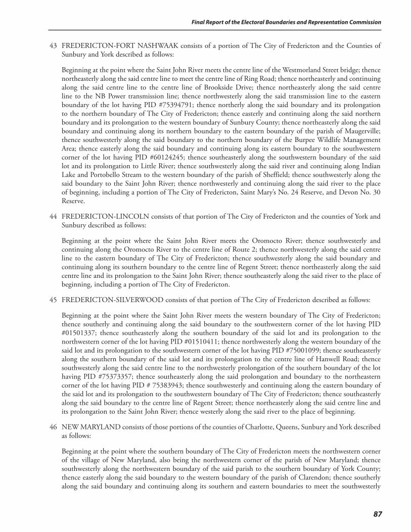
87
Final Report of the Electoral Boundaries and Representation Commission
43 FREDERICTON-FORT NASHWAAK consists of a portion of The City of Fredericton and the Counties of Sunbury and York described as follows:
Beginning at the point where the Saint John River meets the centre line of the Westmorland Street bridge; thence northeasterly along the said centre line to meet the centre line of Ring Road; thence northeasterly and continuing along the said centre line to the centre line of Brookside Drive; thence northeasterly along the said centre line to the NB Power transmission line; thence northwesterly along the said transmission line to the eastern boundary of the lot having PID #75394791; thence northerly along the said boundary and its prolongation to the northern boundary of The City of Fredericton; thence easterly and continuing along the said northern boundary and its prolongation to the western boundary of Sunbury County; thence northeasterly along the said boundary and continuing along its northern boundary to the eastern boundary of the parish of Maugerville; thence southwesterly along the said boundary to the northern boundary of the Burpee Wildlife Management Area; thence easterly along the said boundary and continuing along its eastern boundary to the southwestern corner of the lot having PID #60124245; thence southeasterly along the southwestern boundary of the said lot and its prolongation to Little River; thence southwesterly along the said river and continuing along Indian Lake and Portobello Stream to the western boundary of the parish of Sheffield; thence southwesterly along the said boundary to the Saint John River; thence northwesterly and continuing along the said river to the place of beginning, including a portion of The City of Fredericton, Saint Mary’s No. 24 Reserve, and Devon No. 30 Reserve.
44 FREDERICTON-LINCOLN consists of that portion of The City of Fredericton and the counties of York and Sunbury described as follows:
Beginning at the point where the Saint John River meets the Oromocto River; thence southwesterly and continuing along the Oromocto River to the centre line of Route 2; thence northwesterly along the said centre line to the eastern boundary of The City of Fredericton; thence southwesterly along the said boundary and continuing along its southern boundary to the centre line of Regent Street; thence northeasterly along the said centre line and its prolongation to the Saint John River; thence southeasterly along the said river to the place of beginning, including a portion of The City of Fredericton.
45 FREDERICTON-SILVERWOOD consists of that portion of The City of Fredericton described as follows:
Beginning at the point where the Saint John River meets the western boundary of The City of Fredericton; thence southerly and continuing along the said boundary to the southwestern corner of the lot having PID #01501337; thence southeasterly along the southern boundary of the said lot and its prolongation to the northwestern corner of the lot having PID #01510411; thence northwesterly along the western boundary of the said lot and its prolongation to the southwestern corner of the lot having PID #75001099; thence southeasterly along the southern boundary of the said lot and its prolongation to the centre line of Hanwell Road; thence southwesterly along the said centre line to the northwesterly prolongation of the southern boundary of the lot having PID #75373357; thence southeasterly along the said prolongation and boundary to the northeastern corner of the lot having PID # 75383943; thence southwesterly and continuing along the eastern boundary of the said lot and its prolongation to the southwestern boundary of The City of Fredericton; thence southeasterly along the said boundary to the centre line of Regent Street; thence northeasterly along the said centre line and its prolongation to the Saint John River; thence westerly along the said river to the place of beginning.
46 NEW MARYLAND consists of those portions of the counties of Charlotte, Queens, Sunbury and York described as follows:
Beginning at the point where the southern boundary of The City of Fredericton meets the northwestern corner of the village of New Maryland, also being the northwestern corner of the parish of New Maryland; thence southwesterly along the northwestern boundary of the said parish to the southern boundary of York County; thence easterly along the said boundary to the western boundary of the parish of Clarendon; thence southerly along the said boundary and continuing along its southern and eastern boundaries to meet the southwesterly
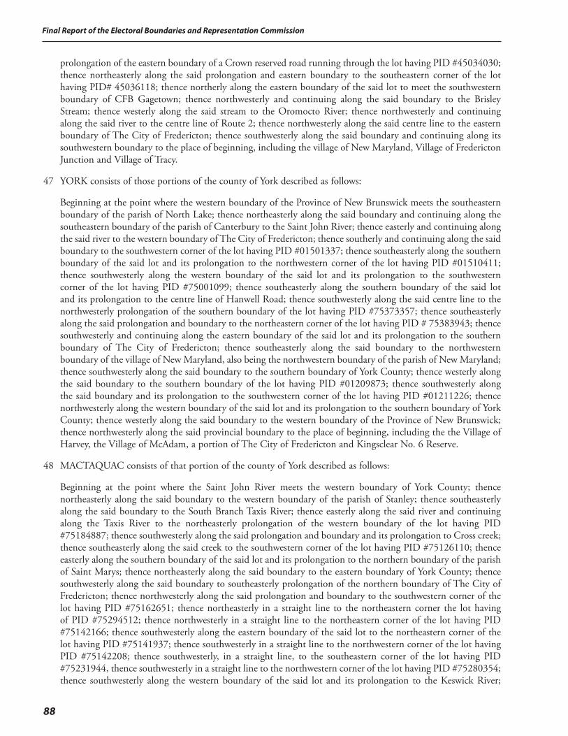
Final Report of the Electoral Boundaries and Representation Commission
88
prolongation of the eastern boundary of a Crown reserved road running through the lot having PID #45034030; thence northeasterly along the said prolongation and eastern boundary to the southeastern corner of the lot having PID# 45036118; thence northerly along the eastern boundary of the said lot to meet the southwestern boundary of CFB Gagetown; thence northwesterly and continuing along the said boundary to the Brisley Stream; thence westerly along the said stream to the Oromocto River; thence northwesterly and continuing along the said river to the centre line of Route 2; thence northwesterly along the said centre line to the eastern boundary of The City of Fredericton; thence southwesterly along the said boundary and continuing along its southwestern boundary to the place of beginning, including the village of New Maryland, Village of Fredericton Junction and Village of Tracy.
47 YORK consists of those portions of the county of York described as follows:
Beginning at the point where the western boundary of the Province of New Brunswick meets the southeastern boundary of the parish of North Lake; thence northeasterly along the said boundary and continuing along the southeastern boundary of the parish of Canterbury to the Saint John River; thence easterly and continuing along the said river to the western boundary of The City of Fredericton; thence southerly and continuing along the said boundary to the southwestern corner of the lot having PID #01501337; thence southeasterly along the southern boundary of the said lot and its prolongation to the northwestern corner of the lot having PID #01510411; thence southwesterly along the western boundary of the said lot and its prolongation to the southwestern corner of the lot having PID #75001099; thence southeasterly along the southern boundary of the said lot and its prolongation to the centre line of Hanwell Road; thence southwesterly along the said centre line to the northwesterly prolongation of the southern boundary of the lot having PID #75373357; thence southeasterly along the said prolongation and boundary to the northeastern corner of the lot having PID # 75383943; thence southwesterly and continuing along the eastern boundary of the said lot and its prolongation to the southern boundary of The City of Fredericton; thence southeasterly along the said boundary to the northwestern boundary of the village of New Maryland, also being the northwestern boundary of the parish of New Maryland; thence southwesterly along the said boundary to the southern boundary of York County; thence westerly along the said boundary to the southern boundary of the lot having PID #01209873; thence southwesterly along the said boundary and its prolongation to the southwestern corner of the lot having PID #01211226; thence northwesterly along the western boundary of the said lot and its prolongation to the southern boundary of York County; thence westerly along the said boundary to the western boundary of the Province of New Brunswick; thence northwesterly along the said provincial boundary to the place of beginning, including the the Village of Harvey, the Village of McAdam, a portion of The City of Fredericton and Kingsclear No. 6 Reserve.
48 MACTAQUAC consists of that portion of the county of York described as follows:
Beginning at the point where the Saint John River meets the western boundary of York County; thence northeasterly along the said boundary to the western boundary of the parish of Stanley; thence southeasterly along the said boundary to the South Branch Taxis River; thence easterly along the said river and continuing along the Taxis River to the northeasterly prolongation of the western boundary of the lot having PID #75184887; thence southwesterly along the said prolongation and boundary and its prolongation to Cross creek; thence southeasterly along the said creek to the southwestern corner of the lot having PID #75126110; thence easterly along the southern boundary of the said lot and its prolongation to the northern boundary of the parish of Saint Marys; thence northeasterly along the said boundary to the eastern boundary of York County; thence southwesterly along the said boundary to southeasterly prolongation of the northern boundary of The City of Fredericton; thence northwesterly along the said prolongation and boundary to the southwestern corner of the lot having PID #75162651; thence northeasterly in a straight line to the northeastern corner the lot having of PID #75294512; thence northwesterly in a straight line to the northeastern corner of the lot having PID #75142166; thence southwesterly along the eastern boundary of the said lot to the northeastern corner of the lot having PID #75141937; thence southwesterly in a straight line to the northwestern corner of the lot having PID #75142208; thence southwesterly, in a straight line, to the southeastern corner of the lot having PID #75231944, thence southwesterly in a straight line to the northwestern corner of the lot having PID #75280354; thence southwesterly along the western boundary of the said lot and its prolongation to the Keswick River;
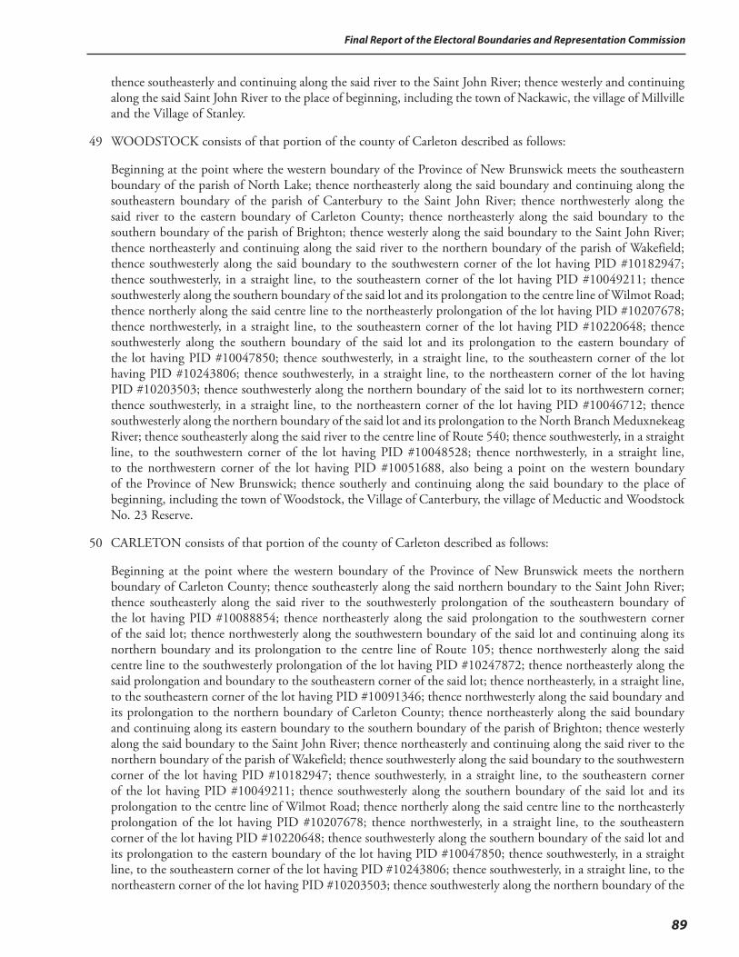
89
Final Report of the Electoral Boundaries and Representation Commission
thence southeasterly and continuing along the said river to the Saint John River; thence westerly and continuing along the said Saint John River to the place of beginning, including the town of Nackawic, the village of Millville and the Village of Stanley.
49 WOODSTOCK consists of that portion of the county of Carleton described as follows:
Beginning at the point where the western boundary of the Province of New Brunswick meets the southeastern boundary of the parish of North Lake; thence northeasterly along the said boundary and continuing along the southeastern boundary of the parish of Canterbury to the Saint John River; thence northwesterly along the said river to the eastern boundary of Carleton County; thence northeasterly along the said boundary to the southern boundary of the parish of Brighton; thence westerly along the said boundary to the Saint John River; thence northeasterly and continuing along the said river to the northern boundary of the parish of Wakefield; thence southwesterly along the said boundary to the southwestern corner of the lot having PID #10182947; thence southwesterly, in a straight line, to the southeastern corner of the lot having PID #10049211; thence southwesterly along the southern boundary of the said lot and its prolongation to the centre line of Wilmot Road; thence northerly along the said centre line to the northeasterly prolongation of the lot having PID #10207678; thence northwesterly, in a straight line, to the southeastern corner of the lot having PID #10220648; thence southwesterly along the southern boundary of the said lot and its prolongation to the eastern boundary of the lot having PID #10047850; thence southwesterly, in a straight line, to the southeastern corner of the lot having PID #10243806; thence southwesterly, in a straight line, to the northeastern corner of the lot having PID #10203503; thence southwesterly along the northern boundary of the said lot to its northwestern corner; thence southwesterly, in a straight line, to the northeastern corner of the lot having PID #10046712; thence southwesterly along the northern boundary of the said lot and its prolongation to the North Branch Meduxnekeag River; thence southeasterly along the said river to the centre line of Route 540; thence southwesterly, in a straight line, to the southwestern corner of the lot having PID #10048528; thence northwesterly, in a straight line, to the northwestern corner of the lot having PID #10051688, also being a point on the western boundary of the Province of New Brunswick; thence southerly and continuing along the said boundary to the place of beginning, including the town of Woodstock, the Village of Canterbury, the village of Meductic and Woodstock No. 23 Reserve.
50 CARLETON consists of that portion of the county of Carleton described as follows:
Beginning at the point where the western boundary of the Province of New Brunswick meets the northern boundary of Carleton County; thence southeasterly along the said northern boundary to the Saint John River; thence southeasterly along the said river to the southwesterly prolongation of the southeastern boundary of the lot having PID #10088854; thence northeasterly along the said prolongation to the southwestern corner of the said lot; thence northwesterly along the southwestern boundary of the said lot and continuing along its northern boundary and its prolongation to the centre line of Route 105; thence northwesterly along the said centre line to the southwesterly prolongation of the lot having PID #10247872; thence northeasterly along the said prolongation and boundary to the southeastern corner of the said lot; thence northeasterly, in a straight line, to the southeastern corner of the lot having PID #10091346; thence northwesterly along the said boundary and its prolongation to the northern boundary of Carleton County; thence northeasterly along the said boundary and continuing along its eastern boundary to the southern boundary of the parish of Brighton; thence westerly along the said boundary to the Saint John River; thence northeasterly and continuing along the said river to the northern boundary of the parish of Wakefield; thence southwesterly along the said boundary to the southwestern corner of the lot having PID #10182947; thence southwesterly, in a straight line, to the southeastern corner of the lot having PID #10049211; thence southwesterly along the southern boundary of the said lot and its prolongation to the centre line of Wilmot Road; thence northerly along the said centre line to the northeasterly prolongation of the lot having PID #10207678; thence northwesterly, in a straight line, to the southeastern corner of the lot having PID #10220648; thence southwesterly along the southern boundary of the said lot and its prolongation to the eastern boundary of the lot having PID #10047850; thence southwesterly, in a straight line, to the southeastern corner of the lot having PID #10243806; thence southwesterly, in a straight line, to the northeastern corner of the lot having PID #10203503; thence southwesterly along the northern boundary of the
Final Report of the Electoral Boundaries and Representation Commission
90
said lot to its northwestern corner; thence southwesterly, in a straight line, to the northeastern corner of the lot having PID #10046712; thence southwesterly along the northern boundary of the said lot and its prolongation to the North Branch Meduxnekeag River; thence southeasterly along the said river to the centre line of Route 540; thence southwesterly, in a straight line, to the southwestern corner of the lot having PID #10048528; thence northwesterly, in a straight line, to the northwestern corner of the lot having PID #10051688, also being a point on the western boundary of the Province of New Brunswick; thence northerly along the said boundary to the place of beginning, including the Town of Hartland, the Village of Bath, the villages of Bristol, Centreville and Florenceville.
51 VICTORIA-TOBIQUE consists of those portions of the counties of Victoria and Carleton described as follows:
Beginning at the point where the western boundary of the Province of New Brunswick meets the northern boundary of Carleton County; thence southeasterly along the said northern boundary to the Saint John River; thence southeasterly along the said river to the southwesterly prolongation of the southeastern boundary of the lot having PID #10088854; thence northeasterly along the said prolongation to the southwestern corner of the said lot; thence northwesterly along the southwestern boundary of the said lot and continuing along its northern boundary and its prolongation to the centre line of Route 105; thence northwesterly along the said centre line to the southwesterly prolongation of the lot having PID #10247872; thence northeasterly along the said prolongation and boundary to the southeastern corner of the said lot; thence northeasterly, in a straight line, to the southeastern corner of the lot having PID #10091346; thence northwesterly along the said boundary and its prolongation to the southern boundary of Victoria County; thence northeasterly along the said boundary and continuing along its eastern and northern boundary to the eastern boundary of the parish of Drummond; thence southwesterly along the said boundary to the Salmon River; thence southwesterly along the said river to the Saint John River; thence southwesterly along the said river to meet the northeasterly prolongation of the southern boundary of the lot having PID#65088114; thence southwesterly along the said prolongation and boundary to the south eastern corner of the lot having PID# 65084253; thence along the southern boundary of said lot and its prolongation to the centre line of Route 1; thence northerly along the said centre line to meet the easterly prolongation of the southern boundary of the lot having PID #65085433; thence westerly along the said prolongation and boundary and its prolongation to Little River; thence northerly along the said river to the southern limits of Route 375; thence westerly along the said limits to the centre line of Back California Settlement Road; thence southerly along the said centre line to meet the easterly prolongation of the southern boundary of the lot having PID #65155178; thence westerly along the said prolongation and boundary to the northwestern corner of the lot having PID #65089021; thence along the western boundary of the said lot to a point 150m south of the southern limits of Route 375; thence westerly, maintaining a distance of 150m from the said limits to the western boundary of the province of New Brunswick; thence southerly along the said boundary to the place of beginning, including Village of Aroostook, Village of Perth-Andover, village of Plaster Rock and Tobique No. 20 Reserve.
52 GRAND FALLS-DRUMMOND-SAINT-ANDRÉ consists of that portion of the counties of Madawaska and Victoria described as follows:
Beginning at the point where the western boundary of the Province of New Brunswick meets the southwesterly prolongation of the southeastern boundary of the lot having PID #35256148; thence northeasterly along the said prolongation and boundary to the centre line of Route 2; thence northwesterly along the said centre line to the southwesterly prolongation of the southeastern boundary of the lot having PID #35101047; thence northeasterly along the said prolongation and boundary to the southwestern limits of a Crown reserved road; thence northwesterly along the said limits to a point being 500m south of the southern limits of Route 17; thence northeasterly, maintaining a distance of 500m from the said limits, to the northern boundary of the parish of St. André; thence northeasterly along the said boundary and its prolongation to the eastern boundary of the parish of Drummond; thence southwesterly along the said boundary to the Salmon River; thence southwesterly along the said river to the Saint John River; thence southwesterly along the said river to meet the northeasterly prolongation of the southern boundary of the lot having PID#65088114; thence southwesterly along the said
91
Final Report of the Electoral Boundaries and Representation Commission
prolongation and boundary to the south eastern corner of the lot having PID# 65084253; thence along the southern boundary of said lot and its prolongation to the centre line of Route 1; thence northerly along the said centre line to meet the easterly prolongation of the southern boundary of the lot having PID #65085433; thence westerly along the said prolongation and boundary and its prolongation to Little River; thence northerly along the said river to the southern limits of Route 375; thence westerly along the said limits to the centre line of Back California Settlement rd; thence southerly along the said centre line to meet the easterly prolongation of the southern boundary of the lot having PID #65155178; thence westerly along the said prolongation and boundary to the northwestern corner of the lot having PID #65089021; thence along the western boundary of the said lot to a point 150m south of the southern limits of Route 375; thence westerly, maintaining a distance of 150m from the said limits to the western boundary of the province of New Brunswick; thence northerly and continuing along the said boundary to the place of beginning, including The Town of Grand Falls-La Ville de Grand-Sault, Village of Drummond and Village de St. André.
53 RESTIGOUCHE-LA-VALLÉE consists of those portions of the counties of Madawaska, Victoria and Restigouche described as follows:
Beginning at the point where the western boundary of the province of New Brunswick meets the county line between the counties of Madawaska and Restigouche; thence southeasterly along the northern boundary of Madawaska County to the western boundary of the parish of Riviere-Verte; thence southwesterly and continuing along the said boundary to the northeastern boundary of the City of Edmundston; thence southeasterly and continuing along the said boundary to the western boundary of the Province of New Brunswick; thence southeasterly and continuing along the said boundary to the southwesterly prolongation of the southeastern boundary of the lot having PID #35256148; thence northeasterly along the said prolongation and boundary to the centre line of Route 2; thence northwesterly along the said centre line to the southwesterly prolongation of the southeastern boundary of the lot having PID #35101047; thence northeasterly along the said prolongation and boundary to the southwestern limits of a Crown reserved road; thence northwesterly along the said limits to a point being 500m south of the southern limits of Route 17; thence northeasterly, maintaining a distance of 500m from the said limits, to the northern boundary of the parish of Saint-André; thence northeasterly along the said boundary and its prolongation to the western boundary of the parish of Denmark; thence northeasterly along the said boundary to the northern boundary of Victoria County; thence southeasterly along the said boundary to the westerly prolongation of the southern boundary of the lot having PID #40217523; thence easterly along the said prolongation and boundary to the southerly prolongation of the eastern boundary of the parish of Addington; thence northerly along the said prolongation and boundary to the southern boundary of the lot having PID #50184084; thence westerly along the said boundary and its prolongation to the northwestern corner of the lot having PID #50194620; thence northwesterly, in a straight line, to the southeastern corner of the lot having PID #50346311; thence northwesterly along the eastern boundary of the said lot and its prolongation to the northern boundary of the Province of New Brunswick; thence westerly along the said boundary to the place of beginning, including the Town of St. Leonard, the town of Saint-Quentin, the Village of Kedgwick, the Village of Rivière-Verte and the Village of Sainte-Anne-de-Madawaska.
54 EDMUNDSTON-SAINT-BASILE consists of that portion of the city of Edmundston described as follows:
Beginning at the point where the eastern boundary of the City of Edmundston meets the Saint John River; thence northeasterly along the said boundary and continuing along its northern boundary to the southwestern banks or shores of the Madawaska River, also being a point on the parish line between the parishes of Saint-Jacques and Madawaska; thence northwesterly and continuing along the said parish line to the northwesterly prolongation of the southwestern boundary of the lot having PID #35165703; thence southeasterly along the said prolongation and boundary and continuing along its southeastern boundary to the northwesterly prolongation of the eastern boundary of the lot having PID #35149848; thence southeasterly along the said prolongation and boundary to the northeastern corner of the lot having PID #35148071; thence southeasterly along the eastern boundary of the said lot and its prolongation to the Saint John River; thence northeasterly and continuing along the said river to the place of beginning, including a portion of the City of Edmundston and the St. Basile No. 10 Reserve.
92
Final Report of the Electoral Boundaries and Representation Commission
55 MADAWASKA-LES-LACS consists of that portion of the county of Madawaska and the City of Edmundston described as follows:
Beginning at the point where the western boundary of the Province of New Brunswick meets the boundary between the counties of Restigouche and Madawaska; thence southeasterly along the northern boundary of Madawaska County to the western boundary of the parish of Rivière-Verte; thence southwesterly and continuing along the said boundary to the northern boundary of the City of Edmundston; thence northwesterly and continuing along the said boundary to the southwestern banks or shores of the Madawaska River, also being a point on the parish line between the parishes of Saint-Jacques and Madawaska; thence northwesterly and continuing along the said parish line to the northwesterly prolongation of the southwestern boundary of the lot having PID #35165703; thence southeasterly along the said prolongation and boundary and continuing along its southeastern boundary to the northwesterly prolongation of the eastern boundary of the lot having PID #35149848; thence southeasterly along the said prolongation and boundary to the northeastern corner of the lot having PID #35148071; thence southeasterly along the eastern boundary of the said lot and its prolongation to the Saint John River; thence southwesterly and continuing along the said river to the northern boundary of the Province of New Brunswick; thence northeasterly and continuing along the said boundary to the place of beginning, including a portion of the City of Edmundston, the village of Baker Brook, the Village of Clair, the Village of Lac Baker, the Village of Saint-François de Madawaska and the Village de St. Hilaire.
Note: The legal descriptions of the boundaries of the electoral districts were drafted by the staff of the Office of the Chief Electoral Officer at the request of the Commission.