3. HISTORY OF BLOOMSBURY
14
32 3. HISTORY OF BLOOMSBURY Slick land dealings, poor drainage, and long-term interpersonal relationships shaped the families that inhabited, improved, and cultivated a poor patch of clay soils. The subject property is part of the 300- acre Bloomsbury tract, surveyed in 1683 for William Williams (Figure 8). The beginning point of the survey was described as a large sweet gum at the head of Hirons’ Branch, which later became a point of bitter contention. William’s son, Thomas, had moved away by the time his father died in 1735. He appointed James Morris as his attorney to sell the farm. The buyer was Samuel Exell (or Axell), stepson of a Smyrna tavernkeeper. Exell owned some land that his mother had left him, but he sold it when he bought the farm. He obtained a new warrant and had it resurveyed and repatented, gaining a fresh title to Bloomsbury thereby. According to local gossip repeated in a 1785 deposition of John Drayton, surveyor George Stevenson told him that Axell had ordered the surveyor to interpret the property description to include better ground farther down the branch, which actually was part of Hillyard’s Adventure. This move caused a gap of “unclaimed” land between the adjacent Bloomsbury and Barren Hope tracts. The surveyor laid claim to the vacancy and obtained a proprietary warrant, which he sold to William Sappington on an unknown date. A few years later, in 1746, Exell sold the northern hundred acres to Edward Joy. At that time, Timothy Eads had a house near the southwest corner of the Bloomsbury tract, but the deed is silent upon which property it occupied. The starting point near the Eads house is the corner of Route 6 and the property’s west line. Exell died without a will in 1753, owning little more than the surviving part of Bloomsbury, most of which remained forested (Figure 9). His widow, two sons, and two daughters lived at the east side of the property, next to a large and valuable farm called Hillyard’s Adventure. The estate also owned a marsh at the mouth of Hirons Branch surveyed in 1745 for Exell. The heirs sold it for £10 to Dr, Charles Ridgely, owner of Hillyard’s Adventure, in 1771, after the children reached their majority. The eldest son died unmarried, without issue, before achieving his majority, which meant that the three surviving children shared in the estate, with a lifetime dower of a third set aside for the widow. Around 1770, the Pearsons were Sarah BLOOMSBURY OWNERSHIP AND TENANCY, 1770 -1812 1770-1780 1780-1790 1790-1800 1800-1810 West owner: Axell Estate Mary James McMullen Martha McMullen Francis Denney Allee Project area tenant: Pearson Thomas Cutler John Sisco T. Consealor Center owner: Axell Estate Prudence Macey and then her heirs Francis Denney Allee tenant: Pearson Patrick Conner John Sisco T. Consealor East owner: Axell Estate Samuel Axell II J.Allee Heirs of John Allee [Abraham Allee] tenant: Pearson Patrick Conner --------First well ? --Second well--
Transcript of 3. HISTORY OF BLOOMSBURY

32
3. HISTORY OF BLOOMSBURY
Slick land dealings, poor drainage, and long-term interpersonalrelationships shaped the families that inhabited, improved, and
cultivated a poor patch of clay soils.The subject property is part of the 300-
acre Bloomsbury tract, surveyed in 1683 forWilliam Williams (Figure 8). The beginningpoint of the survey was described as a largesweet gum at the head of Hirons’ Branch,which later became a point of bitter contention.
William’s son, Thomas, had movedaway by the time his father died in 1735. Heappointed James Morris as his attorney to sellthe farm.
The buyer was Samuel Exell (orAxell), stepson of a Smyrna tavernkeeper.Exell owned some land that his mother had lefthim, but he sold it when he bought the farm.He obtained a new warrant and had itresurveyed and repatented, gaining a fresh titleto Bloomsbury thereby.
According to local gossip repeated in a1785 deposition of John Drayton, surveyorGeorge Stevenson told him that Axell hadordered the surveyor to interpret the propertydescription to include better ground fartherdown the branch, which actually was part ofHillyard’s Adventure. This move caused a gapof “unclaimed” land between the adjacentBloomsbury and Barren Hope tracts. Thesurveyor laid claim to the vacancy and
obtained a proprietary warrant, which he sold toWilliam Sappington on an unknown date.
A few years later, in 1746, Exell soldthe northern hundred acres to Edward Joy. Atthat time, Timothy Eads had a house near thesouthwest corner of the Bloomsbury tract, butthe deed is silent upon which property itoccupied. The starting point near the Eads houseis the corner of Route 6 and the property’s westline.
Exell died without a will in 1753, owning littlemore than the surviving part of Bloomsbury,most of which remained forested (Figure 9). Hiswidow, two sons, and two daughters lived at theeast side of the property, next to a large andvaluable farm called Hillyard’s Adventure. Theestate also owned a marsh at the mouth ofHirons Branch surveyed in 1745 for Exell. Theheirs sold it for £10 to Dr, Charles Ridgely,owner of Hillyard’s Adventure, in 1771, afterthe children reached their majority.
The eldest son died unmarried, withoutissue, before achieving his majority, whichmeant that the three surviving children shared inthe estate, with a lifetime dower of a third setaside for the widow.
Around 1770, the Pearsons were Sarah
BLOOMSBURY OWNERSHIP AND TENANCY, 1770 -18121770-1780 1780-1790 1790-1800 1800-1810
West owner: Axell Estate Mary James McMullen Martha McMullen Francis DenneyAlleeProject area tenant: Pearson Thomas Cutler John Sisco T. Consealor
Center owner: Axell Estate Prudence Macey and then her heirs Francis DenneyAllee
tenant: Pearson Patrick Conner John Sisco T. Consealor
East owner: Axell Estate Samuel Axell II J.Allee Heirs of John Allee [Abraham Allee]tenant: Pearson Patrick Conner
--------First well ? --Second well--
33
Exell’s tenants on Bloomsbury. According tothe 1795 testimony of James Pearson, hisfather’s house stood about 25 yards eastwardfrom a marked oak along the western propertyline.
LAND GRAB SPAWNS DISPUTE
Immediately to the west was theBarren Hope tract owned by the Allee family.When Axell “relocated” his tract’s boundariesdownstream , the survey created a bogusvacancy between Bloomsbury and BarrenHope. In June 1746, the surveyor, GeorgeStevenson, laid claim to the 105 acres“between” the adjacent Barren Hope andBloomsbury tracts (Kent County Warrant book,p. 195; Kent County Surveys S5#2). Heobtained a warrant, which he sold to WilliamSappington.
Many years later, Daniel Morris statedthat the Sappington family house was within ahundred yards of the corner gum at the head ofHirons Branch. He recalled an old dwellinghouse on the Bloomsbury tract near its westerncorner, roughly the location of the spot we nowknow as the Hurd site.
Sappington cut timber off the property
gathered together, and Mrs. Axell was describedas being in “violent passion” over the line.
Abraham Allee, who then owned theHillyard’s Adventure property, knew that thewidow Axell was in fact living on his land, andwould not raise the issue while his elderlykinswoman lived there.
In 1784, when a later owner ofHillyard’s Adventure tried to unravel the disputeover the lines,James Morris gave testimony thatthe actual line between Bloomsbury andHillyard’s Adventure ran through Mrs. Axell’sbarn and that her house actually stood onHillyard’s Adventure (Kent County ChanceryR#3).
The widow Axell’s son-in-law, JohnMacFarland, took the roof off Sappington’shouse after his death, in an attempt to evictAgness. The widow tried to stay in the rooflesshouse for a few days. When it became obviousthat Mrs. Sappington would not leave, Mary(Polly) Axell MacFarland paid a settlement toget her off the property. Mrs. Sappington thenmoved across the creek and lived in Thompson'sloft.
According to a petition Agness filedwith the Orphans Court, the payment was
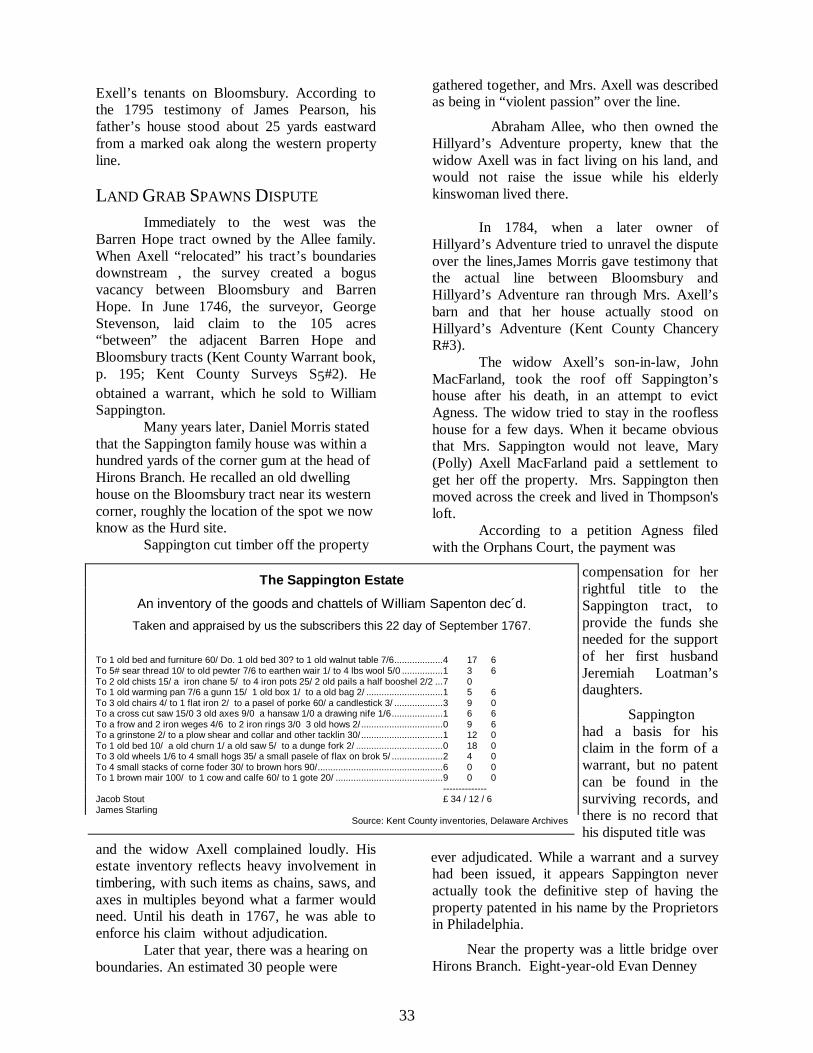
The Sappington Estate
An inventory of the goods and chattels of William Sapenton dec´d.
Taken and appraised by us the subscribers this 22 day of September 1767.
To 1 old bed and furniture 60/ Do. 1 old bed 30? to 1 old walnut table 7/6...................4 17 6To 5# sear thread 10/ to old pewter 7/6 to earthen wair 1/ to 4 lbs wool 5/0 ................1 3 6To 2 old chists 15/ a iron chane 5/ to 4 iron pots 25/ 2 old pails a half booshel 2/2 ...7 0To 1 old warming pan 7/6 a gunn 15/ 1 old box 1/ to a old bag 2/ ..............................1 5 6To 3 old chairs 4/ to 1 flat iron 2/ to a pasel of porke 60/ a candlestick 3/ ...................3 9 0To a cross cut saw 15/0 3 old axes 9/0 a hansaw 1/0 a drawing nife 1/6....................1 6 6To a frow and 2 iron weges 4/6 to 2 iron rings 3/0 3 old hows 2/................................0 9 6To a grinstone 2/ to a plow shear and collar and other tacklin 30/................................1 12 0To 1 old bed 10/ a old churn 1/ a old saw 5/ to a dunge fork 2/ ..................................0 18 0To 3 old wheels 1/6 to 4 small hogs 35/ a small pasele of flax on brok 5/ ....................2 4 0To 4 small stacks of corne foder 30/ to brown hors 90/.................................................6 0 0To 1 brown mair 100/ to 1 cow and calfe 60/ to 1 gote 20/ ..........................................9 0 0
--------------Jacob Stout £ 34 / 12 / 6James Starling
Source: Kent County inventories, Delaware Archives
compensation for herrightful title to theSappington tract, toprovide the funds sheneeded for the supportof her first husbandJeremiah Loatman’sdaughters.
Sappingtonhad a basis for hisclaim in the form of awarrant, but no patentcan be found in thesurviving records, andthere is no record thathis disputed title was
and the widow Axell complained loudly. Hisestate inventory reflects heavy involvement intimbering, with such items as chains, saws, andaxes in multiples beyond what a farmer wouldneed. Until his death in 1767, he was able toenforce his claim without adjudication.
Later that year, there was a hearing onboundaries. An estimated 30 people were
ever adjudicated. While a warrant and a surveyhad been issued, it appears Sappington neveractually took the definitive step of having theproperty patented in his name by the Proprietorsin Philadelphia.
Near the property was a little bridge overHirons Branch. Eight-year-old Evan Denney

34
was helping his father and two uncles drivecattle across the branch, about 1765.
He recalled in a 1795 deposition thathis father boxed his ears when he misbehavedduring that cattle drive, and his uncleChristopher laughed and said “give him awhipping so he will remember Axell’s corner.”Sure enough, Evan Denney still rememberedthe corner thirty years later.
DIVIDING BLOOMSBURY
Both Exell daughters had been marriedand widowed before their father’s land couldbe divided.
Prudence Macey (or Massey), daughter ofSamuel Exell, petitioned the court forallocation of her third in November 1770. Sheand her second husband pointed out that allthree surviving children had attained legal age.When the division was completed May 7, 1771,Prudence received the middle third.
In order to allocate the farm, a surveywas prepared by Mark McCall and submitted toOrphans Court (Figure 9). The outline ofcleared land is well defined on the map, but nohouse is indicated. While making the survey,McCall found that the corner gum tree at thehead of Hirons Branch had rotted away. So hemarked a young white oak nearby with twelvenotches to re-mark the corner. This seeminglyinnocent act would be the cause for a Chancerycase 25 years later, when a later owner tried toestablish her lines on the location of the gumstump.
Since the smallest acreage went to sonSamuel, it is likely that the family home at thattime was on the eastern third, outside thecurrent DelDOT property boundaries. As eldestsurviving son, Samuel the younger would havebeen entitled to a double share, which meansthat his small acreage contained some elementof greater value, in addition to the fact that itcontained most of the cleared land.
According to the 1795 deposition ofJames Morris, the Axell residence was near theHillyard’s Adventure line, the east boundary ofthe tract.
MARY’S THIRD OF BLOOMSBURY
The widowed owner of western third ofBloomsbury, Mary (Polly) Griffin, soonremarried Patrick (Paddy) Conner, who was heirto a farm north of the project area, on the southbank of Duck Creek. Mary’s third, containing74 acres 136 perches, was the largest of thethree, which is commonly interpreted to meanthat it was the least desirable. In fact it containstwo undrained swamps today. It was her onlydowry, since her first husband’s tiny estate hadbeen administered by one of his creditors tosatisfy his debts.
The Conners and widow Exel conveyedtheir interests in 1772 to James McMullen, aSmyrna merchant. He died in 1784, leaving histhird of Bloomsbury to his minor daughterMartha.
At the February court term in 1795,Martha’s guardian, Eleazer McComb, asked theChancellor to send commissioners to takedepositions on the boundaries of Bloomsbury,and particularly the western third. In thepetition, it was alleged that the boundaries had“decayed.” The commissioners, Joseph Nock,Alan McLane, and George Cummins, weresworn in September 16.
Patrick Conner, who apparently was stillmanaging parts of the property, served legalpapers on the neighbors. He was disputing theboundary with Edward Joy, the neighbor whoowned the inland end of Bloomsbury.Commissioners gathered the neighbors todiscuss the boundaries, and many stories weretold, some under oath. The resulting depositionshave survived to shed some light on the localscene at the time.
According to testimony, a house wasbuilt for McMullen’s tenant, Thomas Cutler,around 1775. Joseph Thompson, whose familyowned land across the branch, deposed in 1795that John VanGaskin the younger showed him acorner tree of Bloomsbury while the Cutlerhouse was being built. This was the same oak atthe present southwest corner of the projectproperty that McCall had marked to replace theold gum stump corner tree a few years earlier.

35
Curiously enough, Thomas Cutler did not givetestimony, even though he was the one personmost likely to have practical knowledge of theproperty’s actual boundaries. Nor did McCalltestify.
Cutler is listed in the 1782 state censusand assessment with two adults and fourpeople in his household below the age of 18.His assessment was in the lowest category(Nelson, Nelson, Doherty, Richards andRichards 1994).
In 1801 Martha McMullen sold thewestern third to Francis Denney. ThomasCutler still was the sitting tenant, even thoughhe was not reported as living in the neck on the1800 United States census (pages 81-82).
remnant. The two western thirds, as listed in theearlier survey, totalled 139 acres 136 perches.No improvements of any value were listed onthe property assessment.
Francis Denney died in 1812, andordered his estate to be divided among his threesons and two daughters, one of whom wasSusannah Allee, wife of Abraham. SarahDenney in November 1812 renounced her rightto a dower interest in her children’s farms (KentCounty Deed Book O-2:21), which allowedthem to take full possession during her lifetime.
When the Denney estate was divided,surveyor Archibald McCall found that itcontained 140 acres, 19 perches, “whereonThomas Conseilor now lives.” Unfortunately,
THE MIDDLETHIRD
John Maceydied in 1796, andPrudence apparentlysoon after. Prudenceleft three heirs: MaryHart (daughter of herearlier marriage to JohnMacFarland), John, andJonathan. At somepoint, Mary sold herprospective interest toher uncle Patrick
All the goods and chattelsAn inventory of all the goods and chattels of Samuel AxelDecd of Duck Creek Hundred in the County of Kent in theDelaware State as appraised by us the subscribers the 5thof December 1783 –
To his wearing apparel £1/5/0To 1 Bed bedstead and furniture 4/0/0To 1 Chest and some old stuff therein 7/6 7/6To 1 small box 3/9 pewter 16/ 19/9To some old ware with meal sifter 3/6 3/6To 1 small table 6 2 iron pots 22/6 1/3/0To 1 small pewter basin 2/ some old things 2/ 4/0To 1 bay mare £6 6/0/0
----------£14/2/9
Source: Kent County Inventories, Delaware Archives
the draft survey(Figure 11), now in thepossession of GeorgeH. Jones, esq., doesnot show a house onthe property, eventhough it clearly statesthat Conseilor wasliving there, notmerely a tenant inpossession who livedelsewhere, as PatrickConner had been.
Five acres, the
Conner, who asked Orphans Court to sendcommissioners to make a division of the Maceythird. The division never took place. John andJonathan may have been Macey’s sons by anearlier marriage. There must have beensubstance to the claim, for the administrator ofJohn Macey’s estate paid rent to Conner.
After the litigation ended, the Maceytract was sold by the sheriff in 1799 to satisfycreditors of John and Jonathan Macey. Thepurchaser was Francis Denney.
John Sisco was listed in the 1803-1804reassessment as Denney’s tenant on aplantation of 134.5 acres, which is almostexactly two-thirds of the 202 acres measured inthe 1771 Axel survey of the Bloomsbury
northwest tip of the western third, was allocatedto Francis Denney Jr., and continues today to becited as a separate tract in the deeds to theproperty (Figures 11-12).
SAMUEL’S THIRD
Samuel Exell, the younger, died in 1783,leaving an estate valued at only £14 / 2 / 9.
His will, proved August 20, 1783, left hismovable estate and his money to his niece MaryHart, daughter of Prudence. His real estate wasleft to his “cousin and only friend John Allee,”who was actually the husband of his cousin’swife’s sister, Rachel Moore, daughter of Johnand Henrietta Moore. This is within thetraditional range of Kent County cousinship.

36
Plate 6Aerial view of the Abraham Allee farmstead
from the south, as it appears todaywithout most of its buildings
included more profitableproperties. Francis Denneyowned nine plantations in Kentand New Castle counties to bedivided among his five children,with each son to receive a shareworth £100 more than eachdaughter’s share. ThomasConsealor would not remain longas Allee’s tenant.
Storekeeper BenjaminCoombe went to the Justice ofthe Peace in February 1814 tocollect Consealor’s bill. This wasonly the beginning of the year’stroubles.
Axell’s former property was then tilledby his brother-in-law Patrick Conner, whocultivated only 35 acres. The Allee estatevaluation of 1791 described the house as “alogged dwelling house about eighteen feetsquare,” into which the Orphans Courtcommissioners ordered a brick chimney to bebuilt. There was also a roofless uncompletedlog kitchen.
Conner laid claim to a 200-acre tract hecalled “Canton,” that he alleged was vacantland between Bloomsbury and Hillyard’sAdventure to the east (Figure 10). A warrantwas issued by Recorder Simon Wilmer Wilsonin December 1794, and Edward Joy filed acaveat against it. Conner’s claim of thevacancy would start a legal battle with thewealthy Joy family. The next year Chancerycommissioners came to the site to settle theboundary of Bloomsbury.
In the 1803-1804 reassessment book,Patrick Conner, Sr., was listed as owning asmall plantation containing 62 acres valued at$10 per acre, with three head of horses. He wasstill listed as tenanting the Axell third of theland in the 1803-1804 assessment.
Abraham Allee married SusannahDenney on February 19, 1805. They had sixchildren, of whom three survived infancy.Abraham Allee inherited the western two-thirdsof Bloomsbury in right of his wife when hisfather-in-law died in 1812. Bloomsbury wasnot exactly a profit center. Fortunately for theyoung couple, their combined inheritances
Abraham Allee tried to evict Consealoron April 16, when he entered the “close”(fenced field) and took hold of Consealor’s plowhorses and ordered him off the farm. Jacob andMoses Thompson then entered the close andplowed the field for themselves. Consealor wentto Justice of the Peace James Schee in Dover onApril 18 and filed suit against all three. Theyposted bond on April 20, and the case wasreferred to Common Pleas. On September 1,Moses Thompson entered the close and threwdown ten panels of fences before he plowed theground. Consealor sued again. After repeatedcontinuances, the case disappeared, unresolved,from the Common Pleas docket after theDecember term 1817.
In the 1815 assessment, John Allee’s heirs[actually Abraham] were credited with 83 acres,all cleared, called the Axle land. This is 21acres more than the 1771 division mapdescribed for the east third, but acreageestimates tended to be fluid. By now, Abrahamand his bride were in actual possession of thewhole Bloomsbury estate and ThomasConsealor apparently had moved to New Jersey.
A survey of Barren Hope dated 1821 describesthe property as “An ancient tract of land calledBloomsbury formerly of Samuel Exels heirs,now belongs to Abraham Allee in right of hiswife Susannah, one of the daughters of FrancisDenney, deceased, allotted and assigned underand by virtue of Orphans Court.” The courtrecord is absent, even though there are severalreferences to it, and a draft survey exists.

37
Original survey ofBloomsbury
Copied from the original1686 syrvey, DelawareArchives, Kent County
Warrants and Surveys W5#27
Laid out for WilliamWilliams
|--------|660 feet
Figure 8
Bloomsbury in 1863, as surveyed for William Williams

38
Division of
Bloomsbury1770
Samuel Axell estate fileKent County Orphans Court
Delaware Archives
Record Group 3840
Figure 9Bloomsbury in 1770, as divided for Orphans Court by McCall

39
Figure 10
A redraft of the plot for Patrick Conner’s claim to the Canton patent, madeat the time he was farming the eastern third of the Bloomsbury property.

40
Solid lines outline the property left by Francis Denney. Ground cover is from the ArchibaldMcCall survey, September 1-2, 1812. Described as "whereon Thomas Counseilor now lives."
Figure 11
Bloomsbury in 1812, as divided for Orphans Court(Based upon a draft loaned by George H. Jones, esq.)

41
Figure 12
The Fords divide Bloomsbury into the two parts that continue today

42
Plate 7
1937 ærial photograph of the project area, same scale as maps.

43
The 1852-1853 reassessment showsAbraham Allee owning a tract of 170 acres,145 improved, with a log house, and anothertract of 120 acres, 90 improved, with a loghouse. A house was on the Bloomsburyproperty in 1859, roughly where the presentdwelling stands (Fig 13).
When he died in 1858, he left the tractto his daughter Sallie (Sarah, wife of WilliamSavin) and his sons James and Jonathan. Theproperty was identified in the will as “60 acres”on Pumpkin Neck adjoining AlexanderPeterson, Daniel Cummins, John M. Voshell,and others. These people were adjoiners of thewhole tract, whose properties would not haveadjoined any one of the third parts. Therefore,Abraham must have been referring to the entireBloomsbury tract, of which he owned one thirdin his own right
present house was built late in the Alleetenure, possibly as late as 1858. The house isoriented toward the road, laid out in 1824(Scharf 1888:1096). Earlier houses on theproperty would have been oriented towardDutch Neck Road, with access to Dutch NeckRoad by the small Hirons Branch bridge andthen by a road through Thompson’s farm on theWestmoreland tract to the south.
William and Presley Ford divided thefarm in 1892, creating the division line that isnow the eastern boundary of the DelDOTproperty (Fig 12). William took the west part,with the farmhouse. He already owned the five-acre [Francis Denney II] triangle in thenorthwest corner, purchased from JamesHoffecker in 1877. To this day, the deeddescribes the property in terms of the 1877Hoffecker deed and the 1892 division.
and two thirds by right of his wife. As hisdeceased wife’s heirs, the children mayhave been considered owners of thewestern and center thirds of Bloomsbury.
The Byles map, drawn at aboutthe of Abraham’s death (Figure 13)
The Fords stayed on the farm until1934, when the sheriff sold it. Afterseveral transfers, a five-acre lotcontaining the house was divided fromthe farm in 1963.
Any archæological survey of the
shows a house on the property in the locationof the present Carrow residence northeast ofthe project area. This house was until recentlythe farmhouse for the tract (Plate 5, page 31).
The daughter and sons hadBloomsbury resurveyed, and found that itcontained 220 acres, 18 more than the 1771survey had called for, but short five acres onthe north that had slipped away throughallocation to their uncle Francis Denney theyounger. This triangular parcel at the north endof the western third of Bloomsbury belonged tothe heirs of John B. Savin, Sarah’s father-in-law.
Sarah Savin (1807-1873), James D.Allee (1812-1881), and Jonathan Allee 1861.He apparently occupied the now- extant house;in his 1869 will, Ford referred conveyed the202 acres to Presley Ford in to the Allee Farm“where I now reside,” which he left to his sonsPresley and William.
From this evidence, it appears that the
present DelDOT property will be historicallyincomplete because half the Axell property liesto the east, on private land. The eighteen-footlog house of Samuel Axell the younger stood onthat property. Much of the cleared groundbelonging to the Macey third also lies to theeast, although some Macey ground is in thepresent tract.
The project area contains the entirewestern third of the Axell survey, briefly ownedby the Conners. Some of the middle third also ison the property, but no other house sites wereidentified within the study area. Sappington’shouse stood on the state-owned property, but theAxell family home was elsewhere.
Among the documented occupants ofthe western third were the Sappingtons and theCutlers, while the western two thirds wereoccupied by Sisco, Consealor, and theirfamilies. Given the small number of suitablehouse sites, evidence suggests that house sitescan be expected to have been re-used.
See Figure141,
page 353,for a chart
of title

44
Figure 13
Detail of the 1859 Byles map of Kent County

45
Figure 14
Genealogical chart of Bloomsbury owners, 1733-1858(Simplified to reflect only persons directly associated with the property)
Names of project site owners are boldface.
(____)––m(1)–––––Prudence––––––m(2)––Robert Axell (______) Carr
John–––m–––– Henrietta _____________ Moore (_______)
Presley John––––m–– – – – – RachelSamuel––––––––m––––––––Sarah Raymond Allee MooreAxell Raymond [later wife of
JamesRaymond]
Rachel Moore Allee–– m(2)–––James–––m(1)–Angelica Moore[widow of John Allee] Raymond [sister of Rachel]
Jonathan PresleyAllee Allee
John McFarland–m(1)–Prudence–m(2)–John Francis m SarahAxell Macey Son, Samuel Denney Nash
died Axell IIwithoutattainingmajority Susannah–m–– Abraham
Denney Allee
Patrick -------- m(2)–-- Mary ------------ m(1)– DavidConner, Jr. Axell Griffin
Timothy–––m–––Mary John JonathanHart McFarland Macey Macey
Jonathan James D. Sarah–m–WilliamAllee Allee Allee Savin