22nd/23 STREET REPLACEMENT AND CROSSTOWN CIRCLE PLAN...
74
22 nd /23 rd STREET REPLACEMENT AND CROSSTOWN CIRCLE PLAN REPORT September 2005 Prepared for: THE CITY OF KANSAS CITY, MISSOURI Prepared by: TranSystems Corporation, Gould Evans Goodman, Jane Mobley Associates, Taliaferro & Browne, Inc., International Architects Atelier CROSSROADS WESTSIDE 18 th & Vine JAZZ DISTRICT
Transcript of 22nd/23 STREET REPLACEMENT AND CROSSTOWN CIRCLE PLAN...

22nd/23rd STREET REPLACEMENTAND
CROSSTOWN CIRCLE PLAN
REPORTSeptember 2005
Prepared for:
THE CITY OF KANSAS CITY, MISSOURIPrepared by:
TranSystems Corporation, Gould Evans Goodman, Jane Mobley Associates, Taliaferro & Browne, Inc., International Architects Atelier
CROSSROADSWESTSIDE 18th & VineJAZZ DISTRICT

September 2005
22nd/23rd Street Replacement and Crosstown Circle Plan Page i Kansas City, Missouri
TABLE OF CONTENTS Introduction…………………………………………………………………………………………..…1-1 Context……………………………………………………………………………………………..…1-1 Transportation…………………………………………………………………………………....1-3 Urban Design………………………………………………………………………………….….1-4 Process……………………………………………………………………………………………1-5 Area Assessment.......................................................................................................................2-1 Guiding Principles ..................................................................................................................2-1 Transportation Elements........................................................................................................2-4 Existing Traffic Operations.................................................................................................2-8 Future Conditions and Traffic Operations ........................................................................2-10 Planning and Urban Design .................................................................................................2-13 Incentive Districts and Redevelopment Activity ...............................................................2-15 Urban Design Elements ...................................................................................................2-15 Alternatives Development, Screening and Refinement .............................................................3-1 Transportation Strategies Development ................................................................................3-1 Place-Making Alternatives Development and Screening .......................................................3-2 Alternatives Refinement.........................................................................................................3-6 Developing the Plan...................................................................................................................4-1 Evaluation ...............................................................................................................................4-1 Community Input...................................................................................................................4-22 Initial Projects........................................................................................................................4-25 Other Priorities ......................................................................................................................4-31 Implementation .....................................................................................................................4-32

September 2005
22nd/23rd Street Replacement and Crosstown Circle Plan Page ii Kansas City, Missouri
LIST OF EXHIBITS Exhibit 1-1 – 22nd/23rd Street Concept Plan…………………………………………………………1-1 Exhibit 1-2 – Crossroad Circle and Crosstown Square Concepts……………………………..…1-1 Exhibit 1-3 – Planning Boundaries…………………………………………………………………...1-3 Exhibit 1-4 – Process Flow Chart…………………………………………………………………….1-5 Exhibit 1-5 – Steering Committee Members………………………………………………………...1-6 Exhibit 2-1 – Open Space Map ..................................................................................................2-3 Exhibit 2-2 – Highway Access Points.........................................................................................2-5 Exhibit 2-3 – Great Streets.........................................................................................................2-5 Exhibit 2-4 – Transit Routes.......................................................................................................2-7 Exhibit 2-5 – Bicycle Routes ......................................................................................................2-7 Exhibit 2-6 – Pedestrian Improvements .....................................................................................2-8 Exhibit 2-7 – Heavily Traveled Streets.......................................................................................2-9 Exhibit 2-8 – Congestion Areas ...............................................................................................2-10 Exhibit 2-9 – Committed and Proposed Projects .....................................................................2-12 Exhibit 2-10 - Existing and Projected Traffic Volumes along Heavily Traveled Streets ...........2-12 Exhibit 2-11 – Proposed Land Use Plan ..................................................................................2-14 Exhibit 2-12 – FOCUS Urban Core Plan..................................................................................2-14 Exhibit 3-1a – Focal Point Alternative ........................................................................................3-4 Exhibit 3-1b – Ladder Connector Alternative .............................................................................3-4 Exhibit 3-1c – Crosstown Mall Alternative..................................................................................3-4 Exhibit 3-2 – Corridors Under Road Diet Review.......................................................................3-7 Exhibit 3-3 – I-35 Conceptual Improvements.............................................................................3-9 Exhibit 3-4 – 22nd Street (between Main and Grand) ...............................................................3-10 Exhibit 3-5 – Gathering Place Concepts ..................................................................................3-12 Exhibit 3-6 – Sample Streetscape Section...............................................................................3-14 Exhibit 4-1a – Road Diet – Broadway and Southwest Boulevard area......................................4-3 Exhibit 4-1b – Road Diet – West Pennway and 17th Street........................................................4-4 Exhibit 4-2 – 22nd Street Extension Concept..............................................................................4-2 Exhibit 4-3 – I-35 and Southwest Boulevard Potential Interchange...........................................4-5 Exhibit 4-4 – I-35 and Southwest Trafficway and Broadway Interchange Reconfiguration .......4-6 Exhibit 4-5 – I-35 Collector-Distributor Concept.........................................................................4-6 Exhibit 4-6 – I-670 Walnut/Grand Interchange Concept ............................................................4-6 Exhibit 4-7a – First Friday Trolley Route....................................................................................4-8 Exhibit 4-7b – Potential Rerouting .............................................................................................4-8 Exhibit 4-8 – Pocket Parks and Streetscape Corridors..............................................................4-9 Exhibit 4-9 – Streetscape Improvement Guidelines...................................................................4-9 Exhibit 4-10 – Pedestrian Zone Example.................................................................................4-10 Exhibit 4-11 – Gathering Zone Example ..................................................................................4-11 Exhibit 4-12a – Road Diet – 18th and 19th Streets (Baltimore to Oak)......................................4-13 Exhibit 4-12b – Road Diet – 18th Street (McGee to Charlotte) .................................................4-14 Exhibit 4-12c – Road Diet – 18th Streets (Charlotte to Forest).................................................4-15 Exhibit 4-12d – Road Diet – 18th Streets (Forest to Paseo) .....................................................4-16 Exhibit 4-13a – Road Diet – Baltimore and Main (20th to 17th Street) ......................................4-17

September 2005
22nd/23rd Street Replacement and Crosstown Circle Plan Page iii Kansas City, Missouri
Exhibit 4-13b – Road Diet – Baltimore and Main (16th ST. to Truman Rd.) .............................4-18 Exhibit 4-14a – Road Diet – 20th Street (Broadway to Baltimore) ............................................4-19 Exhibit 4-14b – Road Diet – 20th Street (Baltimore to McGee) ................................................4-20 Exhibit 4-15 – Exhibit Plate Index ............................................................................................4-21 Exhibit 4-16 – Examples of Angle and Parallel Parking...........................................................4-23 Exhibit 4-17 – Westside Roundabout Plan and Perspective....................................................4-26 Exhibit 4-18 – Crossroads Center Plan and Perspective.........................................................4-28 Exhibit 4-19 – 18th and Paseo Plan and Perspective ...............................................................4-30 Exhibit 4-20 – Suggested Priorities..........................................................................................4-32

September 2005
22nd/23rd Street Replacement and Crosstown Circle Plan Page 1-1 Kansas City, Missouri
INTRODUCTION The preparation of the 22nd/23rd Street Replacement and Crosstown Circle Plan has two goals:
• To identify a replacement, if any, for the former 22nd/23rd Street connector from I-35 to McGee suitable for inclusion in the City’s Major Street Plan and other associated plans as applicable.
• To further define the concept of the Crosstown Circle, initially shown during the FOCUS Kansas City planning process, and identify transportation means to link the Westside and the Jazz District.
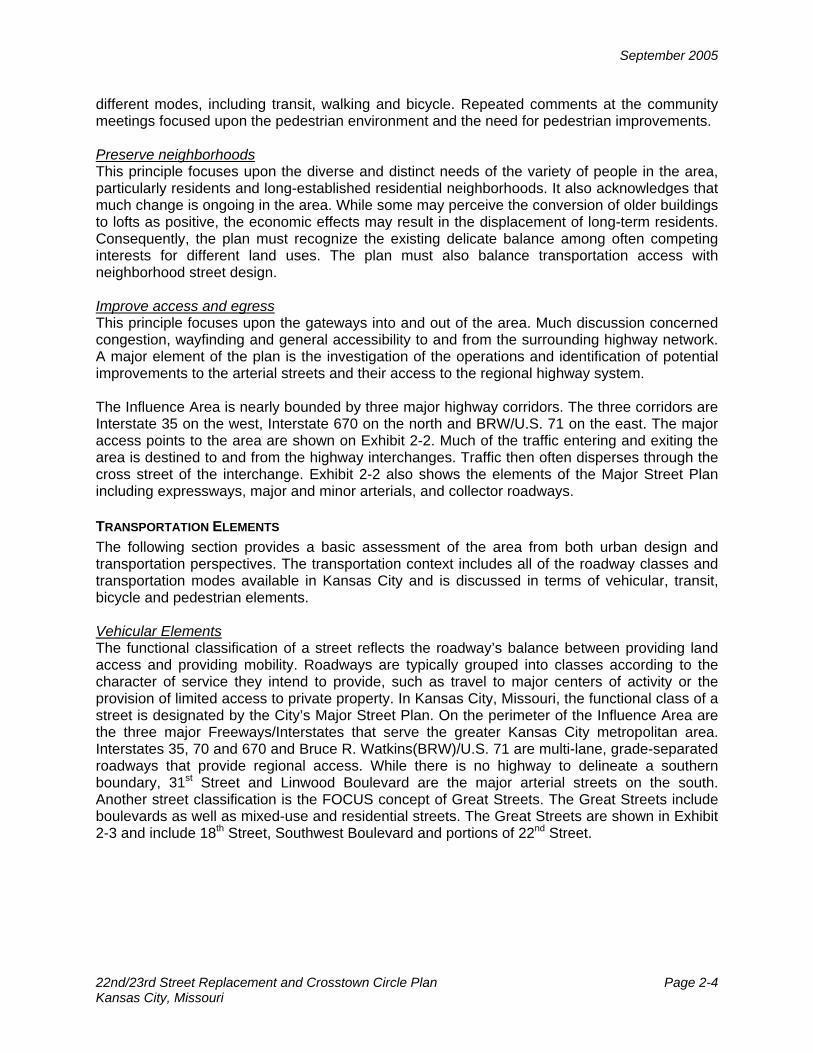
Exhibit 1-1 illustrates three main segments of the 22nd/23rd Street corridor from west to east, beginning at the I-35 crossing of Avenida de Cesar Chavez and extending to the interchange at I-70. The first segment includes the “connector” which is essentially from Southwest Boulevard to Main Street and was removed from the Major Street Plan in March 2000. The second segment is from McGee to Bruce R Watkins (BRW)/U.S. 71 which is currently under design and scheduled for construction. The third segment is from BRW/U.S. 71 east to I-70 that may utilize a one-way pair on 22nd and 23rd Streets. Exhibit 1-2 shows two former concepts for the Crossroad Circle and Crosstown Square from the City’s FOCUS Urban Core Plan and the Downtown Corridor Development Strategy Plan, often referred to as the “Sasaki” Plan. Both concepts envisioned targeting development incentives including retail, office, restaurant and entertainment as well as creation of a Special Benefits District.
Exhibit 1-1 - 22nd/23rd Street Concept Plan
Exhibit 1-2 - Crossroad Circle and Crosstown Square Concepts

September 2005
22nd/23rd Street Replacement and Crosstown Circle Plan Page 1-2 Kansas City, Missouri
The plan addresses two major issues: one of transportation improvements and the other of place-making or urban design. While these issues may be discussed in discrete terms, for the purposes of developing this plan they are considered inseparable and interrelated. In other words, any transportation improvement will intrinsically include urban design elements. Likewise, the place-making opportunity may be defined by transportation elements. A series of Working Papers were prepared to document the planning process and record the development of transportation and place-making concepts. These papers, along with other information, were posted on the study webpage www.kcplanningstudy.com. The following is a list of the Working Papers and Technical Memoranda:
Working Papers 101 – Issues Identification
102 –Design and Planning Context of Study Area 201 – Development and Screening of Transportation
Strategies and Place-Making Alternatives 301 – Alternatives Refinement and Evaluation
401 – The Preferred Plan (incorporated in the Report)
Technical Memoranda 101 – Developing the Travel Demand Model 201 – Existing and Projected Traffic Analysis
The Report includes summary material from all of the above Working Papers. The last Working Paper 401 – The Preferred Plan has not been issued as a separate Working Paper as it is the last section of the Report and contains refinements to the transportation strategies and place-making components from the completed Working Paper 301. Revisions to the documents are included with the Report documenting the entire process. Two CD’s are available for this Plan. One CD contains the Report, while the other CD contains copies of all the Working Papers and Technical Memoranda. Revisions to the Working Papers have also been made but the original issue date has not been changed. CONTEXT The 22nd/23rd Street Replacement and Crosstown Circle Plan’s Influence Area is bounded by Interstate 670 and Truman Road on the north; Woodland and the Bruce R. Watkins Frontage Road on the east; Linwood Boulevard and 33rd Street on the south; and the Kansas/Missouri State Line on the west. Within the Influence Area, a smaller Study Area was defined within which improvements were contemplated.
September 2005
22nd/23rd Street Replacement and Crosstown Circle Plan Page 1-3 Kansas City, Missouri
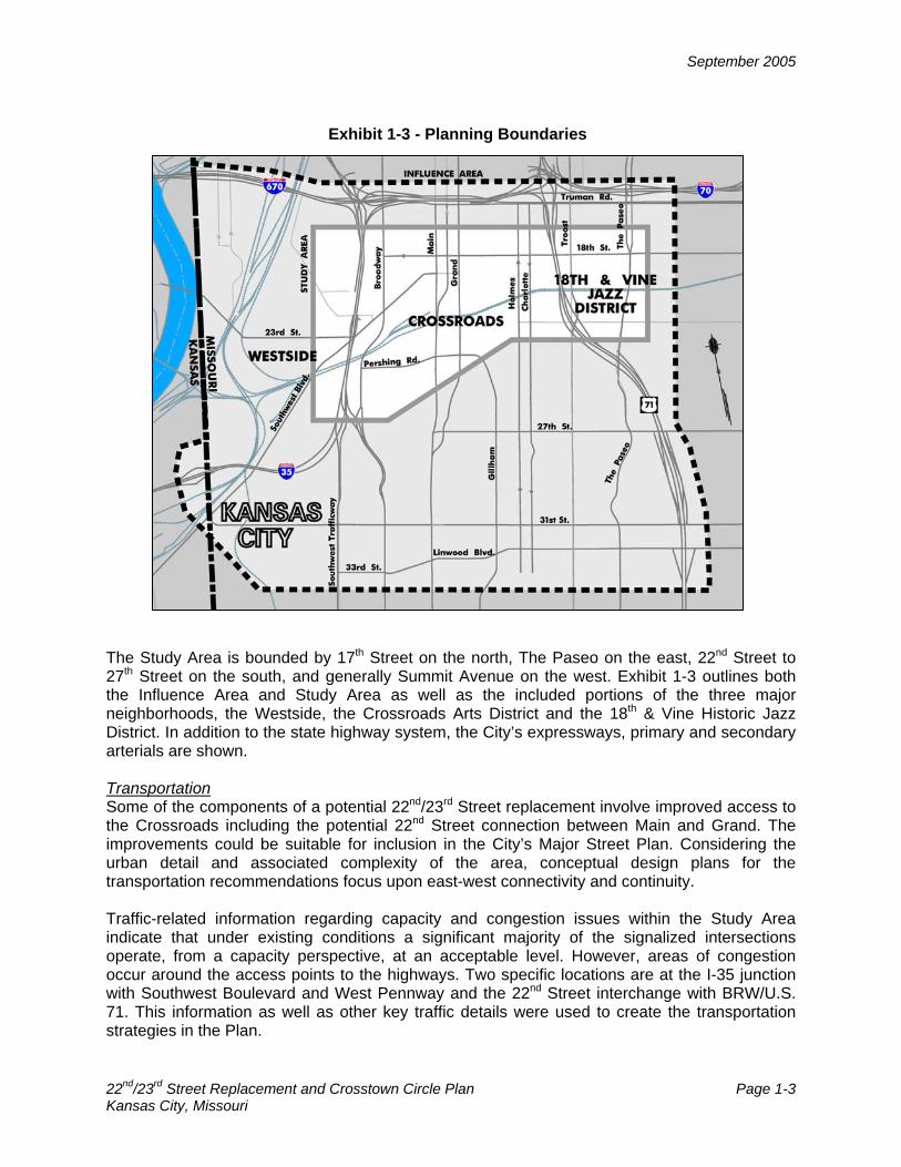
The Study Area is bounded by 17th Street on the north, The Paseo on the east, 22nd Street to 27th Street on the south, and generally Summit Avenue on the west. Exhibit 1-3 outlines both the Influence Area and Study Area as well as the included portions of the three major neighborhoods, the Westside, the Crossroads Arts District and the 18th & Vine Historic Jazz District. In addition to the state highway system, the City’s expressways, primary and secondary arterials are shown. Transportation Some of the components of a potential 22nd/23rd Street replacement involve improved access to the Crossroads including the potential 22nd Street connection between Main and Grand. The improvements could be suitable for inclusion in the City’s Major Street Plan. Considering the urban detail and associated complexity of the area, conceptual design plans for the transportation recommendations focus upon east-west connectivity and continuity. Traffic-related information regarding capacity and congestion issues within the Study Area indicate that under existing conditions a significant majority of the signalized intersections operate, from a capacity perspective, at an acceptable level. However, areas of congestion occur around the access points to the highways. Two specific locations are at the I-35 junction with Southwest Boulevard and West Pennway and the 22nd Street interchange with BRW/U.S. 71. This information as well as other key traffic details were used to create the transportation strategies in the Plan.
Exhibit 1-3 - Planning Boundaries

September 2005
22nd/23rd Street Replacement and Crosstown Circle Plan Page 1-4 Kansas City, Missouri
Currently, the design plans for 22nd Street, between McGee and BRW/U.S. 71, are complete and construction is set to start shortly. The remainder of the 22nd/23rd Street corridor, east to I-70, is on the City’s Capital Improvement Program through fiscal year 2008. Urban Design The major urban design element of the Plan is the linkage of the Westside, the Crossroads Arts District and the Jazz District. The product includes transportation solutions and urban design elements. The place-making element that will tie the Westside, the Crossroads Arts District and Jazz District was identified by the Plan’s participants as a major cultural corridor junction. Opportunities exist for public open space public-private partnerships as well as commercial development. The FOCUS Urban Core Plan contemplated the Crosstown Circle, near 18th Street and Main Street, to create a cultural, retail, office, restaurant and entertainment corridor including significant streetscape improvements, targeted development incentives, higher density mixed-use zoning, creation of a Special Benefits District, and a circulation shuttle bus system. Then the Downtown Corridor Development Strategy Plan, often referred to as the Sasaki Plan, identified a Crossroads Square. This square would be a new park, creating a focal point for the community with retail uses clustering around the park. It envisioned new development to fill in the gaps in the street facades and activities. Stakeholders in that process identified the need for parking to support any further development. The Crossroads Arts District, which makes up the majority of the Study Area, is generally defined by Interstate 670 on the north, Interstate 35 on the west, Troost Avenue on the east and the Kansas City Terminal Railroad tracks on the south. A piece of the Crossroads Arts District, that area south of 20th Street to the railroad tracks, between Broadway and Main Street, has become known as the Freighthouse District. The Crossroads area represents a piece of Kansas City’s industrial past. Much of the building stock in the area remains from a time of urban industrial development, now much of which is obsolete for modern, large-scale industrial purposes. Much of the building stock has remained vacant or been underutilized for the past several decades. However, over the past few years this area has experienced the benefits of a movement back to the city. The Crossroads has seen resurgence of redevelopment, although not as its original industrial roots but as an artist-oriented, commercial, and residential loft district, and is poised to continue that trend. Other districts in the area have also seen a resurgence of economic development and activity with housing in the Westside neighborhood, commercial and residential development in the Jazz District and the Downtown Loop, new office space at Crown Center and commercial opportunities at Union Station. The Westside is the historic center of the Hispanic community in Kansas City. Generally the Westside is recognized as the area between Interstate 670 on the north, Broadway on the east, 31st Street on the south, and the Missouri State Line to the west. This district is one of the oldest and most tightly-knit neighborhoods in Kansas City. Similarly, the 18th and Vine Jazz District has historically been a center of the African-American community. Generally, the Jazz District is recognized as the area between Truman Road on the north, Woodland Avenue on the east, 21st Street on the south, and Paseo Boulevard on the west. While some would argue that the center of the African-American community has moved, the city has gone to great lengths over the past 10 years to reinvigorate and recapture the history and energy of the Jazz District. This district represents not only the heyday of jazz in Kansas City but also in the United States. The Westside and the Jazz District represent the

September 2005
22nd/23rd Street Replacement and Crosstown Circle Plan Page 1-5 Kansas City, Missouri
diversity of the study area and also present two different communities that are undergoing similar changes: preservation and redevelopment. The assessment of who we are is important to answer the question of who we want to be. By looking at the urban design elements present, such as building heights, mass and scale, design, and materials, streetscape, traffic patterns, land use and zoning, current and future projects and their designs, we begin to answer the question of who we are. Based on this answer, we can define who we want to be. Process Development of the Plan evolved through four distinct phases beginning with the Assessment of Existing Conditions that includes traffic operations, planning context and the establishment of a set of guiding principles. This information helped to develop a series of alternatives, specifically four transportation strategies and three macro place-making alternatives. Through screening and refinement, these strategies evolved to specific projects and plans through such concepts as the “road diet” and a series of pocket parks. With continued evaluation and refinement a preferred plan has emerged with selected demonstration projects. Exhibit 1-4 illustrates the process flow chart noting how Steering Community and community input was utilized.
Exhibit 1-4 – Process Flow Chart
ASSESSMENT OF EXISTING CONDITIONS
TRANSPORTATION STRATEGIES PLACE MAKING ALTERNATIVES
PROJECTS AND PLACES
PREFERRED
DEVELOPMENT OF ALTERNATIVES
SCREENING AND REFINEMENT
EVALUATION AND SELECTION
STEERING COMMITTEE
INPUT
COMMUNITY INPUT
ASSESSMENT OF EXISTING CONDITIONS
TRANSPORTATION STRATEGIES PLACE MAKING ALTERNATIVES
PROJECTS AND PLACES
PREFERRED
DEVELOPMENT OF ALTERNATIVES
SCREENING AND REFINEMENT
EVALUATION AND SELECTION
STEERING COMMITTEE
INPUT
COMMUNITY INPUT

September 2005
22nd/23rd Street Replacement and Crosstown Circle Plan Page 1-6 Kansas City, Missouri
The Steering Committee consisted of 26 members. Exhibit 1-5 lists the members in alphabetical order of their organizations.
Exhibit 1-5 – Steering Committee Members
18th & Vine Historic District.............................................................................. Ron Matlock Historic Jazz Redevelopment Authority ....................................................... Juanita Moore Kansas City Area Transportation Authority ..................................................... Jim Pritchett BNIM ................................................................................................................Tom Nelson Center City Neighborhood............................................................................. Gloria Nelson Crossroads Community Association ..............................................David Dowell (co-chair) .....................................................................................................................Robyn Nichols Crown Center ................................................................................................Tom Peterson Downtown Council ............................................................................................ Bill Dietrich ........................................................................................................................Steve Taylor Freighthouse District. ...................................................................................Michael Frisch Frye and Company................................................................................................Bob Frye Greater Kansas City Community Foundation.....................Jean-Paul Chaurand (co-chair) Guadalupe Center.....................................................................................Richard Olivares HEDFC...........................................................................................................Ken Bacchus Hispanic Chamber of Commerce ........................................................................Cici Rojas Jazz District Redevelopment Corporation.......................................................... Al Fleming Levitt Enterprises ............................................................................................... Tom Levitt Longfellow/Dutch Neighborhood................................................................. Parris Johnson MoDOT......................................................................................... Linda Clark (LeAnn Kell) Kansas City Parks and Recreation Board of Commissioners ......................... Sandra Aust Performing Arts Center .................................................................................... Ken Dvorak Resident ......................................................................................................... Elsa Bautista Trabon Consulting............................................................................................Tom Trabon Union Station Kansas City, Inc....................................................................... Turner White Western Missouri Mental Health ...................................................................Gloria Joseph Westside Housing Organization...................................................................Jerry Shechter
Through the course of the Plan’s development, numerous Steering Committee meetings were held throughout the Westside, the Crossroads Arts District and the Jazz District. This report documents the process as well as the recommendations. As a summary document it provides highlights of the process. Further descriptions of the process are included in the Working Papers. The report is organized into three basic sections: Area Assessment; Alternatives Developed, Screened and Refined; and Developing the Plan.

September 2005
22nd/23rd Street Replacement and Crosstown Circle Plans Page 2-1 Kansas City, Missouri
AREA ASSESSMENT The area assessment includes the discussion of a set of guiding principles, the area’s context in terms of transportation elements and urban design and an operational capacity assessment for existing and future conditions. GUIDING PRINCIPLES The guiding principles synthesize common issues so that an integrated approach is used to provide guidance in the development of alternatives and to aid in the assessment of the different alternatives. This section describes the methodologies used to create the guiding principles. A process was used to obtain specific input about certain topics, such as transportation and land use, while still providing participants the opportunity to express broader concerns. The process also provided a prioritization of the issues. This process was used with various stakeholders at Steering Committee meetings and several broader community meetings. Through open discussion, participants summarized the issues as much as possible. Through subsequent community meetings the initial issues were validated. Based upon the discussion, the following set of guiding principles was developed:
• Create parks and open space • Create a unique vision • Enhance transportation choices • Preserve neighborhoods • Improve access and egress
A separate meeting held on the Westside identified key issues as:
• Honor and respect the original risk takers
• Actively control vehicle speed • Avoid disruption of existing
community • Give consideration to existing
residents The primary focus of the issues expressed at the Westside community meeting was the uniqueness of the Westside as a long-standing residential community that experiences the negative effects of through traffic. Transportation issues focused upon the need for neighborhood traffic control to protect children, particularly around the community center and the library, by narrowing streets or installing traffic circles. Summit Avenue was also specifically noted as having speeding traffic. Neighborhood issues focused upon the desire to maintain a residential neighborhood focus with continued representation from the Westside. A meeting held in the Crossroads identified the key issues as:
• Interstate 35 ramp design • Beautification, walkability and building preservation • Balancing pedestrian and auto traffic • Improvement of pedestrian-friendly environment and access to businesses • Improvement of other infrastructure
A common theme among these issues is the quality of pedestrian mobility in order to make the area more friendly and attractive. This can be achieved by improving, in an integrated manner, the elements experienced during walking, such as streetscape and the street presence of buildings through store-front windows. The major transportation issue was access to I-35 and the various routes to the western gateway of the Crossroads, including West Pennway, Southwest Boulevard and Broadway. The issue of beautification also emerged in a less formal

September 2005
22nd/23rd Street Replacement and Crosstown Circle Plans Page 2-2 Kansas City, Missouri
landscape language of burying overhead utility lines to diminish visual presence and widening existing narrow sidewalks. An informal strengths, weaknesses, opportunities and threats (SWOT) exercise was conducted with the Steering Committee to solicit views on any issue that may affect the subject communities. The members were also asked to list three things to keep in their neighborhood and three things to change. Common themes were evident from these exercises. As strengths, many listed the major identifiable destinations in the area such as Crown Center, Union Station, Hospital Hill, the Freighthouse District and the arts community. Often the weakness and opportunity areas were combined with a common focus on the numerous surface parking lots in the area. The location and presence of surface parking was readily apparent from the aerial photograph as members marked these numerous areas. Some focused upon specific large areas of parking while others identified smaller lots in a more prominent location. While currently viewed as a weakness, these surface parking lots provide opportunities for development or potential open space. Other identified weaknesses were access points, specifically to Interstate 35 and the 18th & Vine area. Few threats were identified with the exception of an area along the south loop of I-670 which serves as a physical separation between the Crossroads and Downtown. For the three things to keep, the common elements were:
• Existing Buildings, referring to unique and historic elements
• Pedestrian qualities, referring to the smaller scale blocks and higher urban density
• Diversity of uses, referring to the cultural and ethnic focus
For the three things to change, the common suggestions were to:
• Create more and better pedestrian friendly routes
• Eliminate the large number of surface parking lots
• Address the lack of central space and greenery
Pedestrian issues appear in both the keep and change categories. From comments made at the community meetings, this may mean that the overall physical fabric of a walkable neighborhood (small blocks, buildings at the street line) is available but the human-scale details to make for an enjoyable experience are not consistently present. Elements of the guiding principles:
• Create parks and open space • Create a unique vision • Enhance transportation choices • Preserve neighborhoods • Improve access and egress
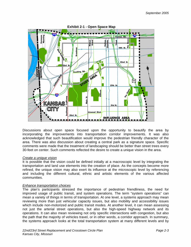
are discussed in more detail in the following sections. Create parks and open space In many ways this principle becomes self evident when viewing a map of existing open-space in the Influence Area and the Study Area. Refer to Exhibit 2-1. There are several large tracts of open space, such as Penn Valley Park and Liberty Memorial, as well as smaller neighborhood parks. However, open space is generally rare within the Crossroads area, present only in portions of the boulevard system and small, often private, open spaces.
September 2005
22nd/23rd Street Replacement and Crosstown Circle Plan Page 2-3 Kansas City, Missouri
Discussions about open space focused upon the opportunity to beautify the area by incorporating the improvements into transportation corridor improvements. It was also acknowledged that such beautification would improve the pedestrian friendly character of the area. There was also discussion about creating a central park as a signature space. Specific comments were made that the treatment of landscaping should be better than street trees every 30-feet on center. Such comments reflected the desire to create a unique vision in the area. Create a unique vision It is possible that the vision could be defined initially at a macroscopic level by integrating the transportation and land use elements into the creation of place. As the concepts become more refined, the unique vision may also exert its influence at the microscopic level by referencing and including the different cultural, ethnic and artistic elements of the various affected communities. Enhance transportation choices The plan’s participants stressed the importance of pedestrian friendliness, the need for improved usage of public transit, and system operations. The term “system operations” can mean a variety of things in terms of transportation. At one level, a systems approach may mean reviewing more than just vehicular capacity issues, but also mobility and accessibility issues which include non-motorized and public transit modes. At another level, it can mean assessing not just the arterial street operations, but also the high-speed highway network and its operations. It can also mean reviewing not only specific intersections with congestion, but also the path that the majority of vehicles travel, or in other words, a corridor approach. In summary, the systems approach looks at the total transportation system at many different levels and by
Exhibit 2-1 - Open Space Map
September 2005
22nd/23rd Street Replacement and Crosstown Circle Plan Page 2-4 Kansas City, Missouri
different modes, including transit, walking and bicycle. Repeated comments at the community meetings focused upon the pedestrian environment and the need for pedestrian improvements. Preserve neighborhoods This principle focuses upon the diverse and distinct needs of the variety of people in the area, particularly residents and long-established residential neighborhoods. It also acknowledges that much change is ongoing in the area. While some may perceive the conversion of older buildings to lofts as positive, the economic effects may result in the displacement of long-term residents. Consequently, the plan must recognize the existing delicate balance among often competing interests for different land uses. The plan must also balance transportation access with neighborhood street design. Improve access and egress This principle focuses upon the gateways into and out of the area. Much discussion concerned congestion, wayfinding and general accessibility to and from the surrounding highway network. A major element of the plan is the investigation of the operations and identification of potential improvements to the arterial streets and their access to the regional highway system. The Influence Area is nearly bounded by three major highway corridors. The three corridors are Interstate 35 on the west, Interstate 670 on the north and BRW/U.S. 71 on the east. The major access points to the area are shown on Exhibit 2-2. Much of the traffic entering and exiting the area is destined to and from the highway interchanges. Traffic then often disperses through the cross street of the interchange. Exhibit 2-2 also shows the elements of the Major Street Plan including expressways, major and minor arterials, and collector roadways. TRANSPORTATION ELEMENTS The following section provides a basic assessment of the area from both urban design and transportation perspectives. The transportation context includes all of the roadway classes and transportation modes available in Kansas City and is discussed in terms of vehicular, transit, bicycle and pedestrian elements. Vehicular Elements The functional classification of a street reflects the roadway’s balance between providing land access and providing mobility. Roadways are typically grouped into classes according to the character of service they intend to provide, such as travel to major centers of activity or the provision of limited access to private property. In Kansas City, Missouri, the functional class of a street is designated by the City’s Major Street Plan. On the perimeter of the Influence Area are the three major Freeways/Interstates that serve the greater Kansas City metropolitan area. Interstates 35, 70 and 670 and Bruce R. Watkins(BRW)/U.S. 71 are multi-lane, grade-separated roadways that provide regional access. While there is no highway to delineate a southern boundary, 31st Street and Linwood Boulevard are the major arterial streets on the south. Another street classification is the FOCUS concept of Great Streets. The Great Streets include boulevards as well as mixed-use and residential streets. The Great Streets are shown in Exhibit 2-3 and include 18th Street, Southwest Boulevard and portions of 22nd Street.

September 2005
22nd/23rd Street Replacement and Crosstown Circle Plan Page 2-5 Kansas City, Missouri
Exhibit 2-3 Great Streets
Exhibit 2-2 - Highway Access Points
September 2005
22nd/23rd Street Replacement and Crosstown Circle Plan Page 2-6 Kansas City, Missouri
Personal vehicular travel is the dominant form of transportation in Kansas City and therefore makes parking an important element of any transportation and land use plan. Public on-street parking and private off-street parking exist in many forms. Public on-street parking is typically parallel parking without meters; however, the on-street parking is typically limited by time of day and duration. Many streets in the area restrict parking during peak travel times in the direction of travel of the majority of motorists. This provides an extra travel lane on some streets in the area. There are several private off-street parking lots and structures in the area. Near Crown Center there are several private parking structures for employees as well as several large surface parking lots with shuttle bus service to the office buildings and hospitals. Transit Elements Numerous Kansas City Area Transit Authority (KCATA) bus routes serve the area from all directions. Many streets, including 18th Street, Main Street, Grand Boulevard and Pershing Road, carry buses that service areas to and from the east (typically west of I-70), south (to approximately 85th Street) and north (Central Business District). With the State Line immediately to the west, the KCATA bus routes may be considered local. Union Station and Crown Center are considered the hub of the system with several transfer stops. Exhibit 2-4 shows Metro Bus routes as well as the proposed Bus Rapid Transit system. The KCATA has recently implemented a Bus Rapid Transit (BRT) route, called the Max, essentially along Main Street in the Study Area. Bus stop locations include 31st Street on Main, Crown Center on Grand, Union Station/Amtrak on Main, mid-block south of 19th Street on Main, and 13th Street on Wyandotte. BRT operations began in July 2005. Smart Moves is a 10- to 12-year regional transit plan developed by the KCATA, the JO, the Bus and the Mid-America Regional Council. The plan identifies potential transit centers with several Rapid Rider lines shown conceptually to pass through the Crossroads, Union Station and the Jazz District. Rapid Riders are designed as much as possible like light rail transit. Bicycle Elements The bicycle is a continuously growing form of transportation for all types of trips, whether for commuting or recreational purposes. The City of Kansas City, Missouri recently developed Bike KC! that was approved by the City Plan Commission in July 2001 and later adopted by the City Council in August 2002. This Plan identifies several phases of potential on-street facilities including 19th and 29th Streets, Southwest Boulevard, Vine Street, The Paseo, Holmes and Charlotte as well as West Pennway and Summit. Identified bicycle routes by phases are shown in Exhibit 2-5. To accommodate potential on-street facilities that would follow the guidelines for collectors or arterials without parking, changes would need to occur to the roadway section to accommodate bicycles. A recently constructed bicycle and walking facility is the Heritage Trail located on the Westside with a multi-use path along West Pennway.
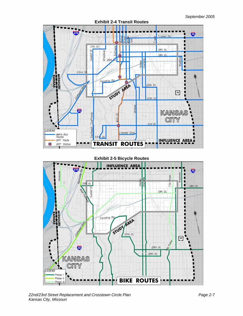
September 2005
22nd/23rd Street Replacement and Crosstown Circle Plan Page 2-7 Kansas City, Missouri
Exhibit 2-4 Transit Routes
Exhibit 2-5 Bicycle Routes

September 2005
22nd/23rd Street Replacement and Crosstown Circle Plan Page 2-8 Kansas City, Missouri
Pedestrian Elements Sidewalks are typically available but because the Study Area is within an older portion of the City, sidewalk conditions can often be poor. The City of Kansas City, Missouri has recently completed its Walkability Plan that was adopted by the City Council in March 2003. This Plan went through several case studies of areas within the Study and Influence Area, including 18th & Vine, Crown Center and Downtown. Beyond identifying specific pedestrian corridors, such as Broadway, Main Street, Grand Boulevard, Oak/Gilham, Truman Road, The Paseo, Vine Street, Woodland, 18th and 22nd Streets, the plan prioritized pedestrian improvements with probable costs, shown here in Exhibit 2-6. Construction of a pedestrian bridge across the railroad tracks to connect Union Station and the Freighthouse District is proposed. The 18th & Vine area utilizes traffic calming elements such as speed humps to assist in slowing traffic on 18th Street between The Paseo and Woodland.
Existing Traffic Operations An important element used to evaluate transportation conditions is the volume of traffic. Traffic volumes were collected from the city’s count program and supplemented by consultant collected turning movement counts. Data at over 120 intersections were collected. Typically, A.M. and P.M peak hour traffic volumes are collected from 7:00 to 9:00 A.M. and 3:00 to 6:00 P.M., respectively. Within these time periods the highest volume entering the intersection during one hour is selected and used for analysis at the intersection. The pattern of travel is predominantly dictated by the major access points to the Study Area, namely the I-35 interchange at Southwest Boulevard/West Pennway and BRW/U.S. 71 at 22nd
Exhibit 2-6 Pedestrian Improvements

September 2005
22nd/23rd Street Replacement and Crosstown Circle Plan Page 2-9 Kansas City, Missouri
Street. Travel is targeted to an area focused around Hospital Hill, Crown Center and Union Station. This is evidenced through the east/west patterns during the peak hours. On the major east/west streets that connect to I-35, the heavy volume is eastbound during the A.M. peak hour and westbound during the P.M. peak hour. The opposite situation occurs for the major east/west streets that connect to BRW/U.S. 71. From BRW/U.S. 71, the major direction of travel is westbound in the A.M. peak hour and eastbound in the P.M. peak hour. North/south travel in the Influence Area does show some concentration in the Crown Center area but these roadways predominantly show that drivers are using them for longer distance travel. Most of the north/south routes in this area (Broadway, Main Street, Grand Boulevard, and Oak/Gillham Streets) connect the Plaza and southern parts of Kansas City to the Central Business District. The ability of drivers to choose many paths to their destination provides a natural equilibrium over the grid street system, and consequently the volume of traffic in this area is considered moderate. However, there are still some streets that carry higher volumes than others and are effectively the central spine for the area. The spine includes Broadway, Pershing Road, Grand Boulevard and 20th Street. Exhibit 2-7 provides information on the peak traffic volume (either an AM or PM peak period) by number of vehicles per hour (vph) on these heavily traveled streets. These volumes represent the total traffic volume, for both directions, on the street. Consequently, some one-way pair streets are combined.
Exhibit 2-7 Heavily Traveled Streets
Street Total Volume Pershing Road 1,400 vph
Grand Boulevard 1,300 vph Broadway/West Pennway 1,100 vph
Southwest Boulevard 1,000 vph Main Street/Walnut Street 1,000 vph
Holmes/Charlotte 1,000 vph 20th Street 1,000 vph 27th Street 1,000 vph
Oak Street/Gillham 900 vph 22nd Street 800 vph
The signalized study intersections were evaluated based on the methodologies outlined in the Highway Capacity Manual, 2000 Edition. The operating conditions at an intersection are graded by the “level of service” experienced by drivers. Level of service (LOS) describes the quality of traffic operating conditions and is rated from “A” to “F”. The LOS rating deemed acceptable varies by community, facility type and traffic control device. For signalized intersections, level of service and average delay relate to all vehicles using the intersection. In Kansas City, LOS D is identified as the minimum desirable goal for signalized intersections.
Over one hundred signalized intersections were analyzed in the study area with over 98% of the intersections operating at LOS C or better. There are no intersections that result in LOS E or F operation during the time periods analyzed. Four intersections operate at the minimum desirable level of service threshold. In the A.M. peak hour Linwood Boulevard and The Paseo as well as the I-35 Exit at West Pennway operate at LOS D. In the P.M. peak hour Pershing Road and West Pennway as well as 33rd Street and Broadway operate at LOS D. Overall, the intersections in this area operate with low delays, but this is not the only operational element used to evaluate a signalized intersection. Some intersections experience long queues during the peak hour. Many motorists may travel circuitous routes to their destinations to avoid these delays. Exhibit 2-8 shows two congestion areas described below.

September 2005
22nd/23rd Street Replacement and Crosstown Circle Plan Page 2-10 Kansas City, Missouri
Near the I-35 interchange of Southwest Boulevard/West Pennway long queues of traffic exist during the peak hours of travel. In the A.M. peak hour the queues typically start on the northbound exit ramp and then filter through the West Pennway and Southwest Boulevard intersection to the junction of Broadway and Southwest Boulevard. At this point traffic either turns south onto Broadway/West Pennway or continues northeasterly on Southwest Boulevard to 20th Street. This pattern is generally repeated in the opposite direction in the P.M. peak hour with long queues starting in the northbound left-turn lane at Broadway/West Pennway and on southwest bound Southwest Boulevard. Many times the queue from the I-35 entrance/exit ramps extends through the Broadway/West Pennway and Southwest Boulevard intersection in the P.M. peak hour.
Another area of congestion occurs along 22nd Street in the Hospital Hill area. Since 22nd Street is a service interchange on BRW/U.S. 71, it is important to provide drivers with an accessible arterial route. Along 22nd Street long westbound queues exist in the A.M. peak hour. Many times the westbound queue at Charlotte extends back to Campbell Street and even to the interchange. In the P.M. peak hour, long eastbound queues result at the unsignalized intersections at Holmes Road and Charlotte Street. The programmed improvements to 22nd Street as a four-lane facility should help ease these congestion problems.
Exhibit 2-8 Congestion Areas
Westbound 22nd Street during AM peak hour
Westbound West Pennway during PM peak hour
September 2005
22nd/23rd Street Replacement and Crosstown Circle Plan Page 2-11 Kansas City, Missouri
Future Conditions and Traffic Operations This section includes a summary of committed and proposed projects shown on Exhibit 2-9. Each project is referenced in the Exhibit as a letter. A major committed project in the study area is the improvement to 22nd Street from McGee to Harrison. Essentially the project entails widening 22nd Street to four-lanes, removing parking and straightening the intersection of 22nd Street at Oak Street and Gillham Road. A traffic signal is proposed at the Oak/Gillham intersection. Reference letter A. The 31st Street bridge over Wyandotte is slated for replacement at a cost of $1.15 million. In conjunction with the 2555 Grand office tower development, a left-turn lane on 31st Street’s west leg at Main Street has recently been constructed. Reference letter B. The Missouri Department of Transportation has recently prepared a Major Investment Study on Interstate 70 whose western limits include the Downtown Loop. A series of potential improvements have been conceptualized and include:
• Removal of the Truman Road eastbound on-ramp, east of Broadway • Addition of on- and off-ramps at Walnut Street, and at Grand Avenue • A High Occupancy Vehicle (HOV) lane entrance at 13th Street and Charlotte and • Directional ramps to and from BRW/U.S. 71 to I-70 to and from the east.
These elements are referenced as letters C1 through C4. The Kansas City Parks and Recreation Department is the lead agency advancing a roadway reconfiguration project on Gillham Road between McGee Trafficway and 31st Street. This project stemmed from the proposed residential and mixed-use development proposals of Union Hill and Gillham Row. The concept is to re-stripe the roadway section from six-lanes to five lanes (two lanes in each direction with a center two-way-left-turn lane). Reference letter D. The update to the Crown Center Master Plan was recently approved by City Council. While mixed-use development is proposed over several phases, a potential transportation improvement includes widening 27th Street between Grand Boulevard and Gillham Road to five lanes. Reference letter E. Similar to the existing conditions assessment, a capacity analysis was conducted using the 2020 future traffic volume projections in combination with the existing lane configurations to determine how selected intersections will operate without capacity improvements. Since over 98% of the existing study intersections operated at or above LOS C, not all of the intersections were selected for future analysis. The intersections selected for future analysis were chosen because they experienced moderate to high traffic volume increases, were part of a congested area identified under existing conditions or may be part of a potential transportation option. Nearly 30 signalized intersections were reviewed with a specific focus along the 18th Street, 19th Street, 20th Street, 22nd Street and 31st Street corridors as well as along portions of Southwest Boulevard and Pershing Road. Over the projected period, traffic volumes along these corridors continue to grow, some at a greater rate than others. Along the 18th Street corridor, peak hour traffic volumes increase by approximately 150 vehicles or nearly by a third. Along the 19th Street corridor, peak hour traffic volumes increase by approximately 300 vehicles or nearly by two-thirds. A comparison of existing and projected traffic volumes along heavily traveled streets is shown in Exhibit 2-10.

September 2005
22nd/23rd Street Replacement and Crosstown Circle Plan Page 2-12 Kansas City, Missouri
Exhibit 2-10 Existing and Projected Traffic Volumes along Heavily Traveled Streets
Street 2003 Volume 2020 Volume
Raw Increase
Pershing Road 1,400 vph 2,050 vph 650 Grand Boulevard 1,300 vph 2,050 vph 750
Broadway/West Pennway 1,100 vph 2,150 vph 1,050 Southwest Boulevard 1,000 vph 1,550 vph 550
Main Street/Walnut Street 1,000 vph 2,000 vph 1,000 Holmes/Charlotte 1,000 vph 1,250 vph 250
20th Street 1,000 vph 1,450 vph 450 Oak Street/Gillham 900 vph 1,400 vph 500
22nd Street 800 vph 1,500 vph 700 While projected traffic volumes along the 19th Street corridor show a sizeable percentage increase, a greater increase in raw volume occurs along 22nd Street, the Main/Walnut pair and Broadway. The increase along 22nd Street can be associated with the committed improvements to four-lanes. Main Street in the downtown loop is to be converted from one-way to two-way traffic, and major development initiatives at the edge of the Loop including the Bartle Hall expansion and other office development are likely to contribute to the greater increases in traffic volumes. Overall, review of the selected intersections continues to show operations with low levels of delays. There are two intersections that result in LOS E or F operation during the time periods
Exhibit 2-9 Committed and Proposed Projects

September 2005
22nd/23rd Street Replacement and Crosstown Circle Plan Page 2-13 Kansas City, Missouri
analyzed with the projected future volumes. In the A.M. peak hour Pershing Road and Main Street operates at LOS E and in the P.M. peak hour SW Boulevard and Broadway Avenue operates at LOS F. PLANNING AND URBAN DESIGN The proposed land uses for the area, as prescribed by the existing city planning documents, paint differing pictures. The adopted land use plan for the area, the Downtown Industrial Area Plan, as shown in Exhibit 2-11, call for a commercial corridor around Main Street from the Downtown Loop to Penn Valley Park, including the area around Union Station and Crown Center. The plan originally prepared in the 1970’s promotes industrial uses in the area of Crossroads between Broadway and Main and predominately institutional uses in the areas east of Main to Troost. This plan also proposes industrial uses for the 18th and Vine area and predominately residential uses for the Westside. In the last five years the plan has been amended to call for increased mixed use development. The Downtown East Area Plan, the adopted land use plan for the 18th & Vine area, proposes a mix of industrial, commercial and residential uses. This plan was created prior to the 18th & Vine redevelopment effort. Recent development plans adopted by the city promote a mixture of commercial and residential use. The Westside Area Plan, the adopted land use plan, recommends predominately residential uses for the Westside District west of Interstate 35, and a mixture of uses east of I-35 to Broadway. This plan was completed in 1997 through an extensive public participation process by the residents of the Westside. The FOCUS Urban Core Plan, the City’s Comprehensive Plan, adopted by the City in 1997 paints a picture of a mixed-use urban environment and is shown on Exhibit 2-12. The plan proposed three different mixed-use concepts for the Crossroads and Jazz Districts, which would allow a mix of residential, commercial and light industrial uses in any location. Similar to the Downtown Industrial Area Plan, FOCUS recommends that the land uses in the Westside District remain predominately residential. What differentiates the proposed concepts is the allowable density. The densities that are proposed would reaffirm the area as an urban, higher density area of the city. The current zoning pattern in the Crossroads area reflects the once dominant industrial development pattern. However, similar to land use, these patterns seem to be out of date. The current zoning pattern reflects a strong commercial corridor along Main Street, between the Downtown Loop and Crown Center. The commercial corridor is flanked east and west by expansive areas of industrially zoned property. On the periphery of the study area, specifically in the Westside and the Jazz District, are some properties zoned institutional and residential. The current zoning pattern reflects a practice dating back to the 1920’s that seeks to separate uses into distinct categories based on the type and intensity of the use. This zoning technique has been widely used in the United States since its inception. Similar to the proposed land use issues, the FOCUS Plan makes recommendations regarding the future zoning in the Crossroads area. In concert with the proposed mixed-use land use concepts, mixed-use zoning categories are proposed by the plan. Three different mixed-use zoning categories would govern the development/redevelopment of the Crossroads area. Again similar to the land use concepts, the defining factor with each proposed zoning category is density.

September 2005
22nd/23rd Street Replacement and Crosstown Circle Plan Page 2-14 Kansas City, Missouri
Exhibit 2-11 Proposed Land Use Plan
Exhibit 2-12 FOCUS Urban Core Plan
September 2005
22nd/23rd Street Replacement and Crosstown Circle Plan Page 2-15 Kansas City, Missouri
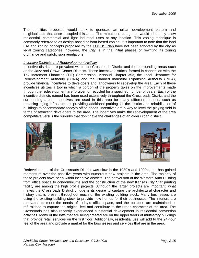
The densities proposed would seek to generate an urban development pattern and neighborhood that once occupied this area. The mixed-use categories would inherently allow residential, commercial and light industrial uses at any location. This zoning technique is commonly referred to as design-based or form-based zoning. It is important to note that the land use and zoning concepts proposed by the FOCUS Plan have not been adopted by the city as legal zoning categories; however, the City is in the initial phases of rewriting its zoning ordinance and subdivision regulations. Incentive Districts and Redevelopment Activity Incentive districts are prevalent within the Crossroads District and the surrounding areas such as the Jazz and Crown Center Districts. These incentive districts, formed in connection with the Tax Increment Financing (TIF) Commission, Missouri Chapter 353, the Land Clearance for Redevelopment Authority (LCRA) and the Planned Industrial Expansion Authority (PIEA), provide financial incentives to developers and landowners to redevelop the area. Each of these incentives utilizes a tool in which a portion of the property taxes on the improvements made through the redevelopment are forgiven or recycled for a specified number of years. Each of the incentive districts named has been used extensively throughout the Crossroads District and the surrounding areas. Incentives are used in this area for many different reasons, such as replacing aging infrastructure, providing additional parking for the district and rehabilitation of buildings to accommodate today’s office needs. Incentives are a way to level the playing field in terms of attracting developers to the area. The incentives make the redevelopment of the area competitive versus the suburbs that don’t have the challenges of an older urban district.
Redevelopment of the Crossroads District was slow in the 1980’s and 1990’s, but has gained momentum over the past five years with numerous new projects in the area. The majority of these projects have been within incentive districts. The conversion of the Western Auto Building from office space to condominiums and the construction of the new Kansas City Star printing facility are among the high profile projects. Although the larger projects are important, what makes the Crossroads District unique is its desire to capture the architectural character and history that is present throughout much of the existing building stock. Many businesses are using the existing building stock to provide new homes for their businesses. The interiors are renovated to meet the needs of today’s office space, and the outsides are maintained or refurbished to capture the original feel and contribute to the urban character of the area. The Crossroads has also recently experienced substantial development in residential conversion activities. Many of the lofts that are being created are on the upper floors of multi-story buildings that provide retail services on the first floor. Additionally, residential use will add to the 24-hour feel of the area and provide a market for the businesses and services that are in the area.

September 2005
22nd/23rd Street Replacement and Crosstown Circle Plan Page 2-16 Kansas City, Missouri
Urban Design Elements To protect the unique quality of the Study Area it is important to identify those characteristics and qualities that make the Study Area unique and to build on those assets. One of the objectives of this Plan is to identify those urban design assets and protect, enhance and emulate them as the area develops in the future. As the area was originally developed in the late 1800s and early 1900s, much of the building stock and infrastructure is approximately 100 years old. The general theme of the building stock remains industrial in nature, just as it was developed. The red brick and stone, the full site development pattern, and the prevailing two to five story heights characterize this building type. The lack of reliance on the automobile allowed every piece of a development site to be used for the building. The area of the Crossroads east of Oak Street has lost much of the old industrial character and been replaced by new, suburban industrial examples for the most part. In addition to the general building stock being an urban design theme, the Crossroads District has some specific, significant buildings that could provide a theme for the future design of the Crossroads. Structures like the original Kansas City Star, Western Auto, Nabisco/Stuart Hall and TWA buildings are all a part of the area and contribute to the character of the Crossroads. The general building stock can play an important role in the redevelopment of the Crossroads from an economic and design perspective. New structures should contribute to the future vision of the Crossroads because these projects can have a large impact on identity. The streets and streetscape in the area generally lack cohesion. While Crown Center, 18th and Vine and a few streets such as Grand Avenue have streetscape themes including plantings, banners and street furniture, streetscape is not an identifying theme outside of these areas. There is very little that differentiates the streets in the Crossroads District from those in the Downtown, the River Market or in the West Bottoms. Most of the streets have curbs, gutters and sidewalks but for the most part little else has been done to enhance the public space along the streets. The one thing that is different about pieces of the Crossroads from almost any other place in the city is that the streets provide some of the “place-making elements” with which people identify. In conjunction with the building form and placement, the streets can contribute to the future urban design elements of the Crossroads.

September 2005
22nd/23rd Street Replacement and Crosstown Circle Plan Page 3-1 Kansas City, Missouri
ALTERNATIVES DEVELOPMENT, SCREENING AND REFINEMENT TRANSPORTATION STRATEGIES DEVELOPMENT From a philosophical approach the Transportation Strategies are based upon four major components including:
• Needs-based assessment • Functional use of street network • Long-range planning integration • Multi-modal and context sensitive
The needs-based assessment focuses upon two major congestion areas, both of which are associated with access to and from the highway. The Westside congestion point is at the I-35 interchange with West Pennway and Southwest Boulevard. The Eastside congestion point is at the BRW/U.S. 71 interchange with 22nd Street. The southbound ramp configuration at this interchange extends to The Paseo. Part of the needs-based assessment is to develop and evaluate various improvement options at these locations. Currently, improvements are funded on 22nd Street between McGee and Harrison. The improvements involve roadway widening from two-lanes to four-lanes, roadway realignment, and installation of a traffic signal at the Oak/Gillham Road intersection. Further improvements to be investigated include the extension of 22nd Street and associated improvements between Main Street and McGee. In a similar manner to 22nd Street, access improvement options to I-35 have been investigated. The main focus is upon the two closely-spaced intersections of West Pennway and Southwest Boulevard and Southwest Boulevard and Broadway. Such options are typically developed in an incremental manner. It may start with minor access management and queue management techniques, followed by creating one larger signalized intersection or pulling the intersections further apart. New roadway alignments may be explored that would restrict various turning movements. Even a roundabout was considered a potential option. In conjunction with these arterial improvements, the interstate ramps were evaluated. For improved operations for the southbound entrance ramp, a westbound dual-left turn lane had been previously conceptualized. This would dictate widening of the ramp and without an acceleration lane on I-35, lengthening on the ramp to taper to a one-lane entrance. This in turn requires relocation of the ramp junction point, potentially to 20th Street. In any option, a systems approach will be explored that evaluates the arterial, the interchange ramps and the interstate itself. The philosophy behind the functional use of the street network focuses on how the street is being utilized, not just its classification. A pertinent example is the classification of 18th Street as an arterial that carries 300 vehicles per hour (vph) in the peak period compared to the local street classification of 20th Street that carries over 1,100 vph in the peak period. A typical four-lane major arterial street will carry 1,200 vph per approach at near-capacity conditions. This shows that 20th Street is closer to a major arterial function and 18th Street would qualify as a lower functional class. By defining the functional uses within the street network, various roadway configurations can more effectively and efficiently provide service to adjacent land uses and incorporate multi-modal components.

September 2005
22nd/23rd Street Replacement and Crosstown Circle Plan Page 3-2 Kansas City, Missouri
For any plan that looks ahead 20 to 30 years, long-range planning integration is essential. Recent and current Major Investment Studies on both Interstate 35 and Interstate 70 developed schematic improvements to several interchanges within the area. When considered as a system, such modifications can influence the operational characteristics on existing interchanges. A conditions assessment of Interstate 35 is also important. Originally built in 1949, the nearly half-mile long viaduct structure from 20th to 25th Street is past its 50-year design life. A recent condition rating has the structure ranging from a 66 to a 69 on a scale of 0 to 100, 100 being new. Theoretically, at a rating of 50 the structure should be replaced. Funds had previously been sought for replacing the bridge structure on the southbound exit to Broadway, over northbound I-35, because of its narrow width and physical condition. Currently the bridge structure used by motorists southbound on Broadway (passing over the Broadway northbound entry ramp to I-35 northbound) is under construction. Consequently, it is prudent to consider a long-range analysis in locations where the I-35 viaduct and adjacent ramp bridges could be reconfigured. Current design and planning practices seek to provide and maintain a balanced transportation system in a multi-modal and context-sensitive manner. Recent bicycle and pedestrian plans have been adopted by the City to identify a bicycle and pedestrian friendly street network. Bus Rapid Transit (BRT) is also proposed. Each of these modes will be fully integrated with any proposed transportation solutions. In addition to being multi-modal, the dense urban area suggests a context-sensitive approach that includes incorporating on-street parking. PLACE-MAKING ALTERNATIVES DEVELOPMENT AND SCREENING Three Place-Making Alternatives were created from the information gathered through various exercises. The place-making alternatives were named and range from plans similar to those presented in the past to large-scale redevelopment opportunities. Each of the alternatives included existing information on boulevards, bus rapid transit, the Heritage Trail as well as proposed improvements for streetscape, road or pedestrian crossing improvements. The Steering Committee participated in evaluating the alternatives and strategies using the five guiding principles. For each place-making alternative, an incentive zone was proposed to promote mixed-use and context-sensitive development and/or redevelopment at low, medium or high densities in the areas shaded in orange on the following exhibits. The Focal Point, shown in Exhibit 3-1a, is similar to the previous Crosstown Circle and Crosstown Square plans. It provides a direct physical or visual connection from Southwest Boulevard to 18th Street, with the connection ending at the intersection of 18th Street and Walnut Street. At the connection, a Crossroads identifier is proposed that could potentially be a public statement or functional open space. The Focal Point is generally bounded by 17th Street on the north, McGee Street on the east, 19th Street on the south and Baltimore on the west. In general, between I-35 and BRW/U.S. 71 the development would be small and mixed-use, similar to what is present today. East of BRW/U.S. 71, the development type would be office/light industrial.

September 2005
22nd/23rd Street Replacement and Crosstown Circle Plan Page 3-3 Kansas City, Missouri
Along the two connected streets, 18th Street and Southwest Boulevard, boulevard-type streetscape and amenities are proposed to enhance the existing character of the neighborhoods. Improvements to pedestrian accessibility are contemplated between the downtown loop and the Crossroads District, the Focal Point and the Performing Arts Center, Union Station and the Freighthouse District (pedestrian bridge), and between Crown Center and Hospital Hill. Vehicular transportation elements of this alternative include the use of 20th Street as the main arterial connection to I-35 and the Crossroads District. The extension of 22nd Street to Grand Boulevard or even to Main Street is possible. Participants did not favor the direct connection from Southwest Boulevard to 18th Street as such a physical connection would be too disruptive to existing buildings. However, the Southwest Boulevard connection may fit at a mid-block location on Main Street since that follows the natural alignment. They did favor streetscape elements on Southwest Boulevard and 18th Street. The Ladder Connector alternative, shown in Exhibit 3-1b, provides a mixed-use development core in the vicinity of 18th Street, Grand Boulevard, 20th Street and Main Street with a central open space of one to two blocks in size. A development incentive zone would be created from 17th Street to the railroad tracks and Baltimore to McGee to support the ladder. This zone would provide the central point of connection between Southwest Boulevard and 18th & Vine. As with the focal point alternative, boulevard-type streetscape and amenities are proposed along 18th Street and Southwest Boulevard and would continue on the border streets of the development ladder to tie the two ends together. This alternative would respect the existing grid street network with the exception of possibly eliminating the connection between Walnut Street and Main Street. Main Street and Grand Boulevard would act as the primary north/south streets for vehicular travel or as the ladder supports. The ladder rungs or the connections between east and west would be 17th Street, 18th Street, 19th Street, 20th Street and Pershing Road. The grid could be enhanced by extending 22nd Street to Main Street in this alternative. There was no consensus on the appropriate location and size of the open space near 18th Street and Main Street. The transportation elements of this alternative were also discussed, especially the focus on 20th Street as a main vehicular route. Some members agreed that this should be the main route for vehicular traffic but others cautioned that too much emphasis may detract from the other key streets in the plan or the linkage between east and west. Another transportation strategy discussed was the potential for using a “road diet” on Baltimore and other streets. This strategy would reduce the number of travel lanes and provide more space for on-street parking, bike lanes or streetscape. Most comments regarding this strategy were positive. A dominant east/west connection is provided in the third alternative through the creation of a Crosstown Mall, shown in Exhibit 3-1c. This “Green Mall” or public space is intended to provide a development amenity as it represents a significant public investment needed to be supported by a significant private investment. A development incentive zone would be created one block on each side of the Mall to promote large-scale private development/redevelopment needed to

September 2005
22nd/23rd Street Replacement and Crosstown Circle Plan Page 3-4 Kansas City, Missouri
Exhibit 3-1a Focal Point Alternative
Exhibit 3-1b - Ladder Connector Alternative
Exhibit 3-1c Crosstown Mall Alternative

September 2005
22nd/23rd Street Replacement and Crosstown Circle Plan Page 3-5 Kansas City, Missouri
offset the significant public investment. An organizing feature, perhaps fountains or a walking trail, would be used to unify the space. The periphery streets surrounding the mall would remain as primary connectors and retain two-way vehicular traffic. These streets would also be enhanced through boulevard-type streetscape and amenities. This alternative was not viewed favorably because a large mall did not fit the character of this district and was not in line with the guiding principle regarding preserving neighborhoods. This alternative was not considered politically feasible as it is highly disruptive to the physical and social fabric of the area. The interchange icon at 18th Street and BRW/U.S. 71 was viewed favorably. This location for an interchange was proposed with this specific alternative because it was necessary to support the intensity of development proposed. In general, access to the Jazz District from BRW/U.S. 71 is considered less than direct and a more direct access point could be a positive. A review of the guiding principles was also conducted for each place-making alternative to assess the direction the place-making component should take. Comments on the “Create parks and open space” guiding principle focused on a series of strategically placed smaller parks where buildings help to define the space. It was concluded that one large open space was not desired but should not be totally eliminated as a possibility. The Crossroads community viewed the designated Performing Arts Center (PAC) site at 16th and Central as their large open space. The issues explored then became:
How would such a large open space integrate with a series of smaller pocket parks? and How should the open space function?
The assessment for “Create a unique vision” was that existing elements need to be enhanced. One generic application is not desired because this area already has several unique and diverse elements. The desire for a connection between the Jazz district and the Westside was also emphasized. Fussy or formal structures were not desired but a focus on the “basics” of sidewalk condition, alley connections and trash cans was emphasized by community members. Throughout the process, pedestrian elements were stressed through the “Enhance transportation choices” guiding principle. This can be accomplished by providing an east-west connection to the planned Heritage Trail. In review of the “Preserve neighborhoods” guiding principle, any highway proposals should respect the existing neighborhood edges, and seek to not remove buildings. However, if buildings are to be removed, they ought to be replaced with quality, contextual design. To “Improve access and egress”, the extension of 22nd Street from McGee to Grand Boulevard is considered important. This guiding principle also was referenced when discussing access from BRW/U.S. 71 to the Jazz district, as well as access to the entire study area from I-35. Some general comments that were not specifically tied to a principle were made including:
• Financial incentives already exist within the area. • There are other pressing infrastructure issues, especially the existing sewer system. • The economics of developing the larger buildings is more difficult, particularly in light of
parking space requirements. • The Transportation Strategies and Place-Making Alternatives must be integrated.

September 2005
22nd/23rd Street Replacement and Crosstown Circle Plan Page 3-6 Kansas City, Missouri
ALTERNATIVES REFINEMENT From the various exercises and input, the transportation strategies and place-making alternatives were refined into specific physical transportation components and place-making elements. Transportation Strategies The transportation strategies’ four philosophical components of:
• Needs-based assessment • Functional use of street network • Long-range planning integration • Multi-modal and context sensitive
evolved into four physical components: • Road Diet • I-35 Improvements • 22nd Street Extension • Trolley/Bus Stop Enhancement
Road Diet The road diet approach incorporates two of the strategies, functional use of the street and being multi-modal as it looks to share the public space in a more equal manner. This concept was explored on segments of 18th Street, 19th Street, 20th Street, Main Street and Baltimore, as shown in Exhibit 3-2. The road diet approach used the results of the existing conditions analysis and projected future traffic volumes to evaluate if roadway cross section changes could be accommodated. On 18th Street, based upon traffic volumes, the current four-lane section between Baltimore and McGee has more capacity than needed for operations. Depending upon the need for on-street parking, 18th Street could be narrowed to two lanes (one-lane in each direction) with parking provided throughout the entire day. Three sections apply to 19th Street from Baltimore to McGee in response to varying right-of-way widths. There is a 100-foot right-of-way between Baltimore and Main, a 65-foot right-of-way between Main and McGee, and a 50-foot right-of-way east of McGee. The current four-lane section between Baltimore and McGee provides more capacity than needed for existing volumes and the “wiggle” at the Main Street intersection is an unsafe condition. To address these matters, a three-lane section is proposed with one lane in each direction and a center turn lane. Several typical sections were developed along 20th Street from Broadway to McGee, in response to major turning movements at Southwest Boulevard. Through the 100-foot right-of-way east of Southwest Boulevard, the current four-lane section with its narrow four-foot median hinders turning movements to local side streets as well major north-south arterials. Converting to a five-lane section with a center turn lane would assist in moving traffic as well as pulling traffic from other adjacent streets such as 18th and 19th Streets, particularly if the above described lane reductions are instituted. At the junction of Southwest Boulevard, it is suggested that the number of lanes on 20th Street be reduced to assist in executing turning movements. Only one typical section has been developed along Main Street from 16th Street to Pershing Road. The current multi-lane section operates two northbound lanes in the AM and three southbound lanes in the PM by restricting on-street parking. Based upon the Bus Rapid Transit

September 2005
22nd/23rd Street Replacement and Crosstown Circle Plan Page 3-7 Kansas City, Missouri
assessment of traffic operations, Main Street could be replaced with a typical five-lane section with two lanes in each direction and a center turn lane. On-street parking would be prohibited by direction for the AM and PM peak periods. Consideration is also given to converting Walnut from one-way to two-way traffic in conjunction with its committed conversion to two-way traffic within the Downtown Loop. One typical section for the 100-foot right-of-way has been developed for Baltimore from 16th Street to 20th Street. Based upon traffic volumes, the current four-lane section has more capacity than needed for operations. Immediately north of I-670, Baltimore is a northbound one-way with two lanes and parallel parking on both sides. While passing over I-670, Baltimore is a four-lane roadway. A transition zone has been developed to accommodate the different number of lanes and changes in travel direction. A two-way section was developed with one lane in each direction, parallel parking on one side and angle parking on the other side.
I-35 Improvements This physical element starts with the philosophy of long-range planning integration. The concepts developed here are derived from basic transportation principles as well as the needs-based assessment for short term improvements at Broadway and Southwest Boulevard. Previous concepts for improvements have included a roundabout at Broadway, Southwest Boulevard and West Pennway. While a roundabout concept may function by addressing the vehicular movements, physical constraints compromise traffic operations such that the roundabout concept is no longer practical. Specifically, the distance separating the entering and
Exhibit 3-2 Corridors under Road Diet review
September 2005
22nd/23rd Street Replacement and Crosstown Circle Plan Page 3-8 Kansas City, Missouri
exiting traffic on the approaches is reduced because of the acute angle intersection of Broadway and Southwest Boulevard. This angle can be improved, yet at the expense of several properties, some of which are currently listed as historic properties and others that potentially could be listed. Another improvement concept previously proposed to extend the on- and off-ramps from I-35 at West Pennway to 20th Street and improve 20th Street. While this concept would provide direct and logical connections to the arterial streets, it does not yet address the traffic operations on the main line, specifically the weaving condition for northbound I-35 and the lack of a southbound acceleration lane. Other associated issues involve property impacts along I-35 as well as potentially along 20th Street between the interchange and Southwest Boulevard. With a more conventional diamond interchange at 20th Street, another issue is the restoration of the northbound on-ramp to I-35. The construction of I-670 and its short weave distance between the junction of I-35 and I-670 required the removal of this ramp. Access to northbound I-35 became restricted and more complicated, resulting in cut-through traffic in the Westside neighborhood. From a long-range planning perspective, restoring the northbound on-ramp is desired while providing safe and efficient traffic operations. The I-70 Major Investment Study (MIS) also sets the stage for a comprehensive transportation operations review of the 1.5 mile gap in MIS Studies along I-35 from the point where KDOT stopped at the State Line and the Cambridge Circle interchange improvements north to the I-35 and I-670 junction. The I-70 MIS contemplates modifications to the system interchange of I-35 and I-670 that would have direct impact upon the number of lanes on I-35 and subsequently the distance required to achieve separation of interchanges both upstream and downstream. Also modified would be the distance required to adjacent interchanges, namely the 20th Street off- ramp for southbound I-35 and the Broadway/27th Street/Southwest Trafficway on-ramp to northbound I-35. Other prior concepts developed as part of the Major Investment Studies included an elevated connection from Cambridge Circle to 31st Street over the railroad tracks. Access to 31st Street could not physically be achieved at Southwest Boulevard because of vertical clearance over the railroad tracks and the location of the tracks. Assuming a grade-separation at Southwest Boulevard, it might be possible to tie into the next signalized intersection at Roanoke, but this too may cause physical and property access difficulties. As this connection moves further uphill along 31st Street, its elevated length gets longer. And because of adjacent buildings built to the lot line, such a connection would likely be only one-lane in each direction as 31st Street is currently four lanes with little if any practical room for expansion. Consequently, a clean-slate approach was taken in reviewing I-35, for both its interchanges and mainline. Three principles were formulated based upon early community input to develop specific concepts.
• Remove truck traffic from the neighborhood or provide direct access to and from Southwest Boulevard as well as improved access to northbound I-35.
• Separate traffic north and south of the railroad tracks with fully directional exchanges, i.e. providing the ability to travel north from West Pennway and the ability to travel south from 27th Street.
• Provide arterial to arterial connections of city streets without having to get on the interstate highway system.

September 2005
22nd/23rd Street Replacement and Crosstown Circle Plan Page 3-9 Kansas City, Missouri
With these three principles, several concepts were developed that include adding new interchanges and modifying existing interchanges as shown in Exhibit 3-3. The I-70 MIS also identifies the removal of an existing interchange in exchange for modifications to an adjacent interchange.
While this line of thinking has led to the development of long-range improvement concepts along I-35, intersection improvement concepts were also developed at the W. Pennway and Southwest Boulevard junction as well as the adjacent intersections along Southwest Boulevard to the east, at Broadway, and to the west at Avenida Cesar E Chavez. Concepts included treating West Pennway and Southwest Boulevard as a series of interconnected intersections that would revise the current signal progression. In an effort to simplify the street network, several traffic signals would be removed and turn movements restricted. 22nd Street Extension (Main to McGee) The current design for the 22nd Street improvements is between McGee and Harrison. The Kansas City Major Street Plan includes the 22nd Street improvements a few blocks further west to Main Street. The extension and the termination of 22nd Street were reviewed from both a physical feasibility and traffic circulation perspective. Both elements are necessary before an assessment of the cost/benefit can be determined. This street extension incorporates the
Exhibit 3-3 I-35 Conceptual Improvements

September 2005
22nd/23rd Street Replacement and Crosstown Circle Plan Page 3-10 Kansas City, Missouri
strategies of need-based assessment, functional use of streets and long-range planning integration. Several physical aspects must initially be addressed. First, the structural support and profile of such a roadway between Main and Grand needs to be evaluated. Prior 22nd Street concepts that proposed crossing the railroad tracks were complicated by the need for pier supports between the railroad track centers that are already at the minimum distance. Since the roadway does not need to cross or enter into the railroad track area when terminated at Grand, this issue disappears. The elevation for both the Main and Grand Street roadways is at an approximate elevation of 810 feet. Consequently, a connection between the two is feasible. The biggest concern on a relatively flat roadway is maintaining positive drainage. Another issue is providing adequate use of property beneath the roadway. The ground elevation is approximately 780 feet, leaving 30 feet of elevation difference. This should allow two decks at 7-foot vertical clearance and 3-foot depth of structure. While a typical bridge span may be more on the order of four feet, the closer columns for a parking structure would likely reduce the depth to three feet. A service corridor for trucks and other vehicles over 7-feet would be needed. The location of the roadway is proposed as close to the south side of the railroad right-of-way as is practical. The intersection alignments with Grand and Main are also important. At Grand, there is currently an overhead span-wire traffic signal at OK Street. With the extension of 22nd Street, the alignment with OK Street becomes difficult. As a result, OK Street is proposed to be realigned with the extension of 22nd Street in line with Walnut Street. This would allow access to the underground parking structure. The 22nd Street alignment would therefore shift from the south edge (at its current alignment with OK Street) to the north closer to the railroad tracks. A plan view of a potential alignment is shown in Exhibit 3-4.
Exhibit 3-4 22nd Street between Main and Grand

September 2005
22nd/23rd Street Replacement and Crosstown Circle Plan Page 3-11 Kansas City, Missouri
An extension of relocated OK Street north over the railroad tracks to Walnut Street (as a roadway) is not practical in terms of grade and access to adjacent properties. This concept is reminiscent of 1967 plan for the area. While it may appear that OK Street bisects the property, it is structurally feasible to span across this service road, though further review of parcel disruption data is needed. At the Main Street intersection, the junction location is in part determined by how it aligns with the driveway entrance to the Pershing Two office building. Consequently, the alignment is shifted a little to the south to allow the left-turn lane access to the enter-only driveway. The lane configuration for 22nd Street is proposed as a five-lane section with a narrow median. Sidewalks on both sides are also included. From a traffic circulation perspective, the extension of 22nd Street is thought to have merit for two different reasons. In conjunction with the arterial improvements proposed along 20th Street, 22nd Street forms an east-west spine with a central dispersion area in the north-south direction provided by Main, Grand and McGee. Trolley / Bus Stop Enhancements As a means to create a wayfinding system for galleries in the Crossroads area and in conjunction with the Crossroads Community Association’s First Fridays trolley system, the concept of creating a series of small public spaces tied together as trolley stops was conceived. The concept was then further expanded to include KCATA’s current individual routes and stop locations through the Crossroads, Westside, and 18th & Vine areas to create enhancements that could be used every day, not just for the First Friday events. These trolley/bus stop enhancements could include larger waiting areas, site amenities of benches, trash receptacles, kiosks and improved lighting. Place-Making Concepts The place-making alternatives were refined into a single concept which has multiple elements. The refinement is loosely based upon the parks, open space and improved connections proposed in the Focal Point and Ladder alternatives. As the place-making concept was refined, the provision of green space in the form of parks, plantings and landscaping/streetscape became a major focus. The inclusion of “green” areas within the Crossroads District is not a separate concept but complementary to place-making as well as being complementary to the transportation improvements previously discussed. These concepts evolved into the following components:
• Gathering Places • Series of Pocket Parks • Environmentally Sensitive Parking Lots • Street Functionality Hierarchy • Enhanced Connections • Streetscape Improvement Zones

September 2005
22nd/23rd Street Replacement and Crosstown Circle Plan Page 3-12 Kansas City, Missouri
Gathering Places A guiding principle of providing green space in the Crossroads area was to create an open space for people to gather and interact. Upon investigation of the potential to provide such space, a myriad of options were available including active and passive spaces, big and little spaces, public and private spaces each with their own positive and negative implications. An attempt was made to define these “gathering spaces” resulting in a series of alternatives concentrated along 18th Street near its junction with Main Street. Exhibit 3-5 shows several concepts along 18th Street that are loosely labeled as a single park, a corner park, a street park and a park connection. An issue with gathering space is the appropriate size. The issues of location and impact to property were considerations but were not deemed determining factors. However, the discussion of the size of a park quickly turned into a location and property impact discussion. In attempts to define the gathering space by collecting more information and refining the concept, the community favored several, smaller, more intimate spaces that had a unique character. Some spaces could be passive and some active, and each space could respond to its surroundings and serve the businesses and residents of the area. Series of Pocket Parks A series of public spaces, which were advocated as an organizing element by the Steering Committee, were well received by the constituent groups of the Crossroads District. The groups also saw the importance of an identifying and organizing element for the area. The participant groups began defining the types of spaces that would best benefit and complement the existing fabric of the area. Most community participants felt that there was not a need for a large public space to be used as a gathering place. Rather the idea of a series of smaller “pocket parks” was seen as an asset that would serve the entire Crossroads District. The pocket parks would serve as distinct identifiers of the district but each would also be a unique space.
Exhibit 3-5 Gathering Place Concepts
Single Park
Corner Park
Street Park
Park Connection

September 2005
22nd/23rd Street Replacement and Crosstown Circle Plan Page 3-13 Kansas City, Missouri
Environmentally Sensitive Parking Lots The concept of “greening” the Crossroads, in keeping with the guiding principles, can be promoted by the redesign of parking lots. To soften the visual impact of the parking lots, incorporation of green or open space was seen as a solution. The spaces, either formal or organic, are more environmentally friendly by reducing storm water runoff. The location of “green parking” would tie into to the pocket park theme. This approach is not envisioned as a mandatory redevelopment requirement, rather an improvement that has a public benefit. Potential use of public financing could be an incentive to assist property owners in completing improvements. Street Functionality Hierarchy Within the Crossroads, as in the rest of the city, different streets serve different functions, including the conveyance of vehicular, pedestrian, transit and other modes of transportation. It is proposed that the streets within the study area be identified for their functionality, based on how they serve the area and promote movement within the district. For example, those streets that are primary traffic arteries should be designated as such and developed to promote the efficient movement of traffic. Conversely, those streets that are pedestrian friendly and cannot or should not accommodate as much traffic should be designated as pedestrian ways and the through movement of traffic should be discouraged. The pedestrian ways within the Crossroads could include Baltimore, Wyandotte and McGee, as well as 17th and 19th Streets. As the streets are delineated as pedestrian or vehicular, the public spaces that are supported by the streets should be addressed appropriately. Providing improved public space will further delineate the type and intent of the street and enhance connections. Enhanced Connections The concept of enhanced connections builds on the idea that all streets within the Crossroads are not equal as outlined in the section above on street functionality hierarchy. This enhanced connections concept is seen as complementing the “road diet” concept as well as making pedestrian connections independent of any roadway modifications. Such independent opportunities include the pedestrian crossing over the railroad tracks to Union Station and extending sidewalk enhancements along Wyandotte through the Freighthouse District. Other potential enhancements could be improvements to the existing pedestrian stairway to the Main Street viaduct and, if the 22nd Street extension were to occur between Grand and Main, a potential pedestrian connection to Walnut via an overpass. The connections within the Crossroads District are multi-faceted and could serve as an organizing and identifying element of the Crossroads, similar to the pocket parks. A primary connection method within the Crossroads is the sidewalk system. The interconnected sidewalk system, a product of the grid street network, provides the organizing framework for connections within the Crossroads and the surrounding area. Pedestrian connections throughout the Crossroads can benefit from the “road diet” concept, proposed as a transportation improvement. The reduction of vehicle lanes could add to the public space adjacent to streets, allowing for improvements to the sidewalks and public areas. Improvement and enhancement to the sidewalk system, through streetscape, is important in creating quality connections throughout the Crossroads. Connections within the Westside and Jazz District are equally important and can be improved by streetscape improvements. How connections are made in the Crossroads area is as important as what pieces are connected. An enhanced streetscape throughout the District could also benefit the District as an identification element. However, streetscape throughout the District should be organic and

September 2005
22nd/23rd Street Replacement and Crosstown Circle Plan Page 3-14 Kansas City, Missouri
varied, not homogenized. Enhanced streetscape should be prioritized within those areas that contain streets functionally classified for higher levels of pedestrian activity. One concept that is proposed to provide variety in streetscape is the creation of streetscape improvement zones within the right-of-way adjacent to streets. The improvement zones would delineate areas within the right-of-way, outside of the street pavement, that would receive different improvements as they pertain to the activity expected by that street. For example, a street that promotes a higher intensity of pedestrian activity would have different improvements than a street that is foreseen to better accommodate vehicular traffic. Each zone would accommodate several different improvements to provide variety within a zone, a block or a district. Within the Crossroads area, areas exist that would allow an even greater emphasis on the sidewalks connections and creation of small places within the public right-of-way. An example of such an opportunity is to more effectively utilize the wide right-of-way width on 19th Street between Baltimore and Main Streets. Streetscape Improvement Zones It is proposed that there would be five basic streetscape improvement zones, Pedestrian, Amenity, Parking, Traffic, and Gathering. It is important to remember that each of these zones means different things for different streets. As such the definition of each zone varies in its standard and will vary for the different streets, particularly differing between the transportation arteries and the pedestrian ways.
A – Pedestrian Zone B – Amenity Zone C – Parking Zone D – Traffic Zone E – Gathering Zone
Exhibit 3-6 provides as an example of how the different streetscape improvements could be put together within a specific right-of-way. It is intended to be illustrative and not a specific example of a streetscape. The measurements that are shown could and should be adjusted appropriately, within the standards, to address different streets. The alphabetical reference shown below the sketch corresponds with the zone description provided above. Each of the zones that are defined herein will continue to evolve as rights-of-way and other factors are further defined.
Exhibit 3-6 - Sample Streetscape Section

September 2005
22nd
/23rd
Street Replacement and Crosstown Circle Plan Page 4-1 Kansas City, Missouri
DEVELOPING THE PLAN The “road diet” concept was a transportation strategy that attracted interest. Consequently, specific locations and street cross-sections were investigated to determine how this strategy could be implemented. Specific options were developed with regard to the ingress and egress needs. Preliminary concepts at the I-35/West Pennway interchange as well as along 22nd Street between Main Street and McGee were advanced. Neighborhood impacts, costs and transportation benefits were quantified for the concepts as part of their evaluation. While this plan is not intended to be a Major Investment Study (MIS) for the I-35 corridor, it has been recognized that long-range plans are needed for the interstate system. A schematic design and review of system operations was made along I-35 to begin discussion on potential future options for better access and egress.
Small open spaces along the east/west connecting streets were further investigated. The function, size and location of several small open spaces in conjunction with the road diet concept were also sited. A larger, defined open space was not removed from consideration as it could consist of a continuous open-space streetscape corridor linked by enhanced intersection nodes. Streetscape elements were suggested to enhance the Crossroads’ unique vision. Basic elements such as street trees or planters are not necessarily the correct vision for this neighborhood as there is the preference for more urban and artistic elements.
EvaluationThe traditional evaluation of transportation elements typically focuses upon impacts with either roadway widening or relocation. General impacts typically fall into elements associated with roadway widening and categories such as of right-of-way takings including removal of improvements, removal of on-street parking, relocation of utilities and associated structures as well as removal of street trees. The road diet approach changes the standard assessment of impacts. The road diet improvements work within the existing right-of-way and will not require property takings. On-street parking is to remain or be increased with the use of angle parking; however, if bulb outs are used some corner parking spaces may be lost. Many elements of the place-making components also fit intrinsically under the “road diet” umbrella.
The evaluation continues by reviewing the feasibility of the strategies at three levels: technical, economical and political. The initial part of the technical feasibility assessed whether some concepts were physically viable. All options proposed here have been determined to be physically feasible. Next an assessment of the traffic operations determined whether to conduct an assessment of financial feasibility. If an option attracts a substantial portion of additional traffic, then it can be advanced for further assessment, specifically developing a cost estimate for a comparison of cost-benefits. If the cost-benefit ratio is sufficient, then the option can be evaluated from a political perspective, including community input as well as financial feasibility in a larger context of potential funding sources. Discussion of economic and political feasibility begins with community input that often determines the political feasibility.
I-35/ West Pennway Short-range Improvement ConceptsA set of short-range improvement concepts associated with the system of four traffic signals from the I-35 northbound off-ramp through Pennsylvania, Southwest Boulevard and Broadway has been developed as part of this plan. In summary, these improvements involve reconfiguring West Pennway, removing the traffic signal at the Pennsylvania intersection and installing a median, and making signal timing and progression revisions (east of I-35) favor the heavier traffic on West Pennway rather than lighter traffic on Southwest Boulevard. Other recommended modifications include switching the direction of one-way traffic on Jefferson from southbound to
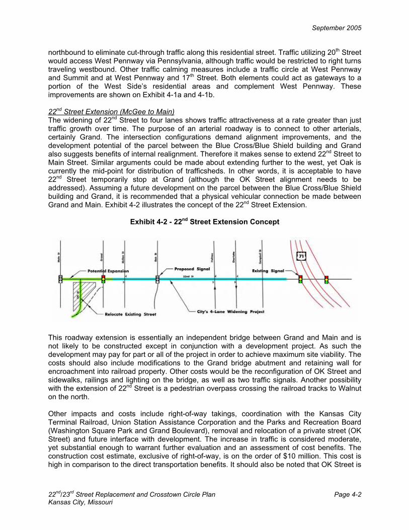
September 2005
22nd
/23rd
Street Replacement and Crosstown Circle Plan Page 4-2 Kansas City, Missouri
northbound to eliminate cut-through traffic along this residential street. Traffic utilizing 20th Street would access West Pennway via Pennsylvania, although traffic would be restricted to right turns traveling westbound. Other traffic calming measures include a traffic circle at West Pennway and Summit and at West Pennway and 17th Street. Both elements could act as gateways to a portion of the West Side’s residential areas and complement West Pennway. These improvements are shown on Exhibit 4-1a and 4-1b.
22nd Street Extension (McGee to Main)The widening of 22nd Street to four lanes shows traffic attractiveness at a rate greater than just traffic growth over time. The purpose of an arterial roadway is to connect to other arterials, certainly Grand. The intersection configurations demand alignment improvements, and the development potential of the parcel between the Blue Cross/Blue Shield building and Grand also suggests benefits of internal realignment. Therefore it makes sense to extend 22nd Street to Main Street. Similar arguments could be made about extending further to the west, yet Oak is currently the mid-point for distribution of trafficsheds. In other words, it is acceptable to have 22nd Street temporarily stop at Grand (although the OK Street alignment needs to be addressed). Assuming a future development on the parcel between the Blue Cross/Blue Shield building and Grand, it is recommended that a physical vehicular connection be made between Grand and Main. Exhibit 4-2 illustrates the concept of the 22nd Street Extension.
Exhibit 4-2 - 22nd Street Extension Concept
This roadway extension is essentially an independent bridge between Grand and Main and is not likely to be constructed except in conjunction with a development project. As such the development may pay for part or all of the project in order to achieve maximum site viability. The costs should also include modifications to the Grand bridge abutment and retaining wall for encroachment into railroad property. Other costs would be the reconfiguration of OK Street and sidewalks, railings and lighting on the bridge, as well as two traffic signals. Another possibility with the extension of 22nd Street is a pedestrian overpass crossing the railroad tracks to Walnut on the north.
Other impacts and costs include right-of-way takings, coordination with the Kansas City Terminal Railroad, Union Station Assistance Corporation and the Parks and Recreation Board (Washington Square Park and Grand Boulevard), removal and relocation of a private street (OK Street) and future interface with development. The increase in traffic is considered moderate, yet substantial enough to warrant further evaluation and an assessment of cost benefits. The construction cost estimate, exclusive of right-of-way, is on the order of $10 million. This cost is high in comparison to the direct transportation benefits. It should also be noted that OK Street is

g:\K
C02
\029
5\P
lann
ing\
exhi
bit 4
-1a.
sht
10/10/05
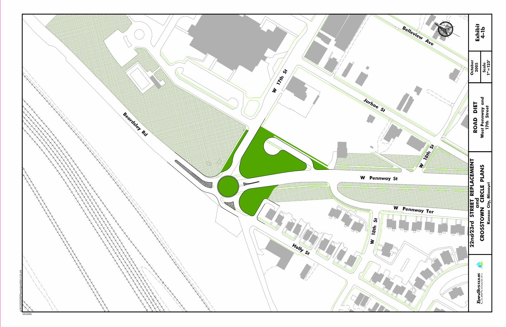
g:\K
C02
\029
5\P
lann
ing\
exhi
bit 4
-1b.
sht
10/10/05
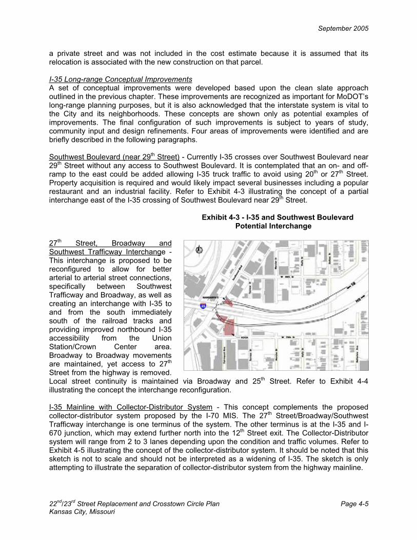
September 2005
22nd
/23rd
Street Replacement and Crosstown Circle Plan Page 4-5 Kansas City, Missouri
a private street and was not included in the cost estimate because it is assumed that its relocation is associated with the new construction on that parcel.
I-35 Long-range Conceptual ImprovementsA set of conceptual improvements were developed based upon the clean slate approach outlined in the previous chapter. These improvements are recognized as important for MoDOT’s long-range planning purposes, but it is also acknowledged that the interstate system is vital to the City and its neighborhoods. These concepts are shown only as potential examples of improvements. The final configuration of such improvements is subject to years of study, community input and design refinements. Four areas of improvements were identified and are briefly described in the following paragraphs.
Southwest Boulevard (near 29th Street) - Currently I-35 crosses over Southwest Boulevard near 29th Street without any access to Southwest Boulevard. It is contemplated that an on- and off-ramp to the east could be added allowing I-35 truck traffic to avoid using 20th or 27th Street. Property acquisition is required and would likely impact several businesses including a popular restaurant and an industrial facility. Refer to Exhibit 4-3 illustrating the concept of a partial interchange east of the I-35 crossing of Southwest Boulevard near 29th Street.
Exhibit 4-3 - I-35 and Southwest Boulevard Potential Interchange
27th Street, Broadway and Southwest Trafficway Interchange - This interchange is proposed to be reconfigured to allow for better arterial to arterial street connections, specifically between Southwest Trafficway and Broadway, as well as creating an interchange with I-35 to and from the south immediately south of the railroad tracks and providing improved northbound I-35 accessibility from the Union Station/Crown Center area. Broadway to Broadway movements are maintained, yet access to 27th
Street from the highway is removed. Local street continuity is maintained via Broadway and 25th Street. Refer to Exhibit 4-4 illustrating the concept the interchange reconfiguration.
I-35 Mainline with Collector-Distributor System - This concept complements the proposed collector-distributor system proposed by the I-70 MIS. The 27th Street/Broadway/Southwest Trafficway interchange is one terminus of the system. The other terminus is at the I-35 and I-670 junction, which may extend further north into the 12th Street exit. The Collector-Distributor system will range from 2 to 3 lanes depending upon the condition and traffic volumes. Refer to Exhibit 4-5 illustrating the concept of the collector-distributor system. It should be noted that this sketch is not to scale and should not be interpreted as a widening of I-35. The sketch is only attempting to illustrate the separation of collector-distributor system from the highway mainline.

September 2005
22nd
/23rd
Street Replacement and Crosstown Circle Plan Page 4-6 Kansas City, Missouri
Exhibit 4-6 I-670 Walnut/Grand Interchange Concept
Exhibit 4-4 I-35 and Southwest Trafficway and Broadway
Interchange Concept
Exhibit 4-5 I-35 Collector-Distributor
Concept
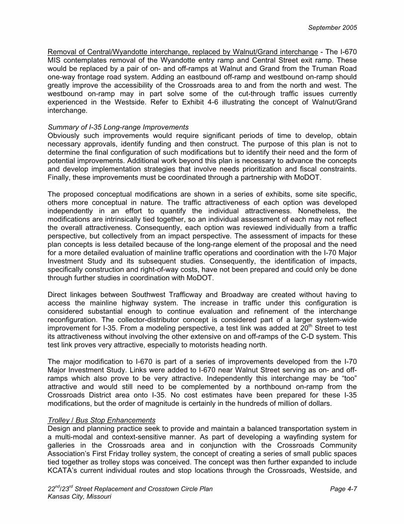
September 2005
22nd
/23rd
Street Replacement and Crosstown Circle Plan Page 4-7 Kansas City, Missouri
Removal of Central/Wyandotte interchange, replaced by Walnut/Grand interchange - The I-670 MIS contemplates removal of the Wyandotte entry ramp and Central Street exit ramp. These would be replaced by a pair of on- and off-ramps at Walnut and Grand from the Truman Road one-way frontage road system. Adding an eastbound off-ramp and westbound on-ramp should greatly improve the accessibility of the Crossroads area to and from the north and west. The westbound on-ramp may in part solve some of the cut-through traffic issues currently experienced in the Westside. Refer to Exhibit 4-6 illustrating the concept of Walnut/Grand interchange.
Summary of I-35 Long-range Improvements Obviously such improvements would require significant periods of time to develop, obtain necessary approvals, identify funding and then construct. The purpose of this plan is not to determine the final configuration of such modifications but to identify their need and the form of potential improvements. Additional work beyond this plan is necessary to advance the concepts and develop implementation strategies that involve needs prioritization and fiscal constraints. Finally, these improvements must be coordinated through a partnership with MoDOT.
The proposed conceptual modifications are shown in a series of exhibits, some site specific, others more conceptual in nature. The traffic attractiveness of each option was developed independently in an effort to quantify the individual attractiveness. Nonetheless, the modifications are intrinsically tied together, so an individual assessment of each may not reflect the overall attractiveness. Consequently, each option was reviewed individually from a traffic perspective, but collectively from an impact perspective. The assessment of impacts for these plan concepts is less detailed because of the long-range element of the proposal and the need for a more detailed evaluation of mainline traffic operations and coordination with the I-70 Major Investment Study and its subsequent studies. Consequently, the identification of impacts, specifically construction and right-of-way costs, have not been prepared and could only be done through further studies in coordination with MoDOT.
Direct linkages between Southwest Trafficway and Broadway are created without having to access the mainline highway system. The increase in traffic under this configuration is considered substantial enough to continue evaluation and refinement of the interchange reconfiguration. The collector-distributor concept is considered part of a larger system-wide improvement for I-35. From a modeling perspective, a test link was added at 20th Street to test its attractiveness without involving the other extensive on and off-ramps of the C-D system. This test link proves very attractive, especially to motorists heading north.
The major modification to I-670 is part of a series of improvements developed from the I-70 Major Investment Study. Links were added to I-670 near Walnut Street serving as on- and off-ramps which also prove to be very attractive. Independently this interchange may be “too” attractive and would still need to be complemented by a northbound on-ramp from the Crossroads District area onto I-35. No cost estimates have been prepared for these I-35 modifications, but the order of magnitude is certainly in the hundreds of million of dollars.
Trolley / Bus Stop EnhancementsDesign and planning practice seek to provide and maintain a balanced transportation system in a multi-modal and context-sensitive manner. As part of developing a wayfinding system for galleries in the Crossroads area and in conjunction with the Crossroads Community Association’s First Friday trolley system, the concept of creating a series of small public spaces tied together as trolley stops was conceived. The concept was then further expanded to include KCATA’s current individual routes and stop locations through the Crossroads, Westside, and

September 2005
22nd
/23rd
Street Replacement and Crosstown Circle Plan Page 4-8 Kansas City, Missouri
Jazz District to create enhancements that could be used every day, not just for the First Friday events. These trolley/bus stop enhancements could include larger waiting areas and site amenities of benches, trash receptacles, kiosks and improved lighting. Exhibit 4-7a shows the existing First Friday trolley route. Exhibit 4-7b shows a potential re-routing that would be integrated with several of the other transportation, streetscape and open-space improvements recommended as part of this plan.
Exhibit 4-7a – First Friday Trolley Route Exhibit 4-7b – Potential Re-routing
Streetscape Improvement ZonesThe three elements that define the urban design framework include pocket parks, street functionality, and streetscape enhancements. Working together, these three elements define public spaces and connections within the Crossroads and between the Jazz District and Westside. The public open-spaces are defined by their environment and promote a variety of community activities including art displays, concerts, readings and recreation. The pocket parks would serve as distinct identifiers yet each would be a unique space responding to the differing environments. They could be passive or active depending upon their location. Locations of these potential pocket parks, linked by streetscape enhancements, are shown in Exhibit 4-8.
Within the Crossroads there are numerous pieces of private property that could be candidates for some type of small green space. There are existing underutilized properties and parking lots, on which a small piece could be dedicated to open space. Future parking lots could have dedicated park space.

September 2005
22nd
/23rd
Street Replacement and Crosstown Circle Plan Page 4-9 Kansas City, Missouri
Exhibit 4-8 - Pocket Park Locations and Streetscape Corridors
Preliminary standards have been developed for each of the streetscape improvement zones described below and are listed in Exhibit 4-9. Exhibit 4-10 illustrates a sample streetscape section.
Exhibit 4-9 - Streetscape Improvement Guidelines
Standard
Zone Type Transportation
ArteryPedestrian Way
Pedestrian (x2) 8 – 10’ 8 – 10’ Amenity(x2) 0 – 10’ 5 – 10’
Parking 7 – 20’ 7 – 20’ Traffic 36 – 60’ 24 – 48’
Gathering 0 – 15’ 5 – 20’
A: Pedestrian Zone - The pedestrian zone is the focus of streets designated as pedestrian ways. The pedestrian zone should be of a comfortable width to allow pedestrians to move along the block. This zone should provide connections along all blocks with very little interruption. Generally, the pedestrian zone would be unencumbered with objects however, small signs would be allowed. Pavement, such as brick, stone or textured materials, that sets the pedestrian zone apart from adjacent zones is encouraged. An example of the pedestrian zone concept is shown in Exhibit 4-10 along Baltimore.

September 2005
22nd
/23rd
Street Replacement and Crosstown Circle Plan Page 4-10 Kansas City, Missouri
Exhibit 4-10 - Pedestrian Zone Example
B: Amenity Zone - The amenity zone is intended to accomplish several things with regard to streetscape and connections. This zone is where the street amenities such as street furniture, trees, planters, trash receptacles, transit shelters, lighting and other embellishments will go. The amenity area should always be immediately adjacent to the pedestrian zone. This zone is not intended to move pedestrians but to provide a comfortable environment for pedestrians to interact. It is intended to provide an area or barrier between vehicles and pedestrians. (In some instances where the right-of-way is very limited, parallel parking could be used in this zone.) Therefore, the amenity area should most often be located between the parking or traffic zones and the pedestrian zones, unless another way to buffer the pedestrians is found.
C: Parking Zone - The parking zone is intended to accommodate on-street parking to serve the businesses and residential development. Like the rest of the zones, the design of on-street parking should be tailored to the street on which it is being implemented. On-street parking alternatives include parallel, angle and 90-degree parking. One issue is the ability to count on-street parking toward required totals for development. The provision of additional, generally available on-street parking within the existing rights-of-way is a challenge and will be more so with the desire of each property owner to count spaces as required parking.
D: Traffic Zone - The traffic zone consists of the lanes of traffic that are provided on a given street. Similar to the other zones, the traffic zone will vary in size depending on the functional hierarchy of the street. Generally, it is proposed that pedestrian ways will have smaller traffic zones than transportation arteries. Additionally, traffic zones within pedestrian ways should be buffered by parking zones to further enhance the pedestrian comfort level within those streets. The width of traffic lanes should be flexible to accommodate a scaling of all zones to provide the appropriate street atmosphere.
E: Gathering Zone - The gathering zone is an additional area to provide pedestrian amenities within the right-of-way section. It is foreseen that these areas will complement the amenity zone and provide larger areas for pedestrians to congregate. These areas may be used privately, such as a restaurant patio, or publicly, such as art exhibition space, depending on the location and space available. The gathering zone should be considered an additional amenity to enhance the linkages between areas and provide smaller interim spaces for people. Items that could be found within this zone include additional street furniture and landscaping, as well as dining areas, art exhibit space, natural areas, and outdoor shopping space to support retail

September 2005
22nd
/23rd
Street Replacement and Crosstown Circle Plan Page 4-11 Kansas City, Missouri
establishments. Gathering zones will be primarily found on pedestrian ways. An example of a gathering zone is shown in Exhibit 4-11 along 19th Street between Baltimore and Main.
Exhibit 4-11 - Gathering Zone Example
Road DietsFor the streets undergoing a road diet, there are essentially two issues: traffic capacity defined by the signalized intersections and treatment of on-street parking. Capacity analysis under the future year peak hour indicates that acceptable levels of service would be provided for 18th
Street with one lane in each direction, 19th Street with a three-lane cross section and Baltimore with one-lane in each direction. The existing and proposed cross sections for these streets are shown embedded in the road diet plan sheets for 18th, 19th, Baltimore and 20th Streets. These road diet plan sheets are shown in Exhibits 4-12a through 4-12d for 18th and 19th Streets, Exhibits 4-13a and 4-13b for Baltimore and Exhibits 4-14a and 4-14b for 20th Street. A plate index of all exhibits is shown in Exhibit 4-15.
The treatment of on-street parking must be considered. Angle parking is proposed along many of the road diet streets. In other cases parallel parking restrictions during peak hours are proposed to be removed. It should be noted that while many of the concept plans show parking spaces, this is done for illustrative purposes only. The location of driveways, loading zones, fire hydrants, bus stops, and other features will determine the extent and number of on-street parking spaces. The intent is to demonstrate that on-street parking can be provided with the identified improvements. Independent of the type of parking, the traffic assessment indicates that a reduced number of lanes would still provide adequate levels of service.

September 2005
22nd
/23rd
Street Replacement and Crosstown Circle Plan Page 4-12 Kansas City, Missouri
It has been determined that all of the road diet concepts pass the tests of being physically and operationally viable. In terms of cost to implement, the extent of the cost is dependent upon the type of streetscape features. Several categories were devised to develop costs, including roadway modifications, removal of existing medians, traffic signal modifications, intersection sidewalk treatments, sidewalk modifications (based upon conditions of sidewalk) and streetscape including sidewalk accents, street furniture and landscaping.
The capacity analysis along 20th Street at key intersections indicates that the five lane section would provide acceptable levels of service. The exclusive left turn lanes are proposed with protected/permitted phasing. Exclusive right turn lanes are proposed in the eastbound travel direction at Grand. To facilitate pedestrian crossings, on 20th Street portions of the center turn lane may allow for construction of a median refuge island, particularly between Wyandotte and Baltimore.
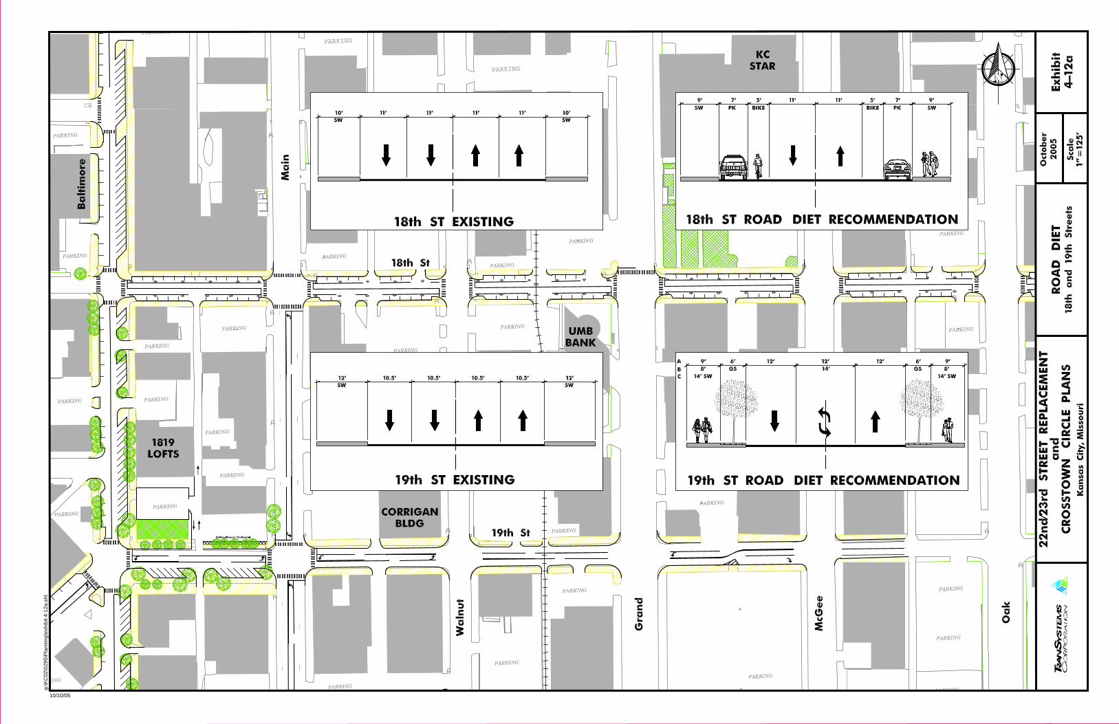
CB
PARKING
PARKING
PARKING
g:\K
C02
\029
5\P
lann
ing\
exhi
bit 4
-12a
.sht
10/10/05
COPYRIGHT 2000 - FIREHOUSE DESIGNS
COPYRIGHT 1999 FIREHOUSE DESIGNS
COPY
RIGHT 1999
-
FIREHO
USE DE
SIGN
S
COPY
RIGH
T 19
99 - FIREHO
USE
DESI
GNS
COPYRIGHT 2000 - FIREHOUSE DESIGNS
COPYRIGHT 2000 - FIREHOUSE DESIGNS
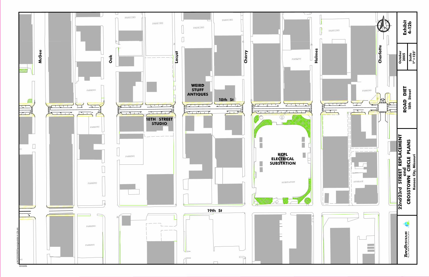
PARKING
PARKING
PARKING
PARKING
PARKINGg:
\KC
02\0
295\
Pla
nnin
g\ex
hibi
t 4-1
2b.s
ht
10/10/05

PARKINGg:
\KC
02\0
295\
Pla
nnin
g\ex
hibi
t 4-1
2c.s
ht
10/10/05
PARKING
g:\K
C02
\029
5\P
lann
ing\
exhi
bit 4
-12d
.sht
10/10/05

CB
CB
CB
CB
CB
CB
CB
PARKING
PARKING
PARKING
PARKING
PARKING
PARKING
PARKING
PARKING
g:\K
C02
\029
5\P
lann
ing\
exhi
bit 4
-13a
.sht
10/10/05CO
PYRI
GHT 19
99
- FIRE
HOUSE
DESI
GNS
COPY
RIGH
T 19
99
- FI
REHO
USE DESIGNS
COPY
RIGH
T 19
99
- FI
REHOUS
E DESIGN
S
COPYRI
GHT 19
99 -
FIREHO
USE
DESI
GNS
COPYRIGHT 2000 - FIREHOUSE DESIGNS COPYRIGHT 2000 - FIREHOUSE DESIGNS

ASPH
ASPH
ASPH
ASPH
CB
CB
CB
CB
CBCB
CB
DI
DIDI
DI
DI
DI
DI
DI
CB
PARKING
PARKING
PARKING
PARKING
PARKING
PARKING
PARKING
PARKING
PARKING
PARKING
PARKING
PARKING
PARKING
PARKING
PARKING
g:\K
C02
\029
5\P
lann
ing\
exhi
bit 4
-13b
.sht
10/10/05

g:\K
C02
\029
5\P
lann
ing\
exhi
bit 4
-14a
.sht
10/10/05

COPY
RIGHT
1999
- FIRE
HOUSE DESIGN
S
COPYRIGHT 2000 - FIREHOUSE DESIGNS
g:\K
C02
\029
5\P
lann
ing\
exhi
bit 4
-14b
.sht
10/10/05
ASPH
ASPH
ASPH
ASPH
ASPH
ASPH
ASPH
ASPH
ASPH
DIDI
DI
CB
CB
CB CBCB
CB CB
CB CB
CB CB
CBCB
CB
DI
DIDI
DI
CCB
C
DI
DIDI
DI
DIDI
DI
DIDI
DI
DI
DIDI
DI
DI
DI
DI
DIDI DI
DI DIDIDI
DI
DIDI
DI
DI
DI
DI
DI
OVERHEADSIGN
SIGN
OVERHEAD
DIDI
DIDI
PARKING
CB
DI
CB
DI
PARKING
PARKING
PARKING
PARKING
PARKING
PARKING
PARKING
TANK
TANK
TANKS
CB
PARKING
PARKING
PARKING
PARKING
PARKING
PARKING
PARKING
PARKING
PARKING
PARKING
PARKING
PARKING
PARKING
PARKING
PARKING
PARKING
PARKING
PARKING
PARKING
PARKING
PARKING
DI
PARKING
PARKINGPARKING
PARKING
PARKING GARAGE
PARKING
PARKING
PARKING
PARKING
PARKING PARKING
PARKING
PARKINGPARKING
PARKING
PARKING
PARKING
PARKING
PARKING
PARKING
PARKING
PARKING
PARKING PARKING
PARKING
PARKING
PARKING
PARKING
PARKING
PARKING
PARKING
PARKING
PARKING
PARKING
PARKING
PARKING
PARKING
PARKING
PARKING
PARKING
PARKING
PARKING
PARKING
PARKING
PARKING
PARKING
PARKING
PARKING
PARKINGPARKING
PARKING
PARKING
PARKING
PARKING
PARKING
PARKING
PARKING
PARKING
PARKINGPARKING
PARKING
PARKING
PARKINGPARKING
PARKING
PARKING
PARKING
PARKING
PARKING
PARKING
PARKING
PARKINGPARKING
PARKING
PARKING
PARKING
PARK
PARKING
PARKING
PARKING
PARKING
1066000N
2771000E
PARKING
PARKING
PARKING
PARKING LOT
g:\K
C02
\029
5\P
lann
ing\
20lo
cmap
.sht
10/10/05

September 2005
22nd
/23rd
Street Replacement and Crosstown Circle Plan Page 4-22 Kansas City, Missouri
Community Input The development of the preferred plan is a process that is in many ways iterative as it seeks input and guidance, incorporates that input and goes through further refinement from other interested parties. The community input has been used to help define the elements necessary for implementation as well as certain priority areas. Furthermore the input on the strategies allows for an initial definition of short-term, mid-term and long-term improvements.
As part of the continued evaluation and refinement, a series of community meetings were held during the month of October 2004. These included presentations to nearly 80 people from the Westside, the Downtown Council, the PIAC and the Jazz District. These meetings informed residents, businesses and other stakeholders about the plan, its objectives and current status. Questions were answered, and requests for further input were received. A couple of Steering Committee members were in attendance at these meetings. A set of displays was used to present summary material from the Working Papers and Technical Memoranda.
The following highlights some of the comments and issues raised at the various meetings. The presentations focused upon the dual nature of the plan to address both east-west transportation and the urban design element of public open space. The transportation strategies focused upon the needs-based assessment, the interrelationship of the road diet concepts with enhanced streetscapes, and long-range planning.
Westside – Posada del Sol - The general reaction expressed was concern regarding potential impacts to private property on the Westside, especially from proposed arterial improvements to West Pennway at its junction with Interstate 35, and the interpreted widening of I-35 associated with the long-range planning concepts. The concept of the road diet (changes made to the roadway within public right-of-way typically without taking private property) was viewed skeptically and several requests were made to see the plans of “houses with red x’s on them”. It was emphasized that the long-range planning concepts were just concepts and would not be further developed under this study.
Public Improvement Advisory Committee (PIAC) - The City Planning and Development Department staff made a brief presentation to the PIAC describing the Corridor Plan connecting the Westside to the Jazz District through the Crossroads and its transportation and urban design and place-making components. PIAC is charged with selecting projects to receive city sales tax funds. Citywide PIAC funds of $500,000 per year over 5 years were requested to assist in paying for infrastructure identified in this Plan. Initially the funds would be spent on detailed design and construction documents, and possibly for prototype areas that would implement both the transportation and urban design improvements envisioned by this Plan.
Downtown Council Transportation and Parking Committee - The Downtown Council Transportation and Parking Committee received the status report and, after emphasizing the need to integrate streetscape and urban design elements into previously presented plans, acknowledged the intent to enhance the pedestrian qualities and street environment. A question was raised about the review of angle parking by the City’s Public Works Department.
Jazz District Compact - The compact was especially interested in potential improvements to the East Side along the 18th Street corridor. Their questions centered on developing an implementation plan that identified priorities and phasing. Discussion included potential improvements to the intersection of the Paseo and 18th Street as a major gateway to the Jazz District, as well as sidewalk and streetscape improvements near Troost with its heavy pedestrian crossings between bus stops and local industries.

September 2005
22nd
/23rd
Street Replacement and Crosstown Circle Plan Page 4-23 Kansas City, Missouri
As part of continued coordination on transportation issues with the Crossroad Community Association’s Infrastructure Committee, members of the City and Consultant staff participated in a discussion concerning the dimensions of angle parking. This Plan and another independently prepared parking concept for the Crossroads area are proposing that a portion of Baltimore from Truman Road to 20th Street undergo a “road diet” where the number of lanes is reduced from four to two-lanes. A review of projected traffic volumes and operations at the signalized intersection of Baltimore and 18th Street indicate acceptable operations with a reduced number of lanes. Parallel parking, currently on both sides of the street, would be modified under this Plan with angle parking on one side of the street. Another concept developed by the Urban Society and supported by the Crossroads Community Association has proposed angle parking on both sides of the street. Both concepts would minimize the cost of implementation by keeping the changes between the existing curb lines.
Throughout Kansas City there are numerous examples of angle and parallel parking coexisting on the same street. Three examples include Walnut within the City Market, 63rd Street in Brookside and along Southwest Boulevard on the Westside. The dimensions of these existing facilities are shown in Exhibit 4-16.
Exhibit 4-16 - Examples of Angle and Parallel Parking
The dimensions of the roadway right-of-way, consisting of sidewalk, parking and travel lanes, must be balanced to accommodate various mobility needs. Typically the adjacent travel lane width next to angle parking is wider than a standard lane width (12 feet) to allow increased flexibility in exiting a parking space. In urban areas, narrow lane widths are prevalent. In the case of Baltimore, where the right-of-way is wide, narrow travel lane widths for a two-lane roadway are not necessary. City standards for 45 degree angle parking call for a minimum perpendicular width of 18.7 feet. Even with longer parking stalls, some vehicles could stick out into the travel way.
By utilizing the accepted City parking dimensions and staying within the existing curb lines, only one side of parking can be converted to angle parking, which side of Baltimore would have

September 2005
22nd
/23rd
Street Replacement and Crosstown Circle Plan Page 4-24 Kansas City, Missouri
angle parking and which side would have parallel parking was not determined. A practical issue associated with making such a change to parking is that City procedures require that 75% of the property owners along the affected stretch of roadway agree in writing to the change.
Essentially the community input has accepted and endorsed the road diet concept, with certain modifications and refinements to the initial layouts. This process is necessary and natural as the concept becomes “more real”. The added benefit of the road diet is that it can incorporate further concepts of place-making within the existing corridor such as pocket parks. One portion of a previous potential pocket park that is not within the existing right-of-way is associated with a gateway concept initially referred to as the “bowtie” at the junction of Southwest Boulevard and 20th Street. The triangular parcel on the southwest corner is currently a parking lot for a restaurant on the other side of Southwest Boulevard. This Plan respects this private parking area and only proposes to enhance the surrounding sidewalk within the public right-of-way.
Other input included negative reaction to certain restrictive access control measures limiting turn movements and introduction of one-way streets associated with the short-term improvements at the I-35 and West Pennway/Southwest Boulevard intersection complex. These restrictions were initially included to help define and facilitate the main traffic movements, but after further review it is acknowledged that less restrictive controls would not detrimentally affect traffic operations. Consequently, many of the initially restricted movements have been reinstated.
An initial concept involved the use of a roundabout at the junction of West Pennway and Summit Street to help calm traffic in the area and serve as a gateway to the Westside. Recent improvements such as the construction of the Heritage Trail and a proposed bus stop on a triangular parcel in the northwest quadrant between West Pennway and Summit has resulted in further refinement to the layout of the roundabout at this five-legged junction.
Politically, many of the concepts developed and presented were acceptable to the community in part because the process utilized the guiding principles to develop basic strategies and then specific solutions. All of the concepts have passed the physical feasibility test, but for certain roadway segments another test is necessary to determine whether or not the proposed improvement creates a better transportation environment. Then the last test of financial feasibility can be conducted to determine if the traffic attractiveness is not outweighed by the cost. Consequently, the concepts have been evaluated with various travel demand model runs from the projected base case including the 22nd Street extension and various Interstate 35 modifications.
However, this typical evaluation encounters an issue with a multi-modal analysis. The road diet concepts often provide benefits for non-motorized traffic and in many cases the attractiveness to motorized traffic is reduced. This typical evaluation must be considered in the context of the specific option and in the case of the road diet an assessment of future levels of service with a reduced number of lanes.

September 2005
22nd
/23rd
Street Replacement and Crosstown Circle Plan Page 4-25 Kansas City, Missouri
INITIAL PROJECTS
Essentially the community input has endorsed the road diet concept, with certain refinements to the initial layouts that were presented. The road diet theme can also incorporate the concept of enhanced bus and trolley stops. The road diet theme satisfies many of the initial tests in the ability to implement projects. First, the right-of-way is typically available since the concepts work within existing public streets. Second, the costs are typically manageable since they can be implemented over time. And third, the concepts can be coordinated and integrated with the place-making and streetscape elements.
Consequently an initial set of demonstration projects has been identified for each of the neighborhoods, the Westside, the Crossroads and the Jazz District.
Westside RoundaboutThe Westside intersection is proposed to be defined by a landscaped roundabout at the junction of West Pennway and Summit. See Exhibit 4-17. The roundabout would serve several functions including to slow traffic speeds and to establish a gateway at this community-facility junction with the Cabot Center, the Aguirre Center and the Westside Library. The roundabout could also be integrated with the recent construction of the Heritage Trail and KCATA bus shelter improvements.
The cost of this improvement is estimated at $312,500 for basic physical construction, including grading and possible retaining walls. Additional money is needed for survey, design, and construction inspection services.
Opinion of Probable Costs Westside Roundabout
Pavement Removal ..........................................................................................$25,000 Pavement Installation (asphalt)................................................................................ $85,000 Curbing and Concrete Sidewalks............................................................................. $80,000 Landscaping .......................................................................................... $35,000 Enhancement Amenities $25,000 SubTotal $250,000 Design Contingency (25%) $62,500 TOTAL $312,500

September 2005
22nd
/23rd
Street Replacement and Crosstown Circle Plan Page 4-26 Kansas City, Missouri
Exhibit 4-17 - Westside Roundabout Plan and Perspective

September 2005
22nd
/23rd
Street Replacement and Crosstown Circle Plan Page 4-27 Kansas City, Missouri
Crossroads CenterThe demonstration project chosen for the Crossroads is the mid-block area along 19th Street between Baltimore and Main. This project will introduce the road diet theme along 19th Street, reducing the current four-lane roadway to three lanes, bringing angle parking to this specific mid-block area and installing pedestrian crossing enhancements. Depending upon the desired extent of streetscape improvements, special paving patterns could be introduced to a reconstructed concrete roadway. The already wide sidewalks on the south side of 19th Street would be further enhanced (while retaining the glass block over the light wells) with such potential street furniture as bollards, planters, an information kiosk, bicycle racks, trash receptacles, and signature light fixtures. The specific design and style of these elements would be determined with Crossroads and neighborhood input during the design phase. See Exhibit 4-18.
This initial improvement is envisioned as a center point for other corridor streetscape improvements. It is proposed to include initial pavement marking changes along 19th Street from east of Main to McGee. Over time, preferably through an annual sidewalk improvement and streetscape enhancement program, the sidewalks of these blocks along 19th Street can be improved.
The cost of this improvement is estimated between $500,000 and $675,000 for basic physical construction.
Opinion of Probable Costs Crossroads Center
Pavement Removal ..........................................................................................$30,000 Curbing and Concrete Sidewalks........................................................................... $100,000 Landscaping .......................................................................................... $80,000 Pedestrian-scale light fixtures ................................................................................ $100,000 Enhancement Amenities $90,000 SubTotal $400,000 Design Contingency (25%) $100,000 TOTAL $500,000
Pavement Removal ..........................................................................................$30,000 Pavement Installation (concrete) optional................................................................$85,000 Curbing and Concrete Sidewalks............................................................................. $80,000 Landscaping ........................................................................................ $120,000 Pedestrian-scale light fixtures ................................................................................ $100,000 Enhancement Amenities $125,000 SubTotal $540,000 Design Contingency (25%) $135,000 TOTAL $675,000

September 2005
22nd
/23rd
Street Replacement and Crosstown Circle Plan Page 4-28 Kansas City, Missouri
Exhibit 4-18 - Crossroads Center Plan and Perspective.

September 2005
22nd
/23rd
Street Replacement and Crosstown Circle Plan Page 4-29 Kansas City, Missouri
18th and PaseoThe demonstration project chosen for the Jazz District is the intersection of 18th Street and Paseo. This location was chosen to help anchor the East Side element of the Plan, to act as a gateway to the Jazz District, to continue the road diet and enhancement themes already in the corridor, and to reinforce the YMCA redevelopment occurring in the southwest quadrant of this intersection. The basic limits of the demonstration area are at the intersection itself and include removal of the channelized southbound right-turn lane from Paseo to 18th Street. The road diet theme will also assist in making the transportation transition from six-lanes on Paseo (north of 18th Street) to four-lanes (south of 19th Street). The conversion to a five-lane section envisions providing on-street parking throughout the day. Currently on-street parking is restricted by direction of travel during the peak hour. See Exhibit 4-19.
The cost of this improvement is estimated at $612,500 for basic physical construction.
Opinion of Probable Costs 18th and Paseo
Pavement Removal ..........................................................................................$40,000 Pavement Installation (asphalt)................................................................................ $80,000 Curbing and Concrete Sidewalks........................................................................... $100,000 Pavers (optional) .......................................................................................... $75,000 Landscaping .......................................................................................... $40,000 Pedestrian-scale light fixtures .................................................................................. $80,000 Enhancement Amenities (monument) $75,000 SubTotal $490,000 Design Contingency (25%) $122,500 TOTAL $612,500
September 2005
22nd
/23rd
Street Replacement and Crosstown Circle Plan Page 4-30 Kansas City, Missouri
Exhibit 4-19 - 18th and Paseo Plan and Perspective

September 2005
22nd
/23rd
Street Replacement and Crosstown Circle Plan Page 4-31 Kansas City, Missouri
Other Priorities
One issue in identifying the priorities for projects is defining appropriate construction limits. For example, along Baltimore the on-street parking changes would need to be implemented from beginning to end (16th to 20th Street) and cannot be introduced block by block. Nonetheless, the change from four-lanes to two-lanes and the introduction of angle parking can be accomplished at a most basic level with merely pavement markings. Changes by pavement markings could also be accomplished for significant portions of 18th and 19th Streets. On other corridors, changes that include the removal of a median along 20th Street require physical construction.
The evaluation of the 22nd Street Extension from McGee to Main was determined to be dependent upon the development of the parcel bounded by the roadway and as such its timing is dependent upon the development. Consequently, while the extension is feasible and makes sense, it is not seen as necessary and a direct part of the public plan for this area.
The Interstate 35 improvements are by definition in the hands of the Missouri Department of Transportation. While extensive planning efforts are currently underway to address access issues in and around the Downtown Loop, the relatively short stretch of I-35 from the Downtown Loop to the State Line has essentially been overlooked. It is not the intent of this Plan to perform a MIS-like study, but the Plan can and does recognize that improvements are necessary from a transportation system point of view. Consequently, the initial concepts for such improvements are seen as part of the Plan, but further development and evaluation are not.
Priorities for improvements have been organized around time periods, such as short-term, mid-term and long-term. These suggested timing priorities are shown graphically in Exhibit 4-20. Road diets could be implemented fairly quickly and with modest capital investment. Consequently, it is suggested that the road diets become the first projects while the process of making needs-based improvements starts and progresses through its design process.
Projects identified for short-term implementation would essentially be spin-offs from the three initial projects. These short-term projects would include improvements to:
Baltimore, between 16th and 20th Streets
18th Street, between Baltimore and McGee
18th Street, between Charlotte and Troost
19th Street, between Main and McGee
West Pennway, between I-35 and Southwest Boulevard
The mid-term improvements would consist of constructing the needs-based improvements while continuing to implement in an incremental manner the road-diet and streetscape enhancement improvements. These mid-term projects would include improvements to:
Southwest Boulevard, between Broadway and Baltimore
18th Street, between McGee and Charlotte
18th Street, between Troost and Paseo
20th Street, between Southwest Boulevard and Mc Gee
September 2005
22nd
/23rd
Street Replacement and Crosstown Circle Plan Page 4-32 Kansas City, Missouri
Exhibit 4-20 - Suggested Priorities
Long-term improvements involve any modifications to the Interstate system. In order to determine and develop such modifications, a planning process must begin to work with the neighborhoods and other parties to develop appropriate solutions. The long-term projects could include improvements to:
The existing I-35 Interchange with Broadway and Southwest Trafficway
A proposed I-35 Interchange with Southwest Boulevard
Modifications to the I-35 mainline from the State Line to the Downtown Loop
Implementation
This section focuses upon the procedural steps to carry the Plan forward. It also discusses some of the necessary elements such as community support and funding sources that would assist in making the Plan a reality in terms of the identified infrastructure improvements. Earlier sections on project prioritization can be integrated with the implementation as part of programming projects into a schedule and determining necessary funding levels.

September 2005
22nd
/23rd
Street Replacement and Crosstown Circle Plan Page 4-33 Kansas City, Missouri
Procedural Steps
Several different procedural avenues need to be followed through the City’s Departments including the Parks and Recreation Board.
Planning and Development Department - Informational meetings on the Plan and its recommendations are necessary for several committees of the City Council, including the Operations Committee and the Planning, Zoning and Economic Development Committee. After providing information to these committees, the Plan will be presented to the City Plan Commission for its action. The City Plan Commission is anticipated to adopt the Plan. While the Plan does not make any land use changes which require adoption, it is a comprehensive area-wide plan, in the tradition of FOCUS, that can be adopted.
Revisions to the City’s Major Street Plan may also be desired. In April 2001, the Major Street Plan was updated to remove the portion of 22nd Street between I-35 and Main Street. A reason for the development of this Plan was to review whether the section of 22nd Street between Main and Grand should remain on the Major Street Plan. This Plan identifies this section of roadway as necessary for development of the parcel between the Kansas City Terminal Railroad tracks, Washington Square Park and OK Street. Consequently, it is recommended that the piece of 22nd Street between Main and Grand remain on the City’s Major Street Plan.
Other sections of the Major Street Plan are not directly affected, although it could be suggested that 20th Street between Southwest Boulevard and Grand be added to the Major Street Plan as an arterial. It could also be suggested that the portion of 19th Street between Baltimore and Main be removed. The section of Baltimore, from 19th to Truman could also be removed, but for continuity reasons we have not recommended this because Baltimore crosses into the Downtown Loop whose area is beyond this study.
Parks and Recreation Board - This Board will receive a status report on the Plan at its regularly scheduled Development Review Committee. The emphasis will be placed on the Board’s boulevard system, specifically The Paseo and West Pennway. While some other roadways are called boulevards, such as Southwest Boulevard, they are technically not part of Park’s boulevard system.
Community SupportThe Plan includes the communities of the Westside, the Crossroads and the Jazz District. These three communities span two Council District boundaries. It has been recommended by the Steering Committee members that a specific organization be formed to represent the three communities in conjunction with the implementation of this Plan. It has been suggested that two representatives from an existing organization within each community be appointed to work jointly to create and sustain the necessary political interest to carry the recommendations of the Plan forward. The Steering Committee also recognizes that City staff assistance for such an organizational entity is critical for the organization to stay informed and aware of the necessary City procedures and available opportunities.
Financial ConsiderationsThe Plan has identified several miles of potential improvements. Some improvements could be initially implemented with only pavement markings. Other improvements, such as streetscape enhancements, may be best determined through the design process. Nonetheless, these improvements will require substantial funds to implement. The Public Improvements Advisory Committee would be an important source of such funding. Other local financial incentives would

September 2005
22nd
/23rd
Street Replacement and Crosstown Circle Plan Page 4-34 Kansas City, Missouri
include a matching grant rebate, similar to a façade rebate program. Another possibility would be the formation of a special improvement district, such as a community improvement district (CID) or transportation development district (TDD).