2015 Village of Agua Fria Community Plan Update I. Village ... Village of Agua Fria... · The...
6
1 2015 Village of Agua Fria Community Plan Update I. Village of Agua Fria Community Plan Purpose The Village of Agua Fria (VAF) Community Plan was adopted by Resolution 2006-116. The Resolution to adopt the plan recognized the Planning Committee concerns to preserve the community’s history by preserving the traditional growth patterns, to ensure appropriate management of the aquifer for residential wells, accommodating residential growth and affordable housing. The Village of Agua Fria Community Plan Purpose Statement is as follows: Our Vision for Agua Fria is a community where history has been embraced, where we value our cultural and historical origins while creating a sustainable and thriving future for our citizens. A community where our children have an opportunity to live and prosper. A community that welcomes and encourages children to become full participants of village life in a safe environment and where generations are still on their ancestors land; where young people think of staying. We resolve to protect the Santa Fe River and our open spaces as well as the unique character of our Village by honoring our cultures and the area’s historical, agricultural, livestock and residential traditions. We, as a community, further resolve to work together to preserve, maintain and accomplish our vision of a sustainable, well-planned community where people of all income levels are welcome and where people are able to live and work in harmony with their neighbors. The initial planning process brought the community together to discuss shared values and concerns so that the community can craft a plan that will guide future growth in the planning area . Plan implementation will guide the location and scale of commercial and residential development, public facilities and infrastructure, and protect the water supply, open vistas, and other natural resources. II. Village of Agua Fria Plan Update 1. Purpose: The Village of Agua Fria Community Plan was adopted in accordance with Santa Fe County’s Community Planning process and Ordinance 2002-3. The County subsequently adopted the Sustainable Growth Management Plan (SGMP) in 2010 and the Sustainable Land Development
-
Upload
phungkhuong -
Category
Documents
-
view
222 -
download
3
Transcript of 2015 Village of Agua Fria Community Plan Update I. Village ... Village of Agua Fria... · The...
1
2015 Village of Agua Fria Community Plan Update
I. Village of Agua Fria Community Plan Purpose
The Village of Agua Fria (VAF) Community Plan was adopted by Resolution 2006-116. The
Resolution to adopt the plan recognized the Planning Committee concerns to preserve the
community’s history by preserving the traditional growth patterns, to ensure appropriate
management of the aquifer for residential wells, accommodating residential growth and
affordable housing. The Village of Agua Fria Community Plan Purpose Statement is as follows:
Our Vision for Agua Fria is a community where history has been
embraced, where we value our cultural and historical origins while
creating a sustainable and thriving future for our citizens.
A community where our children have an opportunity to live and
prosper. A community that welcomes and encourages children to
become full participants of village life in a safe environment and where
generations are still on their ancestors land; where young people think
of staying.
We resolve to protect the Santa Fe River and our open spaces as well as
the unique character of our Village by honoring our cultures and the
area’s historical, agricultural, livestock and residential traditions.
We, as a community, further resolve to work together to preserve,
maintain and accomplish our vision of a sustainable, well-planned
community where people of all income levels are welcome and where
people are able to live and work in harmony with their neighbors.
The initial planning process brought the community together to discuss shared values and
concerns so that the community can craft a plan that will guide future growth in the planning
area . Plan implementation will guide the location and scale of commercial and residential
development, public facilities and infrastructure, and protect the water supply, open vistas, and
other natural resources.
II. Village of Agua Fria Plan Update
1. Purpose:
The Village of Agua Fria Community Plan was adopted in accordance with Santa Fe County’s
Community Planning process and Ordinance 2002-3. The County subsequently adopted the
Sustainable Growth Management Plan (SGMP) in 2010 and the Sustainable Land Development
2
Code (SLDC) in 2013. The SLDC indicates the purpose and intent for Community Plans as
follows:
The Community Plan is intended to identify development and growth impacts for an area
and provide strategies and land use recommendations including a future land use plan
consistent with the SGMP.
A Community Plan is intended to permit communities to recommend adoption of
particular land use regulations based on the needs and goals of the community and shall
conform to the procedures set forth in the SLDC, and to subsequently update plans as
necessary due to changing circumstances.
The initial VAF Community Planning area consisted of the Village of Agua Fria Traditional
Historic Community (THC). Following the adoption of the VAF Community Plan, the THC
boundary was amended. This boundary amendment left a portion of the VAF within the
Extraterritorial Zoning Area (EZ). The EZ was eventually repealed as a result of the City County
Annexation agreements. Thus, as the EZ no longer exists as a zoning area, there is a need for the
2015 Community Plan update to include this area in the land use plan.
The purpose for the 2015 VAF Community Plan Update is to provide an update to the existing
plan in order to ensure that the plan is consistent with the County’s adopted Sustainable Growth
Management Plan (SGMP) and to ensure that the plan is implemented through the Official
Zoning Map and Sustainable Land Development Code (SLDC). The SGMP framework includes
a Growth Management Strategy that includes a comprehensive zoning approach based on a land
use plan, a use matrix, notification procedures, community planning and public participation.
III. Transitional Overview
In January 2015, the Board established the Village of Agua Fria Planning Committee and
authorized it to develop a Community Plan Update, community district zoning and draft a
community district overlay for amendments to SGMP and SLDC. Provisions in the existing plan
that are inconsistent with the SGMP will be superseded through this plan update. Community
Plans and updates will be implemented through the establishment of an Overlay District in
Chapter 9 of the SLDC and through adoption of the base zoning districts through the Official
Zoning Map. The following sections of the existing VAF Plan will amend the SGMP:
1. Use Matrix
The Use Matrix and design standards in the existing VAF Plan will be superseded through the
Community District Overlay in the SLDC which has been drafted in accordance with the
Community Plan Update process.
2. Procedures
Procedures identified through the VAF Plan will be superseded by the policies and procedures
identified in the SGMP and the SLDC.
3
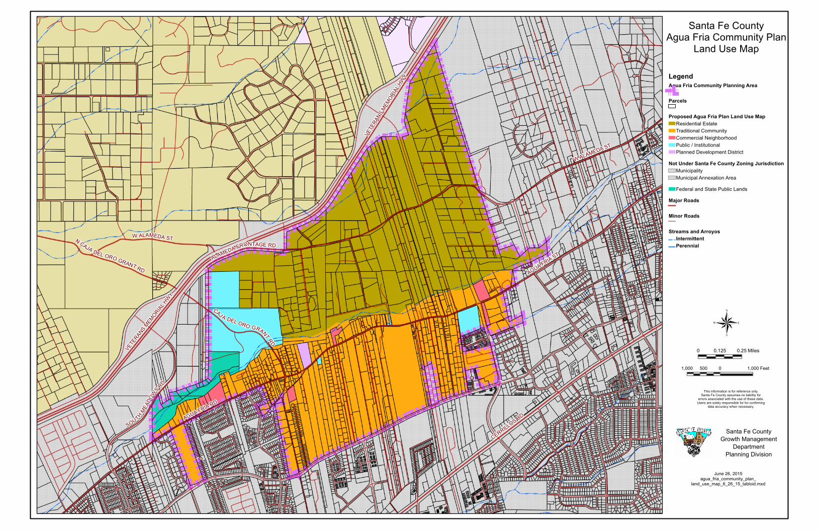
3. Land Use Plan Update
The Land Use Map reflects the proposed land use categories. Below is a breakdown of the two
distinct development areas in the VAF Planning Area.
Residential Estate. The purpose of this land use category is to designate areas suitable for a
combination of large-lot and suburban-type residential development, ranchettes and other
compatible uses. Residential Estate supports single-family homes on medium sized lots
consistent with the Village of Agua Fria’s development north of the Santa Fe River. This
category may include limited agricultural use accessory to residential uses. Density transfers and
clustered development should be allowed in order to support continued farming and/or ranching
activities, conserve open space or protect scenic features and environmentally sensitive areas.
Density can be increased in this area with having a shared well or community water.
Traditional Community. The purpose of this land use category is to designate areas suitable for
residential, small-scale commercial and traditional agricultural uses consistent with the existing
development patterns of traditional communities. The Traditional Community land use category
accommodates traditional community patterns, preserves historic and cultural landscapes, and
protects agricultural uses, including agriculture with acequia systems, from encroachment by
development. Potential for increased density within the district is available with community
water and sewer connections. Clustered development should be allowed in order to support
continued farming and/or ranching activities, conserve open space or protect scenic features and
environmentally sensitive areas.
Commercial Neighborhood. The purpose of this land use category is to allow for low-rise low-
intensity convenience retail and personal services, as well as office uses, which are intended to
serve and are in close proximity to individual residential neighborhoods. In the Village of Agua
Fria parcels designated Commercial Neighborhood have previously received Master Plan
approval for a commercial use on the property.
VAFCD Planned Development. Planned Development Districts are included as a land use
category in order to recognize existing Master Plan approvals for properties that do not fit a
single land use category. Properties in a PDD may be built out in accordance with their approved
master plans.
Public Institutional. The purpose of the Public Institutional category is to accommodate
governmental, educational and non-profit or institutional uses, including public or community
parks, recreation facilities and public, non-profit, and institutional residential uses, but excluding
any such uses of an extensive heavy industrial character. Development in this area should be
multi-use and designed with community input in order to meet community goals and objectives.
Federal and State public lands. The VAF planning area includes areas which are under the
ownership and jurisdiction of the State and Federal government. These areas are not subject to
local government zoning.
4
4. Land Use Map
The Land Use Map will be an amendment to the Future Land Use Map in the Sustainable
Growth Management Plan. The Land Use Map will provide a framework for the base zoning in
the Offical Map for the Village of Agua Fria Community District. The Land Use Map is
identified as Map 1.
Map 1: Village of Agua Fria Community Plan Land Use Map
AGUA FRIA RD
CERRILLOS RD
VETE
RANS
MEMORIA
L HWY
AGUA FRIA ST
W ALAMEDA ST
SOUTH MEADO
WS RD
N CAJA DEL ORO GRANT RD
CAJ A DEL ORO GRANT RD
ALAMEDA FRONTAGE RD
VETERANS MEMORIAL H
WYW ALAMEDA ST
Santa Fe CountyAgua Fria Community Plan
Land Use Map
LegendAgua Fria Community Planning Area
Parcels
Proposed Agua Fria Plan Land Use MapResidential EstateTraditional CommunityCommercial NeighborhoodPublic / InstitutionalPlanned Development District
Not Under Santa Fe County Zoning JurisdictionMunicipality Municipal Annexation AreaFederal and State Public Lands
Major Roads
Minor Roads
Streams and ArroyosIntermittentPerennial
®1,000 0 1,000500 Feet
June 26, 2015agua_fria_community_plan_
land_use_map_6_26_15_tabloid.mxd
This information is for reference only.Santa Fe County assumes no liability for
errors associated with the use of these data.Users are solely responsible for for confirming
data accuracy when necessary.
Santa Fe CountyGrowth Management
DepartmentPlanning Division
0 0.250.125 Miles
6
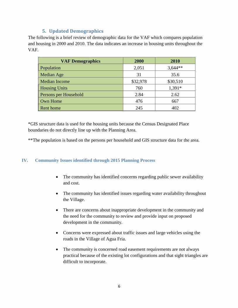
5. Updated Demographics The following is a brief review of demographic data for the VAF which compares population
and housing in 2000 and 2010. The data indicates an increase in housing units throughout the
VAF.
VAF Demographics 2000 2010
Population 2,051 3,644**
Median Age 31 35.6
Median Income $32,978 $30,510
Housing Units 760 1,391*
Persons per Household 2.84 2.62
Own Home 476 667
Rent home 245 402
*GIS structure data is used for the housing units because the Census Designated Place
boundaries do not directly line up with the Planning Area.
**The population is based on the persons per household and GIS structure data for the area.
IV. Community Issues identified through 2015 Planning Process
The community has identified concerns regarding public sewer availability
and cost.
The community has identified issues regarding water availability throughout
the Village.
There are concerns about inappropriate development in the community and
the need for the community to review and provide input on proposed
development in the community.
Concerns were expressed about traffic issues and large vehicles using the
roads in the Village of Agua Fria.
The community is concerned road easement requirements are not always
practical because of the existing lot configurations and that sight triangles are
difficult to incorporate.