2010 REGIONAL BIKE-PED PLAN - Benton-Franklin … REGIONAL BIKE-PED PLAN.pdf · through a grant...
199
2010 Regional Bicycle and Pedestrian Transportation Plan For Benton, Franklin and Walla Walla Counties and Tri-Cities Urban Area Benton-Franklin Council of Governments
Transcript of 2010 REGIONAL BIKE-PED PLAN - Benton-Franklin … REGIONAL BIKE-PED PLAN.pdf · through a grant...

2010 Regional Bicycle and Pedestrian Transportation Plan
For
Benton, Franklin and Walla Walla Counties
and
Tri-Cities Urban Area
Benton-Franklin Council of Governments

(This page intentionally left blank)

RREEGGIIOONNAALL
BBIICCYYCCLLEE AANNDD PPEEDDEESSTTRRIIAANN
TTRRAANNSSPPOORRTTAATTIIOONN PPLLAANN
ffoorr
BBeennttoonn,, FFrraannkklliinn aanndd WWaallllaa WWaallllaa CCoouunnttiieess
aanndd
TTrrii--CCiittiieess UUrrbbaann AArreeaa
BBeennttoonn--FFrraannkklliinn CCoouunncciill ooff GGoovveerrnnmmeennttss
OOccttoobbeerr 22001100

(This page intentionally left blank)

REGIONAL BICYCLE AND PEDESTRIAN TRANSPORTATION PLAN
for Benton, Franklin, and Walla Walla
Counties and
Tri‐Cities Urban Area Adopted: October 2010
Prepared by the
Benton‐Franklin Council of Governments P.O. Box 217
1622 Terminal Drive Richland, Washington 99352
The preparation of this document was aided by the Washington State Department of Transportation
through a grant from the U. S. Department of Transportation, Federal Highway Administration and Federal Transit Administration

(This page intentionally left blank)
2010 Regional Bicycle and Pedestrian Transportation Plan
Benton-Franklin Council of Governments 1
TABLE OF CONTENTS ACKNOWLEDGEMENTS ............................................................................................. 4 PREFACE .............................................................................................................. 6 INTRODUCTION ...................................................................................................... 7 CREDIBILITY AND INSTITUTIONALIZATION ................................................................... 15 TRANSPORTATION PLANNING/HEALTH AND FITNESS LINK ............................................... 18 DEVELOPMENT OF A BICYCLE & PEDESTRIAN FRIENDLY ENVIRONMENT .............................. 20
Land Use Changes ............................................................................................ 21 Transportation Network Improvements .................................................................. 21 Basic Assumptions ............................................................................................ 23
SAFETY .............................................................................................................. 25
Bicycle Safety Education and Enforcement .............................................................. 25 Student Pedestrian Safety .................................................................................. 29 Pedestrian Safety Education and Enforcement .......................................................... 31 Local Safety/Education Efforts ............................................................................ 34
PLANS, POLICIES, REGULATIONS, and PRACTICES .......................................................... 35
Regional Transportation Plan ................................................................................ 35 Local Comprehensive Plans, Polices, Regulations and Practices ..................................... 37
Benton County ................................................................................................ 37 Franklin County ............................................................................................... 56 Walla Walla County .......................................................................................... 69
State Laws and Policies ....................................................................................... 80
State Laws Regarding Bicyclists ............................................................................ 80 State Laws Regarding Pedestrians ......................................................................... 85 Growth Management Act .................................................................................... 89 State Policies Concerning Bicycling and Pedestrian Travel ........................................... 89
Bicycle and Pedestrian Collision Data ...................................................................... 93 OTHER PROJECTS ................................................................................................ 106
Sacagawea Heritage Trail .................................................................................. 106 Tapteal Greenway .......................................................................................... 110 Mill Creek Trail .............................................................................................. 112
BICYCLE – PEDESTRIAN WORKSHOPS ......................................................................... 114 PROPOSED PROJECTS ........................................................................................... 133 FUNDING SOURCES ............................................................................................... 137
Federal ....................................................................................................... 137 State .......................................................................................................... 137 Local .......................................................................................................... 138

2010 Regional Bicycle and Pedestrian Transportation Plan
2 Benton-Franklin Council of Governments
FUNDING AND IMPLEMENTATION PRACTICES ............................................................... 139 APPENDICES ....................................................................................................... 141 APPENDIX A - DEFINITIONS ..................................................................................... 142 APPENDIX B – ADDITIONAL BICYCLE AND PEDESTRIAN COLLISION DATA ............................. 149 APPENDIX C – DESIGN STANDARDS ............................................................................ 167
Washington Design Manual ................................................................................. 167 Bicycle Facilities ............................................................................................ 167 Pedestrian Design Considerations ........................................................................ 174
APPENDIX D –THE BICYCLE COMPATIBILITY INDEX: A LEVEL OF SERVICE CONCEPT ............... 182
Level of Service for Bicycling ............................................................................. 183 BCI Applications ............................................................................................. 183 BCI and LOS Workbook ..................................................................................... 184 Availability of Reports and Workbook ................................................................... 184
APPENDIX E – RELEVANT DOCUMENTS, PROGRAMS, POLICIES, & STANDARDS ....................... 185
Federal ....................................................................................................... 185 State .......................................................................................................... 186
APPENDIX F – CITIZEN COMMENTS ............................................................................ 189
2010 Regional Bicycle and Pedestrian Transportation Plan
Benton-Franklin Council of Governments 3
LIST OF TABLES Table 1 – 2006-2008 American Community Survey Journey to Work ................................. 11 Table 2 – 2006-2008 American Community Survey Journey to Work - RTPO ........................ 12 Table 3 – 1999-2006 Bicyclist Injured Traffic Crash Data Related to Road Type ................... 95 Table 4 – Washington State Traffic Fatalities by Road Classification ................................ 95 Table 5 – Bicycle/Pedestrian Open House Identification/Prioritization (Walla Walla) .......... 119 Table 6 – Bicycle/Pedestrian Open House Identification/Prioritization (Tri-Cities) .............. 124 Table 7 – Benton-Franklin-Walla Walla RTPO Bicycle and Pedestrian Projects ................... 135 Table 8 – 2001-2008 State Bicycle and Pedestrian Collision Data ................................... 149 Table 9 – 25 Benton County Bicycle and Pedestrian Collision Data ................................ 149 Table 26 – 42 Franklin County Bicycle and Pedestrian Collision Data .............................. 155 Table 43 - 59 Walla Walla County Bicycle and Pedestrian Collision Data ......................... 161 Table 60 – Bicycle Compatibility Index (BCI Ranges) .................................................. 183
LIST OF FIGURES Figure 1 2006-2008 American Community Survey Journey to Work .................................. 12 Figure 2 2006-2008 American Community Survey Journey to Work - RTPO ......................... 13 Figure 3 Distribution of Statewide Cyclist Fatalities ................................................... 93 Figure 4 2001-2008 Total Benton County Bicycle Collisions by Jurisdiction ........................ 94 Figure 5 2001-2008 Total Benton County Bicycle Collisions ........................................... 95 Figure 6 2001-2008 Total Benton County Pedestrian Collisions by jurisdiction .................... 96 Figure 7 2001-2008 Total Benton County Pedestrian Collisions ....................................... 97 Figure 8 2001-2008 Total Franklin County Bicycle Collisions by Jurisdiction ....................... 98 Figure 9 2001-2008 Total Franklin County Bicycle Collisions .......................................... 99 Figure 10 2001-2008 Total Franklin County Pedestrian Collisions by Jurisdiction ................ 100 Figure 11 2001-2008 Total Franklin County Pedestrian Collisions ................................... 101 Figure 12 2001-2008 Total Walla Walla County Bicycle Collisions by Jurisdiction ................ 102 Figure 13 2001-2008 Total Walla Walla County Bicycle Collisions ................................... 103 Figure 14 2001-2008 Total Walla Walla County Pedestrian Collisions by jurisdiction ............ 104 Figure 15 2001-2008 Total Walla Walla County Pedestrian Collision ............................... 105
LIST OF MAPS Map 1 Benton County Parks and Trails .................................................................... 48 Map 2 Benton City Bicycle and Pedestrian Facilities ................................................... 49 Map 3 Kennewick Pedestrian Facilities ................................................................... 50 Map 4 Kennewick Bike Routes and Paths ................................................................. 51 Map 5 Prosser Bicycle and Pedestrian Facilities......................................................... 52 Map 6 Richland Pedestrian Facilities ...................................................................... 53 Map 7 Richland Bike Routes and Paths ................................................................... 54 Map 8 West Richland Bicycle and Pedestrian Facilities ................................................ 55 Map 9 Franklin County Bicycle and Pedestrian Facilities .............................................. 63 Map 10 Connell Bicycle and Pedestrian Facilities ....................................................... 64 Map 11 Kahlotus Bicycle and Pedestrian Facilities ..................................................... 65 Map 12 Mesa Pedestrian Facilities ......................................................................... 66 Map 13 Pasco/Riverview Area Pedestrian Facilities .................................................... 67 Map 14 Pasco/Riverview Area Bike Routes ............................................................... 68 Map 15 Walla Walla County Bicycle Routes .............................................................. 76 Map 16 College Place Bicycle Facilities .................................................................. 77 Map 17 Waitsburg Pedestrian Facilities .................................................................. 78 Map 18 City of Walla Walla Preferred Bicycle Routes .................................................. 79 Map 19 Sacagawea Heritage Trail ........................................................................ 109 Map 20 The Tapteal Greenway ............................................................................ 111 Map 21 Mill Creek Recreation Trail ...................................................................... 113

2010 Regional Bicycle and Pedestrian Transportation Plan
4 Benton-Franklin Council of Governments
ACKNOWLEDGEMENTS The following people participated in the development of this Plan, either through staff participation, evaluating text for their jurisdiction, or serving on the Bicycle Advisory Committee. We wish to acknowledge their contribution. Benton-Franklin Council of Governments Staff Mark Kushner Len Pavelka Zach Lunden Geoff Wagner Brian Malley Monica Sanchez Benton City Bob Spink
Benton County Adam Fyall
College Place Kathy Bowman
Connell Art Tackett
Franklin County Guy Walters
Kahlotus Sharon McCaleb
Kennewick John Deskins
Mesa Teresa Standridge
Pasco Bob Alberts Jeff Adams
Prescott Elizabeth McCaw
Prosser L. J. DaCorsi Steve Zetz
Richland Steve Stairs
Waitsburg Randy Hinchliffe

2010 Regional Bicycle and Pedestrian Transportation Plan
Benton-Franklin Council of Governments 5
Walla Walla Neal Chavre
Walla Walla County John Dirr
Washington State Department of Transportation Bill Preston Donna Storeide
West Richland Heath Mellotte
Tapteal Greenway Scott Woodard
Tri-Cities Visitors and Convention Bureau Kim Shugart
Tri-City Bicycle Club John Ittner

2010 Regional Bicycle and Pedestrian Transportation Plan
6 Benton-Franklin Council of Governments
PREFACE The Benton-Franklin Council of Governments (BFCG) is an intergovernmental board comprised of local governmental jurisdictions and agencies within Benton, Franklin, and Walla Walla counties. Non-voting and ex-officio members from both the public and private sectors also actively participate in activities of the agency. The BFCG is the lead planning agency for both the Tri-Cities Metropolitan Planning Organization (MPO) and the Benton-Franklin-Walla Walla Regional Transportation Planning Organization (RTPO). The MPO is federally mandated and authorized to fulfill federal planning requirements for the urban area. The RTPO is voluntary, locally developed, and fulfills state planning requirements for the three-county region. The organization is comprised of twenty-six member jurisdictions/agencies which represent the region’s population of 301,200. The BFCG fulfills its MPO/RTPO responsibilities through Tri-MATS (Tri-Cities Metropolitan Area Transportation Study), consisting of a Technical Advisory Committee (TAC), a Policy Advisory Committee (PAC), and the BFCG Board. Special citizens’ task forces are also intermittently formulated for specific projects. The mission of BFCG is to oversee a continuous, cooperative, and comprehensive planning process that results in regional multi-modal transportation plans and programs that incorporate anticipated social, economic, and environmental needs of the metropolitan area, the region, and the state. Major products of the process are the long-range (20-year) Regional Transportation Plan (of which the Bicycle-Pedestrian Plan is a component), the regional Transportation Improvement Program (by year), the Unified Planning Work Program (yearly), a comprehensive transit plan (yearly), and special planning and research studies. The TAC is comprised of engineers and planners representing local jurisdictions, special purpose districts, and WSDOT. The TAC provides staff level input to the activities being undertaken and forwards its recommendations to the PAC and the Board. The PAC is comprised of elected officials from the same jurisdictions represented at the technical level. The PAC provides policy review and guidance to activities and projects that will require action or adoption by the BFCG Board and/or local jurisdictions. This multi-level forum provides coordination and consensus prior to adoption of work program products.

2010 Regional Bicycle and Pedestrian Transportation Plan
Benton-Franklin Council of Governments 7
INTRODUCTION Bicycling and walking issues have grown in significance since the 1990s. The establishment of well-connected walking and bicycling networks has become an important component for livable communities. Walking and bicycling foster safer, more livable, family-friendly communities; promote physical activity and health; and reduce vehicle emissions and fuel use. Public agencies and public interest groups alike are striving to define the most appropriate way in which to accommodate the two modes within the overall transportation system so that those who walk or ride bicycles can safely, conveniently, and comfortably access every destination within a community. Public support and advocacy for improved conditions for bicycling and walking have demonstrated strong support for increased planning, funding and implementation of shared use paths, sidewalks and on-street facilities. BICYCLE AND PEDESTRIAN PLANNING – A HISTORY OF FEDERAL INITIATIVE Much of the impetus for increased emphasis on bicycle and pedestrian travel was initially manifest at the federal level. In 1990, then Federal Highway (FHWA) Administrator Dr. Tom Larson described bicycling and walking as "the forgotten modes" of transportation. Previously, these two nonmotorized transportation options had been largely overlooked by Federal, State and local transportation agencies. In that same year, the U.S. Department of Transportation adopted a new national transportation policy that, for the first time, specifically sought to "increase use of bicycling, and encourage planners and engineers to accommodate bicycle and pedestrian needs in designing transportation facilities for urban and suburban areas", and to "increase pedestrian safety through public information and improved crosswalk design, signaling, school crossings, and sidewalks." The 1990 Americans with Disabilities Act, building on an earlier law requiring curb ramps in new, altered, and existing sidewalks, added impetus to improving conditions for sidewalk users. People with disabilities rely on the pedestrian and transit infrastructure, and the links between them, for access and mobility. Congress, through the 1991 U.S. Department of Transportation Appropriations Act, directed the Secretary of Transportation to conduct a national study to determine current levels of bicycling and walking, determine why they are not better used as means of transportation, develop a plan for increased use and enhanced safety of these modes, and identify the resources necessary to implement and achieve this plan. In 1994, the final report, The National Bicycling and Walking Study Final Report, Transportation Choices for a Changing America, was sent to Congress. The report established goals and action plans to work toward a more balanced, multimodal transportation system in which individuals can enjoy the widest possible range of travel choices for particular trips. The study presented two national goals:

2010 Regional Bicycle and Pedestrian Transportation Plan
8 Benton-Franklin Council of Governments
To double the percentage of all transportation trips made by bicycling and walking from 7.9 percent to 15.8 percent.
To reduce by 10 percent the number of injuries and fatalities sustained by bicyclists and pedestrians in transportation crashes.
The National Bicycling and Walking Study stands out as the first time the Federal government has ever committed itself to modal split targets, i.e. achieving a certain percentage of trips by specified modes. Government support for bicycling and walking was demonstrated as well in the Intermodal Surface Transportation Efficiency Act of 1991 (ISTEA, 1991-1998). Federal-aid funding for non-motorized travel was made available from a number of ISTEA programs. Planning requirements for bicycling and walking were established for states and metropolitan planning organizations. Other provisions of ISTEA include the requirements that states establish and fund a bicycle and pedestrian coordinator in their departments of transportation and that bicyclist and pedestrian safety continue as priority areas for highway safety program funding. Under ISTEA a broad range of activities and improvements were eligible for funding – not just bikeways and pedestrian paths, but bike racks, sidewalks, rails-to-trails, bike route signage, public outreach campaigns, bikeway feasibility and engineering studies, and more. The ISTEA legislation also mandated that states and communities consider bicycle/pedestrian needs in their long-range transportation plans. Subsequent legislation, the 1998 Transportation Equity Act for the 21st Century (TEA- 21, 1998-2005), and the Safe, Accountable, Flexible , Efficient Transportation Equity Act: A Legacy for Users (SAFETEA-LU, 2005-Present) perpetuated and further developed the non-motorized elements of ISTEA. Through ISTEA, TEA-21and SAFETEA-LU, access has been made available to millions of dollars of transportation funds, which could be used for a range of transportation projects, including bicycling and walking improvements. TEA-21 instructed the Secretary of Transportation to work with professional groups such as AASHTO, ITE, and other interested parties to recommend policies and standards that might achieve the overall goal of fully integrating bicyclists and pedestrians into the transportation system. In August 1998, FHWA convened a Task Force comprising representatives from FHWA, AASHTO, ITE, bicycle and pedestrian user groups, State and local agencies, the U.S. Access Board and representatives of disability organizations to seek advice on how to proceed with developing this guidance. The Task Force reviewed existing and proposed information on the planning and technical design of facilities for bicyclists and pedestrians and concluded that these made creation of another design manual unnecessary. The task force felt that once the decision to provide a particular facility was made, the specific information on designing that facility was generally available. After a second meeting with the Task Force in January 1999, FHWA agreed to develop a Policy Statement on Accommodating Bicyclists and Pedestrians in Transportation Projects to guide State and local agencies in answering these questions. The policy statement was issued in February 2000.

2010 Regional Bicycle and Pedestrian Transportation Plan
Benton-Franklin Council of Governments 9
The purpose of the Policy Statement is to provide a recommended approach to the accommodation of bicyclists and pedestrians that can be adopted by State and local agencies (as well as professional societies and associations, advocacy groups, and Federal agencies) as a commitment to developing a transportation infrastructure that is safe, convenient, accessible, and attractive to motorized and nonmotorized users alike. The Policy Statement has four elements:
An acknowledgment of the issues associated with balancing the competing interests of motorized and nonmotorized users;
A recommended policy approach to accommodating bicyclists and pedestrians (including people with disabilities) that can be adopted by an agency or organizations as a statement of policy to be implemented or a target to be reached in the future;
A list of recommended actions that can be taken to implement the solutions and approaches described above; and
Further information and resources on the planning, design, operation, and maintenance of facilities for bicyclists and pedestrians.
The Safe Accountable, Flexible, Efficient Transportation Equity Act: a Legacy for Users (SAFETEA-LU) was enacted in August, 2005. The legislation built on the significant changes made to Federal transportation policy and programs by ISTEA and TEA-21. The legislation had a number of provisions to improve conditions for bicycling and walking and increase the safety of the two modes. SAFETEA-LU confirmed and continued the principle in Federal surface transportation law that the safe accommodation of nonmotorized users shall be considered during the planning, development, and construction of all Federal-aid transportation projects and programs. To varying extents, bicyclists and pedestrians will be present on all highways and transportation facilities where they are permitted. It is clearly the intent of Federal surface transportation law that all new and improved transportation facilities be planned, designed, and constructed with this fact in mind. The Energy Independence and Security Act of 2007 (P.L. 110-140, H.R. 6) was an omnibus energy policy law consisting mainly of provisions designed to increase energy efficiency and the availability of renewable energy. A section of the law, Sec. 1133: Sense Of Congress Regarding Use Of Complete Streets Design Techniques, stated: It is the sense of Congress that in constructing new roadways or rehabilitating existing facilities, State and local governments should consider policies designed to accommodate all users, including motorists, pedestrians, cyclists, transit riders, and people of all ages and abilities, in order to— (1) serve all surface transportation users by creating a more interconnected and intermodal system; (2) create more viable transportation options; and (3) facilitate the use of environmentally friendly options, such as public transportation, walking, and bicycling. In October 2008 FHWA issued a Guidance on Bicycle and Pedestrian Provisions of Federal Transportation Legislation that re-emphasized the goals of the 1994 National Bicycling and

2010 Regional Bicycle and Pedestrian Transportation Plan
10 Benton-Franklin Council of Governments
Walking Study Final Report, stating that Federal transportation policy is to increase nonmotorized transportation to at least 15 percent of all trips and to simultaneously reduce the number of nonmotorized users killed or injured in traffic crashes by at least 10 percent. It added that improving conditions and safety for bicycling and walking embodies the spirit and intent of Federal surface transportation law and policy to create an integrated, intermodal transportation system which provides travelers with a real choice of transportation modes. In March 2010, United States Secretary of Transportation Ray LaHood issued a Policy Statement on Bicycle and Pedestrian Accommodation Regulations and Recommendations: “The United States Department of Transportation (DOT) policy is to incorporate safe and convenient walking and bicycling facilities into transportation projects. Every transportation agency, including DOT, has the responsibility to improve conditions and opportunities for walking and bicycling and to integrate walking and bicycling into their transportation systems. Because of the numerous individual and community benefits that walking and bicycling provide — including health, safety, environmental, transportation, and quality of life — transportation agencies are encouraged to go beyond minimum standards to provide safe and convenient facilities for these modes.” The purpose of the policy is to reflect the Department’s support for the development of fully integrated active transportation networks and to support the establishment of well-connected walking and bicycling networks as an important component for livable communities. THE TRICKLE DOWN EFFECT As Federal emphasis has evolved, public agencies have become considerably better equipped to respond to demand. Many states and localities rediscovered bicycling and walking in the 1990s, and began devoting staff and financial resources to the creation of a more bicycle-friendly and walkable infrastructure. Research and practical experience in designing facilities for bicyclists and pedestrians has generated numerous national, State and local design manuals and resources. An increasing number of professional planners and engineers are familiar with this material and are applying this knowledge in towns and cities across the country. Buoyed by Federal legislation (ISTEA, TEA-21 and SAFETEA-LU) that boosted support for walking and bicycling, and the National Bicycling and Walking Study (NBWS), the number of bicycling and walking professionals has grown to the point that they have established their own professional association with more than 400 members. In 1990 only a handful of States and cities had bicycle coordinators and none had a pedestrian coordinator. At the same time, public agencies have become considerably better equipped to respond to this demand. Research and practical experience in designing facilities for bicyclists and pedestrians has generated numerous national, State and local design manuals and resources. An increasing number of professional planners and engineers are familiar with this material and are applying this knowledge in towns and cities across the country. Acknowledgement of the need to more fully integrate bicycle and pedestrian travel into

2010 Regional Bicycle and Pedestrian Transportation Plan
Benton-Franklin Council of Governments 11
the transportation mix is growing at both the metropolitan and regional level, as is the awareness and effectiveness of non-motorized planning. BICYCLE AND PEDESTRIAN TRAVEL STATISTICS According to 2006-2008 American Community Survey three-year estimates of Journey to Work data, nationally 75.8 percent of all workers drove alone, 10.6 percent carpooled, and 8.2 percent traveled by other means (transit, walking, bicycling). Comparable data for Benton, Franklin and Walla Counties show 75.1 percent drove alone, 14.9 percent carpooled, and 5.3 percent “other.” Left out of these numbers are those that reported working from home, and those that commute by motorcycle or a means of transportation other than those previously listed. The “other” is further defined in the tables and graphs below, which compare Journey to Work data for the United States, Washington State and the RTPO (Benton, Franklin and Walla Walla Counties). Shown are the percent of trips to work that were taken by foot or bicycle.
TABLE 1 – 2006-2008 AMERICAN COMMUNITY SURVEY JOURNEY TO WORK
2006-2008 ACS Journey to Work - Percent of Trips by Mode
US Washington RTPO
Cycled 0.49% 0.77% 0.49%
Walked 2.85% 3.49% 3.21%
Source: U.S. Census Bureau, 2006-2008 American Community Survey

2010 Regional Bicycle and Pedestrian Transportation Plan
12 Benton-Franklin Council of Governments
FIGURE 1 – 2006-2008 AMERICAN COMMUNITY SURVEY JOURNEY TO WORK
The RTPO compares favorably in non-motorized trip share with both the nation and the state, meeting and slightly exceeding the national trip share, while falling just short of statewide non-motorized trip shares.
TABLE 2 – 2006-2008 AMERICAN COMMUNITY SURVEY JOURNEY TO WORK - RTPO
2006‐2008 ACS Journey to Work: B‐F‐WW RTPO
Benton County Franklin County Walla Walla County
Number Percent Number Percent Number Percent
Walked 1,663 2.27% 693 2.41% 1,709 6.94%
Cycled 252 0.34% 0 0% 373 1.52%
Source: U.S. Census Bureau, 2006‐2008 American Community Survey Walla Walla has many more citizens who walk and bike to work than the other two counties. This may be due to the compact nature of the urban area and the presence of three colleges as employers; residents live close to their jobs and are able to walk to work. The figure below shows data from the 2006-2008 American Community Survey for the three RTPO-member counties.

2010 Regional Bicycle and Pedestrian Transportation Plan
Benton-Franklin Council of Governments 13
FIGURE 2 – 2006-2008 AMERICAN COMMUNITY SURVEY JOURNEY TO WORK - RTPO
THE 2010 REGIONAL BICYCLE AND PEDESTRIAN TRANSPORTATION PLAN This bicycle/pedestrian transportation plan is a part of the Regional Transportation Plan and addresses the Tri-Cities and Benton, Franklin and Walla Walla Counties in Washington State. It is a report on the status of bicycle and pedestrian planning in the Tri-Cities Metropolitan Area and in Benton, Franklin and Walla Walla Counties. It presents a review of policies and practices of jurisdictions and discusses non-motorized safety; it looks into the constellation of issues involved in movement toward successfully re-integrating these travel modes into the transportation systems of urban and rural areas; and presents a summary of state laws and policies. This Regional Bicycle and Pedestrian Transportation Plan supersedes the 2005 Regional Bicycle and Pedestrian Transportation Plan prepared by the Benton-Franklin Council of Governments. BICYCLE TOURING MAPS A bicycle map for the Tri-Cities metropolitan area, Cycling Tri-Cities – A bicycle Guide Map
0.00%
1.00%
2.00%
3.00%
4.00%
5.00%
6.00%
7.00%
8.00%
9.00%
Benton County Franklin County Walla Walla County
Cycled
Walked
Benton, Franklin and Walla Walla CountiesPercent of Trips to Work by Mode

2010 Regional Bicycle and Pedestrian Transportation Plan
14 Benton-Franklin Council of Governments
for Kennewick, Pasco, Richland and West Richland, Washington is available at our website: http://www.bfcog.us/transportation.html, or by contacting our office. A bicycle map for the Walla Walla-College Place urban area and environs is also available. Copies may be ordered online at www.wallawalla.org. The map may be viewed at the City of Walla Walla website here: http://www.ci.walla-walla.wa.us/index.asp?Type=B_BASIC&SEC={77A32AF4-2CAA-4F00-BA1A-CBF8056CB6CB}

2010 Regional Bicycle and Pedestrian Transportation Plan
Benton-Franklin Council of Governments 15
CREDIBILITY AND INSTITUTIONALIZATION CREDIBILITY A major barrier to implementation of bicycle and pedestrian elements of long-range plans can be credibility. Most decision makers aren’t convinced that investing in bicycle and pedestrian facilities will help address congestion, air quality, and other related transportation problems. They don’t see enough people actually bicycling and walking to make a difference. Overcoming this barrier requires ongoing monitoring of funded projects to confirm they are producing desired results and encouraging more people to bike and walk more often. Efforts to facilitate bicycling and walking can also result in more general transportation benefits besides offering additional travel options for those who are unable to drive or who choose not to drive for all or some trips. Roadway improvements to accommodate bicycles, such as the addition of paved shoulders, have been shown to reduce the frequency of certain types of motor vehicle crashes. Urban area congestion can be reduced. Measures to reduce vehicle speeds, which can encourage greater pedestrian activity in residential or downtown shopping and business areas, also impact positively on motor vehicle safety. Greenways along waterways, railway lines, or other public rights-of-way yield recreational, educational, environmental, and aesthetic benefits in addition to providing corridors for walking and bicycling. A general enhancement of the "livability" of our cities parallels a truly intermodal transportation system in which bicycling and walking are valuable components. The formation of advisory committees and boards, advocacy groups, and citizen participation programs will further improve credibility. Maintaining collision statistics can also be a factor. Establishing a context for the Plan by linking it to ongoing, but related actions in the metropolitan area and the region is another effective approach in gaining wider acceptance. Coupling the Plan to defined planning efforts such as the Sacagawea Heritage Trail and the Tapteal Greenway adds credibility to all involved. Partnering with the Safe Kids Coalition formed by the Benton-Franklin Health District and Blue Mountain Safe Kids in Walla Walla County, could have a dramatic impact. Child accident prevention is one of their primary goals. Furthermore, the health industry is promoting biking, walking, and physical fitness to reduce obesity, increase longevity, and reduce risk of Diabetes Type II. The recent interest in the Tri-Cities concerning Smart Growth is an additional avenue that should be pursued in the institutionalization of bicycling and walking as modes of travel. INSTITUTIONALIZATION Creating a bicycle and pedestrian friendly environment goes beyond funding and planning issues. It requires that local transportation agencies be thoroughly involved in promoting and looking out for the needs of bicyclists and pedestrians. Those needs must become part

2010 Regional Bicycle and Pedestrian Transportation Plan
16 Benton-Franklin Council of Governments
of the mission and corporate culture of each transportation agency. Bicycle and pedestrian safety and access must automatically be included in new policies and projects. The “system” itself must be structured in such a way that this occurs. Once successful, there would no longer be a need for a bicycle or pedestrian program just like there is currently no need for a “car” program. It is a matter of taking what is now a “special project” and making it the norm. This process has come to be called “institutionalization.” Institutionalization does not just happen. It takes a well thought out, orchestrated, and purposeful plan that may require years to implement. While it is not the intent of this plan element to fully discuss this issue, it is useful to list some of the things that a local agency can do to begin to institutionalize bicycling and walking.
Policy Documents Local governments generally have policy documents on transportation, land use, housing, recreation, shoreline preservation, the environment, and other topics. They articulate basic approaches to addressing urban problems, setting priorities, and providing guidance for decision making. At any given time, one or more of these documents are probably being revised or reviewed. Bicycle and pedestrian considerations should be integrated into these documents in conjunction with these periodic revisions. The intent is to change bicycling and walking from being perceived as “alternative” activities to being treated as “mainstream” activities by including them in documents used by decision makers. Planning Documents Most local governments are involved in planning at some level. This could take the form of a single comprehensive plan or a decentralized plan that involves several documents. Typically, communities will have transportation, recreation, land use, and open space plans. They may also have separate transit plans. Increasingly, these documents are being taken more seriously when making funding decisions on capital projects. Consequently, it is critical that bicycle and pedestrian considerations are integrated into planning documents at the time they are revised or developed. Regulations and Codes Local governments have codes and regulations that apply to commercial and residential development. There may also be special traffic provisions that apply during construction. Requirements for sidewalks and paths that are accessible to persons with disabilities, bicycle parking, showers, lockers, and other amenities should be included here, as well as provisions for ensuring pedestrian and bicycle safety and access during construction. Again, these requirements should be incorporated into the appropriate codes and regulations at the time they are being revised. Design Manuals and Traffic Control Policies Local street design manuals define standards for designing streets and sidewalks and are thus critical to bicyclists and pedestrians. At the minimum, they should include designs and specifications for bicycle facilities. The importance of design manuals cannot be overstated. For example, simply adopting a 15-foot standard for an outside curb lane width would be a major step creating a bicycle-friendly infrastructure. Traffic control policies are also critical since they guide signal timing, channelization, and signing. For example, the amount of “green time” given to pedestrians at a signal can determine whether persons with disabilities and senior citizens can safely cross a busy arterial.

2010 Regional Bicycle and Pedestrian Transportation Plan
Benton-Franklin Council of Governments 17
Maintenance Schedules and Procedures Since bicyclists tend to use the outer portion of the outside lane where debris, vegetation, and water are most likely to collect, it is important that streets with heavy bicycle traffic receive special maintenance attention. While most local governments have regular maintenance schedules for sweeping streets, filling potholes, cutting back vegetation, and cleaning drainage inlets, they may not be aware of the special needs of bicyclists. Additionally, they generally do not have the resources to maintain every street at an optimal level. Maintenance supervisors should develop maintenance schedules that ensure heavily used bicycle streets will receive an adequate level of maintenance. Environmental Impact Statements (EISs) The EIS process is a very effective means for ensuring that bicycle and pedestrian considerations are included in all major public and private projects, particularly in shoreline areas. The key words are “mitigation” and “restoration.” Bicycle and pedestrian improvements can frequently be included in a project as mitigation for environmental damage resulting from a particular project. Sidewalks, wheelchair ramps, trails, and street improvements can be required as a restoration requirement when projects involve installing pipelines, conduit, and other utilities that require digging linear trenches along public rights of way. Bicycle and Pedestrian improvements should be included in the first draft of an EIS to ensure they will end up in the final mitigation and restoration package. Consultants Experts in bicycle and pedestrian transportation planning should be included in all consulting teams for major public works projects that affect the transportation system. This can be accomplished by making sure the RFPs (Requests for Proposals) that are issued include this requirement. Training Designers, planners, and engineers who would be sympathetic to the needs of bicyclists and walkers, but have not received training on how to facilitate safe walking and bicycling, make many of the small day-to-day decisions that affect bicyclists and walkers. Consequently, the needs of bicyclists and pedestrians are too often overlooked. To correct this, there needs to be ongoing training. This can take the form of presentations, conferences, seminars, and written materials. Frequently, simply making presentations at staff meetings can be an effective way of alerting people to particular needs.

2010 Regional Bicycle and Pedestrian Transportation Plan
18 Benton-Franklin Council of Governments
TRANSPORTATION PLANNING/HEALTH AND FITNESS LINK Fifty years of designing communities solely around the automobile has had a major impact on our nation’s health, well being, and pocketbooks. Multi-lane arterials and dead end neighborhood cul-de-sacs impede our children’s abilities to get around independently on foot or bicycle without parents driving them. Neighborhood safety and lack of access to sidewalks, schools, shopping areas, parks and recreation areas, and worksites are major deterrents to Americans trying to be more physically active and mobile. People make choices based on available options and any barriers or obstacles impeding such options. Public health officials surmise that barriers to mobility and exercise play a very important role in the extent to which Americans increase physical activity levels. Research also proves that people are more likely to become and stay active if physical activity is a naturally occurring part of their lives. Street design is directly related to quality of life. Lighting, aesthetics, and accessibility contribute to how safe Americans perceive their neighborhoods to be. Sedentary behavior is a result of the options given to people. Inactivity and obesity have reached epidemic proportions throughout the nation. Approximately two-thirds of the adult U.S. population is overweight or obese. In Benton and Franklin Counties to about 62% of the adult population (36% overweight, 26% obese) was overweight or obese in 2006. These alarming statistics are even worse for low-income populations and especially poorer women. An inactive lifestyle is hazardous to one’s health. Approximately 250,000 Americans die every year due to physical inactivity. Twelve percent of total deaths are attributed to a lack of regular physical activity. Regular physical activity depends in part on the availability and proximity of safe, usable facilities and conducive environments. Healthy people live in walkable communities. How do we build more walkable communities? We begin by recognizing the link between professionals involved in health care and those in transportation planning and the connection between transportation planning and increased physical activity. In this country, 63 percent of all trips taken are five miles or less. Forty-nine percent are three miles or less. Yet, prevailing transportation policies for over 50 years have favored driving over walking or bicycling. Will we be creators of public spaces that invite people to easily walk, rollerblade, or bike to their destinations? Or will we continue to aid and abet the ongoing construction of a nation where people don’t have to move their bodies to get around? The decisions we make today will affect the health and well being of generations to come.

2010 Regional Bicycle and Pedestrian Transportation Plan
Benton-Franklin Council of Governments 19
In 2005, the Washington State Legislature amended the Growth Management Act (GMA) to require Washington communities to address this problem. The new amendments require communities to consider urban planning approaches that promote physical activity, and require a bicycle and pedestrian component be included in the Transportation Element of a comprehensive plan.
2010 Regional Bicycle and Pedestrian Transportation Plan
20 Benton-Franklin Council of Governments
DEVELOPMENT OF A BICYCLE & PEDESTRIAN FRIENDLY ENVIRONMENT Improving the pedestrian and bicycle environment involves redesigning streets and constructing facilities such as sidewalks and bicycle lanes. However, it also involves re-developing low-density, auto-oriented areas within our communities. Redevelopment for a bicycle and pedestrian friendly environment means bringing clusters of shops and services around transit stops within reasonable distances of residences. It also means building apartments, offices, and retail services upon oversized parking lots. These activities are more generally thought of as economic development activities rather than transportation projects. Making the commitment to redevelop auto-oriented areas rather than allow continued low-density sprawl links not only land use and transportation, but economic development and housing as well. Developing a municipal strategy for multimodal, transit oriented redevelopment therefore opens up the potential to draw on federal and state funding sources for transportation, economic development, and housing. The goal of redevelopment for pedestrian, bicycle, and transit oriented communities can provide a framework for coherently linking land use, transportation, economic development, and housing goals. When these goals are pursued separately, more staff time and resources are required and the programs are less comprehensible to the taxpaying public. Linking the goals into a coherent framework establishes a common vision of a livable community that uses land, energy, materials, and financial resources more efficiently. Livable communities are characterized by full participation of residents, neighborhood organizations, and business community (including small and minority businesses) in the decision-making process. Neighborhoods are well-planned and designed where housing, schools, and parks are within easy walking distance of user-friendly transit and link residents to job opportunities and social services. Public transportation, pedestrian, and bicycle access is compatible with land use, zoning, and urban designs to reduce dependence on the automobile. Mixed-use neighborhoods complement residential areas with commercial, recreational, educational, health, and other social services. Transit services and facilities provide safety, security, and accessibility for all passengers, including the disabled and elderly. Sound environmental practices include careful parking and traffic management techniques to reduce auto trips, conserve space, encourage green areas, avoid gridlock, and improve air quality. Furthermore, livable communities have improved mobility and quality of services through a strong link between transit planning and land use planning. Commercial and social service programs and activities are coordinated to increase employment opportunities, improve neighborhoods, and promote the investment in and use of transit and other pedestrian-oriented transportation facilities and services.

2010 Regional Bicycle and Pedestrian Transportation Plan
Benton-Franklin Council of Governments 21
LAND USE CHANGES Local planning commissions, zoning boards, and planning organizations involved in land use decisions can have a dramatic impact on how people will get around in the future. Neo-traditional design. Emphasizing compact development and mixed land use
helps make short non-motorized trips more feasible. Neighborhood-oriented commercial districts, parks, and schools located within safe and easy walking or bicycling distance from residential areas make non-motorized modes the most efficient modes. Siting development adjacent to the street and sidewalk rather than set back within a large parking lot further encourages these modes. An ideal people-oriented place or community is one in which a resident can reach work, the store, or recreation in a ten-minute walk.
Policy changes and design standard modifications. By integrating bicycle and
pedestrian-friendly elements into standard designs, improving the non-motorized environment becomes a routine activity.
Cities should develop criteria for pedestrian circulation serving public facilities,
transit stations, and housing complexes. Developers should be required to provide sidewalks where appropriate.
Encouragement of programs and non-motorized elements in Transportation
Demand Management (TDM) work. In a growing number of communities, transportation demand management is a requirement. This should include encouragement of non-motorized modes. Eliminating employee parking subsidies and other policies that encourage Single Occupancy Vehicle (SOV) use and creating incentives for non-motorized use helps level the playing field between different modes.
TRANSPORTATION NETWORK IMPROVEMENTS Improvements for Bicyclists and Pedestrians
For bicyclists and pedestrians, the following transportation network improvements can make significant contributions toward increasing the levels of bicycling and walking activity. These improvements are not applicable to all situations. Their implementation must be evaluated on a case by case basis. Barrier-breaking paths or structures. These could include bridges, overpasses,
tunnels, and sections of trail that allow access to areas previously accessible only by highly circuitous routes. Typical barriers consist of canals and other waterways, railroads, high-speed highways, and residential neighborhoods with a maze of dead-ended, cul-de-sac streets.
Networks of trails give the non-motorized traveler an opportunity to get around
away from the noise and pollution of motor traffic. Most popular among casual and family cyclists, trails are particularly useful for recreational travel and exercise.

2010 Regional Bicycle and Pedestrian Transportation Plan
22 Benton-Franklin Council of Governments
Spot improvements. Typically dealt with through policy or as an ongoing program, this includes replacement of dangerous drainage grates, conversion of traffic signals to bicycle-compatible systems, provision of rubberized railroad crossings, installation of ADA-compliant curb cuts, etc.
Traffic calming techniques. These are particularly useful in residential and
commercial areas. Such elements as traffic choke points, speed bumps, small traffic circles, and diverters help slow vehicles and encourage non-motorized travel.
Paved roadway shoulders. Shoulders can provide space for both bicyclists and
pedestrians. Transit site and system improvements. Pedestrian and bicycle access to transit
stops, shelters, bicycle parking at stops and bike racks on buses promote increased use. For example, Ben Franklin Transit has installed some bike lockers and all of their buses have bike racks.
Pedestrian crossing signalization improvements. Traffic signal timing could be
improved, or signalization could be added, at selected pedestrian crossings near major transit stops to give seniors and handicapped citizens more green time to cross the street. Also, at selected intersections, signals which count down the remaining time available for a pedestrian crossing could be added.
Improvements for Bicyclists Improvements to roadways can benefit bicyclists as well as motorists, and can often be implemented at a fraction of the cost of separated bicycle facilities. Widened outside travel lanes. On higher-volume arterials, collectors, and
structures, providing extra width in the outside traffic lane can reduce tensions between cyclists and motorists.
Bicycle lanes. Many riders prefer the separation from motorized traffic provided by
a painted bicycle lane in lieu of the unmarked extra width of an outside lane. A network of such bike lanes can connect most areas of a community and thus stimulate non-motorized travel for commutes to work, school, shopping, recreation, etc.
Bituminous Surface Treatment (chip seal). Chip sealing to prolong roadway
surface life produces a very rough surface, requiring increased effort by cyclists (rolling resistance). The use of smaller aggregate could alleviate this problem (i.e. 3/8” minus in lieu of 1/2”-3/4” in areas where bicycle traffic would warrant). The aggregate should be rolled with a steel roller effectively re-orienting the crushed stone such that a flat surface is presented upward, yielding a smoother hard surface.
Improvements for Pedestrians Eliminating disconnects or missing links and making sure that people can walk safely from one point to another are elementary improvements that will promote walking.

2010 Regional Bicycle and Pedestrian Transportation Plan
Benton-Franklin Council of Governments 23
Sidewalks. Providing sidewalks where there are currently none can improve safety
and convenience for those walking now, and potentially attract new pedestrians.
A city’s pedestrian plan. The plan should include an inventory of existing sidewalks, locations without sidewalks, potential attractors and other factors, and a plan to fund and implement needed facilities. Sidewalk condition information could also be integrated into a Pavement Management System database in order to more easily identify pedestrian-related problems and to incorporate the appropriate “fix” into a street improvement project.
Pedestrian-friendly intersections and crossings. At particularly popular crossings,
consider such measures as reduced-radius corners to slow turning vehicles, parking removal near corners, and sidewalk bulbs to reduce crossing distance for pedestrians. All four corners of an intersection should have crosswalks to discourage jaywalking.
Walking routes. Routes to schools, playgrounds, parks, and other activity centers should be assessed for deficiencies and prioritized for corrective action.
Correction of access and setback deficiencies. Corrections at or near urban transit
stops can enhance ridership and increase walking activity. Lack of sidewalks severely restricts or eliminates handicapped access to some transit stops in the Tri-Cities. Unsafe waiting areas adjacent to busy streets deter use by all transit riders.
BASIC ASSUMPTIONS Some basic facts and assumptions underlie this approach to bicycling and bicycle routes: Bicycles are generally defined as vehicles and are entitled to the use of most
streets and highways. (See Revised Code of Washington, page 80). Some streets and highways are more suitable for shared use by bicycles and motor
vehicles than are others. While any individual may legally operate a bicycle on the streets and highways, it is
appropriate to expect of cyclists a minimum level of knowledge of traffic regulations, bicycle operating skill, and judgment. Further, that bicycle routes should not be designed to encourage individuals without such capabilities to ride on the streets and highways.
The duty of a State or local transportation agency to maintain a bike route is the
same as the duty to maintain any other street or highway on which bicycle use is permitted but that vulnerability to lawsuit might be greater since the bicycle route may invite or encourage bicycle use.
There is always some risk associated with bicycling, as with all modes; that no route
can provide a totally risk-free environment; and that therefore, no route should ever be described as being “safe.”
2010 Regional Bicycle and Pedestrian Transportation Plan
24 Benton-Franklin Council of Governments
Route selection will always require judgments to be made as to when to waive conformance with one factor in favor of another, and that few routes will ever conform completely with any set of criteria.
Designating bicycle routes is intended to provide guidance information, and does
not imply any warrant regarding the safety of the route for cycling. It is not intended that any of the information described herein be used to absolutely
“disqualify” any street or highway from possible designation as a bicycle route. Similarly, it would be misapplication of these guidelines to use the information to conclude that any street or highway is not suitable for bicycle use because it fails to conform to the criteria given for any of the various factors. The findings of research study will not support any such determination.

2010 Regional Bicycle and Pedestrian Transportation Plan
Benton-Franklin Council of Governments 25
SAFETY BICYCLE SAFETY EDUCATION AND ENFORCEMENT Milestone Report B – Existing Conditions: Evaluation of Existing Bicycle and Pedestrian Facilities and Data (2007), was generated as part of the update to the WSDOT 2008 Bicycle and Pedestrian Plan. According to Report B, the number of traffic-related bicycle fatalities statewide averaged about 10 per year between the years 1999-2006. The rural/urban split for location of bicycle fatalities was 39 percent/61 percent for the same time period. 33 percent of the fatalities were children under fourteen, more than twice as many as the next most affected age group. 74 percent of the fatalities were not wearing helmets, while 24 percent were wearing helmets and using them properly. Research shows that the bicyclists’ crashes are not random, unrelated events. They are situations that occur over and over. There are, however, two different contexts to consider and plan for when discussing bicycle collisions – pathways and roads. According to John Forester, author of Effective Cycling, car-bike collisions/accidents account for only about 12% of all bicycle accidents, and occur when cyclists disobey the rules of the road. Regardless of the skill level of cyclists, their accident rate is nearly three times higher on bicycle paths than on the open road. Most bicycling accidents occur on bike paths because pedestrians operate without rules. The safest situation for cyclists is when a) they share the road with cars and b) both cars and cyclists follow the rules of the road. This approach requires not only planning, but education and law enforcement. Statistics show that cyclists sharing the road with cars result in the fewest accidents and have the lowest maintenance costs (e.g., street sweeping and road maintenance benefits both cyclists and cars). This approach has worked in major European cities for decades. The flip side is that cyclists on shared streets should receive the same attention from traffic police as car drivers. Situations in which the motor vehicle operator, the bicyclists, or both make errors that threaten the bicyclists’ life and safety. These are situations that can be avoided. A study of bicycle/motor vehicle crashes conducted in 1976 for AAA found that the following recurring events account for the majority of bicycle/vehicle crashes: Mid-block or stop sign ride-out by bicyclist Bicyclist unexpected left turn Motorist stop and go Motorist left or right turn Wrong way riding by bicyclist.
In the above study, two-thirds of the sample were children. In a 1992 study in Madison, Wisconsin, 90 percent of the sample involved adults, revealing different events account for adult bicyclist crashes: Motorist left turn/merge into bicyclists’ path Motorist drive-out from a stop sign Motorist drive-out from an alley Bicyclist turn/merge into motor vehicle.
2010 Regional Bicycle and Pedestrian Transportation Plan
26 Benton-Franklin Council of Governments
Analyzing crash records has allowed researchers to develop a number of programs designed to promote bicyclists’ safety. These programs are designed to teach bicyclists the skills necessary to avoid the “critical errors” most commonly associated with bicycle/motor vehicle crashes. While the development and improvement of bicycle facilities enhance safety, there are some crashes that can only be counter measured through education and enforcement of rules of the road for both bicyclists and motor vehicle operators. CHILD CYCLISTS The ideal program to educate children about bicycle safety is one that is integrated through the school system and which is supported by the parents. Research shows that school-based curriculums often show positive results in children’s knowledge, but only short-term improvements in their bicycling behavior. However, if the school program is supplemented with parental follow-up messages to children, studies show their behavior does change. Other child education programs include community bicycle safety events, bike rodeos, and bike safety fairs. A bike rodeo is a popular event, often sponsored by civic groups or bicycle clubs. Children are invited to bring their bikes to a park or large parking lot where they run through a series of safety skills tests. These are excellent opportunities to teach children and their parents about bicycle safety and to introduce safe riding behaviors, such as helmet use and using bike lights, etc. The Tri-City Bicycle Club sponsors such events, often donating helmets to children. The Benton Franklin Safe Kids Campaign and Blue Mountain Safe Kids offer helmet inspections and new helmets at minimal cost. THE NOVICE CYCLIST This type of bicyclist will benefit from comprehensive public information and education programs. This includes promoting safe bicycling practices through the use of public service announcements on television and radio, brochures, and articles in local newspapers and journals. Many good educational resources are produced at the state and national levels, but unless these materials are promoted at the local level, their message will be lost. In addition, this type of bicyclist will benefit from general efforts to include information on bicyclist safety in all traffic safety materials, including driver’s education training, driver licensing exams, etc. Some bicycle safety advocates believe that all individuals applying for a driver’s license should be required to complete an “Effective Cycling” training course so that they will understand bicyclist’s rights to the roadway. Certainly novice bicyclists could benefit from this training program. The Novice bicyclist may also benefit from selective enforcement programs promoted through the media. If these bicyclists, assumed to be law-abiding citizens, are educated about their responsibilities to obey the rules of the road, and if this education is reinforced through some high visibility law enforcement then, as these people begin to bicycle more and more, they will be more likely to bicycle in a safe manner.

2010 Regional Bicycle and Pedestrian Transportation Plan
Benton-Franklin Council of Governments 27
EXPERIENCED CYCLISTS For the most part, this group of bicyclists understands the rules of the road and is capable of functioning efficiently in traffic. However, experienced bicyclists may deliberately disobey traffic laws because they find them “inconvenient.” Educational programs will probably have little effect on this type of rider; however, enforcement programs may change their behavior. Many communities with large populations of adult bicyclists implement bicycle monitor programs or bicycle law enforcement programs – designating civilians or trained law enforcement officers as specifically responsible to make sure that bicyclists obey traffic laws. In addition, this type of bicyclist could benefit from public information programs designed to educate motorists about their responsibilities in sharing the road with bicyclists. As noted from the Madison study, a majority of adult bicyclists’ crashes are caused by a critical error on the part of a motorist and not the bicyclist. THE MOTOR VEHICLE OPERATOR In any bicycle safety program it is very important to include both educational and enforcement programs targeted at motor vehicle operators. Research shows that one-third to two-thirds of all bicycle/motor vehicle crashes are caused by critical errors on the part of motor vehicle operators. Motor vehicle operators must be educated about bicyclists’ rights to the road. An educational campaign promoting the idea of sharing the road with bicyclists is recommended. In Washington a bicycle is legally defined as a vehicle, and as such is subject to all the same rights and duties of motor vehicle operators. Highly publicized selective enforcement programs aimed at citing motor vehicle operators for violating bicyclists’ rights may be an effective way of communicating to our motoring public that they must share the road with bicyclists. CURRENT PRACTICE The Washington State Patrol’s School Safety Program addressed bicycle and pedestrian safety to students in kindergarten through sixth grade. That program has not been funded by the legislature since about 1994. Individual schools do, however, arrange with WSP to have short programs, based upon availability of troopers. Some local law enforcement agencies also respond to requests from schools. The Washington State Traffic Safety Commission considers bicycle and pedestrian safety as a part of its mission. The Traffic Safety Commission receives $75 - $100,000 from the legislature annually for bicycle and pedestrian safety related non-construction activities. Examples of the use of the money are for education materials and small grants to local communities who want to initiate a pedestrian safety program. The Department of Licensing includes sections on non-motorized transportation in its Driver’s Guide and as a part of its driver’s examination.

2010 Regional Bicycle and Pedestrian Transportation Plan
28 Benton-Franklin Council of Governments
School districts are required to develop safe walking programs within one mile of schools. Some school districts also include bicycle and pedestrian safety education as a part of their curriculums. Some local health districts, traffic safety commissions, and local governments have taken an active role in pedestrian safety. The Benton-Franklin Health District has formed a local Safe Kids Benton-Franklin Coalition which has a counterpart, the Safe Kids Blue Mountain Coalition, in Walla Walla County (see page 34-35). The consortium of local volunteers, health, medical, safety, and community organizations, schools, hospitals, and businesses work together to reduce preventable child injuries and deaths in the region. Major areas of concern include kids without helmets riding bicycles, improper use of infant car seats, automobile passenger safety, head injury prevention, fire safety, and drowning prevention. Other agencies and organizations such as bicycle clubs, the American Automobile Association, and Safeco provide materials on bicycle and pedestrian safety. Since 1997 the City of Pasco Police Department has conducted annual bicycle rodeos to teach bicycle safety. Entrants learn helmet safety, riding skills, register their bicycles, and have their bikes inspected. Over the years, Kennewick and Richland have intermittently held similar events. The Tri-Cities Bicycle Club puts on rodeos or safety events at the request of local PTAs and Cub Scout organizations. Safe Kids Benton-Franklin has tools to check out for organizations to conduct bike safety rodeos and head injury education. REGIONAL CONCERNS Bicycle ordinances in Richland and Pasco prohibit bicycle riding on sidewalks only in business districts. In Kennewick a person may ride a bicycle on any sidewalk unless restricted or prohibited by traffic control devices. These ordinances permit a very dangerous practice, contrary to local and regional goals and policies encouraging safe non-motorized transportation. Sidewalks at public intersections for the most part do not have curb ramps, although Pasco has been working toward having ramps at all street intersections and hopes to have their system complete by autumn 2006. Young bicyclists distracted by curb dropoffs may dart into traffic. Motorists, likewise, are concentrating first and foremost on vehicular conflicts, then secondarily on nearby pedestrians. Higher speed bicycles on sidewalks exceed the driver’s expectancy. Driveway/sidewalk and alley/ sidewalk intersections are particularly dangerous due to sight distance restrictions (fences, trees, hedges, signs, etc.). Drivers are quite often backing out of driveways and can only see over one shoulder at a time or are restricted by a mirror’s field of view. Drivers typically rely on slow-moving pedestrians to hear their vehicle and yield the right of way. Faster moving bicycles exceed such restricted sight and sound conditions. Bicycle/motor vehicle collision statistics attest to the danger. Official public messaging to watch out for cyclists on roadways is critical. Too many drivers are unaware of the presence of cyclist on the roadways, their right to be there. Visible bicycle safety signage - for example: Caution: Cyclists on Roadway, Watch for Bike Riders,
2010 Regional Bicycle and Pedestrian Transportation Plan
Benton-Franklin Council of Governments 29
etc. - at many locations (especially intersections) is lacking throughout this area and is very much needed. This is an urgent need. Bicycle safety signage should be considered an appropriate local community safety project for schools, community groups, and businesses to promote, develop, and help fund. SUMMARY When bicycle and pedestrian safety programs are integrated with other programs or within an overall safety plan, supported by organizations and promoted through the media, safety can become institutionalized in the community. This should, in turn, modify the behaviors of drivers, bicyclists, and pedestrians and lead to a reduction in the number of pedestrian and bicyclist-motorist collisions. Historically, the most effective countermeasures have been instituted at the local level rather than the State or Federal level. Safety programs can be introduced systematically involving all segments of the community in strategies designed to take into account the unique values and needs of the community. To have a long-term and sustained effect on the community, these comprehensive, integrated efforts will require that safety leadership involve city and county planners, law enforcement personnel, teachers, business people, parents, members of civic organizations, traffic safety professionals, and many others. STUDENT PEDESTRIAN SAFETY The safety of children on their way to and from school is a major concern of parents, schools, public works, and law enforcement agencies. Washington State law requires students to walk to school if within one mile, unless there is a hazardous road to cross. School districts are responsible for developing walking routes for their schools. This process involves preparing walk route plans, providing walk route maps and information to parents and students, identifying pedestrian safety deficiencies, and working collaboratively with local public works agencies to implement remedial actions to address any pedestrian safety concerns. The state has prepared A Guidebook for Student Pedestrian Safety, August 1996, to guide and assist school administrators through this process.
Pedestrian safety for school children is not just the responsibility of the school. Everyone in the community has a critical role. Perhaps the greatest responsibility lies with the individual driver. Pedestrians have the right of way in a crosswalk, marked or not. Even when the pedestrian does not have the right of way, the motorist must exercise care, particularly when young children are involved. Their immature thinking and motor skills, explorative and impulsive natures, and lack of traffic experience all contribute to the high rate of pedestrian collisions involving children. Nearly one-third of child pedestrian collisions occur when children dart in front of moving vehicles. Furthermore, young children are struck more often while crossing streets between, rather than at, intersections.
2010 Regional Bicycle and Pedestrian Transportation Plan
30 Benton-Franklin Council of Governments
The student’s personal responsibilities for their own safety as a pedestrian cannot be over-emphasized. The child must understand and follow the instructions given for walking to and from school. Merely memorizing safety rules or learning words of a safety song or poem are not enough. Learning by doing safe behaviors has repeatedly proven to have the most success in modifying a child’s behavior. Parents have the best opportunity to see and correct poor pedestrian behaviors of their children. The child’s attitude toward obeying school crossing, pedestrian, and bicycle safety rules will be greatly influenced by the parents’ attitude toward obedience of traffic laws, both as motorists and pedestrians. Parents should also be certain their children are following the designated route to and from school. In addition to their responsibilities to establish and enforce school route plans, the schools should also play an active role in the training and utilization of crossing guards and school safety patrols. Teachers and administrators also have an opportunity and responsibility to observe the students’ walking behavior and note where special problems exist. School districts are responsible for siting and developing school facilities that foster a good walking environment. These responsibilities include choosing locations which balance vehicle access with pedestrian safety needs, constructing adequate pedestrian facilities along the perimeter of the school site, and working with the local public works agency to fund and install adequate crossing protection at key points. Local public works agencies and the state Department of Transportation have responsibilities for design, installation, and maintenance of traffic control devices and pedestrian facilities (such as sidewalks, shoulders, pathways and pedestrian phases at signalized intersections). In addition to enforcing vehicle speeds and stopping behaviors in school zones, local police officers may be available to talk about school traffic safety before student assemblies or lead school safety programs. The Washington State Legislature has given local governments specific responsibilities to ensure that new development provides adequate facilities for school pedestrian safety. Specifically, local jurisdictions are required to adopt regulations that ensure that new subdivision and short plats are served by adequate facilities that assure safe walking conditions for students who walk to and from school. Getting students to school can no longer be viewed in isolation. Community pedestrian safety efforts that benefit schools and children also benefit other pedestrians regardless of age or activity. By combining resources, skills, and support services of community agencies, the efforts to secure limited funding for improvements and programs are multiplied. The ability to cooperate and use limited funds to achieve multiple goals enhances the safety of not only our youngest walkers, but the entire community.

2010 Regional Bicycle and Pedestrian Transportation Plan
Benton-Franklin Council of Governments 31
PEDESTRIAN SAFETY EDUCATION AND ENFORCEMENT According to Milestone Report B, the number of pedestrian traffic fatalities statewide between the years 1999-2006 averaged 70 per year. The rural/urban split for location of pedestrian fatalities was 25 percent/75 percent for the same time period. Six percent of the fatalities were children under fourteen, while twenty-nine percent involved citizens age 61 or older. 51 percent of the fatalities occurred at locations where no crosswalk was available. Only about 15 percent occurred in marked crosswalks. Education and training for both children and adults on a full range of pedestrian issues promotes pedestrian safety, healthy communities, and a reduction in collisions and enforcement incidents. Key factors in preventing pedestrian collisions among young people include continuous safety education at home and school, protection by school safety patrol or adult guards at street crossings, and community awareness programs for drivers. Increased experience and maturity of children usually leads to better awareness of moving vehicles. Preventing student pedestrian injuries is a complex issue for which no single intervention will be completely effective. There are developmental and behavioral reasons why children are involved in collisions. They are impulsive, short (a 6-year olds eye level is about 36 inches above the ground), their peripheral vision is not fully developed, they do not localize sound as well as adults, and they lack the developmental skills to safely and consistently cope with traffic. Furthermore, young children often cannot focus on more than one thing at a time. They have short attention spans, are impulsive, and inherently curious. Children under six rarely understand the true nature of dangerous situations. They may run into the street to retrieve something or greet a friend with no thought to the danger from cars. Consequently, most pedestrian collisions involving children occur on residential streets within a short distance of their homes. Young children cannot analyze a situation well before they act. Their thinking is a combination of reality and fantasy, knowledge and miscomprehensions. Merely memorizing safety rules or learning words to a safety song or poem are not successful approaches to collision prevention. Learning by doing safe behaviors has repeatedly proven to have the most success in modifying a child’s behavior. Strong, well-designed pedestrian safety education programs for children develop safe and responsible roadway users and emphasize self-reliance rather than protection. Programs should equip youngsters for independence by creating within themselves a safety consciousness that effectively guides their behavior through many real life traffic situations. Children should learn not only good habits, but practice for situations that may suddenly become dangerous. They need to learn how to cross when there isn’t a crosswalk and what to do if a car comes after they’ve already started to cross or if the signal light changes while they are in the crosswalk. Programs should teach children to identify hazardous situations, assess problems accurately, calculate the risks involved, and respond in an efficient and safe manner. Safety education programs for young pedestrians should address marked crosswalks, unmarked crossings, vehicle turning movements, obstructions to driver and pedestrian visibility, traffic signals, pedestrian control devices such as walk and don’t walk indicators and push-button controls, stop signs, intersections where there are no controls, sidewalks,

2010 Regional Bicycle and Pedestrian Transportation Plan
32 Benton-Franklin Council of Governments
areas with no sidewalks or narrow or non-existent shoulders, one-way streets, and the functions of police officers, adult crossing guards, and school safety patrols. Parents consistently over estimate the abilities of their children to cope with traffic and may be inadvertently placing their children in situations in which the child’s skills are mismatched to the task at hand. Therefore, parents need to be included as active participants in teaching safe pedestrian skills to their children. At home, parental reinforcement of the lessons learned at school is critical to the successful modification of their child’s habits. Preventing pedestrian injuries requires a multi-faceted, multi-disciplinary approach. It should include developing children’s skills, community education, environmental modifications, legislative changes, and improved enforcement. Research shows that the most change in students’ behaviors occurs when the emphasis is on practicing the right behaviors. Reinforcement comes from parents both by modeling good habits and reviewing safety rules taught at school. The awareness level of the neighborhood driver, the parent, is raised in the process. Pedestrian safety education should be a school district priority for all elementary students, initially focused on K through 3rd grade, with a review program for grades 4 through 6. Support for the program could come from a local safety advisory committee, the PTA, a school committee, or from other community organizations such as health and emergency services and agencies such as traffic engineers, public works, and law enforcement. Extensive resources are available from communities to assist educators and parents in establishing safety programs in their schools if none exists. A Guidebook For Student Pedestrian Safety, August 1996, for the State of Washington, provides much useful information for schools and communities wishing to start or improve upon their student pedestrian safety education program. Enforcement is a critical part of a student pedestrian safety program. Visible enforcement efforts remind both drivers and pedestrians to follow the rules. The law enforcement agency should visit the school site frequently and patrol the school routes, giving warnings or tickets to pedestrians and drivers as warranted. Enforcement activities that contribute to better student pedestrian safety include: Parking restrictions near schools – warning parents not to create traffic jams at schools
during pick-up and drop-off hours by illegally parking at the school and ensuring that parked cars and trucks do not block sight lines for drivers passing the school;
Strict speed enforcement – along streets near schools and for compliance with speed
limits, and where appropriately signed, reduced speeds in school zones; Vehicles stopping for pedestrians in marked or unmarked crosswalks – enforcing the
state’s crosswalk law which requires drivers to stop and remain stopped to allow a pedestrian to cross the road in an unmarked or in a marked crosswalk when the pedestrian is within one lane of their half of the roadway; and

2010 Regional Bicycle and Pedestrian Transportation Plan
Benton-Franklin Council of Governments 33
Warning pedestrians to cross at crosswalks – this practice is difficult to enforce in rural areas where few crosswalks exist, but in urban and suburban areas, pedestrians should be reminded to cross at intersections.
Many jurisdictions have established neighborhood “speed watch” programs to educate, remind, and warn drivers of reduced speed limits in residential areas. Options include arming volunteers with a radar gun and a reader board that shows the approaching vehicle’s speed, or an automated radar trailer that has a speed limit sign, and a readout showing the vehicle’s speed. Although not enforcement per se, these activities can be effective in reducing speeds through school zones. In 1996 the state legislature passed legislation that resulted in a doubling of fines for all traffic law violations in school speed zones. Fifty percent of the revenue generated by these fines is to be used by the Washington Traffic Safety Commission to fund projects in local communities to improve school zone safety. The 1996 legislature also passed Senate Bill 6684 that set a new direction in funding pupil transportation services. State transportation dollars for students living close to their neighborhood schools are no longer based on the existence of a hazardous walking condition, but are distributed on a per pupil basis. The funds can be spent for bus transportation, crossing guards, and for matching funds for local and state transportation projects intended to mitigate pedestrian safety concerns. This change encourages communities and school districts to combine resources to improve walk routes. Cooperation and wise use of limited funds to achieve multiple goals will enhance the safety of not only our youngest walkers, but the entire community. The 1998 legislature passed the Cooper Jones Act: Bicycle & Pedestrian Safety Bill, named after a youth killed while bicycling, which sets up a bicycle and pedestrian safety education program. The Washington Traffic Safety Commission is responsible for creating the safety program, creating an advisory committee to recommend or develop effective bicycle and pedestrian safety programs, and recommend a plan to fund an ongoing bicycle and pedestrian program. The act requires all motorists involved in fatality collisions to take a driver’s test and requires that all driver’s courses, public and private, and the Department of Licensing include “Share the Road” information in their education materials. Coopers Corner, an interactive educational tool opened in 2009 at Columbia Center Mall in Kennewick with support from Kennewick Police Department and the Benton-Franklin Traffic Safety Task Force. This project was funded by the Washington Traffic Safety Commission through the Cooper Jones Bill in memory of Cooper Jones, a young Spokane resident who was killed during a sanctioned bike race, to help teach the importance of sharing the road with bikes, pedestrian safety, rail road safety and many other traffic safety areas. Coopers Corner is opened one afternoon per week for families, day cares and schools to bring children to learn traffic safety lessons.

2010 Regional Bicycle and Pedestrian Transportation Plan
34 Benton-Franklin Council of Governments
LOCAL SAFETY/EDUCATION EFFORTS SAFE KIDS BENTON-FRANKLIN COALITION The mission of the Safe Kids Benton-Franklin Coalition is to reduce the number of unintentional, preventable childhood injuries and resulting deaths. The Coalition has several areas of emphasis, but two are of interest here: prevention of head injuries in children and pedestrian safety. Falls from bikes, in-line skates, scooters, and skate boards are a major cause of head injuries to children. Helmets have been shown to be very effective in preventing these injuries. The Coalitions goal is to increase community awareness about the importance of safety education, and proper helmet use, to decrease the risk of serious injury to children who participate in a wheeled sport activity. The Coalition works to increase preventive education and training regarding the importance of correct helmet use and publicize the availability of low cost helmets at various fit sites at member organizations in our area. They have developed a curriculum, educational tools, and conduct trainings in the community on helmet fitting and conduct bike safety rodeos to increase awareness of safe biking practices and proper helmet use. They also work with their community partners with a long-term focus of establishing helmet legislation in our Cities and Counties. Pedestrian injury is the third leading cause of unintentional injury-related death among children ages 5 to 14. Children are especially vulnerable to pedestrian injury or death because they are exposed to traffic threats that exceed their cognitive, developmental, behavioral, physical and sensory abilities. The goal of the Coalition is increased awareness of the importance of pedestrian safety practices through the education of parents, children and community leaders. The Coalition works to create networks involving community programs, schools, PTA and parents in evaluating safe routes to school in an effort to promote physical activity, pedestrian safety and to become aware of the difficulties children face on their way to school. It also sponsors and provides resources on pedestrian safety at safety fairs. SAFE KIDS BLUE MOUNTAIN COALITION The Safe Kids Blue Mountain program was essentially ended in 2008 due to budget constraints within its sponsoring agency. The program was restarted in March 2010 as a five county coaltion – Walla Walla and Columbia Counties in Washington, and Umatilla, Morrow, and Union Counties in Oregon. It will focus on five target areas including child passenger safety and bicycle/pedestrian safety.

2010 Regional Bicycle and Pedestrian Transportation Plan
Benton-Franklin Council of Governments 35
PLANS, POLICIES, REGULATIONS, and PRACTICES REGIONAL TRANSPORTATION PLAN The 2006-2025 Regional Transportation Plan (RTP) for the Tri-Cities Metropolitan Area and the Benton-Franklin-Walla Walla RTPO has a stated mission to “develop and maintain a balanced regional transportation system that provides access and mobility for people, goods, and services in a safe, convenient, and energy efficient manner; minimizes impacts upon the environment; is coordinated through a multi-jurisdictional effort; is compatible with adjacent land uses; facilitates planned economic growth; and maintains the livability of the region and the communities therein.” Goals of the Plan include: A transportation system that is integrated with local land use policies; A transportation system that provides lower cost solutions in the form of transit,
vanpool/carpool, Transportation Demand Management (TDM), bicycling, and walking, in lieu of expanding capacity;
A transportation system that provides access for goods, services, and people while
minimizing total system costs; A transportation system that provides access and mobility for all citizens regardless of
age, race, or handicap; A transportation system that provides access while minimizing energy consumption and
environmental impacts; A transportation system that supports and meets the needs of sustained economic
growth; A transportation system that is consistent with local, regional, state and federal
policies; and A transportation system that assures improvements are consistent with and support the
values of communities and neighborhood structures. General policies and action strategies are also defined to attain the goals. It is the policy of the BFCG to promote pedestrian and bicycle travel as essential modes of transportation both within existing communities and new development, and to provide opportunities for the safe and efficient use of pedestrian and bicycle facilities as an alternative to motorized travel. Non-motorized action strategies include: Develop, implement, and maintain a pedestrian and bicycle plan that is consistent with
federal, state, and local pedestrian goals and objectives.

2010 Regional Bicycle and Pedestrian Transportation Plan
36 Benton-Franklin Council of Governments
Establish Bicycle/Pedestrian Advisory Committee (BPAC) to oversee, promote, review, and make recommendations on regional bicycle and pedestrian issues.
Assign a high priority to the provision of bicycle and pedestrian access in local
comprehensive plans. Encourage local jurisdictions to develop ordinances which require the provision of safe,
adequate, and convenient access for pedestrians and bicycles in new development. Encourage provision of sidewalks and bicycle lanes on arterials and school routes. Encourage the connection of parks, open spaces, water and other recreation areas to
residential areas with bicycle and pedestrian paths and when appropriate, equestrian paths.
Promote the adoption of efficient non-motorized compatible land use patterns and
zoning requirements. Encourage consideration of pedestrian/bicycle transportation needs relative to all
urban transportation improvement projects and subdivision developments.
2010 Regional Bicycle and Pedestrian Transportation Plan
Benton-Franklin Council of Governments 37
LOCAL COMPREHENSIVE PLANS, POLICIES, REGULATIONS AND PRACTICES LOCAL COMPREHENSIVE PLANS The Washington State Growth Management Act (GMA) requires all counties regulated by the Act to prepare and adopt policies that will serve as the framework for planning done by themselves and the cities within them. The following section summarizes county and city planning policies relative to non-motorized transportation in the RTPO. It also notes various regulations and practices particular to each jurisdiction. The information is organized by county, with jurisdictions within each county listed alphabetically. Following each county section are maps showing the bicycle and pedestrian systems of each jurisdiction. Benton County Some rural Benton County roads have adequate shoulders to accommodate non-motorized travel. Those roadways with inadequate shoulders are generally low-volume routes where multi-modal shared use does not present significant hazards to motorists, pedestrians or bicyclists using reasonable caution. The County has no specific ordinances or codes regulating the use of bicycles. They follow state laws and guidelines regarding use of non-motorized vehicles. Benton County’s 1998 Comprehensive Plan lists the following goals for Transportation: provide safe, convenient, economic, and multi-modal transportation; provide road rights of way wide enough for off-road walking, jogging, and horseback riding; provide an integrated network of trails and paths throughout rural areas with connections to urban trails; and safe pedestrian and bicycle routes separate from vehicle roadways where feasible. Policies listed are: include local pedestrian, bicycle, equestrian, and recreational travel when those needs are identified in the plan; an integrated network of safe pedestrian ways and bicycle routes shall be made along but not limited to arterials; and conformance with design standards for trails and paths described in the WSDOT Design Manual, or standards developed and adopted by the county. Actions include: preparation and implementation of a comprehensive pedestrian/bicycle plan; including pedestrian/bicycle ways on new and reconstructed bridges and at railroad crossings where feasible and appropriate; and pursuit of acquisition of abandoned railroad and canal rights of way for pedestrian, equestrian, and bicycle routes, where feasible and appropriate. The Comprehensive Plan contains the following goal for Parks, Recreation and Open Space: Jointly, with cities and agencies, adopt the Tapteal Greenway Concept Plan and prepare and facilitate the realization of a Greenway along the riverine corridor of the lower Yakima River. Policies supporting that goal include: develop and maintain a regional park and trail system integrated with city recreational resources; encourage development of a system of

2010 Regional Bicycle and Pedestrian Transportation Plan
38 Benton-Franklin Council of Governments
bicycling, hiking and equestrian trails in the County coordinated with existing and/or proposed city systems; encourage provision of access easements for bicycle and horse riders within and between low density, large lot subdivisions and plats. An action listed in this section is to study the need and possibility of establishing a point-to-point recreational trail, utilizing public lands, and extending along the crest of the Horse Heaven Hills from Webber Canyon to Horse Heaven Vista on SR 221 above Prosser. The working name for this is the "Horse Heaven Rim Trail". Funding of pedestrian and bicycle facilities has generally been through use of paths and trails monies generated as a portion of the county’s gas tax allocation designated for that purpose. Federal STP Enhancement funding was used for the county’s portion of the Centennial Pathway” bicycle/pedestrian path completed in 1998. This two-mile section of abandoned Union Pacific Railroad right of way is now a multi-use path between Prosser and Grandview. Opportunities of using existing public or quasi-public rights of way for augmentation of the trail network will likely occur in the future. For example, irrigation districts throughout the Yakima Valley are converting open canals to buried pipe systems. Trails would be ideal multi-use of their rights of way, if not for transportation, then for recreation. A specific example of this currently underway is the Barker Ranch. Half of this is in the County and half within the City of Richland; the County portion is within Horn Rapids Park. This project, to be completed in 2009/2010 will result in a multi-modal, soft-surface trail about two miles in length to be incorporated into the Tapteal Greenway. Existing and proposed trails in rural Benton County are shown on Map 1 following this section. Benton City Sidewalks serve pedestrian movement through the commercial core from Dale Avenue to Ellen Avenue. Bicycles are routed around the commercial core from Dale Avenue to Ellen Avenue. From Ellen Avenue on SR 225 a west side parallel pathway extends to Grace Avenue beyond which a diamond lane extends to the north city limits. In the absence of local ordinances or regulations, state laws regarding bicycles are applied. There is no local safety program for bicyclists. A goal in the transportation element is to develop, maintain and operate a balanced, safe and efficient multi-modal transportation system. A policy supporting this goal is to form local improvement districts (LIDs) to improve existing substandard streets, including provision of sidewalks and bicycle accommodations where appropriate. As an additional goal, the city recognizes bicycle and pedestrian movement as a basic means of circulation and assures adequate accommodation of bicycle, pedestrian and physically challenged person’s needs in all transportation policies and facilities.

2010 Regional Bicycle and Pedestrian Transportation Plan
Benton-Franklin Council of Governments 39
Policies supporting the above goal include: provide a system of bicycle routes and pedestrian walkways that link neighborhoods and public facilities; take advantage of existing corridors for multiple use trails; require sidewalks on both sides of the street in public and private development within the urban area; require residential developments to provide bicycle friendly streets and sidewalks; develop and/or adopt design standards for bicycle and pedestrian facilities; require commercial centers be located and designed to facilitate access and circulation by alternative modes of transportation; maintain roads, sidewalks and pathways in a safe condition; promote bicycle safety programs; promote enforcement of bicycle traffic laws; identify and include appropriate pedestrian and bicycle elements in street improvement projects in the six-year TIP; include stand-alone pedestrian and bicycle projects in the TIP; and actively seek state and federal grants for non-motorized transportation projects. The City’s Parks and Recreation element contains a policy that would develop a system of trails and pathways that interconnect local and regional destinations. Portions of the city’s general fund have been used for non-motorized improvements. Regional allocations of federal transportation funds have or will soon build street improvement projects containing non-motorized elements. A walkway has been implemented from the downtown area northerly along SR 225 to serve school and other facilities. Federal Enhancement funds helped with mitigation of downtown angle parking and implementation of pedestrian amenities. State funds, through the Transportation Improvement Board (TIB), have helped fund the 7th Street reconstruction and extension, which included sidewalks. The TIB also helped to fund the Grace Avenue sidewalk project. The westerly bypass of the downtown core consisting of Babs Avenue, 14th and 13th Streets extending from SR 225 northerly to Hazel Avenue has sidewalks and is suitable for bicycle use. SR 225 has a diamond lane on the west side from the Yakima River Bridge to Dale Avenue. A future bicycle path is proposed on the abandoned UPRR right-of-way from 13th Street to 7th Street, then north along 7th Street and Lower River Road, connecting with the future Tapteal Greenway path system along the Yakima River to Richland. Recently, Horne Drive from 7th Street to SR 225 has been reconstructed, including sidewalks on both sides of the street. Ki-be Road has been reconstructed from SR 225 to Highland Drive, including sidewalks. A two-mile paved bicycle/pedestrian path was constructed generally following the Kiona Irrigation District canal from the southeast corner of the City, east and north to Hope Lane and SR 225 between the tennis courts and the Catholic Church. Currently, the 7th Street Sidewalk Extension Project is in the bidding stage and will see the extension of sidewalks from Horne Drive north to Hope Lane, approximately ½ mile. Unfunded transportation projects indicated to provide sidewalks are Dale Avenue: SR 225 to 13th; Chris Avenue: SR 225 to 14th Street; 12th Street: Karen Avenue to Neptune Avenue; 8th Street: Dale Avenue to Horne Drive. Unfunded overlay projects should consider pedestrian/bicycle needs and expand project scopes where warranted.

2010 Regional Bicycle and Pedestrian Transportation Plan
40 Benton-Franklin Council of Governments
Ben Franklin Transit (BFT) includes service to Benton City and Prosser providing links between Benton City, Prosser and the Tri-Cities. Most of BFT’s buses have front-mounted bicycle racks; however some of the vehicle fleet is smaller paratransit vehicles without racks. Benton City, in cooperation with BFT, has constructed a park and ride lot/bus transfer site at the intersection of SR 225 and Dale Avenue. This site has pedestrian facilities adequate for the physically impaired. Benton City bicycle and pedestrian facilities are shown in Map 2 following this section. Kennewick Kennewick has adopted RCW sections for operation of non-motorized vehicles, including penalties for traffic infractions; applicability of laws same as vehicle drivers; required hand signals; riding on other than the seat; not clinging to vehicles; riding on roadways and bicycle paths; carrying of articles; and requirements for lamps and reflectors during nighttime operation. Those state laws are defined elsewhere in this document. City ordinances further define obedience to traffic control devices and bicycle parking requirements to avoid obstruction of pedestrian or vehicular traffic. A person may ride a bicycle on any sidewalk or any roadway unless restricted or prohibited by traffic control devices. Bicyclists on sidewalks must yield to pedestrians. Any obstruction of walkways or bicycle pathways is prohibited. The city has several typical roadway sections that provide for bicycle facilities. Standard street sections all make provision for sidewalks. Some sidewalks are not required until development of adjacent properties. The city also has standards for pedestrian ramps. The city’s standard specifications are based on WSDOT/APWA Standard Specifications. The city is working with adjacent municipalities to standardize requirements on sidewalks. Their plan encourages irrigation districts to retrofit open canals to underground, pressurized systems and to allow the rights of way to be used as paths or trails; incorporates the city’s Riverfront Recreation Master Plan and the Tri-Cities Regional Rivershore Enhancement Plan; promotes establishment of bicycle trails, greenbelts, and parks within neighborhood walking distances; assistance to citizen groups and organizations in planning bicycle, pedestrian, and equestrian trails; promotes handicap accessibility; supports an equitable system of financing non-motorized facilities development and maintenance; and promotes landscaping, benches, lighting, and other amenities for pedestrian areas. Funding for pedestrian/bicycle facilities is not separated from roadway funding. The city uses a combination of local revenue, grants, loans, and development regulations to provide these facilities. Regional allocations and statewide competitive grants of federal transportation funds have or will build street improvement projects containing amenities for pedestrians and bicyclists. Kennewick’s six-year Transportation Improvement Program (TIP) includes numerous planned, but unfunded street improvement projects slated to include curb, gutter, and sidewalk and also some stand-alone sidewalk projects and pedestrian ramp projects. Signal and illumination projects slated for implementation will also benefit pedestrians and bicyclists. The city has design standards for these amenities.

2010 Regional Bicycle and Pedestrian Transportation Plan
Benton-Franklin Council of Governments 41
At the present time, there are no signed or designated bike routes to guide unfamiliar cyclists through the city. SR 395 is not suited to bicycle travel due to congestion from 10th Avenue to the SR 240 interchange. Furthermore, bicycles are prohibited on SR 395 from the SR 240 interchange to the Court Street interchange in Pasco, except the east side of the Blue Bridge on a separated path. Guide signs are needed in both Kennewick and Pasco to accommodate through bicycle travel. The Sacagawea Heritage Trail Project includes construction of a bicycle and pedestrian pathway on both sides of the Columbia River. Kennewick completed a Trail segment from the Blue Bridge to the Cable Bridge. This segment links up with the existing Columbia Park Trail near the Blue Bridge.
Map 3 shows sidewalks and pathways throughout the city. Many older areas do not have sidewalks. As new developments occur, sidewalks are included in the infrastructure.
Map 4 depicts bicycle routes and paths in Kennewick. The bike/pedestrian pathway in Columbia Park is part of the Sacagawea Heritage Trail that traverses both sides of the river from the I-182 Bridge at Richland to the lighted Cable Bridge between Kennewick and Pasco.
Ben Franklin Transit (BFT) operates out of the Huntington Transit Center on West Clearwater Avenue and North Huntington Street, in addition to the Three Rivers Transit Center on West Okanogan Place. Bicycle lockers are available at the Huntington Transit Center. BFT buses travel four routes throughout the city with routes connecting to Richland, West Richland, Kennewick, and Pasco. Rural interconnections also access Benton City, Prosser and the unincorporated community of Finley to the southeast of Kennewick. Bike racks on the buses facilitate intermodal trips. Prosser The city’s bicycle regulations require compliance with signals, signs, and other control devices applicable to vehicles. Bicycles are prohibited from using sidewalks. No person shall ride bicycles, skateboards, roller skates, in-line skates, or other such recreational device, not including baby strollers, on city streets, alleys, sidewalks, and other public places in the downtown business district. It is unlawful for any person to park, lend, drive, ride, or propel any team, wagon, animal, or vehicle other than a bicycle or similar vehicle within, upon, or along any bicycle path or pedestrian path within the city, except at provided crossings. Prosser has a marked bike lane on a portion of Wine Country Road from SR 22 to the bridges. However, some streets without marked lanes can suitably accommodate bikes. Other streets could be amenable to bicyclists with a minimum of upgrade, such as restricting parking and minor widening.

2010 Regional Bicycle and Pedestrian Transportation Plan
42 Benton-Franklin Council of Governments
Sidewalks in the downtown core area have been reconstructed and streetlights and other amenities added as part of a downtown revitalization project. Sidewalks in some other parts of the city are generally older, narrow (3’-6’), often times on only one side of a street, and frequently have missing links. These facilities are shown on Map 5. Portions of the city’s general funds have been utilized for non-motorized improvements. Regional allocations of federal transportation funds have or will build street improvement projects containing non-motorized elements. Federal Enhancement funds played a major role in a downtown revitalization project for sidewalks, illumination, and other amenities. A park and ride transit center has been constructed at 7th Street and Stacey Avenue in response to transit service by Ben Franklin Transit. A goal in the transportation element is to develop, maintain and operate a balanced, safe and efficient multi-modal transportation system. A policy supports this goal to form local improvement districts (LIDs) to improve existing substandard streets, including provision of sidewalks and bicycle accommodations where appropriate. As a goal, Prosser’s comprehensive plan recognizes bicycle and pedestrian movement as a basic means of circulation and assures adequate accommodation of bicycle, pedestrian and physically challenged person’s needs in all transportation policies and facilities. Policies supporting the above goal include: provide a system of bicycle routes and pedestrian walkways that link neighborhoods and public facilities; take advantage of existing corridors for multiple use trails; require sidewalks on both sides of the street in public and private development within the urban area; require residential development to provide bicycle friendly streets and sidewalks; develop and/or adopt design standards for bicycle and pedestrian facilities; require commercial centers be located and designed to facilitate access and circulation by alternative modes of transportation; maintain roads, sidewalks and pathways in a safe condition; promote bicycle safety programs; promote enforcement of bicycle traffic laws; identify and include appropriate pedestrian and bicycle elements in street improvement projects in the six-year TIP; include stand-alone pedestrian and bicycle projects in the TIP; and actively seek state and federal grants for non-motorized transportation projects. A local Boy Scout troop conducts an annual bicycle safety program. The Police Department also conducts safety programs as manpower and time permit. A 1997 citywide transportation study determined and prioritized transportation needs, including non-motorized elements. The study defines streets in need of improvement for on-street bicycle use and streets in need of sidewalks and intersection improvements for pedestrians. Another recommendation is the extension of the Centennial Trail across the Yakima River (6th Street) and into the downtown area. The study recommends a north shoreline trail from the Centennial Trail easterly to the Grant Avenue bridge and a south side trail from the Grant Avenue bridge westerly about 2.5 miles to Richards Road (west city limits). The study indicates bike lanes should be established along the major routes connecting the residential centers with the schools, taking into effect possible traffic concerns and safety issues. The three main roadways that service the school system are Alexander Court,

2010 Regional Bicycle and Pedestrian Transportation Plan
Benton-Franklin Council of Governments 43
Prosser Avenue, and the Park Avenue/Bennett Avenue area. The study recommends signing bicycle routes. Recommended structural improvements of benefit to non-motorized travel included railroad grade crossing improvements at Richards Road, Port of Benton, and Larch Street. Map 5 depicts existing and planned bicycle facilities in Prosser. The city has no exclusive bicycle facilities. The Centennial Pathway from Grandview to Prosser, a joint-use, two-way pathway has a six-foot paved width. It should be widened to at least eight feet (minimum standards) and desirably to ten feet. Map 5 shows the locations where additional sidewalks are proposed. The majority of these additional sidewalks are indicated around school facilities or to connect residential areas with the existing sidewalk system. The 1997 study also recommends intersection improvements for pedestrians at the 6th and 7th Street intersections with Sheridan Avenue, Bennett Avenue, and Meade Avenue. Prosser’s six-year Transportation Improvement Program (TIP) lists several planned, but unfunded street improvement projects that include sidewalks, stand alone sidewalk projects on Kinney Way, Concord Way and Market Street, and a project to widen Old Inland Empire Highway that includes bike lanes. Ben Franklin Transit (BFT) includes service to Prosser and Benton City with transit links between Prosser, Benton City and the Tri-Cities. Most of BFT’s buses have front-mounted bicycle racks; however some smaller paratransit vehicles do not have racks. Prosser, in cooperation with BFT, has constructed a park and ride lot/bus transfer site at the intersection of Stacy Avenue and 7th Street. This site has pedestrian facilities adequate for the physically impaired. Prosser recently developed a bicycle and pedestrian plan, but as of the date of this document the plan has not yet been adopted by the city council. Richland The most important existing pedestrian needs in the City of Richland are providing sidewalks on arterials and collectors and connectivity to key activity centers in the City. This includes the need for safe, well lighted arterials and collector streets with suitable provisions for on-street and crossing facilities to reduce the barriers to pedestrian travel. There are few designated on-street bike facilities within the City. One is on Swift Boulevard between Wright Avenue and Stevens Drive and the other is on Columbia Point between George Washington Way and its eastern terminus. There are also several multi-use paths - these can be used by both pedestrian and bicycle travelers. They are primarily located along the Columbia River, along 1-182, and along SR 240. The existing bike lane system on arterial and collector streets does not provide adequate connections from neighborhoods to schools, parks, retail centers, or transit stops. Continuity and connectivity are key issues for bicyclists and the lack of facilities (or gaps) cause significant problems for bicyclists in Richland. Without connectivity of the bicycle system, this mode of travel is severely limited (similar to a road system full of cul-de-sacs). Local streets

2010 Regional Bicycle and Pedestrian Transportation Plan
44 Benton-Franklin Council of Governments
do not require dedicated bike facilities since the low motor vehicle volumes and speeds allow for both autos and bikes to share the roadway. Cyclists desiring to travel through the City generally either share the roadway with motor vehicles on major streets or find alternate routes on lower volume local streets. The City through its Zoning Code has in place requirements for bicycle parking. The existing code specifies on-site parking facilities for a wide range of commercial, institutional, and industrial uses. However, the code does not include requirements for multi-family dwellings, where bike storage can be challenging given the relatively smaller living units and storage areas. It is recommended that this section of code be expanded to include bike parking facilities for multi-family uses above a minimum size (e.g., 4 units, to exclude duplexes and triplexes from the requirement). It is important that, as new development occurs, connections or access is provided to link the development to the existing bicycle and pedestrian facilities in as direct manner as is reasonable. If a development fronts a proposed bikeway or sidewalk (as shown in the Bicycle or Pedestrian Master Plans), the developer shall be responsible for providing the bikeway or walkway facility as part of any half-street improvement required for project mitigation. A limited number of sidewalks are provided on the arterial and collector roadways in the City of Richland, resulting in a fair existing pedestrian network. On average, 37 percent of these higher functional class streets have sidewalks on one or both sides of the roadway. Another important consideration is the availability and convenience for crossing arterial roadways. This usually is provided by pedestrian traffic signals at major intersections or a marked crosswalk at other intersections. In many cases, the spacing between these marked and controlled crossings is designed more to facilitate safe and efficient vehicular traffic flow rather than accessibility by pedestrian travelers. This can create situations where pedestrians cross arterials at mid-block locations without any controls. The off-street trail system along SR-240, I-182 and the Columbia River augments the roadway sidewalk facilities, primarily for recreational and longer walking and cycling trips. Connections between the trails and city streets should be emphasized to maximize the utility of the trail system. Bicyclists must obey all traffic control devices and, if dismounted, a cyclist must obey pedestrian regulations. Parked bicycles must not obstruct pedestrians. Bicycles are prohibited on sidewalks in business districts. Bicyclists on sidewalks must yield to pedestrians and must give an audible warning before passing. Riders are limited to the bicycle’s designated capacity; cannot cling to vehicles; must use the far right side of the road; and may ride no more than two abreast on an exclusive bike route. Bicyclists must keep at least one hand on the handlebars. Nighttime operation requires lights and reflectors. Every bicycle must be equipped with brakes that will skid the wheels when braked on dry, clean pavement. Richland uses a combination of local, state, and federal funds for transportation improvement projects. Regionally allocated federal funds have assisted in implementing citywide signal enhancements and street projects with curb, gutter, and sidewalks. Federal Enhancement funds helped preserve the city’s portion of the abandoned UPRR right of way and reconstruct the Bypass Shelterbelt Trailway adjacent to SR 240.

2010 Regional Bicycle and Pedestrian Transportation Plan
Benton-Franklin Council of Governments 45
The city’s vision statement includes a set of goals and policies to guide transportation system development. The City encourages the use of transportation modes that maximize energy conservation, circulation efficiency and economy. Policies supporting this goal include: support of increased use of multi-modal transportation; coordination of planning efforts for non-motorized modes of travel with other jurisdictions and development of an integrated area-wide plan for non-motorized travel modes that ensures continuity of routes; encouragement of sidewalks, improved shoulders, or off-street trails within new developments to accommodate internal circulation; encouragement of new development that is pedestrian friendly and compatible with the public transportation system; and coordination of site development guidelines to encourage and enable use of alternative modes. Richland’s Comprehensive Plan goals and policies include ensuring an adequate and efficient non-motorized transportation system to serve existing needs and to accommodate new development. The City will seek to receive formal recognition as a “Bicycle Friendly Community”. The City Wide Transportation Plan requires land use applicants to make sidewalk improvements along their property frontages and off-site connections to sidewalks and pathways, up to 300 feet from their development. The Plan contains the following recommendations for pedestrian facilities: establishing a new Pedestrian District in the Central business District with new standards for enhanced pedestrian connectivity and street crossings; identification of a toolbox of improvements that can be applied for pedestrian crossing enhancement; identification of sidewalk in-fill projects to connect existing sidewalks to key major pedestrian generators, such as schools, government facilities, etc; and modification of street standards to setback sidewalks from the curb on high speed arterial facilities. Several strategies have been developed to meet the pedestrian goals and policies of the City. These include: connecting key pedestrian corridors to schools, parks, recreational uses, transit centers and activity centers; filling in gaps in the network where some sidewalks exist; coordinating land use approval process to provide sidewalks and links to existing sidewalks; improving crossings for pedestrians; pedestrian corridors that connect to major recreational uses; and reconstructing all existing substandard sidewalks to city of Richland standards. The Plan includes a Pedestrian Action Plan, which identifies 20-odd potential sidewalk projects recommended for construction. The Plan also lists multiple potential pedestrian crossing enhancement locations and suggests the needed level of enhancement (crosswalks, pedestrian traffic signal, etc.). The Plan contains the following recommendations for bicycle facilities: Identification of four-lane streets that could be re-striped to three-lanes with space for on-street bike lanes without adversely affecting traffic conditions; provision for key north-south and east-west routes to connect residential neighborhoods to employment centers, transit centers, and regional trail facilities; and identification of program costs to expand arterial streets to provide on-street bike facilities (or off-street trails). Several strategies have been developed to meet the bicycle goals and policies of the City.

2010 Regional Bicycle and Pedestrian Transportation Plan
46 Benton-Franklin Council of Governments
These include: connecting key bicycle corridors to schools, parks, transit centers and activity centers; bicycle corridors that connect to major recreational facilities; filling in gaps in the network where some bikeways exist; developing a maintenance program to clean bike lanes; identification of bicycle corridors that commuters might use and bicycle corridors that connect neighborhoods; and constructing all bikeways to City of Richland standards. The Plan includes a list of seven initial bicycle facility projects and a list of about 20 recommended bicycle facility projects. Map 6 depicts pedestrian facilities throughout Richland. The city core has a substantial network of sidewalks; however, not all residential areas have sidewalks. Current design standards for residential streets (collectors and local access streets) include provisions for five-foot sidewalks. New residential developments are required to include sidewalks. The bicycle paths in the city also facilitate pedestrian needs. Map 7 shows bicycle routes and paths in Richland and a portion of West Kennewick. Over 100 miles of Richland’s streets have been designated as bicycle routes, including principal and minor arterials and some collectors. Bicycle/pedestrian paths along the Columbia River shoreline, I-182, and SR 240 augment the on-street bike routes. A portion of that trail is being completed as a component of the project adding additional lanes to SR 240. The city’s planning also includes a trail from the SR 240 Yakima River Bridge south along the highway then east along the Columbia shoreline to connect into the trail in Columbia Park. WSDOT has a long-standing environmental commitment to construct that portion of the trail abutting SR 240. The above projects are elements of the Sacagawea Heritage Trail. Additional components, both completed and proposed, are also located within the Richland City Limits. Ben Franklin Transit (BFT) operates out of the Knight Street Transit Center on Knight Street and Goethals Drive with five routes traveling throughout the city. There are additional routes connecting to West Richland, Kennewick, and Pasco. Rural interconnections also access Benton City and Prosser. Bike racks on the buses facilitate intermodal trips. Bicycle lockers are available to rent at the Knight Street Transit Center. West Richland There are no locally adopted ordinances to regulate the use of bicycles. The city's comprehensive planning policies are to locate, design, and develop new high-density areas so residents will have access to walking, bicycling, and public transit and will be situated near commercial centers and other facilities and services. The plan commits to an integrated multi-modal system including pedestrian, equestrian, and bicycle paths. A strategy encourages increased bicycle usage by providing wide, paved shoulders, wide parking lanes, and other improvements. Other policies and strategies address obtaining rights of way and easements for alternative transportation; intermodal connections; non-motorized transportation/land use linkages; safe street crossings; transit access for the

2010 Regional Bicycle and Pedestrian Transportation Plan
Benton-Franklin Council of Governments 47
transportation disadvantaged; pedestrian-friendly streets; lighting in high-use areas; sidewalk requirements; a local/regional trails and paths system; walkway and trails maintenance; and support for the Tapteal Greenway plan along the Yakima River. The comprehensive plan also references the city parks and trails plan. Along with locally generated funds, West Richland actively seeks state and federal funds for transportation projects. Such funding has allowed acquisition of the abandoned UPRR right of way through the south fringe of the city. A roadway and pedestrian/bicycle trail is planned for that corridor. State funding, through the Transportation Improvement Board (TIB), helped finance Phase 7 of the Bombing Range Road improvements, which includes sidewalks and bike lanes on both sides. TIB funds are also the major component of the Keene Road Extension - Phase 1, which includes a 12 foot separated pathway on the north side. Phase 2 was completed in Summer 2005. This included a rural roadway with 4-foot paved shoulders and runs from Bombing Range Road to Belmont Avenue. Phase 3 and Phase 4 continued the roadway to Van Giesen (SR 224) and one-half mile to the northwest into West Richland’s Light Industrial area. As a separate project, a 12 foot separated pathway along the north side of Keene Road was constructed using State Beautification dollars to link South Highlands Blvd. to Keene Road Extension – Phase 1. The City anticipates application for grant funds to complete the separated pathway on the north side of Keene Road from South Highlands Blvd. to Van Giesen (SR 224). In the Summer of 2009, the City also completed construction of an 8-foot separated pathway on the east side of Belmont Blvd. from Keene Road to Kilawea Drive. The city does not have a scheduled safety program for bicyclists. Map 8 shows existing and planned non-motorized facilities in West Richland. The older portions of the city lack curbs, gutters, sidewalks and bicycle facilities. As new developments go in, the infrastructure includes those features. Reconstruction of Bombing Range Road from SR 224 to Keene Road has included curb, gutter, sidewalks and dedicated 5-foot wide bicycle lanes. A recreational trail traverses between the golf course and the river. The majority of the trail, though, has been lost due to lack of maintenance and damage from recent floods. A Ben Franklin Transit transfer center is situated near the intersection of SR 224 (Van Giesen Street) with Bombing Range Road. Bike racks on the buses facilitate intermodal linkage throughout the Tri-Cities. Map 8 shows current bicycle and pedestrian facilities in West Richland.

2010 Regional Bicycle and Pedestrian Transportation Plan
48 Benton-Franklin Council of Governments

2010 Regional Bicycle and Pedestrian Transportation Plan
Benton-Franklin Council of Governments 49

2010 Regional Bicycle and Pedestrian Transportation Plan
50 Benton-Franklin Council of Governments

2010 Regional Bicycle and Pedestrian Transportation Plan
Benton-Franklin Council of Governments 51

2010 Regional Bicycle and Pedestrian Transportation Plan
52 Benton-Franklin Council of Governments
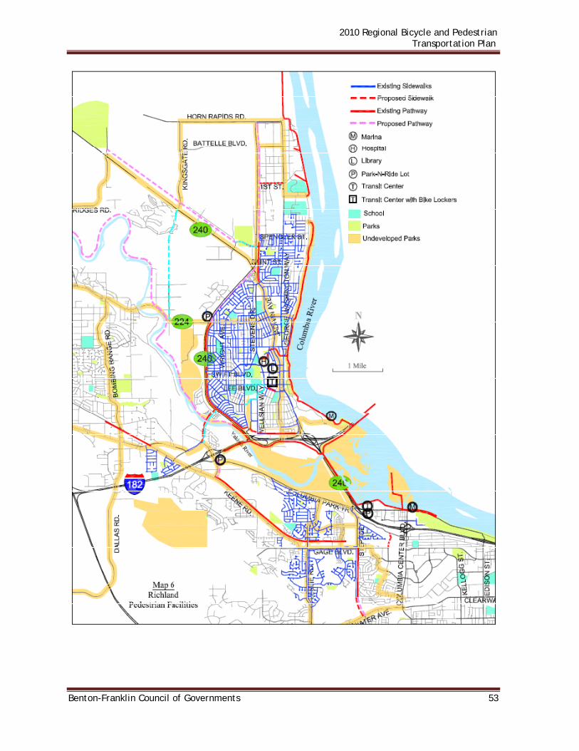
2010 Regional Bicycle and Pedestrian Transportation Plan
Benton-Franklin Council of Governments 53

2010 Regional Bicycle and Pedestrian Transportation Plan
54 Benton-Franklin Council of Governments
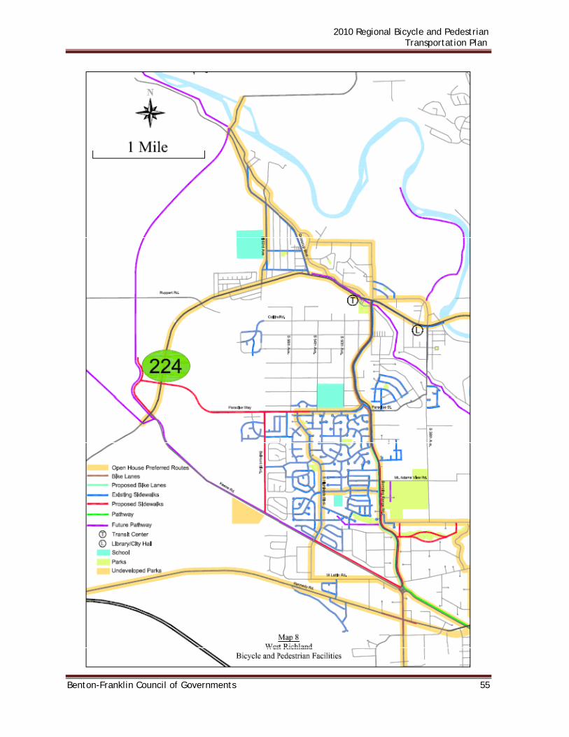
2010 Regional Bicycle and Pedestrian Transportation Plan
Benton-Franklin Council of Governments 55

2010 Regional Bicycle and Pedestrian Transportation Plan
56 Benton-Franklin Council of Governments
FRANKLIN COUNTY Franklin County is predominantly rural, consisting of irrigated and dry land farm and range lands. As with any rural county, bicycle and pedestrian travelers in these areas utilize the county road shoulders that in most places are narrow and function as part of the roadway lanes. Franklin County has no ordinance to regulate the use of bicycles. Franklin County utilizes a combination of local, state, and federal funds to finance transportation improvements. Numerous county road segments have been hard surfaced to “all weather” status to the benefit of motorized and non-motorized travel. Additional planned projects will all-weather surface and widen roads where needed to provide adequate shoulder width for non-motorized travel. Franklin County does not conduct bicycle safety programs. The program offered by the Pasco Police Department fulfills that need. The Comprehensive Plan specifies joint county/city standards for urban growth areas, including streets and sidewalks; promotes development of a bi-county (Franklin/Benton) bicycle trail system; and supports utilization of Columbia River dikes for recreation. Living areas should be located within proximity of transit, schools, shopping areas, parks, activity centers, and employment centers. County policy encourages efficient multi-modal and non-motorized transportation systems based on regional priorities and coordinated with county and city comprehensive plans. A non-motorized transportation objective is to meet the needs of bicyclists, pedestrians, and equestrians traveling on county roads and to encourage provision of non-motorized facilities, including sidewalks, where it is appropriate to provide safe and convenient access between properties and facilities. In Basin City, an unincorporated rural settlement located in the north central portion of the county, the county completed a project in 1999 on Bailie Boulevard that consisted of a sidewalk, and some walkway and warning lights between R 170 and the elementary school. In the past, students were using the roadway shoulders. The Columbia Plateau Trail, a relatively undeveloped 130 mile rail-trail connecting an area east of Pasco, near Ice Harbor Dam, to Fish Lake, a Spokane County Park near Cheney, is managed by the State Parks and Recreation Commission. The trail utilizes an abandoned Burlington Northern Railroad line and offers great opportunity for multi-use trail development. The trail will be crushed rock surfaced for use by pedestrians, equestrians, and mountain bicyclists. The property, through a master planning effort approved in June of 1998, is scheduled to be developed in phases. The original intent was to complete a portion in the north from Cheney to Amber Lake as well as the segment from Ice harbor Dam to Snake River Junction in the south. The north segment has been completed and provides 23 miles of trail from Cheney to Williams Lake Road. State Parks has also completed the southern segment, which has a length of 15 miles. With the completion of these segments, approximately 38 miles, roughly 30 percent of the overall trail has been developed.

2010 Regional Bicycle and Pedestrian Transportation Plan
Benton-Franklin Council of Governments 57
The missing link between Pasco and Ice Harbor Dam is still uncertain. While it was discussed during the master planning process, a solution was not identified. The park ownership extends from Ice Harbor Dam to a point about 0.5 miles east of Highway 12. From this location, it is a relatively short distance to Sacajawea State Park and a link to the Sacagawea Heritage Trail. Once completed, the Trail will include a link between Sacajawea State Park and the trail at Ice Harbor Dam, however, where that link will be has not been specified. Map 9 shows Franklin County bicycle and pedestrian facilities. CONNELL Pedestrian activity in Connell is centered in the downtown area and in nearby parks, the Community Center, and facilities such as the elementary, junior, and senior high schools. Continuous sidewalks and marked crosswalks are limited and usually in the downtown area. Part of the objectives of the city is to add more sidewalks as main roadways are reconstructed or resurfaced and provide incentives for pedestrians to walk to the park for concerts and other summer activities. For the most part, Connell’s street system is sufficiently wide to accommodate bicycles and motorized traffic, provided intermittent on-street parking does not create a hazard. There are currently no striped or signed bicycle lanes. The City’s bicycle ordinance restricts bicycles to daytime use on Columbia Avenue; however, bicycles may cross Columbia Avenue. Bicycles are not allowed on sidewalks. Map 10 depicts pedestrian/bicycle facilities in Connell. Most existing sidewalks are three to five feet wide, old, and in various conditions. Handicap ramps are non-existent except with newer, wider sidewalks along Columbia Avenue through the commercial area. Like other small cities, Connell must rely heavily upon state and federal funding sources to accomplish many transportation improvements. Its limited funds must be dedicated to maintenance and operations, with bicycle and pedestrian improvements often achieved in concert with a street project. For example, in 2002 and 2003, the city utilized a grant from the Transportation Improvement Board to finance improvements on Clark Street from North Columbia Avenue to Cemetery Road. Those improvements included a five-foot sidewalk on both sides, facilitating access to the schools. A goal in the transportation element is to develop, maintain and operate a balanced, safe and efficient multi-modal transportation system. A policy supports this goal to form local improvement districts (LIDs) to improve existing substandard streets, including provision of sidewalks and bicycle accommodations where appropriate. As an additional goal, the city recognizes bicycle and pedestrian movement as a basic means of circulation and assures adequate accommodation of bicycle, pedestrian and physically challenged persons needs in all transportation policies and facilities. Policies supporting the above goal include: provide a system of bicycle routes and pedestrian walkways that link neighborhoods and public facilities; take advantage of

2010 Regional Bicycle and Pedestrian Transportation Plan
58 Benton-Franklin Council of Governments
existing corridors for multiple use trails; require sidewalks on both sides of the street in public and private development within the urban area; require residential developments to provide bicycle friendly streets and sidewalks; develop and/or adopt design standards for bicycle and pedestrian facilities; require commercial centers be located and designed to facilitate access and circulation by alternative modes of transportation; maintain roads, sidewalks and pathways in a safe condition; promote bicycle safety programs; promote enforcement of bicycle traffic laws; identify and include appropriate pedestrian and bicycle elements in street improvement projects in the six-year TIP; include stand-alone pedestrian and bicycle projects in the TIP; and actively seek state and federal grants for non-motorized transportation projects. The plan also recommends development of a bike and walking path along Esquatzel Coulee. The City’s Parks and Recreation element contains a policy that would develop a system of trails and pathways that interconnect local and regional destinations.
Multiple unfunded planning projects in the current six-year Transportation Improvement Program (TIP) are proposed to include sidewalks. These include: Projects to construct curb, gutter, and sidewalks on East Birch Street and Hawthorn Street; New street construction to include sidewalks on extensions of South Sixth and Ford Streets; and street reconstruction projects to include sidewalk on West Adams Street and South Burke Avenue.
Also in the unfunded portion of the six year plan are stand-alone sidewalk projects on East Clark from Columbia Avenue to Ford Avenue, and Date Street from Columbia Avenue to City Park. As with other small cities, Connell relies upon state and federal funding sources to implement such projects.
In 2009, a new elementary school is being planned on West Clark Street which will centralize school facilities. This relocation will alter existing bike and pedestrian patterns which will be addressed in order to provide suitable accommodations.
Long-range planning also includes a new BNSF Railroad/Esquatzel Coulee overcrossing connecting north and south Sixth Avenue. Sidewalks and wide shoulders would facilitate student pedestrian/bicycle travel from south Connell to the schools on West Clark Street.
The TIP includes two unfunded pedestrian/bicycle paths, one on the old railroad right of way from Columbia Avenue to the SR 395 pathway near Ford Street; the other would extend the SR 395 pathway northerly from Clark Street to North Columbia Avenue (currently signed as Davis Way). KAHLOTUS
Pedestrian activity is centered in the downtown area, the nearby parks, and the school complex. Continuous sidewalks and marked crosswalks are limited and usually in the downtown area. An objective of the city is to add more sidewalks as main roadways are reconstructed or resurfaced and provide incentives for pedestrians to walk to the park for concerts and other summer activities. Current design standards require at least six-foot widths. Handicap ramps are non-existent.
For the most part, the existing street system is sufficiently wide to accommodate bicycles

2010 Regional Bicycle and Pedestrian Transportation Plan
Benton-Franklin Council of Governments 59
and motorized traffic, provided that parking does not create a hazard. Bicycle travel on the city’s streets is shared with automobiles. There are currently no striped or signed bicycle lanes. All major street improvement projects will also consider bicycle needs, whether or not bicycle lanes are to be provided. Kahlotus requires a light of sufficient power to be visible one hundred and fifty feet in the direction the bicycle or tricycle is heading on any public street.
Existing sidewalks are on the south side of Weston Street and a partial segment on the north side of Weston Street, both sides of Durrum and on the east side of Maryland adjacent to the park. Additional sidewalks are limited to short segments of Spokane Avenue, Weston Street, Cooper Avenue, Durrum Avenue, and Martin Street serving the school, the city hall, and the fire station. Most are three to five feet wide, old, and in various conditions. The City receives revenues for transportation projects from several funding sources, including: federal monies through competitive grants and direct allocation; state per capita revenues and competitive grants; and local improvement districts (LIDs) for specific approved transportation projects assessed to benefit properties. Like other small cities, Kahlotus must rely heavily upon state and federal funding sources to accomplish many transportation improvements. A recent example is sidewalk replacement project on Martin Street, which was completed with participation from the State Transportation Improvement Board. A goal in the transportation element is to develop, maintain and operate a balanced, safe and efficient multi-modal transportation system. A policy supports this goal to form local improvement districts (LIDs) to improve existing substandard streets, including provision of sidewalks and bicycle accommodations where appropriate. As an additional goal, the city recognizes bicycle and pedestrian movement as a basic means of circulation and assures adequate accommodation of bicycle, pedestrian and physically challenged person’s needs in all transportation policies and facilities. Policies supporting the above goal include: provide a system of bicycle routes and pedestrian walkways that link neighborhoods and public facilities; take advantage of existing corridors for multiple use trails; require sidewalks on both sides of the street in public and private development within the urban area; require residential development to provide bicycle friendly streets and sidewalks; develop and/or adopt design standards for bicycle and pedestrian facilities; require commercial centers be located and designed to facilitate access and circulation by alternative modes of transportation; maintain roads, sidewalks and pathways in a safe condition; promote bicycle safety programs; promote enforcement of bicycle traffic laws; identify and include appropriate pedestrian and bicycle elements in street improvement projects in the six-year TIP; include stand-alone pedestrian and bicycle projects in the TIP; and actively seek state and federal grants for non-motorized transportation projects. The City’s Parks and Recreation element contains a policy that would develop a system of trails and pathways that interconnect local and regional destinations.

2010 Regional Bicycle and Pedestrian Transportation Plan
60 Benton-Franklin Council of Governments
To facilitate school access, the city comprehensive plan recommends development of a multiple use trail along Courtwright Street from Durrum to Spokane Avenues then north along Spokane Avenue to Harris Street. The plan also recommends connecting to the Columbia Plateau Trail from the east side of Spokane Avenue between Weston and Washington Streets. Existing and proposed bicycle and pedestrian facilities for Kahlotus are shown on Map 11. MESA Pedestrian/bicycle activity is oriented toward the downtown area, the city park and the school. Lacking sufficient tax base, the city is challenged to maintain, let alone improve the street system. The majority of the street system must rely on local funding and, therefore, is in need of improvements. State and federal funds may be sought for those few streets being eligible. Mesa relies upon state funding for transportation improvements. For example, in 2000, Transportation Improvement Board (TIB) funds were used to widen Manton Way between May Avenue and Park Avenue and install a sidewalk on one side of the project. Additionally, a stand-alone pedestrian/bicycle pathway from the May Avenue/Short Street intersection southerly to Pepiot Road, also financed by TIB, has been completed. The City of Mesa relies upon state laws for regulation of bicycle operations. A goal in the transportation element is to develop, maintain and operate a balanced, safe and efficient multi-modal transportation system. A policy supports this goal to form local improvement districts (LIDs) to improve existing substandard streets, including provision of sidewalks and bicycle accommodations where appropriate. As a goal, the city recognizes bicycle and pedestrian movement as a basic means of circulation and assures adequate accommodation of bicycle, pedestrian and physically challenged person’s needs in all transportation policies and facilities. Policies supporting the above goal include: provide a system of bicycle routes and pedestrian walkways that link neighborhoods and public facilities; take advantage of existing corridors for multiple use trails; require sidewalks on both sides of the street in public and private development within the urban area; require residential development to provide bicycle friendly streets and sidewalks; develop and/or adopt design standards for bicycle and pedestrian facilities; require commercial centers be located and designed to facilitate access and circulation by alternative modes of transportation; maintain roads, sidewalks and pathways in a safe condition; promote bicycle safety programs; promote enforcement of bicycle traffic laws; identify and include appropriate pedestrian and bicycle elements in street improvement projects in the six-year TIP; include stand-alone pedestrian and bicycle projects in the TIP; and actively seek state and federal grants for non-motorized transportation projects.

2010 Regional Bicycle and Pedestrian Transportation Plan
Benton-Franklin Council of Governments 61
The City’s Parks and Recreation element contains a policy that would develop a system of trails and pathways that interconnect local and regional destinations. Mesa pedestrian facilities are shown on Map 12. PASCO East-west routes in Pasco are limited because of disruptions caused by north-south highways or rail lines. Generally, the residential street system, if it has sidewalks and paved streets, is adequate for pedestrian and bicycle transportation. The city core, defined by SR 395 to the west and the railroad to the east, has a substantial network of sidewalks. Few streets are without sidewalks on one or both sides. East Pasco (railroad track easterly) has sidewalks on 80 percent of all residential streets. The westerly fringe of the city, and the urban growth area have minimal sidewalks. Recently implemented developments north of I-182 have included sidewalks in the infrastructure. Overall 60-plus percent of all commercial and residential streets in Pasco have sidewalks. At the present time there are no signed or designated bike routes to guide unfamiliar cyclists around the “bikes prohibited” segment of SR 395 from Court Street in Pasco to the SR 240 interchange in Kennewick. The transportation element of Pasco’s comprehensive plan states as a goal continuing to provide and maintain an effective and convenient street system. Policies supporting this goal include development of an interconnected network of street, trails and other public ways while preserving neighborhood identity; and build streets and sidewalks without interrupted or patchwork rights-of-way or construction. A second goal is to encourage efficient, alternate and multi-modal transportation systems. Policies supporting this goal include encouraging greater use of bicycles and walking by providing safe and purposeful bicycle and pedestrian routes; and encouraging park-and-ride lots for bicycles and automobiles. The plan also has a goal to provide pedestrian and vehicular communications through neighborhoods to help foster a sense of community. A policy supporting this goal is to direct land developments to incorporate frequent networks for motor vehicle ways and pedestrian/bicycle greenways connecting to abutting developments, schools, parks, and employment centers. The city’s 2005 Park and Recreation Plan indicates trail corridors should be developed to include trees, landscaped areas, open lawn areas, seating areas, and some picnic facilities. The plan proposes ten future parks and improvements or expansions at many existing parks. Pasco utilizes a combination of local, state, and federal funds to finance transportation improvement projects. Since 1997 the Pasco Police Department has conducted annual bicycle rodeos to teach bicycle safety. Entrants learn helmet safety, riding skills, register their bicycles, and have their bikes inspected. The Sacagawea Heritage Trail Project includes construction of a bicycle and pedestrian

2010 Regional Bicycle and Pedestrian Transportation Plan
62 Benton-Franklin Council of Governments
pathway on both sides of the Columbia River. As part of the project, the Port of Pasco recently constructed a trail segment from Grey Avenue to Sacagawea Park Road; and Pasco has completed two Trail segments in conjunction with lowering the levee adjacent to the River: Phase I is from 28th Avenue just east of the Blue Bridge (SR 395) to 13th Avenue; Phase II constructs the trail from 13th Avenue to Grey Avenue. The Port of Pasco project and Phase I for the City of Pasco were completed in 2005. Pasco’s Phase II project was completed in 2008. Ben Franklin Transit buses serve Pasco via the 22nd Avenue Transit Center with connections to Kennewick, Richland, West Richland, Benton City, Prosser and the unincorporated area of Finley. Bike racks on the buses facilitate intermodal trips. The Pasco Intermodal Depot, completed in 1998, is served by Amtrak, Greyhound, Ben Franklin Transit and local taxi service. The facility is accessible to pedestrians and bicyclists. The Tri-Cities Airport, also in Pasco, is accessible to pedestrian and bicycle travel. Map 13 depicts pedestrian facilities in Pasco/Riverview area. Map 14 shows bike routes and paths in the Pasco/Riverview area.

2010 Regional Bicycle and Pedestrian Transportation Plan
Benton-Franklin Council of Governments 63

2010 Regional Bicycle and Pedestrian Transportation Plan
64 Benton-Franklin Council of Governments

2010 Regional Bicycle and Pedestrian Transportation Plan
Benton-Franklin Council of Governments 65

2010 Regional Bicycle and Pedestrian Transportation Plan
66 Benton-Franklin Council of Governments

2010 Regional Bicycle and Pedestrian Transportation Plan
Benton-Franklin Council of Governments 67

2010 Regional Bicycle and Pedestrian Transportation Plan
68 Benton-Franklin Council of Governments

2010 Regional Bicycle and Pedestrian Transportation Plan
Benton-Franklin Council of Governments 69
WALLA WALLA COUNTY Transportation funding can be categorized into two types, the first being local and the second, state and federal. The only current local transportation revenue source that provides money for Walla Walla County is the county road levy. Funds may also be available through state and federal grants. Federal grant funds are administered by the Benton-Franklin-Walla Walla Regional Transportation Planning Organization (RTPO). State grants may be available from several programs, but most are funded through a common source, the state gas tax. Walla Walla County also receives allocations of the state gas tax revenues, but must rely on the legislature to authorize additional allocations. The following are the goals and policies regarding non-motorized transportation as they appear in the Comprehensive Plan of 2007. Goal TR 4: To promote pedestrian and bicycle travel by providing convenient, accessible, safe and attractive facilities where feasible. Policy TR-23: Encourage non-motorized forms of transportation to reduce air pollution, noise, fuel consumption, and congestion. Policy TR-24: Coordinate with adjoining jurisdictions regarding the continuity of the non-motorized transportation system in UGAs including safe walking routes to schools and other public facilities. Policy TR-25: Identify and designate planned improvements for pedestrian and bicycle facilities in UGAs. Policy TR-26: Apply WSDOT/AASHTO design standards for bike paths, sidewalks, and paths in new developments where feasible. Policy TR-27: Encourage non-motorized forms of transportation to encourage enhanced community access and promote healthy lifestyles. Policy TR-28: Provide for regular maintenance of non-motorized transportation facilities. Policy TR-29: Require new developments to provide internal non-motorized circulation systems as well as links to existing or planned external systems where feasible. Map 15 shows bike routes currently being utilized in Walla Walla County. COLLEGE PLACE The size and scale of the City of College Place make it an enjoyable place to bike and walk. Sidewalks are an obvious way to maintain and enhance the 'walkability' of a community. College Avenue, SE 12th St. and Larch Avenue are the main areas of the City with continuous sidewalks. Development in the City that occurred before 1980 did not require sidewalks to be installed. Consequently, the majority of the established

2010 Regional Bicycle and Pedestrian Transportation Plan
70 Benton-Franklin Council of Governments
neighborhoods in College Place do not have sidewalks.
Bicycles are another important mode of transportation in College Place. The Walla Walla Regional Bicycle-Pedestrian Advisory Committee was established by the cities of College Place and Walla Walla and by Walla Walla County. Its purpose was to develop and implement the "Walla Walla Regional Bicycle and Pedestrian Plan". The plan sets forth a 20 year comprehensive bicycling and pedestrian system for the Walla Walla region and lists an inventory of the City of College Place's existing bicycle routes, including the following:
College Avenue between SE 12th and NE 'C' Street NE 'C' Street between College Avenue and Myra Road Myra Road between 'C' Street and the Dalles-Military Road SE 12th Street between Myra Road and College Avenue
Currently, none of these streets are signed as bicycle routes and bicycles share the City's streets with the much more dominant auto and truck traffic. While exact bike and trail routes through the cities of College Place and Walla Walla have not yet been determined, there has been an on-going program to develop a bike path system linking Rooks Park east of Walla Walla and Whitman mission west of College Place. At this time, as segments of the Rooks Park/Whitman Mission path, there exists a bike path just north of Walla Walla along Mill Creek from Rooks Park to Eastgate Lions Park in Walla Walla and from Plaza Way and SR-125, past Fort Walla Walla Park, to Larch Street in College Place. There is also a path from Walla Walla Community College along Isaacs Avenue to its intersection with Mill Creek Road and a path from the Veteran’s Complex along SR-125 to Adair Vista Park in Walla Walla. The County has dedicated the vacated roadway into Whitman Mission from Last Chance Road as a bike path. College Place has completed bike and pedestrian facilities along the new Whitman Extension connecting Myra Road and SE Larch Street. To the west, College Place has also completed bike and pedestrian facilities along Whitman Drive between Academy Way and the city limits. The City’s Whitman Central Corridor project, to be constructed in 2011, will provide a nearly continuous multi-use path through the center of the city along Whitman Drive. The Comprehensive Plan contains several goals relevant to bicycle and pedestrian travel. Land use goals listed include: safe pedestrian travel in residential areas; increased pedestrian activity and accessibility along College Avenue; and improvement of sidewalks through widening and elimination of obstacles. A transportation goal is to establish a system of bicycle and pedestrian trails and routes that link neighborhoods and public facilities and that enhance the walking and bicycling experience. Policies supporting that goal include: determine where bicycle and pedestrian routes should be designated and encourage their construction and use; require sidewalks in all new and existing residential subdivisions, commercial and other areas; eventual provision of sidewalks along existing roadways where they do not now exist; priority given to those

2010 Regional Bicycle and Pedestrian Transportation Plan
Benton-Franklin Council of Governments 71
streets that provide school access, and those that are now, or where there is concern for pedestrian safety; and signing of designated bicycle routes through the City. In the goals and policy section, the Comprehensive Plan lists development of a pedestrian/bicycle trail along Stone Creek between Larch Avenue and Myra Road as a priority. It also lists development of a pedestrian/bicycle trail connecting from Larch Avenue southwest to Ell's 40 in cooperation with the County and Washington State Department of Transportation as a priority. This trail has been completed from Ell’s 40 to South College Avenue. Valley Transit buses serve College Place and Walla Walla. Bike racks on the buses facilitate intermodal trips. Map 16 shows bicycle facilities in College Place. Prescott The basic street pattern in Prescott is a classic grid that provides access throughout the community. In 1998 and 1999 Prescott spent $37,000 per year for the repair of city streets in an effort to follow its six-year TIP. However, the city has been unable to provide the funding needed for transportation improvements. Prescott, simply and plainly, does not receive sufficient revenue to cover basic governmental services, transportation operating costs and street improvements as well Transportation improvements will need to be financed from outside sources for the future. If funding from outside sources is not available, the City Council will prioritize projects, first emphasizing maintenance of existing facilities and safety issues. Considering the adopted Level of Service (C) and the projected growth rate, it is highly unlikely that any improvements would be required to maintain the adopted LOS. Needed improvements to Prescott’s transportation system are most likely limited to long-term maintenance, installation of curbs, gutters and sidewalks. A goal of the Comprehensive Plan is to support efforts to obtain grant funding for transportation amenities such as sidewalks. In 2000, Prescott received a grant from the Transportation Improvement Board to remove and replace existing sidewalks along SR 124 from B Street to G Street. Prescott’s last TIP listed an unfunded project to widen First Street from A Street to E Street which included sidewalks.

2010 Regional Bicycle and Pedestrian Transportation Plan
72 Benton-Franklin Council of Governments
Waitsburg The City is currently pedestrian-and bicycle-friendly due to the low traffic volumes which make the City streets relatively safe for walking and biking. The size and scale of the City make these modes of transportation both practical and pleasant. As development increases, traffic will also increase, which may create more of a conflict between automobile traffic and pedestrian and bicycle traffic. As such, the City should continue to improve bicycle and pedestrian amenities.
Sidewalks are an obvious way to maintain and enhance the 'walkability' of a community. As new development occurs, sidewalks should be provided as a normal part of the permit requirements, regardless of whether there are sidewalks adjacent to the site of the proposed development. The long term goal is to complete a citywide sidewalk network in conjunction with street improvements.
Continuing the basic street grid in new developments is important in maintaining the connectedness of the pedestrian walkways. Isolated cul-de-sacs and single-access subdivisions increase walking distances and create barriers to other portions of town. Where such a configuration is appropriate due to natural features or existing development, then pedestrian and/or bicycle connections should be made to adjacent blocks. The Waitsburg comprehensive plan cites a goal of establishing a system of bicycle and pedestrian paths that link neighborhoods and public facilities and that enhance the walking and biking experience. Several policies are supportive of the goal. These include encouraging the use of fuel-efficient modes of transportation; striving to provide alternative transportation systems, both vehicular and non-vehicular, including but not limited to mass transit, bicycle routes and pedestrian walkways; and requiring off-street parking to integrate with, or at least not interfere with, pedestrian amenities, access to future transit facilities and access by bicycles. Additional policies include studying alternative routes, especially between schools and residential areas, to determine where pedestrian and bicycle routes should be designated and encourage their construction and use; requiring installation of sidewalks as part of every subdivision and most short plats; eventual provision of sidewalks along existing roadways where they do not exist, with priority given to those roads that now or will in the future carry higher volumes of traffic; development of a multiple use trail along the Touchet River; and purchase and installation of bicycle racks at the park and on Main Street. The policy on bicycle racks has been implemented and racks are now available in Preston Park and through the downtown. Since Preston Park has been expanded, a multi-use path along the park is included in the expansion to provide safe access throughout the downtown area to and from the park. The City is actively pursuing funding for the multi-use path. The City should consider striping City streets for a bicycle lane, particularly near schools. Many residential areas are not connected by a walkway to recreational areas, schools, and shopping areas. In the near term, one major project has been identified:

2010 Regional Bicycle and Pedestrian Transportation Plan
Benton-Franklin Council of Governments 73
School Walking Routes: The school's facilities are separated by several blocks. During much of the year, students must walk between facilities. This occurs several times a day, each day, and the students range in age from third grade through high school. Currently the walking paths between school facilities are not furnished with sidewalks for the entire route, and in places where sidewalks do exist; they are inadequate in some cases. This situation creates safety hazards. The school district and the city recognize this as a concern and both agree that improvements to existing sidewalks and construction of new sidewalks where none now exist are important. To that end, the city has projected an expenditure of $275,000 for school sidewalks.
The City has identified several transportation projects that will need to be addressed in the future. All of these will require at least some financing from sources outside the City. Primarily for that reason, these projects are not currently scheduled. It is anticipated that these projects will be undertaken, as financing opportunities become available, sometime in the years 2009 - 2023.
West Seventh Street: Main Street to West City Limits - This is a heavily traveled City street. It will require a new road bed, repaving, and installation of curbs, storm sewer, and sidewalks.
Public School Sidewalk Reconstruction: Weller Street to East 8th Street – Reconstruct/Install five-foot sidewalk.
City-Wide Sidewalks: Many streets in the City do not have sidewalks. Some of the existing sidewalks are in need of repair or reconstruction. The City has established a goal to eventually install good, serviceable sidewalks on all of the principal Streets. Map 17 shows existing sidewalks in Waitsburg. Walla Walla Sidewalks are the primary pedestrian facility and are found throughout the City. There are many gaps in the sidewalk system where new sidewalks are needed. Currently, about 70 percent of the City’s primary streets have sidewalks. Also, many areas do no have sufficient wheelchair ramps. New subdivision developments are required by ordinance to install sidewalks with wheel chair ramps.
The City provides both on-street and off-street bicycle facilities. On-street facilities primarily consist of striped bicycle lanes between the travel lane and the parking lane and widened shared-use lanes. Off-street facilities consist primarily of asphalt pathways. The City of Walla Walla has procured multiple bike racks as well. The Walla Walla Zoning Code has no requirements to meet bicycle or pedestrian needs. Off-street parking requires a buffer or barrier between the parking and right-of-way, but has no requirement for pedestrian access from the street to the building. The Walla Walla Subdivision Code, Section 19.32.020, Street Improvements, requires sidewalks on both sides of the street in new developments, and it requires street lighting and trees in specified situations. The Subdivision Code refers to the Municipal Code for

2010 Regional Bicycle and Pedestrian Transportation Plan
74 Benton-Franklin Council of Governments
street and sidewalk standards. Connectivity of bikeways and walkways is not addressed. The Walla Walla Municipal Code Section 12.04.015, Sidewalks, refers to state guidelines for construction standards. In addition, wheelchair ramp construction is to conform to state standards. The Walla Walla Urban Area Comprehensive Plan 2007 Review and Update contains multiple specific and general references to nonmotorized transportation. A goal of the Plan is to seek unity through strong linkages between the City and County, Region and beyond, while an objective is to collaborate regionally on transportation and communications including the expansion of destinations, connections and modes. Specific policies state that: The region’s communities should seek to identify ways to link their roads, trails,
parks, and open spaces together; Accessibility by pedestrians, cyclists and automobiles should be considered in each
commercial center; Walla Walla’s circulation system should reflect the mobility needs of all segments of
the population A comprehensive trail system should be created to serve the community’s needs for
a safe, healthy and convenient recreation outlet and to provide an alternative to car travel;
Streets should incorporate facilities for non-motorized transportation; and Owners of railway rights of way should work with stakeholders to explore potential
conversion of their abandoned rail corridors to trails for public access.
The Parks and Recreation Department maintains several bicycle and pedestrian trails in the community. These include the Mill Creek trail from Eastgate Lions Park to the Community College, the Highway 12 trail from Wellington Avenue to 8th Avenue, and the Fort Walla Walla Park trail from the amphitheater to the Veterans Administration Medical Center entrance on Chestnut Street. In 2005, the City adopted The Walla Walla Regional Bicycle and Pedestrian Plan. The Plan states the goal of the City of Walla Walla is to develop a walkable, pedestrian friendly, American Disabilities Act (ADA) accessible and bike friendly community. Multiple action statements describe how that goal will be achieved, including: Target bicycle and pedestrian funding to priorities that improve mobility and safety, especially for youths and seniors; Work with multiple partners to expand bike and pedestrian facilities; Work to ensure that walking and cycling for transportation are a vital – real option as part of our transportation system and are incorporated as an integral part of all other transportation systems at the City and County level; Work to improve universal access including Americans with Disabilities Act compliance on projects; and Work with United Blind of Walla Walla in installing accessible pedestrian signals. The Plan also establishes, by ordinance, a “Bicycle Road Fund” which formalizes the application of bicycle license fees toward the construction and maintenance of bicycle paths.

2010 Regional Bicycle and Pedestrian Transportation Plan
Benton-Franklin Council of Governments 75
The City supports the City Bicycle and Pedestrian Advisory Committee. The Committee helped to develop the 2005 Bicycle and Pedestrian Element. The City’s projected needs are identified in a project list contained in the Bicycle and Pedestrian Element. Walla Walla has four tour organized walks through their historic districts: The Downtown Walk highlights the history, restoration and renovation of Downtown Walla Walla. The renovation of downtown Walla Walla has received multiple national revitalization awards. The Historic Homes Walk, Up Boyer and Pioneer Park Walk, and the Fort Walla Walla Walk all take you past many historic buildings and sites including vintage homes, spanning several architectural periods. More information on the walks, including maps, may be found at www.wallawalla.org. Valley Transit buses serve College Place and Walla Walla. Bike racks on the buses facilitate intermodal trips. Map 18 shows existing and proposed bike routes in Walla Walla.

2010 Regional Bicycle and Pedestrian Transportation Plan
76 Benton-Franklin Council of Governments

2010 Regional Bicycle and Pedestrian Transportation Plan
Benton-Franklin Council of Governments 77

2010 Regional Bicycle and Pedestrian Transportation Plan
78 Benton-Franklin Council of Governments

2010 Regional Bicycle and Pedestrian Transportation Plan
Benton-Franklin Council of Governments 79

2010 Regional Bicycle and Pedestrian Transportation Plan
80 Benton-Franklin Council of Governments
STATE LAWS AND POLICIES
STATE LAWS REGARDING BICYCLES The sections herein are the “rules of the road” chapters outlining the bicyclist’s rights and responsibilities as defined in the Revised Code of Washington. Laws referring to various bicycle safety and education programs are not included. 46.04.071 Bicycle.
“Bicycle” means every device propelled solely by human power upon which a person or persons may ride, having two tandem wheels either of which is sixteen or more inches in diameter, or three wheels, any one of which is more than twenty inches in diameter.
46.61.150 Obedience to and required traffic control devices.
1) The driver of any vehicle, every bicyclist, and every pedestrian shall obey the instructions of any official traffic control device applicable thereto placed in accordance with the provisions of this chapter, unless otherwise directed by a traffic or police officer, subject to the exception granted the driver of an authorized emergency vehicle in this chapter. 2) No provision of this chapter for which official traffic control devices are required shall be enforced against an alleged violator if at the time and place of the alleged violation an official device is not in proper position and sufficiently legible or visible to be seen by an ordinarily observant person. Whenever a particular section does not state that official traffic control devices are required, such section shall be effective even though no devices are erected or in place. 3) Whenever official traffic control devices are placed in position approximately conforming to the requirements of this chapter, such devices shall be presumed to have been so placed by the official act or direction of lawful authority, unless the contrary shall be established by competent evidence. 4) Any official traffic control device placed pursuant to the provisions of this chapter and purporting to conform to the lawful requirements pertaining to such devices shall be presumed to comply with the requirements of this chapter, unless the contrary shall be established by competent evidence.
46.61.110 Overtaking on the Left
The following rules shall govern the overtaking and passing of vehicles proceeding in the same direction, subject to those limitations, exceptions and special rules hereinafter stated: 1) The driver of a vehicle overtaking other traffic proceeding in the same direction shall pass to the left thereof at a safe distance and shall not again drive to the right side of the roadway until safely clear of the overtaken traffic. 2) The driver of a vehicle approaching a pedestrian or bicycle that is on the roadway or on the right-hand shoulder or bicycle lane of the roadway shall pass to the left at a safe distance to clearly avoid coming into contact with the pedestrian

2010 Regional Bicycle and Pedestrian Transportation Plan
Benton-Franklin Council of Governments 81
or bicyclist, and shall not again drive to the right side of the roadway until safely clear of the overtaken pedestrian or bicyclist. 3) Except when overtaking and passing on the right is permitted, overtaken traffic shall give way to the right in favor of an overtaking vehicle on audible signal and shall not increase speed until completely passed by the overtaking vehicle.
46.61.125 Further Limitations on Overtaking on the Left
1) No vehicle shall be driven on the left side of the roadway under the following conditions: (a) When approaching or upon the crest of a grade or a curve in the highway where the driver's view is obstructed within such distance as to create a hazard in the event other traffic might approach from the opposite direction; (b) When approaching within one hundred feet of or traversing any intersection or railroad grade crossing; (c) When the view is obstructed upon approaching within one hundred feet of any bridge, viaduct or tunnel; (d) When a bicycle or pedestrian is within view of the driver and is approaching from the opposite direction, or is present, in the roadway, shoulder, or bicycle lane within a distance unsafe to the bicyclist or pedestrian due to the width or condition of the roadway, shoulder, or bicycle lane. 2) The foregoing limitations shall not apply upon a one-way roadway, nor under the conditions described in RCW 46.61.100(1)(b), nor to the driver of a vehicle turning left into or from an alley, private road or driveway.
46.61.126 Legal Duties of Bicyclists and Pedestrians
Nothing in RCW 46.61.110, 46.61.120, or 46.61.125 relieves pedestrians and bicyclists of their legal duties while traveling on public highways.
46.61.160 Restrictions on use of limited-access highway – Use by bicyclists.
The department of transportation may by order, and local authorities may by ordinance or resolution, with respect to any limited access highway under their respective jurisdictions prohibit the use of any such highway by funeral processions, or by parades, pedestrians, bicycles or other nonmotorized traffic, or by any person operating a motor-driven cycle. Bicyclists may use the right shoulder of limited access highways except where prohibited. The department of transportation may by order, and local authorities may by ordinance or resolution, with respect to any limited-access highway under their respective jurisdictions, prohibit the use of the shoulders of any such highway by bicycles within urban areas or upon other sections of the highway where such use is deemed to be unsafe.
The department of transportation or the local authority adopting any such prohibitory regulation shall erect and maintain official traffic control devices on the limited access roadway on which such regulations are applicable, and when so erected no person may disobey the restrictions stated on such devices.

2010 Regional Bicycle and Pedestrian Transportation Plan
82 Benton-Franklin Council of Governments
46.61.161 Bicycles must Yield to Pedestrians on Sidewalks and Crosswalks
The driver of a vehicle shall yield the right-of-way to any pedestrian or bicycle on a sidewalk. The rider of a bicycle shall yield the right-of-way to a pedestrian on a sidewalk or crosswalk.
46.61.700 Parent or guardian shall not authorize or permit violation by a child or ward. No parent of any child and the guardian of any ward shall not authorize or knowingly permit any such child or ward to violate any of the provisions of this chapter. 46.61.710 Partial and Full Powered Mopeds on Bicycle Paths, Lanes and Sidewalks
1) No person shall operate a moped upon the highways of this state unless the moped has been assigned a moped registration number and displays a moped permit in accordance with the provisions of RCW 46.16.630. 2) Notwithstanding any other provision of law, a moped may not be operated on a bicycle path or trail, bikeway, equestrian trail, or hiking or recreational trail. 3) Operation of a moped, electric personal assistive mobility device, motorized foot scooter, or an electric-assisted bicycle on a fully controlled limited access highway is unlawful. Operation of a moped, motorized foot scooter, or an electric-assisted bicycle on a sidewalk is unlawful. 4) Removal of any muffling device or pollution control device from a moped is unlawful. 5) Subsections (1), (2), and (4) of this section do not apply to electric-assisted bicycles. Electric-assisted bicycles and motorized foot scooters may have access to highways, other than limited access highways, of the state to the same extent as bicycles. Subject to subsection (6) of this section, electric-assisted bicycles and motorized foot scooters may be operated on a multipurpose trail or bicycle lane, but local jurisdictions may restrict or otherwise limit the access of electric-assisted bicycles and motorized foot scooters, and state agencies may regulate the use of motorized foot scooters on facilities and properties under their jurisdiction and control. 6) Subsections (1) and (4) of this section do not apply to motorized foot scooters. Subsection (2) of this section applies to motorized foot scooters when the bicycle path, trail, bikeway, equestrian trail, or hiking or recreational trail was built or is maintained with federal highway transportation funds. Additionally, any new trail or bicycle path or readily identifiable existing trail or bicycle path not built or maintained with federal highway transportation funds may be used by persons operating motorized foot scooters only when appropriately signed. 7) A person operating an electric personal assistive mobility device (EPAMD) shall obey all speed limits and shall yield the right-of-way to pedestrians and human-powered devices at all times. An operator must also give an audible signal before overtaking and passing a pedestrian. Except for the limitations of this subsection, persons operating an EPAMD have all the rights and duties of a pedestrian.

2010 Regional Bicycle and Pedestrian Transportation Plan
Benton-Franklin Council of Governments 83
8) The use of an EPAMD may be regulated in the following circumstances: (a) A municipality and the department of transportation may prohibit the operation of an EPAMD on public highways within their respective jurisdictions where the speed limit is greater than twenty-five miles per hour; (b) A municipality may restrict the speed of an EPAMD in locations with congested pedestrian or nonmotorized traffic and where there is significant speed differential between pedestrians or nonmotorized traffic and EPAMD operators. The areas in this subsection must be designated by the city engineer or designee of the municipality. Municipalities shall not restrict the speed of an EPAMD in the entire community or in areas in which there is infrequent pedestrian traffic; (c) A state agency or local government may regulate the operation of an EPAMD within the boundaries of any area used for recreation, open space, habitat, trails, or conservation purposes.
46.61.750 Effect of regulations – Penalty.
1) It is a traffic infraction for any person to do any act forbidden or fail to perform any act required in RCW 46.61.750 through 46.61.780. 2) These regulations applicable to bicycles apply whenever a bicycle is operated upon any highway or upon any bicycle path, subject to those exceptions stated herein.
46.61.755 Traffic laws apply to persons riding bicycles.
Every person riding a bicycle upon a roadway shall be granted all the rights and shall be subject to all of the duties applicable to the driver of a vehicle by this chapter, except as to special regulations in RCW 46.61.750 through 46.61.780 and except as to those provisions of this chapter which by their nature have no application.
46.61.758 Hand signals.
All hand signals required of persons operating bicycles shall be given in the following manner: (1) Left turn. Left hand and arm extended horizontally beyond the side of the bicycle; (2) Right turn. Left hand and arm extended upward beyond the side of the bicycle, or right hand and arm extended horizontally to the right side of the bicycle; (3) Stop or decrease speed. Left hand and arm extended downward beyond the side of the bicycle. The hand signals required by this section shall be given before initiation of a turn.
46.61.760 Riding on bicycles.
1) A person propelling a bicycle shall not ride other than upon or astride a permanent and regular seat attached thereto. 2) No bicycle shall be used to carry more persons at one time than the number for which it is designed and equipped.
46.61.765 Clinging to vehicles.

2010 Regional Bicycle and Pedestrian Transportation Plan
84 Benton-Franklin Council of Governments
No person riding upon any bicycle, coaster, roller skates, sled, or toy vehicle shall attach the same or himself to any vehicle upon a roadway.
46.61.770 Riding upon roadways and bicycle paths. 1) Every person operating a bicycle upon a roadway at a rate of speed less than the normal flow of traffic at the particular time and place shall ride as near to the right side of the right through lane as is safe except as may be appropriate while preparing to make or while making turning movements, or while overtaking and passing another bicycle or vehicle proceeding in the same direction. A person operating a bicycle upon a roadway or highway other than a limited-access highway, which roadway or highway carries traffic in one direction only and has two or more marked traffic lanes, may ride as near to the left side of the left through lane as is safe. A person operating a bicycle upon a roadway may use the shoulder of the roadway or any specially designated bicycle lane if such exists. 2) Persons riding bicycles upon a roadway shall not ride more than two abreast except on paths or parts of roadways set aside for the exclusive use of bicycles.
46.61.775 Carrying articles.
No person operating a bicycle shall carry any package, bundle, or article which prevents the driver from keeping at least one hand upon the handlebars.
46.61.780 Lamps and other equipment on bicycles.
1) Every bicycle, when in use during the hours of darkness as defined in RCW 46.37.020, shall be equipped with a lamp on the front which shall emit a white light visible from a distance of at least five hundred feet to the front and with a red reflector on the rear of a type approved by the state patrol which shall be visible from all distances up to six hundred feet to the rear when directly in front of lawful lower beans of head lamps on a motor vehicle. A lamp emitting a red light visible from a distance of five hundred feet to the rear may be used in addition to the red reflector. 2) Every bicycle shall be equipped with a brake that will enable the operator to make the braked wheels skid on dry, level, clean pavement.
46.61.790 Intoxicated Cyclists 1) A law enforcement officer may offer to transport a bicycle rider who appears to be under the influence of alcohol or any drug and who is walking or moving along or within the right-of-way of a public roadway, unless the bicycle rider is to be taken into protective custody under RCW 70.96A.120. The law enforcement officer offering to transport an intoxicated bicycle rider under this section shall: (a) Transport the intoxicated bicycle rider to a safe place; or (b) Release the intoxicated bicycle rider to a competent person. 2) The law enforcement officer shall not provide the assistance offered if the bicycle rider refuses to accept it. No suit or action may be commenced or prosecuted against the law enforcement officer, law enforcement agency, the state of Washington, or any political subdivision of the state for any act resulting from

2010 Regional Bicycle and Pedestrian Transportation Plan
Benton-Franklin Council of Governments 85
the refusal of the bicycle rider to accept this assistance. 3) The law enforcement officer may impound the bicycle operated by an intoxicated bicycle rider if the officer determines that impoundment is necessary to reduce a threat to public safety, and there are no reasonable alternatives to impoundment. The bicyclist will be given a written notice of when and where the impounded bicycle may be reclaimed. The bicycle may be reclaimed by the bicycle rider when the bicycle rider no longer appears to be intoxicated, or by an individual who can establish ownership of the bicycle. The bicycle must be returned without payment of a fee. If the bicycle is not reclaimed within thirty days, it will be subject to sale or disposal consistent with agency procedures.
STATE LAWS REGARDING PEDESTRIANS
The sections herein are the “rules of the road” chapters outlining the pedestrian’s rights and duties as defined in the Revised Code of Washington. 46.04.160 Crosswalk
"Crosswalk" means the portion of the roadway between the intersection area and a prolongation or connection of the farthest sidewalk line or in the event there are no sidewalks then between the intersection area and a line ten feet therefrom, except as modified by a marked crosswalk.
46.04.400 Pedestrian. "Pedestrian" means any person who is afoot or who is using a wheelchair, a power wheelchair, or a means of conveyance propelled by human power other than a bicycle.
46.61.050 Obedience to and required traffic control devices.
1) The driver of any vehicle, every bicyclist, and every pedestrian shall obey the instructions of any official traffic control device applicable thereto placed in accordance with the provisions of this chapter, unless otherwise directed by a traffic or police officer, subject to the exception granted the driver of an authorized emergency vehicle in this chapter. 2) No provision of this chapter for which official traffic control devices are required shall be enforced against an alleged violator if at the time and place of the alleged violation an official device is not in proper position and sufficiently legible or visible to be seen by an ordinarily observant person. Whenever a particular section does not state that official traffic control devices are required, such section shall be effective even though no devices are erected or in place. 3) Whenever official traffic control devices are placed in position approximately conforming to the requirements of this chapter, such devices shall be presumed to have been so placed by the official act or direction of lawful authority, unless the contrary shall be established by competent evidence. 4) Any official traffic control device placed pursuant to the provisions of this chapter and purporting to conform to the lawful requirements pertaining to such devices shall be presumed to comply with the requirements of this chapter, unless

2010 Regional Bicycle and Pedestrian Transportation Plan
86 Benton-Franklin Council of Governments
the contrary shall be established by competent evidence. 46.61.060 Pedestrian Control Signals
Whenever pedestrian control signals exhibiting the words "Walk" or the walking person symbol or "Don't Walk" or the hand symbol are operating, the signals shall indicate as follows: 1) WALK or walking person symbol—Pedestrians facing such signal may cross the roadway in the direction of the signal. Vehicle operators shall stop for pedestrians who are lawfully moving within the intersection control area on such signal as required by RCW 46.61.235(1). 2) Steady or flashing DON'T WALK or hand symbol—Pedestrians facing such signal shall not enter the roadway. Vehicle operators shall stop for pedestrians who have begun to cross the roadway before the display of either signal as required by RCW 46.61.235(1). 3) Pedestrian control signals having the "Wait" legend in use on August 6, 1965, shall be deemed authorized signals and shall indicate the same as the "Don't Walk" legend. Whenever such pedestrian control signals are replaced the legend "Wait" shall be replaced by the legend "Don't Walk" or the hand symbol.
46.61.126 Pedestrians must follow traffic laws.
Nothing in RCW 46.61.110, 46.61.120, or 46.61.125 relieves pedestrians and bicyclists of their legal duties while traveling on public highways.
46.61.230 Pedestrians subject to traffic regulations. Pedestrians shall be subject to traffic-control signals at intersections as provided in RCW 46.61.060, and at all other places pedestrians shall be accorded the privileges and shall be subject to the restrictions stated in this chapter.
46.61.235 Stopping for pedestrians in crosswalks.
1) The operator of an approaching vehicle shall stop and remain stopped to allow a pedestrian to cross the roadway within an unmarked or marked crosswalk when the pedestrian is upon or within one lane of the half of the roadway upon which the vehicle is traveling or onto which it is turning. For purposes of this section “half of the roadway” means all traffic lanes carrying traffic in one direction of travel, and includes the entire width of a one-way roadway. 2) No pedestrian shall suddenly leave a curb or other place of safety and walk, run, or otherwise move into the path of a vehicle which is so close that it is impossible for the driver to stop. 3) Subsection (1) of this section does not apply under the conditions stated in RCW 46.61.240(2). 4) Whenever any vehicle is stopped at a marked crosswalk or at any unmarked crosswalk at an intersection to permit a pedestrian to cross the roadway, the driver of any other vehicle approaching from the rear shall not overtake and pass such stopped vehicle.

2010 Regional Bicycle and Pedestrian Transportation Plan
Benton-Franklin Council of Governments 87
46.61.240 Crossing at other than crosswalks.
1) Every pedestrian crossing a roadway at any point other than within a marked crosswalk or within an unmarked crosswalk at an intersection shall yield the right of way to all vehicles upon the roadway. 2) Where curb ramps exist at or adjacent to intersections or at marked crosswalks in other locations, disabled persons may enter the roadway from the curb ramps and cross the roadway within or as closely as practicable to the crosswalk. All other pedestrian rights and duties as defined elsewhere in this chapter remain applicable. 3) Any pedestrian crossing a roadway at a point where a pedestrian tunnel or overhead pedestrian crossing has been provided shall yield the right of way to all vehicles upon the roadway. 4) Between adjacent intersections at which traffic-control signals are in operation, pedestrians shall not cross at any place except in a marked crosswalk. 5) No pedestrian shall cross a roadway intersection diagonally unless authorized by official traffic-control devices; and, when authorized to cross diagonally, pedestrians shall cross only in accordance with the official traffic-control devices pertaining to such crossing movements. 6) No pedestrian shall cross a roadway at an unmarked crosswalk where an official sign prohibits such crossing.
46.61.245 Drivers to exercise care.
Notwithstanding the foregoing provisions of this chapter, every driver of a vehicle shall exercise due care to avoid colliding with any pedestrian upon any roadway and shall give warning by sounding the horn when necessary and shall exercise proper precaution upon observing any child or any obviously confused or incapacitated person upon a roadway.
46.61.250 Pedestrians on roadways. 1) Where sidewalks are provided it is unlawful for any pedestrian to walk or otherwise move along and upon an adjacent roadway. Where sidewalks are provided but wheelchair access is not available, disabled persons who require such access may walk or otherwise move along and upon an adjacent roadway until they reach an access point in the sidewalk. 2) Where sidewalks are not provided any pedestrian walking or otherwise moving along and upon a highway shall, when practicable, walk or move only on the left side of the roadway or its shoulder facing traffic which may approach from the opposite direction and upon meeting an oncoming vehicle shall move clear of the roadway.
46.61.255 Pedestrians soliciting rides or business. 1) No person shall stand in or on a public roadway or alongside thereof at any place where a motor vehicle cannot safely stop off the main traveled portion thereof for
2010 Regional Bicycle and Pedestrian Transportation Plan
88 Benton-Franklin Council of Governments
the purpose of soliciting a ride for himself or for another from the occupant of any vehicle. 2) It shall be unlawful for any person to solicit a ride for himself or another from within the right of way of any limited access facility except in such areas where permission to do so is given and posted by the highway authority of the state, county, city, or town having jurisdiction over the highway. 3) The provisions of subsections (1) and (2) above shall not be construed to prevent a person upon a public highway from soliciting, or a driver of a vehicle from giving a ride where an emergency actually exists, nor to prevent a person from signaling or requesting transportation from a passenger carrier for the purpose of becoming a passenger thereon for hire. 4) No person shall stand in a roadway for the purpose of soliciting employment or business from the occupant of any vehicle. 5) No person shall stand on or in proximity to a street or highway for the purpose of soliciting the watching or guarding of any vehicle while parked or about to be parked on a street or highway. 6) (a) Except as provided in (b) of this subsection, the state preempts the field of the regulation of hitchhiking in any form, and no county, city, or town shall take any action in conflict with the provisions of this section. (b) A county, city, or town may regulate or prohibit hitchhiking in an area in which it has determined that prostitution is occurring and that regulating or prohibiting hitchhiking will help to reduce prostitution in the area.
46.61.260 Driving through safety zone prohibited. No vehicle shall at any time be driven through or within a safety zone.
46.61.261 Pedestrians’ right of way on sidewalk. The driver of a vehicle shall yield the right of way to any pedestrian on a
sidewalk.
46.61.264 Pedestrians yield to emergency vehicles. 1) Upon the immediate approach of an authorized emergency vehicle making use of an audible signal meeting the requirements of RCW 46.37.380 subsection (4) and visual signals meeting the requirements of RCW 46.37.190, or of a police vehicle meeting the requirements of RCW 46.61.035 subsection (3), every pedestrian shall yield the right of way to the authorized emergency vehicle. 2) This section shall not relieve the driver of an authorized emergency vehicle from the duty to drive with due regard for the safety of all persons using the highway nor from the duty to exercise due care to avoid colliding with any pedestrian.
46.61.266 Pedestrians under the influence of alcohol or drugs. A law enforcement officer may offer to transport a pedestrian who appears to be under the influence of alcohol or any drug and who is walking or moving along or

2010 Regional Bicycle and Pedestrian Transportation Plan
Benton-Franklin Council of Governments 89
within the right of way of a public roadway, unless the pedestrian is to be taken into protective custody under RCW 70.96A.120. The law enforcement officer offering to transport an intoxicated pedestrian under this section shall: 1) Transport the intoxicated pedestrian to a safe place; or 2) Release the intoxicated pedestrian to a competent person. The law enforcement officer shall take no action if the pedestrian refuses this assistance. No suit or action may be commenced or prosecuted against the law enforcement officer, law enforcement agency, the State of Washington, or any political subdivision of the state for any act resulting from the refusal of the pedestrian to accept this assistance.
46.61.365 Vehicles entering roadway must yield to pedestrians. The driver of a vehicle within a business or residence district emerging from an alley, driveway or building shall stop such vehicle immediately prior to driving onto a sidewalk or onto the sidewalk area extending across any alleyway or driveway, and shall yield the right-of-way to any pedestrian as may be necessary to avoid collision, and upon entering the roadway shall yield the right-of-way to all vehicles approaching on said roadway.
GROWTH MANAGEMENT ACT The Growth Management Act (Chapter 36.70A RCW) was adopted in 1990 to provide for growth and development while maintaining the state’s quality of life. Section 36.70A.070 (6)(a) lists the requirements of transportation elements in Comprehensive Plans under growth management. In 2005, Section 36.70A.070 (6)(a) was amended to include the following language: (a)The transportation element shall include the following subelements: (vii) Pedestrian and bicycle component to include collaborative efforts to identify and designate planned improvements for pedestrian and bicycle facilities and corridors that address and encourage enhanced community access and promote healthy lifestyles. This further highlights the importance of non-motorized planning in Washington State. STATE POLICIES CONCERNING BICYCLING AND PEDESTRIAN TRAVEL WASHINGTON TRANSPORTATION PLAN The Washington State Transportation Commission authored the 2007-2026 Washington Transportation Plan for Washington State Department of Transportation. The plan recommends that Washington State adopt guidelines for future investment action. The guidelines are listed below in prioritized order: Preservation – Preserve and extend prior investments in existing transportation facilities and the services they provide to people and commerce. Safety – Target construction projects, enforcement and education to save lives, reduce

2010 Regional Bicycle and Pedestrian Transportation Plan
90 Benton-Franklin Council of Governments
injuries, and protect property. Economic Vitality – Improve freight movement and support economic sectors that rely on the transportation system, such as agriculture, tourism, and manufacturing. Mobility – Facilitate movement of people and goods to contribute to a strong economy and a better quality of life for citizens. Environmental Quality and Health – Bring benefits to the environment and our existing citizens’ health by improving the existing transportation infrastructure. While all these guidelines can be applied to bicycle and pedestrian transportation, the plan specifically recommends two actions and outcomes for bicycle and pedestrian transportation under the “Environmental Quality and Health” guidelines:
Action Outcome The Department of Transportation should work with the Interagency Committee for Outdoor Recreation and the Regional Transportation Planning Organizations to develop a strategy for path and trail improvements, similar to state pedestrian program investments.
Improve safety and mobility for pedestrians and bicyclists. Improve coordination between local comprehensive plans and the WTP.
The Department of Transportation should coordinate with the Growth Management Services Division of the Department of Community, Trade and Economic Development. The two departments should convene a task force to identify sources and ways of pooling funds in order to support local governments seeking assistance in addressing the Growth Management Act requirement to include a pedestrian and bicycle component in comprehensive plans.
Pedestrian and bicycle facilities and network constructed to provide for safe and healthy transportation options through walking and biking.
WASHINGTON STATE BICYCLE FACILITES AND PEDESTRIAN WALKWAYS PLAN Washington State Department of Transportation’s “Bicycle Facilities and Pedestrian Walkways Plan for 2008-2027” establishes the following goals: Double the percentage of total trips made primarily by bicycling and walking in
Washington within the next 20 years; and Simultaneously reduce the number of bicyclists and pedestrians killed or injured in
traffic crashes by five percent each year.
If these goals are to be realized statewide, total trips made by walking and bicycling would need to increase from six to twelve percent while reducing collisions from 400 to 150 per year. In order to achieve these goals the state plan has established objectives and

2010 Regional Bicycle and Pedestrian Transportation Plan
Benton-Franklin Council of Governments 91
implementations steps for each of the state’s five transportation policy areas (as established in RCW 47.01.012) including: Preservation, Safety, Mobility, Environment and Stewardship. Note that the five policy areas in the RCW and the five WTP Guidelines vary by a single component: The WTP includes Economic Vitality while the RCW includes Stewardship. In 2010, the legislature amended RCW 47.01.012 to include Economic Vitality as a transportation policy area. Preservation Objective: Ensure no net loss in pedestrian and bicycle safety and mobility. WSDOT Implementation Steps: 2-5 year Implementation WSDOT will work with local agencies, transit providers, and developers to identify
additional funding for projects not yet in design or construction to develop the entire project including elements addressing bicycle and pedestrian safety.
WSDOT will implement a project development process, specifically scoping guidance for pedestrian and bicycle projects as well as a roadway improvement and bridge replacement projects, to include routine consideration of bicycle and pedestrian needs in addition to roadway needs.
Review state trail design and operations standards.
Safety Objective: Target safety investments toward known risk factors for pedestrians and bicyclists. WSDOT Implementation Steps: 2-5 year Implementation WSDOT and WTSC will collaborate to implement safety education programs and
legal enforcement mechanisms for pedestrians, bicyclists, and motorists. WSDOT will expand technical training to engineers and planners, law enforcement
officials, and education officials. WSDOT, regional and local agencies will address known risk locations on the
roadway and bridge system to help ensure safe access by bicyclists and pedestrians. Mobility Objective: Increase bicycling and pedestrian transportation choices. WSDOT Implementation Steps: 5-10 year Implementation WSDOT and other state agency plans, policies, and standards will recognize
bicycling and walking as viable modes of transportation and as being supportive of tourism and economic development in Washington.
Bicycle and pedestrian mobility will be considered in all WSDOT transportation plans and corridor studies; from the project level to the programmatic level.
WSDOT will work with local agencies, transit providers, and developers to identify additional funding for projects not yet in design or construction to ensure development of the entire project including elements addressing bicycle and pedestrian mobility.
WSDOT will implement a project development process, specifically scoping guidance for pedestrian and bicycle projects as well as roadway improvement and

2010 Regional Bicycle and Pedestrian Transportation Plan
92 Benton-Franklin Council of Governments
bridge replacement projects, to include routine consideration of bicycle and pedestrian needs in addition to roadway needs.
WSDOT will partner with local agencies and developers to reduce short motor vehicle trips (both commute and non-commute trips) and related CO2 emissions by increasing biking and walking. In Washington State, over half of all trips are under three miles, yet 80 percent of these trips are made by car (National Household Travel Survey).
WSDOT will initiate a new training program for all transportation engineers (state and local) focused on bicycle and pedestrian design and funding programs.
WSDOT will benchmark and track statewide bicycle and pedestrian system users in a database.
WSDOT and other state agencies will continue to partner with state agency representatives that play a role in improving bicycling and pedestrian mobility
Health and Environment Objective: Increasing walking and bicycling will be part of Washington State’s strategy to improve public health and address climate change. WSDOT Implementation Steps: 5-15 year Implementation WSDOT will participate in and conduct research to better understand the
relationship between public health and the transportation system. WSDOT will promote bicycling and walking, not only as a viable means of commute
transportation, but as an important strategy to improve public health and maintain environmental quality.
WSDOT will consider stormwater management strategies that maximize resources by serving multiple functions, such as bio-retention areas serve as buffers for sidewalks or refuge islands and pervious surfaces.
WSDOT and Regional Transportation Planning Organizations will include bicycling and walking in transportation modeling and climate change evaluations as part of applicable transportation plans and projects.
WSDOT will include bicycle and pedestrian facilities as part of the State’s strategy for reducing VMT and CO2 generated from the burning of fossil fuels.
Stewardship Objective: Improve the quality of the transportation system by improving transportation access for all types of pedestrians and bicyclists, to the greatest extent possible. WSDOT Implementation Steps: 10-20 year Implementation WSDOT will raise awareness of the importance of accessibility and design that
strives to provide access to as many people as possible through training for state, regional, and local engineers, planners, and other transportation professionals and interested parties.
WSDOT will require greater involvement of bicycle and pedestrian safety and mobility experts on transportation committees and project advisory teams.

2010 Regional Bicycle and Pedestrian Transportation Plan
Benton-Franklin Council of Governments 93
BICYCLE AND PEDESTRIAN COLLISION DATA Statewide bicycle and pedestrian collision data from Report B cited earlier in the plan is displayed below. This information is not directly comparable to RTPO collision data, as the data sets span different time frames.
The following 12 pages contain graphs presenting RTPO 2001-2008 bicycle and pedestrian collision data by County. The data was obtained from the Washington State Patrol through WSDOT. More detailed collision data is contained in Appendix B.
1999‐2006 Bicyclist Involved Traffic Crash Data Related to Road Type (Statewide)
Road Type 1999 2000 2001 2002 2003 2004 2005 2006 Percent
State Highways and Interstates 2 0 2 1 3 3 2 1 18%
County Road 2 6 4 2 4 1 5 0 31%
City Street 5 6 2 8 3 3 6 6 51%
Total 9 12 8 11 10 7 13 7 100%
Washington Traffic Fatalities by Road Classification
Rural Urban % Rural % Urban
Pedestrian 135 412 24.7 75.3
Bicyclist 28 49 36.4 63.6
18%
31%
51%
State Highways and Interstates
County Road
City Street
Distribution of Statewide Cyclist Fatalities

2010 Regional Bicycle and Pedestrian Transportation Plan
94 Benton-Franklin Council of Governments
2001-2008 BENTON COUNTY BICYCLE COLLISIONS
0
20
40
60
80
100
120
Kennewick Richland West Richland
Prosser Benton City Benton County
TOTAL COLLISIONS 101 74 5 10 2 8
TOTAL INJURY COLLISIONS 92 68 4 10 2 8
FATAL COLLISIONS 1 0 0 0 0 0
NUMBER OF INJURIES 94 71 4 12 2 9
NUMBER OF FATALITIES 1 0 0 0 0 0
TOTAL BENTON COUNTY 2001‐2008 BICYCLE COLLISIONS BY JURISDICTION

2010 Regional Bicycle and Pedestrian Transportation Plan
Benton-Franklin Council of Governments 95
0 5 10 15 20 25 30 35
2001
2002
2003
2004
2005
2006
2007
2008
TOTAL BENTON COUNTY 2001-2008 BICYCLE COLLISIONS
NUMBER OF FATALITIES
NUMBER OF INJURIES
FATAL COLLISIONS
TOTAL INJURY COLLISIONS
TOTAL COLLISIONS

2010 Regional Bicycle and Pedestrian Transportation Plan
96 Benton-Franklin Council of Governments
2001-2008 BENTON COUNTY PEDESTRIAN COLLISIONS
0
20
40
60
80
100
120
KENNEWICK RICHLAND PROSSER BENTON CITY
BENTON COUNTY
WEST RICHLAND
TOTAL COLLISIONS 104 72 6 5 9 2
TOTAL INJURY COLLISIONS 100 68 6 5 7 2
FATAL COLLISIONS 1 2 0 0 2 0
NUMBER OF INJURIES 103 70 6 6 7 2
NUMBER OF FATALITIES 1 2 0 0 2 0
TOTAL BENTON COUNTY 2001‐2008 PEDESTRIAN COLLISIONS BY JURISDICTION

2010 Regional Bicycle and Pedestrian Transportation Plan
Benton-Franklin Council of Governments 97
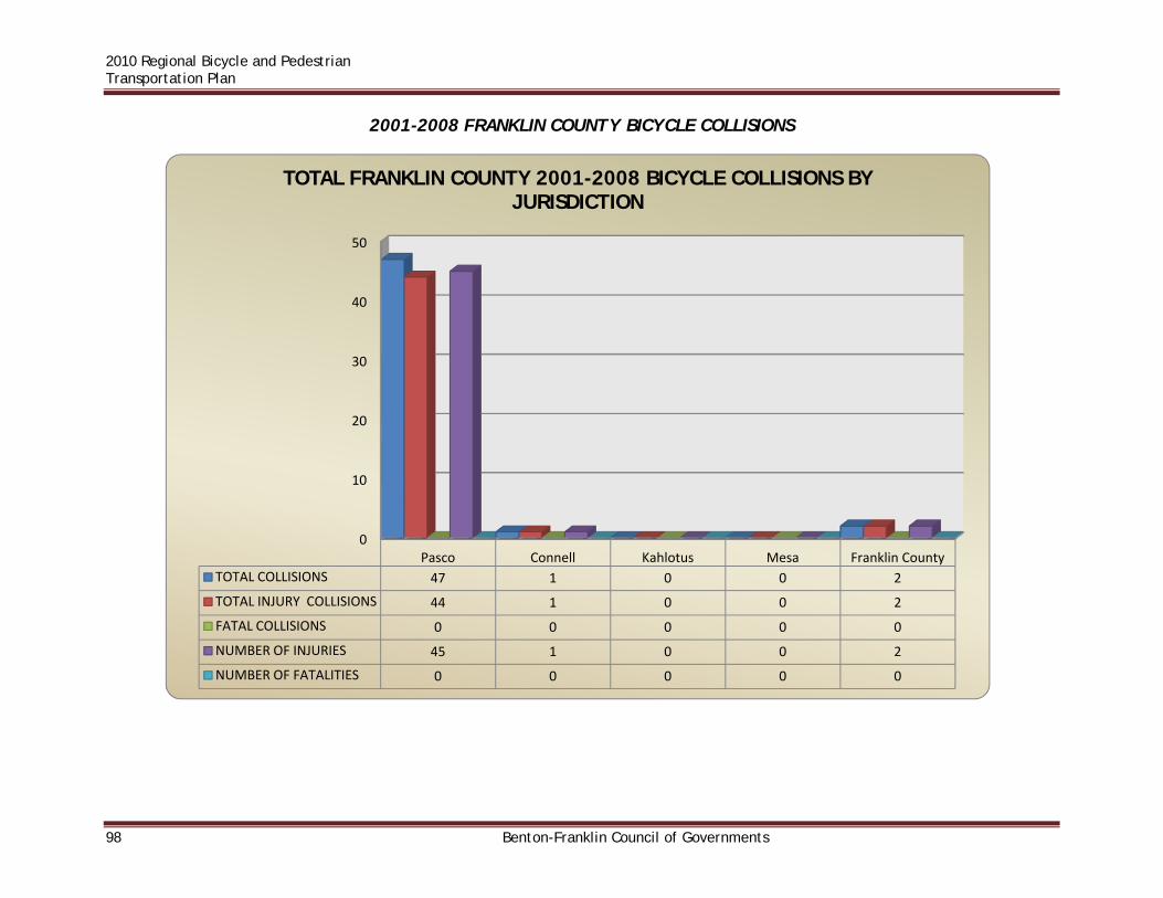
2010 Regional Bicycle and Pedestrian Transportation Plan
98 Benton-Franklin Council of Governments
2001-2008 FRANKLIN COUNTY BICYCLE COLLISIONS
0
10
20
30
40
50
Pasco Connell Kahlotus Mesa Franklin County
TOTAL COLLISIONS 47 1 0 0 2
TOTAL INJURY COLLISIONS 44 1 0 0 2
FATAL COLLISIONS 0 0 0 0 0
NUMBER OF INJURIES 45 1 0 0 2
NUMBER OF FATALITIES 0 0 0 0 0
TOTAL FRANKLIN COUNTY 2001-2008 BICYCLE COLLISIONS BY JURISDICTION

2010 Regional Bicycle and Pedestrian Transportation Plan
Benton-Franklin Council of Governments 99
0 5 10
2001
2002
2003
2004
2005
2006
2007
2008
TOTAL FRANKLIN COUNTY 2001-2008 BICYCLE COLLISIONS
NUMBER OF FATALITIES
NUMBER OF INJURIES
FATAL COLLISIONS
TOTAL INJURY COLLISIONS
TOTAL COLLISIONS

2010 Regional Bicycle and Pedestrian Transportation Plan
100 Benton-Franklin Council of Governments
2001-2008 FRANKLIN COUNTY PEDESTRIAN COLLISIONS
0
10
20
30
40
50
60
Pasco Connell Kahlotus Mesa Franklin County
TOTAL COLLISIONS 58 2 0 1 1
TOTAL INJURY COLLISIONS 54 2 0 0 1
FATAL COLLISIONS 3 0 0 1 0
NUMBER OF INJURIES 57 4 0 0 1
NUMBER OF FATALITIES 3 0 0 1 0
TOTAL FRANKLIN COUNTY 2001‐2008 PEDESTRIAN COLLISIONS BY JURISDICTION
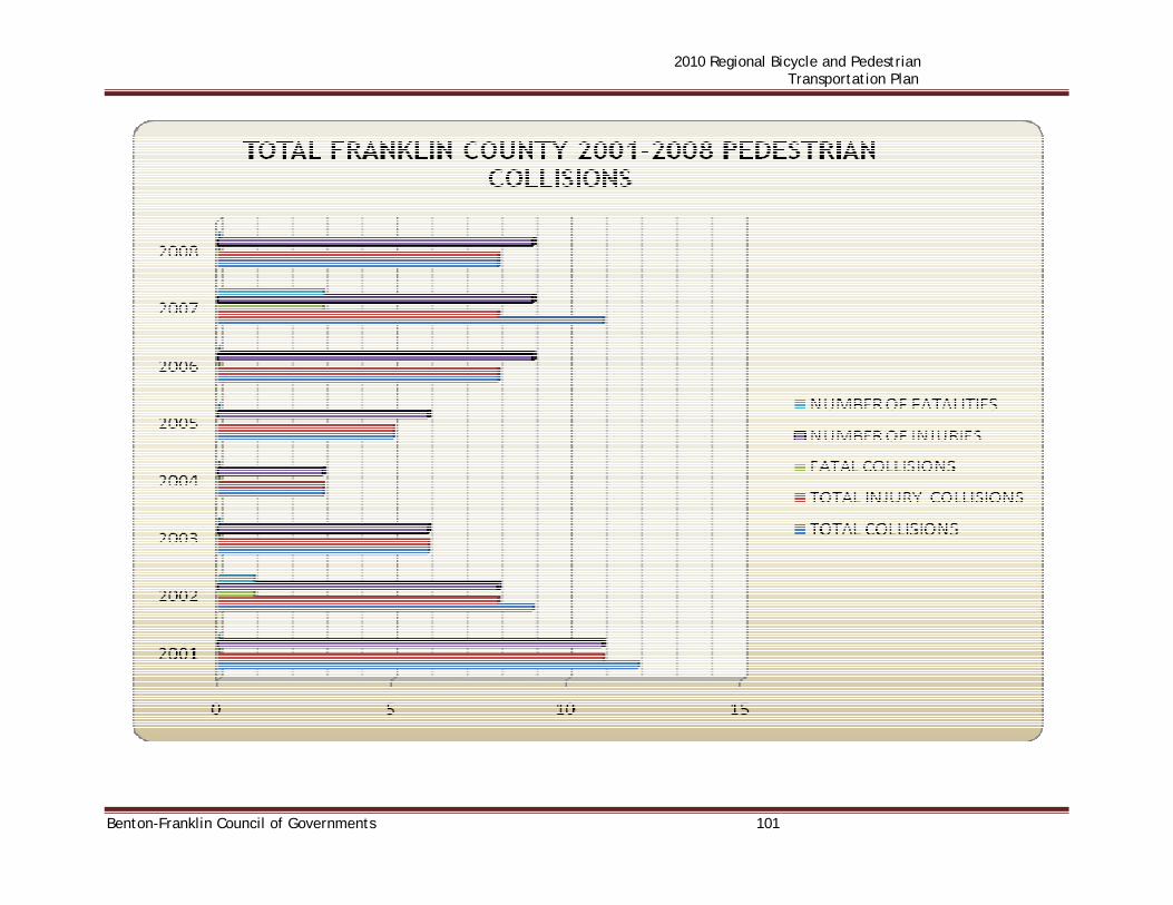
2010 Regional Bicycle and Pedestrian Transportation Plan
Benton-Franklin Council of Governments 101

2010 Regional Bicycle and Pedestrian Transportation Plan
102 Benton-Franklin Council of Governments
2001-2008 WALLA WALLA COUNTY BICYCLE COLLISIONS

2010 Regional Bicycle and Pedestrian Transportation Plan
Benton-Franklin Council of Governments 103

2010 Regional Bicycle and Pedestrian Transportation Plan
104 Benton-Franklin Council of Governments
2001-2008 WALLA WALLA COUNTY PEDESTRIAN COLLISIONS

2010 Regional Bicycle and Pedestrian Transportation Plan
Benton-Franklin Council of Governments 105
0 5 10 15 20
2001
2002
2003
2004
2005
2006
2007
2008
TOTAL WALLA WALLA COUNTY 2001-2008 PEDESTRIAN COLLISIONS
NUMBER OF FATALITIES
NUMBER OF INJURIES
FATAL COLLISIONS
TOTAL INJURY COLLISIONS
TOTAL COLLISIONS

2010 Regional Bicycle and Pedestrian Transportation Plan
106 Benton-Franklin Council of Governments
OTHER PROJECTS This section provides background information on three trail-related planning efforts in the RTPO - the Sacagawea Heritage Trail, the Tapteal Greenway Association and the Mill Creek Trail.
SACAGAWEA HERITAGE TRAIL
The Sacagawea Heritage Trail is a recreational and educational trail along twenty-two miles of Columbia River shoreline in Tri-Cities, Washington. The trail is dedicated to the lone woman on the Lewis and Clark expedition. The bi-modal trail and all trail amenities enable able bodied and disabled outdoor enthusiasts to experience an environmentally sound and unique shrub-steppe habitat and gain a greater awareness and appreciation for the experiences of Lewis & Clark’s Corps of Discovery in the Mid-Columbia region. The Sacagawea Heritage Trail Master Plan illustrates a vision for a continuous bicycle and pedestrian route connecting the Tri-Cities. The plan, showcasing interpretive opportunities, is intended to create an amenity for both local residents and visitors to the area. The nearly completed plan creates non-motorized loop routes along the riverfronts in the Tri-Cities area, and creates linkages with waterfront parks. Most of these improvements are currently in place, while other segments require design and construction. The planned trail system includes Class I multi-purpose trails, sidewalks, Class II bike routes (striped bike lanes) and Class III bike routes (signed bike routes). The Tri-Cities area is fortunate to have extensive river frontage along the Columbia, Yakima and Snake Rivers. Much of the riverfront is in public ownership, either through the Army Corps of Engineers, Cities, Benton and Franklin Counties, Port districts or State Parks. Portions of the trail route have been developed through parks, and along levees and streets. Individual jurisdictions have also completed, or are working on, trail improvements in conjunction with other waterfront development. The intent of the Master Plan was to provide a cohesive plan, with the goal of creating a complete waterfront trail system, which helps to guide local planning and design work. Standards for construction and maintenance are also an important element of the plan. In effort to stimulate completion of missing segments, upgrading of substandard segments, and cohesive planning and promotion of river shore development in general, a consultant study was initiated in 1999. Creation of the Master Plan involved input from a number of local jurisdictions, including: the Cities of Kennewick, Pasco and Richland; Benton and Franklin Counties; and the Ports of Benton, Kennewick and Pasco. Overall coordination for the planning process was provided by the Tri-Cities Visitor and Convention Bureau. An Interlocal Staff Committee composed of representatives from each of the above agencies and jurisdictions met with a consultant team to review and discuss existing conditions and proposed planning elements. The planning process began in December, 1999, and was completed in August, 2000. All participating entities have since adopted the resultant Master Plan, Sacagawea Heritage Trail, dated August 2000. The Sacagawea Heritage Trail (formerly Rivershore Loop Trail) traverses both sides of the

2010 Regional Bicycle and Pedestrian Transportation Plan
Benton-Franklin Council of Governments 107
Columbia River from the I-182 bridges at Richland to the SR 397 Cable Bridge between Kennewick and Pasco. One of the purposes of the Master Plan was to coordinate the ideas relating to riverfront trails from different plans. Many high quality park and trail planning documents have been produced for various jurisdictions within the Tri-Cities area. These include plans dating back to the McNary Master Plans from the early 1980s, to recent area plans for the Chamna Preserve and Wye Area. Some of those focus specifically on the water front, while others concern related upland areas. The Master Plan is intended to lend consistency within the Sacagawea Heritage Trail Corridor, acting as a planning reference, while remaining compatible with each participating jurisdiction’s comprehensive plan in-force at the time of the Plan’s completion.
The goals of the Sacagawea Heritage Trail plan are: Promote cooperation among jurisdictions Provide trail continuity Enhance connections with upland areas and create links with parks, civic and cultural
activities Encourage regulators and developers of adjacent private property to enhance
connections, buffers, etc. Promote safety through quality, consistency and appropriateness of design, construction
and maintenance Increase visibility of the Trail and the rivers within all communities Facilitate way-finding Protect and interpret cultural, historical and natural resources Design for environmental sustainability Plan affordable improvements Enhance accessibility (ADA) Plan for regulatory approval Maintain flood control Enhance livability Enhance economic vitality Generate financial support for proposed improvements Promote tourism Included in the Master Plan is a list of interpretive topics which could be portrayed along the route. This list includes a variety of natural, historical and cultural topics with an emphasis on specific sites of local interest. This list could be expanded if other appropriate topics come to light. It is anticipated that these displays would be of interest both to locals interested in preserving the local heritage, and to tourists learning about the area. The actual interpretive displays might take a number of forms, from signage to sculptural elements. Interpretive displays can add substantially to the enjoyment of trail facilities by the public. The Master Plan provides guidance on the creation of a waterfront trail system within the Tri-Cities area. With adoption of the Master Plan the challenge is funding and constructing the missing elements within the trail system. The completed trail system, including interpretive components, connections with upland areas, connections with other local trails, and loop routes, promises to be a significant amenity of local and regional importance. Significant portions of the improvements already exist, but there remains important work to accomplish. With a trail system such as the Sacagawea Heritage Trail, containing loop routes and linking

2010 Regional Bicycle and Pedestrian Transportation Plan
108 Benton-Franklin Council of Governments
waterfront parks, completion of each new segment greatly enhances the utility of the whole system. The Trail was completed in September 2008, and in 2009 was awarded the Governor’s Smart Communities Award for creating livable communities. The trail is subject to enhancement. In April 2010 the City of Pasco initiated the process to lower a 1.2-mile portion of the levee and reconstruct that portion of the trail with wider shoulders. However a subsequent assessment by the Corps of Engineers restricted alterations of Columbia River levees until they could be studied further. This phase of Trail development is on hold pending a Corps of Engineers decision.

2010 Regional Bicycle and Pedestrian Transportation Plan
Benton-Franklin Council of Governments 109
Map 19 – Sacagawea Heritage Trail

2010 Regional Bicycle and Pedestrian Transportation Plan
110 Benton-Franklin Council of Governments
THE TAPTEAL GREENWAY A greenway is a corridor of open space that connects people with wildlife habitat and historic areas. Greenways often follow watercourses, abandoned rail lines, or roads. The Tapteal Greenway is the 30-mile corridor along and including the Yakima River extending from Kiona Bend at Benton City to the mouth of the river at Bateman Island in Richland. This corridor includes a complex mix of federal, state, county, municipal, and private ownerships as well as a variety of habitats ranging from arid shrub-steppe to lush emergent marshlands. The Yakima River and watershed is recognized as one of the most diverse, scenic, and biologically productive systems in the entire Pacific Northwest. The Tapteal Greenway Association is a 501(c)3 non-profit organization founded in 1995 with the missions of preserving the rustic character of the lower Yakima River, protecting native habitats and species through conservation, enhancing recreational opportunities throughout the corridor, providing outdoor education programs, and promoting public access to and understanding of these resources. The Association operates through two primary channels -- development of public policy through work with local governments, and on-the-ground enhancement activities such as clean-ups, trail-building, and habitat restoration. The Tapteal Greenway Association is a 100% volunteer organization driven by the Membership and the Board of Directors and funded solely by member dues, donations, and grants. The Greenway employs no staff and has no endowment. The terms "Tapteal Greenway" and "Greenway" refer to both the organization and the corridor, depending on context of use. The Greenway is responsible for or has participated in multiple accomplishments, both completed and ongoing, including: sponsorship and participation in local educational events; building and maintaining trails and boat launches; shoreline master planning; and construction and maintenance of kiosks and signage. The Tapteal Greenway Association has a proposed greenway plan along the Yakima River from Richland to Benton City. A major element of that plan is a multi-use trail system from Columbia Point to the western terminus of the Benton City/Kiona Irrigation District Trail. Though both the Sacagawea Heritage Trail and the Tapteal Greenway have recreational and educational elements in their makeup, each has potential as a commute route for bicyclists as well.

2010 Regional Bicycle and Pedestrian Transportation Plan
Benton-Franklin Council of Governments 111

2010 Regional Bicycle and Pedestrian Transportation Plan
112 Benton-Franklin Council of Governments
THE MILL CREEK TRAIL SYSTEM
Mill Creek Recreation Trail System is a joint effort between the City of Walla Walla, Walla Walla County, Walla Walla Community College, and Army Corps of Engineers. The 3.8 miles of paved trails connects Eastgate Lyons Park, Mill Creek Sports Complex, Walla Walla Community College, Lake Bennington Recreation Area and Rooks Park. The majority of the trail runs along Mill Creek with spur trails to the parks and college.
Lake Bennington Recreation Area and Rooks Park are US Army Corps of Engineers facilities (USACE). Bennington Lake is available year round for boating, fishing, hiking, picnicking or just walking in the scenic open spaces. Nearby Rooks Park is open from 7:00 a.m. to Sunset daily. Information and recreation map of the area can be found at http://www.nww.usace.army.mil/corpsoutdoors/mcl/MCRECTR.HTM

2010 Regional Bicycle and Pedestrian Transportation Plan
Benton-Franklin Council of Governments 113

2010 Regional Bicycle and Pedestrian Transportation Plan
114 Benton-Franklin Council of Governments
BICYCLE- PEDESTRIAN WORKSHOPS Workshops to identify bicycle and pedestrian issues were held in College Place (October 13, 2009) and in Richland (October 15, 2009). At each workshop, attendees were asked to review maps of local jurisdictions’ street systems and identify specific locations which were problematic for users. The second part of each meeting involved a presentation by of the major issues identified for each city. The third part of each meeting was issue prioritization. This section of the plan summarizes each workshop and presents the prioritized issues by jurisdiction. Jurisdictions were given the opportunity to comment on any issue within their boundary. Those comments are also included. College Place Workshop A workshop for the update to the Regional Bicycle-Pedestrian Plan was held in College Place City Hall on October 13th, 2009. Its purpose was identification and discussion of bicycle and pedestrian issues in the Walla Walla/College Place Urban Area. Nearly a dozen members of the public attended. The open house was divided into the three parts outlined above. The first part involved dividing the attendees into two groups, which broke out to separate tables and reviewed maps of local jurisdictions’ street systems to outline corridors they used as cyclists and identify specific locations which were problematic for users. Maps reviewed included the cities of Walla Walla and College Place and Walla Walla County surrounding the urban area. The second part of the meeting involved a presentation of the major issues identified for each city. As the presentations were made, each issue was noted on a large tablet. For the third part of meeting, was issues prioritization maps and issues for each city were separated out and each participant was given red dots to vote for the issues they identified as most critical for each jurisdiction. The participants were instructed to vote for their top three issues/challenges for each jurisdiction. The issue lists were prioritized and sent to each jurisdiction to give them the opportunity to comment on them. The comments are included after the issue discussion. The corridors of use identified by the attendees are shown on each jurisdiction’s system map in the section titled Plans, Policies, Regulations and Practices. A listing of maps is on Page iii at the front of this document. These corridors could be used by individual jurisdictions in conjunction with meetings with local bicyclists to identify potential projects in each corridor, such as improved crossings, additional signage, or smoothing of road surfaces.

2010 Regional Bicycle and Pedestrian Transportation Plan
Benton-Franklin Council of Governments 115
ISSUE DISCUSSION College Place The top issues, as identified by the meeting attendees, for College Place include:
1. Rose Street – no bike lanes/need coordinated road speeds 2. Intersection of College Ave. and Rose Street – on-street parking 3. Crossing Myra Road 4. Intersection of Larch Avenue and Whitman Drive
Issue 1:Rose Street – no bike lanes/need coordinated road speeds Downtown Walla Walla to North College Avenue: Challenges identified include poor overall road condition; absence of bike lanes; and need to coordinate road speed with Walla Walla. The segment of corridor most in need of attention is Myra Road to 13th Avenue. Issue 2: Intersection of College Ave. and Rose Street on street parking On street parking south of the intersection is difficult for cyclists to travel past. Issue 3: Crossing Myra Road Identified issues include the lack of a safe and secure crossing of Myra Road into Fort Walla Walla Park; as well as crossing on SE 12th Street and at Garrison Creek; and development of a trail along Garrison Creek. A trail along Garrison Creek would be a private, not a public development. Such a trail is not part of the city’s bike plan. Issue 4: Intersection of Larch Avenue and Whitman Drive The intersection of Larch Avenue and Whitman Drive is a chokepoint. Walla Walla The top issues, as identified by the meeting attendees, for Walla Walla include:
1. Rose Street: Downtown Walla Walla to North College Avenue - no bike lanes/need coordinated road speeds
2. Tietan Street Cooridor from Plaza Way to Fern Avenue 3. Intersection of 3rd Avenue and Tietan Street 4. Walla Walla Commercial District/Walla Walla Community College 5. Chestnut Street Corridor
2010 Regional Bicycle and Pedestrian Transportation Plan
116 Benton-Franklin Council of Governments
Issue 1:Rose Street – no bike lanes/need coordinated road speeds Downtown Walla Walla to North College Avenue: Issues identified include poor overall road condition; absence of bike lanes; and need to coordinate road speed with College Place. The segment of corridor most in need of attention is Myra Road to 13th Avenue. Issue 2: Tietan Street Corridor from Plaza Way to Fern Avenue Issues include bicycle access at all intersections along corridor and absence of bike lanes. Issue 3: Intersection of 3rd Avenue and Tietan Street Issues include: inadequate bike lane striping; interference from dedicated turn lanes; high traffic in both directions though only the north/south bound traffic is compelled to stop; safety issues for students from Garrison Middle School; and traffic interference from the fairgrounds. Issue 4: Walla Walla Commercial District/ Walla Walla Community College The primary issue is the presence of three high-traffic intersections (Boyer Ave from Palouse Street to Wilbur Ave/Mill Creek Trail) that are very unfriendly to bicycle traffic. The condition of Mill Creek Trail in general is an additional issue. Issue 5: Chestnut Street Corridor Chestnut Street from 12th Avenue to Howard Street. Issues identified include the presence of on-street parking coupled with the already narrow street; safety of Paine Elementary students; lack of an identified/accepted route through Veterans Medical Center grounds; and lack of a developed trail through Fort Walla Walla Park. Walla Walla County The top issues, as identified by the meeting attendees, for Walla Walla County include:
1. Mill Creek Road Corridor 2. Mojonnier Road – Frog Hollow to South College Avenue 3. Cotton Wood Road – Canberra Drive to Langdon Road 4. Intersection of US 12 and Sapolil Road
Issue 1: Mill Creek Road Corridor Issues identified include inadequate shoulders for at least five miles and vehicle speeds along the road

2010 Regional Bicycle and Pedestrian Transportation Plan
Benton-Franklin Council of Governments 117
Issue 2: Mojonnier Road – Frog Hollow to South College Avenue The identified issue is the lack of shoulders. Issue 3: Cotton Wood Road – Canberra Drive to Langdon Road The issue is the narrow width of the road. Issue 4: Intersection of US 12 and Sapolil Road The issue is the removal of the shoulders by WSDOT. WSDOT The top issues, as identified by the meeting attendees, for Walla Walla County include:
1. Intersection of US 12 and Sapolil Road Issue 1: Intersection of US 12 and Sapolil Road The issue is the removal of the shoulders by WSDOT. Waitsburg and Prescott Waitsburg and Prescott were also discussed by at the meeting. However, there was no group discussion/presentation or voting on issues concerning these jurisdictions. Issues raised concerning those jurisdictions are identified in the list below.
BICYCLE-PEDESTRIAN OPEN HOUSE ISSUE IDENTIFICATION/PRIORITIZATION
Rank Location Issue Votes
College Place
1 Rose Street (Downtown Walla Walla to North College Avenue)
Poor road condition, no bike lanes, consistent vehicle speed limit 10
2 Intersection of College Avenue and Rose Street On-street parking south of intersection 3
2 Crossing Myra Road (Fort Walla Walla/12th St/Garrison Creek) Lack of safe crossings 3
4 Intersection of Larch Avenue and Whitman Drive Chokepoint for non-motorized traffic flow 1
Walla Walla
1 Rose Street (Downtown Walla Walla to North College Avenue)
Poor road condition, no bike lanes, consistent vehicle speed limit 10

2010 Regional Bicycle and Pedestrian Transportation Plan
118 Benton-Franklin Council of Governments
2 Tietan Street Corridor (Plaza Way to Fern Ave) Lack of bike lanes/bike access at intersections 6
3 Intersection of 3rd Ave and Tietan Street Inadequate bike lane striping, traffic interference 5
4 Commercial District/Community College Intersections are not bicycle friendly 3
4 Chestnut Street Corridor (12th Ave to Howard Street) On-street parking/narrow street 3
Walla Walla County
1 Mill Creek Road Corridor Lack of shoulders for 5 mile segment 7
2 Mojonnier Road (Frog Hollow to South College Ave) Lack of shoulders 4
2 Cottonwood Road (Canberra Drive to Langdon Road) Narrow road width 4
4 Intersection of US 12 and Sapolil Road WSDOT removed the shoulders 3
WSDOT
1 Intersection of US 12 and Sapolil Road WSDOT removed the shoulders 3
JURISDICTION RESPONSES The Issue Identification/Prioritization List was distributed to jurisdictions for their review and comment. Comments received are below. College Place - No response Walla Walla - No response Walla Walla County Mill Creek Road Corridor Walla Walla County is currently seeking funding to widen a portion of Mill Creek Road. Tri-Cities Workshop A workshop for the update to the Regional Bicycle-Pedestrian Plan was held on October 15th
2009. More than 25 members of the public attended. The open house was divided into three parts as described earlier. The first part involved dividing the attendees into four groups. The groups broke out to separate tables and reviewed maps of local jurisdictions’ street systems to outline corridors they used as cyclists and identify specific locations which were problematic for users. Maps reviewed included the cities of Kennewick, Pasco, Richland, West Richland, Benton City and Prosser, and Benton and Franklin Counties. The second part of the meeting involved a presentation of the major issues identified for each city. As the presentations were made, each issue was noted on a large tablet. Due to time constraints, identification of critical issues only covered the four metropolitan area
2010 Regional Bicycle and Pedestrian Transportation Plan
Benton-Franklin Council of Governments 119
cities of Kennewick, Pasco, Richland and West Richland. For the third part of meeting, maps and issues for each city were separated out and each participant was given red dots to vote for the issues they identified as most critical for each city. Voting only took place for the four metropolitan area jurisdictions (mentioned above) subject to issue identification. The issue lists were sent to each jurisdiction to give them the opportunity to comment on them. The comments are included after the issue discussion. Some citizens were unable to attend the meeting and emailed comments about the metropolitan-area trail system. Those comments and replies are included here. ISSUE DISCUSSION Kennewick The top issues, as identified by the meeting attendees, for Kennewick include:
1. Edison Street – Columbia Park Trail to 10th Avenue has no bike lanes 2. 10th Avenue – Clodfelter Road/Hildebrand Road/ 10th Avenue Intersection (Five
Corners) to Columbia Center Boulevard is narrow and lacks shoulders
Issue 1: Edison Street – Columbia Park Trail to 10th Avenue This portion of Edison lacks much needed bike lanes. Issue 2: 10th Avenue – Clodfelter Road/Hildebrand Road/ 10th Avenue Intersection (Five Corners) to Columbia Center Boulevard This portion of 10th Avenue is too narrow and lacks wide enough shoulders or bike lanes. Richland The top issues, as identified by the meeting attendees, for Richland include:
1. Bike Path along 240 (Stevens/240 to Twin Bridges Road/Benton City) 2. GWW signage/Bike lane on Lee/Swift/Williams 3. Fence along pathway between I-182 bridge and Yakima River
Issue 1: Bike Path along SR240 (Stevens/240 to Twin Bridges Road/Benton City) Develop a bike path along SR 240 from the Stevens Drive/ SR 240 intersection to Twin Bridges Road or Benton City turn off Issue 2: GWW signage/Bike lane on Lee/Swift/Williams Improve signage along George Washington Way identifying and directing bike riders toward the Columbia River Trail, as well as improved access and signage to the Columbia River Trail

2010 Regional Bicycle and Pedestrian Transportation Plan
120 Benton-Franklin Council of Governments
(possibly a bike lane on one or more streets) along Lee Boulevard, Swift Boulevard and Williams Boulevard Issue 3: Fence along pathway between I-182 bridge and Yakima River Add a fence adjacent to the pathway leading to SR 240 in the Columbia Point area to separate the bike trail from the preserve area by fencing it off for the entire distance from the entrance at the I-182 bridge to the Yakima River. The issue is safe access to and from the bike path between the Columbia Point parking lot and the SR-240 side path. Pasco The top issues, as identified by the meeting attendees, for Pasco are:
1. Pedestrian and bicycle access over/across I-182 in the vicinity of Road 84 2. Sacagawea Heritage Trail (Blue Bridge to Road 100) widening/resurfacing/
maintenance
Issue 1: Pedestrian and bicycle access over/across I-182 in the vicinity of Road 84 There is a need for safe bicycle and pedestrian crossing of I-182 near Road 84. Issue 2: Sacagawea Heritage Trail (Blue Bridge to Road 100) widening/resurfacing/ maintenance From Road 52 west to Court Street the trail needs to be widened to support multiple uses. Additionally, segments of the trail surface in this area are cracked and should be patched or resurfaced. In general the trail is in need of more regular maintenance to control tack weed and goose droppings. Benton County The top issues for Benton County include:
1. Badger Road 2. Clodfelter Road
Issue 1: Badger Road – Improve shoulders from Webber Canyon Road to Leslie Road Improve shoulders from Webber Canyon Road to Leslie Road. Issue 2: Clodfelter Road – Widen shoulders from Plymouth Road to Clearwater Avenue Widen shoulders from Plymouth Road to Clearwater Avenue. Washington State Department of Transportation Although WSDOT was not a focus of discussion at the meeting, a few of the issues discussed are their responsibility. Three of those issues, as identified by the meeting attendees, are listed below.
2010 Regional Bicycle and Pedestrian Transportation Plan
Benton-Franklin Council of Governments 121
1. SR 240 Bike Path (Stevens to Twin Bridges Road) 2. Chip seal on SR 240 3. SR 224 from SR 240 to West Richland (bike lane signage/regular maintenance)
Issue 1: SR 240 Bike Path (Stevens to Twin Bridges Road)
SR 240 now has 8’ shoulders from Stevens Drive to SR 225, except at intersections where it narrows to 4’. Bicycles and pedestrians are allowed to use the shoulder. If a separated bike/ped path is requested, WSDOT is willing to work with others to see what can be done to get it approved. Currently WSDOT has no funding available to help with this project.
Issue 2: Chip seal on SR 240
To provide a smoother shoulder, the roadway should be overlaid or converted to HMA. Currently, this section of SR 240 does not meet WSDOT’s requirements for HMA. It is not scheduled or funded for additional preservation work.
Issue 3: SR 224 from SR 240 to West Richland (bike lane signage/regular maintenance)
Normally the shoulder is swept at the request of the public. There is no sweeping or other regularly scheduled maintenance of the shoulder. Bikes are allowed on the shoulder if they follow the “rules of the road”. There is no plan to add a bike lane or signing at this time.
Franklin County
1. Columbia Plateau Trail Issue 1: Columbia Plateau Trail Complete the Columbia Plateau Trail. Tri-Cities Area
1. Sign safe routes to schools and libraries Issue 1: Sign safe routes to schools and libraries There is a lack of proper facilities and signage for bicycles and pedestrians around public schools and libraries in the area. Adequate sidewalks and bike paths and separated bike lanes should be provided. Hanford Area Issues identified in the Hanford Area were:
1. Fast Flux Test Facility Road

2010 Regional Bicycle and Pedestrian Transportation Plan
122 Benton-Franklin Council of Governments
Issue 1: Fast Flux Test Facility Road This road should be reopened for bicycle use. Benton City, Prosser and West Richland Benton City, Prosser and West Richland were also discussed by at the meeting. However, there was no group discussion/presentation or voting on issues concerning these jurisdictions. Issues raised concerning those jurisdictions are identified in the list below.
TRI-CITIES BICYCLE-PEDESTRIAN OPEN HOUSE ISSUE IDENTIFICATION/PRIORITIZATION
Rank Location Issue Votes
Kennewick
1 Edison Street – Columbia Park Trail to 10th Avenue No bike lanes 8
2 10th Avenue – (Five Corners) to Columbia Center Boulevard Narrow/lacks shoulders 5
3 Columbia Park Trail No bike-ped trail, the road surface and shoulder are rough 3
3 RR ROW Bellerive Drive to Columbia Center Boulevard Complete the Richland-Kennewick railroad right-of-way bike/ped path 3
5 US 395/Ridgeline Drive intersection Needs a traffic signal 2
5 Canal Drive – Columbia Center Boulevard to Edison Street Needs bike lanes and striping 2
7 10th Avenue Has bike lane gaps at intersections 0
7 Develop a Safe Routes to School Program Develop a Safe Routes to School Program 0
Pasco
1 I-182 in the vicinity of Road 84 Pedestrian and bicycle access over/across 6
2 Sacagawea Heritage Trail (Road 52 west to Court Street)
Needs to be widened to support multiple uses 4
3 Argent Road from Road 68 to Road 48 Needs wider shoulders 3
4 Road 68 from Court Street to Sandifur Parkway Lacks bike lanes and is unsafe 2
4 Harris Road from West Court Street to Broadmoor Boulevard
Needs wider shoulders and bike signage 2
6 Argent Road from 20th Avenue to 4th Avenue Needs wider shoulders or a bike lane 1
6 Neighborhoods near the Sacagawea Heritage Trail Signage indicating access to, and location of, the trail 1
7 Intersection of Harris Road/Broadmoor Boulevard/Sandifur Parkway
Unsafe and confusing and needs to be redesigned 0
7 4th Avenue from Argent Road to Lewis Street Needs bike lanes and striping 0
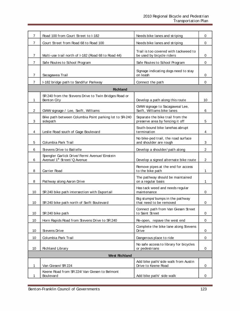
2010 Regional Bicycle and Pedestrian Transportation Plan
Benton-Franklin Council of Governments 123
7 Road 100 from Court Street to I-182 Needs bike lanes and striping 0
7 Court Street from Road 68 to Road 100 Needs bike lanes and striping 0
7 Multi-use trail north of I-182 (Road 68 to Road 44) Trail is too covered with tackweed to be used by bicycle riders 0
7 Safe Routes to School Program Safe Routes to School Program 0
7 Sacagawea Trail Signage indicating dogs need to stay on leash 0
7 I-182 bridge path to Sandifur Parkway Connect the path 0
Richland
1 SR 240 from the Stevens Drive to Twin Bridges Road or Benton City Develop a path along this route 10
2 GWW signage / Lee, Swift, Williams GWW signage to Sacagawea/Lee, Swift, Williams bike lanes 6
3 Bike path between Columbia Point parking lot to SR-240 sidepath
Separate the bike trail from the preserve area by fencing it off 5
4 Leslie Road south of Gage Boulevard South-bound bike lanehas abrupt termination 4
5 Columbia Park Trail No bike-ped trail, the road surface and shoulder are rough 3
6 Stevens Drive to Battelle Develop a shoulder/path along 2
6 Spengler Garlick Drive/Fermi Avenue/Einstein Avenue/1st Street/Q Avenue Develop a signed alternate bike route 2
8 Carrier Road Remove pipes at the end for access to the bike path 1
8 Pathway along Aaron Drive The pathway should be maintained on a regular basis 1
10 SR 240 bike path intersection with Duportail Has tack weed and needs regular maintenance 0
10 SR 240 bike path north of Swift Boulevard Big stumps/bumps in the pathway that need to be removed 0
10 SR 240 bike path Connect path from Van Giesen Street to Saint Street 0
10 Horn Rapids Road from Stevens Drive to SR 240 Re-open, repave the west end 0
10 Stevens Drive Complete the bike lane along Stevens Drive 0
10 Columbia Park Trail Dangerous place to ride 0
10 Richland Library No safe access to library for bicycles or pedestrians 0
West Richland
1 Van Giesen/SR 224 Add bike path/side walk from Austin Drive to Keene Road 0
1 Keene Road from SR 224/Van Giesen to Belmont Boulevard Add bike path/ side walk 0
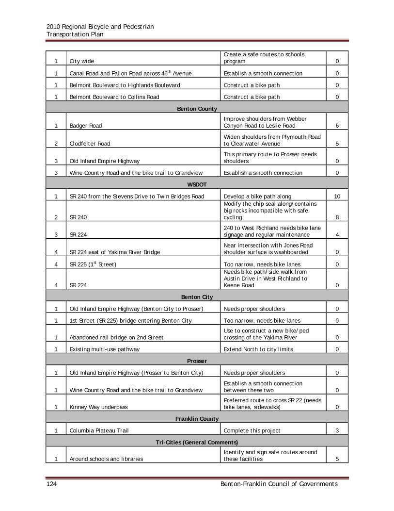
2010 Regional Bicycle and Pedestrian Transportation Plan
124 Benton-Franklin Council of Governments
1 City wide Create a safe routes to schools program 0
1 Canal Road and Fallon Road across 46th Avenue Establish a smooth connection 0
1 Belmont Boulevard to Highlands Boulevard Construct a bike path 0
1 Belmont Boulevard to Collins Road Construct a bike path 0
Benton County
1 Badger Road Improve shoulders from Webber Canyon Road to Leslie Road 6
2 Clodfelter Road Widen shoulders from Plymouth Road to Clearwater Avenue 5
3 Old Inland Empire Highway This primary route to Prosser needs shoulders 0
3 Wine Country Road and the bike trail to Grandview Establish a smooth connection 0
WSDOT
1 SR 240 from the Stevens Drive to Twin Bridges Road Develop a bike path along 10
2 SR 240
Modify the chip seal along/contains big rocks incompatible with safe cycling 8
3 SR 224 240 to West Richland needs bike lane signage and regular maintenance 4
4 SR 224 east of Yakima River Bridge Near intersection with Jones Road shoulder surface is washboarded 0
4 SR 225 (1st Street) Too narrow, needs bike lanes 0
4 SR 224
Needs bike path/side walk from Austin Drive in West Richland to Keene Road 0
Benton City
1 Old Inland Empire Highway (Benton City to Prosser) Needs proper shoulders 0
1 1st Street (SR 225) bridge entering Benton City Too narrow, needs bike lanes 0
1 Abandoned rail bridge on 2nd Street Use to construct a new bike/ped crossing of the Yakima River 0
1 Existing multi-use pathway Extend North to city limits 0
Prosser
1 Old Inland Empire Highway (Prosser to Benton City) Needs proper shoulders 0
1 Wine Country Road and the bike trail to Grandview Establish a smooth connection between these two 0
1 Kinney Way underpass Preferred route to cross SR 22 (needs bike lanes, sidewalks) 0
Franklin County
1 Columbia Plateau Trail Complete this project 3
Tri-Cities (General Comments)
1 Around schools and libraries Identify and sign safe routes around these facilities 5

2010 Regional Bicycle and Pedestrian Transportation Plan
Benton-Franklin Council of Governments 125
2 Sacagawea Heritage Trail Cities should install wayfinding signage towards the trail 3
2 Chip seal rock type Avoid large rock in chip seal process 3
4 Trail maintenance Lanes and trails should be swept, cracks filled, tack weed cleared…etc. 2
Hanford Area
1 Fast Flux Test Facility Road needs to be reopened 3
2 Route 10 Expansion joints on Route 10 need replacing 0
Note: The above issues in Benton City, Prosser, and West Richland were not prioritized. JURISDICTION RESPONSES The Issue Identification/Prioritization List was distributed to jurisdictions for their review and comment. Comments received are below. Kennewick Edison Street – Columbia Park Trail to 10th Avenue has no bike lanes. Eight votes
The city has a project in design to widen Edison between the south end of the Kamiakin High School property to just north of Metaline (east side). This project will include addition of bicycle lanes. The city will continue to look for grant opportunities to widen Edison both north to Canal and south to Clearwater.
10th Avenue – Clodfelter Road/Hildebrand Road/10th Avenue Intersection (Five Corners) to Columbia Center Boulevard is narrow and lacks shoulders. Five votes
The City is working with developers to start construction of a reconstructed street. The first phase will not include bicycle lanes, but ultimately, the road is planned to be three lanes with bike lanes and sidewalks from 5-corners to Columbia Center Boulevard. This project is realistically 3-5 years out depending on the rate of development.
Columbia Park Trail has no bike-ped trail, the road surface and shoulder are rough. This issue is listed in both Richland and Kennewick. Three votes
The outside vehicle lanes between Edison Street and the golf course have been freshly chip sealed and restriped and signed to be bicycle lanes. It is unlikely that anything other than spot repairs will be affordable for these lanes anytime in the near future.
Complete the Richland-Kennewick railroad right-of-way bike/ped path from Bellerive Drive to Columbia Center Boulevard. Three votes
The City is currently working with two properties to secure easements to extend the trail to Steptoe. Though construction funds are not yet identified, they are being pursued. East of Steptoe there are some hurdles crossing additional properties, but

2010 Regional Bicycle and Pedestrian Transportation Plan
126 Benton-Franklin Council of Governments
mostly that the City does not own the land and tracks are still in place on 90% of this length. There are on-street bicycle facilities however from Steptoe to Columbia Center Mall on Gage Boulevard.
US 395/Ridgeline Drive intersection needs a traffic signal. It is unsafe to cross. Two votes
The current downgrade of US395 and high speed are not conducive to putting in a traffic signal at this location at this time. A signal could be more dangerous to traffic without other things being done along the corridor as well. WSDOT is currently doing a corridor study along US395 through Kennewick and Pasco to look at how this corridor functions for both motorized and non-motorized traffic.
Canal Drive – Columbia Center Boulevard to Edison Street has no bike lane markings. Two votes
This segment was evaluated for consideration of bike lanes with an overlay that was performed about 3 years ago. It was determined to have insufficient width to add the bicycle lanes. A suitable alternative is Umatilla Avenue which is low volume traffic from Edison Street right up to Columbia Center Boulevard. There is also a little known connection between Umatilla/Colorado and the sidewalks on Columbia Center Boulevard (see aerial shot below).

2010 Regional Bicycle and Pedestrian Transportation Plan
Benton-Franklin Council of Governments 127
10th Avenue – Has bike lane gaps at intersections. No votes
There is no practical way to fund the widening and reconstruction of the several intersections in question. However, the City is watching the development of Sharrows, and may consider these as a supplemental treatment if and when they are approved for wide scale use. Develop a Safe Routes to Schools program. No votes Such a program would require a grant that would provide for a consultant prepared and developed program. The City will pursue grants if appropriate opportunities become available.
CITIZEN EMAILS PRIOR TO THE MEETING: Pedestrian and bicycle safety on Steptoe Street. Issues include: dearth of safe pedestrian crossing sites along Steptoe; safe access to bus stop; and the posted speed limit is too high.
Creating safe crossings on a five lane arterial like this is very challenging. It really is necessary to find a mid-block location that does not interfere with left-turn traffic to and from the side streets. The location would really need a median pedestrian refuge as well so pedestrians could make a two stage crossing, only having to deal with one direction of traffic at a time. The most logical place for such a crossing would likely be at the point where the railroad trail meets Steptoe. Unfortunately most other areas either have left-turn conflicts and/or poor sight distance due to the crest vertical curve. The speeds on Steptoe have been evaluated in the last six weeks and the current posting is still appropriate. The mean speeds are 40-41 mph while the 85th percentile speeds are at about 42-43 mph. Lowering the speed limit would have very little effect without constant enforcement and would cause all but about 20% of drivers to be disobeying the posted speed.
Missing sidewalk on Quinault Street west of Columbia Center Boulevard
The city has traditionally had land owners construct the sidewalk when developing their property. This has been very successful in general. This segment is important and will be considered in the Sidewalk Capital Improvement Program.
Pasco Issue 1: Pedestrian and bicycle access over/across I-182 in the vicinity of Road 84
There is a need for safe bicycle and pedestrian crossing of I-182 near Road 84. This overpass/tunnel was deemed unfeasible by the group. An overpass would be prohibitively expensive; an underpass/tunnel would be a maintenance nightmare.
Issue 2: Sacagawea Heritage Trail (Blue Bridge to Road 100) widening/resurfacing/ maintenance
From Road 52 west to Court Street the trail needs to be widened to support multiple

2010 Regional Bicycle and Pedestrian Transportation Plan
128 Benton-Franklin Council of Governments
uses. Additionally, segments of the trail surface in this area are cracked and should be patched or resurfaced. In general the trail is in need of more regular maintenance to control tack weed and goose droppings. This project is on the top of Pasco’s to-do list, pending Army Corps action.
Sacagawea Heritage Trail Phase 2 This project has been completed. Argent Road from Road 68 to Road 48 Needs wider shoulders:
Most of this is in the County and will not be addressed by the City prior to annexation. Road 68 from Court Street to Sandifur Parkway Lacks bike lanes and is unsafe: This is also County jurisdiction. However the City has plans to widen and enhance this section post-annexation. As well, the City will consider a “Bike/Ped friendly” Road 68/I-182 Overpass a long-term State project priority.
Harris Road from West Court Street to Broadmoor Boulevard Needs wider shoulders and bike signage:
Harris road will be enhanced by Central Pre-Mix as part of their Hot Asphalt Batch Plant. As well, the City may opt to re-direct Bike/Ped traffic to a separate path within the Sewer ROW along the west side of I-182.
Argent Road from 20th Avenue to 4th Avenue needs wider shoulders or a bike lane:
This section is Port of Pasco property. Enhancement of this section would of necessity be a joint Port/City project. The road bed is already wide enough to accommodate Bike/Ped enhancements so it would be a fairly simple and cost-effective project. The City considers this a good connection route between Argent Road and North 4th Avenue and an essential part of the overall North 4th Avenue enhancement project.
Signage indicating access to, and location of, the trail in neighborhoods near the Sacagawea Heritage Trail:
This is a relatively inexpensive, in-house item. One issue related to this is neighborhood acceptance to people parking in the neighborhood as a launching point for bike activities. Signage should be designed in such a way as to direct bicyclist and pedestrians only in areas without public parking areas, and cars to areas where public parking is available.
Intersection of Harris Road/Broadmoor Boulevard/Sandifur Parkway is Unsafe and confusing and needs to be redesigned:
This intersection will be funded, redesigned/redirected to Sandifur by the developer. 4th Avenue from Argent Road to Lewis Street Needs bike lanes and striping:
One half of this project is currently underway (between Court Street and the I-182

2010 Regional Bicycle and Pedestrian Transportation Plan
Benton-Franklin Council of Governments 129
interchange), however no bicycle enhancements are included in the project. Sidewalk will be added along the East side of the street from the PUD south lot line to the I-182 interchange. In the Sylvester-to-Court Streets section streets will be re-striped to single lanes with enhanced shoulder widths for safer bicycle passage. The City’s past policies did not permit true “Bike Lanes” due to the extra cost of striping/ marking/maintaining to Bike Lane standards. Current policy on this issue is pending the hiring of a new Public Works Director.
Road 100 from Court Street to I-182 Needs bike lanes and striping:
This section will receive treatment similar to the “A” Street LID, namely sidewalk on the East side and a wide bike path on the west side of Road 100 with a landscaped swale separating the road from the path.
Court Street from Road 68 to Road 100 Needs bike lanes and striping:
While this entire section has been recently enhanced with curb and gutter, The City’s past policies did not permit true “Bike Lanes” due to the extra cost of striping/ marking/maintaining to Bike Lane standards. Current policy on this issue is pending the hiring of a new Public Works Director.
Multi-use trail north of I-182 (Road 68 to Road 44) is too covered with goathead weeds to be used by bicycle riders:
This section of trail may be included in the upcoming City Parks Plan, and as such, may be eligible for park funding. As well, because the City maintains a Sewer Easement it may be able to do some enhancements as part of that easement maintenance. Finally, the east section of the trail is currently undeveloped. If these sections of trail are included in the parks plan the developers could be required to donate path property as part of their future development.
Safe Routes to School Program:
This is a federal funding program currently utilized by the City (engineering) to fund sidewalks along school walking routes.
Signage indicating dogs need to stay on leash along Sacagawea Trail:
The City has no current plans to operate this program due to the high installation and maintenance costs of canine fecal removal stations. An enhanced fines/reward system may have potential of making this program worthwhile.
Connect the path from I-182 bridge to Sandifur Parkway:
The City may create a Bike/Ped path within the Sewer ROW along the west side of I-182.
Complete the Columbia Plateau Trail project:
This is a state parks project, although the City is in favor of it and is willing to weigh

2010 Regional Bicycle and Pedestrian Transportation Plan
130 Benton-Franklin Council of Governments
in. Canal Path:
The City will build this path as the Canal District replaces open canal with underground pipes.
Richland Develop a bike path along SR 240 from the Stevens Drive/ SR 240 intersection to Twin Bridges Road or Benton City. Ten votes
This pathway was added to the City’s Transportation Plan in 2008. Improved signage along George Washington Way identifying and directing bike riders toward the Columbia River Trail, as well improved access and signage to the Columbia River Trail (possibly a bike lane on one or more streets) along Lee Boulevard, Swift Boulevard and Williams Boulevard. Six votes
The City has recently re-paved and re-striped Williams Boulevard to provide bike and parking lanes on each side of the roadway between Stevens Drive and George Washington Way. In 2010, Lee Boulevard will be reconstructed and re-striped to provide bike lanes and parking on each side of the roadway from Thayer Drive to Jadwin Avenue. The City is exploring options for re-striping and constructing a road and pathway along Swift Boulevard to the Columbia River Trail.
Add a fence adjacent to the pathway leading to SR 240 in the Columbia Point area to separate the bike trail from the preserve area by fencing it off for the entire distance from the entrance at the I-182 bridge to the Yakima River. The issue is safe access to and exit from the bike path between the Columbia Point parking lot to the SR-240 sidepath. Five votes
The path is located on WSDOT right-of-way and currently there is a fence between the path and I-182. The purpose of the fence is to keep pedestrians from access the highway. If there is a need to fence off the preserve from the path, that would be the responsibility of the preserve owner.
Leslie Road south of Gage Boulevard has an abrupt south-bound bike lane termination. This needs to be addressed. Four votes
The City of Richland is the lead agency for the Leslie Road Improvements Project which widens and reconstructs Leslie Road from Clearwater Avenue to Meadow Hills Drive. The project widens the roadway to provide two travel lanes in each direction, a center turn lane and bike lanes and sidewalks on each side of the road. The first phase of the project between Meadow Hills Drive and Reata Road was completed in 2009. The second phase from Reata Road to Clearwater Avenue is planned to be under construction in mid to late 2010.
Columbia Park Trail has no bike-ped trail, the road surface and shoulder are rough. This issue is listed in both Richland and Kennewick. Three votes

2010 Regional Bicycle and Pedestrian Transportation Plan
Benton-Franklin Council of Governments 131
According to the cycling community this statement is overbroad. There is an existing trail from the Columbia Park Marina, where the bike lanes end, to the SR-240 side path intersection near the BFT bus barn. The remainder of Columbia Park Trail to Queensgate has wide shoulders. The comment should be restricted to the chip-sealing of the bike lane.
Development of a shoulder/path along Stevens Drive (55 mph speed limit) for safer bicycle commuter access to Battelle. Two votes
Designated and striped bike lanes on both sides of Stevens Drive north of Jadwin Avenue provide safe access to Battelle and other destinations in the area. The City’s Transportation Plan shows a planned pathway extension from the end of the existing pathway at Spengler Street to Horn Rapids Road.
Explore/develop the possibility of a signed alternate bike route to Battelle (see above) north from Spengler Street along Garlick Drive/Fermi Avenue/Einstein Avenue/1st Street/Q Avenue. Two votes
The City is always interested in providing alternate routes to reach a given destination. The route described is along privately owned roads/alignments that are not within the City’s jurisdiction. The City will available the opportunities for such routes with the Port of Benton and private property owners to determine their interest.
Remove pipes at the end of Carrier Road access to the bike path. One vote
That section of Carrier Road is a private street and is not maintained by the City. Inland Asphalt is a concrete processor on Lacey Street south of I-182 and adjacent to the Chamna Natural Preserve. Sand from concrete processing regularly blows onto the pathway along Aaron Drive. The pathway should be maintained on a regular basis. One vote
According to the cycling community, this is a comment by a citizen unfamiliar with local streets. The area in question is actually the path segment mentioned above. Between the bike path entrance at the east end of Carrier Dr. and the TCRR track crossing, sand regularly covers the path, having blown in from the quarry. The City has responded to numerous complaints over the years by directing the quarry owner to clean the path.This is the first the City has been notified of an issue with sand blowing onto the Aaron Drive pathway. Pathways in Richland do receive regular maintenance.
West Richland Van Giesen/SR 224 has no shoulders, bike path or side walk from the West Richland Post Office to Keene Road.
This is a State Highway and not under the City’s jurisdiction. The City does have plans, though, for the widening of Van Giesen/SR 224 from Bombing Range Road to N. 62nd Ave. to four lanes with a center turn lane and sidewalks listed in their 6 Year TIP.

2010 Regional Bicycle and Pedestrian Transportation Plan
132 Benton-Franklin Council of Governments
Keene Road from SR 224/Van Giesen to Belmont Boulevard has no shoulders, bike path or sidewalk. According to the cycling community, this is a comment by a citizen unfamiliar with local streets. Keene Rd has wide shoulders all the way from the Bombing Range circle to SR-224. Construct a bike path from Belmont Boulevard to Collins Road.
Developers for two subdivisions will be constructing a 10-foot asphalt pathway from Paradise Way/Belmont intersection to the southeast corner of the Collins Ridge Subdivision. The City will work on plans to establish some type of connection to Flat Top Park from the termini.
Construct a separated bike path from Belmont Boulevard to Highlands Boulevard along Keene Road.
This project is listed in the City’s 6-Year TIP with a Priority Number 7
Establish a smooth connection between Canal Road and Fallon Road across 46th Avenue.
There is already a 5-foot paved shoulder between Canal Road and Fallon Drive along with a 6 ½ -foot sidewalk for pedestrians on both sides of SR-224/Van Giesen.
Benton County - No response WSDOT - No response Franklin County Complete the Columbia Plateau Trail This trail is outside of Franklin County’s jurisdiction. Benton City - No response Prosser - No response

2010 Regional Bicycle and Pedestrian Transportation Plan
Benton-Franklin Council of Governments 133
PROPOSED PROJECT LISTS This section shows proposed and planned bicycle and pedestrian projects for jurisdictions in the three-county RTPO area. Projects shown include those that are both funded and unfunded. These projects may be listed in several different types of documents. A description of the documents is included below. Transportation Improvement Program A Transportation Improvement Program (TIP) is a six-year listing of transportation projects, a jurisdiction’s programming document for transportation facilities. Every jurisdiction produces a TIP on an annual basis, as required by state and federal regulations. Projects included in a TIP may be funded or unfunded, but if a project is to be eligible for state or federal funding it must be listed in a jurisdiction’s TIP. A TIP may be viewed as a jurisdiction’s short range planning document. Comprehensive Plan Comprehensive plans are required by the Growth Management Act, which contains policies regarding long-term development. The plan generally covers all aspects of running and managing a city or county, be it parks, schools, utilities or public works. Jurisdictions may have separate, stand-alone comprehensive plans for individual departments. The transportation element, which may contain a project list, is but a single part of the Plan. Comprehensive plans forecast needs for a twenty year time period. Under GMA, comprehensive plans must be reviewed every six years. The Comprehensive Plan may be viewed as a medium-range planning document. Capital Improvement Program A Capital Improvement Program (CIP) correlates funding sources to needed improvements and identifies projects for dedicated revenues. It helps to assure the continuity of Council goals and objectives and identifies the impacts in future years of decisions made currently. The CIP details planned expenditures for all departments The following list includes only stand-alone bicycle and pedestrian projects. Many jurisdictions also have sidewalk or bicycle projects as components of street improvement projects. Additionally, there may be other projects containing similar elements, but that were not specifically itemized in the work scope. This listing also does not include projects for safety improvements, intersection improvements, street and shoulder widening, structure widening or replacement, railroad signals or grade separations, intersection signals, or illumination. Those projects would also benefit pedestrians and bicyclists to varying degrees. Information on individual street projects is detailed in each jurisdiction’s annual TIP. TIPs for jurisdictions in Benton, Franklin and Walla Walla counties may be viewed at the Benton-Franklin Council of Governments website located at www.benton-franklin.cog.wa.us.
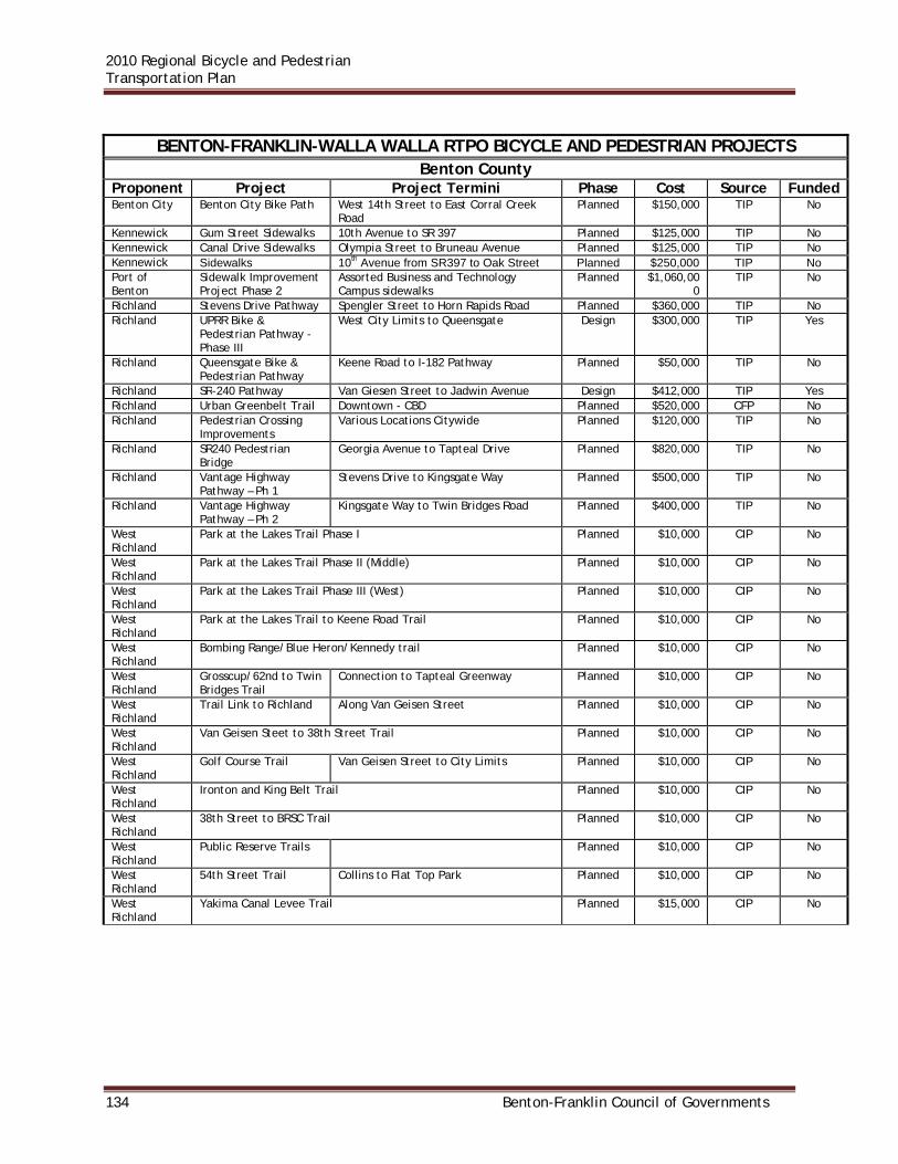
2010 Regional Bicycle and Pedestrian Transportation Plan
134 Benton-Franklin Council of Governments
BENTON-FRANKLIN-WALLA WALLA RTPO BICYCLE AND PEDESTRIAN PROJECTS
Benton County Proponent Project Project Termini Phase Cost Source Funded Benton City Benton City Bike Path West 14th Street to East Corral Creek
Road Planned $150,000 TIP No
Kennewick Gum Street Sidewalks 10th Avenue to SR 397 Planned $125,000 TIP No Kennewick Canal Drive Sidewalks Olympia Street to Bruneau Avenue Planned $125,000 TIP No Kennewick Sidewalks 10th Avenue from SR397 to Oak Street Planned $250,000 TIP No Port of Benton
Sidewalk Improvement Project Phase 2
Assorted Business and Technology Campus sidewalks
Planned $1,060,000
TIP No
Richland Stevens Drive Pathway Spengler Street to Horn Rapids Road Planned $360,000 TIP No Richland UPRR Bike &
Pedestrian Pathway - Phase III
West City Limits to Queensgate Design $300,000 TIP Yes
Richland Queensgate Bike & Pedestrian Pathway
Keene Road to I-182 Pathway Planned $50,000 TIP No
Richland SR-240 Pathway Van Giesen Street to Jadwin Avenue Design $412,000 TIP Yes Richland Urban Greenbelt Trail Downtown - CBD Planned $520,000 CFP No Richland Pedestrian Crossing
Improvements Various Locations Citywide Planned $120,000 TIP No
Richland SR240 Pedestrian Bridge
Georgia Avenue to Tapteal Drive Planned $820,000 TIP No
Richland Vantage Highway Pathway – Ph 1
Stevens Drive to Kingsgate Way Planned $500,000 TIP No
Richland Vantage Highway Pathway – Ph 2
Kingsgate Way to Twin Bridges Road Planned $400,000 TIP No
West Richland
Park at the Lakes Trail Phase I Planned $10,000 CIP No
West Richland
Park at the Lakes Trail Phase II (Middle) Planned $10,000 CIP No
West Richland
Park at the Lakes Trail Phase III (West) Planned $10,000 CIP No
West Richland
Park at the Lakes Trail to Keene Road Trail Planned $10,000 CIP No
West Richland
Bombing Range/Blue Heron/Kennedy trail Planned $10,000 CIP No
West Richland
Grosscup/62nd to Twin Bridges Trail
Connection to Tapteal Greenway Planned $10,000 CIP No
West Richland
Trail Link to Richland Along Van Geisen Street Planned $10,000 CIP No
West Richland
Van Geisen Steet to 38th Street Trail Planned $10,000 CIP No
West Richland
Golf Course Trail Van Geisen Street to City Limits Planned $10,000 CIP No
West Richland
Ironton and King Belt Trail Planned $10,000 CIP No
West Richland
38th Street to BRSC Trail Planned $10,000 CIP No
West Richland
Public Reserve Trails Planned $10,000 CIP No
West Richland
54th Street Trail Collins to Flat Top Park Planned $10,000 CIP No
West Richland
Yakima Canal Levee Trail Planned $15,000 CIP No

2010 Regional Bicycle and Pedestrian Transportation Plan
Benton-Franklin Council of Governments 135
Franklin County Proponent Project Project Termini Phase Cost Source Funded
Connell East Clark Street Sidewalk
Columbia Avenue to Ford Avenue Planned $132,000 TIP No
Connell Date Street Sidewalk South Columbia Avenue to Burke Street Planned $62,000 TIP No Connell Old Railroad ROW
Path Columbia Avenue to Ford Avenue Planned $30,000 TIP No
Connell Ford Avenue Bike Path Extension
Clark Street to North Columbia Avenue Planned $184,000 TIP No
Connell SR 260 Pedestrian Overpass Planned $400,000 TIP No Franklin County
Improve Bike Trail Richland/Pasco Bridge to Harris Road Proposed $62,000 CP No
Franklin County
Improve Road 68 Bike Trail
I-182 to Columbia River Proposed $82,000 CP No
Franklin County
Complete Bike Trail Harris Road to River Bend above Dent Road
Proposed $111,000 CP No
Kahlotus Multi-Use Trail Courtwright Street : Durrum Avenue to Spokane Avenue
Proposed Unknown CP No
Mesa Manton Way Stand-alone Sidewalk
First Avenue to Rowell Avenue Planned $30,000 TIP No
Mesa First Avenue Stand-alone Sidewalk
Columbia Avenue to SR 17 Proposed $52,000 CP No
Mesa Pepiot Road Widen Road & Sidewalk
SR 17 to East School Entrance Proposed $140,000 CP No
Mesa May Avenue Sidewalk Manton Way to Farrell Street Proposed $40,000 CP No Mesa Judson Street
Sidewalk First Avenue to Third Avenue Proposed $30,000 CP No
Mesa Franklin Street Sidewalk
First Avenue to Third Avenue Proposed $60,000 CP No
Mesa Rowell Avenue Sidewalk
Manton Way to Columbia Street Proposed $180,000 CP No
Mesa Columbia Street Sidewalk
First Avenue to Third Avenue Proposed $30,000 CP No
Pasco I-182 Path Widening Road 100 to Broadmoor Boulevard Planned $600,000 - No Pasco Widen Trail along
Columbia River l Road 72 to Road 92 Planned $350,000 - No
Pasco Widen Trail along Columbia River l
Road 54 to Road 72 Planned Unknown - No
Port of Pasco Argent Road Bike and Pedestrian Lane
24th Avenue to Stearman Avenue Planned $150,000 TIP No

2010 Regional Bicycle and Pedestrian Transportation Plan
136 Benton-Franklin Council of Governments
Walla Walla County Proponent Project Project Termini Phase Cost Source Funded College Place Multi-use Trail College Avenue to Ell's 40 Proposed Unknown CP No College Place Multi-use Path Larch Ave to Homestead Village
Subdivision Planned $470,000-
610,000 CIP & TIP Partially
Waitsburg Waitsburg Public School Sidewalk Reconstruction
Weller Street Planned $71,000 TIP No
Waitsburg Pedestrian Trail ¼ mile Planned $11,000 Unknown No Walla Walla Audible Pedestrian
Signals Downtown Three downtown locations Planned $20,000 No
County/City Mill Creek Trail Upgrade
9th to Gose, North Side of Creek Planned Unknown CP No
Walla Walla 13th Street Bike Lanes Rose Street to North of Penitentiary Planned Unknown CP No Walla Walla Around Municipal Golf
Course Trail Lower Waitsburg to Penitentiary Planned Unknown CP No
Walla Walla Northern Link Trail Hwy 12 Trail to Mill Creek Trail Route Study
Unknown CP No
Walla Walla Mill Creek Road Bike Lanes
G Street to Five Mile Road Planned Unknown CP No
County/City Berney, Russell, School, Reser Bike Lanes
Tausick to Cottonwood Planned Unknown CP No
County Cottonwood Trail Eagle Crest to Russel Creek Planned Unknown CP No County Taumarson Trail
(follow old railroad ROW, has sewer line
Justice to Cottonwood (possible rails to trails)
Planned Unknown CP No
Walla Walla Edison Trail Cambridge Drive to Edison Elementary School
Planned Unknown CP No
Walla Walla Rose Street Sidewalk Sidewalk and Pedestrian Crossing to Medical Clinic at 13th
Planned $12,000 CP No
Walla Walla Plazaway Sidewalk East Side, Stone Creek Drive to Tietan Street
Planned Unknown CP No
Walla Walla Mill Creek Bridge to Sports Park
Mill Creek Trail to Mill Creek Sports Complex (Parks request)
Planned $200,000 CP No
Walla Walla Chestnut Sidewalk 9th to Blue Ridge School (Safe Route to Schools Grant)
Planned $70,000 CP No
Walla Walla Mill Creek Bike Path Repave
East Lions Park to Tausick Way Planned Unknown CP No
Walla Walla Isaacs Avenue Bike Lanes
Wilbur Avenue to Airport Road Planned Unknown CP No
Walla Walla Heritage Park Pedestrian Bridge
Over Mill Creek Planned $100,000 CP No
Walla Walla Tietan Street Pedestrian Improvements
Plaza Way to 4th Avenue Planned $400,000 CP No
County Cottonwood Bike Lanes Eagle Crest to Kendall Road Planned Unknown CP No Walla Walla Park Street bike and
pedestrian improvements
Whitman College to Sharpstien School (Safe Route to Schools Grant)
Study 25,000 CP No
FUNDING

2010 Regional Bicycle and Pedestrian Transportation Plan
Benton-Franklin Council of Governments 137
FUNDING SOURCES There is a wide range of potential funding sources for improving pedestrian and bicycle transportation options. FEDERAL The Intermodal Surface Transportation Efficiency Act of 1991 included several funding categories wherein improvements for pedestrian and bicycle transportation could be funded, either as part of a road improvement project or an independent improvement. The 1998 TEA 21 legislation perpetuated those funding categories. Of particular significance is the ten percent set aside of surface transportation funds for enhancements, which contains a specific category for pedestrian and bicycle facilities. 2005 marked the passage of the Safe, Accountable, Flexible, Efficient Transportation Act – A Legacy For Users (SAFETEA-LU), which reauthorizes the federal highway and transit programs through FY 2009. The bill increased funding of the Surface Transportation Program (STP) by roughly 30 percent. Tansportation Enhancements continue to be funded through a 10 percent set-aside of STP funds or the amount set aside in 2005, whichever is greater. As of 2009, over $5.3 million in enhancement funds have been allocated to projects in the RTPO area since the inception of the program, with $3.0 million, or 57 percent, awarded to bicycle/pedestrian facilities. STATE Pedestrian and Bicycle Safety Funding In 2005, the Governor and Washington State Legislature increased the state’s role in safety by providing funding that supports pedestrian and bicycle safety and safe routes to school projects (ESSB 6091). In addition, with the passage of SAFETEA-LU in 2005, a new federal Safe Routes to School program was established that provided federal funding to the state. Pedestrian and Bicycle Safety Grant This program focuses on pedestrian and bicycle safety and providing children a safe, healthy alternative to riding the bus or being driven to school. Its purpose is to aid public agencies in funding cost-effective projects that improve pedestrian and bicycle safety through engineering, education and enforcement. Safe Routes to School The purpose of this program is to aid public agencies in funding cost-effective projects within two-miles of primary and middle schools (K-8) that provide children a safe, healthy alternative to riding the bus or being driven to school.

2010 Regional Bicycle and Pedestrian Transportation Plan
138 Benton-Franklin Council of Governments
These two programs are very lightly funded and highly desired. Grant cycles are based on the budget biennium, so there have been three full funding periods to date: 2005-2007, 2007-2009 and 2009-2011. The Pedestrian and Bicycle Safety program, over the combined 2005-2007 and 2007-2009 periods, had $15 million available which funded 47 projects from the over $63 million in requests. In the RTPO, a single project in Kennewick was funded during these two cycles. Safe Routes to Schools had a total of $10 million available to fund 39 projects from the over $49 million requested. In the RTPO, two projects were funded in Walla Walla during these two cycles. For the 2009-2011 biennium, approximately $11 million was available to fund the over $82 million in requests received. WSDOT received 92 Pedestrian and Bicycle Safety project applications totaling approximately $35 million. Statewide, 16 projects were funded. Four were submitted from within the RTPO and one, from Richland was funded. The State received 112 Safe Routes to Schools project applications and funded 21. Three were submitted from the RTPO and none were funded. Additional Funding Sources Under RCW 47.30, Paths and Trails, 0.3 percent of state construction expenditures must be spent on paths and trails: WSDOT estimates that it spends about 0.5 percent. This amounted to about $2.4 million in 1994. Some of these monies are distributed to cities and counties. The Transportation Improvement Board (TIB) has assorted legislatively funded categories wherein cities and counties annually compete for project funds. Some of these categories are specifically earmarked for pedestrian or bicycle improvements. Other categories for roadway and street improvement projects require pedestrian elements on either one or both sides. Community Development Block Grants target communities and neighborhoods that are principally low and moderate income. Such communities tend to have high demand for pedestrian and bicycle travel and public transit services. Funding is for street improvement projects, presumably including non-motorized and transit elements. LOCAL Municipalities have an array of funding sources available to them. Consideration should be given to prioritizing those sources that are collected from motor vehicle travel and from development that contributes to sprawl. These sources will help recover some of the costs not currently included in the price of these activities. Local revenue sources include: the road portion of “impact fees,” county-wide vehicle license fees, commercial parking tax, local street utility tax, county-wide fuel tax, property tax, Local Improvement Districts, real estate excise tax, Transportation Benefit Districts, toll roads, and bonds.

2010 Regional Bicycle and Pedestrian Transportation Plan
Benton-Franklin Council of Governments 139
FUNDING AND IMPLEMENTATION PRACTICES Bike lanes, shoulder bikeways, and sidewalks, which make up the majority of the bicycle and pedestrian system, are usually implemented as part of a standard roadway project and represent a small fraction of a project’s cost. As new arterials and collectors are constructed or old ones are reconstructed to current standards, appropriate bikeways and walkways should be included in the project. Walkways and bikeways may also be provided as a part of routine roadway repairs. Resurfacing of an arterial or collector is an excellent time to restripe for bike lanes at little additional cost. In this way a bikeway system can develop incrementally in step with the road system. For construction projects it is important to coordinate with other roadwork so as to keep expenses – administration, material unit costs, mobilization, traffic control – to a minimum by sharing them with larger road projects. For example, shoulder widening to accommodate pedestrians and bicycles in a rural area might be prohibitively expensive unless done at the same time as a scheduled pavement overlay; this can reduce shoulder costs by as much as half. Walkway and bikeway maintenance should be funded along with routine roadway maintenance. Special projects such as separated paths, shoulders added to a road that is in good condition, and restriping existing roads for bike lanes require dedicated funding. In private developments, pedestrian and bicycle facilities are made a condition of approval, just as are the roads and parking lots. In some cases, System Development Charges (SDCs) or transportation impact fees can be imposed. If the impact of a development on adjacent streets is not immediate, the developer may participate in future improvements through a Local Improvement District (LID). It is to a jurisdiction’s advantage to develop a consistent funding source for priority projects and maintenance, and to actively seek additional sources for the remaining projects. Available money should be leveraged to the greatest extent possible by using it for matching grants and joint projects. Coordination of construction projects and maintenance between various agencies and private development helps reduce costs, not just for bikeways and walkways, but also for the entire urban infrastructure. For example, state and local public works departments should strive to form partnerships that allow efficient sharing of resources (materials, equipment, and labor) and quick response to opportunities. Bicycle facilities and programs are a community investment shared by all sectors – private, business, and government. Each can contribute in many ways, including land dedications, donations of engineering and public relations talent, special grants, sponsorship of fund-raising events, and so on. Developers can also choose to include extra bikeway projects, beyond what is required, in their project designs. Businesses can voluntarily construct showers and offer incentives for their employees. These sources should be actively sought and nurtured.

2010 Regional Bicycle and Pedestrian Transportation Plan
140 Benton-Franklin Council of Governments
Students could be utilized to provide low-cost sidewalk repairs or bike path maintenance in exchange for on-the-job training. Other inventive means for obtaining materials, funds, or rights of way include environmental impact mitigation, street vacation money, enforcement of franchise agreements for railroad crossings, utility tax for public works, utility easements, and tax-deductible gifts in the form of signs, equipment, and trail segments.

2010 Regional Bicycle and Pedestrian Transportation Plan
Benton-Franklin Council of Governments 141
APPENDICES

2010 Regional Bicycle and Pedestrian Transportation Plan
142 Benton-Franklin Council of Governments
APPENDIX A-DEFINITIONS Activity Centers: Locations such as schools, parks, shopping, employment, or public service agencies that attract people. American Association of State Highway and Transportation Officials (AASHTO): A group that developed the Guide for Development of Bicycle Facilities, August 1991, which is the accepted standard for safe bicycle design standards. Americans with Disabilities Act of 1990 (ADA): A Federal law prohibiting discrimination against people with disabilities. Requires public entities and public facilities to provide accessible accommodations for people with disabilities. Bicycle Facilities: A general term referring to improvements that accommodate or encourage bicycling, including parking facilities, bike racks, bicycle route mapping, and bicycle route development. Bicycle Route (Bike Route): Any route (Class I, II, III, or IV) specified for bicycle travel, whether exclusive for bicyclists or to be shared with other transportation modes.
Class I – Bicycle Path: A portion of a public or private roadway, dedicated to the use of bicyclists and pedestrians, and separated from motorized vehicular traffic by open space, landscaped area, or barrier.
Class II – Bicycle Lane: A portion of a public roadway designated by striping and pavement markings for the preferential or exclusive use of bicyclists.
Class III – Shared Roadway: Key links in the bicycle system, generally signed but unmarked. These streets will usually have wider curb lanes (14-foot minimum) and should be safe for bicycle access. These links are identified on the bicycle system maps and bicycle project lists that will provide more details on street design and specifications.
Class IV – Other Bicycle Streets: Any roadway without signs or a designated bicycle lane but which bicyclists may legally use.
Bollard: A post-like device that restricts some types of access (usually motorized) while allowing other types of access (usually pedestrian and/or bike).
Removable Bollard: A bollard, which may be removed, usually including a locking device, and is most often removed for access by a maintenance vehicle.
Bus Stop: A place where buses stop to load or unload passengers. Central Business District (CBD): The primary business area of a city, usually in the downtown core area. Comprehensive Plan: A document that includes policies and the vision for the future growth and development of a city or county for all functional areas.

2010 Regional Bicycle and Pedestrian Transportation Plan
Benton-Franklin Council of Governments 143
Curb Lane: The lane adjacent to the curb, commonly called the outside lane. Curb Ramp: A ramp cut into a roadway curb to allow access for physically challenged pedestrians to and from sidewalks and roadways. Dedicated Tracts: Private land set aside for utility use and access, vegetation protection, storm water retention, or other purposes. Development Standards/(Design Standards): A document that contains many of the city, county, or state standards to guide the development and project design process. Easements:
Non-motorized Public Easement: An easement recorded on a property for walking, bicycling or equestrian public use.
Utility Easement: An easement recorded on a property for the sole access of a utility company to maintain or construct utilities such as sewer, water, telephone, storm drainage, and electrical and cable lines.
Finding: A factual statement resulting from investigation, analysis, or observation. Funding Programs: Funding programs that are available to finance certain types of improvement projects depending on the source of funding, the project’s size, and type of project. These programs may include:
Capital Improvement Program (CIP): A six-year list of funded projects adopted by a city council. This list of projects is updated every one to two years. Councils hold public hearings to solicit ideas of the citizens prior to adopting the new lists. The CIPs generally cover all city departments and public facilities. Neighborhood Enhancement Program (NEP): A program whereby funds may be allocated to different areas of a city, and citizens identify needs and decide amongst themselves which projects will be funded.
Street Rehabilitation Fund (Overlay): A fund in a Capital Improvement Program for providing major street maintenance and street overlays for extending the life of the street system. Minor Capital Projects Fund: A part of a Street Overlay Fund for constructing minor capital improvements throughout a city. Walkway/Bikeway Fund: A subcategory that could be included in a Minor Capital Projects Fund for constructing walkway or bikeway projects.
Geographic Information System (GIS): A computer based mapping and data system that is geographically based (tied to coordinates). High Occupancy Vehicle (HOV): An automobile, vanpool, or bus with more than one occupant.

2010 Regional Bicycle and Pedestrian Transportation Plan
144 Benton-Franklin Council of Governments
Intermodal Surface Transportation Efficiency Act of 1991 (ISTEA): Federal legislation authorizing highway, highway safety, transit, and other surface transportation programs for 1991 through 1997. It provided new funding opportunities for sidewalks, shared-use paths, and recreational trails. ISTEA was superseded by the Transportation Equity Act for the 21st Century. Intermodalism: The use of multiple types of transportation to reach one destination; includes combining the use of trains and buses, automobiles, bicycles, and pedestrian transport on a given trip. Landscaping Strip: A planted strip (desirable four foot minimum width), with or without street trees, constructed along the street frontage between the back of curb and the sidewalk in a public easement or right of way. Limited-Purpose Path: A type of trail that is primarily a recreation facility, designed with a narrow width (two to six feet) and surfaced with chips, gravel, or dirt. Its design may include stairs and other obstacles that restrict certain types of usage. Local Improvement District (LID): Funds for capital projects that are derived from owners of properties adjacent to or near the project. Owners agree to pay a share of the project’s cost through an assessment against their properties. Long-range transportation plan: A transportation plan developed by States and MPOs to encapsulate 20 years of transportation planning and policy. Markings: Designs for pavement markings are based on the federal Manual on Uniform Traffic Control Devices (MUTCD).
Stencils: Legends placed on roadways, shoulders, or walkways in paint or thermoplastic, which establish the intended roadway use.
Reflectors: Raised or inset pavement markings that become illuminated when struck by vehicle headlights.
Buttons: Raised pavement markings used to delineate roadway channelization.
Rumble Strips: Raised or inset pavement markings used most commonly to separate roadways from roadway shoulders. Crosswalks: Pavement markings and signing designating where pedestrians may cross into vehicular roadways. Pedestrian-Activated Signals: Traffic signals equipped with separate pedestrian phases that can be activated by a pedestrian at an intersection.
Bicycle-Activated Signals: Traffic signals that can be activated by a bicycle at an intersection.

2010 Regional Bicycle and Pedestrian Transportation Plan
Benton-Franklin Council of Governments 145
Paint Stripe/Edge Line: A fogline, usually a four or eight inch painted white line that is commonly used to separate a roadway from a roadway shoulder.
Meandering Sidewalk: A sidewalk with horizontal alignment shifts back and forth from the curb in response to factors such as site conditions or design. Used to preserve large trees or because of topography. Metropolitan Planning Organization (MPO): A regional transportation planning and policy agency for urban areas with populations larger than 50,000. Metropolitan Transportation Plan (MTP): A 20-year transportation plan for a federally designated Metropolitan or Urban Area (e.g. the Tri-Cities). Mid-Block Connection: A pedestrian path designed to provide more direct pedestrian access through a superblock area. Mid-Block Pedestrian Crossing: A signed or marked pedestrian crossing at a location other than a roadway intersection. Minimum Energy Path: The route between two given points requiring the least amount of energy for a bicyclist or pedestrian to traverse. Multi-Purpose Path: A type of trail designed with a medium width (six to ten feet) and surfaced with compacted gravel or asphalt. Non-Motorized: Transportation modes that do not require motors, commonly including pedestrian travel, bicycle travel, equestrian, jogging, skateboarding, and rollerblading. Paved Path: A type of path that is primarily a transportation facility, designed with medium width (six to ten feet), surfaced with concrete or asphalt, and separated from roadway either vertically or horizontally. Paths can be built alongside streets or on independent off-street alignments and are designed to accommodate all users, except when grades prohibit. Pedestrian: A person who walks. For this plan this category includes wheelchairs, horses, and other non-motorized uses, except bicycles. Pedestrian Connection: A continuous, readily accessible, usable area, open at either end and designed primarily to provide public access between two or more publicly accessible spaces, including public sidewalks, by means of a direct route. Pedestrian Oriented Frontage: Building frontage devoted to uses that stimulate pedestrian activity at the pedestrian level. Uses are typically sidewalk-oriented and are physically or visually accessible to pedestrians from the sidewalks. Regional Transportation Plan (RTP): A 20-year transportation plan for a state designated Regional Transportation Planning Organization (area). In our case, the 3-county RTPO consisting of Benton, Franklin, and Walla Walla Counties.
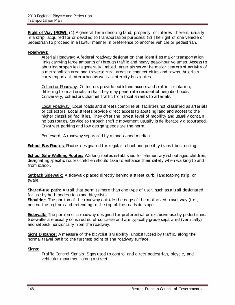
2010 Regional Bicycle and Pedestrian Transportation Plan
146 Benton-Franklin Council of Governments
Right of Way (ROW): (1) A general term denoting land, property, or interest therein, usually in a strip, acquired for or devoted to transportation purposes; (2) The right of one vehicle or pedestrian to proceed in a lawful manner in preference to another vehicle or pedestrian. Roadways:
Arterial Roadway: A federal roadway designation that identifies major transportation links carrying large amounts of through traffic and heavy peak-hour volumes. Access to abutting properties is generally limited. Arterials serve the major centers of activity of a metropolitan area and traverse rural areas to connect cities and towns. Arterials carry important interurban as well as intercity bus routes.
Collector Roadway: Collectors provide both land access and traffic circulation, differing from arterials in that they may penetrate residential neighborhoods. Conversely, collectors channel traffic from local streets to arterials.
Local Roadway: Local roads and streets comprise all facilities not classified as arterials or collectors. Local streets provide direct access to abutting land and access to the higher classified facilities. They offer the lowest level of mobility and usually contain no bus routes. Service to through traffic movement usually is deliberately discouraged. On-street parking and low design speeds are the norm.
Boulevard: A roadway separated by a landscaped median.
School Bus Routes: Routes designated for regular school and possibly transit bus routing. School Safe-Walking Routes: Walking routes established for elementary school aged children, designating specific routes children should take to enhance their safety when walking to and from school. Setback Sidewalk: A sidewalk placed directly behind a street curb, landscaping strip, or swale. Shared-use path: A trail that permits more than one type of user, such as a trail designated for use by both pedestrians and bicyclists. Shoulder: The portion of the roadway outside the edge of the motorized travel way (i.e., behind the fogline) and extending to the top of the roadside slope. Sidewalk: The portion of a roadway designed for preferential or exclusive use by pedestrians. Sidewalks are usually constructed of concrete and are typically grade separated (vertically) and setback horizontally from the roadway. Sight Distance: A measure of the bicyclist’s visibility, unobstructed by traffic, along the normal travel path to the furthest point of the roadway surface. Signs:
Traffic Control Signals: Signs used to control and direct pedestrian, bicycle, and vehicular movement along a street.

2010 Regional Bicycle and Pedestrian Transportation Plan
Benton-Franklin Council of Governments 147
Directional Signs: Signs used to direct pedestrians, bicycles, and vehicles to the appropriate route or destination. These signs are commonly located at street intersections and other decision points.
Information Signs: Signs used to identify a number of different area amenities including parking areas, delivery areas, etc.
Trail Signs: Signs used to identify trail routes and lengths.
Single Occupant Vehicle (SOV): An automobile with one person (driver). Social Trail: An informal pedestrian pathway established over time by continued pedestrian/bicycle use. May or may not be located on public right of way or easement. Special Needs Population: Persons with conditions or needs that may require unique consideration in designing or operating the transportation system. Special needs may include physical, mental, emotional, or language needs. State Environmental Policy Act (SEPA): The Washington State environmental legislation that supplements the federal environmental act (NEPA). Street Furniture: Supplemental pedestrian-oriented amenities such as benches, drinking fountains, and garbage receptacles, typically located in the right of way or on an easement adjacent to the right of way, for the intended use of persons using pedestrian or bicycle facilities. Street Trees (Public): Trees located in the right of way or on easements adjacent to a roadway. Trees located in the public right of way between the curb and sidewalk in a landscaping strip, behind a sidewalk along the adjacent property line, or in medians of streets. Surface Transportation Program (STP): A Federal program that provides grants to States for federally funded roadways and enhancement projects. Superblock: A large block of urban development surrounded by arterial streets and lacking motorized (and many times non-motorized) internal through connections. Trail: A non-motorized transportation route. Transit Routes: Streets designated for transit routing. Transportation Demand Management (TDM): A strategy directed at reducing peak period trip making through programs that support alternate modes, high occupancy vehicle, or transit use, and discourage single occupancy vehicles. Transportation Enhancement: Projects that include providing bicycle and pedestrian facilities; converting abandoned railroad rights-of-way into trails; preserving historic transportation sites; acquiring scenic easements; mitigating the negative impacts of a project on a community by providing additional benefits; and other projects.

2010 Regional Bicycle and Pedestrian Transportation Plan
148 Benton-Franklin Council of Governments
Transportation Equity Act for the 21st Century (TEA-21): Federal legislation authorizing highway, highway safety, transit, and other surface transportation programs from 1998 through 2003. It provided funding opportunities for pedestrian, bicycling, and public transit facilities and emphasized intermodalism, multimodalism, and community participation in transportation planning initiated by ISTEA. Transportation Improvement Program or Statewide Transportation Improvement Plan (TIP or STIP): A transportation plan that encapsulates planning and policy for a minimum of 3 years. The document includes a prioritized list of all projects that will be constructed with Federal transportation funding. Urban: Refers to places within boundaries set by State and local officials that have a population of 50,000 or more. Urban areas are more densely populated and contain a higher density of built structures. Walkway: A paved or improved surface designated for use primarily by pedestrians, and is next to a street, generally separated by a ditch, gravel, or landscaping. It is within the right of way or an easement and is usually grade separated from the vehicular roadway. Walkway, Internal: A walkway located within the block. Walkway or Sidewalk, Perimeter: A walkway that functions as the public sidewalk fronting on a public street.

2010 Regional Bicycle and Pedestrian Transportation Plan
Benton-Franklin Council of Governments 149
APPENDIX B – BICYCLE AND PEDESTRIAN COLLISION DATA STATE HIGHWAYS
2001-2008 BICYCLE AND PEDESTRIAN COLLISION DATA
State Highways in the RTPO
Year Collisions Bicycle Collisions Pedestrian Collisions Urban Rural
Injuries Fatalities Injuries Fatalities Injuries Fatalities Injuries Fatalities
2001 5 2 0 1 1 2 1 1 0
2002 13 8 0 6 0 12 0 2 0
2003 8 4 0 3 1 4 0 3 1
2004 8 6 1 2 0 7 0 1 1
2005 3 2 0 1 0 2 0 1 0
2006 7 5 0 2 0 6 0 1 0
2007 10 3 0 2 1 3 0 2 1
2008 10 6 0 4 0 8 0 2 0
Total 64 36 1 21 3 44 1 13 3
BENTON COUNTY
2001-2008 BICYCLE AND PEDESTRIAN COLLISION DATA
County Roads - Benton County
Year Collisions Bicycle Collisions Pedestrian Collisions
Injuries Fatalities Injuries Fatalities
2001 3 0 0 2 1
2002 0 0 0 0 0
2003 2 0 0 0 2
2004 2 2 0 0 0
2005 1 0 0 1 0
2006 3 4 0 0 0
2007 2 2 0 0 0
2008 3 1 0 2 0
Total 16 9 0 5 3

2010 Regional Bicycle and Pedestrian Transportation Plan
150 Benton-Franklin Council of Governments
BENTON COUNTY JURISDICTIONS
BICYCLE AND PEDESTRIAN COLLISION DATA
Benton County Jurisdictions - 2001
Jurisdiction Collisions Bicycle Collisions Pedestrian Collisions
Injuries Fatalities Injuries Fatalities
Benton City 1 0 0 1 0
Kennewick 27 11 0 15 0
Prosser 1 1 0 0 0
Richland 17 8 0 9 0
West Richland 3 2 0 1 0
Total 49 22 0 26 0
BICYCLE AND PEDESTRIAN COLLISION DATA
Benton County Jurisdictions - 2002
Jurisdiction Collisions Bicycle Collisions Pedestrian Collisions
Injuries Fatalities Injuries Fatalities
Benton City 2 1 0 1 0
Kennewick 17 5 0 12 0
Prosser 2 1 0 1 0
Richland 21 12 0 8 0
West Richland 1 0 0 0 0
Total 43 19 0 22 0
BICYCLE AND PEDESTRIAN COLLISION DATA
Benton County Jurisdictions - 2003
Jurisdiction Collisions Bicycle Collisions Pedestrian Collisions
Injuries Fatalities Injuries Fatalities
Benton City 0 0 0 0 0
Kennewick 30 12 1 15 0
Prosser 4 6 0 0 0
Richland 20 7 0 12 0
West Richland 1 0 0 1 0
Total 55 25 1 28 0

2010 Regional Bicycle and Pedestrian Transportation Plan
Benton-Franklin Council of Governments 151
BICYCLE AND PEDESTRIAN COLLISION DATA
Benton County Jurisdictions - 2004
Jurisdiction Collisions Bicycle Collisions Pedestrian Collisions
Injuries Fatalities Injuries Fatalities
Benton City 0 0 0 0 0
Kennewick 34 15 0 17 0
Prosser 1 0 0 1 0
Richland 18 14 0 5 0
West Richland 1 0 0 0 0
Total 54 31 0 24 0
BICYCLE AND PEDESTRIAN COLLISION DATA
Benton County Jurisdictions - 2005
Jurisdiction Collisions Bicycle Collisions Pedestrian Collisions
Injuries Fatalities Injuries Fatalities
Benton City 0 0 0 0 0
Kennewick 26 11 0 14 0
Prosser 1 0 0 1 0
Richland 16 7 0 9 0
West Richland 0 0 0 0 0
Total 43 18 0 25 0
BICYCLE AND PEDESTRIAN COLLISION DATA
Benton County Jurisdictions - 2006
Jurisdiction Collisions Bicycle Collisions Pedestrian Collisions
Injuries Fatalities Injuries Fatalities
Benton City 0 0 0 0 0
Kennewick 21 9 0 10 1
Prosser 2 1 0 1 0
Richland 17 5 0 10 1
West Richland 0 0 0 0 0
Total 40 18 0 21 2

2010 Regional Bicycle and Pedestrian Transportation Plan
152 Benton-Franklin Council of Governments
BICYCLE AND PEDESTRIAN COLLISION DATA
Benton County Jurisdictions - 2007
Jurisdiction Collisions Bicycle Collisions Pedestrian Collisions
Injuries Fatalities Injuries Fatalities
Benton City 0 0 0 0 0
Kennewick 20 12 0 8 0
Prosser 1 1 0 0 0
Richland 14 8 0 7 0
West Richland 0 0 0 0 0
Total 35 23 0 15 0
BICYCLE AND PEDESTRIAN COLLISION DATA
Benton County Jurisdictions - 2008
Jurisdiction Collisions Bicycle Collisions Pedestrian Collisions
Injuries Fatalities Injuries Fatalities
Benton City 0 0 0 1 0
Kennewick 21 11 0 8 0
Prosser 2 2 0 1 0
Richland 11 4 0 7 0
West Richland 0 0 0 0 0
Total 34 19 0 17 0
BENTON COUNTY COLLISIONS BY ROAD CLASSIFICATION
BENTON COUNTY
2001 BICYCLE AND PEDESTRIAN COLLISIONS
Collisions Injuries Fatalities Bike
Collisions Pedestrian Collisions
State Routes 2 1 1 1 1
County Roads 3 2 1 0 3
City Streets 49 48 0 22 26
TOTALS 54 51 2 23 30

2010 Regional Bicycle and Pedestrian Transportation Plan
Benton-Franklin Council of Governments 153
BENTON COUNTY
2002 BICYCLE AND PEDESTRIAN COLLISIONS
Collisions Injuries Fatalities Bike
Collisions Pedestrian Collisions
State Routes 10 11 0 6 4
County Roads 0 0 0 0 0
City Streets 43 41 0 19 22
TOTALS 53 52 0 25 26
BENTON COUNTY
2003 BICYCLE AND PEDESTRIAN COLLISIONS
Collisions Injuries Fatalities Bike
Collisions Pedestrian Collisions
State Routes 3 4 0 3 0
County Roads 2 0 2 0 2
City Streets 55 53 1 25 28
TOTALS 60 57 3 28 30
BENTON COUNTY
2004 BICYCLE AND PEDESTRIAN COLLISIONS
Collisions Injuries Fatalities Bike
Collisions Pedestrian Collisions
State Routes 5 6 0 3 2
County Roads 2 2 0 2 0
City Streets 53 49 0 30 23
TOTALS 60 57 0 35 25
BENTON COUNTY
2005 BICYCLE AND PEDESTRIAN COLLISIONS
Collisions Injuries Fatalities Bike
Collisions Pedestrian Collisions
State Routes 1 1 0 0 1
County Roads 1 1 0 0 1
City Streets 43 42 0 19 24
TOTALS 45 44 0 19 26

2010 Regional Bicycle and Pedestrian Transportation Plan
154 Benton-Franklin Council of Governments
BENTON COUNTY
2006 BICYCLE AND PEDESTRIAN COLLISIONS
Collisions Injuries Fatalities Bike
Collisions Pedestrian Collisions
State Routes 4 4 0 4 0
County Roads 3 4 0 3 0
City Streets 40 36 2 18 22
TOTALS 47 44 2 25 22
BENTON COUNTY
2007 BICYCLE AND PEDESTRIAN COLLISIONS
Collisions Injuries Fatalities Bike
Collisions Pedestrian Collisions
State Routes 4 3 0 2 2
County Roads 2 2 0 2 0
City Streets 35 35 0 21 14
TOTALS 41 40 0 25 16
BENTON COUNTY
2008 BICYCLE AND PEDESTRIAN COLLISIONS
Collisions Injuries Fatalities Bike
Collisions Pedestrian Collisions
State Routes 7 7 0 4 3
County Roads 3 3 0 1 2
City Streets 36 34 0 19 17
TOTALS 46 44 0 24 22

2010 Regional Bicycle and Pedestrian Transportation Plan
Benton-Franklin Council of Governments 155
FRANKLIN COUNTY
2001-2008 BICYCLE AND PEDESTRIAN COLLISION DATA
County Roads - Franklin County
Year Collisions Bicycle Collisions Pedestrian Collisions
Injuries Fatalities Injuries Fatalities
2001 0 0 0 0 0
2002 1 0 0 1 0
2003 0 0 0 0 0
2004 1 1 0 0 0
2005 0 0 0 0 0
2006 0 0 0 0 0
2007 1 1 0 0 0
2008 0 0 0 0 0
Total 3 2 0 1 0
FRANKLIN COUNTY JURISDICTIONS
BICYCLE AND PEDESTRIAN COLLISION DATA
Franklin County Jurisdictions - 2001
Jurisdiction Collisions Bicycle Collisions Pedestrian Collisions
Injuries Fatalities Injuries Fatalities
Connell 0 0 0 0 0
Pasco 18 7 0 10 0
Total 18 7 0 10 0
BICYCLE AND PEDESTRIAN COLLISION DATA
Franklin County Jurisdictions - 2002
Jurisdiction Collisions Bicycle Collisions Pedestrian Collisions
Injuries Fatalities Injuries Fatalities
Connell 1 1 0 0 0
Pasco 15 7 0 6 1
Total 16 8 0 6 1

2010 Regional Bicycle and Pedestrian Transportation Plan
156 Benton-Franklin Council of Governments
BICYCLE AND PEDESTRIAN COLLISION DATA
Franklin County Jurisdictions - 2003
Jurisdiction Collisions Bicycle Collisions Pedestrian Collisions
Injuries Fatalities Injuries Fatalities
Connell 2 0 0 1 0
Pasco 6 1 0 4 0
Total 8 1 0 5 0
BICYCLE AND PEDESTRIAN COLLISION DATA
Franklin County Jurisdictions - 2004
Jurisdiction Collisions Bicycle Collisions Pedestrian Collisions
Injuries Fatalities Injuries Fatalities
Connell 0 0 0 0 0
Pasco 10 6 0 3 0
Total 10 6 0 3 0
BICYCLE AND PEDESTRIAN COLLISION DATA
Franklin County Jurisdictions - 2005
Jurisdiction Collisions Bicycle Collisions Pedestrian Collisions
Injuries Fatalities Injuries Fatalities
Connell 0 0 0 0 0
Pasco 12 7 0 6 0
Total 12 7 0 6 0
BICYCLE AND PEDESTRIAN COLLISION DATA
Franklin County Jurisdictions - 2006
Jurisdiction Collisions Bicycle Collisions Pedestrian Collisions
Injuries Fatalities Injuries Fatalities
Connell 0 0 0 0 0
Pasco 14 7 0 8 0
Total 14 7 0 8 0
BICYCLE AND PEDESTRIAN COLLISION DATA

2010 Regional Bicycle and Pedestrian Transportation Plan
Benton-Franklin Council of Governments 157
Franklin County Jurisdictions - 2007
Jurisdiction Collisions Bicycle Collisions Pedestrian Collisions
Injuries Fatalities Injuries Fatalities
Connell 0 0 0 0 0
Pasco 13 4 0 7 2
Total 13 4 0 7 2
BICYCLE AND PEDESTRIAN COLLISION DATA
Franklin County Jurisdictions - 2008
Jurisdiction Collisions Bicycle Collisions Pedestrian Collisions
Injuries Fatalities Injuries Fatalities
Connell 1 0 0 2 0
Pasco 11 4 0 7 0
Total 12 4 0 9 0
FRANKLIN COUNTY BY ROAD CLASSIFICATION
FRANKLIN COUNTY
2001 BICYCLE AND PEDESTRIAN COLLISIONS
Collisions Injuries Fatalities Bike
Collisions Pedestrian Collisions
State Routes 0 0 0 0 0
County Roads 0 0 0 0 0
City Streets 18 17 0 7 10
TOTALS 18 17 0 7 10

2010 Regional Bicycle and Pedestrian Transportation Plan
158 Benton-Franklin Council of Governments
FRANKLIN COUNTY
2002 BICYCLE AND PEDESTRIAN COLLISIONS
Collisions Injuries Fatalities Bike
Collisions Pedestrian Collisions
State Routes 1 1 0 0 1 County Roads 1 1 0 0 1 City Streets 16 14 1 8 8
TOTALS 18 16 1 8 10
FRANKLIN COUNTY
2003 BICYCLE AND PEDESTRIAN COLLISIONS
Collisions Injuries Fatalities Bike
Collisions Pedestrian Collisions
State Routes 0 0 0 0 0 County Roads 0 0 0 0 0 City Streets 8 6 0 2 6
TOTALS 8 6 0 2 6
FRANKLIN COUNTY
2004 BICYCLE AND PEDESTRIAN COLLISIONS
Collisions Injuries Fatalities Bike
Collisions Pedestrian Collisions
State Routes 1 1 0 1 0 County Roads 1 1 0 1 0 City Streets 10 9 0 7 3
TOTALS 12 11 0 9 3

2010 Regional Bicycle and Pedestrian Transportation Plan
Benton-Franklin Council of Governments 159
FRANKLIN COUNTY
2005 BICYCLE AND PEDESTRIAN COLLISIONS
Collisions Injuries Fatalities Bike
Collisions Pedestrian Collisions
State Routes 1 1 0 1 0 County Roads 0 0 0 0 0 City Streets 12 13 0 7 5
TOTALS 13 14 0 8 5
FRANKLIN COUNTY
2006 BICYCLE AND PEDESTRIAN COLLISIONS
Collisions Injuries Fatalities Bike
Collisions Pedestrian Collisions
State Routes 0 0 0 0 1 County Roads 0 0 0 0 0 City Streets 14 15 0 7 7
TOTALS 14 15 0 7 8
FRANKLIN COUNTY
2007 BICYCLE AND PEDESTRIAN COLLISIONS
Collisions Injuries Fatalities Bike
Collisions Pedestrian Collisions
State Routes 3 1 1 1 2 County Roads 1 1 0 1 0 City Streets 13 11 2 4 9
TOTALS 17 13 3 6 11

2010 Regional Bicycle and Pedestrian Transportation Plan
160 Benton-Franklin Council of Governments
FRANKLIN COUNTY
2008 BICYCLE AND PEDESTRIAN COLLISIONS
Collisions Injuries Fatalities Bike
Collisions Pedestrian Collisions
State Routes 0 0 0 0 0
County Roads 0 0 0 0 0
City Streets 12 13 0 4 8
TOTALS 12 13 0 4 8

2010 Regional Bicycle and Pedestrian Transportation Plan
Benton-Franklin Council of Governments 161
WALLA WALLA COUNTY
2001-2008 BICYCLE AND PEDESTRIAN COLLISION DATA County Roads - Walla Walla County
Year Collisions Bicycle Collisions Pedestrian Collisions Injuries Fatalities Injuries Fatalities 2001 0 0 0 0 0 2002 1 1 0 0 0 2003 0 0 0 0 0 2004 1 1 0 0 0 2005 2 0 0 2 0 2006 1 1 0 0 0 2007 3 1 0 2 0 2008 2 1 0 1 0 Total 10 5 0 5 0
WALLA WALLA COUNTY JURISDICTIONS
BICYCLE AND PEDESTRIAN COLLISION DATA
Walla Walla County Jurisdictions - 2001
Jurisdiction Collisions Bicycle Collisions Pedestrian Collisions
Injuries Fatalities Injuries Fatalities
College Place 1 0 0 1 0
Walla Walla 11 7 0 4 0
Total 12 7 0 5 0
BICYCLE AND PEDESTRIAN COLLISION DATA
Walla Walla County Jurisdictions - 2002
Jurisdiction Collisions Bicycle Collisions Pedestrian Collisions
Injuries Fatalities Injuries Fatalities
College Place 1 0 0 2 0
Walla Walla 24 14 0 9 0
Total 25 14 0 11 0
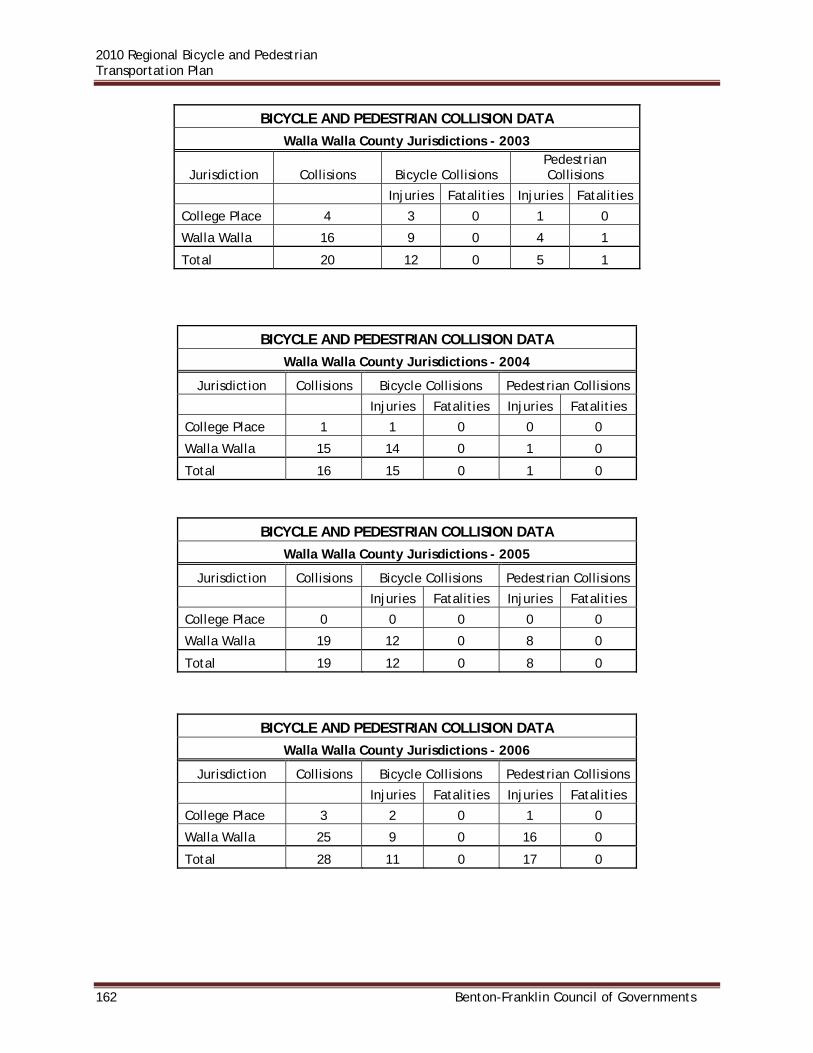
2010 Regional Bicycle and Pedestrian Transportation Plan
162 Benton-Franklin Council of Governments
BICYCLE AND PEDESTRIAN COLLISION DATA
Walla Walla County Jurisdictions - 2003
Jurisdiction Collisions Bicycle Collisions Pedestrian Collisions
Injuries Fatalities Injuries Fatalities
College Place 4 3 0 1 0
Walla Walla 16 9 0 4 1
Total 20 12 0 5 1
BICYCLE AND PEDESTRIAN COLLISION DATA
Walla Walla County Jurisdictions - 2004
Jurisdiction Collisions Bicycle Collisions Pedestrian Collisions
Injuries Fatalities Injuries Fatalities
College Place 1 1 0 0 0
Walla Walla 15 14 0 1 0
Total 16 15 0 1 0
BICYCLE AND PEDESTRIAN COLLISION DATA
Walla Walla County Jurisdictions - 2005
Jurisdiction Collisions Bicycle Collisions Pedestrian Collisions
Injuries Fatalities Injuries Fatalities
College Place 0 0 0 0 0
Walla Walla 19 12 0 8 0
Total 19 12 0 8 0
BICYCLE AND PEDESTRIAN COLLISION DATA
Walla Walla County Jurisdictions - 2006
Jurisdiction Collisions Bicycle Collisions Pedestrian Collisions
Injuries Fatalities Injuries Fatalities
College Place 3 2 0 1 0
Walla Walla 25 9 0 16 0
Total 28 11 0 17 0

2010 Regional Bicycle and Pedestrian Transportation Plan
Benton-Franklin Council of Governments 163
BICYCLE AND PEDESTRIAN COLLISION DATA
Walla Walla County Jurisdictions - 2007
Jurisdiction Collisions Bicycle Collisions Pedestrian Collisions
Injuries Fatalities Injuries Fatalities
College Place 0 0 0 0 0
Walla Walla 16 6 0 10 0
Total 16 6 0 10 0
BICYCLE AND PEDESTRIAN COLLISION DATA
Walla Walla County Jurisdictions – 2008
Jurisdiction Collisions Bicycle Collisions Pedestrian Collisions
Injuries Fatalities Injuries Fatalities
College Place 1 1 0 0 0
Walla Walla 13 10 0 2 1
Total 14 11 0 2 1 WALLA WALLA COUNTY BY ROAD CLASSIFICATION
WALLA WALLA COUNTY
2001 BICYCLE AND PEDESTRIAN COLLISIONS
Collisions Injuries Fatalities Bike Collisions Pedestrian Collisions
State Routes 3 2 0 2 1 County Roads 0 0 0 0 0 City
Streets 12 12 0 7 5
TOTALS 15 14 0 9 6

2010 Regional Bicycle and Pedestrian Transportation Plan
164 Benton-Franklin Council of Governments
WALLA WALLA COUNTY
2002 BICYCLE AND PEDESTRIAN COLLISIONS
Collisions Injuries Fatalities Bike Collisions Pedestrian Collisions
State Routes 2 2 0 1 1 County Roads 1 1 0 1 0 City
Streets 25 25 0 14 11
TOTALS 28 28 0 16 12
WALLA WALLA COUNTY
2003 BICYCLE AND PEDESTRIAN COLLISIONS
Collisions Injuries Fatalities Bike Collisions Pedestrian Collisions
State Routes 5 3 1 0 5 County Roads 0 0 0 0 0 City
Streets 20 17 1 14 6
TOTALS 25 20 2 14 11
WALLA WALLA COUNTY
2004 BICYCLE AND PEDESTRIAN COLLISIONS
Collisions Injuries Fatalities Bike Collisions Pedestrian Collisions
State Routes 2 1 1 1 1 County Roads 1 1 0 1 0 City
Streets 16 16 0 15 1
TOTALS 19 18 1 17 2
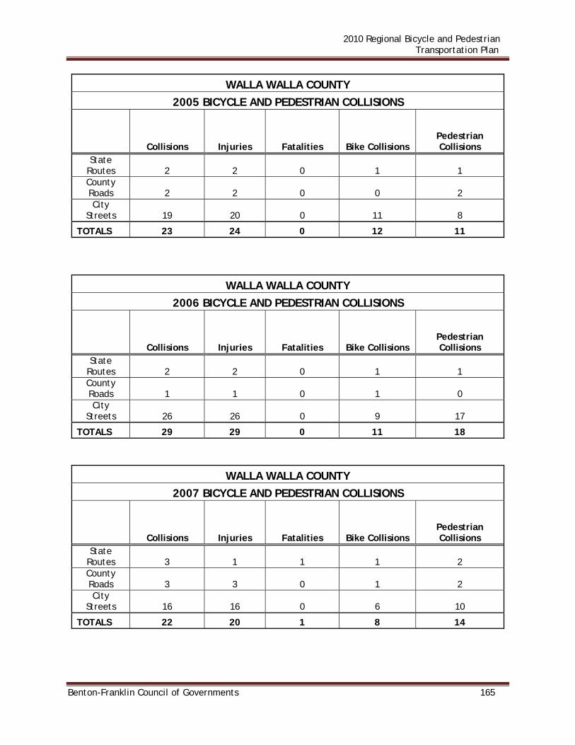
2010 Regional Bicycle and Pedestrian Transportation Plan
Benton-Franklin Council of Governments 165
WALLA WALLA COUNTY
2005 BICYCLE AND PEDESTRIAN COLLISIONS
Collisions Injuries Fatalities Bike Collisions Pedestrian Collisions
State Routes 2 2 0 1 1 County Roads 2 2 0 0 2 City
Streets 19 20 0 11 8
TOTALS 23 24 0 12 11
WALLA WALLA COUNTY
2006 BICYCLE AND PEDESTRIAN COLLISIONS
Collisions Injuries Fatalities Bike Collisions Pedestrian Collisions
State Routes 2 2 0 1 1 County Roads 1 1 0 1 0 City
Streets 26 26 0 9 17
TOTALS 29 29 0 11 18
WALLA WALLA COUNTY
2007 BICYCLE AND PEDESTRIAN COLLISIONS
Collisions Injuries Fatalities Bike Collisions Pedestrian Collisions
State Routes 3 1 1 1 2 County Roads 3 3 0 1 2 City
Streets 16 16 0 6 10
TOTALS 22 20 1 8 14

2010 Regional Bicycle and Pedestrian Transportation Plan
166 Benton-Franklin Council of Governments
WALLA WALLA COUNTY
2008 BICYCLE AND PEDESTRIAN COLLISIONS
Collisions Injuries Fatalities Bike Collisions Pedestrian Collisions
State Routes 3 3 0 3 0 County Roads 2 2 0 1 1 City
Streets 14 13 1 11 3
TOTALS 19 18 1 15 4

2010 Regional Bicycle and Pedestrian Transportation Plan
Benton-Franklin Council of Governments 167
APPENDIX C – DESIGN STANDARDS WASHINGTON STATE DEPARTMENT OF TRANSPORTATION DESIGN MANUAL Bikeway and walkway design is guided primarily by the Washington State Department of Transportation Design Manual and by national guidelines from the American Association of State Highway and Transportation Officials (AASHTO) and the Federal Highway Administration. Appendix D contains a listing of those relevant documents. Another consideration in facility design is the Americans with Disabilities Act (ADA), which requires that public and private developments provide access to all people. Furthermore, facilities should be designed to allow access by maintenance and emergency vehicles. Excerpts of the WSDOT Design Manual as it pertains to bicycle and pedestrian facilities are contained below. These sections may be viewed in their entirety at the following web address: http://www.wsdot.wa.gov/fasc/EngineeringPublications/library.htm. BICYCLE FACILITIES 1020.01 General The Washington State Department of Transportation (WSDOT) encourages multimodal use of its transportation facilities. Bicycle facilities or improvements for bicycle transportation are included in the project development and highway programming processes where bicycle use is likely and can be accommodated safely. This chapter is to serve as a guide for selecting and designing the most useful and cost-effective bicycle facility possible and for how to include the region’s Bicycle Coordinator in the design process. These guidelines apply to normal situations encountered during project development. Unique design problems are resolved on a project-by-project basis using guidance from the region’s Bicycle Coordinator. State law (46.61.710 RCW) prohibits the operation of mopeds on facilities specifically designed for bicyclists, pedestrians, and equestrians. Mopeds are not considered in the design process for the purposes of this chapter. In general, do not mix equestrian and bicycle traffic on a shared use path. Consider designing a bridle trail that is separate from the shared use path in common equestrian corridors. 1020.02 References Guide for the Development of Bicycle Facilities, 1999, AASHTO A Policy on Geometric Design of Highways and Streets (Green Book), 1994, AASHTO Manual on Uniform Traffic Control Devices (MUTCD), Federal Highway Administration (FHWA), National Advisory Committee on Standards Revised Code of Washington (RCW) 46.61, Rules of the Road; RCW 46.61.710, Mopeds, electric-assisted bicycles—General requirements and operation

2010 Regional Bicycle and Pedestrian Transportation Plan
168 Benton-Franklin Council of Governments
Standard Plans for Road, Bridge, and Municipal Construction (Standard Plans), M 21-01, WSDOT State Highway System Plan, WSDOT 1020.03 Definitions bicycle route - A system of bikeways, designated by the jurisdiction(s) having the authority, featuring appropriate directional and informational route markers. A series of bikeways may be combined to establish a continuous route and may consist of any or all types of bicycle facilities. bike lane - A portion of a highway or street identified by signs and/or pavement markings reserved for bicycle use. bikeway - Any trail, path, part of a highway or shoulder, or any other traveled way specifically signed and/or marked for bicycle travel. Category A bicyclist - Advanced or experienced riders who are generally using their bicycles as they would a motor vehicle. They want direct access to destinations with a minimum of delay and are comfortable riding with motor vehicle traffic. When touring, their vehicles are commonly heavily loaded with a tandem rider(s), children, or camping gear. They need sufficient operating space on the traveled way or shoulder to eliminate the need for them or passing vehicles to shift position. Category B bicyclist - Basic or less confident adult bicyclists who might be using their bicycles for transportation purposes. They prefer to avoid roads with fast and busy motor vehicle traffic unless there is ample roadway width. Basic bicyclists are comfortable riding on neighborhood streets and shared use paths; however, on busier streets, they prefer designated facilities such as bike lanes or wide shoulder lanes. Category C bicyclist Children, riding alone or with their parents, who need access to key destinations in the community such as schools, friends, recreational facilities, and convenience stores. Residential streets with low motor vehicle speeds (linked with shared use paths and busier streets with well-defined pavement marking between bicycles and motor vehicles) can accommodate children without encouraging them to ride in the traveled lane of major arterials. rural bicycle touring routes State highways or sections of state highways that are used or have a high potential for use by Category A bicyclists riding long distance on single or multiday trips. shared roadway A roadway that is open to both bicycle and motor vehicle travel. Shared roadways do not have dedicated facilities for bicycle travel. signed shared roadway (designated as a bike route) A shared roadway that has been designated by signing as a preferred route for bicycle use. Appropriate bike route signs are installed to assure bicyclists that improvements such as widening shoulders have been made to improve safety. shared use path A facility on exclusive right of way with minimal cross flow by motor vehicles. It is designed and built primarily for use by bicycles but is also used by pedestrians, joggers, skaters, wheelchair users (both nonmotorized and motorized), and others.

2010 Regional Bicycle and Pedestrian Transportation Plan
Benton-Franklin Council of Governments 169
1020.04 Planning (1) General Bikeway planning includes provisions and facilities for safe and efficient bicycle travel. An effective multimodal transportation program addresses the issue of upgrading highways to accommodate shared use by bicyclists and motorists. Bicyclists of all skill levels will use well designed facilities. Bicyclists will avoid a poorly designed facility. To enhance bicycle travel, consider upgrading existing roads that are used regularly by Category A or B bicyclists. The upgrading includes improving the width and quality of the surface and maintaining the right-hand portion in a condition suitable for bicycle riding. Consider bicycle facilities when designing construction projects and normal safety and operational improvements. Shoulder widening projects along existing highways, might be an opportunity to encourage bicycle traffic and enhance bicycle safety. Correcting short areas of restricted width (such as bridges, cuts, or fills) to provide bikeways might not be cost effective. However, the presence of these short, restricted areas does not diminish the importance of widening the adjoining shoulder sections. Bikeway planning is an integral part of the facility planning for other transportation modes and land use development. Use the location criteria that follow for long-term planning and project development as applicable. (2) Programming The State Highway System Plan identifies two elements of bicycle project funding: • Urban Bicycle Projects: Complete local bicycle networks by building short sections of appropriate bicycle facilities along or across state highways. • Rural Bicycle Touring Routes: Shoulder improvements along sections of designated state routes. Urban Bicycle Projects have been prioritized by the region’s Planning Offices, the OSC Bicycle Program, and the department’s Bicycle Advisory Committee and are listed in the State Highway System Plan. Urban Bicycle Projects are selected in each region, prioritized, and will compete for funding. Rural Bicycle Touring Routes (RBTR) programming priority areas are listed in the State Highway System Plan. Each region’s Planning Office has a map with the priority areas marked. The purpose of the RBTR program is to add funding to a project in an RBTR shoulder deficiency area. Designers are to consult the region’s Planning Office to determine if their project is within an RBTR shoulder deficiency area. If the project is within an RBTR shoulder deficiency area, the designer requests the region’s Program Management to determine RBTR funding availability. Consider spot bikeway improvements in other types of projects such as P1 paving and I2 safety improvement projects. Identify small improvements in the project definition phase. Consult the region’s Bicycle Coordinator for recommendations and the limits of the work. Funding from other sources such as the Urban Bicycle and Rural Bicycle programs might be available.

2010 Regional Bicycle and Pedestrian Transportation Plan
170 Benton-Franklin Council of Governments
(3) Selection of the Type of Facility In selecting an appropriate facility, ensure that the proposed facility will not encourage or require bicyclists or motorists to operate in a manner that is inconsistent with the Rules of the Road (RCW 46.61). An important consideration is route continuity. Alternating bikeways from side to side along a route is generally unacceptable. Designing a route that requires bicyclists to cross the roadway could result in inappropriate maneuvers and/or encourage Rules of the Road violations. In addition, wrong-way bicycle travel might occur beyond the ends of shared use paths because of the inconvenience of having to cross the street. Many factors are involved in determining which type of facility will benefit the greatest number of bicyclists. Outlined below are the most common applications for each type. (a) Shared Use Path. The most common applications for shared use paths are along rivers and streams, ocean beachfronts, canals, utility rights of way, and abandoned railroad rights of way; within college campuses; and within and between parks. There might also be situations where such facilities can be provided as part of planned developments. Another common application of shared use paths is to close gaps in bicycle travel caused by construction of freeways, or the existence of natural barriers (rivers, mountains, and other large geographic features). Generally, shared use paths are used to serve corridors not served by streets and highways or where wide rights of way exist permitting such facilities to be constructed away from the influence of parallel roadways. Shared use paths offer opportunities not provided by the road system. They can either provide a recreational opportunity or serve to minimize motor vehicle interference by providing direct high-speed bicycle commute routes. (b) Bike Lane. Bike lanes are established along streets in corridors where there is or, in the future, might be significant bicycle demand. Bike lanes delineate the rights of way assigned to bicyclists and motorists and provide for movements that are more predictable by each. An important reason for establishing bike lanes is to better accommodate bicyclists through corridors where insufficient room exists for safe bicycling on existing streets. This can be accomplished by reducing the number of lanes or prohibiting parking in order to delineate bike lanes. Where street improvements are not possible, improve the bicyclist’s environment by providing shoulder sweeping programs and special signal facilities. When considering the selection of appropriate streets for bike lanes, refer to the location criteria discussed in 1020.04(4). Do not designate sidewalks as bike lanes. (c) Shared Roadway. Most bicycle travel in Washington occurs on highways and streets without bikeway designations. In most instances, entire street systems are fully adequate for safe and efficient bicycle travel and signing and pavement markings for bicycle use are unnecessary. The region’s traffic is responsible for determining sections of state highways where bicycle
2010 Regional Bicycle and Pedestrian Transportation Plan
Benton-Franklin Council of Governments 171
traffic is inappropriate. The State Traffic Engineer, after consultation with the Bicycle Advisory Committee, prohibits bicycling on sections of state highways through the traffic regulation process. Also, see Chapter 1420 “Access Control Design Policy”. Bicyclists traveling between cities, or on recreational trips, may use many rural highways. In most cases, rural highways are not designated as bike routes because of the limited use and the lack of continuity with other bike routes. However, the development and maintenance of paved shoulders, with or without a standard edge stripe, can significantly improve safety and convenience for bicyclists and motorists along such routes. (d) Signed Shared Roadway. Designate signed shared roadways as bike routes by posting bike route signs. These routes provide continuity to other bicycle facilities and designate preferred routes through high bicycle demand corridors. As with bike lanes, designating shared roadways as bike routes is an indication to bicyclists that there are particular advantages to using these bike routes as compared with alternative routes. This means that the responsible agencies have taken action to ensure that these routes are suitable as bike routes and are maintained in a manner consistent with the needs of bicyclists. Signing also alerts motor vehicle operators that bicycles are present. Use the following criteria to aid in determining whether or not to designate and sign a bike route: • The route offers a higher degree of service than alternative streets. • It provides for through and direct travel in bicycle-demand corridors. • It connects discontinuous segments of bikeways. • Traffic control devices have been adjusted to accommodate bicyclists. • Street parking is restricted for improved safety where lane width is critical. • Surface hazards to bicyclists have been corrected. • Maintenance of the route is to a higher standard than comparable streets, such as more frequent street sweeping and repair. In general, do not designate sidewalks as bikeways for the following reasons: • Sidewalks tend to be used in both directions, despite any signing to the contrary. • At approaches to intersections, parked cars might impede sight distance of motorists and bicyclists. At driveways, property fences, shrubs, and other obstructions often impair sight distances. • At intersections, motorists are not looking for bicyclists entering the crosswalk area, particularly when motorists are making a turn. • Sidewalks are typically designed for pedestrian speeds, and might not be safe for higher-speed use. Conflicts between bicyclists and pedestrians are common, as are conflicts with fixed objects such as parking meters, utility poles, signposts, bus shelters, benches, trees, hydrants, and mailboxes. In addition, bicyclists riding on the curb side of sidewalks might accidentally drop off the sidewalk into the path of motor vehicle traffic. Only consider a sidewalk as a bike route under special circumstances, such as on long, narrow bridges. Even then, the preferred solution is to widen the roadway to provide space for bicyclists. In residential areas, sidewalk riding is commonly done by Category B and C bicyclists who are not comfortable riding in the street. However, it is inappropriate to sign these facilities as bike routes.

2010 Regional Bicycle and Pedestrian Transportation Plan
172 Benton-Franklin Council of Governments
(4) Location Criteria Factors to consider in determining the location of a bikeway are: (a) Potential Use. Locate bikeways along corridors or a convenient road parallel to the corridor to maximize use. However, to attract commuting bicyclists, the roadway must offer through route conditions. (b) Directness. Locate facilities along a direct line and in such a way that they connect bicycle traffic generators for the convenience of the users. Bicyclists are interested in the same destinations as motorists. (c) Access. When locating a shared use path, provide adequate access points. The more access points, the more the facility will be used. Adequate access for emergency and service vehicles is also necessary. (d) Shared Use Path Widths. Figure 1020-13 shows the widths and minimum horizontal clearances needed when a shared use path is on an alignment separate from a highway right of way. Figure 1020-14 shows shared use path width when adjacent to a roadway and within its right of way. See 1020.05(2)(e) to find if a barrier will be needed. (e) Available Roadway Width. For a bike lane or shared roadway (with or without signing), the overall roadway width must meet or exceed the highway minimum design criteria. See Chapter 430 “Modified Design Level” and 440 “Full Design Level” and Figures 1020-14 and 1020-15 for further width information. (f) On-Street Motor Vehicle Parking. Consider the density of on-street parking and the safety implications, such as opening car doors. If possible, select a route where on-street parking is light or where it can be prohibited. (g) Delays. Bicyclists have a strong desire to maintain momentum. If bicyclists are required to make frequent stops, they might avoid the route. (h) Traffic Volumes and Speeds. For an on-street bikeway, the volume and speed of auto traffic, along with the available width, are factors in determining the best location. Commuting bicyclists generally ride on arterial streets to minimize delay and because they are normally the only streets offering continuity for trips of several miles. The FHWA has developed a spreadsheet to evaluate roadways for bicycle compatibility. The Bicycle Compatibility Index (BCI) measures roadways based on traffic volume, speed, lane width, and other factors. A copy of the BCI and supporting information is found at http://www.hsrc.unc.edu/research/pedbike/bci/index.html . (i) Truck and Bus Traffic. High-speed truck, bus, and recreational vehicle traffic can cause problems along a bikeway because of aerodynamic effects and vehicle widths. Evaluate the need to widen shoulders or change the location of the bicycle facility if it is on a roadway with this type of traffic. (j) Existing Physical Barriers. In some areas there are physical barriers to bicycle travel

2010 Regional Bicycle and Pedestrian Transportation Plan
Benton-Franklin Council of Governments 173
caused by topographical features such as rivers, limited access highways, or other impediments. In such cases, developing a facility that allows a bikeway to cross an existing barrier can provide access opportunities for bicyclists. (k) Collision History. Check the collision experiences along a prospective bicycle route to determine its relative safety compared to other candidate routes. This involves analysis of the collision types to determine which of them might be reduced. (See 1020.04(4)(p).) Consider both the impacts caused by adding bicycle traffic and the potential for introducing new accident problems. The region’s Traffic Office is a good resource when considering collision factors. (l) Grades. Avoid steep grades on bikeways whenever possible. Refer to 1020.05(2)(k) for specific criteria. (m) Pavement Surface Quality. Establish an on-street bikeway only where pavement can be brought to a reasonable condition for safe bicycle travel. Dense graded asphalt concrete surfaces are preferable to open-graded asphalt concrete, Portland cement concrete, and seal-coated surfaces. (n) Maintenance. Ease of maintenance is an important consideration in locating and developing a bikeway. Consider the ease of access by maintenance vehicles. Bicyclists will often shun a poorly maintained bikeway in favor of a parallel roadway. Consult with area maintenance personnel during the planning stage. (o) Environmental Compatibility. Consider scenic value, erosion and slope stability, and compatibility with the surrounding terrain when developing a bikeway. Provide landscaping to minimize adverse environmental effects. (p) Use Conflicts. Different types of facilities produce different types of conflicts. On-street bikeways involve conflicts with motor vehicles. Shared use paths usually involve conflicts with other bicyclists, pedestrians, skaters, and runners on the path, and with motor vehicles at street intersections. Conflicts between bicyclists and motorists can also occur at highway and driveway intersections, tight corners, and narrow facilities like bridges and tunnels. (q) Security. The potential for criminal acts against bicyclists and other users of bikeways exists anywhere, especially along remote stretches. There also is the possibility of theft or vandalism at parking locations. Consult local law enforcement agencies for guidance in making these areas safer. Also consider installation of telephones in high risk areas. (r) Cost/Funding. Location selection will normally involve a cost comparison analysis of alternatives. Funding availability will often eliminate some alternatives; however, it is more desirable to delay constructing a bicycle facility than to construct an inadequate facility. (s) Structures. Continuity can be provided to shared use path by using an overpass, underpass, tunnel, bridge, or by placing the facility on a highway bridge to cross obstacles. See 1020.05(2)(m) for design information. Retrofitting bicycle facilities on existing bridges involves a large number of variables; compromises in desirable design criteria are often inevitable. The planner, with the

2010 Regional Bicycle and Pedestrian Transportation Plan
174 Benton-Franklin Council of Governments
assistance of the region’s Bicycle Coordinator and the Bridge and Structures Office, on a case-by- case basis, will determine the desirable design criteria. Consider the following alternatives when placing a shared use path on an existing highway bridge: • On one side of a bridge. Do this where: the bridge facility connects at both ends to the path; there is sufficient width on that side of the bridge or additional width can be gained by remarking the pavement; and provisions have been made to physically separate the motor vehicle traffic from the bicycle traffic. • Provide bicycle lanes, shoulders, or wide curb lanes over a bridge. This is advisable where: bike lanes and shoulders connect on either end of the structure, and when sufficient width exists or can be obtained by widening or remarking the pavement. Use this option only if the bike lane or wide outside lane can be accessed without increasing the potential for wrong-way riding or inappropriate crossing movements. (v) Lighting. Illumination of bicycle facilities might be necessary to achieve minimum levels of safety, security, and visibility. (w) Support Facilities. Where bicycles are used extensively for utility trips or commuting, consider placing adequate bicycle parking and/or storage facilities at common destinations (such as park and ride lots, transit terminals, schools, and shopping centers). Contact the region’s Bicycle Coordinator for additional information.
PEDESTRIAN DESIGN CONSIDERATIONS 1025.01 General Pedestrians are present on most highways and transportation facilities, yet their travel mode differs vastly and sometimes is in conflict with the requirements for vehicular travel. The challenge is to provide safe and efficient facilities that address these two competing interests within a limited amount of right of way. Sidewalks and trails serve as critical links in the transportation network. Facilities that encourage pedestrian activities are a part of comprehensive transportation planning and development programs for urban and rural communities. 1025.02 References Design Guidance, Accommodating Bicycle and Pedestrian Travel. A Recommended Approach, USDOT Policy Statement, 2001 Manual on Uniform Traffic Control Devices for Streets and Highways (MUTCD), USDOT, Washington DC, 1988, including the Washington State Modifications to the MUTCD, M 24-01, WSDOT, 1996 RCW 46.04.160, "Crosswalk" RCW 46.61.240, "Crossing at other than crosswalks" RCW 47.24.010, City streets as part of state highways, "Designation-construction, maintenance-return to city or town" RCW 47.24.020, City streets as part of state highways, "Jurisdiction, control" Roadside Manual M 25-30, WSDOT Sidewalk Details, WSDOT, 2000

2010 Regional Bicycle and Pedestrian Transportation Plan
Benton-Franklin Council of Governments 175
Standard Plans for Road, Bridge, and Municipal Construction (Standard Plans), M 21-01, WSDOT Pedestrian Facilities Guidebook: Incorporating Pedestrians into Washington's Transportation System, OTAK, 1997 1025.03 Definitions accessible route - An unobstructed pedestrian route that meets the requirements of the Americans with Disabilities Act accessibility guidelines. ADA - An abbreviation for the Americans with Disabilities Act of 1990. The ADA is a civil rights law that identifies and prohibits discrimination based on disability. The ADA requires public entities to design new facilities or alter existing facilities, including sidewalks and trails that are accessible to people with disabilities. Preservation projects, usually, are not considered an alteration of existing facilities. Accessibility can be addressed in preservation projects as a spot safety improvement. bulb out - A curb and sidewalk bulge or extension out into the roadway used to decrease the length of a pedestrian crossing. crosswalk - That marked or unmarked portion of a roadway designated for a pedestrian crossing. landing - A level area at the top of a pedestrian ramp. midblock pedestrian crossing - A marked pedestrian crossing located between intersections. pedestrian facilities - Walkways such as sidewalks, highway shoulders, walking and hiking trails, shared use paths, pedestrian grade separations, crosswalks, and other improvements provided for the benefit of pedestrian travel. pedestrian-friendly - A term for an environment that is safe, pleasant, and inviting to pedestrians. pedestrian refuge island - A raised area between traffic lanes that provides a place for pedestrians to wait to cross the street. raised median - A raised island in the center of a road used to restrict vehicle left turns and side street access. Pedestrians often use this median as a place of refuge when crossing a roadway. 1025.04 Policy (1) General Pedestrian facilities are required along and across most sections of state routes and are an integral part of the transportation system. Walkways and other pedestrian facilities are considered in the project definition phase. The only factors that will preclude providing pedestrian facilities in a project are as follows: • Pedestrians are prohibited by law from using the facility. • The cost of the improvements is excessive and disproportionate to the original need or
probable use (as a guide, more than 20% of the original estimate). • Low population density or other factors indicate that there is no need.
(2) Funding Programs The adequacy of appropriate pedestrian facilities is addressed in mobility, safety, bridge
2010 Regional Bicycle and Pedestrian Transportation Plan
176 Benton-Franklin Council of Governments
replacement, and economic initiative projects in both the Highway Capitol Improvement and Preservation Programs. Federal, state, and local funds are available for pedestrian facility projects. (a) Improvement Program Mobility Program (1-1). Pedestrian facilities are included in improvement projects in urban areas unless the facility is restricted to motor vehicle use. In urban areas, pedestrian facilities can include traffic control devices, grade separations, crosswalks, sidewalks, and illumination. Other technologies, design features, or strategies, such as creating a pedestrian-friendly atmosphere, are generally beyond the scope of usual highway construction projects. These design features, however, can be included in a highway project when a local agency desires to participate and can provide the necessary funding. Partnership agreements between the state and local agencies to provide pedestrian amenities are effective ways to address seemingly different goals. In rural areas, paved roadway shoulders are usually sufficient as pedestrian facilities. In high pedestrian use areas adjacent to the highway (state parks, recreation areas, and public-owned parking lots) additional signing, marked crosswalks, and separate pedestrian paths and trails might be necessary. Separate pedestrian paths or trails are appropriate, in some circumstances, as connections between activity centers or as part of a comprehensive trails plan. Safety Program (1-2). Pedestrian Accident Locations (PALs) are sections of state routes with four or more pedestrian collisions with vehicles in a six-year period. PALs usually have a high societal cost and compete favorably with High Accident Locations (HALs) for safety funding. Pedestrian Risk Projects are sections of state highways that have a high risk of pedestrian collisions with vehicles based on adjacent land use, roadway geometric design, and traffic conditions. Each region has a funding allotment to address pedestrian risk locations. Short sections of sidewalks, illumination, raised medians, and other pedestrian facilities are eligible for safety funding where there are pedestrian collisions, such as part of PAL or a High Accident Corridor (HAC). Economic Initiatives (1-3). Projects supporting tourism development, promoting the interpretation of heritage resources, and ensuring public access to rest room equipped facilities can include limited pedestrian facility improvements if the site generates pedestrian activity. (b) Preservation Program Roadway Program (P-l). Projects funded by the Highway Capitol Preservation Program usually do not include enhancement of existing pedestrian facilities except as minor pedestrian spot safety improvements. Other funding sources, including local agency participation through federal grants, can be used for sidewalks, walkways, or other pedestrian facilities in these projects. Structures Program (P-2). Bridge replacement funding can be used to replace existing pedestrian facilities or to match shoulder width or sidewalks of adjacent roadways on bridges. Other Facilities (P-3). This funding source can be used to refurbish pedestrian facilities and address ADA requirements within existing rest areas. (3) Project Requirements For urban mobility improvement projects (Pedestrian connectivity projects in the matrices, Chapter 325), apply the guidance in this chapter to the pedestrian facility.

2010 Regional Bicycle and Pedestrian Transportation Plan
Benton-Franklin Council of Governments 177
For highway design elements affected by the project, apply the appropriate design level (Chapter 325) and design requirements in the applicable Design Manual chapters. For highway design elements not affected by the project, no action is required. 1025.05 Pedestrian Human Factors Understanding the human behavior of pedestrians aids in the design of effective facilities. Young children tend to dart out into traffic because they have no understanding of vehicle stopping distances or sight limitations. Older children and teenagers are more likely to cross midblock, or step out in front of oncoming traffic. Adults are more capable of perceiving and dealing with risk. Senior adults and persons with disabilities are most likely to obey crosswalk laws and make predictable movements. Senior pedestrians, as a group, also tend to have reduced vision, balance, speed, stamina, and have trouble distinguishing objects in low light and nighttime conditions. Walking rates are an important consideration in intersection design. The average walking speed for pedestrians is 4 feet per second. Actual walking speeds, however, can vary from 2.4 to 6.0 feet per second depending on the age group. In addition, people with disabilities require more time to cross a roadway. In areas with a higher senior adult population, a walking rate of 3.0 feet per second is more realistic. This can be mitigated at locations with traffic signals by providing longer pedestrian signal timings, or pedestrian refuge areas, such as islands and medians. Factors that contribute to deterring pedestrian travel include: • High vehicle volumes and speeds • Lack of separated pedestrian facilities • Lack of a continuous walkway system (missing links) • Poor nighttime lighting • Lack of connections to pedestrian activity generators • Inaccessible to people with disabilities • Concerns for personal safety • Barriers on walking route (rivers, railroads, bridges without sidewalks) • Narrow walkway width • Lack of transit shelter
To encourage multimodal transportation, livable communities, and pedestrian safety, many agencies provide pedestrian-friendly features along their streets, roads, and highways. The following are several pedestrian-friendly practices in current use: • ADA accessible routes • More direct alignment of walkways to reduce travel distances • A complete network of pedestrian connections • Ramps and handrails for persons with disabilities • Medians and pedestrian refuge islands • Buffers between the walkway and roadway • Lower vehicular speeds • Adequate pedestrian signs, signals, and markings • Pedestrian furniture and vegetation • Bulb outs or curb extensions • Adequate illumination • Audible warning signal

2010 Regional Bicycle and Pedestrian Transportation Plan
178 Benton-Franklin Council of Governments
1025.06 Pedestrian Activity Generators The types of land uses that indicate high pedestrian activity are residential developments with four or more housing units per acre interspersed with multifamily dwellings or hotels located within 1/2 mile of other attractions. These attractions might be retail stores, schools, recreation areas, or senior citizen centers. Certain types of businesses, such as "deli-mart" type stores, fast food restaurants, and skateboard parks, can cater to a specific pedestrian age group and generate high activity levels. Information on land use, development, and estimated pedestrian densities is available from metropolitan planning organizations, region planning offices, and city and county planning department comprehensive plans. School districts designate walking routes for every elementary school. In general, children within one mile of the school are required to walk unless there are hazardous walking conditions. Contact the school district's safely manager to determine the walking routes, average student age, transit stops, and the distance from the school to attractions. Sports, school plays, and other special events occurring after normal school hours can also generate exceptionally high levels of pedestrian activity. Consider the impact of these events when providing pedestrian facilities. 1025.07 Pedestrian Facility Design (1) Facilities The type of pedestrian facility provided is based on local transportation plans, the roadside envi-ronment, pedestrian volumes, user age group, safety-economic analysis, and continuity of local walkways along or across the roadway. Sidewalks can be either immediately adjacent to streets and highways or separated from them by a buffer. Walking trails, hiking trails, and shared use paths are independently aligned and generally serve recreational activities. The type of walkway also depends on the access control of the highway as follows: Full Access Control. Walking and hiking trails and shared use paths within the right of way are separated from vehicular traffic with physical barriers that discourage pedestrians from entering the roadway. These trails can connect with other trails outside the right of way if the access permit is modified. Grade separations are provided when the trail crosses the highway. Partial or Modified Access Control. Walking and hiking trails and shared use paths are located between the access points of interchanges or intersections. Pedestrian crossings are usually either at-grade with an intersecting cross road or a grade separation. Midblock pedestrian crossings can be considered at pedestrian generators when the roadway has predominately urban characteristics. Managed Access Control. In rural areas, paved shoulders are usually used for pedestrian travel. When pedestrian activity is high, separate walkways are provided. Sidewalks are used in urban areas where there is an identified need for pedestrian facilities. Trails and paths, separated from the roadway alignment, are used to connect areas of community development. Pedestrian crossings are at-grade.
Further Information and Resources
General Design Resources
A Policy on Geometric Design of Highways and Streets, 1994 (The Green Book). American Association of State Highway and Transportation Officials (AASHTO), P.O. Box 96716,

2010 Regional Bicycle and Pedestrian Transportation Plan
Benton-Franklin Council of Governments 179
Washington, DC, 20090-6716, Phone: (888) 227-4860.
Highway Capacity Manual, Special Report 209, 1994. Transportation Research Board, Box 289, Washington, DC 20055, Phone: (202) 334-3214. Next Edition: FHWA Research Program project has identified changes to HCM related to bicycle and pedestrian design.
Manual on Uniform Traffic Control Devices, 1988. Federal Highway Administration (FHWA), Superintendent of Documents. P.O. Box 371954, Pittsburgh, PA 15250-7954. Next Edition: 2000, will incorporate changes to Part IX that will soon be subject of Notice of Proposed Rulemaking.
Flexibility in Highway Design, 1997. FHWA. HEP 30, 400 Seventh Street SW, Washington, DC 20590.
Pedestrian Facility Design Resources
Design and Safety of Pedestrian Facilities, A Recommended Practice, 1998. Institute of Transportation Engineers, 525 School Street, S.W, Suite 410, Washington, DC 20024-2729, Phone: (202) 554-8050.
Pedestrian Compatible Roadways-Planning and Design Guidelines, 1995. Bicycle / Pedestrian Transportation Master Plan, Bicycle and Pedestrian Advocate, New Jersey Department of Transportation, 1035 Parkway Avenue, Trenton, NJ 08625, Phone: (609) 530-4578.
Improving Pedestrian Access to Transit: An Advocacy Handbook, 1998. Federal Transit Administration / WalkBoston. NTIS, 5285 Port Royal Road, Springfield, VA 22161.
Planning and Implementing Pedestrian Facilities in Suburban and Developing Rural Areas, Report No. 294A, Transportation Research Board, Box 289, Washington, DC 20055, Phone: (202) 334-3214.
Pedestrian Facilities Guidebook, 1997. Washington State Department of Transportation, Bicycle and Pedestrian Program, P.O. Box 47393, Olympia, WA 98504.
Portland Pedestrian Design Guide, 1998. Portland Pedestrian Program, 1120 SW Fifth Ave, Room 802; Portland, OR 97210. (503) 823-7004.
* Implementing Pedestrian Improvements at the Local Level, 1999. FHWA, HSR 20, 6300 Georgetown Pike, McLean, VA .
* AASHTO Guide to the Development of Pedestrian Facilities, 2000. AASHTO. (currently under discussion)
Bicycle Facility Design Resources
Guide for the Development of Bicycle Facilities, 1999., American Association of State Highway and Transportation Officials (AASHTO), P.O. Box 96716, Washington, DC, 20090-6716, Phone: (888) 227-4860.

2010 Regional Bicycle and Pedestrian Transportation Plan
180 Benton-Franklin Council of Governments
Implementing Bicycle Improvements at the Local Level, (1998), FHWA, HSR 20, 6300 Georgetown Pike, McLean, VA .
Bicycle Facility Design Standards, 1998. City of Philadelphia Streets Department, 1401 JFK Boulevard, Philadelphia, PA 19103.
Selecting Roadway Design Treatments to Accommodate Bicyclists, 1993. FHWA, R&T Report Center, 9701 Philadelphia Ct, Unit Q; Lanham, MD 20706. (301) 577-1421 (fax only)
North Carolina Bicycle Facilities Planning and Design Guidelines, 1994. North Carolina DOT, P.O. Box 25201, Raleigh, NC 27611. (919) 733-2804.
Bicycle Facility Planning, 1995. Pinsof & Musser. American Planning Association, Planning Advisory Service Report # 459. American Planning Association, 122 S. Michigan Ave, Suite 1600; Chicago, IL 60603.
Florida Bicycle Facilities Planning and Design Manual, 1994. Florida DOT, Pedestrian and Bicycle Safety Office, 605 Suwannee Street, Tallahassee, FL 32399.
Evaluation of Shared-use Facilities for Bicycles and Motor Vehicles, 1996. Florida DOT, Pedestrian and Bicycle Safety Office, 605 Suwannee Street, Tallahassee, FL 32399.
Bicycle and Pedestrian Design Resources
Oregon Bicycle and Pedestrian Plan, 1995. Oregon Department of Transportation, Bicycle and Pedestrian Program, Room 210, Transportation Building, Salem, OR 97310, Phone: (503) 986-3555
Improving Conditions for Bicyclists and Pedestrians, A Best Practices Report, 1998. FHWA, HEP 10, 400 Seventh Street SW, Washington, DC 20590.
Traffic Calming Design Resources
Traffic Calming: State of the Practice. 1999. Institute of Transportation Engineers, 525 School Street, SW, Suite 410; Washington, DC 20024.
Florida Department of Transportation's Roundabout Guide. Florida Department of Transportation, 605 Suwannee St., MS-82, Tallahassee, FL 23299-0450.
National Bicycling and Walking Study. Case Study # 19, Traffic Calming and Auto-Restricted Zones and other Traffic Management Techniques-Their Effects on Bicycling and Pedestrians, Federal Highway Administration (FHWA).
Traffic Calming (1995), American Planning Association, 122 South Michigan Avenue, Chicago, IL 60603
Traditional Neighborhood Development Street Design Guidelines, 1997. Proposed Recommended Practice, Institute of Transportation Engineers, 525 School Street, SW, Suite

2010 Regional Bicycle and Pedestrian Transportation Plan
Benton-Franklin Council of Governments 181
410; Washington, DC 20024.
Making Streets that Work, City of Seattle, 600 Fourth Ave., 12th Floor, Seattle, WA 98104-1873, Phone: (206) 684-4000, Fax: (206) 684-5360.
Traffic Control Manual for In-Street Work, 1994. Seattle Engineering Department, City of Seattle, 600 4th Avenue, Seattle, WA 98104-6967, Phone: (206) 684-5108.
ADA-related Design Resources
Accessible Pedestrian Signals, 1998. U.S. Access Board 1331 F Street NW, Suite 1000; Washington, DC 20004. (800) 872-2253.
Accessible Rights of Way: A Design Manual,1999. U.S. Access Board, 1331 F Street NW, Suite 1000; Washington, DC 20004. (800) 872-2253.
Designing Sidewalks and Trails for Access, Part One. 1999. FHWA, HEPH-30, 400 Seventh Street SW, Washington, DC 20590.
ADA Accessibility Guidelines for Buildings and Facilities, 1998 (ADAAG). U.S. Access Board, 1331 F Street NW, Suite 1000; Washington, DC 20004. (800) 872-2253.
Uniform Federal Accessibility Standards, 1984 (UFAS), available from the U.S. Access Board, 1331 F Street NW, Suite 1000; Washington, DC 20004. (800) 872-2253
Universal Access to Outdoor Recreation: A Design Guide, 1993. PLAE, Inc, MIG Communications, 1802 Fifth Street, Berkeley, CA 94710. (510) 845-0953.
Recommended Street Design Guidelines for People Who Are Blind or Visually Impaired. American Council of the Blind, 1155 15th Street NW, Suite 720; Washington, DC 20005. (202) 467-5081.
Trail Design Resources
Trails for the 21st Century, 1993. Rails to Trails Conservancy, 1100 17th Street NW, 10th Floor, Washington DC 20036. (202) 331-9696.
Greenways: A Guide to Planning, Design, and Development, 1993. The Conservation Fund. Island Press, 1718 Connecticut Ave NW, Suite 300; Washington, DC 20009.
Trail Intersection Design Guidelines, 1996. Florida Department of Transportation, 605 Suwannee St., MS-82, Tallahassee, FL 23299-0450.

2010 Regional Bicycle and Pedestrian Transportation Plan
182 Benton-Franklin Council of Governments
APPENDIX D - THE BICYCLE COMPATIBILITY INDEX: A LEVEL OF SERVICE CONCEPT The FHWA Pedestrian and Bicycle Safety Research Program focuses on identifying problem areas for pedestrians and bicycles; developing analysis tools that allow planners and engineers to better understand and target these problem areas; and evaluating countermeasures to reduce the number of crashes involving pedestrians and bicycles. A recent FHWA Pedestrian and Bicycle Safety Research Program accomplishment was development of the Bicycle Compatibility Index (BCI) and Level of Service (LOS) designations “A” through “F” for bicycles. The BCI is a method to determine the compatibility of a roadway for efficient operation of both bicycles and motor vehicles. It can be used to evaluate the need for improvements on existing facilities as well as determine the geometric and operational requirements for new facilities to achieve the desired level of bicycle service. The BCI model is applicable to urban and suburban roadway segments (i.e., midblock locations that are exclusive of major intersections). Determining how traffic operations and geometric conditions impact a bicyclist’s decision to use or not use a specific roadway is the first step in determining the bicycle compatibility of that roadway. The BCI can be used to evaluate the need for improvements on existing facilities as well as determine the geometric and operational requirements for new facilities to achieve the desired level of bicycle service. The BCI model is applicable to urban and suburban roadway segments (i.e., mid-block locations that are exclusive of major intersections) and incorporates variables that bicyclists typically use to assess the “bicycle friendliness” of a roadway (e.g., curb, lane width, traffic volume, and vehicle speeds). The model predicts the overall comfort level rating of a bicyclist using eight significant variables and an adjustment factor to account for three additional operational characteristics. The basic model (excluding the adjustment factor) has an R² value of 0.89, indicating that 89 percent of the variance of the index or comfort level of the bicyclist is explained by the eight variables included in the model. In other words, the model is a reliable predictor of the expected comfort level of bicyclists on the basis of these eight variables describing the geometric and operational conditions of the roadway. The variable with the largest effect on the index is the presence or absence of a bicycle lane or paved shoulder that is at least 0.9 m wide (about 3 feet). The presence of a bicycle lane (paved shoulder) reduces the index by almost a full point, indicating an increased level of comfort for the bicyclist. Increasing the width of the bicycle lane or paved shoulder or the curb lane also reduces the index as does the presence of residential development along the roadside. On the other hand, an increase in traffic volume or motor vehicle speeds increases the index, indicating a lower level of comfort for the bicyclist. The presence of on-street parking also increases the index. The adjustment factor accounts for three specific operating conditions shown to also negatively impact the comfort level of bicyclists, namely the presence of: 1) large trucks or buses; 2) vehicles turning right into

2010 Regional Bicycle and Pedestrian Transportation Plan
Benton-Franklin Council of Governments 183
driveways or minor intersections; or 3) vehicles pulling into or out of on-street parking spaces. LEVEL OF SERVICE FOR BICYCLING
TABLE 60 BICYCLE COMPATIBILITY INDEX (BCI) RANGES ASSOCIATED WITH
LEVEL OF SERVICE (LOS) DESIGNATIONS AND COMPATIBILITY LEVEL QUALIFIERS. There are no level of service (LOS) criteria presently provided in the Highway Capacity Manual. However, the definition of the LOS according to the manual is founded on the concept of users perceptions of qualitative measures that characterize the operational conditions of the roadway. Two of the terms used in the manual to describe LOS are comfort/convenience and freedom to maneuver. Both of these terms are applicable to bicyclists and are directly reflected in the BCI since the rating scale used by the study participants was an indication of comfort level. Thus, using the BCI values produced from the set of locations included in the study, LOS designations were established for LOS “A” through LOS “F” as shown in Table B-1. BCI APPLICATIONS The BCI model and the subsequent LOS designations provide the capability to better plan for and design roadways that are bicycle compatible. Specifically, the BCI model can be used for the following applications: Operational Evaluation. Existing roadways can be evaluated using the BCI model to
determine the bicycle LOS present on all segments. This type of evaluation may be useful in several ways. First, a bicycle compatibility map can be produced for the bicycling public to assist them in making informed decisions regarding route selection. Second, the most appropriate routes for inclusion in the community bicycle network can be identified. In addition, “weak links” in the network can be determined and prioritization of sites needing improvements can be established based on the index values. Finally, alternative treatments (e.g., addition of a bicycle lane versus removal of parking) for improving the bicycle compatibility of a roadway can be evaluated.
Design. New roadways or roadways being re-designed or retrofitted can be assessed to
determine if they are bicycle compatible. The planned geometric parameters and predicted or known operational parameters can be used as inputs to the model to produce the BCI value and to determine the bicycle LOS that can be expected to occur. If the roadway does not meet the desired LOS, the model can be used to evaluate changes in the design necessary to improve the bicycle LOS.
LOS BCI Range Compatibility Level A < 1.50 Extremely High B 1.51 – 2.30 Very High C 2.31 – 3.40 Moderately High D 3.41 – 4.40 Moderately Low E 4.41 – 5.30 Very Low F > 5.30 Extremely Low

2010 Regional Bicycle and Pedestrian Transportation Plan
184 Benton-Franklin Council of Governments
Planning. Data from long-range planning forecasts can be used to assess the bicycle
compatibility of roadways in the future using projected volumes and planned roadway improvements. the model provides the user with a mechanism to quantitatively define and assess long-range bicycle transportation plans.
BCI AND LOS WORKBOOK The BCI and LOS criteria have been incorporated into a Microsoft Excel workbook to simplify using the model in real-world applications. The workbook contains three separate worksheets, which are linked together to produce the BCI and LOS results. The Data Entry Worksheet allows the user to enter location information, geometric and roadside data, traffic operations data, and parking data. The Intermediate Calculations Worksheet calculates the adjustment factors and makes several other key computations using the raw data. Finally, the BCI and LOS Computations Worksheet calculates the BCI using the nine variable that make up the model and provides the bicycle LOS compatibility level. AVAILABILITY OF REPORTS AND WORKBOOK The results of this research effort are documented in two reports published in December 1998. The first is the final report (FHWA-RD-98-072), which documents the research project, including a comprehensive literature review, field data collection procedures, and results of the data analysis. The second is an implementation manual (FHWA-RD-98-095), which provides practitioners with a guide to using the BCI instrument along with several real-world examples. Both documents are on the web at www.hsrc.un.edu/research/pedbike/bcil. The BCI workbook that can be used for entering data and producing BCI and LOS results can be downloaded from the same site.

2010 Regional Bicycle and Pedestrian Transportation Plan
Benton-Franklin Council of Governments 185
APPENDIX E – RELEVANT DOCUMENTS, PROGRAMS, POLICIES, & STANDARDS Our cities and counties recognize walking and bicycling as elements of our multi-modal transportation system as evidenced by the goals, policies, and action strategies of their comprehensive plans. Furthermore, the jurisdictions, to varying degrees, have adopted standards for design of pedestrian and bicycle facilities. Addressed here are other documents containing design and other relevant information to assist designers in development and implementation of non-motorized transportation facilities. FEDERAL National Bicycling and Walking Study (FHWA) – Provides insight into the benefits of pedestrian and bicycle transportation and the means to promote their use. The Guide for the Development of New Bicycle Facilities (1981)(AASHTO) – Established national standards for the planning, design, and operation of bicycle facilities and multi-use paths. Planning and Implementing Pedestrian Facilities in Suburban and Developing Rural Areas (1987), Transportation Research Board, NCHRP Report 294A and 294B – Present guidelines and principles that can be used by practitioners along with facts and observations regarding problems with pedestrian facilities and creative ways to solve them. Manual on Uniform Traffic Control Devices (1988)(FHWA) – Establishes basic national standards for signing and marking bikeways and walkways. Planning, Design, and Maintenance of Pedestrian Facilities (1989)(FHWA) – Consolidated state-of-the-art pertaining to pedestrian facilities. Residential Street Design and Traffic Control (1989), Institute of Transportation Engineers (ITE) – Details traffic calming techniques to slow down traffic and discourage unwanted traffic. ITE has also published a Traffic Engineering Handbook (1982) and School Trip Safety Program Guidelines. A Policy on Geometric Design of Highways and Streets (1990)(AASHTO) – Reviewed characteristics and behavior of pedestrians, together with levels of service, sidewalk widths, and the needs of people with disabilities. The Intermodal Surface Transportation Efficiency Act (ISTEA) of 1991 – Required states to staff a bicycle and pedestrian coordinator, required metropolitan areas to plan for pedestrians and bicyclists, and made funds available for a variety of pedestrian and bicycle projects. ISTEA established bicycling and walking as legitimate forms of transportation. The federal highway classification system was revised and new funding categories developed. TEA 21, the 1998 legislation replacing ISTEA perpetuates emphasis and funding for non-motorized transportation elements. The Americans with Disabilities Act (1991) – Requires accessible routes for all individuals. This affects, among many things, walkways, paths, crosswalks, ramps, and parking access

2010 Regional Bicycle and Pedestrian Transportation Plan
186 Benton-Franklin Council of Governments
aisles. Because these facilities may be shared by or affected by bicyclists, a bicycle plan must be sensitive to the needs of the disabled. ADA is a civil rights act, not a legislative requirement, and has the full power and force of a civil guarantee. The most current information on ADA design standards is in the Federal Register, Volume 59, No. 117, June 20, 1994. Designing Sidewalks and Trails for Access- Part I of II: Review of Existing Guidelines and Practices (July 1999) (FHWA) - Addresses Disability Rights Legislation; Accessibility Guidelines and Standards; Characteristics of Pedestrians; Planning Processes; Sidewalk Design Guidelines and Existing Practices; and Trail Design for Access. Design Guidance - Accommodating Bicycle and Pedestrian Travel: A Recommended Approach (2000) (FHWA). A policy statement integrating bicycling and walking into transportation infrastructure. USDOT hopes that public agencies, professional associations, advocacy groups, and others adopt this approach as a way of committing themselves to integrating bicycling and walking into the transportation mainstream. Design Guidance - Accommodating Bicycle and Pedestrian Travel: A Recommended Approach (2008) (FHWA) – Updates the 2000 Design Guidance. A policy statement integrating bicycling and walking into transportation infrastructure. USDOT hopes that public agencies, professional associations, advocacy groups, and others adopt this approach as a way of committing themselves to integrating bicycling and walking into the transportation mainstream. The Design Guidance may be accessed at: http://www.fhwa.dot.gov/environment/bikeped/design.htm Policy Statement on Bicycle and Pedestrian Accommodation: Regulations and Recommendations (2010) (FHWA)- The United States Department of Transportation provided this Policy Statement to reflect the Department’s support for the development of fully integrated active transportation networks. The DOT policy is to incorporate safe and convenient walking and bicycling facilities into transportation projects. Every transportation agency, including DOT, has the responsibility to improve conditions and opportunities for walking and bicycling and to integrate walking and bicycling into their transportation systems. Because of the numerous individual and community benefits that walking and bicycling provide — including health, safety, environmental, transportation, and quality of life — transportation agencies are encouraged to go beyond minimum standards to provide safe and convenient facilities for these modes. The Policy may be accessed at: http http://www.dot.gov/affairs/2010/bicycle-ped.html STATE Bicycle and Pedestrian Program (WSDOT) – Washington’s Bicycle and Pedestrian Program is responsible for coordinating the bicycle and pedestrian components of the state-owned transportation system plans in order to increase the use of bicycling and walking for transportation purposes and to improve safety. It ensures that bicycle and pedestrian facilities exist along state-owned facilities and that state-owned facilities do not impede local bicycle and pedestrian connections.
2010 Regional Bicycle and Pedestrian Transportation Plan
Benton-Franklin Council of Governments 187
Bicycle Transportation and Pedestrian Walkway Plan (WSDOT) – Establishes the need for seamless bicycle and pedestrian networks, regardless of jurisdictional boundaries. Its objectives are to increase bicycling and walking for transportation purposes, principally utilitarian and commuting trips and connections to intermodal facilities, and improve safety. To meet the objectives, necessary actions are identified for facilities, safety education and enforcement, promotion, intermodal connections, and program improvements. Washington State Bicycling Advisory Committee (BAC)(WSDOT) – A citizen’s committee that advises WSDOT on the development of the bicycle parts of the state transportation plan and acts as a liaison, forwarding concerns of the bicycling community to the Department and disseminating information from the Department to the bicycling community. Local Agency Guidelines (WSDOT) – Provides local agencies with statewide policies and standards to follow when using federal funds for transportation projects, including non-motorized. Design Manual (WSDOT) – Section 1020, Facilities for Non-motorized Transportation, provides comprehensive guidelines for pedestrian and bicycle facilities. A Guidebook for Residential Traffic Management (1994)(WSDOT) – A toolbox approach to implementing traffic management projects. A Guidebook for Student Pedestrian Safety (1996)(WSDOT) – Provides direction on developing and implementing school walk routes; explains procedures to identify safety deficiencies and suggests remedial actions; and recommends procedures for schools to work with public works agencies to remedy deficiencies. Pedestrian Facilities Guidebook (WSDOT) – Encourages good planning, design, and engineering practices and addresses important construction, ongoing maintenance, and operational aspects. Getting People Walking, Municipal Strategies to Increase Pedestrian Travel (WSDOT) – Overviews benefits of expanding the role of pedestrian travel; describes street design and land use features that encourage or discourage pedestrian travel; identifies ingredients of an effective municipal pedestrian program; and surveys potential funding sources. RCW 47.30, Paths and Trails – Sets aside funding for bicycle and pedestrian paths and trails and requires the replacement of paths and trails if they are obstructed by another transportation project. Establishes minimum funding requirements of approximately $1.5 million annually at the state level and $700,000 total for cities and counties. Growth Management Act – Requires bicycling to be included in comprehensive plans and provides incentives (such as density bonuses) that are supportive of a pedestrian environment. Also requires that the Transportation Element of comprehensive plans contain a pedestrian and bicycle component that identified planned improvements for pedestrian and bicycle facilities and corridors, and the comprehensive transportation plans must include any enhanced bicycle or pedestrian facilities identified in the Transportation Element.

2010 Regional Bicycle and Pedestrian Transportation Plan
188 Benton-Franklin Council of Governments
Commute Trip Reduction Act – Requires companies of more than 100 employees to reduce single-occupant commute trips, forcing a shift to other modes such as bicycling and walking.

2010 Regional Bicycle and Pedestrian Transportation Plan
Benton-Franklin Council of Governments 189
APPENDIX F – CITIZEN COMMENTS RECEIVED DURING THE PLAN DEVELOPMENT PROCESS Two public workshops were held in Kennewick and College Place in mid-October 2009 as documented herein in the section entitled Bicycle-Pedestrian Workshops (page 114-132). That section of the Plan lists multiple citizen comments on the bicycle network in both the Tri-Cities and Walla Walla - College Place areas, as well as, in many cases, jurisdictions’ responses to the comments. After completion of the draft plan, copies were placed in libraries in the following cities for six weeks: Connell, Kennewick (South Union branch), Pasco, Prosser, Richland, Walla Walla and West Richland. There was also a copy available for review at the office of the Benton-Franklin Council of Governments, 1622 Terminal Drive in Richland. Placement of the draft plan in those libraries was advertised in both the Tri-City Herald and the Walla Walla Union-Bulletin. The draft Plan was also available on-line at the Conference of Governments website. Two comments were received during the final comment period. Those comments are documented below. From: John P. Ittner Sent: Monday, July 12, 2010 10:02 PM To: Len Pavelka Subject: FW: Draft 2010 Regional Bike-Ped Plan Comments Len, I reviewed the initial draft last year, find that most of my comments were incorporated. Here are a few that were missed. Also are comments on material added since my previous review. p. 23 - Improvements for Bicyclists, 3rd bullet. The rough aggregate size range should be listed as "1/2 - 3/4". Text amended.
p. 23 - Improvements for Pedestrians, add to the 3rd bullet some language about ensuring that all four sides of an intersection have crosswalks to discourage jaywalking. [ An example of where this is a problem is the Gage/Grandridge and Gage/Steptoe intersections, where only three sides have crosswalks, requiring some pedestrians to make three crossings instead of one.] Text amended.
p. 44 - Richland, 4th paragraph: a number of laws are summarized which I cannot find anywhere in the Richland Municipal Code, such as the restriction against riding "more than two abreast on an exclusive bike route." These appear to be a repeat of some state laws, but, again, I can't find them in the RMC.

2010 Regional Bicycle and Pedestrian Transportation Plan
190 Benton-Franklin Council of Governments
Question submitted to Richland Planning Department for comment. No reply. p. 131 - Pasco Issue #2: the path maintenance issues are tackweeds and GOOSE droppings. There are seldom any dog droppings. Text amended.
p. 134 - The statement that "Columbia Park Trail has no bike-ped trail,..." is false and was submitted by a citizen with no knowledge of the existing trail from the Columbia Park Marina, where the bike lanes end, to the SR-240 side path intersection near the BFT bus barn. The remainder of Columbia Park Trail to Queensgate has wide shoulders. The comment should be restricted to the chip-sealing of the bike lane. Text amended.
p. 135 - The "pipes" in question are the center bollard at the east end of Carrier where the bike path enters alongside the quarry. The center bollard has been removed, but the socket remains and protrudes about 3-4" above the pavement, which is very hazardous to cyclists entering or exiting the path. Comment submitted to Richland Public Works Department for comment. No reply.
P. 135 - the comment about sand blowing on Aaron Drive is another false comment by a citizen unfamiliar with local streets. The area in question is actually the path segment mentioned above. Between the bike path entrance at the east end of Carrier Dr. and the TCRR track crossing, sand regularly covers the path, having blown in from the quarry. The City has responded to numerous complaints over the years by directing the quarry owner to clean the path. Text amended.
p. 136 - re: Keene Rd; another falsehood. Keene Rd has wide shoulders all the way from the Bombing Range circle to SR-224. Text amended.
John
2010 Regional Bicycle and Pedestrian Transportation Plan
Benton-Franklin Council of Governments 191
From: Andy Pryor Sent: Monday, August 16, 2010 10:25 AM To: [email protected] Subject: Walla Walla bicycle plan Mr. Pavelka, Thank you for the opportunity for public input on the Regional Transportation Plan for bicycles and pedestrians. I apologize for getting this comment in late. I am in the middle of harvest and the document you provided was lengthy. I believe US 12 is not represented on your map as a bicycle route. It is a full design highway and on the scenic byway list. It should be included. Recently, Partnership Walla Walla (a group including Tourism Walla Walla, the Downtown Foundation, Chamber of Commerce) asked the question: What would you do to stimulate the bicycle economy in Historic Walla Walla Valley. After reviewing all known historical plans for bicycle and pedestrian development in Walla Walla valley it was agreed that there is no plan specific to the development of the bicycle economy in these plans. Therefore, I have developed a plan with input from the public and expert bicyclist’s. Aligning this plan with your plan would help bring this vision to reality. Thanks, Andy Pryor PO Box 87 Dixie, WA 99329 Mr. Pryor’s proposal is below: Bicycle Economy information transfer program With a simple focus of building community by development of the bicycle economy. Coordinating and building a network of regional partners to capture the bicycle economy in a digital world. Businesses could direct bicyclists by sponsorship. Partners: Walla Walla Valley Trails Association, network businesses, BTA, BAW, Adventure Cycling, Cycle Oregon, Cascade Bicycle Park and Ride Walla Walla Offering the opportunity to get out of a car as quickly as possible on your visit to Walla Walla Valley developing the existing weigh station on US12 (near the Welcome to Historic Walla Walla Valley mural) into a park and ride facility where one could park a car, unload bikes and access the airport commercial area. Sign a route to the airport where public bathrooms are

2010 Regional Bicycle and Pedestrian Transportation Plan
192 Benton-Franklin Council of Governments
available and the upstairs viewing area is a very nice public space. Site offers excellent visibility for travelers, reminding the next time passing through Walla Walla Valley, bring your bikes. Historic Walla Walla Valley is bike friendly. Needs: Approximately ½ mile shared use path. Enhancements to weigh station. Partners: WSDOT, Port of Walla Walla. Park and Ride Milton Freewater Evaluate site that best allows the resources of the area to be utilized for this demographic. Partners: Milton Freewater Chamber of Commerce, City of Milton Freewater Bennington Lake loop Develop the existing west side service road into a dual surface trail that enhances the experience for all visitors. Current users include mountain bikes, equestrian, trail runners, pedestrians. Existing gravel road is not suitable for road bikes, not ADA compliant.. Signed route from downtown Walla Walla. Needs: Approximately 1 mile dual surface trail. Partner: US Corp of Engineers. Whitman Mission Currently riding a bicycle through Whitman Mission is prohibited due to the fragility of the wagon trail ruts. Work on solution. Partner: US Parks Transit upgrades Adding bike racks to current fleet and adjusting PTBA regulations would allow Park and Ride Walla Walla users to access Historic Dayton with their bikes. Needs: Bike racks for Columbia County Transit buses Partners: Valley Transit, Columbia County Transit

2010 Regional Bicycle and Pedestrian Transportation Plan
Benton-Franklin Council of Governments 193
From: Len Pavelka Sent: Tuesday, August 24, 2010 8:54 AM To: Andy Pryor Cc: Mark Kushner; John Dirr ; Kathy Bowman ; Neal Chavre Subject: Walla Walla Valley Trails Association Proposal Andy – Thank you for your comments on the Bike-Ped Plan update. I have discussed your submittal with Walla Walla, Walla Walla County and College Place. The City of Walla Walla stated you have presented your ideas to their Bicycle Advisory Committee. The other two jurisdictions had not heard of it. Based on the above, your comments and proposal will be included in Appendix F - Citizen Comments. As the jurisdictions discuss your proposal over time, and certain elements advance in consideration, your group will gain an increased role in development of the bicycle network on Walla Walla County. In relation to the comment you included concerning US Highway 12, the Bicycle-Pedestrian Plan as currently written does not include a detailed presentation of the WSDOT highway system and biking opportunities on that network. However, that is a very good idea and will be incorporated into the next update. Len Pavelka AICP Transportation Planning Specialist III Benton-Franklin Council of Governments