20 Web applications and Web Feature Services V1.1.ppt
28
Session 8 Dissemination and Evaluation Web applications and Web Feature Services V1.1 Pier-Giorgio Zaccheddu Federal Agency for Cartography and Geodesy (BKG) Department of Geo Information Richard-Strauss-Allee 11 60598 Frankfurt am Main Tel.: +49 69 6333 305 Fax: +49 69 6333 441 Email: [email protected] 17 - 21/09/2012 1 Top Train Course, Yogyakarta
Transcript of 20 Web applications and Web Feature Services V1.1.ppt

Session 8 Dissemination and Evaluation
Web applications and Web Feature Services
V1.1
Pier-Giorgio ZacchedduFederal Agency for Cartography and Geodesy (BKG)Department of Geo InformationRichard-Strauss-Allee 1160598 Frankfurt am MainTel.: +49 69 6333 305Fax: +49 69 6333 441Email: [email protected]
17 - 21/09/2012 1Top Train Course, Yogyakarta

Content
ContentWeb applications and Web Feature Services
Use cases for web applications using names data services
Project EuroGeoNames – Implementing a Geographical Names Data j p g g pInfrastructure in Europe
INSPIRE – Infrastructure for Spatial Information in Europe
Geonames.org – application & servicesGeonames.org application & services
UNGEGN database – application
UNECA initiative – GeoNyms desktop application
Services and applications within the Indonesian Gazetteer Framework Examplesp
17 - 21/09/2012 2Top Train Course, Yogyakarta

Use cases for Web applications using names data services
International purchase of propertieswith Internet property services
Location based information⇒ Geographical names
Location based information on Pozzuolo, Toscana (IT) and its pronunciation,
databases or web services can provide additional location based information
possibly directly from the Italian data repository!
17 - 21/09/2012 3Top Train Course, Yogyakarta

Use cases for Web applications using names data services
Provision of European news
⇒ GN databases or web services can provide additional location based informationinformation
GN web service integrated in a news portal as additional pfunctionality
e.g. search for “Macedonia”
17 - 21/09/2012 4Top Train Course, Yogyakarta

Use cases for Web applications using names data services
Google Earth Application
⇒ GN database or web service could provide additional location basedadditional location based information
GN web service/database integrated in the Google g gEarth portal as additional functionality
e g provision of the variante.g. provision of the variant names related to Milano
17 - 21/09/2012 5Top Train Course, Yogyakarta

Kolloquium der DGfK Frankfurt am Main
20. April 2005
Ständiger Ausschuss für geographische NamenStAGN17 - 21/09/2012 6Top Train Course, Yogyakarta

Project EuroGeoNames
Central (Web) Service (hosted by BKG, „Service Center“):
Linked endonyms, exonyms, variants
„SecurityManager“ of conterra (management of users / usage rights)
Local Services (bei den NMCAs):
national databasesnational databases
Status October 2010:13 countries connected
Reference application: WWW
Sustainability:EGN reference application: http://www.eurogeonames.com/refappl/
Project lead by EuroGeographicsImplementing plan 2009 – 2012Objective: pan-European gazetteer service (EU 27)Business and pricing model 2012Tests by: Yahoo!, Google, Eurostat, Joint Research Center, GS Soil
17 - 21/09/2012 7Top Train Course, Yogyakarta

Project EuroGeoNames
Connected
Available data
In the process of connection
EGN Central (WFS) Service (public WFS URL): http://www.eurogeonames.com:8080/gateway/gateto/anonymous-public

Project EuroGeoNames
OGC Web Feature Services WFSServices – WFS
database
AT -Local
database database
DE -Local
databasedatabase
CZ -Local
database database
NL -Local
database
... - Local database
database
EE -Local
database
EGN ReferenceSupport of ISO 19112 and compliance with the INSPIRE gazetteer model
Service
EGN –Central Service
EVN-DB UserReference Application
gazetteer model (D2.5 v3.1)
17 - 21/09/2012 9Top Train Course, Yogyakarta
▪ EVN-DB: Database of exonyms and other variant names
Project EuroGeoNames
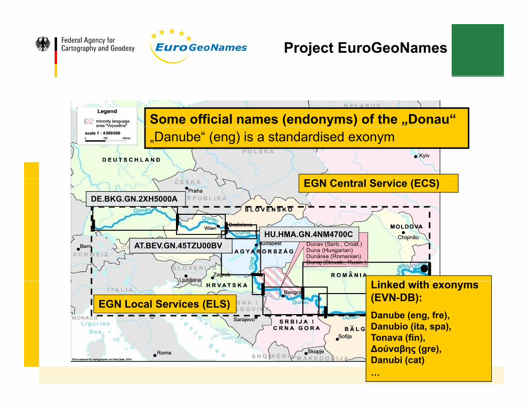
Some official names (endonyms) of the „Donau“ „Danube“ (eng) is a standardised exonym
EGN Central Service (ECS)DE.BKG.GN.2XH5000A
AT.BEV.GN.45TZU00BV HU.HMA.GN.4NM4700C
Li k d ith
EGN Local Services (ELS)
Linked with exonyms (EVN-DB):Danube (eng, fre), Danubio (ita, spa), Tonava (fin),Δούναβης (gre),Danubi (cat)…

INSPIRE
INSPIRE Thematic Working Group on Geographical Names TWG GNNames, TWG-GN
Goal:To develop an Implementing Rule for the theme “Geographical Names”To develop an Implementing Rule for the theme Geographical Names according to Directive 2007/2/EC of 14 March 2007 (INSPIRE –INfrastructure for SPatial InfoRmation in Europe). Published since 14 December 2009Published since 14 December 2009.
The project consortium of EuroGeoNames (EGN) submitted material to the INSPIRE initiative:- D4.2 – Conceptual schema & documentation (→ gazetteer profile)- D2.1 – Final Report on user/business requirements (→ use cases)- D3.3 – Metadata profilep- EGN feature classification
INSPIRE
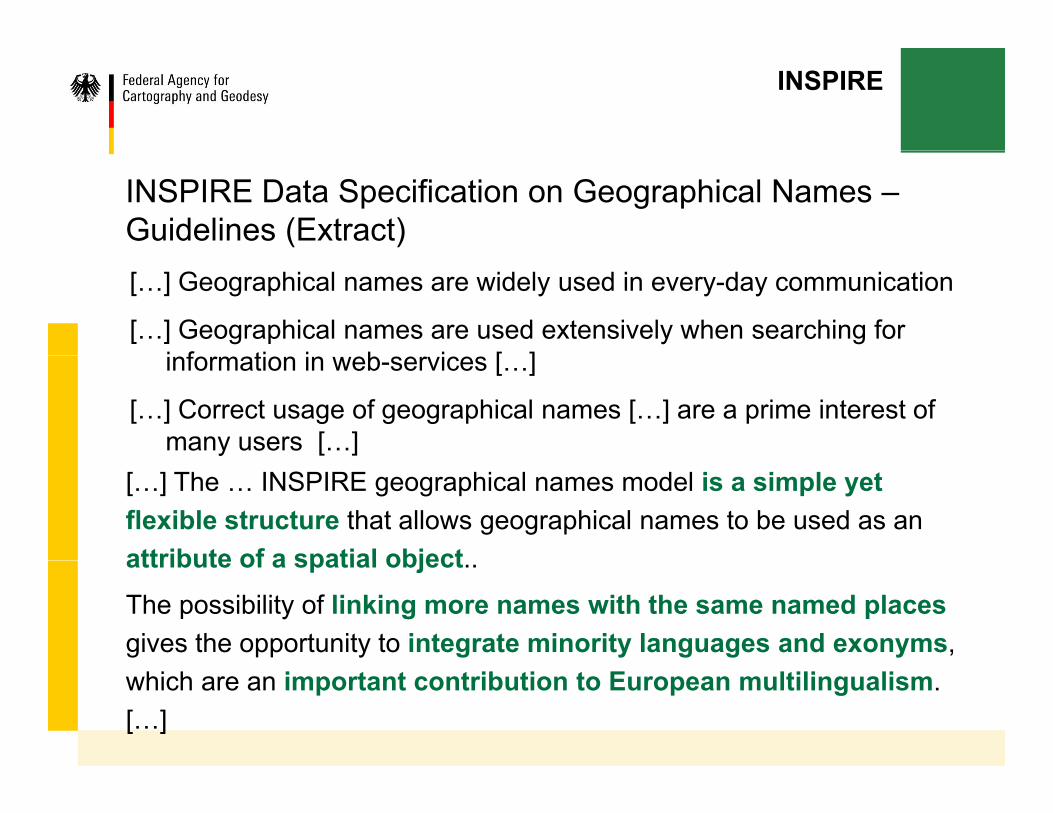
INSPIRE Data Specification on Geographical Names –Guidelines (Extract)[…] Geographical names are widely used in every-day communication
[…] Geographical names are used extensively when searching for i f ti i b i [ ]information in web-services […]
[…] Correct usage of geographical names […] are a prime interest of many users […]
[…] The … INSPIRE geographical names model is a simple yet flexible structure that allows geographical names to be used as an attribute of a spatial objectattribute of a spatial object..
The possibility of linking more names with the same named placesgives the opportunity to integrate minority languages and exonyms, which are an important contribution to European multilingualism. […]
INSPIRE
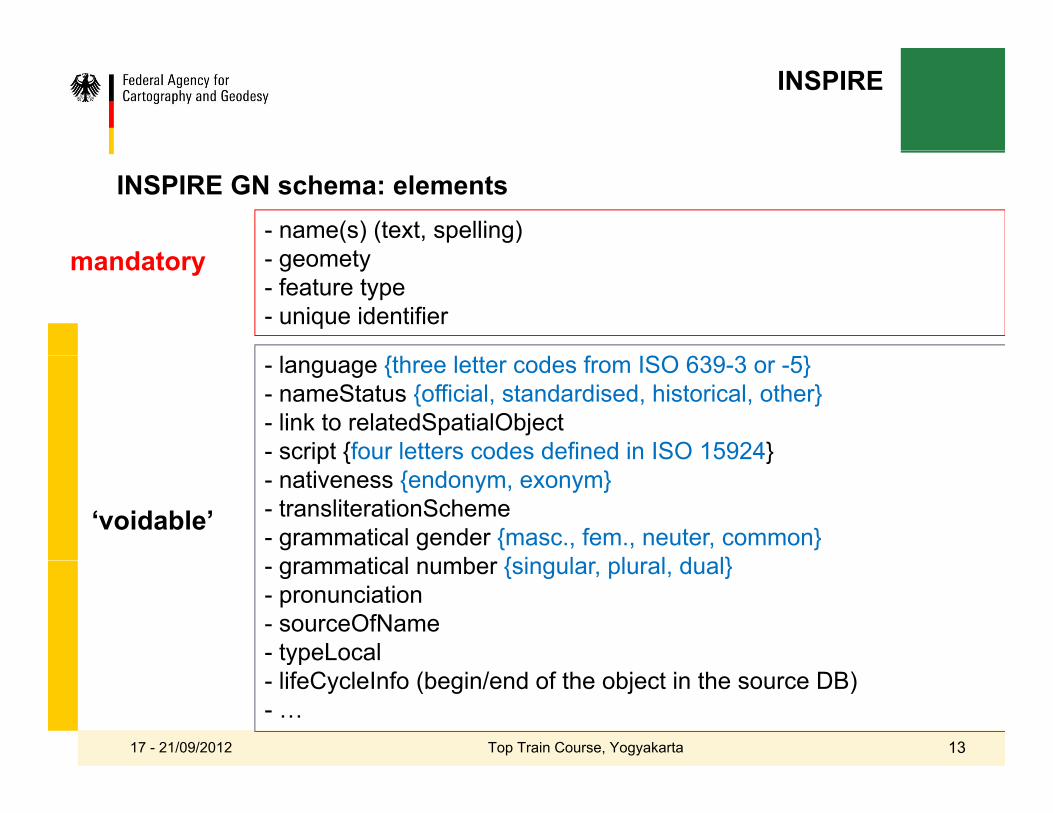
d t- name(s) (text, spelling)
t
INSPIRE GN schema: elements
{ f SO }
mandatory - geomety- feature type- unique identifier
- language {three letter codes from ISO 639-3 or -5} - nameStatus {official, standardised, historical, other}- link to relatedSpatialObject- script {four letters codes defined in ISO 15924}script {four letters codes defined in ISO 15924}- nativeness {endonym, exonym}- transliterationScheme- grammatical gender {masc., fem., neuter, common}
ti l b { i l l l d l}
‘voidable’ - grammatical number {singular, plural, dual} - pronunciation- sourceOfName - typeLocalyp- lifeCycleInfo (begin/end of the object in the source DB)- …
17 - 21/09/2012 13Top Train Course, Yogyakarta

INSPIRE
INSPIRE GN Schema (UML)Geographical Names model v3.1
17 - 21/09/2012 14Top Train Course, Yogyakarta
Geonames.org – application & services
www.Geonames.org
Goal:Goal:Aggregate free geographical names data from various sources and make it available as a database or via a range of web services.
Content:- GeoNames includes over 8.5 million toponyms for 6.5 million places with
2 million alternate names in up to 200 languages.
- The information covers coordinates, administrative divisions, postal codes, , , p ,population, elevation, timezone amongst others.
- Geonames aggregates data from NMCAs (no European!), national statistical offices national postal services as well as the US Army (GNS Server =offices, national postal services as well as the US Army (GNS Server = main source), Wikipedia and gtopo30 (elevation data).

Geonames.org – application & services
www.Geonames.org
Slide 16

Geonames.org – application & services
www.Geonames.org
Slide 17

UNGEGN database - application
http://unstats.un.org/unsd/geoinfo/geonames/Default.aspx

UNGEGN database - application

UNGEGN database - application
UNECA initiative –GeoNyms desktop application
Objectives:
y p pp
Objectives:
▪ Provide African countries a free tool (based on open source software))
▪ Make up African SDI->UNGEGN Geographical Names DB
Background:
▪ Ethiopian mapping authority was using an MS Excel formEthiopian mapping authority was using an MS Excel form for collecting geographic names.
▪ Came to UNECA-Geoinfo for a better solutionCame to UNECA Geoinfo for a better solution
▪ web based intranet solution 17 - 21/09/2012 21Top Train Course, Yogyakarta
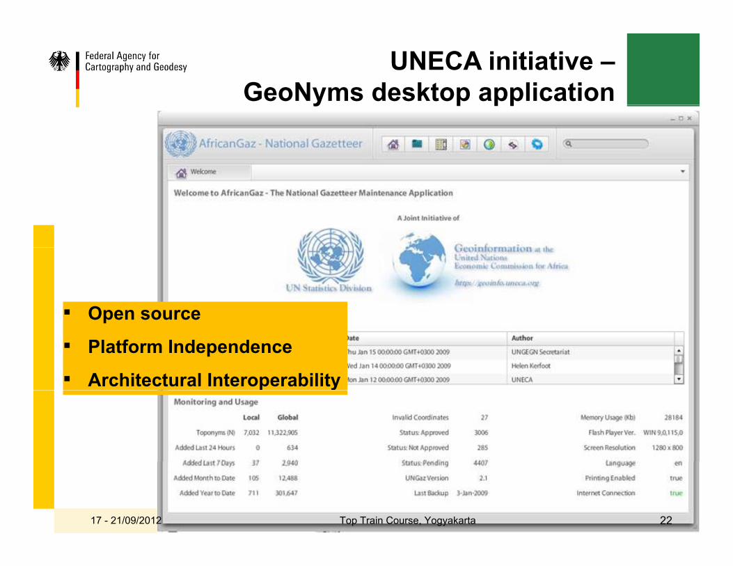
UNECA initiative –GeoNyms desktop applicationy p pp
▪ Open sourceOpen source
▪ Platform Independence
▪ Architectural Interoperability
17 - 21/09/2012 22Top Train Course, Yogyakarta

UNECA initiative –GeoNyms desktop applicationy p pp
Architectural compatibility…
▪ with African SDI names databasewith African SDI names database
▪ with new items , application settings -> based on requirements of the Member Statesq
▪ with geographical Name records (Feature Data) -> Global DB.
17 - 21/09/2012 23Top Train Course, Yogyakarta

UNECA initiative –GeoNyms desktop applicationy p pp
17 - 21/09/2012 24Top Train Course, Yogyakarta

UNECA initiative –GeoNyms desktop applicationy p pp
17 - 21/09/2012 25Top Train Course, Yogyakarta

UNECA initiative –GeoNyms desktop applicationy p pp
17 - 21/09/2012 26Top Train Course, Yogyakarta

UNECA initiative –GeoNyms desktop applicationy p pp
17 - 21/09/2012 27Top Train Course, Yogyakarta

UNECA initiative –GeoNyms desktop application
Benefits of the UNECA software:
y p pp
Benefits of the UNECA software:
▪ Complete Development
C d t k h M th d l d t l▪ Conduct workshops on Methodology and tool
▪ Support and encourage member states to populate DB
▪ Integrate African Toponyms/ African SDI ->UNGEGN DB
▪ Develop African toponyms website
▪ Assist African countries to develop/host their own toponym website/DBs
▪ Promote/ensure the usage of these DBs 17 - 21/09/2012 28Top Train Course, Yogyakarta