Oct 2015 Preliminary Alternatives Newsletter Traffic Congestion Management

PRELIMINARY – SUBJECT TO CHANGEPRELIMINARY ADMINISTRATIVE DRAFT DECEMBER 2013 2-1 NORTH-OF-THE- DELTA OFFSTREAM STORAGE PROJECT EIR/EISWBG020812033556SAC/433094 (02-ALTERNATIVES_ANALYSIS_PRELIM_ADMIN_DRAFT_DEC2013.DOCX)
2. Alternatives Analysis
2.1 Introduction
CEQA Guidelines Section 15126.6 requires that an EIR describe and evaluate a reasonable range of
alternatives that would feasibly meet most of the basic project objectives but would avoid or substantially
lessen significant Project impacts. CEQA also requires that an EIR evaluate the “No Project” alternative
along with its impacts. An EIR need only examine in detail alternatives that the lead agency determines
could feasibly attain most of the objectives of the project and would avoid or substantially lessen at least
one of the significant environmental effects of the project.
The National Environmental Policy Act’s (NEPA’s) implementing regulations are administered by the
Council on Environmental Quality (CEQ) (40 CFR 1500 et seq.). Section 1502.14 of the CEQ
Regulations for Implementing NEPA requires that an EIS rigorously explore and objectively evaluate all
reasonable alternatives to the project, including a No Action Alternative and reasonable alternatives not
within the jurisdiction of the lead agency. Additionally, NEPA requires that an EIS devote substantial
treatment to each alternative considered in detail, including the proposed action, so that reviewers may
evaluate their comparative merits.
This chapter summarizes the alternatives development process and alternatives analysis for the NODOS
Project. A more detailed description of this comprehensive and iterative process is included in the
NODOS Project Feasibility Report.
The proposed Project is defined as north-of-the-Delta offstream storage that should achieve, as much as
possible, the following objectives: 1) Improve water supply reliability for agricultural, urban, and
environmental uses, 2) Increase survival of anadromous and endemic fish populations, 3) Improve
environmental and drinking water quality in the Delta, 4) Provide flexible hydropower generation to
support integration of renewable energy sources, 5) Develop additional recreation opportunities, and
6) Provide incremental flood damage reduction opportunities.
2.2 Approach to Alternatives Analysis
2.2.1 Overview of the Alternatives Analysis
The NODOS Project alternatives analysis was completed in phases. The study of the NODOS Project was
originally derived from the CALFED Bay-Delta Program’s (CALFED Program) identification of a range
of activities that, if implemented, could concurrently improve the quality and reliability of California’s
water supplies as well as ecosystem conditions and levee integrity in the Sacramento-San Joaquin Delta.
Among many recommended activities, the CALFED Program identified the need for an additional 3.0-
MAF of storage north of the Delta to meet environmental and water supply needs. The CALFED Program
also expressed a preference for offstream over onstream storage to avoid redirected impacts to fisheries
and other aquatic species. The CALFED Program initially identified 52 potential surface storage
locations1 but retained only 12 reservoir locations statewide for further study (CALFED, 2000). For a
1The results of this inventory are presented in the March 7, 1997 draft report, CALFED Bay-Delta Program Storage andConveyance Component Inventories (CALFED, 1997). The inventory includes 51 potential surface water storage sites.Subsequently, the August 2000 CALFED Initial Surface Water Storage Screening Report added the San Luis Enlargement to the listof potential sites.
This document is not released as a draft EIR pursuant to CEQA Guidelines § 15087. As such, DWR is not soliciting and will not respond to commentssubmitted on this document, although any comments received will be retained and may be considered during preparation of a future draft EIR.

Chapter 2: Alternatives Analysis
PRELIMINARY – SUBJECT TO CHANGENORTH-OF-THE- DELTA OFFSTREAM STORAGE PROJECT EIR/EIS 2-2 PRELIMINARY ADMINISTRATIVE DRAFT DECEMBER 2013
WBG020812033556SAC/433094 (02-ALTERNATIVES_ANALYSIS_PRELIM_ADMIN_DRAFT_DEC2013.DOCX)
summary of the CALFED Program Inventory of Potential Surface Water Storage Sites, refer to
Appendix 2A. Red Bank, Newville, Colusa, and Sites are four (of the 12) reservoir locations that are
offstream and located north of the Delta. Consistent with these recommendations, DWR initiated studies
of the four north-of-the-Delta offstream storage alternatives in 1997.
The consideration and evaluation of these four alternatives is described below. DWR and Reclamation
eliminated the Red Bank and Colusa alternatives based upon a comparison of environmental effects and
feasibility considerations, which are documented in the 2000 NODOS Investigation Progress Report and
in the 2006 NODOS Initial Alternatives Information Report. This allowed DWR and Reclamation to
compare and evaluate the No Project/No Action Alternative, the Newville Reservoir Alternative, and the
Sites Reservoir Alternative in greater detail, consistent with NEPA and CEQA requirements. Based on the
detailed evaluation of these alternatives, the Sites Reservoir Alternative was selected as the preferred
proposed project alternative.
DWR and Reclamation have also completed a more detailed evaluation of effects, consistent with CEQA
and NEPA requirements, of three configurations of Sites Reservoir, hereafter called Alternative A,
Alternative B, and Alternative C. The results and conclusions of these evaluations are found in Chapters 6
through 35. For purposes of CEQA, these alternatives should be considered as three variations of the Sites
Reservoir Alternative (i.e. the preferred Project alternative). For NEPA purposes, Alternative A,
Alternative B, Alternative C, and the No Project/No Action Alternative were evaluated in detail in
accordance with the Council on Environmental Quality regulation 1502.14b.
2.2.2 Alternatives Considered
The four north-of-the-Delta offstream storage reservoir alternatives are described below and are shown on
Figure 2-1:
Red Bank Alternative: The Red Bank Alternative would be located approximately 17 miles west of
the City of Red Bluff in Tehama County. This project would be comprised of a 104-TAF Dippingvat
Reservoir on South Fork Cottonwood Creek, and a 250-TAF Schoenfield Reservoir on Red Bank
Creek. The primary source of water would be from South Fork Cottonwood Creek, with water
diverted from Dippingvat Reservoir to Schoenfield Reservoir. Two small dams and reservoirs,
Lanyan and Bluedoor, would be located on small tributaries of Red Bank Creek and would be part of
the conveyance from Dippingvat to Schoenfield. Dippingvat Reservoir would be an onstream storage
facility used for short-term storage and diversion; Schoenfield is considered to be an offstream
storage facility. This alternative location was designed to allow water stored in Schoenfield Reservoir
to be released down Red Bank Creek directly into the Tehama-Colusa Canal intake. The Red Bank
Alternative was conceived to provide an alternative water supply to the Tehama-Colusa Canal which
would not require operation of the Red Bluff Diversion Dam (RBDD) during critical fish passage
periods (estimated to be approximately two months per year).
Newville Reservoir Alternative: The Newville Reservoir Alternative would be located upstream
from Black Butte Reservoir, approximately 18 miles west of the City of Orland and 23 miles west-
southwest of the City of Corning in Glenn and Tehama counties. Alternative reservoir sizes of 1.9-
MAF and 3.0-MAF were considered. The 1.9-MAF reservoir would be formed by a dam on North
Fork Stony Creek and a saddle dam at Burrows Gap. The 3.0-MAF reservoir would require up to five
additional saddle dams and a dike. A small diversion dam and diversion from Thomes Creek would
transfer water to the reservoir. Other water source options include Stony Creek and the Sacramento
This document is not released as a draft EIR pursuant to CEQA Guidelines § 15087. As such, DWR is not soliciting and will not respond to commentssubmitted on this document, although any comments received will be retained and may be considered during preparation of a future draft EIR.
Chapter 2: Alternatives Analysis
PRELIMINARY – SUBJECT TO CHANGEPRELIMINARY ADMINISTRATIVE DRAFT DECEMBER 2013 2-3 NORTH-OF-THE- DELTA OFFSTREAM STORAGE PROJECT EIR/EISWBG020812033556SAC/433094 (02-ALTERNATIVES_ANALYSIS_PRELIM_ADMIN_DRAFT_DEC2013.DOCX)
River. Multiple conveyance options would be possible using existing infrastructure (e.g., canals), new
infrastructure (e.g., canals, tunnels, and/or pipelines), or a combination of new and existing facilities.
Sites Reservoir Alternative: The Sites Reservoir Alternative, which would be located in Antelope
Valley, approximately 10 miles west of the town of Maxwell in Glenn and Colusa counties, would be
formed by constructing two major dams on Stone Corral Creek and Funks Creek. Evaluation of the
Sites Reservoir Alternative focused on a 1.8-MAF reservoir that would also require the construction
of nine saddle dams along the southern edge of the Hunters Creek watershed. Diversions from the
Colusa Basin Drain (CBD), the Sacramento River, and local tributaries could provide potential
sources of water supply for Sites Reservoir. Multiple conveyance options would be possible, with
13 optional conveyance systems (using existing and new conveyance infrastructure) from the
Sacramento River, two from CBD, and two from Stony Creek.
Colusa Reservoir Alternative: The Colusa Reservoir Alternative would be located in north-central
Colusa County and south-central Glenn County, approximately 12 miles southwest of the community
of Willows and 10 miles west of Maxwell. The Colusa Reservoir Alternative, a 3.0-MAF storage
project, would include the area inundated by the 1.8-MAF Sites Reservoir (described above) plus the
adjacent Logan Creek and Hunters Creek watersheds to the north (known as the Colusa Cell). The
Colusa Cell would require four major dams along Logan Ridge in addition to those described for
Sites Reservoir: one for Logan Creek and three for Hunters Creek and its tributaries. The Colusa Cell
would add up to 67 percent greater storage capacity to Sites Reservoir. Water source and conveyance
options for diversion and delivery to offstream storage would be similar to those for Sites Reservoir.
Diversions from the Colusa Basin Drain (CBD), the Sacramento River, and local tributaries would
provide potential sources of water supply for the Colusa Reservoir Alternative. Multiple conveyance
options would be possible using existing infrastructure (e.g., canals), new infrastructure (e.g., canals,
tunnels, and/or pipelines), or a combination of new and existing infrastructure.
Previous studies, going back as far as the 1940s, were conducted at each of the four reservoir alternative
locations. Data gathered during the NODOS Investigation was used to supplement those studies to allow
for comparative evaluation of the alternatives. During the NODOS Investigation, geology, geotechnical,
and engineering studies were conducted. Wetland delineations and cultural resources surveys were also
conducted, as well as studies of the following environmental resources: vernal pool species, rare plants,
plant communities, valley elderberry longhorn beetles, mammals, birds, fish, amphibians, and reptiles.
Studies were conducted at similar levels of effort for each reservoir alternative and focused primarily on
the reservoir footprints. The results of these studies were summarized in the July 2000 North of the Delta
Offstream Storage Investigation Progress Report (DWR 2000). Environmental resources data collected
for the four reservoir alternatives for the 2000 Progress Report are summarized in Tables 2-1 through 2-9.
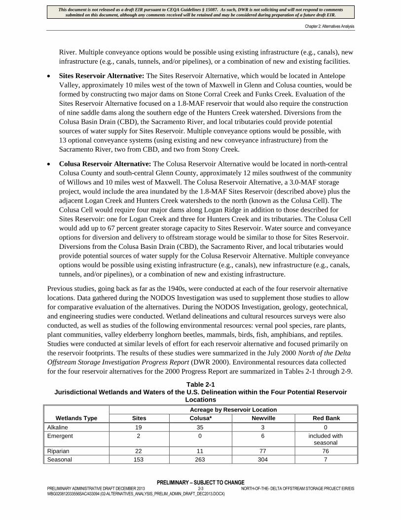
Table 2-1Jurisdictional Wetlands and Waters of the U.S. Delineation within the Four Potential Reservoir
Locations
Wetlands Type
Acreage by Reservoir Location
Sites Colusa* Newville Red Bank
Alkaline 19 35 3 0
Emergent 2 0 6 included withseasonal
Riparian 22 11 77 76
Seasonal 153 263 304 7
This document is not released as a draft EIR pursuant to CEQA Guidelines § 15087. As such, DWR is not soliciting and will not respond to commentssubmitted on this document, although any comments received will be retained and may be considered during preparation of a future draft EIR.
Chapter 2: Alternatives Analysis
PRELIMINARY – SUBJECT TO CHANGENORTH-OF-THE- DELTA OFFSTREAM STORAGE PROJECT EIR/EIS 2-4 PRELIMINARY ADMINISTRATIVE DRAFT DECEMBER 2013
WBG020812033556SAC/433094 (02-ALTERNATIVES_ANALYSIS_PRELIM_ADMIN_DRAFT_DEC2013.DOCX)
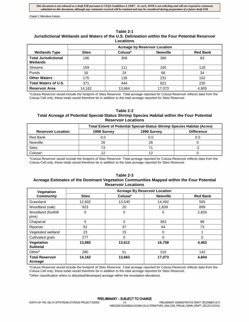
Table 2-1Jurisdictional Wetlands and Waters of the U.S. Delineation within the Four Potential Reservoir
Locations
Wetlands Type
Acreage by Reservoir Location
Sites Colusa* Newville Red Bank
Total JurisdictionalWetlands
196 309 390 83
Streams 159 111 165 118
Ponds 16 24 66 34
Other Waters 175 135 231 152
Total Waters of U.S. 371 444 621 235
Reservoir Area 14,162 13,664 17,073 4,905
*Colusa Reservoir would include the footprint of Sites Reservoir. Total acreage reported for Colusa Reservoir reflects data from theColusa Cell only; these totals would therefore be in addition to the total acreage reported for Sites Reservoir.
Table 2-2Total Acreage of Potential Special-Status Shrimp Species Habitat within the Four Potential
Reservoir Locations
Reservoir Location
Total Extent of Potential Special-Status Shrimp Species Habitat (Acres)
1998 Survey 1999 Survey Difference
Red Bank 0.0 0.0 0.0
Newville 26 26 0
Sites 73 71 -2
Colusa* 12 12 0
*Colusa Reservoir would include the footprint of Sites Reservoir. Total acreage reported for Colusa Reservoir reflects data from theColusa Cell only; these totals would therefore be in addition to the total acreage reported for Sites Reservoir.
Table 2-3Acreage Estimates of the Dominant Vegetation Communities Mapped within the Four Potential
Reservoir Locations
VegetationCommunity
Acreage By Reservoir Location
Sites Colusaa Newville Red Bank
Grassland 12,602 13,540 14,492 565
Woodland (oak) 923 20 1,839 899
Woodland (foothillpine)
0 0 0 2,826
Chaparral 5 0 363 98
Riparian 52 37 64 73
Vegetated wetland 23 15 0 1
Cultivated grain 277 0 0 0
VegetationSubtotal
13,882 13,612 16,758 4,462
Otherb 280 51 315 142
Total ReservoirAcreage
14,162 13,663 17,073 4,604
aColusa Reservoir would include the footprint of Sites Reservoir. Total acreage reported for Colusa Reservoir reflects data from theColusa Cell only; these totals would therefore be in addition to the total acreage reported for Sites Reservoir.bOther classification refers to disturbed/developed acreage within the inundation elevations.
This document is not released as a draft EIR pursuant to CEQA Guidelines § 15087. As such, DWR is not soliciting and will not respond to commentssubmitted on this document, although any comments received will be retained and may be considered during preparation of a future draft EIR.

Chapter 2: Alternatives Analysis
PRELIMINARY – SUBJECT TO CHANGEPRELIMINARY ADMINISTRATIVE DRAFT DECEMBER 2013 2-5 NORTH-OF-THE- DELTA OFFSTREAM STORAGE PROJECT EIR/EISWBG020812033556SAC/433094 (02-ALTERNATIVES_ANALYSIS_PRELIM_ADMIN_DRAFT_DEC2013.DOCX)
Table 2-4State-Listed, Federally-Listed, and Special Concern Avian Species
Which May Occur at the Four Potential Reservoir Locations
Species Statusa
Reservoir Location
Sites Colusab Newville Red Bank
Aleutian Canada Goose FT
American bittern MNBMC
American white pelican CSSC
Bank swallow ST X
Barrow’s goldeneye CSSC
Bell’s sage sparrow MNBMC
Burrowing owl CSSC, MNBMC X X X
California gull CSSC X
California horned lark CSSC, MNBMC X X X X
Common loon CSSC, MNBMC
Cooper’s hawk CSSC X X X X
Double-crestedcormorant
CSSC X
Ferruginous hawk CSSC, MNBMC X
Golden eagle CSSC X X X X
Grasshopper sparrow MNBMC X
Greater sandhill crane ST X
Hermit warbler MNBMC
Lark sparrow MNBMC X X X X
Lawrence’s goldfinch MNBMC X X
Least bittern MNBMC
Loggerhead shrike CSSC, MNBMC X X X X
Long-billed curlew CSSC, MNBMC X X X
Long-eared owl CSSC X X X X
Merlin CSSC X X X
Mountain plover CSSC, MNBMC
Northern goshawk CSSC, MNBMC
Northern harrier CSSC X X X X
Northern spotted owl FE, SE
Osprey CSSC X
Peregrine falcon SE
Prairie falcon CSSC X X X X
Purple martin CSSC
Sharp-shinned hawk CSSC X X X
Short-eared owl CSSC, MNBMC
Southern bald eagle SE, FT X X X X
Swainson’s hawk ST
Tri-colored blackbird CSSC, MNBMC X X X
This document is not released as a draft EIR pursuant to CEQA Guidelines § 15087. As such, DWR is not soliciting and will not respond to commentssubmitted on this document, although any comments received will be retained and may be considered during preparation of a future draft EIR.

Chapter 2: Alternatives Analysis
PRELIMINARY – SUBJECT TO CHANGENORTH-OF-THE- DELTA OFFSTREAM STORAGE PROJECT EIR/EIS 2-6 PRELIMINARY ADMINISTRATIVE DRAFT DECEMBER 2013
WBG020812033556SAC/433094 (02-ALTERNATIVES_ANALYSIS_PRELIM_ADMIN_DRAFT_DEC2013.DOCX)
Table 2-4State-Listed, Federally-Listed, and Special Concern Avian Species
Which May Occur at the Four Potential Reservoir Locations
Species Statusa
Reservoir Location
Sites Colusab Newville Red Bank
Vaux’s swift CSSC, MNBMC
Western snowy plover CSSC, MNBMC
Western yellow-billedcuckoo
SE, MNBMC
White-faced ibis CSSC, MNBMC
White-faced kite MNBMC X
Willow flycatcher SE
Yellow warbler CSSC X
Yellow-breasted chat CSSC
aListing status as of 2000 when initial surveys were completed.bColusa Reservoir would include the footprint of Sites Reservoir. Avian species reported for Colusa Reservoir reflect data from theColusa Cell only; the total number of avian species that could occur within the Colusa Reservoir location would therefore be inaddition to the species that could occur within the Sites Reservoir location.
Key:
CSSC = California Species of Special ConcernFE = Federal EndangeredFT = Federal ThreatenedFPT = Federal Proposed ThreatenedMNBMC = Migratory Nongame Birds of Management Concern (USFWS)SE = State EndangeredST = State ThreatenedX = Observed at reservoir site indicated
Table 2-5Sites Reservoir Avian Transect Results
(Density in Birds/Square Mile)
Species Summer Fall Winter Spring
Burrowing owl 0.24 0.05
California horned lark 4.83 1.58 2.90 6.57
Cooper’s hawk 0.03 0.06
Ferruginous hawk 0.12
Golden eagle 0.23 0.20 0.26 0.32
Lark sparrow NS NS 0.47 1.46
Loggerhead shrike 0.93 1.60 1.17 0.47
Long-billed curlew 14.59 1.26
Northern harrier 0.05 0.50 1.53 0.58
Sharp-shinned hawk 0.40 0.03
Southern bald eagle 0.07
Tri-colored blackbird 5.38
White-tailed kite 0.12 0.12
Miles of transect per season 37.5 88.0 75.0 150.5
Note:
NS = Not Sampled
This document is not released as a draft EIR pursuant to CEQA Guidelines § 15087. As such, DWR is not soliciting and will not respond to commentssubmitted on this document, although any comments received will be retained and may be considered during preparation of a future draft EIR.
Chapter 2: Alternatives Analysis
PRELIMINARY – SUBJECT TO CHANGEPRELIMINARY ADMINISTRATIVE DRAFT DECEMBER 2013 2-7 NORTH-OF-THE- DELTA OFFSTREAM STORAGE PROJECT EIR/EISWBG020812033556SAC/433094 (02-ALTERNATIVES_ANALYSIS_PRELIM_ADMIN_DRAFT_DEC2013.DOCX)
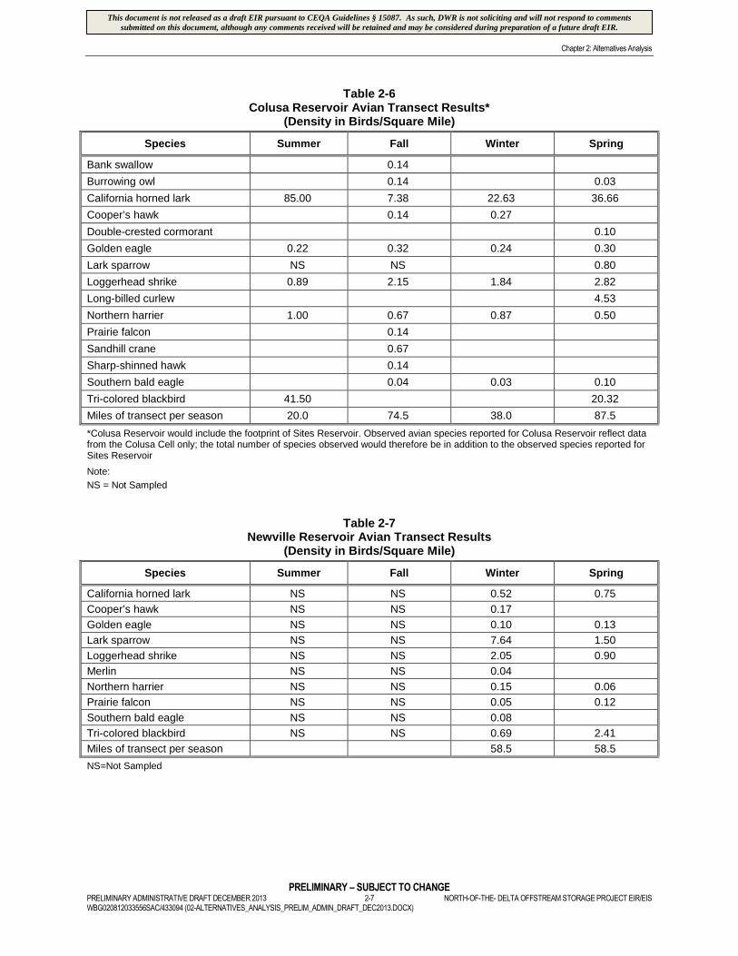
Table 2-6Colusa Reservoir Avian Transect Results*
(Density in Birds/Square Mile)
Species Summer Fall Winter Spring
Bank swallow 0.14
Burrowing owl 0.14 0.03
California horned lark 85.00 7.38 22.63 36.66
Cooper’s hawk 0.14 0.27
Double-crested cormorant 0.10
Golden eagle 0.22 0.32 0.24 0.30
Lark sparrow NS NS 0.80
Loggerhead shrike 0.89 2.15 1.84 2.82
Long-billed curlew 4.53
Northern harrier 1.00 0.67 0.87 0.50
Prairie falcon 0.14
Sandhill crane 0.67
Sharp-shinned hawk 0.14
Southern bald eagle 0.04 0.03 0.10
Tri-colored blackbird 41.50 20.32
Miles of transect per season 20.0 74.5 38.0 87.5
*Colusa Reservoir would include the footprint of Sites Reservoir. Observed avian species reported for Colusa Reservoir reflect datafrom the Colusa Cell only; the total number of species observed would therefore be in addition to the observed species reported forSites Reservoir
Note:
NS = Not Sampled
Table 2-7Newville Reservoir Avian Transect Results
(Density in Birds/Square Mile)
Species Summer Fall Winter Spring
California horned lark NS NS 0.52 0.75
Cooper’s hawk NS NS 0.17
Golden eagle NS NS 0.10 0.13
Lark sparrow NS NS 7.64 1.50
Loggerhead shrike NS NS 2.05 0.90
Merlin NS NS 0.04
Northern harrier NS NS 0.15 0.06
Prairie falcon NS NS 0.05 0.12
Southern bald eagle NS NS 0.08
Tri-colored blackbird NS NS 0.69 2.41
Miles of transect per season 58.5 58.5
NS=Not Sampled
This document is not released as a draft EIR pursuant to CEQA Guidelines § 15087. As such, DWR is not soliciting and will not respond to commentssubmitted on this document, although any comments received will be retained and may be considered during preparation of a future draft EIR.

Chapter 2: Alternatives Analysis
PRELIMINARY – SUBJECT TO CHANGENORTH-OF-THE- DELTA OFFSTREAM STORAGE PROJECT EIR/EIS 2-8 PRELIMINARY ADMINISTRATIVE DRAFT DECEMBER 2013
WBG020812033556SAC/433094 (02-ALTERNATIVES_ANALYSIS_PRELIM_ADMIN_DRAFT_DEC2013.DOCX)
Table 2-8Red Bank Project Avian Transect Results
(Density in Birds/Square Mile)
Species Summer Fall Winter Spring
Cooper’s hawk 0.07 0.16 0.26
Garden eagle 0.09 0.25 0.30 0.32
Lark sparrow NS NS 0.18 4.79
Lawrence’s goldfinch 0.36 0.78
Merlin 0.07
Northern harrier 0.08 1.07 0.26
Osprey 0.13
Prairie falcon 0.0 0.13
Sharp-shinned hawk 0.19 0.40 0.06
Southern bald eagle 0.11 0.05 0.26
Miles of transect per season 25.5 53.0 55.0 68.0
NS = Not Sampled
Table 2-9Sensitive Mammals Observed within the Four Potential Reservoir Locations
Species Sites Colusa* Newville RedBank
American badger X X X
Pallid bat X X X X
Ringtail X X
San Joaquin pocket mouse X
Western red bat X X
Yuma myotis X X X
*Colusa Reservoir would include the footprint of Sites Reservoir. Observed mammal species reported for Colusa Reservoir reflectdata from the Colusa Cell only; the total number of species observed would therefore be in addition to the observed speciesreported for Sites Reservoir.
2.2.3 Alternatives Considered but Rejected from Further Consideration
Following an evaluation of the results of the NODOS Investigation Progress Report (DWR, 2000), the
Red Bank and Colusa alternatives were eliminated from further consideration. The reasons for eliminating
these two alternatives are provided below.
2.2.3.1 Red Bank Alternative
The following issues contributed to the decision to eliminate the Red Bank Alternative from further
consideration:
Because the primary storage for the Red Bank Alternative (Schoenfield Reservoir) would be
offstream, the Red Bank Alternative was initially retained. However, the supply source (Dippingvat
Reservoir) would be onstream, which would result in greater environmental impacts and
implementation challenges. If Dippingvat Reservoir was removed from the alternative, another water
supply source would be needed to fill Schoenfield Reservoir, and the storage volume of the Red Bank
Alternative would be reduced to 0.25-MAF. This reduced storage volume would reduce the
alternative’s ability to provide broad benefits (when compared to the other location alternatives
considered). In addition to the small storage capacity, initial geotechnical investigations indicated the
potential for excessive reservoir leakage.
This document is not released as a draft EIR pursuant to CEQA Guidelines § 15087. As such, DWR is not soliciting and will not respond to commentssubmitted on this document, although any comments received will be retained and may be considered during preparation of a future draft EIR.

Chapter 2: Alternatives Analysis
PRELIMINARY – SUBJECT TO CHANGEPRELIMINARY ADMINISTRATIVE DRAFT DECEMBER 2013 2-9 NORTH-OF-THE- DELTA OFFSTREAM STORAGE PROJECT EIR/EISWBG020812033556SAC/433094 (02-ALTERNATIVES_ANALYSIS_PRELIM_ADMIN_DRAFT_DEC2013.DOCX)
The Red Bank Alternative location has greater habitat diversity than the other locations considered. More
than 60 percent of the Red Bank Alternative location consists of blue oak-foothill pine habitat and
approximately 20 percent consists of blue oak woodland habitat. In comparison, approximately 99, 85,
and 89 percent of the Colusa, Newville, and Sites reservoir alternative locations, respectively, are
dominated by annual grassland habitat. Consequently, the Red Bank Alternative site is able to support
numerous wildlife species, and supports a relatively high winter deer use compared to the other locations.
Cottonwood Creek is the largest undammed tributary in the upper Sacramento River Basin and is the
most important source of sediments to the Sacramento River. These sediments are necessary for river
meander, riparian recruitment, and spawning habitat. The Red Bank Alternative would substantially
reduce sediment contributions to the Sacramento River.
The South Fork of Cottonwood Creek also provides spawning habitat for fall-run and late-fall-run
Chinook salmon, and supports spring-run Chinook salmon in some years. In addition to these
potential fishery impacts, the California red-legged frog, federally listed as threatened, was observed
during field surveys. As evaluated, this alternative would result in significant and unavoidable
adverse effects to spring-run Chinook salmon and steelhead on the South Fork Cottonwood Creek.
Because of the potential for greater environmental impacts, the Red Bank Alternative was not
recommended for further consideration. In addition, the conceptual purpose of the Red Bank Alternative
was to supply the Corning and T-C canals early in the irrigation season, which would allow the RBDD
gates to be raised an additional month or more. Subsequent to the elimination of the Red Bank Alternative
from further consideration, NMFS released a Biological Opinion (2000) that requires phasing out the use
of the RBDD gates. Construction of the Red Bluff Diversion Dam Fish Passage Improvement Project,
which allows the RBDD gates to remain open permanently, was completed in September 2012. This new
infrastructure and required operational change makes the proposed Red Bank Alternative obsolete.
2.2.3.2 Colusa Reservoir Alternative
The following issues contributed to the decision to eliminate the Colusa Reservoir Alternative from
further consideration:
The Colusa Reservoir Alternative surface area (28,000 acres) would be two times larger than the
surface area of the Sites Reservoir Alternative (14,000 acres). Colusa’s larger reservoir footprint
(1.9 times the 1.9-MAF (14,500 acres) and 1.6 times the 3.0-MAF (7,000 acres) Newville Reservoir
options), and its larger facilities would have an overall greater environmental impact than the other
smaller reservoir alternatives.
The potential reservoir size of the Colusa, Newville, and Sites alternatives were compared with respect
to their capital construction cost for reservoir storage, yield, and unit cost of storage per deliverable
Project yield. This comparison helped identify, on an annualized basis, the relative cost-effectiveness of
each measure. The total capital storage cost (in 2004 dollars) for Sites Reservoir (1.8-MAF) was
estimated at $320,250,000; Colusa Reservoir (3.0-MAF) at $1,411,520,000; and Newville Reservoir
(1.9-MAF) at $235,134,000. Colusa Reservoir’s high total capital storage cost (4.4 to 6.0 times the cost
of the Newville and Sites reservoir alternatives respectively) made the Colusa Reservoir Alternative the
least cost effective alternative.
A preliminary economic assessment was conducted to compare the average annual cost of storage per
yield for the three reservoirs. The estimated average annual cost per yield would be similar in
This document is not released as a draft EIR pursuant to CEQA Guidelines § 15087. As such, DWR is not soliciting and will not respond to commentssubmitted on this document, although any comments received will be retained and may be considered during preparation of a future draft EIR.

Chapter 2: Alternatives Analysis
PRELIMINARY – SUBJECT TO CHANGENORTH-OF-THE- DELTA OFFSTREAM STORAGE PROJECT EIR/EIS 2-10 PRELIMINARY ADMINISTRATIVE DRAFT DECEMBER 2013
WBG020812033556SAC/433094 (02-ALTERNATIVES_ANALYSIS_PRELIM_ADMIN_DRAFT_DEC2013.DOCX)
magnitude for the Sites Reservoir Alternative ($64 per acre-feet) and the Newville Reservoir
Alternative ($47 per acre-feet), but would be comparatively excessive for the Colusa Reservoir
Alternative ($235 per acre-feet). The Sites Reservoir Alternative’s average annual cost for storage per
unit yield would be approximately 36 percent greater than the Newville Reservoir Alternative. The
Colusa Reservoir Alternative’s average annual cost for storage per unit yield would be approximately
367 percent greater than the Sites Reservoir Alternative and approximately 500 percent greater than
Newville Reservoir Alternative, while the increase in yield between the Colusa Reservoir Alternative
and the Sites and Newville reservoir alternatives would only be approximately 19 percent.
All of the environmental and cultural resources effects of the Colusa Reservoir Alternative would be
additive to those of the Sites Reservoir Alternative, as the Colusa Reservoir Alternative includes the entire
reservoir footprint of the Sites Reservoir Alternative. These potential environmental effects would include
substantial additional loss of wildlife habitat (13,664 acres) and impacts to wetlands and waters of the U.S.,
including an additional loss of 444 acres of waters of the U.S. above those identified for the 1.8 MAF Sites
Reservoir Alternative. All other environmental effects would be additive to those of the 1.8 MAF Sites
Reservoir Alternative. The Colusa Reservoir Alternative was determined to be infeasible due to cost, and
undesirable based on substantially greater environmental effects as compared to either the Sites or Newville
reservoir alternatives. Additionally, comparatively the Colusa Reservoir Alternative would fail to
substantially lessen any significant effects. Because of this comparative lack of efficiency and greater
environmental impact, the Colusa Reservoir Alternative was not recommended for further consideration.
2.3 Alternatives Selected for Analysis
The Sites and Newville reservoir alternatives were retained for further consideration. In addition, a No
Project Alternative and No Action Alternative were added for consideration.
2.3.1 Background
DWR and Reclamation retained both the Sites and Newville reservoir alternatives for further analysis, as
both alternatives were considered technically feasible and not enough data had been gathered to provide a
meaningful comparison between the two alternatives. The NODOS Investigation continued engineering,
geologic, environmental, and cultural resource data collection on the reservoir footprints. Additionally,
these evaluations were expanded to include other major project facilities including diversions,
conveyance routes, road relocations, recreation areas, and regulating reservoirs for both the Sites and
Newville reservoir alternatives. These data allowed a more complete and robust comparison of the
environmental effects of the two alternatives. DWR’s November 5, 2001 Notice of Preparation (NOP)
and Reclamation’s November 9, 2001 Notice of Intent (NOI) indicated that the No Project, No Action,
Sites Reservoir, and Newville Reservoir alternatives would be analyzed in the NODOS Project EIR/EIS.
Reclamation’s NOI also allowed for the evaluation of other alternatives to meet NODOS Project
objectives, including conjunctive use or Shasta Reservoir enlargement, either as stand-alone projects or in
conjunction with other NODOS Project alternatives.
Subsequent evaluations by other programs determined that the potential for conjunctive use is limited
because Sacramento Valley groundwater basins recharge annually, leaving no space for operable storage
(NHI and GCID 2011; URS 2007). Conjunctive use was, therefore, not retained as a feasible alternative.
Reclamation is investigating Shasta Lake enlargement as part of its Shasta Lake Water Resources
Investigation. State involvement in this project is effectively barred by Public Resources Code
This document is not released as a draft EIR pursuant to CEQA Guidelines § 15087. As such, DWR is not soliciting and will not respond to commentssubmitted on this document, although any comments received will be retained and may be considered during preparation of a future draft EIR.
Chapter 2: Alternatives Analysis
PRELIMINARY – SUBJECT TO CHANGEPRELIMINARY ADMINISTRATIVE DRAFT DECEMBER 2013 2-11 NORTH-OF-THE- DELTA OFFSTREAM STORAGE PROJECT EIR/EISWBG020812033556SAC/433094 (02-ALTERNATIVES_ANALYSIS_PRELIM_ADMIN_DRAFT_DEC2013.DOCX)
section 5093.542, which authorizes DWR to participate in studies involving the technical and economic
feasibility of enlargement of Shasta Dam but otherwise prohibits DWR or any State department or agency to
assist or cooperate with any other entity on a project “…that could have an adverse effect on the free-flowing
condition of the McCloud River, or on its wild trout fishery.” As a result, Shasta Lake enlargement was not
retained as a feasible alternative to meet NODOS Project objectives. Along with the No Project/No Action
alternative, the Sites and Newville reservoir alternatives were retained for further analysis.
The alternatives were evaluated based on their ability to meet the following NODOS Project primary and
secondary objectives (Table 2-10).
Table 2-10North-of-the-Delta Offstream Storage Project Primary and Secondary Planning Objectives*
Primary Objectives Secondary Objectives
Improve water supply reliability for agricultural, urban,and environmental uses.
Develop additional recreation opportunities in the studyarea
Improve environmental and drinking water quality in theDelta.
Provide incremental flood damage reductionopportunities
Increase survival of anadromous fish populations, aswell as the health and survivability of other aquaticspecies
Provide flexible hydropower generation to supportintegration of renewable energy sources
*Primary planning objectives are the first priority that Project alternatives must address; Secondary planning objectives areopportunities that should be considered, to the extent possible, while meeting the Primary objectives.
Source: DWR and Reclamation, 2008.
The alternatives retained for further analysis are described below.
2.3.2 No Project/No Action Alternative
Existing Conditions, the No Project Alternative, and the No Action Alternative are described below to explain
how the No Project/No Action Alternative was developed. The nature of the CEQA No Project Alternative
and NEPA No Action Alternative are discussed briefly and separately below, but because the alternatives are,
in this case, the same, all subsequent references will be to the No Project/No Action Alternative.
2.3.2.1 Existing Conditions
The CEQA Baseline for assessing significance of impacts of the proposed Project is the environmental
setting, or Existing Conditions, at the time a NOP is issued, as provided for in CEQA Guidelines section
15125. However, the CEQA lead agency has the discretion, where appropriate, to fully or partially update
baseline conditions beyond the time of the issuance of the NOP. The CEQA Baseline is developed to
assess the significance of impacts of the proposed Project in relation to the actual environment upon
which the proposed Project will operate. Generally, this environment is represented by conditions that
exist at the time the NOP is issued. However, if the preparation of the EIR occurs over many years, it may
be more relevant to expand the definition to include programs, projects, or policies that have been
implemented during the preparation of the EIR.
The NOP for the proposed Project was published on November 5, 2001. However, because the
preparation of this environmental document has occurred over many years, it was deemed necessary to
update the baseline condition to June 2009 to include programs, projects, or policies that have been
implemented during the document’s preparation. Changes in the regulatory environment since November
This document is not released as a draft EIR pursuant to CEQA Guidelines § 15087. As such, DWR is not soliciting and will not respond to commentssubmitted on this document, although any comments received will be retained and may be considered during preparation of a future draft EIR.

Chapter 2: Alternatives Analysis
PRELIMINARY – SUBJECT TO CHANGENORTH-OF-THE- DELTA OFFSTREAM STORAGE PROJECT EIR/EIS 2-12 PRELIMINARY ADMINISTRATIVE DRAFT DECEMBER 2013
WBG020812033556SAC/433094 (02-ALTERNATIVES_ANALYSIS_PRELIM_ADMIN_DRAFT_DEC2013.DOCX)
2001 have fundamentally changed water management in California and necessitate updating the baseline
conditions for environmental analyses in this DEIR/EIS. These changes include the issuance of new
biological opinions (BO) by the U. S. Fish and Wildlife Service (USFWS) in December 2008 and the
National Marine Fisheries Service (NMFS) in June 2009 on the operations of the State Water Project and
Central Valley Project. Consequently, June 2009 (following the release of NMFS’ BO) was selected as
the proposed Project’s Existing Conditions date.
2.3.2.2 No Project Alternative
CEQA requires an analysis of an alternative in which the proposed Project is not implemented. CEQA calls
this scenario the No Project Alternative. The No Project Alternative allows decision-makers to use the EIR
to compare the impacts of approving the proposed Project with the future conditions of not approving the
proposed Project. Under CEQA, the No Project Alternative is the baseline for assessing the significance of
impacts of the proposed Project (CEQA Guidelines section 15126.6 subsection (c) (1)). Analysis of the No
Project Alternative proceeds along different lines depending upon the nature of the project. Where, as here,
the project is a development project on identifiable property, the “no project” alternative is the circumstance
under which the project does not proceed (CEQA Guidelines section 15126.6 subsection (e) (3)(B)). The
No Project Alternative compares the environmental effects of the property remaining in its existing state
against environmental effects which would occur if the project is approved.
CEQA Guidelines section 15126.6, subdivision (e)(2), indicates that No Project conditions include
reasonably foreseeable changes in Existing Conditions and changes that would be reasonably expected to
occur in the foreseeable future if the project were not approved, based on current plans and consistent
with available infrastructure and community services.
Many of the reasonably foreseeable programs and projects included within the No Project Alternative will
affect water supply, water quality, or anadromous fisheries. To clearly identify and separate the
environmental effects of these reasonably foreseeable projects and programs included under the No
Project Alternative, this DEIR/EIS includes analyses of both the Existing Conditions and the No Project
Alternative compared to the proposed Project.
2.3.2.3 No Action Alternative
Similar to CEQA, NEPA also requires an analysis of an alternative in which the proposed Project is not
implemented. The NEPA Baseline for assessing environmental effects, including cumulative effects, of
the proposed Project and alternatives is defined as the No Action Alternative. The No Action Alternative
also demonstrates the future consequences of not meeting the need of the proposed Project. The No
Action Alternative generally focuses on programs, projects, or policies that would affect or be affected by
the proposed Project or the alternatives. The No Action Alternative represents a projection of current
conditions to reasonably foreseeable future conditions that could occur if the proposed Project or
alternatives are not implemented. The No Action Alternative includes Existing Conditions and future
actions that are authorized; approved through completion of NEPA, CEQA, and Endangered Species Act
compliance processes; funded; and permitted.
The No Action Alternative assumptions are consistent with the requirements and limitations prescribed by
CEQA; therefore, analysis of the No Action Alternative is the same as for the No Project Alternative, and
the two are treated as one alternative in this document. The No Project/No Action Alternative
assumptions include the assumptions related to the State Water Project (SWP) and Central Valley Project
(CVP), ongoing programs and policies by governmental and nonprofit entities, and assumptions related to
This document is not released as a draft EIR pursuant to CEQA Guidelines § 15087. As such, DWR is not soliciting and will not respond to commentssubmitted on this document, although any comments received will be retained and may be considered during preparation of a future draft EIR.

Chapter 2: Alternatives Analysis
PRELIMINARY – SUBJECT TO CHANGEPRELIMINARY ADMINISTRATIVE DRAFT DECEMBER 2013 2-13 NORTH-OF-THE- DELTA OFFSTREAM STORAGE PROJECT EIR/EISWBG020812033556SAC/433094 (02-ALTERNATIVES_ANALYSIS_PRELIM_ADMIN_DRAFT_DEC2013.DOCX)
annual actions that vary every year. The No Project/No Action Alternative includes projects and programs
with clearly defined management and/or operational plans, including facilities being constructed as of
June 20092. The No Project/No Action Alternative also includes projects and programs that received
approvals and permits in 2009 to remain consistent with existing management direction. Those actions are
consistent with the continuation of existing management direction or level of management for plans,
policies, and operations by the lead agencies and other agencies. Table 2-11 provides a summary of SWP
and CVP operations included in the No Project/No Action Alternative.
Table 2-11Summary of SWP and CVP Operations Included in the No Project/No Action Alternative
Non-SWP and CVP Project: Water Rights: Pursuant to water rights and SWRCB Decision for Existing Facilities
Federal and State Refuges with Level 2 Water Supplies: Firm Level 2 water needs
Level 4 Refuge Supplies: Met through water acquisition by Reclamation
American River Demands:
Water Rights: Full water rightsCVP Contracts: Full contracts, including Freeport Regional Water Project
Operations of SWP Facilities:
Existing Facilities with NMFS BO and USFWS BO conditionsFERC License Renewal for Oroville ProjectSouth Bay Aqueduct Improvement and Enlargement Project
Operations of CVP Facilities:
Existing Facilities with NMFS BO and USFWS BO conditionsNew Red Bluff Diversion Dam Fish Passage Improvement FacilitiesInterim implementation for San Joaquin River Restoration PlanFreeport Regional Water ProjectDelta Mendota Canal-California Aqueduct Intertie
Operations of non-CVP Facilities:
City of Stockton Delta Water Supply ProjectContra Costa Water District’s Middle River Intake and Pump Station (previously known as the Alternative Intake
Project)Contra Costa Fish Screen Project (Rock Slough)Los Vaqueros Reservoir Expansion to 160 TAF of total storage capacity (60 TAF increase in storage capacity
over existing capacity of 100 TAF)Full implementation of Grasslands Bypass Project
Notes:
NMFS = National Marine Fisheries ServiceTAF = thousand acre-feetUSFWS = U.S. Fish and Wildlife Service
The projects and programs that are included in the No Project/No Action Alternative are summarized in
Table 2-12. For a more detailed description of each project or program included in the No Project/No
Action Alternative, refer to Appendix 2B.
The No Project/No Action Alternative includes continued implementation of operations, maintenance,
enforcement, and protection programs by federal, State, and local agencies and non-profit groups, as
summarized in Table 2-13, and described in detail in Appendix 2C.
2 The lead agencies have established June 2009 as the Existing Conditions date; it is characterized in Chapters 6 through 31 as theEnvironmental Setting/Affected Environment discussion.
This document is not released as a draft EIR pursuant to CEQA Guidelines § 15087. As such, DWR is not soliciting and will not respond to commentssubmitted on this document, although any comments received will be retained and may be considered during preparation of a future draft EIR.

Chapter 2: Alternatives Analysis
PRELIMINARY – SUBJECT TO CHANGENORTH-OF-THE- DELTA OFFSTREAM STORAGE PROJECT EIR/EIS 2-14 PRELIMINARY ADMINISTRATIVE DRAFT DECEMBER 2013
WBG020812033556SAC/433094 (02-ALTERNATIVES_ANALYSIS_PRELIM_ADMIN_DRAFT_DEC2013.DOCX)
Table 2-12Projects and Programs Included in the No Project/No Action Alternative
Agency Project/Program Comments
California Department ofWater Resources
Mayberry Farms SubsidenceReversal and Carbon SequestrationProject
Completed in 2010.
Contra Costa Water District Contra Costa Canal Fish ScreenProject
Completed in late 2011.
Contra Costa Water District,Bureau of Reclamation, andCalifornia Department ofWater Resources
Middle River Intake and PumpStation (previously known as theAlternative Intake Project)
Completed in July 2010.
California Department ofWater Resources
Federal Energy RegulatoryCommission License Renewal forOroville Project
Final EIR in 2008. FERC license will beissued and operations will be inaccordance with NMFS BO.
Freeport Regional WaterAuthority and U.S. Bureau ofReclamation
Freeport Regional Water Project Completed in 2011.
Reclamation District 2093 Liberty Island Conservation Bank Being implemented. Permits andapprovals acquired in 2009.
City of Stockton Delta Water Supply Project - Phase I Completed in 2012.
U.S. Bureau of Reclamationand State Water ResourcesControl Board
Battle Creek Salmon and SteelheadRestoration Project
Construction started in 2009.Estimated completion in 2014.
Tehama Colusa CanalAuthority and U.S. Bureau ofReclamation
Red Bluff Diversion Dam FishPassage Improvement Project
Completed in September 2012.
U.S. Bureau of Reclamation,California Department of Fishand Wildlife, and NatomasCentral Mutual WaterCompany
American Basin Fish Screen andHabitat Improvement Project
Estimated completion in 2014.
U.S. Bureau of Reclamation Delta-Mendota Canal/CaliforniaAqueduct Intertie
Completed in April 2012.
U.S. Bureau of Reclamation,U.S. Army Corps ofEngineers, Sacramento AreaFlood Control Agency, andCentral Valley FloodProtection Board
Folsom Dam Safety and FloodDamage Reduction Project
Being constructed.Estimated completion in 2015.
Yolo County General Plan Update Adopted in November 2009.
Zone 7 Water Agency andCalifornia Department ofWater Resources
South Bay Aqueduct Improvementand Enlargement Project Completed in 2012.
Note:
BO = Biological OpinionNMFS = National Marine Fisheries Service
Many ongoing programs include development of future projects that would require separate
environmental documentation as well as continued operations, maintenance, and/or enforcement
activities. The No Project/No Action Alternative does not include future projects that have not been
specifically defined or do not have completed environmental documentation. It is recognized that it is the
intent of the SWP and CVP to comply with the NMFS Operations BO and USFWS Operations BO,
although the specific actions for new facilities have not been identified or evaluated at this time.
This document is not released as a draft EIR pursuant to CEQA Guidelines § 15087. As such, DWR is not soliciting and will not respond to commentssubmitted on this document, although any comments received will be retained and may be considered during preparation of a future draft EIR.

Chapter 2: Alternatives Analysis
PRELIMINARY – SUBJECT TO CHANGEPRELIMINARY ADMINISTRATIVE DRAFT DECEMBER 2013 2-15 NORTH-OF-THE- DELTA OFFSTREAM STORAGE PROJECT EIR/EISWBG020812033556SAC/433094 (02-ALTERNATIVES_ANALYSIS_PRELIM_ADMIN_DRAFT_DEC2013.DOCX)
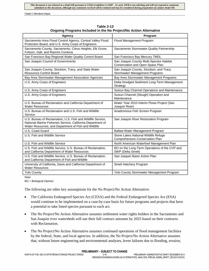
Table 2-13Ongoing Programs Included in the No Project/No Action Alternative
Agency Program
California Department of Boating and Waterways Egeria Densa Control Programs
California Department of Boating and Waterways Water Hyacinth Control Programs
California Department of Fish and Wildlife Invasive Species Program
California Department of Fish and Wildlife California Aquatic Invasive Species ManagementPlan
California Department of Fish and Wildlife Zebra Mussel Rapid Watch Program and ResponsePlan for California
California Department of Fish and Wildlife Fish Screen Passage Program
California Department of Fish and Wildlife Delta-Bay Enhanced Enforcement Program
California Department of Fish and Wildlife Ecosystem Restoration Program ConservationStrategy
California Department of Fish and Wildlife Lower Sherman Island Wildlife Area LandManagement Plan
California Department of Fish and Wildlife Yolo Bypass Wildlife Area Land Management Plan
California Department of Fish and Wildlife and U.S. Fish andWildlife Service
Hatchery and Stocking Program
California Department of Fish and Wildlife, CaliforniaDepartment of Food and Agriculture, and California StateParks
Watercraft Inspection Programs
California Department of Water Resources Delta Levees Flood Protection Program
California Department of Water Resources Levee Repair-Levee Evaluation Program
California Department of Water Resources Interagency Ecological Program
California Department of Water Resources South Delta Temporary Barriers Program
California Department of Water Resources Stockton Deep Water Ship Channel DemonstrationDissolved Oxygen Project
California Department of Water Resources Zebra Mussel Watch Program
California Department of Water Resources and CaliforniaDepartment of Fish and Wildlife
Delta Fish Agreement (Four Pumps Project)
California Department of Water Resources and Yuba CountyWater Agency
Lower Yuba River Accord
California State Lands Commission Marine Invasive Species Program
Central Valley Regional Water Quality Control Board Cache Creek, Bear Creek, Sulfur Creek, HarleyGulch Mercury TMDL
Central Valley Regional Water Quality Control Board Irrigated Lands Regulatory Program
California Partners in Flight Riparian Habitat Joint Venture
Central Valley Joint Venture Program Central Valley Joint Venture
Contra Costa County and East Contra Costa County HabitatConservancy
East Contra Costa County Habitat ConservationPlan and Natural Community Conservation Plan
Delta Protection Commission Delta Protection Commission Land Use andResource Management Plan Update
East Bay Municipal Utility District Lower Mokelumne River Spawning HabitatImprovement Project
National Marine Fisheries Service, Bureau of Reclamation,and California Department of Water Resources
BO on the Long-Term Operations of the CVP andSWP (Sacramento River Winter-run ChinookSalmon, Central Valley Spring-run Chinook Salmon,Central Valley Steelhead, Southern DistinctPopulation Segment of North American GreenSturgeon, and Southern Resident Killer Whales)
Sacramento County Sacramento International Airport Master Plan
This document is not released as a draft EIR pursuant to CEQA Guidelines § 15087. As such, DWR is not soliciting and will not respond to commentssubmitted on this document, although any comments received will be retained and may be considered during preparation of a future draft EIR.
Chapter 2: Alternatives Analysis
PRELIMINARY – SUBJECT TO CHANGENORTH-OF-THE- DELTA OFFSTREAM STORAGE PROJECT EIR/EIS 2-16 PRELIMINARY ADMINISTRATIVE DRAFT DECEMBER 2013
WBG020812033556SAC/433094 (02-ALTERNATIVES_ANALYSIS_PRELIM_ADMIN_DRAFT_DEC2013.DOCX)
Table 2-13Ongoing Programs Included in the No Project/No Action Alternative
Agency Program
Sacramento Area Flood Control Agency, Central Valley FloodProtection Board, and U.S. Army Corps of Engineers
Flood Management Program
Sacramento County, Sacramento, Citrus Heights, Elk Grove,Folsom, Galt, and Rancho Cordova
Sacramento Stormwater Quality Partnership
San Francisco Bay Regional Water Quality Control Board San Francisco Bay Mercury TMDL
San Joaquin Council of Governments San Joaquin County Multi-Species HabitatConservation and Open Space Plan
San Joaquin County, Stockton, Tracy, and State WaterResources Control Board
San Joaquin County, Stockton, and TracyStormwater Management Programs
Bay Area Stormwater Management Association Agencies Bay Area Stormwater Management Programs
U.S. Army Corps of Engineers Delta Dredged Sediment Long-Term ManagementStrategy
U.S. Army Corps of Engineers Suisun Bay Channel Operations and Maintenance
U.S. Army Corps of Engineers Suisun Channel (Slough) Operation andMaintenance
U.S. Bureau of Reclamation and California Department ofWater Resources
Water Year 2010 Interim Flows Project (SanJoaquin River)
U.S. Bureau of Reclamation and U.S. Fish and WildlifeService
Anadromous Fish Screen Program
U.S. Bureau of Reclamation, U.S. Fish and Wildlife Service,National Marine Fisheries Service, California Department ofWater Resources, and Department of Fish and Wildlife
San Joaquin River Restoration Program
U.S. Coast Guard Ballast Water Management Program
U.S. Fish and Wildlife Service Stone Lakes National Wildlife RefugeComprehensive Conservation Plan
U.S. Fish and Wildlife Service North American Waterfowl Management Plan
U.S. Fish and Wildlife Service, U.S. Bureau of Reclamation,and California Department of Water Resources
BO on the Long-Term Operations of the CVP andSWP (Delta Smelt)
U.S. Fish and Wildlife Service, U.S. Bureau of Reclamation,and California Department of Fish and Wildlife
San Joaquin Basin Action Plan
University of California, Davis and California Department ofWater Resources
Smelt Hatchery Program
Yolo County Yolo County Stormwater Management Program
Note:
BO = Biological Opinion
The following are other key assumptions for the No Project/No Action Alternative:
The California Endangered Species Act (CESA) and the Federal Endangered Species Act (ESA)
would continue to be implemented on a case-by-case basis for future programs and projects that have
a potential to take listed species pursuant to each act.
The No Project/No Action Alternative assumes settlement water rights holders in the Sacramento and
San Joaquin river watersheds will use their full contract amounts by 2025 based on their contracts
with Reclamation.
The No Project/No Action Alternative assumes continued operations of flood management facilities
by the federal, State, and local agencies. In addition, the No Project/No Action Alternative assumes
that, without future engineering and environmental analyses, levee failures due to flooding, erosion,
This document is not released as a draft EIR pursuant to CEQA Guidelines § 15087. As such, DWR is not soliciting and will not respond to commentssubmitted on this document, although any comments received will be retained and may be considered during preparation of a future draft EIR.
Chapter 2: Alternatives Analysis
PRELIMINARY – SUBJECT TO CHANGEPRELIMINARY ADMINISTRATIVE DRAFT DECEMBER 2013 2-17 NORTH-OF-THE- DELTA OFFSTREAM STORAGE PROJECT EIR/EISWBG020812033556SAC/433094 (02-ALTERNATIVES_ANALYSIS_PRELIM_ADMIN_DRAFT_DEC2013.DOCX)
subsidence, wave action, seismic events, burrowing animals, physical encroachment (such as barge
collisions), or other causes would be repaired as part of ongoing programs. The No Project/No Action
Alternative assumes that these repairs also would occur on privately owned levees that are integral to
the main waterways in the Delta, such as repairs that occurred to privately owned levees following the
1996 and 1997 floods.
The No Project/No Action Alternative also includes existing facilities for SWP, CVP, and Contra
Costa Water District, and the Tehama-Colusa Canal and Glenn-Colusa Irrigation District Canal.
Summary descriptions of these facilities are provided in Appendix 2D.
Operations of the SWP and CVP by DWR and Reclamation, respectively, are described in the
August 2008 Biological Assessment for the Long-term OCAP for the CVP and SWP prepared by
Reclamation and modified by the 2009 NMFS BO and 2008 USFWS BO.
SWP and CVP operational assumptions also include continued operations under the Coordinated
Operations Agreement; SWRCB Decision 1641 (D-1641); use of Joint Points of Diversion (which
allows DWR and Reclamation to use both the SWP and CVP diversion capacity capabilities in
accordance with D-1641); SWRCB Water Quality Control Plan adopted in 2006; and implementation
of the Central Valley Project Improvement Act including environmental water actions in accordance
with Section 3406(b)(2).
The No Project/No Action Alternative assumes completion of the RBDD Fish Passage Improvement
Project, and year-round gates out operations.
The No Project/No Action Alternative does not assume new Delta conveyance facilities to be in place,
rather Delta exports would continue to be pumped through the Banks and Jones pumping plants.
The No Project/No Action Alternative does not include assumptions of future changes in facilities
operations, land use, or policies to accommodate or mitigate the adverse impacts associated with
climate change.
The No Project/No Action Alternative does not include assumptions for climate change related to sea
level rise and changes in precipitation patterns, including changes in ratios between snow and rainfall.
A sensitivity analysis to account for climate change effects on the proposed Project was performed
and is presented in Chapter 25 Climate Change and Greenhouse Gas Emissions.
Population growth is expected to continue to occur in California throughout the period of project
analysis (i.e., 100 years).
2.3.3 Sites Reservoir Alternative
The description of the Sites Reservoir Alternative was developed to include details for the appurtenant
facilities shown in Figures 2-2 and 2-3. Evaluation of the alternative continued to focus on a 1.8-MAF
reservoir size, although a range of reservoir sizes were also considered.
During this phase of the investigation, non-irrigation season flows in the CBD, the Sacramento River, and
local tributaries remained potential sources of water supply for the offstream Sites Reservoir Alternative.
Potential conveyance systems from these sources to the reservoir included existing and/or enlarged
Tehama-Colusa (T-C) and Glenn-Colusa Irrigation District (GCID) canals, or a new conveyance facility
from the Sacramento River near Moulton Weir and/or from the CBD to the existing Funks Reservoir on
This document is not released as a draft EIR pursuant to CEQA Guidelines § 15087. As such, DWR is not soliciting and will not respond to commentssubmitted on this document, although any comments received will be retained and may be considered during preparation of a future draft EIR.

Chapter 2: Alternatives Analysis
PRELIMINARY – SUBJECT TO CHANGENORTH-OF-THE- DELTA OFFSTREAM STORAGE PROJECT EIR/EIS 2-18 PRELIMINARY ADMINISTRATIVE DRAFT DECEMBER 2013
WBG020812033556SAC/433094 (02-ALTERNATIVES_ANALYSIS_PRELIM_ADMIN_DRAFT_DEC2013.DOCX)
the T-C Canal. Conveyance from Stony Creek was also considered. All conveyance alternatives required
enlargement of the existing Funks Reservoir to provide adequate storage capacity for pumping of water
into the reservoir and hydropower generation. Major project facilities would be situated near the Funks
Creek damsite, including outlet works, power plant, intake structure, and maintenance facilities.
Additionally, up to five potential recreation facility locations were identified to meet the secondary
objective of developing additional recreation opportunities in the study area.
Construction of Sites Reservoir would require relocation of two county roads (Sites Lodoga and
Huffmaster roads) and the community of Sites.
2.3.4 Newville Reservoir Alternative
The description for the Newville Reservoir Alternative was also developed and refined to include details for
the appurtenant facilities shown in Figures 2-4, 2-5, 2-6, and 2-7. Evaluation of the alternative focused on the
1.9-MAF reservoir size. A 3.0-MAF reservoir size was also considered and evaluated. However, all of the
environmental and cultural resources effects, as well as the cost, of the 3.0- MAF reservoir would be additive
to those of the 1.9-MAF reservoir. The 3.0-MAF Newville Reservoir was therefore not evaluated further.
The Sacramento River and existing Black Butte Reservoir were considered, in addition to Thomes Creek,
as potential sources of water supply for the Newville Reservoir Alternative. Potential conveyance systems
from these sources to the reservoir included the existing or enlarged T-C Canal with a new conveyance
between the GCID and T-C canals, a new conveyance from the T-C Canal to the existing Black Butte
Reservoir, and a new conveyance from Black Butte Reservoir to the Newville Reservoir Alternative. A
new conveyance from a proposed Thomes Creek diversion at a location north and west of the Newville
Reservoir Alternative was also considered. Additionally, five potential recreation areas were identified to
meet the secondary objective of developing additional recreation opportunities in the study area.
Construction of the Newville Reservoir Alternative would require relocation of portions of three county
roads, including Round Valley Road, Garland Road, and County Road 306.
2.4 Resource Impact Comparison for Selected Alternatives
A review of potential impacts to biological and cultural resources for the Sites Reservoir and NewvilleReservoir alternatives indicated a greater impact potential for the Newville Reservoir Alternative. Potentialimpacts for both reservoir alternatives, as well as the No Project/No Action Alternative, are described below.
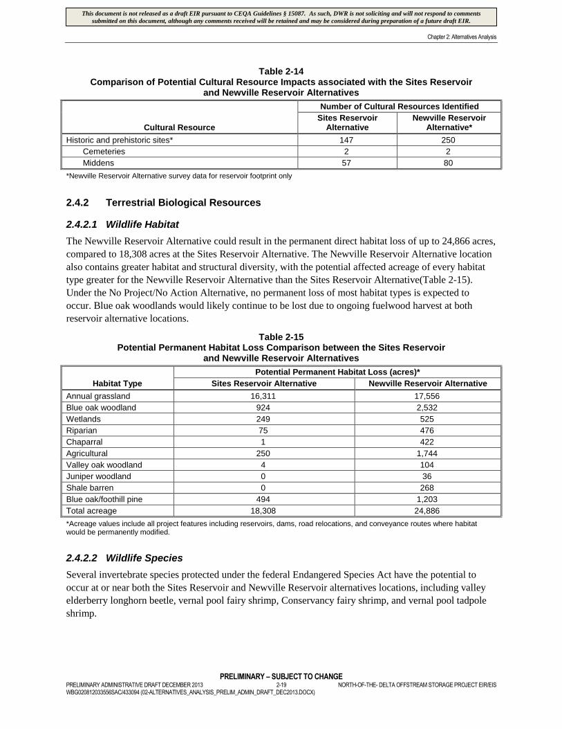
2.4.1 Cultural Resources
Table 2-14 presents a comparison of the cultural resources survey results for the Sites Reservoir (1.8-
MAF) and Newville Reservoir (1.9-MAF) alternatives. Newville Reservoir Alternative data represent
totals for the reservoir footprint only, while Sites Reservoir Alternative data include data associated with
all major proposed Project facilities, including conveyance routes, road relocations, recreation areas,
hydropower facilities, and a terminal regulating reservoir. Despite the smaller survey area, the Newville
Reservoir Alternative location contains substantially more cultural resources than the Sites Reservoir
Alternative location, including more middens. Middens are indicative of long periods of site occupation
and are an important cultural resource, as they can be expected to yield substantial cultural information
and human remains. Under the No Project/No Action Alternative, no impacts to cultural resources or
cemeteries are expected.
This document is not released as a draft EIR pursuant to CEQA Guidelines § 15087. As such, DWR is not soliciting and will not respond to commentssubmitted on this document, although any comments received will be retained and may be considered during preparation of a future draft EIR.
Chapter 2: Alternatives Analysis
PRELIMINARY – SUBJECT TO CHANGEPRELIMINARY ADMINISTRATIVE DRAFT DECEMBER 2013 2-19 NORTH-OF-THE- DELTA OFFSTREAM STORAGE PROJECT EIR/EISWBG020812033556SAC/433094 (02-ALTERNATIVES_ANALYSIS_PRELIM_ADMIN_DRAFT_DEC2013.DOCX)
Table 2-14Comparison of Potential Cultural Resource Impacts associated with the Sites Reservoir
and Newville Reservoir Alternatives
Cultural Resource
Number of Cultural Resources Identified
Sites ReservoirAlternative
Newville ReservoirAlternative*
Historic and prehistoric sites* 147 250
Cemeteries 2 2
Middens 57 80
*Newville Reservoir Alternative survey data for reservoir footprint only
2.4.2 Terrestrial Biological Resources
2.4.2.1 Wildlife Habitat
The Newville Reservoir Alternative could result in the permanent direct habitat loss of up to 24,866 acres,
compared to 18,308 acres at the Sites Reservoir Alternative. The Newville Reservoir Alternative location
also contains greater habitat and structural diversity, with the potential affected acreage of every habitat
type greater for the Newville Reservoir Alternative than the Sites Reservoir Alternative(Table 2-15).
Under the No Project/No Action Alternative, no permanent loss of most habitat types is expected to
occur. Blue oak woodlands would likely continue to be lost due to ongoing fuelwood harvest at both
reservoir alternative locations.
Table 2-15Potential Permanent Habitat Loss Comparison between the Sites Reservoir
and Newville Reservoir Alternatives
Habitat Type
Potential Permanent Habitat Loss (acres)*
Sites Reservoir Alternative Newville Reservoir Alternative
Annual grassland 16,311 17,556
Blue oak woodland 924 2,532
Wetlands 249 525
Riparian 75 476
Chaparral 1 422
Agricultural 250 1,744
Valley oak woodland 4 104
Juniper woodland 0 36
Shale barren 0 268
Blue oak/foothill pine 494 1,203
Total acreage 18,308 24,886
*Acreage values include all project features including reservoirs, dams, road relocations, and conveyance routes where habitatwould be permanently modified.
2.4.2.2 Wildlife Species
Several invertebrate species protected under the federal Endangered Species Act have the potential to
occur at or near both the Sites Reservoir and Newville Reservoir alternatives locations, including valley
elderberry longhorn beetle, vernal pool fairy shrimp, Conservancy fairy shrimp, and vernal pool tadpole
shrimp.
This document is not released as a draft EIR pursuant to CEQA Guidelines § 15087. As such, DWR is not soliciting and will not respond to commentssubmitted on this document, although any comments received will be retained and may be considered during preparation of a future draft EIR.
Chapter 2: Alternatives Analysis
PRELIMINARY – SUBJECT TO CHANGENORTH-OF-THE- DELTA OFFSTREAM STORAGE PROJECT EIR/EIS 2-20 PRELIMINARY ADMINISTRATIVE DRAFT DECEMBER 2013
WBG020812033556SAC/433094 (02-ALTERNATIVES_ANALYSIS_PRELIM_ADMIN_DRAFT_DEC2013.DOCX)
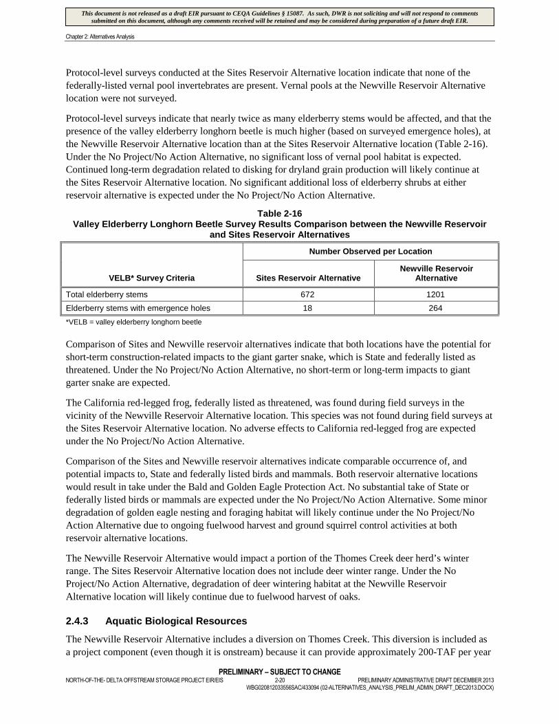
Protocol-level surveys conducted at the Sites Reservoir Alternative location indicate that none of the
federally-listed vernal pool invertebrates are present. Vernal pools at the Newville Reservoir Alternative
location were not surveyed.
Protocol-level surveys indicate that nearly twice as many elderberry stems would be affected, and that the
presence of the valley elderberry longhorn beetle is much higher (based on surveyed emergence holes), at
the Newville Reservoir Alternative location than at the Sites Reservoir Alternative location (Table 2-16).
Under the No Project/No Action Alternative, no significant loss of vernal pool habitat is expected.
Continued long-term degradation related to disking for dryland grain production will likely continue at
the Sites Reservoir Alternative location. No significant additional loss of elderberry shrubs at either
reservoir alternative is expected under the No Project/No Action Alternative.
Table 2-16Valley Elderberry Longhorn Beetle Survey Results Comparison between the Newville Reservoir
and Sites Reservoir Alternatives
VELB* Survey Criteria
Number Observed per Location
Sites Reservoir AlternativeNewville Reservoir
Alternative
Total elderberry stems 672 1201
Elderberry stems with emergence holes 18 264
*VELB = valley elderberry longhorn beetle
Comparison of Sites and Newville reservoir alternatives indicate that both locations have the potential for
short-term construction-related impacts to the giant garter snake, which is State and federally listed as
threatened. Under the No Project/No Action Alternative, no short-term or long-term impacts to giant
garter snake are expected.
The California red-legged frog, federally listed as threatened, was found during field surveys in the
vicinity of the Newville Reservoir Alternative location. This species was not found during field surveys at
the Sites Reservoir Alternative location. No adverse effects to California red-legged frog are expected
under the No Project/No Action Alternative.
Comparison of the Sites and Newville reservoir alternatives indicate comparable occurrence of, and
potential impacts to, State and federally listed birds and mammals. Both reservoir alternative locations
would result in take under the Bald and Golden Eagle Protection Act. No substantial take of State or
federally listed birds or mammals are expected under the No Project/No Action Alternative. Some minor
degradation of golden eagle nesting and foraging habitat will likely continue under the No Project/No
Action Alternative due to ongoing fuelwood harvest and ground squirrel control activities at both
reservoir alternative locations.
The Newville Reservoir Alternative would impact a portion of the Thomes Creek deer herd’s winter
range. The Sites Reservoir Alternative location does not include deer winter range. Under the No
Project/No Action Alternative, degradation of deer wintering habitat at the Newville Reservoir
Alternative location will likely continue due to fuelwood harvest of oaks.
2.4.3 Aquatic Biological Resources
The Newville Reservoir Alternative includes a diversion on Thomes Creek. This diversion is included as
a project component (even though it is onstream) because it can provide approximately 200-TAF per year
This document is not released as a draft EIR pursuant to CEQA Guidelines § 15087. As such, DWR is not soliciting and will not respond to commentssubmitted on this document, although any comments received will be retained and may be considered during preparation of a future draft EIR.

Chapter 2: Alternatives Analysis
PRELIMINARY – SUBJECT TO CHANGEPRELIMINARY ADMINISTRATIVE DRAFT DECEMBER 2013 2-21 NORTH-OF-THE- DELTA OFFSTREAM STORAGE PROJECT EIR/EISWBG020812033556SAC/433094 (02-ALTERNATIVES_ANALYSIS_PRELIM_ADMIN_DRAFT_DEC2013.DOCX)
of additional water to storage by gravity (without requiring pumping). Subsequent engineering evaluation
indicated substantial design difficulties in providing a suitable diversion which can pass both fish and
sediment at this location. This diversion would result in substantial adverse effects to spring-run Chinook
salmon, steelhead, and sediment passage. Without feasible fish passage measures, adverse effects to
anadromous fisheries would occur. These adverse effects would not be consistent with the NODOS
Project primary planning objective of increased survival of anadromous fish populations, or CALFED’s
direction to avoid significant redirected impacts including those associated with new onstream reservoirs.
By comparison, the tributary streams that would be affected by the Sites Reservoir Alternative, which
include Stone Corral and Funks creeks, are ephemeral and do not support anadromous fisheries.
Under the No Project/No Action Alternative, no changes to anadramous fish habitat or populations are
expected at either reservoir alternative location. However, many programs and projects included under the
No Project/No Action Alternative are designed specifically to improve fish habitat and increase fish
populations in the Sacramento Valley and Delta, including the Red Bluff Diversion Dam Fish Passage
Improvement Project, Battle Creek Salmon and Steelhead Restoration Project, Contra Costa Canal Fish
Screen Project, American Basin Fish Screen and Habitat Improvement Project, the CDFW Fish Screen and
Passage Program, Delta Fish Agreement, OCAP Biological Opinions, and the Lower Yuba River Accord.
2.4.4 Botanical Resources
Field studies indicate that the Newville Reservoir Alternative contains greater numbers of rare plant
species, higher priority plant species, and greater numbers of rare plant populations than the Sites
Reservoir Alternative (Table 2-17). No substantial impacts to rare plant populations are expected at either
reservoir alternative location under the No Project/No Action Alternative. Continued minor degradation
of some rare plant populations will likely occur due to land use practices such as dryland farming, year-
round grazing, and herbicide use.
Table 2-17Comparison of Rare Plant Species and Populations at the Sites
and Newville Reservoir Alternatives
Listing Status
Number of Rare Plants Observed (species/populations)
Sites Reservoir Alternative Newville Reservoir Alternative
State or federal threatened orendangered
0 0
State or federal species of concern 0 3/57
CNPS 1A 0 0
CNPS 1B 0 5/122
CNPS 2 0 0
CNPS 3 0 0
CNPS 4 4/37 7/183
Note:
CNPS=California Native Plant Society List
2.4.5 Wetlands and Waters of the U.S.
Comparison of the Newville and Sites reservoir alternatives indicates that the Newville Reservoir
Alternative would impact significantly greater amounts of wetlands and waters of the U.S. (Table 2-18),
This document is not released as a draft EIR pursuant to CEQA Guidelines § 15087. As such, DWR is not soliciting and will not respond to commentssubmitted on this document, although any comments received will be retained and may be considered during preparation of a future draft EIR.

Chapter 2: Alternatives Analysis
PRELIMINARY – SUBJECT TO CHANGENORTH-OF-THE- DELTA OFFSTREAM STORAGE PROJECT EIR/EIS 2-22 PRELIMINARY ADMINISTRATIVE DRAFT DECEMBER 2013
WBG020812033556SAC/433094 (02-ALTERNATIVES_ANALYSIS_PRELIM_ADMIN_DRAFT_DEC2013.DOCX)
including jurisdictional wetlands, than the Sites Reservoir Alternative. No substantial loss of wetlands or
waters of the U.S. are expected at either reservoir alternative location under the No Project/No Action
Alternative. Minor continued degradation of vernal pool habitats will likely continue due to disking for
dryland grain farming.
Table 2-18Comparison of Potential Impacts to Wetlands and Waters of the U.S. between the Sites and
Newville Reservoir Alternatives.
Resource
Wetlands and Waters of the U.S. Potentially Impacted (acres)
Sites Reservoir Alternative Newville Reservoir Alternative
Wetlands 196 390
Waters of the U.S. 175 231
Total wetlands and waters* 371 621
*Reservoir footprint data comparisons
2.4.6 Energy and Greenhouse Gas Emissions
The Newville Reservoir Alternative would require more energy for pumping than the Sites Reservoir
Alternative because minimum conveyance distances would be greater (18 to 23 miles for Newville
Reservoir, compared to one to 13 miles for Sites Reservoir), more pumping plants would be required, and
higher pumping elevations (approximately 400 feet higher pumping elevation for Newville Reservoir)
would be required for conveyance for Newville Reservoir Alternative. Higher conveyance-related energy
requirements associated with the Newville Reservoir Alternative would result in relatively greater
operational greenhouse gas emissions than for the Sites Reservoir Alternative. In addition, due to its greater
embankment volume (35 million cubic yards for the Newville Reservoir Alternative vs. 22 million cubic
yards for the Sites Reservoir Alternative), the Newville Reservoir Alternative would result in greater
construction equipment hours and, therefore, greater GHG emissions during construction. Under the No
Project/No Action Alternative, little change in the current levels of GHG emissions is expected because
agricultural cultivation is the largest contributor of GHG emissions within the reservoir alternative
locations, and the amount of land under cultivation at those locations is not expected to change.
2.4.7 Surface Water Resources
The Sites Reservoir Alternative would increase water supply reliability for agricultural, municipal,
industrial, and environmental water users. The Newville Reservoir Alternative would increase water
supply reliability for agricultural water users in the Sacramento Valley directly, and then potentially for
other users by exchange. Elimination of the Thomes Creek Diversion for the Newville Reservoir
Alternative due to its infeasibility would significantly increase the alternative’s construction costs, as
other water sources 1) require much longer and more expensive conveyances, and 2) would have long-
term greater operational costs, as they require pumpage instead of gravity to fill or refill the reservoir.
Water supply reliability would be improved under the No Project/No Action Alternative with
implementation of the many projects and programs included in the No Project/No Action Alternative,
including South Bay Aqueduct Improvement and Enlargement Project, Freeport Regional Water Project,
Delta Mendota Canal-California Aqueduct Intertie, City of Stockton Delta Water Supply Project, Contra
Costa Water District’s Middle River Intake and Pump Station Project, and Los Vaqueros Reservoir
Expansion. Water supply reliability is increasingly linked to conservation measures issued under the
federal Endangered Species Act. Some fish restoration actions identified under the No Project/No Action
This document is not released as a draft EIR pursuant to CEQA Guidelines § 15087. As such, DWR is not soliciting and will not respond to commentssubmitted on this document, although any comments received will be retained and may be considered during preparation of a future draft EIR.
Chapter 2: Alternatives Analysis
PRELIMINARY – SUBJECT TO CHANGEPRELIMINARY ADMINISTRATIVE DRAFT DECEMBER 2013 2-23 NORTH-OF-THE- DELTA OFFSTREAM STORAGE PROJECT EIR/EISWBG020812033556SAC/433094 (02-ALTERNATIVES_ANALYSIS_PRELIM_ADMIN_DRAFT_DEC2013.DOCX)
Alternative may serve to expedite species recovery and ultimately result in improved water supply
reliability. Examples include the Red Bluff Diversion Dam Fish Passage Improvement Project, Battle
Creek Salmon and Steelhead Restoration Project, Contra Costa Canal Fish Screen Project, American
Basin Fish Screen and Habitat Improvement Project, the CDFW Fish Screen and Passage Program, Delta
Fish Agreement, OCAP Biological Opinions, and the Lower Yuba River Accord.
2.4.8 Flood Management
The Sites Reservoir Alternative could provide some local flood management benefits to lands that are
currently prone to flooding during high flow events on Funks and Stone Corral creeks; the Newville
Reservoir Alternative would have little flood management potential since the reservoir would be located
upstream of Black Butte Reservoir, an existing flood management facility. Diversion facilities on Thomes
Creek would have little or no ability to store water or provide downstream flood protection. Under the No
Project/No Action Alternative, the Folsom Dam Safety and Flood Damage Reduction Project would
improve flood protection for the Lower American River and the City of Sacramento.
2.4.9 Cost and Engineering Feasibility
Comparison of cost and engineering feasibility of the Sites and Newville reservoir alternatives indicate
that both alternatives are technically feasible. However, construction and operational costs would be
greater for the Newville Alternative due to greater embankment requirements, and greater conveyance
length and lift. Costs and engineering feasibility associated with the No Project/No Action Alternative are
not applicable.
2.4.10 Sites-Newville Impact Comparison Conclusion
Surveys indicated that the Sites Reservoir and Newville Reservoir Alternatives would have similar
potential impacts to giant garter snakes, State- and federally-listed birds and mammals, and that both
would result in take under the Bald and Golden Eagle Protection Act. However, surveys also indicated
that the Newville Reservoir Alternative would have a much higher potential for adverse impacts to
cultural resources, wildlife habitat and diversity, elderberry plants and the valley elderberry longhorn
beetle, the red-legged frog, deer winter range, rare plants and plant populations, and anadromous fish.
In addition, the Newville Reservoir Alternative would be more expensive to construct and operate than
the Sites Reservoir Alternative, and would result in relatively greater construction and operation-related
greenhouse gas emissions.
2.5 Preferred Proposed Project Alternative
DWR and Reclamation selected the Sites Reservoir Alternative as the preferred proposed Project
alternative to be retained for further study and more detailed evaluation because of the consistently higher
potential for biological and cultural resources impacts associated with the Newville Reservoir Alternative,
and because the Newville Reservoir Alternative would not avoid or reduce any of the significant adverse
effects associated with the Sites Reservoir Alternative.
Once the Sites Reservoir Alternative was identified as the preferred proposed Project alternative
(hereafter proposed Project), all other necessary proposed Project features were conceptually developed
and refined, including analyses of reservoir storage size, conveyance, and operational alternatives to
maximize achievement of the NODOS Project objectives.
This document is not released as a draft EIR pursuant to CEQA Guidelines § 15087. As such, DWR is not soliciting and will not respond to commentssubmitted on this document, although any comments received will be retained and may be considered during preparation of a future draft EIR.

Chapter 2: Alternatives Analysis
PRELIMINARY – SUBJECT TO CHANGENORTH-OF-THE- DELTA OFFSTREAM STORAGE PROJECT EIR/EIS 2-24 PRELIMINARY ADMINISTRATIVE DRAFT DECEMBER 2013
WBG020812033556SAC/433094 (02-ALTERNATIVES_ANALYSIS_PRELIM_ADMIN_DRAFT_DEC2013.DOCX)
2.5.1 Sites Reservoir Storage Size Alternatives
DWR and Reclamation considered various storage sizes of Sites Reservoir, including 800 TAF,
1.27 MAF, 1.81 MAF, and 2.1 MAF. These four storage sizes were selected to reflect a range of storage
values that would allow for a useful comparison of the costs and benefits estimates. These four storage
sizes also represent points on the cost curve where the proposed Project’s costs would change
significantly due to the need for new Project features, such as dams or embankments.
Table 2-19 presents a summary of each Sites Reservoir storage size that was initially considered,
including the total number of dams that would be required to impound Sites Reservoir and the total
embankment volume that would be required for each of the four storage sizes.
Table 2-19Summary of Dams and Embankment Volume of Potential Sites Reservoir Storage Sizes
Reservoir Storage(MAF)
Maximum WaterSurface Elevation
(feet)
Reservoir SurfaceArea
(acres)
Total Number ofDamsa
(main + saddle)
Total EmbankmentVolume
(CY)
0.80 440 10,200 2 + 3 6,900,000
1.27 480 12,400 2 + 7 11,018,400
1.81 520 14,200 2 + 9 22,009,000
2.10 540 15,100 2 + 7b 33,800,000aTotal number of dams includes the Sites and Golden Gate dams and the saddle dams.bSaddle dams 7, 8, and 9 become one continuous embankment for the 2.1-MAF reservoir.
Notes:
MAF = million acre-feetCY = cubic yards
Source: DWR, 2004
Based on a review of the reservoir rim topography, site geology, and a cursory evaluation of the
relationship between embankment volume and reservoir storage, DWR and Reclamation determined early
in the investigation that a 2.1-MAF reservoir may present significant design challenges. Reservoir
elevations at or above 540 feet elevation would likely require grouting of the lower saddle areas along the
relatively steep ridges of the eastern rim to ensure the proposed Project would perform satisfactorily. This
treatment, combined with the increasing relationship between embankment material volume and reservoir
surface elevations, would result in larger unit costs (reservoir cost per acre-foot of storage) for reservoir
elevations above 540 feet elevation. Therefore, the Sites Reservoir storage capacities below 540 feet
elevation were considered to be more economical on a unit cost basis. Limiting the maximum reservoir
elevation to 520 feet elevation would provide assurance that unknown conditions (such as leakage) on the
relatively steeper slopes of the eastern reservoir rim would not result in large increases in proposed
Project costs during the later stages of design. Therefore, a maximum reservoir elevation of 540 feet,
corresponding to a reservoir size of 2.1 MAF, was eliminated from further consideration. Reservoir
storage capacities of 800 TAF, 1.27 MAF, and 1.81 MAF were, therefore, carried forward for further
consideration, including initial alternative development and evaluation.
2.5.2 Sites Reservoir Conveyance Alternatives
Preliminary operations simulations indicated that 3,000 to 6,000 cfs of total inflow capacity would be
needed to reliably fill Sites Reservoir. Because Sites Reservoir would be located offstream, water would
need to be diverted to and released from the reservoir. As a result, diversion and conveyance facilities
This document is not released as a draft EIR pursuant to CEQA Guidelines § 15087. As such, DWR is not soliciting and will not respond to commentssubmitted on this document, although any comments received will be retained and may be considered during preparation of a future draft EIR.

Chapter 2: Alternatives Analysis
PRELIMINARY – SUBJECT TO CHANGEPRELIMINARY ADMINISTRATIVE DRAFT DECEMBER 2013 2-25 NORTH-OF-THE- DELTA OFFSTREAM STORAGE PROJECT EIR/EISWBG020812033556SAC/433094 (02-ALTERNATIVES_ANALYSIS_PRELIM_ADMIN_DRAFT_DEC2013.DOCX)
would be needed to transport water to Sites Reservoir, and to deliver water from Sites Reservoir to service
areas, the Sacramento River, and other locations to meet various water resources needs and uses.
It was determined that, to maximize operational flexibility, the diversion and conveyance facilities would
need to be able to:
Release water directly from Sites Reservoir to meet local needs in the vicinity of the existing GCID
and T-C canals
Release water in an integrated manner with existing CVP and SWP operations to facilitate meeting
additional needs throughout the Bay-Delta system
Release water directly to the Sacramento River to meet additional needs throughout the Bay-Delta
system and provide downstream benefits for Delta water quality and water supply reliability (through
additional supplies or alternative source) for CVP, SWP, and Level 4 wildlife refuge water supply.
Additionally, the ability to release water directly to the Sacramento River would allow Sites Reservoir
to respond to Delta emergencies, including releasing flows to repel saltwater intrusion following a
Delta levee failure.
Conveyance facilities alternatives that would divert water from the Sacramento River included the
existing GCID and T-C canals, and a new pipeline, known as the Delevan Pipeline. Tributary source
conveyance facilities alternatives included new pipelines from the CBD and Stony Creek. Conveyance
facilities alternatives that were evaluated initially had a range of capacity sizes, known as options (Table
2-20), and are illustrated schematically in Figure 2-8.
Table 2-20Conveyance Facilities Alternatives Considered for Sites Reservoir
Conveyance Facility Alternative Source Option Capacity Description
GCID Canala Sacramento River at Hamilton City Existing 1,800-cfs capacityExpand to 3,000-cfs capacityExpand to 4,000-cfs capacityExpand to 5,000-cfs capacity
T-C Canala Sacramento River at Red Bluff Existing 2,100-cfs capacityModify to 2,700-cfs capacityExpand to 4,000-cfs capacityExpand to 5,000-cfs capacity
Delevan Pipelineb Sacramento River opposite MoultonWeir
1,500-cfs capacity2,000-cfs capacity3,000-cfs capacity4,000-cfs capacity5,000-cfs capacity
Colusa Basin Pipelineb Colusa Basin Drain 1,000-cfs capacity3,000-cfs capacity
Stony Creek Pipelineb Stony Creek at Black Butte Afterbay 1,000-cfs capacity2,100-cfs capacity
aExisting conveyance facility.bProposed new conveyance facility.
Notes:
cfs = cubic feet per secondGCID = Glenn-Colusa Irrigation DistrictT-C = Tehama-Colusa
Source: DWR and Reclamation, 2008.
This document is not released as a draft EIR pursuant to CEQA Guidelines § 15087. As such, DWR is not soliciting and will not respond to commentssubmitted on this document, although any comments received will be retained and may be considered during preparation of a future draft EIR.
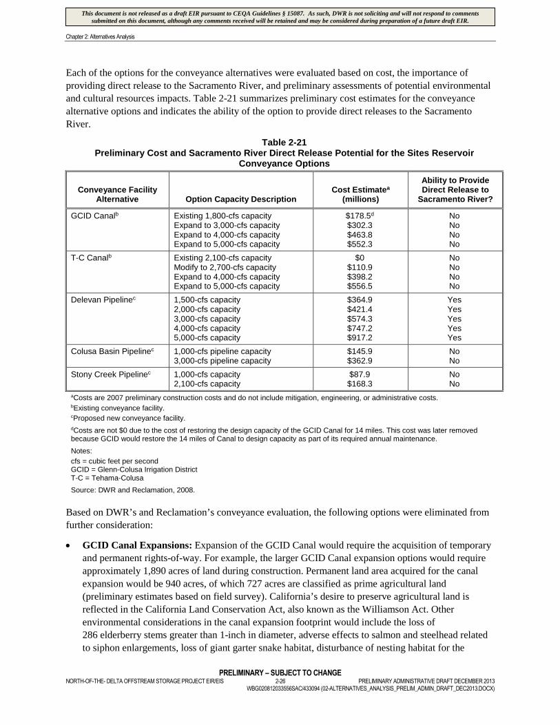
Chapter 2: Alternatives Analysis
PRELIMINARY – SUBJECT TO CHANGENORTH-OF-THE- DELTA OFFSTREAM STORAGE PROJECT EIR/EIS 2-26 PRELIMINARY ADMINISTRATIVE DRAFT DECEMBER 2013
WBG020812033556SAC/433094 (02-ALTERNATIVES_ANALYSIS_PRELIM_ADMIN_DRAFT_DEC2013.DOCX)
Each of the options for the conveyance alternatives were evaluated based on cost, the importance of
providing direct release to the Sacramento River, and preliminary assessments of potential environmental
and cultural resources impacts. Table 2-21 summarizes preliminary cost estimates for the conveyance
alternative options and indicates the ability of the option to provide direct releases to the Sacramento
River.
Table 2-21Preliminary Cost and Sacramento River Direct Release Potential for the Sites Reservoir
Conveyance Options
Conveyance FacilityAlternative Option Capacity Description
Cost Estimatea
(millions)
Ability to ProvideDirect Release to
Sacramento River?
GCID Canalb Existing 1,800-cfs capacityExpand to 3,000-cfs capacityExpand to 4,000-cfs capacityExpand to 5,000-cfs capacity
$178.5d
$302.3$463.8$552.3
NoNoNoNo
T-C Canalb Existing 2,100-cfs capacityModify to 2,700-cfs capacityExpand to 4,000-cfs capacityExpand to 5,000-cfs capacity
$0$110.9$398.2$556.5
NoNoNoNo
Delevan Pipelinec 1,500-cfs capacity2,000-cfs capacity3,000-cfs capacity4,000-cfs capacity5,000-cfs capacity
$364.9$421.4$574.3$747.2$917.2
YesYesYesYesYes
Colusa Basin Pipelinec 1,000-cfs pipeline capacity3,000-cfs pipeline capacity
$145.9$362.9
NoNo
Stony Creek Pipelinec 1,000-cfs capacity2,100-cfs capacity
$87.9$168.3
NoNo
aCosts are 2007 preliminary construction costs and do not include mitigation, engineering, or administrative costs.bExisting conveyance facility.cProposed new conveyance facility.
dCosts are not $0 due to the cost of restoring the design capacity of the GCID Canal for 14 miles. This cost was later removedbecause GCID would restore the 14 miles of Canal to design capacity as part of its required annual maintenance.
Notes:
cfs = cubic feet per secondGCID = Glenn-Colusa Irrigation DistrictT-C = Tehama-Colusa
Source: DWR and Reclamation, 2008.
Based on DWR’s and Reclamation’s conveyance evaluation, the following options were eliminated from
further consideration:
GCID Canal Expansions: Expansion of the GCID Canal would require the acquisition of temporary
and permanent rights-of-way. For example, the larger GCID Canal expansion options would require
approximately 1,890 acres of land during construction. Permanent land area acquired for the canal
expansion would be 940 acres, of which 727 acres are classified as prime agricultural land
(preliminary estimates based on field survey). California’s desire to preserve agricultural land is
reflected in the California Land Conservation Act, also known as the Williamson Act. Other
environmental considerations in the canal expansion footprint would include the loss of
286 elderberry stems greater than 1-inch in diameter, adverse effects to salmon and steelhead related
to siphon enlargements, loss of giant garter snake habitat, disturbance of nesting habitat for the
This document is not released as a draft EIR pursuant to CEQA Guidelines § 15087. As such, DWR is not soliciting and will not respond to commentssubmitted on this document, although any comments received will be retained and may be considered during preparation of a future draft EIR.

Chapter 2: Alternatives Analysis
PRELIMINARY – SUBJECT TO CHANGEPRELIMINARY ADMINISTRATIVE DRAFT DECEMBER 2013 2-27 NORTH-OF-THE- DELTA OFFSTREAM STORAGE PROJECT EIR/EISWBG020812033556SAC/433094 (02-ALTERNATIVES_ANALYSIS_PRELIM_ADMIN_DRAFT_DEC2013.DOCX)
Swainson’s hawk, and extensive loss of jurisdictional wetlands, including vernal pools. The potential
impacts to prime agricultural land and environmental resources associated with these facilities
support the recommendation not to further evaluate GCID Canal expansions.
T-C Canal Modification and Expansions: There were 2,468 acres of agricultural land determined to
be within 100 feet of the T-C Canal modification and expansion area footprint; of these, 1,244 acres
are classified as prime agricultural land (preliminary estimates based on field survey). Environmental
considerations in the expansion area footprint would include the loss of vernal pool plants and
invertebrates, loss of California tiger salamander habitat, loss of 170 elderberry stems greater than 1-
inch in diameter, adverse effects to salmon and steelhead related to siphon enlargements, potential
giant garter snake habitat loss, disturbance of nesting habitat for the Swainson’s hawk, and loss of
jurisdictional wetlands, including vernal pools. These potential impacts to prime agricultural land and
environmental resources support the recommendation not to further evaluate T-C Canal modifications
or expansion.
4,000 and 5,000 cfs Delevan Pipeline: These options were determined to be inefficient and
infeasible due to cost, which would be $747 million and $917 million, respectively. These
preliminary construction cost estimates are presented in 2007 dollars and do not include mitigation,
engineering, or administrative costs. Additionally, the smaller pipeline sizes were determined to be
able to reliably fill and drain Sites Reservoir when combined with other conveyance options.
Colusa Basin Pipeline: The water from the CBD is considered to be of relatively poor water quality
when compared to Sacramento River water and is, therefore, less desirable. The CBD is the single
largest source of agricultural return flows to the Sacramento River; as a result, it has elevated values
for alkalinity, electrical conductivity, and total dissolved solids. Nitrogen and phosphorus
concentrations also are generally higher in the CBD. Water taken from the CBD into Sites Reservoir
and then released back through the conveyance system could cause water quality impacts to local
agricultural users and create a new point source of relatively lower quality water if discharged into the
Sacramento River. Therefore, neither Colusa Basin Pipeline conveyance option was recommended for
further consideration.
Stony Creek Pipeline: The Stony Creek Pipeline conveyance options would rely on increased
capacity of the T-C Canal downstream of Orland. The T-C Canal modification and expansion
conveyances were eliminated from further consideration (as indicated above); therefore, the Stony
Creek Pipeline conveyance options were also eliminated from further consideration.
The conveyance options retained were:
T-C Canal at its existing capacity of 2,100 cfs
GCID Canal at its existing capacity of 1,800 cfs
A new Delevan Pipeline at capacities of 1,500 cfs, 2,000 cfs, and 3,000 cfs
The T-C and GCID canals at their existing capacities would be the most cost-effective conveyance
options. These conveyance options were retained because they could be combined to provide conveyance
packages with up to 6,900 cfs total capacity for use in initial alternative development. In addition, these
conveyance options allowed for an evaluation of benefits associated with the proposed Delevan Pipeline’s
ability to return water directly to the Sacramento River.
This document is not released as a draft EIR pursuant to CEQA Guidelines § 15087. As such, DWR is not soliciting and will not respond to commentssubmitted on this document, although any comments received will be retained and may be considered during preparation of a future draft EIR.
Chapter 2: Alternatives Analysis
PRELIMINARY – SUBJECT TO CHANGENORTH-OF-THE- DELTA OFFSTREAM STORAGE PROJECT EIR/EIS 2-28 PRELIMINARY ADMINISTRATIVE DRAFT DECEMBER 2013
WBG020812033556SAC/433094 (02-ALTERNATIVES_ANALYSIS_PRELIM_ADMIN_DRAFT_DEC2013.DOCX)
2.5.3 Sites Reservoir Operational Alternatives
Eight initial Sites Reservoir operational alternatives, each with a range of conveyance packages and
operational emphases, were considered and evaluated with the CalSim-II operations model in the NODOS
Plan Formulation Report (DWR and Reclamation, 2008). The operational alternatives assumed a Sites
Reservoir storage size of 1.8 MAF. All of the initial Project operational alternatives evaluated met the
proposed Project’s primary objectives, but to varying degrees. The proposed Project operational
alternative that emphasized a balanced mix of benefits to water supply reliability, water quality, and
ecosystem enhancement generated the greatest net annual economic benefit and minimized environmental
impacts, and therefore was selected as the operational scenario for detailed evaluation in this
environmental document. This operational alternative was the only one evaluated that resulted in
economic benefits that exceeded costs (i.e. benefit-cost ratio greater than 1.0). The other operational
alternatives that prioritized one benefit category (i.e. water supply reliability, water quality, or ecosystem
enhancement) were eliminated from further consideration.
2.5.4 Sites Reservoir Storage, Conveyance, and Operations Formulation
Based on the initial evaluation of storage, conveyance and operational alternatives, the following
proposed Project features were retained for further evaluation:
Sites Reservoir Storage: 800 TAF, 1.27 MAF, and 1.81 MAF
Sites Reservoir Conveyance: existing T-C Canal (2,100-cfs capacity), existing GCID Canal (1,800-
cfs capacity), and new Delevan Pipeline (1,500-cfs, 2,000-cfs, and 3,000-cfs capacity)
Operational scenario that emphasized a balanced mix of benefits to water supply reliability, water
quality, and ecosystem enhancement
To further evaluate and optimize reservoir storage and conveyance options, preliminary costs were
estimated and operations modeling was performed. Table 2-22 identifies the reservoir storage and
conveyance facility options that were evaluated and their associated total capital costs.
The purpose of the operations modeling was to reduce the number of possible Project combinations and to
help formulate Sites Reservoir alternatives with the most efficient conveyance options and reservoir
storage sizes. The operations simulations modeling was performed using an assumed operational scenario
that provided a balanced mix of water supply reliability, water quality, and ecosystem enhancement. This
operational scenario was similar to the operational scenario described above that generated the greatest
net economic benefits. The water supply yield of the conveyance options and Sites Reservoir storage
combinations was analyzed for long-term average and driest period’s average hydrologic conditions.
Preliminary economic evaluation was performed to value the water supply yield benefits for each
combination. Net annual economic benefits were estimated and used as the primary economic metric to
rank and compare the combinations as shown in Table 2-23.
Based on the preliminary operations simulations described above, a 3,000-cfs Delevan Pipeline was
eliminated from consideration. Preliminary modeling results of the above-listed conveyance options
indicated that a 2,000-cfs conveyance was adequate to meet the proposed Project objectives. Constructing
a larger Delevan Pipeline would require a larger intake/discharge structure that would result in greater
environmental impacts due to its presence in an area that has sensitive habitat. Constructing a larger
pipeline would also significantly increase the construction cost and operational expense. Therefore, a
3,000-cfs Delevan Pipeline was not considered further.
This document is not released as a draft EIR pursuant to CEQA Guidelines § 15087. As such, DWR is not soliciting and will not respond to commentssubmitted on this document, although any comments received will be retained and may be considered during preparation of a future draft EIR.

Chapter 2: Alternatives Analysis
PRELIMINARY – SUBJECT TO CHANGEPRELIMINARY ADMINISTRATIVE DRAFT DECEMBER 2013 2-29 NORTH-OF-THE- DELTA OFFSTREAM STORAGE PROJECT EIR/EISWBG020812033556SAC/433094 (02-ALTERNATIVES_ANALYSIS_PRELIM_ADMIN_DRAFT_DEC2013.DOCX)
Table 2-22Sites Reservoir Storage and Conveyance Options Combinations
Reservoir Storage(TAF)
Conveyance
Capital Cost($Billion, 2007)*
T-C+GCIDCapacity
(cfs)
Delevan Pipeline TotalDiversionCapacity
(cfs)
DiversionCapacity
(cfs)
ReleaseCapacity
(cfs)
800 3,900 0 0 3,900 $1.96
800 3,900 1,500 1,125 5,400 $2.92
800 3,900 2,000 1,500 5,900 $3.13
800 3,900 3,000 2,250 6,900 $3.56
1,270 3,900 0 0 3,900 $2.22
1,270 3,900 1,500 1,125 5,400 $3.15
1,270 3,900 0 1,500 3,900 $3.09
1,270 3,900 2,000 1,500 5,900 $3.36
1,270 3,900 3,000 2,250 6,900 $3.79
1,810 3,900 0 0 3,900 $2.64
1,810 3,900 1,500 1,125 5,400 $3.56
1,810 3,900 0 1,500 3,900 $3.50
1,810 3,900 2,000 1,500 5,900 $3.77
1,810 3,900 0 2,250 3,900 $3.82
1,810 3,900 3,000 2,250 6,900 $4.19
*This date is associated with the cost estimates from the NODOS Investigation Plan Formulation Report (DWR and Reclamation2008).
Notes:
cfs = cubic feet per secondGCID = Glenn-Colusa Irrigation DistrictTAF = thousand acre-feetT-C = Tehama-Colusa
Source: DWR, 2011.
Table 2-23 presents a preliminary estimate of the net annual economic benefit that is associated with each
reservoir storage and conveyance options combination that was retained, ranked in order of highest to
lowest potential net annual economic benefit.
As shown in Table 2-23, the first three reservoir storage and conveyance options combinations are
estimated to perform much better than the remainder of the reservoir storage and conveyance options
combinations that were considered. These three reservoir size and conveyance options combinations were
combined with new hydropower facilities to develop three configurations of Sites Reservoir denoted as
Alternative A, Alternative B, and Alternative C in this DEIR/S. These action alternatives and the No
Project/No Action Alternative provided a range of alternatives for further refinement and detailed analysis
in the Feasibility Report and DEIR/EIS. The Red Bank, Colusa, Newville, and Sites reservoir alternatives
considered and described previously and these refined action alternatives together provide a reasonable
range and serve to meet the requirements of CEQA; NEPA; other pertinent federal, State, and local laws,
regulations, and policies; and the Principles and Guidelines (P&Gs) presented in the U.S. Water
Resources Council’s Economic and Environmental Principles and Guidelines for Water and Related
Land Resources Implementation Studies (USWRC,1983). Following is a brief description of the No
Project/No Action Alternative and Alternatives A, B, and C that are evaluated in this DEIR/EIS:
No Project/No Action Alternative: The No Project/No Action Alternative assumes that no actions
would be taken to provide storage north of the Delta to improve water supply reliability, to enhance
This document is not released as a draft EIR pursuant to CEQA Guidelines § 15087. As such, DWR is not soliciting and will not respond to commentssubmitted on this document, although any comments received will be retained and may be considered during preparation of a future draft EIR.

Chapter 2: Alternatives Analysis
PRELIMINARY – SUBJECT TO CHANGENORTH-OF-THE- DELTA OFFSTREAM STORAGE PROJECT EIR/EIS 2-30 PRELIMINARY ADMINISTRATIVE DRAFT DECEMBER 2013
WBG020812033556SAC/433094 (02-ALTERNATIVES_ANALYSIS_PRELIM_ADMIN_DRAFT_DEC2013.DOCX)
the survivability of anadromous fish or drinking water quality in the Delta, or to improve flexible
hydropower generation.
Alternative A – 1.27-MAF Sites Reservoir with Delevan Pipeline: Alternative A includes a 1.27-
MAF Sites Reservoir with conveyance to and from the reservoir provided by the existing T-C and
GCID canals and a new Delevan Pipeline (2,000-cfs diversion/1,500-cfs release). This alternative also
includes new hydropower facilities.
Alternative B – 1.81-MAF Sites Reservoir with Release-only Delevan Pipeline: Alternative B
includes a 1.81-MAF Sites Reservoir with conveyance to and from the reservoir provided by the
existing T-C and GCID canals, and a new release-only Delevan Pipeline (1,500-cfs release). This
alternative also includes new hydropower facilities.
Alternative C – 1.81-MAF Sites Reservoir with Delevan Pipeline: Alternative C includes a 1.81-
MAF Sites Reservoir with conveyance to and from the reservoir provided by the existing T-C and
GCID canals and a new Delevan Pipeline (2,000-cfs diversion/1,500-cfs release). This alternative also
includes new hydropower facilities.
Table 2-23Preliminary Net Economic Benefit Estimates for Sites Reservoir Storage and Conveyance Options
Combinations
Reservoir Storage(TAF)
Conveyance
Net Annual Benefit($Million, 2007)
TC+GCIDCapacity
(cfs)
Delevan PipelineTotal
DiversionCapacity
(cfs)
DiversionCapacity
(cfs)
ReleaseCapacity
(cfs)
1,810 3,900 0 1,500 3,900 $16.3
1,270 3,900 2,000 1,500 5,900 $16.2
1,810 3,900 2,000 1,500 5,900 $14.1
1,270 3,900 1,500 1,125 5,400 $7.6
1,810 3,900 1,500 1,125 5,400 $7.9
1,810 3,900 0 2,250 3,900 $4.1
1,270 3,900 0 1,500 3,900 -$0.7
800 3,900 1,500 1,125 5,400 -$14.1
800 3,900 2,000 1,500 5,900 -$17.4
1,270 3,900 0 0 3,900 -$18.1
800 3,900 0 0 3,900 -$23.0
1,810 3,900 0 0 3,900 -$33.7
Notes:
cfs = cubic feet per secondGCID = Glenn-Colusa Irrigation DistrictTAF = thousand acre-feetT-C = Tehama-Colusa
Source: DWR, 2011.
Maps and detailed descriptions of each of the proposed Project action alternatives, including descriptions
of construction, operation, and maintenance activities associated with each proposed Project feature, as
This document is not released as a draft EIR pursuant to CEQA Guidelines § 15087. As such, DWR is not soliciting and will not respond to commentssubmitted on this document, although any comments received will be retained and may be considered during preparation of a future draft EIR.
Chapter 2: Alternatives Analysis
PRELIMINARY – SUBJECT TO CHANGEPRELIMINARY ADMINISTRATIVE DRAFT DECEMBER 2013 2-31 NORTH-OF-THE- DELTA OFFSTREAM STORAGE PROJECT EIR/EISWBG020812033556SAC/433094 (02-ALTERNATIVES_ANALYSIS_PRELIM_ADMIN_DRAFT_DEC2013.DOCX)
well as a description of assumed Project operations, are provided in Chapter 3 Description of the
Proposed Project/Proposed Action and Alternatives.
2.6 References
CALFED Bay-Delta Program (CALFED). 2000. CALFED Initial Surface Water Storage Screening.
August.
CALFED Bay-Delta Program (CALFED), 1997. CALFED Bay-Delta Program Storage and Conveyance
Component Inventories, Draft Report. March 7.
California Department of Water Resources (DWR). 2011. North-of-the-Delta Offstream Storage
Reservoir Storage and Conveyance Capacity Screening. January.
California Department of Water Resources and U.S. Bureau of Reclamation (DWR and Reclamation).
2008. North-of-the-Delta Offstream Storage Investigation Plan Formulation Report. September.
California Department of Water Resources (DWR). 2004. Draft Sites Reservoir Alternative Size
Evaluation. October.
California Department of Water Resources (DWR). 2000. North-of-the-Delta Offstream Storage
Investigation Progress Report. July.
The Natural Heritage Institute and Glenn Colusa Irrigation District (NHI and GCID). 2011. Northern
Sacramento Valley Conjunctive Water Management Investigation Final Report. December.
URS Corporation (URS). 2007. Aquifer Storage Recovery (ASR) System and North-of-the-Delta
Offstream Storage (NODOS) Investigation Technical Memorandum. Revised February 9.
U.S. Water Resources Council (USWRC). 1983. U.S. Water Resources Council’s Economic and
Environmental Principles and Guidelines for Water and Related Land Resources Implementation
Studies.
This document is not released as a draft EIR pursuant to CEQA Guidelines § 15087. As such, DWR is not soliciting and will not respond to commentssubmitted on this document, although any comments received will be retained and may be considered during preparation of a future draft EIR.

F igures
This document is not released as a draft EIR pursuant to CEQA Guidelines § 15087. As such, DWR is not soliciting and will not respond to commentssubmitted on this document, although any comments received will be retained and may be considered during preparation of a future draft EIR.

FIGURE 2-1Location of the Four Potential Reservoir Alternative LocationsNorth-of-the-Delta Offstream Storage Project
WBG020812033556SAC
0 8Miles
Legend
Existing Reservoirs
Proposed Reservoirs
2 4 6
N
This document is not released as a draft EIR pursuant to CEQA Guidelines § 15087. As such, DWR is not soliciting and will not respond to commentssubmitted on this document, although any comments received will be retained and may be considered during preparation of a future draft EIR.

FIGURE 2-2Sites Reservoir Alternative Project FeaturesNorth-of-the-Delta Offstream Storage Project
WBG020812033556SAC
0 2Miles
0.5 1 1.5
NProposed Road RelocationsExisting RoadsProposed Reservoir BoundaryProposed Recreation Areas
This document is not released as a draft EIR pursuant to CEQA Guidelines § 15087. As such, DWR is not soliciting and will not respond to commentssubmitted on this document, although any comments received will be retained and may be considered during preparation of a future draft EIR.

FIGURE 2-3Sites Reservoir Alternative Project FeaturesNorth-of-the-Delta Offstream Storage Project
WBG020812033556SAC
0 2Miles
0.5 1 1.5
N
Proposed Conveyance Routes
This document is not released as a draft EIR pursuant to CEQA Guidelines § 15087. As such, DWR is not soliciting and will not respond to commentssubmitted on this document, although any comments received will be retained and may be considered during preparation of a future draft EIR.
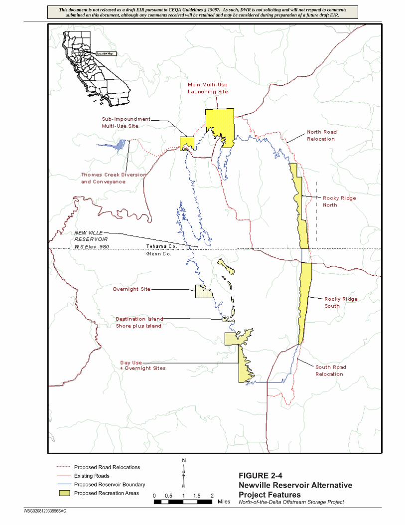
WBG020812033556SAC
0 2Miles
0.5 1 1.5
NProposed Road RelocationsExisting RoadsProposed Reservoir BoundaryProposed Recreation Areas
FIGURE 2-4Newville Reservoir Alternative Project FeaturesNorth-of-the-Delta Offstream Storage Project
This document is not released as a draft EIR pursuant to CEQA Guidelines § 15087. As such, DWR is not soliciting and will not respond to commentssubmitted on this document, although any comments received will be retained and may be considered during preparation of a future draft EIR.

FIGURE 2-5Newville Reservoir Alternative Project FeaturesNorth-of-the-Delta Offstream Storage Project
WBG020812033556SAC
0 2Miles
0.5 1 1.5
NProposed Road RelocationsExisting RoadsProposed Reservoir BoundaryProposed Conveyance Routes
This document is not released as a draft EIR pursuant to CEQA Guidelines § 15087. As such, DWR is not soliciting and will not respond to commentssubmitted on this document, although any comments received will be retained and may be considered during preparation of a future draft EIR.

WBG020812033556SAC
0 2Miles
0.5 1 1.5
N
Proposed Conveyance Routes FIGURE 2-6Newville Reservoir Alternative Project FeaturesNorth-of-the-Delta Offstream Storage Project
This document is not released as a draft EIR pursuant to CEQA Guidelines § 15087. As such, DWR is not soliciting and will not respond to commentssubmitted on this document, although any comments received will be retained and may be considered during preparation of a future draft EIR.

WBG020812033556SAC
0 2Miles
0.5 1 1.5
N
Proposed Conveyance RoutesFIGURE 2-7Newville Reservoir Alternative Project FeaturesNorth-of-the-Delta Offstream Storage Project
This document is not released as a draft EIR pursuant to CEQA Guidelines § 15087. As such, DWR is not soliciting and will not respond to commentssubmitted on this document, although any comments received will be retained and may be considered during preparation of a future draft EIR.

Black Butte Reservoir
Proposed Sites Reservoir
Red Bluff Pumping Plant at
Mill Site
T-C CanalConveyance Sizes
2,100 cfs (existing capacity)2,700 cfs4,000 cfs5,000 cfs
GCID CanalConveyance Sizes
1,800 cfs (existing capacity)3,000 cfs4,000 cfs5,000 cfs
ProposedDelevan Pipeline
Conveyance Sizes1,500 cfs2,000 cfs3,000 cfs4,000 cfs5,000 cfs
Proposed Colusa Basin PipelineConveyance Sizes
1,000 cfs3,000 cfs
ProposedStony Creek Pipeline
Conveyance Sizes1,000 cfs2,100 cfs
Proposed Sites Pumping Plant
0.6
38.5
40.0
2.713.2
10.6
8.0
Existing Funks Reservoir/Proposed Holthouse ReservoirLegend
Typical Direction of Flow
Note: Canal lengths are provided in miles.cfs = cubic feet per second
T-C = Tehama-ColusaGCID = Glenn-Colusa Irrigation DistrictTRR = Terminal Regulating Reservoir
GCID Pumping Plant
Proposed TRR and Pumping Plant
Proposed Sacramento River
Pumping Plant
Proposed Colusa Basin Pumping Plant
FIGURE 2-8Potential Conveyance Alternatives for Sites ReservoirNorth-of-the-Delta Offstream Storage Project
WBG020812033556SAC
This document is not released as a draft EIR pursuant to CEQA Guidelines § 15087. As such, DWR is not soliciting and will not respond to commentssubmitted on this document, although any comments received will be retained and may be considered during preparation of a future draft EIR.