


Languages
Pages
Legal


State of Washington ALBERT D. ROSELLINI, Governor
Department of Conservation and Development EARL COE, Director
DIVISION OF MINES AND GEOLOGY SHELDON L. GLOVER, Supervisor
Information Circular No. 26
URANIUM IN WASHINGTON
An Extract from
Bulletin 37, Inventory of Washington Minerals,
Part II, Metallic Minerals
By
MARSHALL T. HUNTTING
STATE PRINTING PLANT ~ OLYMPIA, WASH., 1957

URANIUM IN WASHING TON
BY MARSHALL T. HuNTTING
INTRODUCTION
This list of occurrences of uranium in Washington is extracted with only minor changes from the uranium section of Washington Division of Mines and Geology Bulletin 37, Inventory of Washington Minerals, Part II, Metallic Minerals, pages 350 to 357. It is printed separately and distributed without charge for the convenience of those readers who are interested in uranium but would not be sufficiently interested in the minerals of the other metallic elements to wish to purchase the larger bulletin.
The bibliography on page 10 is extracted from the list used in Bulletin 37, Part II. Each reference, here, is assigned a number in bold face type, but these numbers in the bibliography of the present report are not consecutive because only those references pertaining to uranium have been taken from the complete list used in Bulletin 37.
av.-average, averaged, averaging
Ave.-Avenue Co.-Company · cor.-corner Corp.-Corporation Cr.-Creek Dev-development dist.-district Div.-Division E.-east Elev-elevation est.-estimated Fk.-Fork ft.-foot, feet in.-inch, inches
ABBREVIATIONS
Inc.-Incorporated Lk., lk.-Lake, lake Loe-location max.-maximum mi.-mile, miles min.-minimum Mt.-Mount Mtn., Mtns.-Mountain,
Mountains N.-north NE.-northeast no.-number NW.-northwest 0-oxygen Ore min-ore mineral(s) p.-page
%-percent Prod-production Prop-property R.-River, Range Ref-references S.-south SE.-southeast sec.-section sq.-square SW.-southwest U-uranium vol.-volume W.-west W ash.-Washington yr.----:-year, years

2 Uranium in Washington
URANIUM
Properties-Uranium is a metal that is hard but ductile and malleable. It is very heavy (21/2 times as heavy as steel) and is capable of taking a high polish. The polished metal, however, rather quickly oxidizes to a black surface. In powder form uranium is black and pyrophoric, catching on fire spontaneously upon exposure to air. In its chemical behavior it is most closely related to chromium. The chemical symbol for uranium is "U." Its atomic number is 92, and its atomic weight is 238.07. The specific gravity of the element is 19.05 (1,166 pounds per cubic foot). Its melting point is 1133° C., and its boiling point is 2071 ° C. Uranium is radioactive, and the isotope U 235
(present in natural uranium to the extent of about 0.7 percent), is fissionable-properties of utmost importance. Uranium radiates alpha rays, and in its atomic disintegration produces a series of elements including helium, radium, actinium, and lead, which emit alpha, beta, and gamma rays. Pound for pound, fissionable uranium has more than two and a half million times the heat-producing energy of coal.
Uses-By far the most important use of uranium is as a source of nuclear energy, which is utilized in the atomic bombs, and which is being developed for use in power plants for various military and industrial applications. N onenergy uses of uranium in recent years have been largely in the chemical industries, including use as catalysts and in analytical reagents. Next in importance has been its use in ceramics-in glass for a coloring agent and to regulate the coefficient of thermal expansion of the glass. It has been used in motion picture film manufacture, in electrical equipment, and luminous paint, and it has been alloyed with steel for special uses.
Production-During the years 1945 through 1950 the United States consumption of uranium for nonenergy purposes varied between 1112 and 2112 tons per year. The amount used in the atomic energy program has not been announced. Prior to World War II most of our uranium was imported, but domestic sources now produce large quantities. Data on production and imports and exports are not disclosed. Every producer of uranium ore must be licensed by the U. S. Atomic Energy Commission, and the ore must be sold either directly to the Commission or to a buyer licensed by it.
Prices-Uranium salts prices have not changed greatly in the past few years. Sodium uranate sold at $1.25 per pound in 1936, $1.75 in 1939, and $1.65 from 1942 to 1948. Uranium metal prices have risen consideraply, however, being quoted at $7.00 per pound in 1943, $20.00 in 1946, and $50.00 per pound for high-purity metal in 1950. The Atomic Energy Commission's domestic uranium program provides for: (1) A guaranteed minimum price, effective through March 31, 1962, of $3.50 per pound f.o.b. shipping point, for uranium oxide (U ~08 ) contained in domestic ores or mechanical concentrates assaying at least 10 percent U 30 8 • This price does not apply to the carnotitetype and roscoelite-type ores of the Colorado Plateau. (2) Guaranteed minimum prices, effective through March
31, 1962, for the carnotite-type and roscoelite-type ores of the Colorado Plateau area, varying from $1.50 per pound of U30 8 in ores containing 0.10 percent U 30 8 to $3.50 per pound of U 30 8 in ores containing 0.20 percent or more U3 0 8 • (3) A bonus of $10,000, effective until April 11, 1958, for the discovery of a new deposit and the production therefrom of the first 20 short tons of uranium ore or mechanical concentrate assaying 20 percent or more U 30 8 •
(4) The Commission will pay an additional graduated bonus of up to $35,000, depending upon the quantity and grade of ore, for initial production and delivery of acceptable uranium ore from new and certain existing mining properties. For new properties this bonus payment will be made on each pound of uranium oxide up to and including the first 10,000 pounds.
In May 1956 the Atomic Energy Commission announced a new domestic procurement program which will cover the period from April 1, 1962, through December 31, 1966. This program provides a guaranteed market for uranium concentrates produced by domestic mills from domestic ores. The base price established under this program will be $8.00 per pound of U 30 8 contained in concentrates meeting specifications.
Ore minerals-More than 100 uranium-bearing minerals are known. In some of these uranium is the principal constituent, but in others it is only a minor part of the mineral. The more important primary minerals are the oxides, pitchblende (50 to 80 percent U 30 8 ) and uraninite (65 to 90 percent U 30 8 ). Some of the more common secondary uranium minerals are the potassium uranium vanadate, carnotite (50 to 55 percent U Ps); the calcium uranium phosphate, autunite (60 percent U 30 8); the copper uranium phosphate, torbernite (60 percent U 30 8 ); the calcium uranium vanadate, tyuyamunite, ( 48 to 55 percent U30 8 ); and the calcium uranium silicate, uranophane (65 percent U 30 8 ). In general, uranium occurs combined as oxides, phosphates, sulfates, arsenates, carbonates, vanadates, silicates, and hydrocarbons. Uranium minerals that have been found in Washington include uraninite, pitchblende, brannerite, autunite, torbernite, uranophane, monazite, and allanite. The latter two minerals are primarily thorium bearing but sometimes contain uranium. Other uranium minerals reported in Washington are zeunerite, fergusonite, samarskite, euxenite, and cyrtolite.
Geology-Uranium ore deposits occur in a great variety of rocks of igneous, metamorphic, and sedimentary origin. Primary deposits in hydrothermal veins appear to favor felsic intrusive rocks and arenaceous metasediments as host rocks. Within the veins, associated minerals contain, in decreasing order of abundance, iron, copper, cobalt, lead, silver, nickel, and bismuth. Of these, perhaps cobalt, nickel, and bismuth are most indicative. Pegmatites commonly contain uranium minerals but almost never in commercial quantities. The potassium-rich pegmatites, or zones in them, have been indicated as most favorable for the occurrence of uranium minerals. The secondary uranium-mineral occurrences, as low-grade disseminations in the sedimentary rocks-sandstone, shale,
Uranium in Washington 3
and limestone, are currently producing large tonnages of ore in the United States. A very large part of the domestic production comes from sedimentary-type deposits of this kind, largely from the Colorado Plateau in the "four corners" region of Colorado, Utah, Arizona, and New Mexico.
Although fairly large areas in Washington are underlain by Mesozoic and Tertiary continental sedimentary rocks, and some of these areas are being prospected, no sedimentary-type deposits in which carnotite commonly occurs have yet been found here. All the verified occurrences of uranium in Washington are either in granitic rock or in metamorphic rocks intruded by granite. Uraninite and secondary uranium minerals have been found in pegmatite dikes in this state but not in commercial quantities. The more promising uranium deposits in Washington have been found (1) in and near the contact of granite and rock the granite intrudes, (2) in shear zones cutting these rock types, and (3) as secondary minerals impregnating the fractured, decomposed, and disintegrated granitic and metamorphic rocks adjacent to contacts and shear zones. In other words, primary uranium mineralization may be expected to occur under much the same conditions as does copper, gold, silver, lead, zinc, molybdenum, and other ore mineralization.
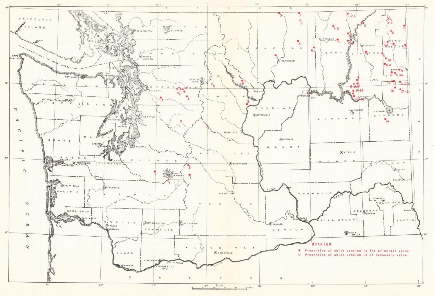
Recent developments-Uranium prospecting and exploration in Washington expanded very rapidly during the first few months of 1955, especially in Stevens and
Spokane Counties. This activity was the direct result of the discovery of substantial quantities of uranium ore at the Midnite Mines property on the Spokane Indian Reservation in southern Stevens County. Many large and small mining companies and thousands of individuals staked claims on open Federal land or obtained mineral leases on State and private lands north of the Reservation throughout Stevens County. Similar exploration activity in the vicinity of Mount Spokane was triggered by the announcement of the discovery of good-grade autunite mineralization on the Dahl farm near Elk in northern Spokane County. Exploration has been active in the whole northern row of counties westward from the Idaho boundary to the western flanks of the Cascade Mountains and in the Cascades about as far south as Mount Rainier. Locations showing radioactivity are known or have been reported in at least 10 counties in this general region, and this area includes all the authenticated uranium occurrences in Washington; however, because of the tremendous interest in uranium prospecting, there probably is no county in the state in which some prospecting has not been done. To date (February 1957) uranium ore has been shipped in quantities of more than 1 carload each from five properties in Washington, all in Stevens and Spokane Counties. These are the Midnite mine, originally operated by Midnite Mines, Inc. and later by Dawn Mining Co.; the Dahl, Lawley, and Huffman properties operated by Daybreak Uranium, Inc.; and the Lehmbecker property operated by North Star Uranium, Inc.
OCCURRENCES
Because serious prospecting for uranium in Washington started only very recently and new discoveries of radioactivity are being reported each week, it is impossible to include all the uranium occurrences in the following list. Any such list would be incomplete a short time after compilation.
CHELAN COUNTY Holden (Howe Sound) (1)
Loe: Secs. 18 and 19, (31-17E), and secs. 12 and 13, (31-16E), on Railroad Cr. Ore: Copper, gold, zinc, silver. Deposit: Zone of sulfide disseminations 20 to 75 ft. wide has exposed length of 2,500 ft. and depth of 2,500 ft. in metamorphic rocks. Slight amount of radioactive mineralization in footwall zone in W. end of mine at 1,950- and 2,325-ft. levels. Ref: 175. Details other than those dealing with uranium are described more fully in Washington Div. Mines and Geology Bull. 37, Pt. II.
Howe Sound (see Holden)
Keefer Brothers (2) Loe: On W. slope of Red Mtn., near headwaters of Chiwawa
R., about 1 mi. S. of Lyman Glacier. Ore: Molybdenum, copper, gold, silver, tungsten, uranium. Deposit: Narrow fissure veins with some hydrothermal alteration of the granodiorite wall rock. A channel sample taken at the most radioactive spot known on the veins assayed 0.1 % U,Os. Ref: 156. Details other than those dealing with uranium are described more fully in Washington Div. Mines and Geology Bull. 37, Pt. II.
Peshastin Loe: 12 mi. from Peshastin. Owner: R. F. Brown (1897).
Ore: Uranium, but the occurrence has not been authenticated. Ore min: "Probably a silicate." Deposit: 5-ft. ledge. Ref: 105, 10/16/97, p. 359.
Safety Harbor Creek ( 4) Loe: Safety Harbor Cr. area. Access: Trail. Prop: 6 claims.
Owner: Western.States Uranium, Inc. (1955--). Ore: Uranium. Ref: 158.
Winesap Canyon (3) Loe: SW1/4NW1/4 sec. 5, (26-21E), near head of Winesap
Canyon (Oklahoma Gulch). Access: 5 mi. by road to railroad. Prop: 1 unpatented claim. Owner: George Goman, Winesap, Wash. (1942). Ore: Uranium. Ore min: Uraninite. Deposit: Pegmatite made up of feldspar, quartz, and muscovite, with very minor amount of uraninite. Dev: Open cut 4 ft. by 6 ft. Ref: 67, p. 53. 158.
FERRY COUNTY Box Canyon (5)
Loe: Sec. 28, (37-37E), Nancy Cr. area. Owner: V. L. Stevens, Colville, Wash. (1955). Ore: Uranium. Deposit: Autunite in pegmatitic gneiss. Ref: 158.
Hurrell (8) Loe: Sec. 21, (36-37E), on SE. flank of Bisbee Mtn., w. of
Kettle Falls. Owner: John Hurrell, Inchelium, Wash. (1955). Ore: Uranium (?). Deposit: Radioactivity in pegmatite. Ref: 158.

4 Uranium in Washington
Lucky Leslie ( 1) Loe: Near center Wl/zNWl/4 sec. 23, (38-34E), on N. side of
Mt. Leona. Elev: 5,950 ft. Access: 11/z mi. by trail to N. Fk. St. Peters Cr. road, by which it is 71/z mi. to railroad at Malo. Prop: Lucky Leslie No. 2 and several other unpatented claims. Owner: Wm. Alexander and Chas. Bilderback, Sweet Home, Oreg. (1955). Ore: Uranium. Deposit: Uraninite and uranophane in irregular pegmatite lens 25 ft. long and up to 5 ft. thick along a shear zone that is parallel to schistosity in biotite schist and quartzite. Dev: Shallow open cut. Assays: Radiometric tests on samples from open cut show 0.35 % to 1.40 % U,O, equivalent. Ref: 158.
Lucky 21 (2) Loe: Near center NWl/4NEl/4 sec. 15, (38-34E), E. of Malo,
on St. Peters Cr. Elev: 3,750 ft. Access: 7 mi. by road to railroad at Malo. Prop: 10 unpatented claims, including Lucky 21. Owner: Bert Edwards, Doug Elmes, Malo, Wash., and William B. Kleinhans, Republic, Wash. (1955). Ore: Uranium. Deposit: Uraninite and uranophane in narrow pegmatitic lenses in quartzite and schist. Dev: Open cuts. Assays: 0.325% U,O, reported. Note: Since the original 8 claims were staked, 30 or more claims were staked nearby in a few days by various people. Ref: 158.
Nancy Creek (6) Loe: SW%SW% sec. 29, (37-37E), near Nancy Cr. Access:
21/z mi. by road to railroad. Prop: 8 claims and 120 acres deeded land. Owner: Patrick Sullivan and Darrell Newland, Colville, Wash., hold lease and have subleased to Day Mines, Inc., Wallace, Idaho (1955--). Ore: Uranium. Deposit: TJraninite and uranophane in pegmatitic lenses in gneiss. Assays: 0.31 % to 1.45% U,Os reported. Note: Since the original discovery in this area dozens of claims were staked within a short time. Ref: 158.
Oregonian (3) Loe: Wl/2 NW%SW% sec. 14 and El/zNEl/4SEl/4 sec. 15, (38-
34E), S. of St. Peters Cr. Access: l/2 mi. by trail to N. Fk. St. Peters Cr. road, by which it is 71/z mi. to railroad at Malo. Prop: Oregonian and several other unpatented claims. Owner: Art Cooper, Sweet Home, Oreg., and Ben Butler, Republic, Wash. (1955). Ore: Uranium. Deposit: Sparse uranophane in 50-ft. by 50-ft. outcrop of pegmatitic granite in biotite schist. Ref: 158.
Section 36 (7) Loe: Sec. 36, (37-36E), near head of Nancy Cr. Access:
About 8 mi. by road to railroad. Owner: Leases on 320 acres of State land held by R. C. Mulligan, R. J. Pulley, M. F. Fowler, and T. Jones, Okanogan, Wash. (1955). Ore: Uranium. Deposit: Pegmatitic granite in gneiss contains uranophane, autunite, and a little heavy black uranium mineral that probably is U:raninite; also hyalite, garnet, and apatite. Assays: Samples reported to run as high as 0.51 % U,O,. Ref: 158.
Sherman Creek Pass ( 4) Loe: Vicinity of Sherman Cr. Pass, Columbia Mtn., and
Sherman Pk., 17 mi. E. of Republic. Elev: 4,000 to 7,000 ft. Access: About 16 mi. by road to railroad at Republic. Prop: 29 or more claims. Owner: Sherman Creek Uranium Mines, Inc., Burl Fowler, A. J. Lane, R. R. Embody, Republic, Wash. (1954--). Ore: Uranium. Ore min: Monazite, autunite. Deposit: Weak radioactivity is sporadically distributed over large area near contact of granite with gneiss and schist, and local areas show considerable radioactivity. At least part of the radioactivity is concentrated in biotite-rich pegmatitic segrega-
. tions, and here the radioactivity· is ·due to the presence of monazite. Small amount of autunite has been reported along joints in talus blocks. Dev: Open cuts, diamond drill holes.
Assays: "Surface samples indicated up to 0.14% U,O,." Note: Since the original discovery hundreds of claims have been staked in this area. Ref: 158.
Sunset Mines (9) Loe: About 4 mi. W. of Kettle Falls. Prop: 7 claims. Owner:
Sunset Mines, Inc. (1955--). Ore: Uranium. Deposit: Finely divided uranium mineral (uraninite ?) in biotite gneiss. Assays: Some samples ran as high as 0.4% U,O,. Ref: 158.
GRANT COUNTY Grand Coulee (1)
Loe: 5 mi. S. of Electric City on road to Coulee City. Ore: Uranium. Deposit: Polycrase in pegmatite. Ref: 158.
Peterson Loe: Grand Coulee Dam area, possibly in Grant County.
Owner: Ben I. Peterson, Moses Lake, Wash. (1954-). Ore: Uranium. Ore min: Uraninite, brannerite. Allanite, euxenite, and cyrtolite reported. Deposit: Radioactive minerals in pegmatitic granite. Assays: 0.06% UaO, by radiometric analysis. Ref: 158:
KING COUNTY Rainy (Western States Copper) (1)
Loe: Sec. 16, (24-lOE), Taylor R. dist. Ore: Copper, gold, silver. Ore min: Chalcopyrite, pyrite, pyrrhotite, molybdenite. An insignificant amount of brannerite has been reported. Ref: 157. Details other than those dealing with uranium are described more fully in Washington Div. Mines and Geology Bull. 37, Pt. II.
Snoqualmie Loe: Near Snoqualmie Pass, in eastern King County. Ore:
Thorium, cerium, uranium (?). Deposit: A little allanite occurs as an accessory mineral in the Snoqualmie granodiorite. Ref: 146, p. 9.
Western States Copper (see Rainy)
KITTITAS COUNTY Big Dome (1)
Loe: Sec. 17, (23-15E) and sec. 13, (23-14E), on Fortune Cr. Ore: Copper, tungsten, reportedly uranium. Deposit: Irregular zones of chalcopyrite and pyrite disseminated in granodiorite. Only trace amounts of radioactivity. Ref: 158. Details other than those dealing with uranium are described more fully in Washington Div. Mines and Geology Bull. 37, Pt. II.
LEWIS COUNTY Eagle Peak (1)
Loe: Near NW. cor. sec. 27, (15-8E), on W. slope of Eagle Peak, Mt. Rainier area. Ore: Copper, gold, silver. Slight radioactivity reported near portal of upper drift. Ref: 157. Details other than those dealing with uranium are described more fully in Washington Div. Mines and Geology Bull. 37, Pt. II.
LINCOLN COUNTY Egypt
(see Pitney Butte)
Germania Consolidated Loe: 1 7 mi. N. of Davenport. Prop: 1,600 acres leased by
Germania Consolidated Mines, Inc., Spokane, Wash. (1955--). Ore: Uranium (?). Deposit: "Uranium indications" found. Dev: Drill holes. Ref: 158.

Uranium in Washington 5
Pitney Butte (Egypt, Spokane Molybdenum) (1) Loe: NEl/4SEl/4 sec. 32, (28-37E), on NE. side of Pitney
Butte. Ore: Molybdenum, gold, silver. Deposit: Molybdenite is scattered through a 3- to 4-ft. quartz vein in granite. A crossfracture contains a black radioactive lens 4 in. or more thick. Ref: 82-A. 133-B, p. 32. Details other than those dealing with uranium are described more fully in Washington Div. Mines and Geology Bull. 37, Pt. II.
Spokane Molybdenum (see Pitney Butte)
OKANOGAN COUNTY Aeneas (3)
Loe: NWl/4 sec. 15, (36-29E), on S. side of Aeneas Valley. Access: 19 mi. by road to railroad at Tonasket. Prop: Deeded land. Owner: Ted Eberle, Tonasket, Wash. (1955). Ore: Uranium. Deposit: Slight radioactivity along pegmatitic bands in gneiss. Assays: One sample showed 0.18% U,Os. Ref: 158.
American Strategic Minerals (5) Loe: Sec. 9, (40-26E), on N. slope of Elemeham Mtn., S. of
Similkameen R. Prop: Unpatented claims. Owner: American Strategic Minerals Corp., Tonasket, Wash. (1955). Ore: Uranium (?). Deposit: Radioactive black magnetic mineral in metamorphic rock. Ref: 158.
Bi-Metallic (2) Loe: NWl/4 sec. 26, (39-29E), near Havillah. Ore: Molyb
denum, copper, silver, gold, tungsten. Deposit: Molybdenite in zone 1 to 5 ft. wide and 50 ft. long in fractures and intersecting faults in Moly adit. Also ore in 2 other fault zones in Moly adit. Slight radioactivity (up to 4 times background count) in ore zones. Ref: 158. Details other than those dealing with uranium are described more fully in Washington Div. Mines and Geology Bull. 37, Pt. II.
Happy Hill (4) Loe: 4 mi. NW. of Okanogan, on Happy Hill. Probably in
SEl/4 sec. 14, (34-25E). Prop: 15 claims and some leased land. Owner: Sherman Creek Uranium Mines, Inc., Republic, Wash. (1955--). Ore: Uranium, thorium, cerium. Ore min: Monazite. Dev: Bulldozer trenches. Assays: As high as 5% monazite, with 21/2% to 3% rare earths content and 0.06% to 0.08% U,Os. Ref: 158.
Lost.Lake (1) Loe: Near Lost Lake, along the international boundary at
Molson. Owner: Barney Quinn (1925). Ore: Uranium, gold, and silver reported. Assays: Reported to show $84 per ton in uranium, $6 in silver, and $4 in gold. Ref: 106, 5/16/25, p. 25.
Sanpoil (6) Loe: Sec. 25, (35-31E), on upper part of Sanpoil R. Prop:
Unpatented claims. Owner: Albert Allen (1956). Ore: Uranium. Deposit: Pegmatite containing scattered tiny grains of samarskite and -radioactive violet-colored fluorite. Assays: Specimens reported to show max. of 0·.3% U,O •. Ref: 158.
PEND OREILLE COUNTY Bella May (Metaline Mining and Leasing Co.) (3)
Loe: NEl/4NEl/4 sec. 32, (39-43E), Metaline dist. Ore: Zinc, lead. Deposit: Replacement bodies containing sphalerite and galena in Metaline limestone. Unrelated uranium mineralization, of no apparent value, occurs as thin white to yellow coatings along fault surfaces. Ref: 156. Details other than those dealing with uranium are described more fully in Washington Div. Mines and Geology Bull. 37, Pt. II.
Dry Canyon (6) Loe: In Dry Canyon, which is 2 to 3 mi. E. of Pend Oreille R.
Deposit: A 4-ft. dike contains allanite as platy crystals as much as 112 in. long. Ref: 128, p. 58.
Golden Anchor (7A) Loe: 9 mi. W. of Usk. Prop: 6 unpatented claims. Owner:
Golden Anchor Mining and Milling Co., Spokane, Wash., leasing from George L. and Lloyd Howard, Spokane, Wash. (1955--). Ore: Uranium. Deposit: Autunite in pegmatite. Dev: Shallow pits. Ref: 158.
Grandview mine (2) Loe: Secs. 14, 15, 22, and 30, (39-43E), Metaline dist.
Ore: Zinc, lead. Deposit: Irregular replacements and disseminations of zinc-lead ore in dolomite. The uranium mineralization is noncommercial and appears to be unrelated to the zinc-lead ore. It occurs in black carbonaceous seams about 1 in. thick, in thin fault gouge zones, and as yellow secondary minerals depositing from descending ground waters. Ref: 156. Details other than those dealing with uranium are described more fully in Washington Div. Mines and Geology Bull. 37, Pt. II.
Highnoon Uranium (8) (see also Rocky Ridge and West) Loe: Lost Creek area. Prop: 10 claims and leases on 1,500
acres of land. Owner: Highnoon Uranium Mines, Inc., % J. R. Jones, Newport, Wash. (1955--). Ore: Uranium. Deposit: Small deposit of high-grade ore. Ref: 158.
Josephine (Pend Oreille Mines & Metals Co.) (1) Loe: Sl/2 sec. 16, (39-43E), on W. side of Pend Oreille R.,
Metaline dist. Deposit: Similar to that at Grandview mine. Ref: 156. Details other than those dealing with uranium are described more fully in Washington Div. Mines and Geology Bull. 37, Pt. II.
Kimball Mines ( 9) Loe: 7 mi. W. of Newport, 2 mi. W. of Diamond Lk., on
Bert Smith farm. Prop: Mineral rights lease on 282 acres of deeded land. Owner: Kimball Mines, Inc., Spokane, Wash., leasing from Bert Smith, Newport, Wash. (1955--). Ore: Uranium (?). Deposit: Higher-than-normal radioactivity in old prospect hole in decomposed granite. Ref: 158.
Metaline Mining and Leasing Co. (4) (see Bella May)
Pend Oreille Mines & Metals Co. (see Josephine)
Ponsness (10) Loe: Secs. 18 and 19 (?), (35-46E), near Idaho boundary,
N. of Newport. Owner: Lloyd Ponsness, Newport, Wash. (1955). Ore: Uranium. Deposit: Autunite in weathered granite. Ref: 158.
Rocky Ridge (6A) Loe: On Ruby Cr., W: of Blue Slide. Prop: Unpatented
claims. Owner: Highnoon Uranium Mines, Inc., Newport, Wash. (1955--). Ore: Uranium. Deposit: Commercial-grade ore reported. Ref: 158.
Ruby (7) Loe: Sec. 6, (34-44E), near Ruby. Owner: Lewis E. De
Chenne, Cusick, Wash. (1955). Ore: Uranium. Ore min: Uraninite, autunite. Deposit: Pegmatite containing smoky quartz, albite, muscovite mica, a little apatite, and a few ·tiny garnet crystals; also has a few scattered grains of uraninite altered in part to autunite. Ref: 158.

6 Uranium in Washington
Sacheen Lake (5) Loe: Probably sec. 30 (or possibly sec. 29 or 32), (31-44E),
on top of hill just E. of Sacheen Lk. Owner: Forrest Corwin, E. 1624 Liberty Ave., Spokane, Wash. (1939). Ore: Uranium (?). Deposit: A sample of pegmatitic granite composed of quartz, orthoclase, and a very little magnetite showed slight radioactivity in one very restricted area of the specimen. Ref: 158.
South Skookum Lake Loe: About 1h mi. E. of South Skookum Lk., probably in sec.
6, (33-45E). Prop: 21 claims. Owner: Silver Dollar Mining Co., Spokane, Wash. (1955). Ore: Uranium. Deposit: Autunite in shear zone in granite. Dev: Bulldozer cuts. Assays: Channel sample across 3-ft. width showed 0.74% U,Os. Ref: 158.
Stagger Inn (11) Loe: Near Stagger Inn Ranger Station. Prop: 6 unpatented
claims. Owner: Northwest Prospecting and Development Co., Spokane, Wash. (1955). Ore: Uranium (?). Deposit: Radioactivity along granite-argillite contact. Ref: 158.
Starlight Uranium (8A) Loe: Sec. 10, (32-42E), near Calispell Cr. Prop: 8 unpatented
claims. Owner: Starlight Uranium Co., Frank Gibson, Deer Park, Wash. (1955). Ore: Uranium. Dep0sit: Autunite disseminated in rotten granite across a width of 30 ft. Ref: 158.
West (5A) Loe: Near Diamond Lk. Owner: Highnoon Uranium Mines,
Inc., Newport, Wash. (1955--). Ore: Uranium. Deposit: Commercial-grade ore reported. Ref: 158.
PIERCE COUNTY Rushing River ( 1)
Loe: On Rushing R. (or Rushingwater Cr. ?) on W. flank of Mt. Rainier. Prop: 38 unpatented claims. Owner: Al Nigro, Frank Stankevich, and J. L. Pennington, Tacoma, Wash. (1955). Ore: Uranium. Ore min: Pitchblende. Assays: Samples reported to run as high as 19.8% U,Os. Ref: 158.
SKAMANIA COUNTY 8,ainbow (1)
Loe: Center S1hS1h sec. 32, (3-5E), on ridge separating W. Fk. of Washougal R. from Wild Boy Cr. Deposit: Although uranium has been reported here associated with vanadium, lead, copper, gold, and silver, the report probably is in error. Ref: 104, vol. 14, no. 4, p. 40. Details other than those dealing with uranium are described more fully in Washington Div. Mines and Geology Bull. 37, Pt. II.
SNOHOMISH COUNTY Broken Ridge (5A)
Loe: S1h sec. 18, (28-llE), Silver Creek dist. Ore: Copper, silver, gold, zinc. Deposit: Silicified and mineralized shear zones in metamorphic rocks. Moderate radioactivity in one place on Dewey claim. Ref: 158. Details other than those dealing with uranium are described more fully in Washington Div. Mines and Geology Bull. 37, Pt. II.
Keller (5) Loe: Near Mineral City, probably in sec. 6, (28-llE). Access:
1 mi. by trail and about 15 mi. by road from railroad at Index. Prop: 8 unpatented claims. Owner: M. E. Keller, McKenna, Wash., and Harold Mykol, Olympia, Wash. (1955). Ore: Uranium. Deposit: Uraninite in quartz veinlets. Also some sandstone that is radioactive. Assays: Specimens run as high as 10 % U,Os. Ref: 158.
Kromona (4) Loe: Near center sec. 13, (28-9E), in Sultan Basin. Ore:
Copper, gold, silver, tungsten. Dep0sit: Sulfides in shear zone across the contact of quartz diorite and older metamorphic rocks. Ore in places is slightly radioactive. Ref: 158. Details other than those dealing with uranium are described more fully in Washington Div. Mines and Geology Bull. 37, Pt. II.
Mackinaw (1) Loe: SE%SW% sec. 19, (29-llE), on W. Fk. Weden Cr.
Ore: Copper, nickel, cobalt, gold, silver. Deposit: Sulfides and secondary minerals in shear zone at contact of serpentine and sedimentary rocks. Small areas of slight radioactivity in the shear zone. Ref: 158. Details other than those dealing with uranium are described more fully in Washington Div. Mines and Geology Bull. 37, Pt. II.
Molly (2) Loe: Sec. 30, (28-llE), near Galena Lookout Station. Approx.
9 mi. E. of Index on N. Fk. of Skykomish R. Owner: Wm. C. Duncan, Seattle, Wash. (1951). Ore: Uranium, molybdenum. Ore min: Molybdenite, uraninite, chalcopyrite. Ref: 157.
Sultan (3) Loe: 5 mi. W. of the town of Sultan. Owner: A. A. Kennedy.
Ore: Uranium. Ref: 1, 10/16, p. 110. 14, p. 50.
SPOKANE COUNTY Affiliated Mines (20)
Loe: On W. slope of Mt. Kit Carson. Prop: 620 acres of leased land. Owner: Affiliated Mines, Inc., Spokane, Wash. (1955--). Ore: Uranium. Ore min: Autunite. Dev: Diamond drill holes, bulldozer trenches. Ref: 158.
Anaconda Uranium (21) Loe: Lee lease: S1hSEl/4 sec. 23, (28-44E). Stanley lease:
NWl/4 sec. 6, (27-45E). Elev: 2,450 to 3,056 ft. Access: Roads. Prop: 240 acres of leased land. Owner: Anaconda Uranium Corp., Spokane, Wash. (1955--). Ore: Uranium. Deposit: Autunite and gummite reported in granite. Ref: 158.
Carbon (16) Loe: Sec. 7, (28-44E), Mt. Spokane area. Owner: Carbon
Mining & Uranium Co., Spokane, Wash. (1955--). Ore: Uranium. Ref: 158.
Columbia Enterprises (7) Loe: S%SE1/4 sec. 1, (28-44E), Mt. Spokane area. Access:
8 mi. by road to railroad at Elk. Prop: Several unpatented claims. Owner: Mt. Spokane Minerals & Uranium, Inc., Spokane, Wash., leasing to Columbia Enterprises Inc., Longview, Wash. ( 1955). Ownership of mineral rights on this property is currently (1955) in controversy. Ore: Uranium. Deposit: Coarse crystals of autunite along joints and irregular seams in altered pegmatitic granite. Radioactivity and float traceable for several hundred ft. Dev: Open pits. Assays: Picked sample ran 6.8% U,Os. Ref: 158.
Curtin (18) Loe: Wl/zNWl/4 sec. 24, (28-44E), Mt. Spokane area. Owner:
Oliver and Lillian Curtin leasing to Dawn Uranium & Oil Co., Spokane, Wash. (1955--). Ore: Uranium. Deposit: Autunite in granite. Dev: 4 out of 20 wagon-drill holes indicated commercial ore at depths of from 15 to 50 ft. Ref: 158.
Dahl (Daybreak) (1) Loe: El/zNEl/4 sec. 11, (28-44E), about 18 mi. NE. of Spokane,
in Mt. Spokane area. Elev: 2,800· ft. Access: 8 mi. by road to railroad at Elk and about 30 mi. to railroad at Spokane. Prop: 80 acres of deeded land. Owner: Alfred L. Dahl, Elk, Wash., leasing to Daybreak Uranium, Inc., Spokane, Wash. (1955--).

Uranium in Washington 7
Ore: Uranium. Deposit: Meta-autunite occurs as veinlets and fillings of closely spaced joints in decomposed granite. 5 ore bodies in an area 250 ft. by 900 ft., being worked by open pit. Dev: 7 diamond drill holes (July 1955) show ore to depth of at least 100 ft. 46,300 tons proven ore reserves reported. Assays: Channel samples across 35-ft. width showed 0.35% to 0.80% U,O,. First 10 carloads shipped av. 0.55% U,0,. Prod: Production began Aug. 1955. Total of 5,196 tons through Sept. 1956 av. 0.3346% U,O,. Also 7 carloads from nearby Huffman lease in Sept. 1956. Ref: 158.
Dahl Uranium Mine, Inc. (5) (see also under Stevens County)
Loe: SEl/4 sec. 1, (28-44E) and Nl/zSWl/4 and SW1/4SW1/4 sec. 6, (28-45E), 11/4 mi. NE. of original discovery on Dahl (Daybreak) uranium property, in western foothills of Mt. Spokane. Access: Road. Prop: Mineral rights on 141 acres of deeded land. Owner: Dahl Uranium Mine, Inc. leasing from Leonard A. and Betty C. Dahl, Spokane, Wash. (1955--). Ore: Uranium. Deposit: High-grade autunite ore reported exposed in 2 places more than 100 ft. apart. One drill hole showed ore mineralization from 22 ft. to 35 ft. deep, and a second hole about 340 ft. S. of the first showed ore at 35-ft. depth. A vein 21 in. wide, exposed for 17 ft., carries up to 2% U,O,. Prod: One carload shipped in 1956. Ref: 158.
Dawn Uranium & Oil (8) (see also Curtin, Smith)
Loe: El/z Wl/z sec. 8, (28-44E) and secs. 26 and 27, (29-44E), near Elk, about 2 mi. N. of Dahl property, Mt. Spokane area. Access: Road. Prop: More than 160 acres of leased land. Owner: Dawn Uranium & Oil Co., Spokane, Wash., leasing from R. E. Wisemore, Spokane, Wash., and H. B. Sams, Elk, Wash., and others (1955). Ore: Uranium. Deposit: Showings of autunite reported in shallow test pits in decomposed granite. At a depth of more than 300 ft. a diamond drill hole intersected 5 ft. of steeply dipping mineralized zone containing autunite. Autunite in 2 other widely spaced holes. Dev: Diamond drill holes in Sl/2SE1/4 sec. 27, (29-44E). Ref: 158.
Daybreak (see Dahl and see Bair, Lowley under Stevens County)
Elk Uranium (2) Loe: 1 mi. E. of Dahl property, and other places in Spokane
and Stevens Counties. Prop: Mineral rights on several thousand acres of deeded land. Owner: Elk Uranium, Inc., Spokane, Wash. (1955--). Ore: Uranium. Deposit: Radioactivity reported. Dev: Bulldozer trenches and diamond drill holes. Ref: 158.
Fish Lake (14) Loe: El/zSEl/4 sec. 32 and Wl/zSWl/4 sec. 33, (24-42E), just
N. of Fish Lk. Access: Paved highway crosses deposit, and railroad is within a few hundred ft. Prop: Deeded land. Ore: Uranium. Ore min: Secondary minerals. Deposit: Small irregular masses and veinlets of pegmatite near contact of granite with older metamorphic rocks. Although slight radioactivity may be detected in many places over an area of several thousand sq. ft., no concentrations of ore grade are known. Ref: 158.
Graham (15) Loe: Sec. 11, (29-44E), Mt. Spokane area. Prop: 160-acre
lease. Owner: Sidney Mining Co. and Mascot Mines, Kellogg, Idaho (1955--). Ore: Uranium. Deposit: Autunite found in 3 shallow pits. Ref: 158.
Huffman (see Dahl)
Kit Carson Uranium (3) Loe: Center SEl/4 sec. 13, (28-44E) and sec. 18, (28-45E),
S. of Dahl property. Elev: 3,350 ft. Access: Road. Prop: Leases on 600 acres of deeded land. Owner: Kit Carson Uranium, Inc., Spokane, Wash., leasing from R. B. Pulliam, Colbert, Wash. (1955--). Ore: Uranium. Deposit: Coarse autunite crystals are abundant in a 6-in. low-dipping shear zone in rotten pegmatitic granite. Ore zone 400 ft. long and 50 ft. wide reported. Two other ore bodies indicated. Ore mineralization found at depths of a few ft. to 156 ft. in about half of 52 holes drilled to depths of 50 to 156 ft. Ore from 42 to 90 ft. in one hole. Dev: Four 50-ft. bulldozer trenches. Ref: 158.
Miner (6) Loe: NEl/4 sec. 30, (29-45E), 3 mi. NE. of Dahl property, in
Mt. Spokane area. Access: About 8 mi. by road to railroad at Elk. Prop: 350 acres of deeded land. Owner: Dr. W. C. Miner, Opportunity, Wash. (1955). Ore: Uranium. Deposit: Radioactive ore reported to be in a zone 2 to 3 ft. wide exposed in road cut. Dev: Bulldozer cuts. Ref: 158.
Morning Sun Uranium ( 4) Loe: Adjacent to the Dahl property on the E., in Wl/zNWl/4
and Wl/zNEl/4 and Nl/zSEl/4 sec. 1, (28-44E) and NWl/4 sec. 7, (28-45E), Mt. Spokane area. Access: 8 mi. by road to railroad at Elk. Prop: 240 acres of State land in sec. 12, 160 acres l/2 mi. to the E., and 80 acres l/4 mi. to the NE. Owner: Daybreak Uranium, Inc., Spokane, Wash., has lease from A. L. Dahl, who is leasing from State (1955--). Ore: Uranium. Ore min: Meta-autunite. Gangue: Granite. Deposit: Ore mineralization reported to be similar to that at Dahl deposit. Dev: Bulldozer trenches. Ref: 158.
North Star Uranium Loe: Sec. 1, (28-44E), Mt. Spokane area. Prop: Lehmbecker
lease. Owner: Leased by North Star Uranium, Inc. (1956--). Ore: Uranium. Deposit: Autunite in granite exposed for 75-ft. length. Assays: 2 carloads shipped av. 0.225% U,O,. Prod: 2 carloads shipped in Dec. 1956 and Jan. 1957. Ref: 158.
Painted Desert (12) (see also under Stevens County) Loe: 2 mi. S. of Dahl property. Prop: Mineral leases on about
1,000 acres. Owner: Leased by Painted Desert Uranium and Oil Co., Spokane, Wash. (1955--). Ore: Uranium. Deposit: High-grade autunite in float reported. Some uranium in one hole at depth of 20 to 40 ft. Dev: Diamond drill holes. Ref: 158.
Schaefer (13) Loe: Secs. 19, 30, and 31, (29-44E) and secs. 24, 25, and 36,
(29-43E), near Milan. Access: Railroad crosses property. Prop: Mineral lease on several hundred acres of deeded land. Owner: Daybreak Uranium, Inc., Spokane, Wash., leasing from Everett and Irene Schaefer (1955). Ore: Uranium. Deposit: Good autunite crystals found at a depth of 7 ft. Ref: 158.
Section 32 (9) Loe: Sec. 32, (28-45E), near top of Mt. Spokane. Ore:
Uranium. Deposit: Autunite in granite. Ref: 158.
Section 21 (10) Loe: Sec. 21, (28-45E), near top of Mt. Spokane. Ore:
Uranium. Deposit: Autunite in granite. Ref: 158.
Smith (17) Loe: El/zSWl/4 sec. 13, (28-44E), Mt. Spokane area. Owner:
Emma L. and Clarence I. Smith leasing to Target Uranium Co.,

8 Uranium in Washington
which has made a 50-50 profit-sharing agreement with Dawn Uranium & Oil Co., Spokane, Wash. (1955--). Ore: Uranium. Deposit: Commercial ore found in 6 out of 10 wagon-drill holes. 6,650 tons of ore reported to a depth of 60 ft. Prod: At least 1 truckload in 1956. Ref: 158.
Stapleton (12A) Loe: El/2 sec. 1, (29-44E), Mt. Spokane area. Elev: 2,800 to
3,100 ft. Prop: 320 acres of leased land. Owner: National Uranium Corp., Wallace, Idaho, has 10-yr. lease (1955--). Ore: Uranium. Deposit: Autunite in shear zone in pegmatitic granite. Dev: Adit, 6 open cuts. Ref: 158.
Thompson (19) Loe: Sec. 18, (28-45E), on W. slope of Mt. Kit Carson. Prop:
200-acre lease. Owner: Leased by Tungsten Uranium Mines, Inc., Spokane, Wash. (1955--). Have profit-sharing agreement with Rayrock Uranium Co. Ore: Uranium (?). Deposit: Radioactive spring. Ref: 158.
Tungsten Uranium Mines (11) (see also Germania under Stevens County) Loe: Sec. 18, (28-45E), 1 mi. W. of Mt. Spokane State Park
and 4 mi. S. of Dahl property. Prop: Mineral leases on 323 acres of deeded land. Owner: Leased by Tungsten Uranium Mines, Inc., Spokane, Wash., from Arthur Selleck (1955). Ore: Uranium. Deposit: Autunite reported in granite. Dev: Bulldozer trenches. Ref: 158.
STEVENS COUNTY AA (1)
Loe: Sec. 26, ( 40-36E), Orient dist. Prop: 1 unpatented claim: A A No. 2. Owner: Berger Benson, Spokane, Wash. (1955). Ore: Uranium. Deposit: Autunite in pegmatitic gneiss. Ref: 158.
Arden (4) Loe: SE1/4SW1/4NW1/4 sec. 14, (34-39E), about 1 mi. SE. of
Arden. Elev: 1,875 ft. Owner: L. E. Haye, Lakeview, Wash. (1955--). Ore: Uranium. Deposit: Autunite sparsely distributed along a NE.-trending fractured zone for a length of 5 ft. in Loon Lake granite. Zone of fracturing and clay-mineral alteration is about 2 ft. wide. Considerable fluorescent hyalite in the vicinity. Ref: 158.
Bair (14) Loe: El/2 sec. 14, (27-37E), near Spokane R., on Spokane
Indian Reservation. Owner: Daybreak Uranium, Inc., Spokane, Wash., has assignment of prospecting lease held by Mr. Bair from Spokane Indian Tribe (1955--). Ore: Uranium. Ore min: Autunite, uraninite. Assays: Sample from veinlets across a 30-ft. bulldozer cut showed 0.48% U,Os by chemical analysis. Ref: 158.
Big Smoke Uranium (18) Loe: Sec. 11, (27-37E), near Spokane R. Prop: The company
holds prospecting permits on more than 10,000 acres of Spokane Indian Reservation land. Owner: Big Smoke Uranium, Inc., Spokane, Wash. (1955--). Ore: Uranium. Ore min: Uraninite, gummite. Deposit: 2 veins in 30-ft. fault zone in arkose near contact with granite. Uraninite and gummite in coal in seam 8 ft. wide at depth of 14 ft. A second vein is 12 in. wide and is 30 ft. N. of the first. Dev: Bulldozer pit 12 ft. deep. Assays: Chemical assay of soil from 3-ft. depth showed 0.28% U,O,. A 2-ft. vein showed 0.50% U,O, equivalent, but chemical assay showed 1.30% U,O,. Prod: One carload shipped in 1956. Ref: 158.
Boyd (11) Loe: Adjoining Midnite mine on E. Prop: 458 acres of
Spokane Indian Reservation land allotted to Ed Boyd and other
members of the Boyd family. Owner: Leased by Dawn Mining Co., Portland, Oreg. (1956). Ore: Uranium. Deposit: Similar to adjacent Midnite deposit. Assays: 50 ft. of ore in drill hole av. 0.30% U,O,. Ref: 158.
Calispell Peak ( see Cannon)
Cannon (Calispell Peak, Railway Dike) (5) Loe: Near W. 1/4 cor. sec. 33, (34-42E), on headwaters of
Chewelah Cr. Elev: 3,750 to 4,340 ft. Access: About l/2 mi. by trail from the end of the road up Chewelah Cr. Prop: 1 claim. Owner: Merikay Mines, Laurence Hammond, New York, N. Y., leasing from Northern Pacific Ry. (1952). Earl and Perry Cannon, Chewelah, Wash. (1950). Ore: Uranium, columbium, tantalum, beryllium. Ore min: Columbite, uraninite, autunite, torbernite, beryl, a few specimens of bismutite. Gangue: Quartz, feldspar, muscovite. Deposit: Pegmatite dike in roof pendant of schist near intrusive granite. Pegmatite zone is 50 ft. wide and has a length of 1,050 ft. Only a few crystals of uraninite and columbite found. Dev: 2 open cuts, 8 trenches, 353-ft. adit. Assays: Uranium and columbium content below commercial grade. Prod: 6 tons of beryl in 1952. Ref: 158.
Crawford (see Indian Chief Uranium)
Dahl Uranium Mine, Inc. (12) (see also under Spokane County) Loe: Sec. 13, (28-37E), near Midnite mine. Owner: Dahl
Uranium Mine, Inc., Spokane, Wash. (1955--). Ore: Uranium. Deposit: Autunite near contact of granite with argillite. Dev: Several drill holes as much as 75 ft. deep showed weak radioactivity. One hole showed ore from the 128-ft. to 140-ft. depth. Assays: 0.20% to 0.70% U,O, equivalent from 128-ft. to 134-ft. depth in one hole. Ref: 158.
Germania (8) Loe: Near center SWl/4 sec. 13, (29-37E), Deer Trail dist.
Ore: Tungsten. Deposit: Wolframite in quartz veins 2 in. to 3 ft. wide in granite. Area of high radioactivity reported on property. Ref: 158. Details other than those dealing with uranium are described more fully in Washington Div. Mines and Geology Bull. 37, Pt. II.
Germania Consolidated (SA) Loe: Secs. 23, 24, and 26, (29-37E), Deer Trail dist. Ore:
Tungsten. Deposit: Wolframite in 3 narrow quartz veins in granite. Radioactivity reported on 128 acres of deeded land on N. border of company holdings. Ref: 158. Details other than those dealing with uranium are described more fully in Washington Div. Mines and Geology Bull. 37, Pt. II.
Indian Chief Uranium (Crawford) (7) Loe: Sec. 10, (29-37E) and Nl/2 sec. 8, (29-38E), about 7 mi.
N. of Midnite mine. Access: Roads. Prop: 22 unpatented claims. Owner: Indian Chief Uranium Co. leasing to Sidney Mining Co. and Mascot Mines Co., Kellogg, Idaho (1955--). Ore: Uranium. Deposit: Autunite reported in sec. 10, (29-37E) in a "tight" vein at a granite-quartzite contact. Exposed along the full length of a 30-ft. bulldozer trench that does not reach either end of the vein. Dev: 1,800 ft. of bulldozer trenching (May 1955). Ref: 158.
Lowley (17) Loe: Sl/z sec. 13, (27-37E), 7 mi. S. of Midnite mine. Prop:
320 acres. Owner: Daybreak Uranium, Inc., Spokane, Wash., has assignment of prospecting lease held by William Lowley, Wellpinit, Wash. (1955--). Ore: Uranium. Ore min: Uraninite, uranophane, autunite, and torbernite. Deposit: Faulted contact between granite and metasediments has uranium mineralization in small fracture seams throughout an area 100 ft. by 300 ft.
Uranium in Washington 9
Assay1,1: 50 lb. of samples across 70-ft. width reported to run 1.05% U30s. Prod: 5 carloads reported in 1956. Ref: 158.
Lucky Charm Uranium (10) Loe: Adjoins the Midnite uranium mine on the NE. In sec.
7, (28-38E), also secs. 23 and 26, (27-37E) and Sl/z sec. 23, (29-38E). Owner: Lucky Charm Uranium Mines., Inc., Spokane, Wash., holds prospecting permits on 5 sections of Spokane Indian Reservation land. Ore: Uranium. Deposit: "Good radioactivity." Autunite along joints in altered basalt in bulldozer cuts in Sl/2 sec. 23, (29-38E). Ref: 158.
Midnite (9) Loe: Secs. 1 and 12, (28-37E), on flanks of Lookout Mtn.,
10 mi. NW. of Wellpinit. Elev: 2,800 to 3,400 ft. Access: 33 mi. by road to railroad at Springdale or Reardan. Prop: 570-acre lease from Spokane Indian Agency. Owner: Midnite Mines, Inc., Clair Wynecoop, Pres., Wellpinit, Wash. (1954--) leasing to Dawn Mining Co., 503 Public Service Bldg., Portland, Oreg. (1955--). Ore: Uranium. Ore min: Autunite, uranophane, gummite, torbernite, uraninite, liebigite, phosphuranylite. Gangue: Altered rock. Dep0sit: Radioactivity traced more than 1 mi. N. and S. Uranium mineralization is in shear zones at and near intrusive contact of Loon Lake granite and Deer Trail argillite in a contact zone which is 100 to 200 ft. wide. Ore bodies, ranging up to several hundred ft. in length and 30 or more ft. in width, are richest at the center and grade outward to assay walls. Autunite and uranophane are the principal ore minerals, but uraninite was found with pyrite at a depth of 150 ft. in one core hole. Mineralization is strongest along joints in argillite but extends down into granite also. Est. 700,000 tons ore reserves reported in 1956. Dev: 13 diamond drill holes drilled by A.E.C. and 28,476 ft. of diamond drill holes drilled by Dawn Mining Co. Numerous bulldozer trenches, 540 ft. of adit workings (1955). Assays: One representative sample ran 0.48 % U,0,, and others ran as high as 0.86% U,0,. Av. of 709 tons shipped was 0.285% U:iOs. Prod: 100 tons of ore in 1954, 609 tons through Feb. 1955. 94 carloads of ore prior to end of Jan. 1956. Ref: 152-A. 158.
Northwest Uranium (15) Loe: On Spokane Indian Reservation, southern Stevens
County, 3 mi. S. of Midnite mine. Owner: Northwest Uranium Mines, Inc., Wallace, Idaho (1955--). Ore: Uranium. Ore min: Autunite. Deposit: Secondary uranium minerals in faults and lignite beds in flat-lying Tertiary claystone, sandstone, and conglomerate beds overlying granite. Dev: Trenches in an area 1,000 ft. by 600 ft. Assays: Sample across 20-ft. stratigraphic thickness of beds shows 0.13% U,O,. Selected samples from lignite show as high as 1.15% U,O, and av. 0.643%. A fault-breccia zone 3 ft. wide assays 0.237% U,O,. Chemical analysis of three 50-lb. samples showed: (1) bentonitic clay and carbonaceous material-0.427% U,O,, (2) arkose-7.16% U,O,, (3) conglomerate-0.128% U,O,. Radiometric analysis of these same samples showed only about half the above indicated values. Ref: 158.
O'Toole Mountain (3) Loe: Nl/2 sec. 9, (38-39E), on O'Toole Mtn., 12 mi. from
Bossburg. Elev: 3,500 ft. Access: Road. Prop: 2 claims: Mountain View No. 1, Urabar No. 1. Owner: V. J. Granfors, Seattle, Wash. (1953). Grutts and Mulligan (1903). Ore: Uranium reported, but one spectrographic analysis failed to show any uranium although the sample was radioactive. The
rare earth elements, scandium, yttrium, and ytterbium are present. Ore min: Pyrite, galena. Ref: 105, 2/03, p. 95.
Painted Desert (2A) (see also under Spokane County) Loe: Near Orient. Prop: 6 claims and options on 195 acres
of land. Owner: Painted Desert Uranium and Oil Co., Spokane, Wash. (1955--). Ore: Uranium. Assays: Samples reported from 0.30% to 1 % U,O,. Ref: 158.
Railway Dike (see Cannon)
Section 13 (16) Loe: Sec. 13, (27-37E); in Spokane Indian Reservation. Ore:
Uranium. Deposit: Uranophane in anthophyllite along contact. Ref: 158.
Snowshoe (6) Loe: Secs. 33 and 34, (30-38E). Prop: 10 unpatented claims.
Owner: American Silver Mining Co., Spokane, Wash., and Frontier Uranium, Inc., Seattle, Wash., jointly own the property (1955). Ore: Uranium (?). Deposit: Radioactivity reported. Ref: 158.
Square Deal (13) Loe: Sec. 13, (28-37E), adjacent to Midnite property. Owner:
Square Deal Mining & Milling Co., Wallace, Idaho, has agreement with Spokane Indian tribal members who hold prospecting permits on 640 acres (1955). Ore: Uranium. Deposit: U,O, values of about 0.1 % along granite-argillite contact. Ref: 158.
U & W Uranium (2) Loe: Leased land in Secs. 13, 14, 23, 24, 25, and 26, (40-36E),
Orient dist. Access: Road. Prop: Several hundred acres of leased land, 11 unpatented adjacent claims. Owner: U & W Uranium, Inc., Spokane, Wash., is leasing mineral rights from J. C. B. Graeber and others (1955). Ore: Uranium. Deposit: Uraninite in mica schist. Assays: One sample from center SEl/4 sec. 23, (40-36E) is reported to show 2.82% U,O,. Ref: 158.
YAKIMA COUNTY Bumping Lake (1)
Loe: In the valley of Deep Cr., near the mouth of Copper Cr., on the road to Copper City, 5 mi. S. of Bumping Lk. dam. Access: 5 mi. by gravel road and 11 mi. by paved road from Chinook Pass highway. 53 mi. by road from railroad at Naches. Prop: 6 unpatented claims, including El Khohbar No. 1. Owner: Tom Hendrix, Yakima, Wash. (1954--). Ore: Uranium. Deposit: Strong radioactivity in soil and gravel around a mineral spring which emerges from granite near contact with andesite. Also some autunite along joints in granite. Dev: Open pits. Assays: 0.88% U,O, by wet analysis and 0.36% U,O, by radiometric test on surficial soil. Note: Within a few days of the announcement of this original discovery more than 80 claims were staked by various people in an area about 21h mi. square in this vicinity. Ref: 158.
Chinook Pass (2) Loe: About 3 mi. E. of Chinook Pass, in western Yakima
County. Owner: Thomas Smith, Hainline, Wash. (1955--). Ore: Uranium reported. Ref: 158.

10 Uranium in Washington
BIBLIOGRAPHY 1. Alaska and Northwest Mining Journal; continued as Pacific
and Alaskan Review. 14. Broughton, W. A., Inventory of mineral properties in Snoho
mish County, Washington: Washington Div. Geology Rept. Inv. 6, 64 pp., 1942.
67. Huntting, M. T., Inventory of mineral properties in Chelan County, Washington: Washington Div. Geology Rept. Inv. 9, 63 pp., 1943.
82-A. King, R. U., Moore, F. B., and Hinrichs, E. N., Pitchblende deposits in the United States: U. S. Geol. Survey Circ. 220, pp. 8-9, 1952.
104 . Mining Journal. 105. Mining and Scientific Press. 106. Mining Truth; continued as Northwest Mining. Formerly
Northwest Mining Truth. 128. Park, C. F., Jr., and Cannon, R. S., Jr., Geology and ore de
posits of the Metaline quadrangle, Washington: U. S. Geol. Survey Prof. Paper 202, 81 pp., 1943.
133-B. Purdy, C. P., Jr., Molybdenum occurrences of Washington: Washington Div. Mines and Geology Rept. Inv. 18, 118 pp., 1954.
146. Smith, G. 0., U.S. Geol. Survey Geol. Atlas, Snoqualmie folio (no. 139), pp. 13-14, 1906.
152-A. Thurlow, E. E., Uranium deposits at the contact of metamorphosed sedimentary rocks and granitic intrusive rocks in western United States: U. S. Geol. Survey Prof. Paper 300, pp. 84-89, 1956.
156. U. S. Atomic Energy Commission, unpublished data from files of Spokane Exploration Branch, Raw Materials Div., used with permission of the property owners.
157. U. S. Bureau of Mines data. 158. Washington Div. Mines and Geology unpublished data.
175. Youngberg, E. A., and Wilson, T. L., The geology of the Holden mine: Econ. Geol., vol. 47, no. 1, pp. 1-12, 1952.
4g•f============~IZ~t=·==::-:::-:--===---~'lrl.:._· ______ cc: ____ ___!ITi~:.::·~-AA _______ rN~-...!·1z1~·-----iiA:--------...!'-,~o~~i)-------""""':iAr----.!.llr3.:.· ____________ __.!l~le~·:__ ____________ ~ ~·:_ ___ ..,~ ------T--+----.,--·,rr----i I - - •'l
J iJ :I
u
'> .:r·-- @ T[RVILLr:
' (") I
'
\
M A
...... A y s
<l
~
47• ~
(") _tty ,
< • y A "
C) -----,-,-----1 )
L T z ,, t<t O
• )
\~l>!T .3 ,,MT A OAM~
IA
C K T A T
e GOI.Of.NOALE
0 R E G 0
lt4• 123• 12t• 121• Scale •• • .. ,. .., yi.tito 170·
T1
A
G L
' _ __J
@tPHRATA
R. A N
B E N T
N
0 2
• 3
0
N
T
• 0
N
I ' I '
( 61
• 1-3
• r -2 A I ?f'2 \ ~ 3·4
r1 • II I I
06 I . I
. b: \I
i ;e;P~I ~ a 5,5; I
' ~~~~~+r::rs~_ "'T3 -~ i--- • •
16 17- I
-----
' L . PO l<CR~
~A F I
l CO L M 8 I e OAYTOM ' --, I ' W ,a. L L ,-
' \
~WALL A W ... LLA
Properties at which uranium is the principal value Properties at which uran i um is of secondary value
119• na·
0
-- 4!.
0
.,.
117°
Top Related