


Languages
Pages
Legal

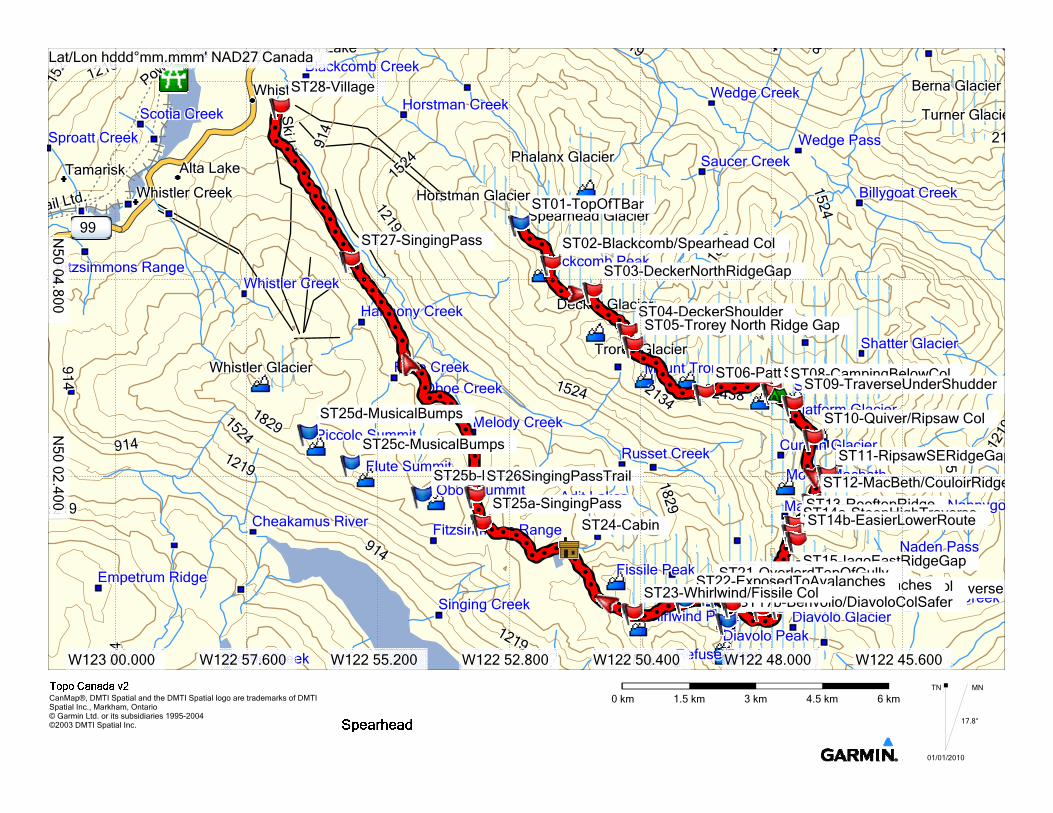
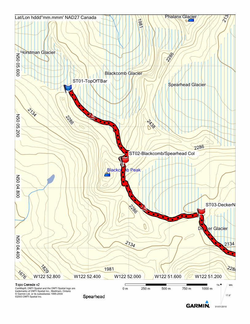
1. From top of Showcase T-bar on Blackcomb, cross Blackcomb Glacier to the Blackcomb-Spearhead col
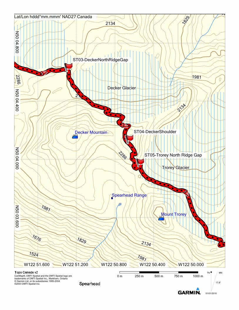
2. Climb over Decker mountain. You can go right over the top to the Trorey-Decker col, or drop down a steep slope from the east ridge of Decker to a lower part of the Trorey Glacier.
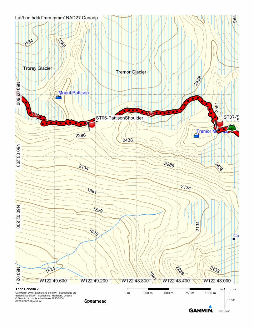
3. Traverse around the North side of Mt. Trorey on the Trorey Glacier. 4. Ski around the south side of Mt. Pattison. 5. Climb to the col between Tremor and Shudder. 6. Traverse the Platform, Ripsaw and Naden Glaciers to the Macbeth Glacier. 7. Follow a ridge off the Macbeth Glacier to the Iago Glacier (steep) and climb the Iago Glacier. 8. Descend off Mt. Iago to the Diavolo Glacier (steep). 9. Climb over Mt. Benvolio and then do a spiralling descent around the N side of Overlord (crevasses). 10. Either descend Overlord Glacier and climb back to Russet Lake, or cross the Fissile-Whirlwind col
and descend to Russet Lake. 11. Head West and descend to Singing Pass. 12. Ski out the singing pass trail to Whistler Village or ski up over the summits of Oboe and Flute to
reach the Whistler downhill ski area and descend the ski runs to Whistler Village.
From the top of the glacier, drop down towards the Decker Glacier, staying low heading S.E. Cross the northern glaciated slopes of Mt Trorey. Good camping can be found here. Mt Pattison can be passed by the northern col or by climbing a short but steep west facing chute south of the peak. Cross the high on the Tremor Glacier, and climb to a narrowing slot between Tremor and Shudder Mountains.
Head S.E on high ground across the Platform Glacier, past good camping sites, to a col just west of Quiver Peak. Traverse the upper western slopes of the Ripsaw Glacier, until you come to a keyhole on the glaciers southern edge. Drop down from here onto the Naden Glacier, passing Mt MacBeth on your right until you reach the top of the Macbeth Glacier, just north of Couloir Ridge. Keeping to the skiers left, drop halfway down the glacier, passing a keyhole view of the Iago Glacier, to gain a south leading ridge. Climb the ridge and follow it south until easier ground enables you to drop down onto the Iago Glacier.
Traverse the top of the Iago glacier, and climb the eastern slopes of Mt Iago, until you can drop down onto the Diavolo Glacier. Circumvent the southern slopes of Mt Iago, and Mt Fitsimmons, passing good sites for camps. Veer westward and then decide between climb the southern slope Mt Benvolio, onto the Benvolio Glacier, and climb the glacier to a point just east of Overlord. Alternatively, you can take a more direct but steeper route climbing to the col between Mt Fizsimmons and Mt Benvolio. Either way, this will get you to the top of the Fitzsimmons Glacier.
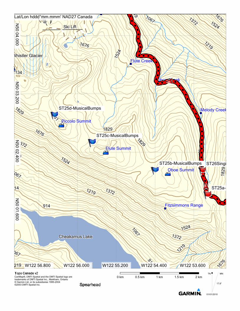
Stay on high ground, approaching Overlord Mountain from the east, passing north of a steep eastern spur off the peak of Overlord, and dropping down onto the Overlord Glacier a little down from the cliffs SW of the main peak. Traverse the upper slopes of the Overlord Glacier, past good camping sites, and climb the mellow slopes west past Whirlwind Peak to a point just south of Fissile Peak. Once on high ground, drop down the shallow west leading valley between of Fissile Peak and an unnamed bluff. Head down this gentle valley towards Russet Lake, easily identified by a cabin on its northern banks. Keeping to the high ground south of the Lake, climb Cowboy Ridge and drop down to the upper reaches of Melody Creek.
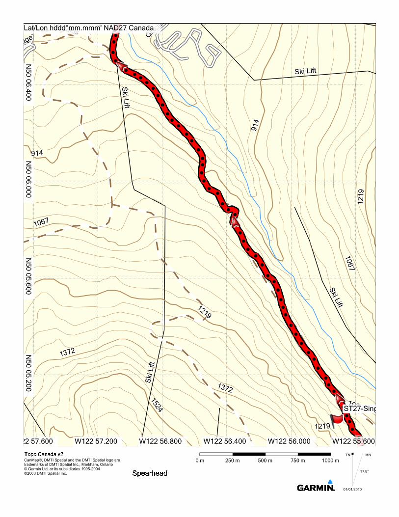
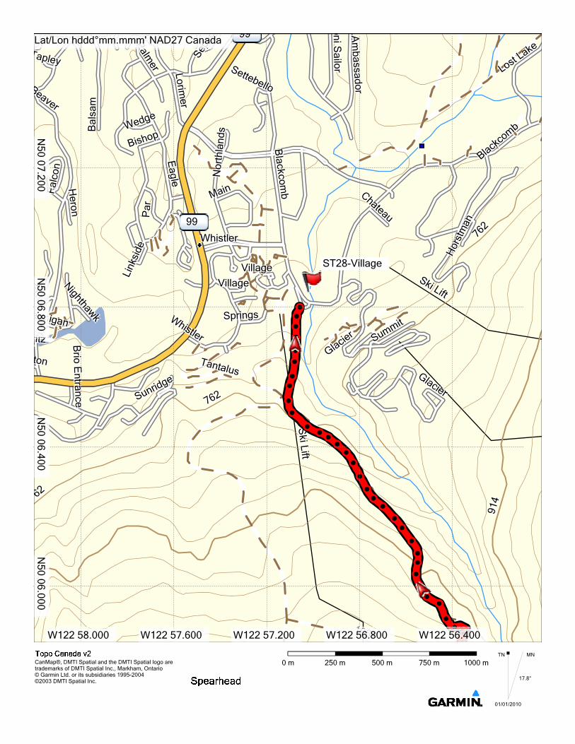
From this point you have two options. You can follow the Singing Pass trail north down the western banks of Melody Creek, leading to a well maintained trail above Fitzsimmons Creek, and then the lower slopes of the resort. Alternatively, you can continue in a westerly direction to climb the slopes of the Musical Bumps, Oboe, Flute and then Piccolo, giving you the entire vertical descent of Whistler ski resort to finish the day.
Whistler CreekWhistler CreekWhistler CreekWhistler Creek
WhistlerWhistlerWhistlerWhistler
Alta LakeAlta LakeAlta LakeAlta LakeTamariskTamariskTamariskTamarisk
99
99
Scotia CreekScotia CreekScotia CreekScotia Creek
Sproatt CreekSproatt CreekSproatt CreekSproatt Creek
Power Lin
Power Lin
Power Lin
Power Lin
1219121912191219
1524
1524
1524
1524
ail Ltd.ail Ltd.ail Ltd.ail Ltd.
Ski Lift
Ski Lift
Ski Lift
Ski Lift
Horstman GlacierHorstman GlacierHorstman GlacierHorstman Glacier
Horstman CreekHorstman CreekHorstman CreekHorstman Creek
Blackcomb CreekBlackcomb CreekBlackcomb CreekBlackcomb Creek
914
914
914
914
1219121912191219
15241524
1524
1524
Lost LakeLost LakeLost LakeLost Lake
Phalanx GlacierPhalanx GlacierPhalanx GlacierPhalanx Glacier
Spearhead GlacierSpearhead GlacierSpearhead GlacierSpearhead Glacier
Saucer CreekSaucer CreekSaucer CreekSaucer Creek
Wedge CreekWedge CreekWedge CreekWedge Creek
191921919 34343434
1829
1829
1829
1829
Berna GlacierBerna GlacierBerna GlacierBerna Glacier
Turner GlacieTurner GlacieTurner GlacieTurner Glacie
Wedge PassWedge PassWedge PassWedge Pass
Billygoat CreekBillygoat CreekBillygoat CreekBillygoat Creek
Pacific RanggPacific Rangg
21212121
38383838
1524152415241524
Whistler GlacierWhistler GlacierWhistler GlacierWhistler Glacier
Whistler CreekWhistler CreekWhistler CreekWhistler CreekFitzsimmons RangeFitzsimmons RangeFitzsimmons RangeFitzsimmons Range
914914914914
18291829182918291524
152415241524
914914914914
Melody CreekMelody CreekMelody CreekMelody Creek
Oboe CreekOboe CreekOboe CreekOboe CreekFlute CreekFlute CreekFlute CreekFlute Creek
Harmony CreekHarmony CreekHarmony CreekHarmony Creek
Piccolo SummitPiccolo SummitPiccolo SummitPiccolo Summit
Trorey GlacierTrorey GlacierTrorey GlacierTrorey Glacier
Decker GlacierDecker GlacierDecker GlacierDecker Glacier
Mount TroreyMount TroreyMount TroreyMount Trorey
Blackcomb PeakBlackcomb PeakBlackcomb PeakBlackcomb Peak
24382438243824382134213421342134
1524152415241524
Platform GlacierPlatform GlacierPlatform GlacierPlatform Glacier
Curtain GlacierCurtain GlacierCurtain GlacierCurtain Glacier
Shatter GlacierShatter GlacierShatter GlacierShatter Glacier
Shudder MountainShudder MountainShudder MountainShudder Mountain
1219
1219
1219
1219
Cheakamus RiverCheakamus RiverCheakamus RiverCheakamus River
Corrie CreekCorrie CreekCorrie CreekCorrie Creek
Empetrum RidgeEmpetrum RidgeEmpetrum RidgeEmpetrum Ridge
1524
1524
1524
1524
1219121912191219
1219121912191219
Singing CreekSinging CreekSinging CreekSinging Creek
Fitzsimmons RangeFitzsimmons RangeFitzsimmons RangeFitzsimmons Range
Flute SummitFlute SummitFlute SummitFlute Summit
Oboe SummitOboe SummitOboe SummitOboe Summit
914914914914
1219121912191219
Adit LakesAdit LakesAdit LakesAdit Lakes
Russet CreekRusset CreekRusset CreekRusset Creek
Refuse CreekRefuse CreekRefuse CreekRefuse Creek
Fissile PeakFissile PeakFissile PeakFissile Peak
Diavolo PeakDiavolo PeakDiavolo PeakDiavolo PeakWhirlwind PeakWhirlwind PeakWhirlwind PeakWhirlwind Peak
2134213421342134
1829182918291829
Naden PassNaden PassNaden PassNaden Pass
Diavolo CreekDiavolo CreekDiavolo CreekDiavolo Creek
NannygoaNannygoNannygoNannygoMacbeth GlacierMacbeth GlacierMacbeth GlacierMacbeth Glacier
Diavolo GlacierDiavolo GlacierDiavolo GlacierDiavolo Glacier
Mount MacbethMount MacbethMount MacbethMount Macbeth
Mount IagoMount IagoMount IagoMount Iago
1524152415241524
ST01-TopOfTBar
ST02-Blackcomb/Spearhead Col
ST03-DeckerNorthRidgeGap
ST04-DeckerShoulderST05-Trorey North Ridge Gap
ST06-PattisonShoulderST07-Tremor/Shudder ColST08-CampingBelowColST09-TraverseUnderShudder
ST10-Quiver/Ripsaw Col
ST11-RipsawSERidgeGap
ST12-MacBeth/CouloirRidgeST13-RooftopRidgeST14a-SteepHighTraverseST14b-EasierLowerRoute
ST15-IagoEastRidgeGap
ST16a-SteepExposedHighTraverseST16b-SaferLowerRouteST17a-FitsimmonsBenvolioColST17b-Benvolio/DiavoloColSaferST18-ExposedToAvalanches
ST19-AFewCrevassesST20-AboveRockPinnacleST21-OverlordTopOfGullyST22-ExposedToAvalanchesST23-Whirlwind/Fissile Col
ST24-CabinST25a-SingingPass
ST25b-MusicalBumps
ST25c-MusicalBumps
ST25d-MusicalBumps
ST26SingingPassTrail
ST27-SingingPass
ST28-Village
Lat/Lon hddd°mm.mmm' NAD27 Canada
W123 00.000 W122 57.600 W122 55.200 W122 52.800 W122 50.400 W122 48.000 W122 45.600
N50 02.400
N50 04.800
CanMap®, DMTI Spatial and the DMTI Spatial logo are trademarks of DMTI Spatial Inc., Markham, Ontario© Garmin Ltd. or its subsidiaries 1995-2004©2003 DMTI Spatial Inc.
6 km4.5 km3 km1.5 km0 kmMNTN
01/01/2010
17.8°
Page 1
SpearheadRoute
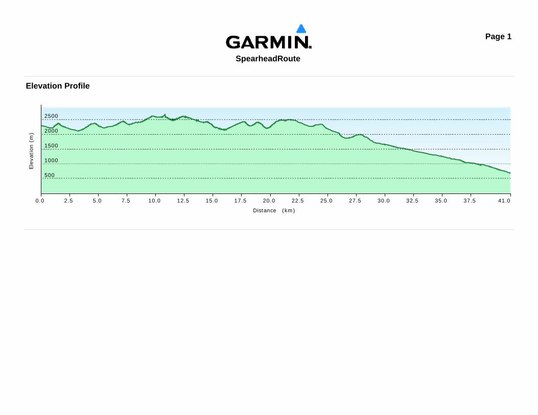
Elevation Profile
Elev
atio
n (m
)
500
1000
1500
2000
2500
Distance (km)
0.0 2.5 5.0 7.5 10.0 12.5 15.0 17.5 20.0 22.5 25.0 27.5 30.0 32.5 35.0 37.5 41.0
Horstman GlacierHorstman GlacierHorstman GlacierHorstman Glacier
Blackcomb GlacierBlackcomb GlacierBlackcomb GlacierBlackcomb Glacier
2929
1981198119811981
Phalanx GlacierPhalanx GlacierPhalanx GlacierPhalanx Glacier
2134
2134
2134
2134
2286
2286
2286
2286
2134213421342134 2286
228622862286 2438
243824382438
Spearhead GlacierSpearhead GlacierSpearhead GlacierSpearhead Glacier
Blackcomb PeakBlackcomb PeakBlackcomb PeakBlackcomb Peak
2286228622862286
2286228622862286
18291829182918291676
167616761676
2134213421342134
1981198119811981
Decker GlacierDecker GlacierDecker GlacierDecker Glacier
2134213421342134
2286228622862286
ST01-TopOfTBar
ST02-Blackcomb/Spearhead Col
ST03-DeckerN
Lat/Lon hddd°mm.mmm' NAD27 Canada
W122 52.800 W122 52.400 W122 52.000 W122 51.600 W122 51.200
N50 04.400
N50 04.800
N50 05.200
N50 05.600
CanMap®, DMTI Spatial and the DMTI Spatial logo are trademarks of DMTI Spatial Inc., Markham, Ontario© Garmin Ltd. or its subsidiaries 1995-2004©2003 DMTI Spatial Inc.
1000 m750 m500 m250 m0 mMNTN
01/01/2010
17.8°
2134213421342134 1829
1829
1829
1829
6766716767
Decker MountainDecker MountainDecker MountainDecker Mountain
2134213421342134
2286228622862286
Decker GlacierDecker GlacierDecker GlacierDecker Glacier
2134213421342134
1981198119811981
Spearhead RangeSpearhead RangeSpearhead RangeSpearhead Range
2286228622862286
Trorey GlacierTrorey GlacierTrorey GlacierTrorey Glacier
1829182918291829
1524152415241524
1981198119811981
1676167616761676
2134213421342134
1981198119811981
Mount TroreyMount TroreyMount TroreyMount Trorey
ST03-DeckerNorthRidgeGap
ST04-DeckerShoulder
ST05-Trorey North Ridge Gap
Lat/Lon hddd°mm.mmm' NAD27 Canada
W122 51.600 W122 51.200 W122 50.800 W122 50.400 W122 50.000
N50 03.600
N50 04.000
N50 04.400
N50 04.800
CanMap®, DMTI Spatial and the DMTI Spatial logo are trademarks of DMTI Spatial Inc., Markham, Ontario© Garmin Ltd. or its subsidiaries 1995-2004©2003 DMTI Spatial Inc.
1000 m750 m500 m250 m0 mMNTN
01/01/2010
17.8°
Trorey GlacierTrorey GlacierTrorey GlacierTrorey Glacier
2134213421342134
2286228622862286
Tremor GlacierTremor GlacierTremor GlacierTremor Glacier
3443434
2438
2438
2438
2438
286228622862286
Mount PattisonMount PattisonMount PattisonMount Pattison
22862286228622862438243824382438
Tremor MountainTremor MountainTremor MountainTremor Mountain
2591
2591
2591
2591
2134213421342134
1829182918291829
1981198119811981
2438243824382438
2134213421342134
2286228622862286
1524152415241524 1981
198119811981
1676167616761676
CurCuCuCu
2134
2134
2134
2134
2438243824382438
2286228622862286
ST06-PattisonShoulder ST07-TrS
Lat/Lon hddd°mm.mmm' NAD27 Canada
W122 49.600 W122 49.200 W122 48.800 W122 48.400 W122 48.000
N50 02.4
N50 02.800
N50 03.200
N50 03.600
CanMap®, DMTI Spatial and the DMTI Spatial logo are trademarks of DMTI Spatial Inc., Markham, Ontario© Garmin Ltd. or its subsidiaries 1995-2004©2003 DMTI Spatial Inc.
1000 m750 m500 m250 m0 mMNTN
01/01/2010
17.8°
mor Glaciermor Glaciermor Glaciermor Glacier
Tremor MountainTremor MountainTremor MountainTremor Mountain
2591
2591
2591
2591
2438243824382438
Shudder MountainShudder MountainShudder MountainShudder Mountain
2438243824382438
2134213421342134
2286228622862286
Platform GlacierPlatform GlacierPlatform GlacierPlatform Glacier
Quiver PeakQuiver PeakQuiver PeakQuiver Peak2591259125912591
2438
2438
2438
2438
21342134
2134
2134
2286228622862286
19811981
1981
1981
Curtain GlacierCurtain GlacierCurtain GlacierCurtain Glacier
Ripsaw GlacierRipsaw GlacierRipsaw GlacierRipsaw Glacier
2286228622862286
Macbeth GlacierMacbeth GlacierMacbeth GlacierMacbeth Glacier
Mount MacbethMount MacbethMount MacbethMount Macbeth2134213421342134
2286228622862286
1981198119811981 Couloir RidgeCouloir RidgeCouloir RidgeCouloir Ridge
2438243824382438
Naden GlacierNaden GlacierNaden GlacierNaden Glacier
2134213421342134
ST07-Tremor/Shudder ColST08-CampingBelowCol
ST09-TraverseUnderShudder
ST10-Quiver/Ripsaw Col
ST11-RipsawSERidgeGap
ST12-MacBeth/CouloirRidgeCol
Lat/Lon hddd°mm.mmm' NAD27 Canada
W122 48.000 W122 47.600 W122 47.200 W122 46.800 W122 46.400
N50 02.000
N50 02.400
N50 02.800
N50 03.200
CanMap®, DMTI Spatial and the DMTI Spatial logo are trademarks of DMTI Spatial Inc., Markham, Ontario© Garmin Ltd. or its subsidiaries 1995-2004©2003 DMTI Spatial Inc.
1000 m750 m500 m250 m0 mMNTN
01/01/2010
17.8°
2134213421342134
2286228622862286
1981198119811981
Macbeth GlacierMacbeth GlacierMacbeth GlacierMacbeth Glacier
Couloir RidgeCouloir RidgeCouloir RidgeCouloir Ridge
Mount MacbethMount MacbethMount MacbethMount Macbeth
2438
2438
2438
2438
Naden GlaNaden GlaNaden GlaNaden Gla
Fitzsimmons GlacierFitzsimmons GlacierFitzsimmons GlacierFitzsimmons Glacier
82982982982921
3421
3421
3421
34
2286228622862286
2134213421342134
22862286
2286
2286
1981198119811981
Iago GlacierIago GlacierIago GlacierIago Glacier
2438243824382438
1981198119811981
Mount FitzsimmonsMount FitzsimmonsMount FitzsimmonsMount Fitzsimmons
Mount IagoMount IagoMount IagoMount Iago
2438243824382438
2591259125912591
2134213421342134
16761671671676
1829182918291829
1981198119811981
ST12-MacBeth/CouloirRidgeCol
ST13-RooftopRidge
ST14a-SteepHighTraverse
ST14b-EasierLowerRoute
ST15-IagoEastRidgeGap
ST16a-SteepExposedHighTraverseST16b-SaferLowerRouteST17a-FitsimmonsBenvolioCol
Lat/Lon hddd°mm.mmm' NAD27 Canada
W122 48.400 W122 48.000 W122 47.600 W122 47.200 W122 46.800
N50 00.800
N50 01.200
N50 01.600
N50 02.000
CanMap®, DMTI Spatial and the DMTI Spatial logo are trademarks of DMTI Spatial Inc., Markham, Ontario© Garmin Ltd. or its subsidiaries 1995-2004©2003 DMTI Spatial Inc.
1000 m750 m500 m250 m0 mMNTN
01/01/2010
17.8°
2134213421342134
Fitzsimmons GlacierFitzsimmons GlacierFitzsimmons GlacierFitzsimmons Glacier
2134
2134
2134
2134
2286
2286
2286
2286
981981981981
Overlord MountainOverlord MountainOverlord MountainOverlord Mountain
2438243824382438
21342134213421342286
228622862286
1981198119811981
Mount IagoMount IagoMount IagoMount Iago
228228228228
2438243824382438
2286228622862286
Benvolio GlacierBenvolio GlacierBenvolio GlacierBenvolio Glacier
Mount BenvolioMount BenvolioMount BenvolioMount Benvolio
2591
2591
2591
2591
Mount FitzsimmonsMount FitzsimmonsMount FitzsimmonsMount Fitzsimmons
Refuse CreekRefuse CreekRefuse CreekRefuse Creek
2134
2134
2134
2134
1981198119811981
Angelo PeakAngelo PeakAngelo PeakAngelo Peak
Diavolo PeakDiavolo PeakDiavolo PeakDiavolo Peak2438243824382438
2286228622862286
228228228228
2438243824382438
ST16a-SteepExposedHighST16b-SST17a-FitsimmonsBenvolioCol
ST17b-Benvolio/DiavoloColSafer
ST18-ExposedToAvalanches
ST19-AFewCrevasses
ST20-AboveRockPinnacleST21-OverlordTopOfGully
ST22-ExposedToAvalanches
Lat/Lon hddd°mm.mmm' NAD27 Canada
W122 49.600 W122 49.200 W122 48.800 W122 48.400 W122 48.000
N50 00.400
N50 00.800
N50 01.200
N50 01.600
CanMap®, DMTI Spatial and the DMTI Spatial logo are trademarks of DMTI Spatial Inc., Markham, Ontario© Garmin Ltd. or its subsidiaries 1995-2004©2003 DMTI Spatial Inc.
1000 m750 m500 m250 m0 mMNTN
01/01/2010
17.8°
Russet CreekRusset CreekRusset CreekRusset Creek
1829182918291829
1676167616761676
1829182918291829
2134213421342134
Fissile PeakFissile PeakFissile PeakFissile Peak
1981198119811981
Overlord GlacierOverlord GlacierOverlord GlacierOverlord Glacier
2134213421342134
Whirlwind PeakWhirlwind PeakWhirlwind PeakWhirlwind Peak
2286228622862286
2438243824382438
2591
2591
2591
2591
1676
1676
1676
1676
1829
1829
1829
1829
1981198119811981
2438243824382438
21342134
2134
2134
2286228622862286
Refuse CreekRefuse CreekRefuse CreekRefuse Creek
1981198119811981
ST22-ExposedT
ST23-Whirlwind/Fissile Col
Lat/Lon hddd°mm.mmm' NAD27 Canada
W122 51.200 W122 50.800 W122 50.400 W122 50.000 W122 49.600
N50 00.400
N50 00.800
N50 01.200
N50 01.600
CanMap®, DMTI Spatial and the DMTI Spatial logo are trademarks of DMTI Spatial Inc., Markham, Ontario© Garmin Ltd. or its subsidiaries 1995-2004©2003 DMTI Spatial Inc.
1000 m750 m500 m250 m0 mMNTN
01/01/2010
17.8°
Adit LakesAdit LakesAdit LakesAdit Lakes
Adit CreekAdit CreekAdit CreekAdit Creek
1829182918291829
151
1676167616761676
1981198119811981
Russet LakeRusset LakeRusset LakeRusset Lake
Russet CreekRusset CreekRusset CreekRusset Creek
18291829
1829
1829
1981198119811981
Fissile PeakFissile PeakFissile PeakFissile Peak
1829182918291829
1524152415241524
1676167616761676
1829
1829
1829
1829 19811981
19811981
WhWhWhWh
2438243824382438
2134213421342134
2286228622862286
ST23-W
ST24-Cabin
Lat/Lon hddd°mm.mmm' NAD27 Canada
W122 52.400 W122 52.000 W122 51.600 W122 51.200 W122 50.800
N50 00.800
N50 01.200
N50 01.600
CanMap®, DMTI Spatial and the DMTI Spatial logo are trademarks of DMTI Spatial Inc., Markham, Ontario© Garmin Ltd. or its subsidiaries 1995-2004©2003 DMTI Spatial Inc.
1000 m750 m500 m250 m0 mMNTN
01/01/2010
17.8°
1676167616761676 18291829
18291829
1524152415241524
1676167616761676
1829182918291829
1981198119811981
Adit LakesAdit LakesAdit LakesAdit Lakes
1676167616761676
1829182918291829
1829182918291829
1219121912191219
1524152415241524
1372137213721372
18291829182918291676
167616761676 19
8119
8119
8119
81
Russet LakeRusset LakeRusset LakeRusset Lake
ST24-Ca
ST25a-SingingPass
ST26SingingPassTrail
Lat/Lon hddd°mm.mmm' NAD27 Canada
22 53.600 W122 53.200 W122 52.800 W122 52.400 W122 52.000 W122 51.600
N50 01.200
N50 01.600
N50 02.000
N50 02.400
CanMap®, DMTI Spatial and the DMTI Spatial logo are trademarks of DMTI Spatial Inc., Markham, Ontario© Garmin Ltd. or its subsidiaries 1995-2004©2003 DMTI Spatial Inc.
1000 m750 m500 m250 m0 mMNTN
01/01/2010
17.8°
Flute CreekFlute CreekFlute CreekFlute Creek
1524
1524
1524
1524
1372137213721372
1219121912191219
1372137213721372
1676167616761676
Oboe CreekOboe CreekOboe CreekOboe Creek
Melody CreekMelody CreekMelody CreekMelody Creek
1524152415241524
18291829182918298181
98181
1676167616761676
Oboe SummitOboe SummitOboe SummitOboe Summit
1829182918291829
ST25b-MusicalBumps ST26SingingPas
Lat/Lon hddd°mm.mmm' NAD27 Canada
2 55.200 W122 54.800 W122 54.400 W122 54.000 W122 53.600 W122 53.200
N50 02.400
N50 02.800
N50 03.200
N50 03.600
CanMap®, DMTI Spatial and the DMTI Spatial logo are trademarks of DMTI Spatial Inc., Markham, Ontario© Garmin Ltd. or its subsidiaries 1995-2004©2003 DMTI Spatial Inc.
1000 m750 m500 m250 m0 mMNTN
01/01/2010
17.8°
1219121912191219
1067106710671067
1372137213721372
1219121912191219
iftiftLiftift
1524152415241524
22
1524152415241524
1219121912191219
1067106710671067
1372137213721372
1676167616761676
ki LiftSki LiftSki Liftki Lift
Harmony CreekHarmony CreekHarmony CreekHarmony Creek
1524152415241524
1219121912191219
1829
1829
1829
1829
1524
1524
1524
1524
Flute CreekFlute CreekFlute CreekFlute Creek
1219121912191219
1372137213721372
ST27-SingingPass
Lat/Lon hddd°mm.mmm' NAD27 Canada
56.400 W122 56.000 W122 55.600 W122 55.200 W122 54.800 W122 54.400
N50 04.000
N50 04.400
N50 04.800
CanMap®, DMTI Spatial and the DMTI Spatial logo are trademarks of DMTI Spatial Inc., Markham, Ontario© Garmin Ltd. or its subsidiaries 1995-2004©2003 DMTI Spatial Inc.
1000 m750 m500 m250 m0 mMNTN
01/01/2010
17.8°
dgedgedgedge
TantalusTantalusTantalusTantalus
Ski Lift
Ski Lift
Ski Lift
Ski Lift
Glacier
Glacie
Glacier
Glacier
914
914
914
914
Ski LiftSki LiftSki LiftSki Lift
914914914914
1067106710671067
1219
1219
1219
1219
219219
1219219
1219121912191219
1067106710671067
Ski LiftSki LiftSki LiftSki Lift
1372137213721372
1524152415241524
1372137213721372
Ski
Lift
Ski
Lift
Ski
Lift
Ski
Lift
1219121912191219
1067106710671067ST27-Sing
Lat/Lon hddd°mm.mmm' NAD27 Canada
22 57.600 W122 57.200 W122 56.800 W122 56.400 W122 56.000 W122 55.600
N50 05.200
N50 05.600
N50 06.000
N50 06.400
CanMap®, DMTI Spatial and the DMTI Spatial logo are trademarks of DMTI Spatial Inc., Markham, Ontario© Garmin Ltd. or its subsidiaries 1995-2004©2003 DMTI Spatial Inc.
1000 m750 m500 m250 m0 mMNTN
01/01/2010
17.8°
Beaver
Beaver
Beaver
Beaver
TapleyTapleyTapleyTapley
WedgeWedgeWedgeWedge
OboeoeOboeboe
Bal
sam
Ba l
s am
Bal
sam
Bal
sam
Lorimer
Lorimer
Lorimer
Lorimer
Palmer
Palmer
Palmer
Palmer
Falc
onFa
lcon
Falc
onFa
lcon
BishopBishopBishopBishop
Eagle
Eagle
Eagle
Eagle
99
Settebello
Settebello
Settebello
Settebello
oni Sailo r
on i Sa ilo r
oni Sailor
on i Sailo r
Am
bassadorA
mbassador
Am
bassadorA
mbassador
Blackcom
bB
lackcomb
Blackcom
bB
lackcomb
Sepp
os
Sepp
oSe
ppos
Sepp
osN
orth
land
sN
orth
land
sN
orth
land
sN
orth
land
s
Lost Lake
Lost Lake
Lost Lake
Lost Lake
Blackco
mb
Blackco
mb
Blackco
mb
Blackco
mb
WhistlerWhistlerWhistlerWhistler
99
Heron
Heron
Heron
Heron
ParPar
Par
Par
Nighthawk
Nighthawk
Nighthawk
Nighthawk
Link
side
Link
side
Link
side
Link
side
armigantarmiganarmiganarmigan
eak
eak
eak
eak VillageVillageVillageVillage
VillageVillageVillageVillage
MainMainMainMain
SpringsSpringsSpringsSprings
SummitSummit
Summit
Summit
Hor
stm
an
Hor
stm
an
Hor
stm
an
Hor
stm
an
Chateau
Chateau
Chateau
Chateau
762762
762
762
Ski LiftSki LiftSki Lift
Ski Lift
SunridgeSunridge
Sunridge
Sunridge
Brio E
ntranceB
rio Entrance
Brio E
ntranceB
rio Entrance
ritzritzritzritz
Whistler
Whistler
Whistler
Whistler
tonntontontonGlacie
rGlacie
r
Glacier
Glacier
762762762762
TantalusTantalusTantalusTantalus
Ski Lift
Ski Lift
Ski Lift
Ski Lift
Glacier
GlacierGlacier
Glacier
4444
762762762762
1067106710671067
914
914
914
914
ST28-Village
Lat/Lon hddd°mm.mmm' NAD27 Canada
W122 58.000 W122 57.600 W122 57.200 W122 56.800 W122 56.400
N50 06.000
N50 06.400
N50 06.800
N50 07.200
CanMap®, DMTI Spatial and the DMTI Spatial logo are trademarks of DMTI Spatial Inc., Markham, Ontario© Garmin Ltd. or its subsidiaries 1995-2004©2003 DMTI Spatial Inc.
1000 m750 m500 m250 m0 mMNTN
01/01/2010
17.8°
Whistler GlacierWhistler GlacierWhistler GlacierWhistler Glacier
2134213421342134
1829182918291829
1676167616761676
Ski LiftSki LiftSki LiftSki Lift
Flute CreekFlute CreekFlute CreekFlute Creek
191921919
1524
1524
1524
1524
1067106710671067
1219121912191219
1524152415241524
1372137213721372
1676167616761676
Piccolo SummitPiccolo SummitPiccolo SummitPiccolo Summit
1829182918291829 1981
198119811981
1676167616761676
1829182918291829
Melody CreekMelody CreekMelody CreekMelody Creek
Oboe CreekOboe CreekOboe CreekOboe Creek
1491491414
1219121912191219 1524
152415241524
1067106710671067
1372137213721372
Flute SummitFlute SummitFlute SummitFlute Summit
1219121912191219
1829182918291829
1372137213721372
Oboe SummitOboe SummitOboe SummitOboe Summit
1829
1829
1829
1829
1676167616761676
Cheakamus LakeCheakamus LakeCheakamus LakeCheakamus Lake
914914914914
219219219219
067067067067
914914914914
1067106710671067
Fitzsimmons RangeFitzsimmons RangeFitzsimmons RangeFitzsimmons Range
1219121912191219
1524152415241524
1372137213721372
16761676
1676
1676
ST25a-S
ST25b-MusicalBumps
ST25c-MusicalBumps
ST25d-MusicalBumps
ST26Singi
Lat/Lon hddd°mm.mmm' NAD27 Canada
W122 56.800 W122 56.000 W122 55.200 W122 54.400 W122 53.600
N50 01.600
N50 02.400
N50 03.200
N50 04.000
CanMap®, DMTI Spatial and the DMTI Spatial logo are trademarks of DMTI Spatial Inc., Markham, Ontario© Garmin Ltd. or its subsidiaries 1995-2004©2003 DMTI Spatial Inc.
2 km1.5 km1 km0.5 km0 kmMNTN
01/01/2010
17.8°
Top Related