


Languages
Pages
Legal

PocklingtonStamford Bridge
MarketWeighton
Ulceby
Keelby
Winterton
Brigg
Wragby
Bawtry
Beckingham Louth
NorthSomercotes
Bolsover
MarketWarsop
Dri�ield
BubwithTadcaster
HowdenCastleford
HornseaLeven
Skipsea
WithernseaHedon
Barton-upon-Humber
Beverley
Thorne
Caistor
Retford
Blyth
Saxilby
Waddington
Metheringham
HorncastleWoodhall
Spa
MarketRasen
Tattershall
SpilsbyOllerton
TuxfordStaveley
Cleethorpes
Cottingham
Hessle
Bentley
NorthHykeham
Gainsborough
Immingham
Newark-on-Trent
Worksop
Selby
Goole
Wetherby
Pontefract
Rotherham
Kingstonupon Hull
York
DoncasterScunthorpe
Grimsby
Lincoln
Mansfield
HU130
HU107
HU203
NG200
DN68DN157
YO88WF105
DN67
DN156
YO86
WF104
NG172
S611
S738
YO421
DN311
LN35
DN60
YO85
WF103
S139
S92
HU89
DN417
YO415
HU175
DN33
LN13 LN34
DN59
DN150
WF102
NG171
S605S91
S730
YO414
HU170
DN32
LN12
YO244
WF101
S138
NG166
S604
S819S261
HU88
DN403
S729
YO411
DN31
LN25
YO243
DN58
YO84
S137
S603
HU87
S410
DN402
YO329
LN11
YO242
DN149
S124
S602
S818
HU80
S728
HU165
DN229
YO241
S669
DN57
DN148
YO83
S817
HU76
DN401
S727
YO324
HU164
DN228
LN24
YO237
S668
DN50
DN147
S123
S601
S810
HU75
DN49
HU152
DN227
LN23
YO233
S667
DN418
DN146
S804
HU74
DN48
S720
YO323
DN226
YO232
S663
DN145
YO901
HU73
LN96
S715
HU151
DN220LN22
YO231
DN140
WF95
HU70
DN47
LN95
YO322
HU143
DN215
LN21
S662
DN124
WF94
S803
S253
HU69
DN46
LN86
DN214
S211
DN123
WF93
NG159
DN331
HU68
LN85
YO319
HU139
DN213
LN130
S661
DN122
WF92
NG158
S802
HU67
DN45
LN83
YO318
NG199
S654
DN121
WF91
HU60
DN40
S267
DN212
S208
NG198
S653
DN119
HU55
DN396
LN82
YO317
DE557
HU129
DN211
S207
NG197
S652
DN118
WF84
S801
LS269
HU54
DN386
LN76
YO311
HU128
S266
DN209
S206
NG196
S651
DN110
WF83
HU53
DN379
YO310
DE555
DN208
LN119
S649
WF82
HU52
DN378
LN69
HU120
S265
DN200
S205
NG190
S648
PE235
LS257HU51
DN377
LN68
DE554
DN26
LN118
YO196
S645
DN106
WF81
DN370
YO307
HU115
S264
S203
NG185
S640
DN105
PE234
WF77
LS256
HU47
DN365
LN67
DE553
HU114
DN25
LN117
S202
YO195
NG184
S639
DN104
WF76
YO105
LS255
DN364
LN65
S263
DN24
LN110
S201
NG183
S638 DN13
PE228
WF75
YO104
LS254
HU46
LN64
YO306
DE552
DN197
LN106
PE227
YO103
LS253
HU36
DN359
YO305
DE551
HU106
S262
DN186
LN105
YO194
NG182
DN12
LS252
DN358
LN63
YO304
HU13
DN185
S637
DN11
YO19
LS251
HU35
DN357
S255
DN174
NG181
WF61
S459
HU34
LN60
YO301
NG242
DN173
S458
NG241
HU12
S254
DN172
NG179
S636
YO18
LS249
HU33
DN350
LN59
YO268
NG237
HU11
DN171
NG178
S446
LS248
HU32
DN345
YO267
NG236
S252
NG177
S635
S445
LS237
HU31
DN344
YO266
DN163S630
YO17
S434
LS236
HU29
DN333
LN58
YO265
DN93
S251
S627
YO16
S433
LS227
HU28
DN332
YO264
DN92
WF119
NG176
S626
S432
HU20
LN57
YO259
NG229
DN91
S215
NG175
HU95
S748
HU192
DN329
LN50
NG228
DN85
S214
DN162
WF118
S625
S431
LS226 HU181
DN328
LN44
NG220
DN84
S213
DN161
NG174
YO434
HU179
LN43
YO258
NG219
DN76
DN159WF110
S614
HU94
DN327
LN42
NG210
DN75
S212
NG173
S613
HU93
LS225
YO433
S204
DN320
LN41
LS154
YO256
NG209
DN74
DN158
S95
HU92
YO424
HU178
DN313
YO255
NG208
DN69
YO89
S94
WF41
HU91
S425
S739
YO422
HU177
DN312
2018 - www.gbmaps.com2018 - www.gbmaps.com
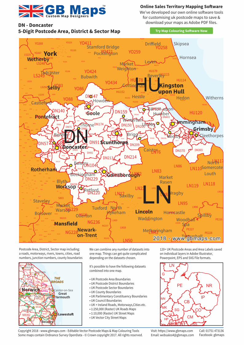
DN - Doncaster5-Digit Postcode Area, District & Sector Map
Copyright 2018 - www.gbmaps.com - Editable Vector Postcode Maps & Map Colouring Tools Some maps contain Ordnance Survey OpenData - © Crown copyright 2017. All rights reserved.
Visit: https://www.gbmaps.comEmail: [email protected]
Call: 01751 473136Facebook: gbmaps
We’ve developed our own online so�ware tools for customising uk postcode maps to save &
download your maps as Adobe PDF files.
Online Sales Territory Mapping So�ware
Try Map Colouring So�ware Now
AL
CB
CMCO
EN
HA
HPIG
IP
LN
LU
MK
N
G
NN
NRPE
SG
SSWD
R Ant
R ThurneA149
A1064
A1062
A146
A143
A12
A47
R Yare
THEBROADS
Loddon
Stalham
NorthWalsham
Caister-on-Sea
AcleGreat
Yarmouth
Beccles
Norwich
Lowesto�
NR280
NR147
NR146
NR340
NR136
NR135
NR339
NR134
NR338
NR133
NR337
NR129
NR128
NR330
NR325
NR120
NR324
NR323 NR322NR321
NR319NR318
NR79
NR317
NR316
NR70
NR310
NR305
NR304
NR303
NR302
NR301
NR352
NR295 NR294
NR293
NR351
NR289
NR349
Postcode Area, District, Sector map including:a roads, motorways, rivers, towns, cities, road numbers, junction numbers, county boundaries
120+ UK Postcode Areas and Area Labels saved on individual layers in Adobe Illustrator, Powerpoint, EPS and SVG File formats.
We can combine any number of datasets into one map. Things can get quite complicated depending on the datasets chosen.
It’s possible to have the following datasets combined into one map.
• UK Postcode Area Boundaries• UK Postcode District Boundaries• UK Postcode Sector Boundaries• UK County Boundaries• UK Parlimentary Constituency Boundaries• UK Council Boundaries• UK + Ireland Roads, Motorways,Cities etc.• 1:250,000 (Raster) UK Roads Maps• 1:10,000 (Raster) UK Street Maps• UK Vector City Street Maps
Custom Map Designers
TM
Top Related