


Languages
Pages
Legal


Wild Coast SEZ: Terrestrial Ecological Assessment Report July 2018
i
PROPOSED WILD COAST SPECIAL ECONOMIC ZONE
MTHATHA, KING SABATA DALINDYEBO LOCAL MUNICIPALITY, EASTERN CAPE
Terrestrial Ecological Assessment Report
Version: 0.1
DRAFT FOR COMMENT
Date: 12th July 2018
Eco-Pulse Environmental Consulting Services
Report No: EP341-03

Wild Coast SEZ: Terrestrial Ecological Assessment Report July 2018
ii
Prepared for: WSP: Environment & Energy, Africa
Building C, Knightsbridge
33 Sloane Street, Bryanston 2191, South Africa
Ms. Ashlea Strong (Principal Consultant)
T +27 11 361 1392
M +27 82 786 7819
Email: [email protected]
Prepared by: Eco-Pulse Environmental Consulting Services
1 Mallory Road, Hilton, 3245, South Africa
Mr. Adam Teixeira-Leite Pr.Sci.Nat. (Senior Wetland/Terrestrial Ecologist)
Tel: 031 2666 700
Mobile: 082 310 6769
E-mail: [email protected]
Suggested report citation:
Eco-Pulse Consulting. 2018. Proposed Wild Coast SEZ, Eastern Cape. Terrestrial Ecological Assessment
Report. Unpublished report prepared by Eco-Pulse Env ironmental Consulting Serv ices for WSP. Report
No. EP341-03. Version 0.1 (DRAFT). 12th July 2018

Wild Coast SEZ: Terrestrial Ecological Assessment Report July 2018
iii
SPECIALIST ASSESSMENT REPORT DETAILS AND
DECLARATION OF INDEPENDENCE
This is to certify that the following specialist vegetation assessment report has been prepared has been
prepared independently of any influence or prejudice as may be specified by the Department of
Env ironmental Affairs (DEA).
Document Title: Terrestrial Ecological Habitat Impact Assessment Report for the proposed Wild
Coast Special Economic Zone (SEZ)
Report Number: EP341-02
Version Number: 0.1 (DRAFT)
Date: 12th July 2018
Report prepared by:
Mr Brian Mafela (BSc. Hons. Forest Resources & Wildlife Management)
Candidate Natural Scientist (Cand. Sci. Nat.) (Ecological Science)
SACNASP Registration Number: 100214/15
Mr Adam Teixeira-Leite (BSc. Hons. Environmental Science)
Professional Natural Scientist (Pr. Sci. Nat.) (Ecological Science)
SACNASP Registration Number: 400332/13
Sign-off:
Mr Adam Teixeira-Leite Pr.Sci.Nat.
Client: WSP (on behalf of Coega Development Corporation [CDC])
I, Adam Teixeira-Leite, hereby declare that this report has been prepared independently of any
influence or prejudice as may be specified by the Department of Environmental Affairs (DEA).
Signed: Date: 12th July 2018

Wild Coast SEZ: Terrestrial Ecological Assessment Report July 2018
iv
DETAILS OF PROJECT TEAM
The relevant experience of specialist team members from Eco-Pulse Consulting involved in the
assessment and compilation of this report are briefly summarized below. Curriculum Vitae’s of the
specialist team are available on request.
Specialist Role Details
Adam Teixeira-Leite
Pr.Sci.Nat.
Senior
Scientist
Project
leader, Co-
Author and
Internal
rev iewer
Adam is a Senior Environmental Scientist at Eco-Pulse with a BSc.
Honours degree in Environmental Science: Earth Sciences. He is a
registered Professional Natural Scientist (Pr. Sci. Nat.) in the ‘Ecological
Sciences’ field of practice with SACNASP, with over 10 years’
experience, hav ing worked extensively on numerous specialist
ecological assessment projects, both for wetland/aquatic and
terrestrial (grasslands and forests) habitats and ecosystems in KZN, the
Free State, Gauteng, Eastern Cape, Western Cape and Lesotho. He is
also experienced in undertaking alien plant surveys and developing
ecological rehabilitation and management plans and programmes.
Brian Mafela
Cand.Sci.Nat.
Env ironmental
Scientist
Fieldwork &
Lead author
Brian Mafela is an Env ironmental Scientist at Eco-Pulse with a BSc.
Honours degree in Forest Resources and Wildlife Management. Brian is
a registered Candidate Natural Scientist (Cand. Sci. Nat.) with over 6
years’ experience in undertaking EIA processes, wetland and riparian
assessments, vegetation assessments, identifying and evaluating
impacts of developments on the env ironment and providing Best
Management Practice (BMP) mitigation measures.
Eco-Pulse would like to acknowledge and thank Mr. David Styles (Specialist Botanist) who was
consulted for specialist input as part of the botanical field assessment. Dav id is a recognised botanist in
South Africa who has worked extensively along the east coast of South Africa (KZN and Eastern Cape)
and is very experienced with identifying plant species. Dav id Styles accompanied Brian Mafela during
the field work to identify the plant species encountered and prov ide a short description of the
identified vegetation communities and plant species.

Wild Coast SEZ: Terrestrial Ecological Assessment Report July 2018
v
EXECUTIVE SUMMARY
The Coega Development Corporation (CDC) intends to develop Phase 1 of the Wild Coast Special
Economic Zone (ECSEZ), located immediately adjacent to the existing Mthatha Airport north-west of
Mthatha town in the Eastern Cape Prov ince of South Africa. The intended development will be for
agricultural land use and a ‘mixed-use’ type development comprising: hotel & conferencing,
commercial space, industrial land use and intensive agriculture & business process outsourcing.
In order to inform the Env ironmental Impact Assessment (EIA) for the planned development, a terrestrial
ecological baseline and habitat/biodiversity impact assessment was undertaken by Eco-Pulse
Consulting to satisfy the requirements of the Department of Env ironmental Affairs (DEA) and the
National Env ironmental Management Act No. 107 (and NEMA EIA regulations) of 1998
This report sets out the findings of the Specialist Terrestrial Ecological Impact Assessment undertaken
between March and July 2018. The main findings of this report have been summarized below as
follows:
Baseline Assessment:
1. Two terrestrial vegetation communities were identified for the site and surrounding area
(shown mapped below), including:
a. Slightly Modified Primary Mthatha Moist Grassland: considered to be predominantly
intact and of ‘moderately-high’ EIS (ecological importance/sensitiv ity) and found
exclusively on the northern property and accounting for roughly 141 hectares (ha) of
the property;
b. Degraded Secondary Grassland: considered to be in a degraded/seriously modified
condition and of ‘Low’ EIS and found exclusively on the southern property and
accounting for roughly 45 hectares (ha) of the property.

Wild Coast SEZ: Terrestrial Ecological Assessment Report July 2018
vi
2. Protected plants occurring on the site appeared to be restricted to the southern property
where two indiv iduals of the species Gladiolus ecklonii were identified in the field.
3. A desktop faunal Potential Occurrence Assessment (POA) was undertaken for the study
area and habitat for species was ground-truthed in the field in March 2018. The findings of
the fauna POC assessment indicate:
a. The lack of species-specific habitat for most of the mammals, reptiles and amphibians
greatly reduces the likelihood of their occurrence at the site.
b. The likelihood of occurrence of many of these species is further reduced by their
proximity to human activities. Larger mammal species have either been eradicated or
have moved away from the area due to high levels of human and domesticated
livestock disturbance associated with human occupation in the area as well as
increased grazing pressure.
c. Small mammal species are also extremely vulnerable to human impacts, poaching as
well as dogs and feral cats. It is therefore quite unlikely that the development site itself
constitutes significant habitat for any species of threatened mammal species as well as
for mammal species in general.
d. Various endemic species of reptiles could potentially utilise the site, but are unlikely to
persist in great numbers. All reptile species are sensitive to major habitat alteration and
fragmentation. As a result of human presence in the area coupled with livestock
grazing disturbances, alterations to the original reptilian fauna are expected to have
already occurred.
e. Amphibian species of conservation concern are unlikely to be present at the site or
within the surrounding wetland/aquatic habitats due to the lack of sutable habtiat
prov ided for key species.
f. Grassland habitat lost is unlikely to support populations of nesting/breeding bird
species of conservation importance. A pair of Grey-Crowned Crane (VU) was
observed by the ecologists from Eco-Pulse in 2012 within the moist grassland adjacent
to the wetlands on the site in the northern section of the project area and probably
exploit the site as the area is fenced and less vulnerable to predators.
Recommended Management Objectives & Recommendations:
4. According to the Eastern Cape Biodiversity Conservation Plan (ECBCP) (Hayes et al., 2007;
Berliner & Desmet, 2007) the development site has been identified as a Terrestrial Critical
Biodiversity Area (CBA) level 1 2 (T2), which captures sections of near-natural landscape
and the (potential) presence of representative ‘Endangered’ vegetation types (i.e. Primary
Mthatha Moist Grassland occurring on the northern property) identified through the
systematic conservation assessment. For terrestrial CBA areas, the desired state should be
to ‘maintain biodiversity in near-natural state with minimal loss of ecosystem integrity and
no transformation of natural habitat should be permitted’.

Wild Coast SEZ: Terrestrial Ecological Assessment Report July 2018
vii
Ecological Impacts & Mitigation:
5. The most significant ecological impact likely to be associated with the proposed
development pertains to the potential permanent transformation and loss of a substantial
amount of primary Mthatha Moist Grassland vegetation and habitat (~141 ha) occurring on
the northern property where agricultural development is proposed. Further transformation
of this ‘endangered’ vegetation type may compromise the ability to meet conservation
targets set for this vegetation type at the National and Prov incial level and the impact is
considered to be of ‘high’ significance.
6. Whilst initial measures aimed at the avoidance of impacts in accordance with the
‘mitigation hierarchy’ come highly recommended (as per Chapter 6 of this report), where
avoidance of impacts leading to the transformation of the primary grassland vegetation
and habitat at the site of the proposed agricultural development on the northern property
will not be practically possible, impacts associated with the transformation of the grassland
vegetation and habitat should warrant the need for a suitable ‘Biodiversity Offset’ as a
means of compensating for the irreplaceable loss of primary Mthatha Moist Grassland.
Biodiversity Offsets as a means of impact mitigation are covered under Chapter 7 of this
report.
7. Based on the desktop POC assessment for fauna (wildlife) undertaken, the probability of
the site being important for hosting Red data listed/threatened populations or even
indiv iduals is considered to be relatively low. Overall, the development is expected to
have a low impact on faunal species of conservation concern.
Biodiversity Offset Requirements:
8. In the context of the study area and proposed development, should the current
development plan be authorised by the relevant env ironmental authorities based on the
development motivation, this will result in the permanent loss of an estimated 141 ha of
‘endangered’ primary Mthatha Moist Grassland vegetation and habitat which initially
would be considered to be of ‘high’ impact significance and should warrant the
consideration of a biodiversity offset as a means of compensating for the permanent loss
of grassland vegetation and habitat (i.e. residual impacts).
The need and desirability of biodiversity offsets will still need to be confirmed by the
regulating authority. The extent of the area to target for an offset (based on losses, threat
status of the vegetation type and ecosystem conservation ratios/multipliers), together with
the mechanisms and cost implications for doing so, will also need to be investigated once
confirmation for the need for an offset has been obtained from the regulating authorities.
An appropriate Biodiversity Offset Plan would need to be developed under this scenario if
approved by the relevant env ironmental authorities (the development of such a plan is
beyond the scope of work of this appointment). The offset plan would need to confirm

Wild Coast SEZ: Terrestrial Ecological Assessment Report July 2018
viii
offset targets for residual grassland vegetation and habitat losses, identify suitable offset
receiv ing areas and outline the process for the establishment, governance and
management of the offset in collaboration with the assessing env ironmental and
conservation authorities at the national and prov incial levels of Government.
Other Requirements:
9. Prov incially protected plants occurring on the site appear to be restricted to the southern
property where two indiv iduals of the species Gladiolus ecklonii were identified in the field.
Prior to commencement of construction activ ities, a qualified botanist should be
appointed to v isit the site during the flowering season / growing season to identify and
count any other protected plants that may occur within the grasslands and wetland on
the site (these may have been dormant / not flowering during the site assessment
conducted by Eco-Pulse in March 2018). A protected plant rescue and translocation plan
must be compiled and permit applications for the translocation of protected plants must
be submitted to the Department of Economic Development, Tourism and Env ironmental
Affairs. This is in accordance with the Transkei Env ironmental Conservation Decree (No. 9
of 1992) is applicable since Mthatha used to fall within the historic Transkei Sate. Once
permits have been obtained, all protected plants must be translocated to a temporary
facility (nursery) for holding until later use in landscaping at the site.

Wild Coast SEZ: Terrestrial Ecological Assessment Report July 2018
ix
CONTENTS
1 INTRODUCTION 1
1.1 Project Locality and Description ................................................................................................................1
1.2 Scope of Work ...............................................................................................................................................2
1.3 The Importance of Biodiversity and Conservation .................................................................................4
1.4 Overv iew of Relevant Environmental Legislation....................................................................................4
2 APPROACH & METHODS 6
2.1 Approach to the Assessment .....................................................................................................................6
2.2 Methods..........................................................................................................................................................6
2.2.1 Field Survey 6
2.2.2 Species of Conservation Concern: Potential of Occurrence (POC) Assessment 7
2.2.3 Assessment of Vegetation Community Ecological Condition 9
2.2.4 Assessment of Ecological Importance and Sensitiv ity (EIS) 10
2.2.5 Assessment of Ecological Impacts 11
2.3 Assumptions, Limitations and Gaps in the Information Presented .................................................... 16
3 DESKTOP ECOLOGICAL ANALYSIS 17
3.1 Regional & Local Biophysical Setting ..................................................................................................... 17
3.2 Conservation Context ............................................................................................................................... 17
3.2.1 National Threatened Ecosystems & Vegetation Types 18
3.2.2 Eastern Cape Biodiversity Conservation Plan (ECBCP) 19
3.2.3 Important Bird Areas (IBAs) 21
3.2.4 Species of Conservation Concern: Potential Occurrence (POC) 22
3.2.4.1 Flora POC 22
3.2.4.2 Fauna POC 23
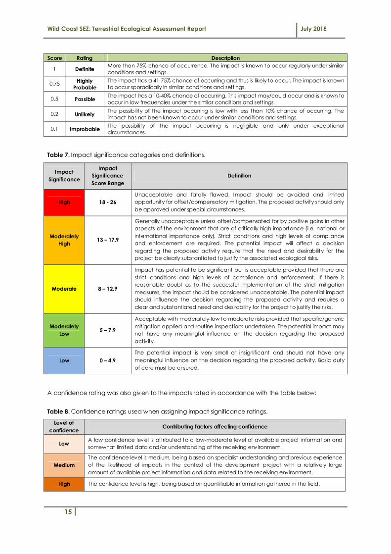
4 BASELINE VEGETATION & HABITAT ASSESSMENT 30
4.1 Vegetation Community Description & Condition Assessment .......................................................... 30
4.1.1 Mthatha Moist Grassland (Slightly Modified) 31
4.1.2 Degraded Secondary Grassland (Seriously Modified) 33
4.2 Ecological Importance & Sensitiv ity (EIS) Assessment ......................................................................... 35
5 ECOLOGICAL IMPACT ASSESSMENT 37
5.1 Proposed Development Context............................................................................................................ 37
5.2 Impact Identification and Description ................................................................................................... 38
Impact 1: Direct physical destruction of flora and fauna 39
Impact 2: Degradation and fragmentation of habitat 40
Wild Coast SEZ: Terrestrial Ecological Assessment Report July 2018
x
Impact 3: Pollution of soil, water and vegetation 42
Impact 4: Nuisance Factors (Noise, Vibrations, Light) 43
5.3 Impact Significance .................................................................................................................................. 44
5.3.1 Ecological Impact Significance Assessment 44
5.3.2 Contextualising Ecological Impact Significance 46
6 IMPACT MITIGATION & MANAGEMENT 49
6.1 Introduction................................................................................................................................................. 49
6.2 Approach to Impact Mitigation: ‘The Mitigation Hierarchy’ ............................................................ 49
6.3 Implementation of Mitigation Measures................................................................................................ 51
6.4 Development Planning: Env ironmental Guidelines and Principles................................................... 52
6.4.1 Avoid or restrict transformation of primary grassland 52
6.4.2 Plant Rescue and Translocation 52
6.4.3 Biodiversity Buffer Zones 54
6.4.4 Storm Water Management & Erosion Control 54
6.4.5 Wastewater Management 54
6.5 Construction-Phase Impact Mitigation & Management.................................................................... 54
6.6 Post-Construction Rehabilitation Guidelines (disturbed terrestrial habitat) .................................... 57
6.7 Operational-Phase Impact Mitigation & Management ..................................................................... 60
6.8 General Ecological Monitoring Requirements ..................................................................................... 62
7 BIODIVERSITY OFFSET REQUIREMENTS 65
7.1 National and Regional Guidance on Biodiversity Offsetting ............................................................. 65
7.2 Impact significance contextualised ....................................................................................................... 66
7.3 Preliminary assessment of the need for wetland offsets ..................................................................... 66
7.4 Preliminary offset recommendations ..................................................................................................... 67
8 CONCLUSION 68
9 REFERENCES 70
10 ANNEXURES 72
ANNEXURE A: Plant Species List
ANNEXURE B: Impact Significance Assessment Tables

Wild Coast SEZ: Terrestrial Ecological Assessment Report July 2018
xi
LIST OF FIGURES
Figure 1 Google EarthTM map showing the location of proposed Wild Coast SEZ at Mthatha Airport
within the King Sabata Dalindyebo Local Municipality, Eastern Cape. ............................................................ 1
Figure 2 Map showing the northern and southern land portions associated with the Phase 1
development. ............................................................................................................................................................... 2
Figure 3 Graph showing the relationship between population size and extinction risk, distinguishing
between the various species threat statuses (after SANBI, 2010). ...................................................................... 8
Figure 4 Conceptual diagram showing the approach to unpacking ecological impact significance. .. 12
Figure 5 National vegetation map (Mucina & Rutherford, 2006) showing the project area and two (2)
national vegetation types identified: Eastern Valley Bushveld (LT) and Mthatha Moist Grassland (EN). .. 19
Figure 6 Map showing the location and extent of Terrestrial CBAs in relation to the proposed WCSEZ
development identified according to the Eastern Cape Biodiversity Conservation Plan (Berliner &
Desmet, 2007). ............................................................................................................................................................ 20
Figure 7 Map showing the location and extent of the ‘Nduli Luchaba Nature Reserve’ (Prov incial
Protected Area) in relation to the project area at Umthatha Airport (Source: Eastern Cape Biodiversity
Conservation Plan - Berliner & Desmet, 2007). ..................................................................................................... 21
Figure 8 Map showing the location of Important Bird Areas (IBAs) in relation to the project area at
Umthatha Airport (source: BirdLife South Africa). ................................................................................................ 22
Species of conservation concern refer to species of flora (plants) and fauna (animals) that have a high
level of conservation importance in terms of preserv ing South Africa's high biological diversity and
include threatened species that have been classified as ‘at high risk of extinction in the wild’. .............. 22
Figure 9 Map showing the two terrestrial vegetation communities surveyed for the northern and
southern properties. ................................................................................................................................................... 30
Figure 10 Proposed land uses and serv ices infrastructure development layout plan for Phase 1 of the
WC: SEZ (Source: Coega Development Corporation). ...................................................................................... 38
Figure 11 Conceptual diagram showing the range of typical negative ecological consequences for
terrestrial ecosystems resulting from typical direct and indirect anthropogenic impacts. .......................... 45
Figure 12 Diagram illustrating the ‘mitigation hierarchy’ (after DEA et al., 2013). ......................................... 50
Map showing the location of Gladiolus ecklonii specimens located in the field (‘red’ Figure 13
stars). 53

Wild Coast SEZ: Terrestrial Ecological Assessment Report July 2018
xii
LIST OF TABLES
Table 1. South African Red List Categories for species of conservation significance (after SANBI, on-line
at http://redlist.sanbi.org/eiaguidelines.php). ....................................................................................................... 7
Table 2. Generic matrix used for the estimation and rating of flora/fauna species potential occurrence
based on known habitat requirements/preferences and ranges...................................................................... 9
Table 3. Description and indicators of Ecological Condition Classes. ............................................................... 9
Table 4. Generic matrix used for the estimation of habitat sensitiv ity and importance based on the joint
consideration of habitat condition and threat status of the vegetation type............................................... 11
Table 5. Descriptions of the EIS ratings used for terrestrial habitat. ................................................................... 11
Table 6. Criteria and numerical values for rating env ironmental impacts. ..................................................... 13
Table 7. Impact significance categories and definit ions. .................................................................................. 15
Table 8. Confidence ratings used when assigning impact significance ratings. ........................................... 15
Table 9. Key biophysical setting details of the study area. ................................................................................ 17
Table 10. Key conservation context summary details for the study area........................................................ 17
Table 11. Flora of conservation significance potentially occurring in the project area according to
SANBI’s POSA online database for the quarter degree 3128DA. ..................................................................... 22
Table 12. Potential occurrence of mammal species within the study area. .................................................. 24
Table 13. Summary of the potential occurrence of bird species of conservation concern within the study
area. ............................................................................................................................................................................. 26
Table 14. Summary of reptile species of conservation significance potentially occurring in the study
area. ............................................................................................................................................................................. 27
Table 15. Summary of the potential occurrence of amphibian species within the study area. ................. 29
Table 16. Summary of EIS assessment results. ........................................................................................................ 36
Table 17. Summary of construction and operation phase terrestrial ecological impact significance
ratings........................................................................................................................................................................... 45
Table 18. Basic information on Gladiolus ecklonii. ............................................................................................... 53
Table 19. Description of basic v isual monitoring requirements to assess the success of areas
rehabilitated. .............................................................................................................................................................. 63
Table 20. Summary guideline for evaluating the success of rehabilitation. .................................................... 64

Wild Coast SEZ: Terrestrial Ecological Assessment Report July 2018
xiii
LIST OF TERMS
Conservation The safeguarding of biodiversity and its processes (often referred to as Biodiversity
Conservation).
Ecosystem
An ecosystem is essentially a working natural system, maintained by internal ecological
processes, relationships and interactions between the biotic (plants & animals) and the
non-liv ing or abiotic environment (e.g. soil, atmosphere). Ecosystems can operate at
different scales, from very small (e.g. a small wetland pan) to large landscapes (e.g. an
entire water catchment area).
Ecosystem Goods
and Services
The goods and benefits people obtain from natural ecosystems. Various different types of
ecosystems provide a range of ecosystem goods and services. Aquatic ecosystems such
as rivers and wetlands provide goods such as forage for livestock grazing or sedges for craft
production and services such as pollutant trapping and flood attenuation. They also
provide habitat for a range of aquatic biota.
Erosion (gully)
Erosion is the process by which soil and rock are removed from the Earth's surface by
natural processes such as wind or water flow, and then transported and deposited in other
locations. While erosion is a natural process, human activities have dramatically increased
the rate at which erosion is occurring globally. Erosion gullies are erosive channels formed
by the action of concentrated surface runoff.
Function/functioning/
functional
Used here to describe natural systems working or operating in a healthy way, opposed to
dysfunctional, which means working poorly or in an unhealthy way.
Habitat The general features of an area inhabited by animal or plant which are essential to its
survival (i.e. the natural “home” of a plant or animal species).
Indigenous Naturally occurring or “native” to a broad area, such as South Africa in this context.
Invasive alien species
Invasive alien species means any non-indigenous plant or animal species whose
establishment and spread outside of its natural range threatens natural ecosystems,
habitats or other species or has the potential to threaten ecosystems, habitats or other
species.
Mitigate/Mitigation
Mitigating impacts refers to reactive practical actions that minimize or reduce in situ
impacts. Examples of mitigation include “changes to the scale, design, location, siting,
process, sequencing, phasing, and management and/or monitoring of the proposed
activity, as well as restoration or rehabilitation of sites”. Mitigation actions can take place
anywhere, as long as their effect is to reduce the effect on the site where change in
ecological character is likely, or the values of the site are affected by those changes
(Ramsar Convention, 2012).
Risk A prediction of the likelihood and impact of an outcome; usually referring to the likelihood
of a variation from the intended outcome.
Threat Status
Threat status (of a species or community type) is a simple but highly integrated indicator of
vulnerability. It contains information about past loss (of numbers and / or habitat), the
number and intensity of threats, and current prospects as indicated by recent population
growth or decline. Any one of these metrics could be used to measure vulnerability. One
much used example of a threat status classification system is the IUCN Red List of
Threatened Species (BBOP, 2009).
Threatened
ecosystem
In the context of this document, refers to Critically Endangered, Endangered and
Vulnerable ecosystems.
Transformation
(habitat loss)
Refers to the destruction and clearing an area of its indigenous vegetation, resulting in loss
of natural habitat. In many instances, this can and has led to the partial or complete
breakdown of natural ecological processes.

Wild Coast SEZ: Terrestrial Ecological Assessment Report July 2018
xiv
LIST OF ABBREVIATIONS/ACRONYMS
CBA Critical Biodiversity Area
CR Critically Endangered (threat status)
DEA Department of Environmental Affairs (formerly DEAT)
EA Environmental Authorisation
ECO Environmental Control Officer
EIA Environmental Impact Assessment: EIA regulations promulgated under section 24(5) of NEMA
EIS Ecological Importance and Sensitiv ity
EMPr Environmental Management Programme
GIS Geographical Information Systems
GPS Global Positioning System
IAPs Invasive Alien Plants
NEMA National Environmental Management Act No.107 of 1998
SANBI South African National Biodiversity Institute
VU Vulnerable (threat status)

Wild Coast SEZ: Terrestrial Ecological Assessment Report July 2018
1
1 INTRODUCTION
1.1 Project Locality and Description
The Coega Development Corporation (CDC) intends to develop the Wild Coast Special Economic
Zone (SEZ), located immediately adjacent to the existing Mthatha Airport north-west of Mthatha town
(Figure 1) in the Eastern Cape Prov ince of South Africa. Given the economic development potential
and agricultural focused advantages the region offers, and using input received during the
stakeholder’s consultation, developmental priorities were identified for phase 1 of the development.
Figure 1 Google EarthTM map showing the location of proposed Wild Coast SEZ at Mthatha Airport within the King Sabata Dalindyebo Local Municipality, Eastern Cape.
Based on available information received, the CDC is seeking Env ironmental Authorisation (EA) for
Phase 1 of a broader concept, namely the industrial-commercial type development within the
Mthatha Airport precinct. The two properties to be developed are shown outlined in ‘yellow’ in Figure
2:
• The Phase 1: ‘North’ property is 183 ha in extent and is located on the farm to the immediate
north of the existing Mthatha Airport runway. The intended development will be for agricultural
land use on the majority (164ha) of this property.
• The Phase 1: ‘South’ property is 72 ha in extent and is located on the farm to the immediate
south of the existing Mthatha Airport building. The intended development will be for a ‘mixed-
use’ type development comprising: hotel & conferencing, commercial space, industrial land
use and intensive agriculture & business process outsourcing.

Wild Coast SEZ: Terrestrial Ecological Assessment Report July 2018
2
Figure 2 Map showing the northern and southern land portions associated with the Phase 1 development.
1.2 Scope of Work
The terrestrial ecological assessment was undertaken in accordance with the following scope of works:
1. Desktop level mapping of untransformed terrestrial habitat and vegetation.
2. Rev iew of any documented and available studies/information for the site and surrounding
areas.
3. Contextualization of the study area in terms of important biophysical characteristics and
conservation planning using available spatial datasets and conservation plans including:
i. National Vegetation Types (Mucina & Rutherford, 2006);
ii. Available faunal species records/atlases for the study area;
iii. Plants of Southern Africa (POSA) database records for the study area (SANBI); and
iv . Eastern Cape Biodiversity Conservation Plan (Hayes et al., 2007).
4. Desktop assessment of the floral and faunal species of conservation concern that may occur
within the development footprint based on available species records for the region (e.g. POSA
database, SABAP2, Red Data Lists, etc.).
5. Undertaking a site walkover and field survey of the development zone to record necessary
information required to assess vegetation condition and the ecological importance and

Wild Coast SEZ: Terrestrial Ecological Assessment Report July 2018
3
sensitiv ity (EIS) of mapped untransformed grassland communities as well as habitat suitability for
key species such as Crowned Cranes:
i. Field survey of vegetation and habitat along transects across the untransformed
terrestrial (grassland) habitat types within the study area (included species
identification and status, relative abundance of different species, identification of
pioneer and alien plant species and description of habitat and vegetation type and
ecological condition rating).
ii. Identification and mapping of the geographic location of any terrestrial species of
conservation concern (rare/protected plants) noted during the site assessment.
iii. Basic day-time survey to further validate the potential occurrence of fauna of
conservation concern potentially occurring in the area (where possible) using v isual
observations of species as well as ev idence of their occurrence on the site (e.g.
burrows, nests, excavations, animal tracks, etc.).
6. Undertaking an assessment of the condition of the vegetation communities based on key
variables including species composition, vegetation structure and the presence of ruderal,
pioneer and invasive alien species.
7. Undertaking an assessment of the ecological importance and sensitiv ity of vegetation types
based on key criteria such as threat status, presence of red data species or suitability to
support key species of conservation significance, habitat condition, etc.
8. Identification and mapping of the geographic location of all plant/animal species of
conservation concern (i.e. threatened or protected plants/trees) recorded during the site
survey.
9. Compilation of plant species lists for the delineated vegetation communities.
10. Prov ision of an ecological sensitiv ity map for the site, including the location of sensitive
habitat/vegetation types, protected plants and wildlife and any recommended terrestrial
biodiversity buffer zones (development set-backs) with motivation to be prov ided.
11. Undertaking the identification, description and impact significance assessment for all potential
construction and operational phase impacts of the development on terrestrial biodiversity.
12. Prov ision of planning and design mitigation / recommendations to avoid and/or minimise
direct and indirect impacts where possible, including suitable biodiversity conservation buffer
zones.
13. Prov ision of construction and operational phase mitigation measures to remediate potential
impacts linked with the proposed development.
14. Discussion of any biodiversity offset requirements (where deemed relevant or desirable for the
project).
15. Discussion of any permit/licensing requirements that may be relevant to the site (i.e. protected
plant species permits).
16. Describe any assumptions, uncertainties or gaps in knowledge, as well as identifying the need
for any future specialist inputs should these be deemed relevant to the project.

Wild Coast SEZ: Terrestrial Ecological Assessment Report July 2018
4
1.3 The Importance of Biodiversity and Conservation
The term ‘biodiversity’ is used to describe the wide variety of plant and animal species occurring in their
natural env ironment or ‘habitat’. Biodiversity encompasses not only all liv ing things, but also the series
of interactions that sustain them, which are termed ‘ecological processes’. South Africa ranks as the
third most biologically diverse country in the world, based on an index of species diversity and
endemism, and is one of twelve (12) “mega-diverse” countries which collectively contain more than
two-thirds of global biodiversity (Endangered Wildlife Trust and DEA et al., 2013). South Africa’s
biodiversity is considered important for the following reasons:
• It prov ides an important basis for economic growth and development;
• Keeping our biodiversity intact is v ital for ensuring the on-going prov ision of ecosystem serv ices
that are if benefit to society, including the prov ision of clean air, water, food, medicine and
fibre;
• The role of biodiversity in combating climate change is also well recognised and further
emphasises the key role that biodiversity management plays on a global scale (Driver et al.,
2012);
• It plays an important role in addressing South Africa’s priorities of sustainable rural communities,
serv ice delivery and job creation; and
• Biodiversity forms the foundation of ecological infrastructure (ecosystems or habitats which
deliver the ecosystem serv ices that underpin economic and social development and are
increasingly recognised as hav ing market value).
We need to be mindful of the fact that without the integrity of our natural systems, there will be no
sustained long-term economic growth or life (DEA et al., 2013). Pressures and threats to biodiversity are
increasing globally and the continuous decline in biodiversity loss may have damaging consequences
in terms of local opportunity cost such as the production of clean water, carbon storage to counteract
global warming, etc. The loss of biodiversity puts aspects of the economy, wellbeing and quality of life
at risk, and reduces long-term socio-economic options for future generations. The need to sustain
biodiversity is directly or indirectly referred to in a number of Acts, with the most important being the
National Env ironmental Management: Biodiversity Act No. 10 of 2004 (NEM: BA). In terms of NEM: BA,
sustainable development requires the consideration of all relevant factors including disturbance of
ecosystems and loss of biodiversity, both of which should be avoided or, if that is not possible, should be
minimized and remedied. Given the limited resources available for biodiversity management and
conservation in South Africa, as well as the need for development, efforts to manage and conserve
biodiversity need to be strategic, focused and support the notion of sustainable development.
1.4 Overview of Relevant Environmental Legislation
The link between ecological integrity of ecosystems and their continued provision of valuable
ecosystem goods and serv ices to burgeoning populations is well-recognised, both globally and
nationally (Rivers-Moore et al., 2007). A strong legislative framework which backs up South Africa’s
obligations to numerous international conservation agreements creates the necessary enabling legal

Wild Coast SEZ: Terrestrial Ecological Assessment Report July 2018
5
framework for the protection of the countries natural resources and ecosystems. Relevant
env ironmental legislation pertaining to the protection and use of terrestrial ecosystems in South Africa
has been included below:
South African Constitution 108 of 1996
This includes the right to have the environment protected through legislative or other means.
National Environmental Management Act 107 of 1998
This is a fundamentally important piece of legislation and effectively promotes sustainable development and entrenches principles such as the ‘precautionary
approach’, ‘polluter pays’, and requires responsibility for impacts to be taken throughout the life cycle of a project.
Environmental Impact Assessment (EIA) Regulations
New regulations have been promulgated in terms of Chapter 5 of NEMA and
were published on 4 December 2014 in Government Notice No. R. 32828. In addition, listing notices (GN 983-985) lists activities which are subject to an
environmental assessment.
National Environmental Management: Biodiversity Act No. 10 of 2004
The intention of this Act is to protect species and ecosystems and promote the
sustainable use of indigenous biological resources. It addresses aspects such as protection of threatened ecosystems and imposes a duty of care relating to listed
invasive alien plants.
Conservation of Agricultural Resources Act 43 of 1967
The intention of this Act is to control the over-utilization of South Africa’s natural
agricultural resources, and to promote the conservation of soil and water resources and natural vegetation.
Other pieces of legislation that may also be of some relevance include:
• The National Forests Act No. 84 of 1998;
• The Natural Heritage Resources Act No. 25 of 1999;
• The National Env ironmental Management: Protected Areas Act No. 57 of 2003;
• Minerals and Petroleum Resources Development Act No. 28 of 2002;
• National Forests Act No. 84 of 1998 (NFA);
• Decree No. 9 (Env ironmental Conservation) of 1992.

Wild Coast SEZ: Terrestrial Ecological Assessment Report July 2018
6
2 APPROACH & METHODS
2.1 Approach to the Assessment
The proposed WCSEZ development constitutes Listed Activ ities which appear in Listing Notice 2 of the
NEMA EIA Regulations (2014, as amended) and therefore is subject to a Scoping and Full EIA process.
Eco-Pulse Env ironmental Consulting Serv ices (referred to hereafter as “Eco-Pulse”) was appointed by
WSP to undertake the required Specialist Terrestrial Ecological Assessments to inform the Scoping and
Full EIA process for the project. The assessment was subdiv ided into two distinct phases as follows:
� Phase1: Scoping. The scoping phase of the assessment entailed desktop investigations and the
compilation of a scoping report which was prepared in January 2018. The intention of the
scoping process was to identify key ecological issues to focus on during the EIA Phase of the
project as well as establish Terms of Reference (plan of study) for the EIA Phase assessments.
The ecological scoping report highlighted the presence and extent of key sensitive terrestrial
ecosystems and sensitive vegetation/habitat/species. Furthermore it also highlighted significant
impacts anticipated to key ecosystems.
� Phase 2: Detailed EIA Phase. This phase entailed undertaking a detailed Terrestrial Ecological
Baseline and Impact Assessment with detailed impact mitigation and management, in order to
comply with the minimum requirements of Appendix 6 of the NEMA: EIA Regulations (2014).
2.2 Methods
2.2.1 Field Survey
The field survey was undertaken over a 3-day period between 6 – 8 March 2018 (summer season). Mr
Dav id Styles, an experienced botanist, was present to assist with the identification of cryptic/rare plants
and compile a brief vegetation description of the identified vegetation communities. The survey
entailed a site walkover of key sections of the study area. Sampling was focused within the
development property. The following information was collected in the field:
• Identification and recording of plant species to inform vegetation community species
composition. Where plant species could not be identified, samples and photographs were
taken to confirm at a later stage using available taxonomic keys and species identification
guides.
• Qualitative species abundance.
• Location of any plant species of conservation concern.
• Observable onsite impacts.
• Distinct vegetation boundaries.
• Vegetation structure.
• Faunal habitat and visible signs of fauna (burrows, nests etc.)

Wild Coast SEZ: Terrestrial Ecological Assessment Report July 2018
7
Please note that sampling involved v isual /qualitative assessments and no formal vegetation plots were
undertaken. Furthermore, no formal faunal sampling or searches were undertaken and faunal features
such as dens, spoor1 and skat2 were recorded where identified but were not specifically sought out. All
sampling points were recorded using a handheld GPS dev ice.
2.2.2 Species of Conservation Concern: Potential of Occurrence (POC) Assessment
Species of conservation concern refer to species of flora (plants) and fauna (animals) that have a high
level of conservation importance in terms of preserv ing South Africa's high biological diversity and
include threatened species that have been classified as ‘at high risk of extinction in the wild’. If a
subpopulation of a species of conservation concern is found to occur on a proposed development
site, it would be one indicator that development activ ities could result in significant loss of biodiversity,
bearing in mind that loss of subpopulations of these species will either increase their extinction risk or
may in fact contribute to their extinction (see Figure 3). A description of the different SANBI categories
of species of conservation concern is prov ided in Table 1, below.
Table 1. South African Red List Categories for species of conservation significance (after SANBI, on-line
at http://redlist.sanbi.org/eiaguidelines.php).
Status Category Description
SP
EC
IES
OF
CO
NS
ERV
AT
ION
CO
NC
ERN
Critically Endangered,
Possibly Extinct (CR PE)
Possibly Extinct is a special tag associated with the category Critically Endangered,
indicating species that are highly likely to be extinct, but the exhaustive surveys
required for classifying the species as Extinct has not yet been completed. A small
chance remains that such species may still be rediscovered
Critically Endangered (CR)
A species is Critically Endangered when the best available evidence indicates that it
meets at least one of the five IUCN criteria for Critically Endangered, indicating that
the species is facing an extremely high risk of extinction.
Endangered (EN)
A species is Endangered when the best available evidence indicates that it meets at
least one of the five IUCN criteria for Endangered, indicating that the species is
facing a very high risk of extinction.
Vulnerable (VU)
A species is Vulnerable when the best available evidence indicates that it meets at
least one of the five IUCN criteria for Vulnerable, indicating that the species is facing
a high risk of extinction.
Near Threatened (NT)
A species is Near Threatened when available evidence indicates that it nearly meets
any of the IUCN criteria for Vulnerable, and is therefore likely to become at risk of
extinction in the near future.
INC
REA
SIN
G R
ISK
OF
EXTI
NC
TIO
N
Critically Rare
A species is Critically Rare when it is known to occur at a single site, but is not
exposed to any direct or plausible potential threat and does not otherwise qualify
for a category of threat according to one of the five IUCN criteria.
Rare
A species is Rare when it meets at least one of four South African criteria for rarity,
but is not exposed to any direct or plausible potential threat and does not qualify for
a category of threat according to one of the five IUCN criteria.
Declining
A species is Declining when it does not meet or nearly meet any of the five IUCN
criteria and does not qualify for Critically Endangered, Endangered, Vulnerable or
Near Threatened, but there are threatening processes causing a continuing decline
of the species.
Data Deficient -
Insufficient Information
(DDD)
A species is DDD when there is inadequate information to make an assessment of its
risk of extinction, but the species is well defined. Listing of species in this category
indicates that more information is required and that future research could show
that a threatened classification is appropriate.
1 Spoor is a track of an animal e.g. print made by hooves.
2 Skat is animal droppings.

Wild Coast SEZ: Terrestrial Ecological Assessment Report July 2018
8
Status Category Description
OT
HE
R
Data Deficient -
Taxonomically
Problematic (DDT)
A species is DDT when taxonomic problems hinder the distribution range and
habitat from being well defined, so that an assessment of risk of extinction is not
possible.
Least Concern (LC)
A species is Least Concern when it has been evaluated against the IUCN criteria and
does not qualify for any of the above categories. Species classified as Least Concern
are considered at low risk of extinction. Widespread and abundant species are
typically classified in this category.
Not Evaluated (NE)
A species is Not Evaluated when it has not been evaluated against the criteria. The
national Red List of South African plants is a comprehensive assessment of all South
African indigenous plants, and therefore all species are assessed and given a
national Red List status. However, some species included in Plants of southern
Africa: an online checklist are species that do not qualify for national listing because
they are naturalized exotics, hybrids (natural or cultivated), or synonyms. These
species are given the status Not Evaluated and the reasons why they have not been
assessed are included in the assessment justification.
Least Concern (LC)
Near Threatened (NT)]
Vulnerable (VU)
Endangered (EN)
Critically Endangered (CR)
Extinct in the Wild (EW)
EXTINCT (EX)
Figure 3 Graph showing the relationship between population size and extinction risk, distinguishing between the various species threat statuses (after SANBI, 2010).
A number of existing species databases, publications and field guides were used to assess the Potential
Occurrence (POC) of Red Data (Threatened/Protected) flora and fauna species for the study area and
development site, with following parameters were then used to assess the probability of occurrence:
1. Species range: Species often have specific geographical/altitudinal ranges in which they
occur or are restricted to and the location of the project area in relation to these distributional
ranges was evaluated based on available information.
2. Habitat requirements: Most Red Data animals have very specific habitat
requirements/preferences and the presence/absence of these habitat characteristics in the
study area was evaluated.
PO
PU
LAT
ION
SIZ
E
EXTINCTION RISK

Wild Coast SEZ: Terrestrial Ecological Assessment Report July 2018
9
3. Habitat status: Often a high level of habitat degradation in a specific habitat will negate the
presence of Red Species which are typically sensitive to disturbance; hence the status or
ecological condition/suitability of available habitat in the area was assessed.
4. Habitat connectivity: Movement between areas for breeding and feeding forms an essential
part of the life-cycle and persistence of many species. Isolated/patchy habitats are generally
not well-suited for harboring threatened species; however, this is not always the case.
Connectiv ity of the study area to surrounding habitat and the adequacy of these linkages
were evaluated.
The habitat requirements/preferences for each plant/animal t species of conservation concern was
thus reviewed (based on available literature) and was compared with the habitat occurring at the site
(initially based on imagery which was then verified through site v isits) in order to estimate the likelihood
of these species occurring on the target property (as per the assessment matrix in Table 2, below).
Table 2. Generic matrix used for the estimation and rating of flora/fauna species potential occurrence
based on known habitat requirements/preferences and ranges.
SPECIES HABITAT REQUIREMENTS/PREFERENCES
Fully met Largely met Partially met Not met
Natural condition
Fair condition Poor-Fair condition
Poor condition/ Transformed
SPEC
IES
DIS
TRIB
UTI
ON
/RA
NG
E
Habitat occurs within known species geographic/altitudinal
range
Highly probable
Possible Unlikely Highly unlikely or Improbable
Habitat occurs on the edge of known species
geographic/altitudinal range Possible Possible Unlikely
Highly unlikely
or Improbable
Habitat occurs outside of known species geographic/altitudinal
range Unlikely Unlikely
Highly unlikely or Improbable
Highly unlikely or Improbable
2.2.3 Assessment of Vegetation Community Ecological Condition
Vegetation communities / habitat units defined for the study area were assessed qualitatively in terms
of their ecological condition. Ecological condition is defined as a measure of modification relative to a
reference state in terms of species structure and composition. Table 3 below was used for providing a
description and indicators of each ecological condition class.
Table 3. Description and indicators of Ecological Condition Classes.
Condition Class
Description Indicators
Largely Intact Unmodified, largely natural.
• High native flora composition (80 – 100%).
• Structural characteristics resemble that of
reference plant communities.
• Low to no disturbances.
• Low to no weed and / or IAP infestation.
Slightly Modified / Transitional
Habitats where natural disturbance
regimes have changed resulting in a change to structural characteristics (e.g.
• Substantial increase in woody cover relative to
reference communities.
• High structural change.

Wild Coast SEZ: Terrestrial Ecological Assessment Report July 2018
10
Condition Class
Description Indicators
wooded grassland to a woodland community).
• Generally low to no disturbances.
• Generally low to no weed and IAP infestation.
Moderately Modified
A moderate change in species
composition and vegetation structure has occurred in response to
anthropogenic impacts.
• Moderate native flora composition (50 – 80%).
• Moderate change in structural characteristics
(e.g. moderate increase / decrease in woody plants) resemble that of reference plant
communities.
• Moderate disturbances.
• Moderate weed and / or IAP infestation.
Largely Modified / Degraded
A large to serious change in species composition and vegetation structure
has occurred in response to anthropogenic impacts.
• Low native flora composition (0 – 50%).
• Major change in structural characteristics relative to reference plant communities.
• High disturbance.
• Moderate to high weed and / or IAP
infestation.
Seriously Modified / Secondary
A vegetation community that replaces
original vegetation after severe disturbance (such as cultivation or
clearing) or severe cumulative impacts such as overgrazing or over-burning over
a long period of time.
• Vegetation comprised of few species, with
one or a few dominant.
• Moderate to high abundance of weeds and
IAPs.
• Contour ridges or other evidence of soil
disturbance evident.
Transformed Non-vegetated areas owing to past and
present human activities. A few indigenous species may be present.
• Present cultivated lands (crops, forestry, etc.).
• Developed land (Houses, Roads, etc.)
2.2.4 Assessment of Ecological Importance and Sensitivity (EIS)
Ecological Importance (EI) of a habitat type refers to the ability of the ecological entity to: (i) meet
conservation targets for conservation important flora and faunal species i.e. biodiversity maintenance
value; and (ii) prov ide for the maintenance of biodiversity features. The importance of each vegetation
community was therefore based on (i) whether it is representative of threatened habitat (condition), (ii)
whether it prov ides habitat for species of conservation concern, (iii) rarity, diversity and uniqueness of
flora and habitat and (iv ) its importance in terms of conservation planning.
Ecological Sensitivity (ES) refers to both the intensity and likelihood of change in key aspects as a result
of changes to key ecosystem drivers. The more sensitive a habitat or ecosystem, the more likely and
more intense the changes with a change in drivers. High sensitiv ity systems are those often
characterised by with high diversity, specifically sensitive species (intolerant species), small patch size
and/or low area to perimeter ratio and/or are located in areas sensitive to change e.g. located on
highly erodible soils or steep slopes. In terms of species, sensitive species are those with narrow
tolerance ranges and that cannot withstand elevated levels of disturbance. Low sensitiv ity systems are
often those characterised by low diversity, high levels of modification and can withstand elevated
disturbance regimes. Low sensitiv ity species are typically generalist and opportunistic species that have
wide tolerances ranges.

Wild Coast SEZ: Terrestrial Ecological Assessment Report July 2018
11
Table 4. Generic matrix used for the estimation of habitat sensitiv ity and importance based on the joint
consideration of habitat condition and threat status of the vegetation type.
HABITAT/VEGETATION IMPORTANCE & SENSITIVITY
Natural Good Fair Poor Very Poor/
Transformed
VEG
ETA
TIO
N
THR
EAT
STA
TUS
CRITICALLY ENDANGERED
High High High Moderate Low
Endangered High High Moderate Moderate Low
Vulnerable High High Moderate Low Low
Near Threatened Moderate Moderate Moderate Low Low
Least Threatened Moderate Moderate Low Low Very Low
Table 5. Descriptions of the EIS ratings used for terrestrial habitat.
EIS Rating Description
High Vegetation community with features are considered ecologically important and sensitive on a national or even international level.
Moderately-High Vegetation community with features are considered to be ecologically important and sensitive at a regional scale.
Moderate Vegetation community with features are considered to be ecologically important and sensitive at a local scale.
Moderately-Low Vegetation community with features are regarded as somewhat ecologically important and sensitive at a local scale.
Low Vegetation community with features that have a very low ecological importance and sensitiv ity at any scale.
2.2.5 Assessment of Ecological Impacts
Impact significance is defined broadly as a measure of the ‘desirability, importance and acceptability
of an impact to society’ (Lawrence, 2007). The degree of significance depends upon two dimensions:
the measurable characteristics of the impact (e.g. intensity, extent, duration) and the importance
societies/communities place on the impact. Put another way, impact significance is the product of the
value or importance of the resources, systems and/or components that will be impacted and the
intensity or magnitude (degree and extent of change) of the impact on those resources, systems
and/or components.
The significance of each impact was assessed in terms of the ultimate consequences (impacts to
resources of known societal value). The three ultimate consequences considered were:
i. Impacts to ecosystem conservation: Ecosystem conservation targets are determined at
national, provincial or local scales for known reference ecosystem and vegetation types, and
for the purposes of this assessment, not meeting or hindering the meeting of conservation
targets represents a significant societal impact. For this reason, impacts to ecosystem
conservation is seen as an important ultimate consequence that contextualises the
significance of impacts.
i. Impacts to direct benefits to humans: Impacts on direct benefits to humans relates primarily to
a loss of grazing, and access to harvestable goods such as medicinal plants and fuelwood
from prev iously accessible areas. The indirect effects of these impacts could negatively
influence the health and/ or livelihoods of beneficiaries.

Wild Coast SEZ: Terrestrial Ecological Assessment Report July 2018
12
ii. Impacts to species of conservation concern: Like ecosystem conservation targets, such targets
are also determined for biota. Impacts on populations of threatened biota is thus an important
ultimate consequence that contextualises the significance of impacts.
Figure 4 below shows how all four impacts were interpreted in terms of three possible ultimate
consequences.
Figure 4 Conceptual diagram showing the approach to unpacking ecological impact significance.
The significance of the potential impacts of the proposed development on terrestrial habitat was
assessed for the following scenarios:
i. Realistic “poor mitigation” scenario – this is a realistic worst case scenario involv ing the poor
implementation of construction mitigation, bare minimum incorporation of recommended
design mitigation, poor operational maintenance, and poor onsite rehabilitation.
ii. Realistic “good” scenario – this is a realistic best case scenario involv ing the effective
implementation of construction mitigation, incorporation of the majority of design mitigation,
good operational maintenance and successful rehabilitation. Please note that this realistic
scenario does not assume that unrealistic mitigation measures will be implemented and/or
measures known to have poor implementation success (>90% of the time) will be effectively
implemented.
For the purposes of this assessment, the assessment of potential impacts was undertaken using an
“Impact Assessment Methodology for EIAs” adopted by Eco-Pulse (2015). This assessment was informed
by baseline information contained in this report relating to the sensitiv ity of habitats and potential
occurrence of protected species as well as information on the proposed development prov ided by the
client and experience in similar projects in South Africa. The approach adopted is to identify and
predict all potential primary and secondary/indirect impacts resulting from an activ ity from origin (e.g.
Impacts
1. Direct physical habitat destruction and modification
2. Indirect erosion, sedimentation & pollution impacts
3. Impacts to biodiversity processes (connectiv ity)
4. Ecological disturbances and nuisance impacts
Ultimate Ecological Consequences
1. Impact on ecosystem
conservation
2. Impact on direct benefits to humans
3. Impacts to species of conservation
concern

Wild Coast SEZ: Terrestrial Ecological Assessment Report July 2018
13
catchment land hardening) to end point (e.g. loss of ecosystem serv ices as a result of erosion).
Thereafter, the approach is to rate intensity as the realistic worst case consequence (end-point /
ultimate) of an activ ity (according to Table 6) and then assess the likelihood of this consequence
occurring as well as the extent and duration of the impact.
Impact significance = (impact intensity + impact extent + impact duration) x impact likelihood.
This formula is based on the basic risk formula: Risk = consequence x probability
Table 6. Criteria and numerical values for rating environmental impacts.
Score Rating Description
Intensity (I) – defines the magnitude and importance of the impact
16 High
Loss of human life.
Deterioration in human health.
High impacts to resources:
� Critical / severe local scale (or larger) ecosystem modification/degradation and/or
collapse.
� Critical / severe local scale (or larger) modification (reduction in level) of ecosystem
services and/or loss of ecosystem services.
Critical / severe ecosystem impact description:
Impact affects the continued viability of the systems/components and the quality, use, integrity and functionality of the systems/components permanently ceases and are
irreversibly impaired (system collapse). Rehabilitation and remediation often impossible. If possible, rehabilitation and remediation often unfeasible due to extremely high costs of
rehabilitation and remediation.
� Extinction of habitat type or serious impact to future viability of a critically endangered
habitat type.
� Extinction of species or serious impact to survival of critically endangered species.
8 Moderately-
High
� Loss of livelihoods.
� Individual economic loss.
Moderately-high impacts to resources:
� Large local scale (or larger) ecosystem modification/degradation and/or collapse.
� Large local scale (or larger) modification (reduction in level) of ecosystem services and/or loss of ecosystem services.
Large ecosystem impact description:
Impact affects the continued viability of the systems/components and the quality, use, integrity and functionality of the systems/components are severely impaired and may
temporarily cease. High costs of rehabilitation and remediation, but possible.
� Measurable reduction in extent of endangered and critically endangered habitat
types.
� Measurable reduction in endangered and critically endangered floral and faunal
populations.

Wild Coast SEZ: Terrestrial Ecological Assessment Report July 2018
14
Score Rating Description
4 Moderate
Moderate impacts to resources:
� Moderate local scale (or larger) ecosystem modification/degradation and/or collapse.
� Moderate local scale (or larger) modification (reduction in level) of ecosystem services and/or loss of ecosystem services.
Moderate ecosystem impact description:
Impact alters the quality, use and integrity of the systems/components but the systems/ components still continue to function but in a moderately modified way (integrity and
functionality impaired but major key processes/drivers somewhat intact / maintained).
� Measurable reduction in vulnerable habitat types.
� Measurable reduction in non-threatened habitat types resulting in an up-listing to threatened status.
� Measurable reduction in near-threatened and vulnerable floral and faunal populations.
� Measurable reduction in non-threatened floral and faunal populations resulting in an up-listing to threatened status.
2 Moderately-
Low
Moderately-low impacts to resources:
� Small but measurable local scale (or larger) ecosystem modification / degradation.
� Small but measurable local scale (or larger) modification (reduction in level) of ecosystem services and/or loss of ecosystem services.
Small ecosystem impact description:
Impact alters the quality, use and integrity of the systems/components but the systems/ components still continue to function, although in a slightly modified way. Integrity, function
and major key processes/drivers are slightly altered but are still intact / maintained.
� Reduction in non-threatened endangered habitat types with no up-listing to threatened status.
� Reduction in non-threatened floral and faunal populations with no up-listing to threatened status.
1 Low
Negative change to onsite characteristics but with no impact on:
� Human life
� Human health
� Local resources, local ecosystem services and/or key ecosystem controlling variables
� Threatened habitat conservation/representation
� Threatened species survival
Extent (E) – relates to the extent of the Impact Intensity
5 Global The scale/extent of the impact is global/worldwide.
4 National The scale/extent of the impact is applicable to the Republic of South Africa
3 Regional Impact footprint includes the greater surrounding area within which the site is located (e.g. between 20-200km radius of the site).
2 Local Impact footprint extends beyond the cadastral boundary of the site to include the areas adjacent and immediately surrounding the site (e.g. between a 0-20km radius of the site).
1 Site Impact footprint remains within the cadastral boundary of the site.
Duration (D) – relates to the duration of the Impact Intensity
5 Permanent The impact will continue indefinitely and is irreversible.
4 Long-term The impact and its effects will continue for a period in excess of 30 years. However, the impact is reversible with relevant and applicable mitigation and management actions.
3 Medium-
term The impact and its effects will last for 10-30 years. The impact is reversible with relevant and applicable mitigation and management actions.
2 Medium-
short
The impact and its effects will continue or last for the period of a relatively long construction period and/or a limited recovery time after this construction period, thereafter it will be
entirely negated (3 – 10 years). The impact is fully reversible.
1 Short-term The impact and its effects will only last for as long as the construction period and will either
disappear with mitigation or will be mitigated through natural process in a span shorter than the construction phase (0 – 3 years). The impact is fully reversible.
Probability (P) – relates to the likelihood of the Impact Intensity
Wild Coast SEZ: Terrestrial Ecological Assessment Report July 2018
15
Score Rating Description
1 Definite More than 75% chance of occurrence. The impact is known to occur regularly under similar
conditions and settings.
0.75 Highly
Probable The impact has a 41-75% chance of occurring and thus is likely to occur. The impact is known
to occur sporadically in similar conditions and settings.
0.5 Possible The impact has a 10-40% chance of occurring. This impact may/could occur and is known to
occur in low frequencies under the similar conditions and settings.
0.2 Unlikely The possibility of the impact occurring is low with less than 10% chance of occurring. The
impact has not been known to occur under similar conditions and settings.
0.1 Improbable The possibility of the impact occurring is negligible and only under exceptional
circumstances.
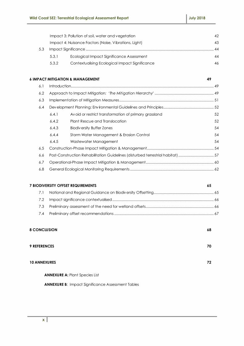
Table 7. Impact significance categories and definitions.
Impact
Significance
Impact Significance
Score Range
Definition
High 18 - 26
Unacceptable and fatally flawed. Impact should be avoided and limited
opportunity for offset/compensatory mitigation. The proposed activity should only
be approved under special circumstances.
Moderately High
13 – 17.9
Generally unacceptable unless offset/compensated for by positive gains in other
aspects of the environment that are of critically high importance (i.e. national or
international importance only). Strict conditions and high levels of compliance
and enforcement are required. The potential impact will affect a decision
regarding the proposed activity require that the need and desirability for the
project be clearly substantiated to justify the associated ecological risks.
Moderate 8 – 12.9
Impact has potential to be significant but is acceptable provided that there are
strict conditions and high levels of compliance and enforcement. If there is
reasonable doubt as to the successful implementation of the strict mitigation
measures, the impact should be considered unacceptable. The potential impact
should influence the decision regarding the proposed activity and requires a
clear and substantiated need and desirability for the project to justify the risks.
Moderately
Low 5 – 7.9
Acceptable with moderately-low to moderate risks provided that specific/generic
mitigation applied and routine inspections undertaken. The potential impact may
not have any meaningful influence on the decision regarding the proposed
activity.
Low 0 – 4.9
The potential impact is very small or insignificant and should not have any
meaningful influence on the decision regarding the proposed activity. Basic duty
of care must be ensured.
A confidence rating was also given to the impacts rated in accordance with the table below:
Table 8. Confidence ratings used when assigning impact significance ratings.
Level of
confidence Contributing factors affecting confidence
Low A low confidence level is attributed to a low-moderate level of available project information and
somewhat limited data and/or understanding of the receiving environment.
Medium
The confidence level is medium, being based on specialist understanding and previous experience
of the likelihood of impacts in the context of the development project with a relatively large
amount of available project information and data related to the receiving environment.
High The confidence level is high, being based on quantifiable information gathered in the field.

Wild Coast SEZ: Terrestrial Ecological Assessment Report July 2018
16
2.3 Assumptions, Limitations and Gaps in the Information Presented
The following limitations and assumptions apply to this assessment:
• This report deals exclusively with a defined area and the extent of terrestrial habitat/ecosystems in
that area.
• The terrestrial ecological study focused on ‘terrestrial’ or dryland vegetation occurring within the
study area. Wetland/aquatic vegetation and habitats have not been included in this assessment
and are dealt with separately in the Specialist Wetland Assessment Report (Eco-Pulse, 2018, Report
No. EP341-02)
• Information used to inform the assessment was limited to desktop data and GIS coverage’s
available for the prov ince and district municipality at the time of the assessment.
• Sampling by its nature means that generally not all aspects of ecosystems can be assessed and
identified.
• With ecology being dynamic and complex, there is the likelihood that some aspects (some of
which may be important) may have been overlooked.
• A rapid site walkover assessment was used instead of formal vegetation plots and detailed
vegetation/habitat sampling and analyses methods. Therefore comments on species abundance
and dominance are based on the assessor’s opinion based on field observations.
• Field assessment was undertaken in the summer/growing season (March 2018) and therefore winter
flowering cryptic forbs may have been over-looked. The assessment therefore does not cover the
full seasonal variation in conditions in the area of study.
• The location of indiv idual specimens of protected plant species were recorded hand held GPS with
an accuracy of 3 – 5m.
• Information on the threat status of plants species was informed largely by the SANBI Threatened
Species Online database, which was assumed to be up to date and accurate at the time of
compiling this report. Any changes made after the compilation of the report are therefore not
covered.
• No detailed survey of fauna was conducted during this assessment. Any fauna documented in this
report are based on site observations during a limited time spent in the field and do not reflect the
overall faunal composition of the site. It is assumed that based on the nature of the project, that
faunal impacts are likely to be limited.
• The assessment of impacts and recommendation of mitigation measures was informed by the site-
specific ecological concerns arising from the vegetation field surveys and based on the assessor’s
working knowledge and experience with similar development projects.

Wild Coast SEZ: Terrestrial Ecological Assessment Report July 2018
17
3 DESKTOP ECOLOGICAL ANALYSIS
3.1 Regional & Local Biophysical Setting
A summary of key biophysical setting details of the study area and surrounds are presented in Table 9
below.
Table 9. Key biophysical setting details of the study area.
Biophysical Aspects Desktop Biophysical Details Source
Elevation a.m.s.l. >700m (amsl) Google EarthTM
Mean annual precipitation (MAP) 679.1mm/annum (Shulze, 1997)
Rainfall seasonality Late-summer (DWAF, 2007)
Mean annual temperature 16-20°C in July to 24-28°C in February (DWAF, 2007)
Potential Evaporation (mm) Mean Annual A-pan Equivalent
1674.7 mm/annum (Shulze, 1997)
Geology
Sedimentary units of the Tarkastad
Subgroup (Beaufort Group): comprising
red and greenish-grey mudstone and fine
to medium grained sandstone
National Geology
dataset
3.2 Conservation Context
Understanding the conservation context and importance of the study area and surrounds is important
to inform decision-making regarding the management of terrestrial ecosystems, habitats and
associated biodiversity in the area. In this regard, national, prov incial and regional conservation
planning information available was used to obtain an overv iew of the study site. Key conservation
context details of the project site and surrounds have been summarised in Table 10, below.
Table 10. Key conservation context summary details for the study area.
NATIONAL LEVEL CONSERVATION PLANNING CONTEXT
Conservation Planning Dataset
Relevant Conservation Feature
Location in Relation to Project Site
Conservation Planning Status
National Vegetation Types (Mucina &
Rutherford, 2006)
Ecosystem Threat Status NBA 2011
Eastern Valley Bushveld
(SVs6)
Untransformed vegetation within the portion north of
Umthatha Airport
Least threatened,
Nominally protected
Mthatha Moist Grassland
(Gs 14)
Untransformed vegetation within the portion north
and south of Umthatha Airport
Endangered
PROVINCIAL AND REGIONAL LEVEL CONSERVATION PLANNING CONTEXT
Conservation Planning Dataset
Relevant Conservation Feature Location in Relation to
Project Site Conservation Planning
Status
EC Terrestrial
Conservation Plan
(Berliner and Desmet,
2007)
Untransformed/Intact terrestrial grassland
Site and surrounds Critical Biodiversity Area 1
(CBA 1) and CBA 2

Wild Coast SEZ: Terrestrial Ecological Assessment Report July 2018
18
3.2.1 National Threatened Ecosystems & Vegetation Types
A national process has been undertaken to identify and list threatened ecosystems that are currently
under threat of being transformed by other land uses. The first national list of threatened terrestrial
ecosystems for South Africa was gazetted on 9 December 2011 (National Environmental Management:
Biodiversity Act or NEMBA: National list of ecosystems that are threatened and in need of protection,
December 2011). The purpose of listing threatened ecosystems is primarily to reduce the rate of
ecosystem and species extinction by preventing further degradation and loss of structure, function and
composition of threatened ecosystems (SANBI, 2011). The NEMBA prov ides for listing of threatened or
protected ecosystems, in one of four categories: crit ically endangered (CR), endangered (EN),
vulnerable (VU) or protected. There are four main types of implications of list ing ecosystems:
• Planning related implications which are linked to the requirement in the Biodiversity Act (Act 10
of 2004) for listed ecosystems to be taken into account in municipal IDPs and SDFs;
• Env ironmental authorisation implications in terms of NEMA and the EIA regulations;
• Proactive management implications in terms of the National Biodiversity Act; and
• Monitoring and reporting implications in terms of the Biodiversity Act.
According to the Threatened Ecosystem coverage for the country which was interrogated, the project
area and planned development site is located within the Eastern Valley Bushveld - SVs 6 (Least
Threatened) and Mthatha Moist Grassland Gs 14 (Endangered) (see Figure 5, below). The former
vegetation type is characterised by semi-deciduous savanna woodland-thicket mosaic, often
succulent and dominated by species of Euphorbia and Aloe; and the latter is characterised by a
species-poor, sour, wiry grassland with Eragrostis plana and Sporobolus africanus but when in good
condition is dominated by Themeda triandra.

Wild Coast SEZ: Terrestrial Ecological Assessment Report July 2018
19
Figure 5 National vegetation map (Mucina & Rutherford, 2006) showing the project area and two (2) national vegetation types identified: Eastern Valley Bushveld (LT) and Mthatha Moist Grassland
(EN).
3.2.2 Eastern Cape Biodiversity Conservation Plan (ECBCP)
The Eastern Cape Biodiversity Conservation Plan (ECBCP) (Hayes et al., 2007; Berliner & Desmet, 2007)
addresses the urgent need for integrative systematic conservation planning and capacity building for
land-use decision making in the Eastern Cape. The ECBCP is a systematic conservation plan that
identifies and spatially maps Critical Biodiversity Areas (CBAs) required for biodiversity persistence and
to inform protected area planning and rural land-use planning in the Prov ince. For successful
implementation of the ECBCP, the CBAs need to be incorporated at all levels of spatial development
planning.
The ECBCP maps the site as a Terrestrial Critical Biodiversity Area (CBA) level 1 2 (T2) (Figure 6), which
captures sections of near-natural landscape and the (potential) presence of representative
‘Endangered’ vegetation types (i.e. Mthatha Moist Grassland) identified through the systematic
conservation assessment. The central portion of the northern project area has been mapped as a CBA
at level 1 and has further been identified as a potentially important ecological corridor for the
movement of biota.

Wild Coast SEZ: Terrestrial Ecological Assessment Report July 2018
20
Associated land-use guidelines for CBA areas are in the form of Biodiversity Land Management Classes
(BLMCs) which set out the desired ecological state that an area should be kept in to ensure biodiversity
persistence. For terrestrial CBA areas, the desired state should be to ‘maintain biodiversity in near-
natural state with minimal loss of ecosystem integrity and no transformation of natural habitat should be
permitted’.
Figure 6 Map showing the location and extent of Terrestrial CBAs in relation to the proposed WCSEZ development identified according to the Eastern Cape Biodiversity Conservation Plan (Berliner
& Desmet, 2007).
The ECBCP also identifies the portion of land to the north of the project area (surrounding Mthatha
Dam) as a Prov incial Protected Area: Nduli Luchaba Nature Reserve (see extent and location shown in
Figure 6, below). This is an approximately 460ha provincial nature reserve which hosts a variety of
wildlife, with a series of wetlands and grasslands that support rare and threatened cycads and a wide
selection of birds including the rare ‘Stanley’s Bustard’ (Vulnerable threat status) and many wetland
birds (online source: http://www.mthathadam.co.za). There are no planned expansion areas for
national protected areas mapped in the area around Mthatha in terms of the latest National Protected
Areas Expansion Strategy (NPAES) spatial coverage (Figure 7).

Wild Coast SEZ: Terrestrial Ecological Assessment Report July 2018
21
Figure 7 Map showing the location and extent of the ‘Nduli Luchaba Nature Reserve’ (Prov incial Protected Area) in relation to the project area at Umthatha Airport (Source: Eastern Cape
Biodiversity Conservation Plan - Berliner & Desmet, 2007).
3.2.3 Important Bird Areas (IBAs)
The Important Bird Areas (IBA) Programme is one of Bird Life International's most important conservation
initiatives. The South African IBA Programme is coordinated by BirdLife South Africa, with the purpose
being the identification and protection of a network of conservation sites, at a bio geographical scale,
critical for the long-term v iability of naturally-occurring bird populations. Important Bird Areas (Cape
Vulture Colonies) have been identified within 50km of the project area (Figure 8) and are unlikely to be
of significance to this project.

Wild Coast SEZ: Terrestrial Ecological Assessment Report July 2018
22
Figure 8 Map showing the location of Important Bird Areas (IBAs) in relation to the project area at Umthatha Airport (source: BirdLife South Africa).
3.2.4 Species of Conservation Concern: Potential Occurrence (POC)
Species of conservation concern refer to species of flora (plants) and fauna (animals) that have a high
level of conservation importance in terms of preserv ing South Africa's high biological diversity and
include threatened species that have been classified as ‘at high risk of extinction in the wild’.
3.2.4.1 Flora POC
Interrogation of SANBI’s online threatened species database for the quarter degree grid square 3128DA
highlighted four (4) species for consideration (refer to Table 11, below). Of the species highlighted, only
two (2) were identified as being ‘possible’ to potentially occur within remaining untransformed/intact
grassland habitat in the project study area. The field survey did not identify any of these species
occurring within the grassland habitat on the properties assessed.
Table 11. Flora of conservation significance potentially occurring in the project area according to
SANBI’s POSA online database for the quarter degree 3128DA.
Species Name Threat Status
Description Major
Ecosystem
Habitat Preferences Potential
Occurrence (POC)

Wild Coast SEZ: Terrestrial Ecological Assessment Report July 2018
23
Species Name Threat Description Major Habitat Preferences Potential
Brachystelma caffrum3 VU Perennial.
Geophyte, succulent
Terrestrial
Moist grassland with a
preference for dolerite outcrops. Altitudinal range: 300-1600m.
Possible
Impatiens flanaganiae4 VU Perennial.
Herb Terrestrial
Scarp forest near waterfalls and
seepage areas. Altitudinal range: 10-150m.
Highly
Unlikely
Dioscorea brownii5 EN
Perennial. Geophyte,
herb, succulent
Terrestrial
Tall mistbelt and moist montane grassland, on high ground along forest margins, in rich,
red, dolerite soils. Altitudinal range: 650-1450m.
Unlikely
Crinum macowanii6 DECL Perennial.
Geophyte Terrestrial
Mountain grassland and stony slopes in hard dry shale, gravely
soil or sandy flats. Altitudinal range: 200-1650m.
Possible
Key to Species Threat Status: EN – Endangered VU – Vulnerable DECL – Declining
3.2.4.2 Fauna POC
Fauna of conservation significance for the study area were highlighted by investigating at a desktop
level:
(i) Biodiversity features and known faunal species for the Eastern Cape region highlighted in the
Eastern Cape Conservation Plan (Berliner & Desmet, 2007);
(ii) Species records found in the South African Bird Atlas Project (SABAP) database for the Region;
(iii) Available species records (ADU, 2013); and
(iv ) Professional experience regarding rare/threatened amphibian species, reptiles and small
mammals and their habitat requirements in eastern South Africa (KZN and EC).
A. Mammals
The potential occurrence of mammal species of conservation significance (i.e. Red data/Endangered
species) was assessed based on available distribution records and habitat requirements for these
species, with the outputs of the desktop POC survey summarised in Table 12. The lack of species-
specific habitat for most of the mammals listed in Table 12 greatly reduces the likelihood of their
occurrence at the site. The likelihood of occurrence of many of these species is further reduced by their
proximity to human activ ities. Larger mammal species have either been eradicated or have moved
away from the area due to high levels of human disturbance associated with human occupation in the
area as well as development and cultivation pressures, not to mention the impact of the perimeter
fence around the property in terms of restricting species movement onto the property.
3 Dold, A.P. & Victor, J.E. 2007. Brachystelma caffrum (Schltr.) N.E.Br. National Assessment: Red List of South African Plants version
2017.1. Accessed on 2018/01/18. 4 von Staden, L., Victor, J.E. & Cloete, E. 2006. Impatiens flanaganiae Hemsl. National Assessment: Red List of South African Plants
version 2017.1. Accessed on 2018/01/18
5 Abbott, A.T.D., Johnson, I.M., Grieve, G. & von Staden, L. 2016. Dioscorea brownii Schinz. National Assessment: Red List of South
African Plants version 2017.1. Accessed on 2018/01/18 6 Williams, V.L., Raimondo, D., Crouch, N.R., Cunningham, A.B., Scott-Shaw, C.R., Lötter, M., Ngwenya, A.M. & Brueton, V.J. 2016.
Crinum macowanii Baker. National Assessment: Red List of South African Plants version 2017.1. Accessed on 2018/01/18

Wild Coast SEZ: Terrestrial Ecological Assessment Report July 2018
24
Small mammal species are also extremely vulnerable to human impacts, poaching as well as dogs and
feral cats. It is therefore quite unlikely that the development site itself constitutes significant habitat for
any species of threatened mammal species as well as for mammal species in general. The dominant
small mammal species occurring within adjacent intact habitats are also likely to be limited to those
with one or more of the following traits:
� Have generally small range requirements and broad habitat requirements;
� Tolerance for human disturbance;
� Characterised by high reproductive and surv ival rates; and
� The ability to move easily between remaining untransformed vegetation patches.
Table 12. Potential occurrence of mammal species within the study area.
Species Name IUCN Status
Habitat Requirements/ Preferences (after Stuart & Stuart, 2007)
Distribution/ Range
Habitat requirements met at site?
Site within distribution/
range? POC
Reddish-grey Musk Shrew Crodidura cyanea
DD
Moist habitats but also
found in very dry terrestrial habitats. Show a
preference for dense, matted vegetation.
Widespread
in RSA Possible √ Possible
Aardwolf Proteles cristatus
Rare Preference for open
habitats and avoids heavily wooded areas and forest.
Widespread in RSA
Possible √
Unlikely
due to human
presence
and perimeter
boundary fences
African striped weasel Poecilogale
albinucha
DD
Moist grasslands with flourishing populations of
small rodents (their main food source). Soil texture
may be important as weasels often excavate their own burrows.
Eastern RSA Possible √
Brown hyaena Parahyaena brunnea
Rare Potentially wide
distributional tolerance (historically).
Northern
southern Africa
Possible √
Leopard Panthera pardus
Rare Extremely wide distributional tolerance (historically).
Northern RSA, NE Eastern
Cape, Western
Cape
X √ Highly
Unlikely
Blue duiker Cephalophus monticola
Rare Confined to forests and dense bush.
Western coastal RSA
X √ Highly
Unlikely
Honey badger Mellivora capensis
VU Most major habitats. Widespread
in RSA Possible √
Unlikely
due to human
presence
African Wild cat Felis silvestris lybica
VU Open, dry habitats. Widespread
in RSA Possible √
Unlikely
due to human
presence and
perimeter boundary

Wild Coast SEZ: Terrestrial Ecological Assessment Report July 2018
25
Species Name IUCN Status
Habitat Requirements/ Preferences (after Stuart & Stuart, 2007)
Distribution/ Range
Habitat requirements met at site?
Site within distribution/
range? POC
fences
Oribi Ourebia ourebi
VU Open short grassland with
taller patches for cover.
Southern
KZN, NE Eastern Cape
Possible X Highly
Unlikely
Cape clawless otter Aonyx capensis
NT
Unpolluted, un-silted
streams (though species is not adversely affected by
turbid waters) and rivers with good supply of food
(crabs) and dense riverine vegetation (long grass,
reeds, bushes) and other cover (holes, boulders).). Areas with dense reed beds
and a rocky substrate on banks are used most
intensively, probably on account of a localized high
food biomass. Impoundments, both large
and small, appear to be secondary (less suitable) habitat.
Eastern RSA X √ Highly
Unlikely
Serval Leptailurus
serval
NT
Servals enjoy with well-
watered habitats like grass savannas along river reed beds and swamps, in brush
and open woodlands and along the edge of forests.
Eastern RSA X √ Unlikely
Swinny’s Horseshoe Bat Rhinolophus swinnyi
EN
Found in moist montane rainforest, and dry and
moist savanna. Populations are dependent on caves,
mines and similar habitats for roosting. It appears to
be sparsely distributed in parts of its range.
Eastern part
of South Africa
X √ Unlikely
Sykes’ Monkey Cercepithecus albogularis
Rare High forest, forest margins and riverine gallery forest.
Eastern RSA X √ Highly
unlikely
Tree hyrax/dassie Dendrohyrax arboreus
Not evaluat
ed
Suitable forest and bush areas, including coastal
dune forest.
Central KZN, Eastern and
coastal EC
X √ Highly
unlikely
Giant golden mole Chrysospalax villoosus
Not evaluat
ed
Very patchy and limited
distribution, occurring only in relict areas of indigenous high forest.
Central KZN,
Eastern and coastal EC
X √ Highly
unlikely
Key to Species Threat Status: EN – Endangered, VU – Vulnerable, NT – Near Threatened, DD – Data Deficient

Wild Coast SEZ: Terrestrial Ecological Assessment Report July 2018
26
B. Avifauna (birds)
The South African Bird Atlas Project (SABAP) aims to map the distribution and relative abundance of
birds in southern Africa and relies heav ily on data uploaded by “citizen scientists”. Birds of
conservation concern were identified through use of the South African Bird Atlas Project (SABAP)
database (available online at http://sabap2.adu.org.za/). Information for the Quarter Degree Grid
Square (QDGS): 3128DB was used.
Whilst the majority of species recorded by the SABAP are considered locally common birds, there
are a number of bird species that are considered to be of conservation concern based on their
conservation/threat status (Table 13, below). The distributional ranges and habitat
requirements/preferences for each bird species of conservation concern was reviewed (based on
available literature) to estimate the likelihood of these species occurring within the study area. Based
on their habitat preferences and distributional range, five (5) birds of conservation concern could
possibly utilise the grassland and wetland habitat at the site and surrounds, including African marsh-
harrier (Circus ranivorus), Black-winged Lapwing (Vanellus melanopterus), Lesser Kestrel (Falco
naumanni), Grey Crowned Crane (Balearica regulorum) and Denham’s (Stanley’s) Bustard (Neotis
denhami) (Table 12):
� A pair of Grey-Crowned Crane (VU) was observed by the ecologists from Eco-Pulse in 2012
within the moist grassland adjacent to the wetlands on the site in the northern section of the
project area and probably exploit the site as the area is fenced and less vulnerable to
predators.
� Stanley’s Bustard (VU) is also known to occur within the grasslands within the adjacent
Luchaba Nature Reserve to the north, however due to the airport property being fenced-
off; it is quite unlikely that this bird species frequents the site.
Table 13. Summary of the potential occurrence of bird species of conservation concern within the study
area.
Species Name Status Habitat Preferences (after Chittenden, 2009; IUCN, 2016) POC
African Crowned Eagle
(Stephanoaetus coronatus) NT
Favours tall closed canopy forest, riparian forest, dense woodland and gorges. Also inhabits gum and pine
forestry plantations. Normally chooses tallest canopy tree to build large stick platform nest.
Highly
Unlikely
African marsh-harrier (Circus ranivorus)
VU Inland and coastal wetlands as well as adjacent moist grassland. Breeding demands a stretch of undisturbed
long grass with concealed clearings.
Possible
Black-winged Lapwing (Vanellus melanopterus)
NT
Breeds in short grassland a higher elevations and open
plains and dry savanna at lower altitudes. Frequents wastelands, cultivated or fallow fields, meadows, airfields,
coastal flats and golf courses during times of non-breeding.
Possible
Cape Vulture Gyps coprotheres
VU Flies long distances over open country, usually found near mountains, where it breeds and roosts on cliffs.
Highly Unlikely
Denham’s (Stanley’s) Bustard (Neotis denhami)
VU
Inhabits grasslands, grassy Acacia-studded dunes, fairly
dense shrubland, light woodland, farmland, crops, dried marsh and arid scrub plains
Known to be present
within the adjacent
Luchaba

Wild Coast SEZ: Terrestrial Ecological Assessment Report July 2018
27
Species Name Status Habitat Preferences (after Chittenden, 2009; IUCN, 2016) POC Reserve
but unlikelty to
frequent the
fenced-off
site
Grey Crowned Crane
(Balearica regulorum)
VU
Breeds in marshes, pans and dam margins with tall
emergent vegetation. Found in pairs during breeding season, roosting on the ground near nest in wetlands.
Feed in adjacent short to medium height grassland, wetlands and agricultural fields.
Possible (observed
by Eco-
Pulse in 2012)
Secretarybird (Sagittatius serpentarius)
NT Open grassland with scattered trees/shrubs. Unlikely
Southern Ground-Hornbill (Bucorvus leadbeateri)
VU Favours open woodland. Highly
Unlikely
Martial Eagle VU Mostly open savanna and woodland on plains. Unlikely
Lesser Kestrel (Falco naumanni)
VU Open savanna, grassland and verges of cultivated land. Possible
Key to Species Threat Status: VU – Vulnerable NT – Near Threatened
C. Reptiles
A number of endemic and near-endemic reptile species, including lizards, snakes and skinks, modelled
to occur in this region of the Eastern Cape and could potentially reside in the more intact grassland
and wetland/riverine habitats in the study area (Table 14, below).
No endangered species are likely to occur based on the data/literature consulted. All reptile species
are sensitive to major habitat alteration and fragmentation. As a result of human presence in the area
coupled with historic and still active agricultural disturbances, alterations to the original reptilian fauna
are expected to have already occurred, with remaining areas where anthropogenic impacts are
limited possibly hosting some of the species listed.
Table 14. Summary of reptile species of conservation significance potentially occurring in the study
area.
Species Name Threat Status
Habitat Requirements/ Preferences
(after Bates et al. 2014)
Distribution/ Range
Habitat requirements met at site?
Site within distribution/
range? POC
Bibron’s Blind Snake Afrotyphlops
bibronii
Near- Endemic
Grassland / savannah:
burrows in loose soil, common in old termitaria under rocks
and rotting logs.
Eastern RSA √ √ Possible
Cape Girdled Lizard Cordylus cordylus
Endemic
Rupicolous species,
occurring in diverse habitats from coastal
rocks to mountain tops.
Widespread across southern
RSA
Partial √ Unlikely
Cape Grass Lizard Chamaesaura
anguina anguina
Endemic
Found mostly on
mountain slopes in fynbos and grassland
habitats.
Widespread across RSA
Partial √ Unlikely
Cape Many-Spotted Snake Amplorhinus
Near- Endemic
Reed beds, vleis and
riverside vegetation, grassland and montane
Scattered
populations in east and south
√ √ Possible

Wild Coast SEZ: Terrestrial Ecological Assessment Report July 2018
28
Species Name Threat Status
Habitat Requirements/ Preferences
(after Bates et al. 2014)
Distribution/ Range
Habitat requirements met at site?
Site within distribution/
range? POC
multimaculatus forest. RSA
Common South African Slug Eater Duberria lut rix lutrix
Endemic
Favours damp localities in grassland, moist savanna, lowland forest
and fynbos.
Widespread across RSA
Partial √ Unlikely
Delalande’s Sandveld Lizard Nnucras lalandii
Endemic
Generally associated
with montane and temperate grassland,
takes shelter in underground burrows or
under rocks.
Widespread
across RSA. Partial √ Unlikely
Dusky-Bellied Water Snake Lycodonomorphu
s laevissimus
Endemic
Inhabits riverine and
other aquatic habits, particularly well-
wooded streams.
Eastern RSA X √ Unlikely
Eastern Ground Agama Agama aculeate
distanti
Endemic
Occurs in grassland and
woody habitats, occasionally in rocky
areas.
Widespread
across central and eastern
RSA
√ √ Possible
Eastern Cape Dwarf Chameleon Bradypodion
vent rale
Endemic
Considered a habitat generalist.
Southern and east Eastern
cape
Partial √ Unlikely
Forest Thread Snake Leptotyphlops sylvicolus
DD Subterranean, forest areas and montane
grassland.
Scattered in
central coastal KZN and
northern Eastern Cape
X √ Unlikely
KwaZulu-Natal Black Snake Macrelaps microlepidotus
NT
Semi-fossorial species, frequents moist leaf litter
and humic soil within forests and coastal
bush.
Eastern EC and
KZN X √ Unlikely
Kentani Dwarf Chameleon Bradypodion
kentanicum
VU Trees and bushes of coastal scarp forest.
Eastern Cape X √ Unlikely
Olive Ground Snake Lycodonomorphu
s inornatus
Endemic
Grassland, savannah, fynbos, forest.
Eastern parts of RSA
√ √ Possible
Pondo Flat Gecko Afroedura
pondolia
Endemic
Rupicolous species,
occurring on rock outcrops and cliffs in a
variety of wooded habitats.
Eastern EC and KZN
X √ Unlikely
Pondo Dwarf Chameleon Bradypodion caffer
EN Coastal forest. Few coastal
localities in EC. X √ Unlikely
Southern Brown Egg-Eater Dasypeltis inornata
Endemic
Prefers open coastal woodland and moist
savannah, shelters under rocks.
Eastern RSA X √ Unlikely
Southern Rock Agama Agama atra
Near- Endemic
Rocky habitats. Widespread in
RSA X √ Unlikely
Spotted Thick-Toed Gecko Pachydactylus
Near- Endemic
Broad range of habitats
but chiefly in mesic areas.
Southern and
eastern RSA √ √ Possible

Wild Coast SEZ: Terrestrial Ecological Assessment Report July 2018
29
Species Name Threat Status
Habitat Requirements/ Preferences
(after Bates et al. 2014)
Distribution/ Range
Habitat requirements met at site?
Site within distribution/
range? POC
maculatus
Spotted Rock Snake Lamprophis guttatus
Near- Endemic
Rocky areas. Scattered
across RSA Partial √ Possible
Spotted Harlequin Snake Homoroselaps lacteus
Endemic
Semi-fossorial species found in sandy
substrates, old termitaria and under rocks.
Widespread
across RSA Partial √ Unlikely
Variable Legless Skink Acontias poecilus
EN
Found in moist soil or under leaf litter in
forested habitats. Occurs from sea level up to 900 m in the
Eastern Cape.
Southern coastal
reaches of KZN and adjacent eastern parts
of EC.
X √ Unlikely
Western Natal Green Snake Philothamnus
natalensis occidentalis
Endemic
Occurs in lowland forest, wooded grassland and
forest edges.
Eastern and
southern RSA X √ Unlikely
Key to Species Threat Status: EN – Endangered, VU – Vulnerable, NT – Near Threatened, DD – Data Deficient
D. Amphibians
The study area has not been highlighted as a particularly important area for the conservation of
amphibian species such as frogs, with few known endemic or threatened species highlighted for the
project site. Amphibian species of conservation concern are unlikely to be present at the site or within
the surrounding aquatic habitats due to the lack of sutable habtiat prov ided for key species such as
the Endangereed Kloof Frog, Natalobatrachus bonebergi (Table 15).
Table 15. Summary of the potential occurrence of amphibian species within the study area.
Species Name Threat Status
Habitat Requirements/
Preferences (after IUCN, 2016)
Distribution/
Range
Habitat requirements met at site?
Site within distribution/
range? POC
Natalobatrachus
bonebergi
Kloof Frog
EN Coastal and densely forested kloofs, along
slow flowing streams.
Coastal KZN and EC X √
Highly unlikely
Afrixalus knysnae
Knysna Leaf-
Folding Frog
EN Small pans in grassland. Coastal NE EC X √ Unlikely
Leptopelis
natalensis
Forest tree frog
Endemic
Riverine bush and
swamp forest, coastal forest.
Coastal KZN
and NE coastal EC.
X √ Highly
unlikely
Key to Species Threat Status: EN – Endangered
Wild Coast SEZ: Terrestrial Ecological Assessment Report July 2018
30
E. Invertebrates
There is generally very little available long-term information on invertebrate species and populations for
most of South Africa, with no known available information on invertebrates for the study area to enable
the assessment of potential occurrence.
4 BASELINE VEGETATION & HABITAT ASSESSMENT
4.1 Vegetation Community Description & Condition Assessment
Following a walk-through site v isit conducted over a 3-day period in summer (March 2018), the
following terrestrial vegetation communities were identified for the site and surrounding area (shown
mapped in Figure 9):
1. Slightly Modified Primary Mthatha Moist Grassland: found exclusively on the northern property and
accounting for roughly 141 hectares (ha) of the property;
2. Degraded Secondary Grassland: found exclusively on the southern property and accounting for
roughly 45 hectares (ha) of the property.
Figure 9 Map showing the two terrestrial vegetation communities surveyed for the northern and southern properties.

Wild Coast SEZ: Terrestrial Ecological Assessment Report July 2018
31
A list of 90 plant species recorded in the mapped vegetation communities is prov ided as Annexure A of
this report.
Please note that freshwater wetland habitat (shown delineated in Figure 9) has not reported on in this
‘terrestrial ecological report’ but has been addressed in detail in the Specialist Wetland Assessment
report for the project (Eco-Pulse, 2018 ; Report no. EP341-02).
4.1.1 Mthatha Moist Grassland (Slightly Modified)
The Transkei region of the Eastern Cape has been settled and grazed for a long period of time.
Generally speaking, grasslands in proximity to human settlements and where there is or has been active
livestock grazing are frequently degraded and most often depleted of natural plant diversity, and very
often, only unpalatable grasses and weeds remain.
The grassland identified on the northern property (north of the Mthatha airfield runway) is quite unusual
in that it is primary in the sense that there is still some herbaceous and geophyte diversity. The (Slightly
Modified) Mthatha Moist Grassland was identified solely for the northern property and accounts for
roughly 141 ha of the site. Considering that weed and Invasive Alien Plant (IAP) infestation levels was
typically low and the structural integrity of the grassland was intact, it was concluded that the
grassland is slightly modified but not entirely representative of reference state. It is worth noting that the
condition assigned to this vegetation community is a condition class below largely intact or unmodified.
The Mthatha Moist Grassland is an ‘endangered’ vegetation type nationally (Mucina & Rutherford,
2006).
Noteworthy features and characteristics of this primary grassland community are:
• It is ev ident that fencing the Mthatha Airport Precinct has allowed the grassland to recover
from historic anthropogenic impacts such as overgrazing and poor veld management.
• The vegetation community was found to comprise a medium-tall grassland community
occurring exclusively on the crest and convex slopes of undulating lowlands within the northern
property.
• Concave and low-lying areas where identified as being wetland habitat.
• The Mthatha Moist Grassland comprised a relatively low diversity of tufted grasses and forb
species.
• A striking feature of the grassland was that it was dominated almost exclusively by Themeda
triandra (Red grass), a climax grass species typically found in good condition veld that has not
been overgrazed or heav ily disturbed (van Oudtshoorn, 2012). Although its abundance is cited
as an indicator of a grassland community in good condition and at a ‘climax’ successional
stage, in this case it is better described as a species that becomes abundant in under-utilized
grassland or veld that is not frequently burnt which is the case at the northern property.

Wild Coast SEZ: Terrestrial Ecological Assessment Report July 2018
32
• Hyparrhenia hirta, a species associated with disturbed sites, was found to be also abundant
albeit not at the same level as T. triandra. The abundance of H. hirta is likely to be linked with
historically poor veld management prior to fencing of the Mthatha Airport precinct. In the
absence of grazing and fire regime, it is expected that this grass species will decrease in
abundance with time.
• Forb diversity and abundance was found to be low, with usually 4 or fewer species
encountered per m2. In certain localised areas, forbs were not even recorded. Forbs recorded
included mainly ruderal* species and weeds common in grasslands occurring in summer rainfall
areas. Such species belong to families such as Asteraceae, Fabaceae, Apocynaceae,
Rubiaceae, Hyacinthaceae, Lamiaceae, Iridaceae and Scrophulariaceae. The most common
were identified as Chamaecrista mimosoides*, Crabbea hirsute Cyanotis speciosa,
Eriospermum sp. (not found in flower), Helichrysum nudifolium subsp. nudifolium*, Helichrysum
odoratissimum*, Hermannia parviflora, Lobelia flaccida, Pelargonium alchemilloides*, Vigna
vexillata* and Zornia capensis.
• There was no woody vegetation except for a minority and scattered presence of alien invasive
species (principally Acacia mearnsii, Black-Wattle).
• Whilst no red listed plants were identified, a rare plant species not usually found in the Mthatha
area, Periglossum mackenii, was recorded. Prov incially protected plant species were also not
recorded. Although not recorded, there is a strong likelihood that Kniphofia species may be
present particularly in wet habitats. These are conspicuous in flower but being grass-like in
growth form may be inconspicuous or invisible amongst grasses when not in flower which
explains why they may not have been recorded during the site survey.
• The grassland in the env ironments of Mthatha beyond the fenced airport precinct is heav ily
grazed, apparently very frequently burned, dominated by Aristida junciformis and other wiry,
unpalatable grasses, and has been mostly ev iscerated of herbaceous plant diversity except for
species that are unpalatable or toxic to cattle and goats. Some of this grassland has also been
historically cultivated.

Wild Coast SEZ: Terrestrial Ecological Assessment Report July 2018
33
Photo 1: View of the slightly modified primary grassland (Mthatha Moist Grassland) occurring on the northern
property, with the mid-slope section covered by the climax grass species, Themeda triandra.
Photo 2: Disturbed vegetation community along the edge of the Mthatha Moist Grassland. This area is
subject to frequent mowing.
Photo 3: Bulbine sp. recorded within the Mthatha Moist Grassland.
4.1.2 Degraded Secondary Grassland (Seriously Modified)
The Secondary Degraded Grassland found exclusively on the smaller southern property comprises a
45ha medium-tall grassland community occurring on the upper portion of a north-facing slope within
the southern property. The grassland was assigned as ‘secondary’ status as the property had been
historically cultivated and transformed for rural infrastructure such as homesteads. Following cessation
of cultivation, relocation of locals and fencing of the property, a mixed secondary grassland
community has become established through a natural successional process. Given abovementioned

Wild Coast SEZ: Terrestrial Ecological Assessment Report July 2018
34
impacts and present vegetation status (structurally and compositionally), the Degraded Secondary
Grassland has been assigned a condition class of seriously modified. In other words, the vegetation
community is highly dissimilar to the reference Mthatha Moist Grassland. Although this may be an
instance of Mthatha Moist Grassland, as nearly all appears to be old cultivated land and to have been
transformed or severely degraded, it is not considered very valuable from a plant diversity perspective.
The vegetation is certainly less valuable than most of that occurring on the northern property by
comparison.
Noteworthy features and characteristics of this primary grassland community are:
• The grassland comprised a low diversity of tufted grasses and forbs. Hyparrhenia dregeana
and H. hirta were found to be most dominant. T. triandra was observed to be uncommon and
this likely attributed to the exclusion of disturbance regimes which allowed it to spread.
• Forbs were observed to be limited to a few weeds and ruderals. The species composition was
similar to the recorded in the Mthatha Moist Grassland (described above) with the exception
of the presence of Monopsis unidentata, a species that flourishes in damp, disturbed areas.
• The Secondary Degraded Grassland was found not to host red-listed or rare plants but offered
refuge to a prov incially protected forb, Gladiolus ecklonii. Should their habitat be transformed,
these protected plant species will need to be translocated prior to commencement of
construction. A plant permit will be required from the Eastern Cape Department of Economic
Development, Env ironmental Affairs and Tourism (DEDEAT).
• Despite the vegetation community being in an early successional stage of recovery, there
were still major anthropogenic impacts present at the site, albeit in localised areas. These
included habitat transformation to establish greenhouse infrastructure, small-scale potato and
maize cultivation and a leaking water pipeline which has created an artificial wetland habitat
in an areas otherwise would have been terrestrial. The legacy of human habitation was still
ev ident in the form of concrete slabs and hardened surfaces which has had a restrictive effect
on natural vegetation establishment.
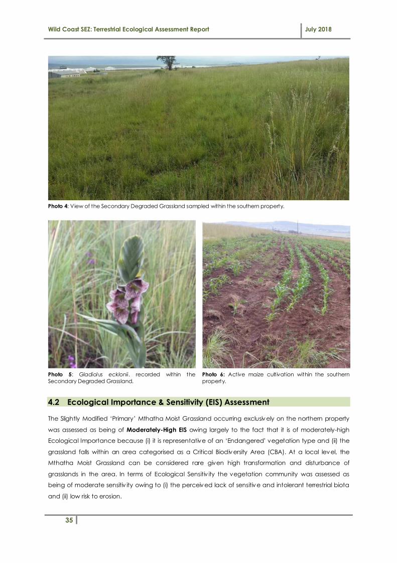
Wild Coast SEZ: Terrestrial Ecological Assessment Report July 2018
35
Photo 4: View of the Secondary Degraded Grassland sampled within the southern property.
Photo 5: Gladiolus ecklonii. recorded within the
Secondary Degraded Grassland.
Photo 6: Active maize cultivation within the southern
property.
4.2 Ecological Importance & Sensitivity (EIS) Assessment
The Slightly Modified ‘Primary’ Mthatha Moist Grassland occurring exclusively on the northern property
was assessed as being of Moderately-High EIS owing largely to the fact that it is of moderately-high
Ecological Importance because (i) it is representative of an ‘Endangered’ vegetation type and (ii) the
grassland falls within an area categorised as a Critical Biodiversity Area (CBA). At a local level, the
Mthatha Moist Grassland can be considered rare given high transformation and disturbance of
grasslands in the area. In terms of Ecological Sensitiv ity the vegetation community was assessed as
being of moderate sensitiv ity owing to (i) the perceived lack of sensitive and intolerant terrestrial biota
and (ii) low risk to erosion.

Wild Coast SEZ: Terrestrial Ecological Assessment Report July 2018
36
The Degraded Secondary Grassland occurring exclusively on the southern property was assessed as
being of Low EIS. Although it is not representative of its benchmark vegetation type, the Secondary
Degraded Grassland is located within a Critical Biodiversity Area 2. In terms of Ecological Sensitiv ity the
vegetation community was assessed as being of moderately-low sensitiv ity owing to (i) the lack of
sensitive and intolerant terrestrial biota and (ii) low risk to erosion.
Table 16. Summary of EIS assessment results.
Terrestrial Vegetation Community
Reference Vegetation Type (Mucina & Rutherford, 2006)
Provincial Threat Status
(ECBCP) Condition
Ecological Sensitivity and
Importance
1. Primary Grassland Mthatha Moist
Grassland ‘Endangered’
Slightly modified, representative
Moderately-High
2. Secondary Grassland Mthatha Moist
Grassland
‘Endangered’ Seriously modified, no longer
representative
Low
3. Transformed Areas - - Transformed None

Wild Coast SEZ: Terrestrial Ecological Assessment Report July 2018
37
5 ECOLOGICAL IMPACT ASSESSMENT
This Chapter of the report deals with the identification, description and significance assessment of the
potential construction and operational impacts and risks posed to terrestrial vegetation, habitat and
species by the WC: SEZ Phase 1 development.
5.1 Proposed Development Context
The planned development (according to the latest development layout plan: see Figure 10) includes
the following aspects:
� The development proposed for the Phase 1: ‘North’ property (183 ha) will include:
• Agriculture on 164ha of the property
• Access road infrastructure
• Storm water conveyance and attenuation infrastructure
� The development proposed for the Phase 1: ‘South’ property (72 ha) will include:
• Hotel & conferencing development (5.5 ha)
• Commercial development (6.6 ha)
• Industrial development (22 ha)
• Intensive agriculture and business process outsourcing (23 ha)
• Internal road infrastructure
• Storm water conveyance and attenuation infrastructure
• Water pipeline reticulation
• Wastewater pipeline infrastructure
Based on this information, impacts were identified and described and then assessed in terms of
significance.

Wild Coast SEZ: Terrestrial Ecological Assessment Report July 2018
38
Figure 10 Proposed land uses and serv ices infrastructure development layout plan for Phase 1 of the
WC: SEZ (Source: Coega Development Corporation).
5.2 Impact Identification and Description
Natural ecosystems are inherently vulnerable to human activ ities and these activ ities can often lead to
irreversible damage or longer term, gradual/cumulative changes to ecosystems. Threats to terrestrial
ecosystems and biodiversity include processes and activ ities which reduce system persistence, affect
landscape structure and composition and alter community diversity and patterns, including reduced
genetic diversity. One such threat to biological process could be the loss of important species due to
loss or transformation of habitat. When making inferences on the potential impacts or risks that
development activ ities place on ecosystems, it is important to understand that these impacts speak
specifically to their effect on the ecological condition and/or functional importance/value of these
ecosystems. Generally, impacts can be grouped into the following broad categories:
A. Direct impacts: are those impacts directly linked to the project (e.g. clearing of land,
destruction of vegetation and habitat).
B. Indirect impacts: are those impacts resulting from the project that may occur beyond or
downslope/downstream of the boundaries of the project site and/or after the project activ ity
has ceased (e.g. migration of pollutants from construction sites).

Wild Coast SEZ: Terrestrial Ecological Assessment Report July 2018
39
There is normally a risk that human development can generally impact either directly (e.g. physical
change to vegetation & habitat) or indirectly (e.g. soil erosion and disturbance creating conditions for
alien plants to invade natural areas).
Typical ecological impacts to terrestrial vegetation and habitat that are likely to be associated with the
WC SEZ Phase 1 development project are discussed in detail below. Impacts were identified and
described based on an understanding of the receiv ing terrestrial env ironment and associated
biodiversity, the location and extent of the proposed development footprint and the identification of
factors that could affect the receiv ing terrestrial env ironment through the various project phases (i.e.
construction and operational impacts).
Note that while an attempt has been made to separate impacts into categories, there is inevitably
some degree of overlap due to the inherent interrelatedness of many ecological impacts.
Impact 1: Direct physical destruction of flora and fauna
This refers to the direct physical destruction, complete removal or partial destruction of vegetation and
loss of indigenous flora and fauna by machinery and workers during the construction and operational
phases of the agricultural and mixed-use development project.
Construction Phase Ecological Impacts:
Based on the proposed development footprint (shown in Figure 10) which intends to maximise the
available space for development infrastructure and agricultural land use, a total loss of primary
grassland habitat is expected under the current proposed development scenario which does not seek
to avoid permanent loss of terrestrial grassland habitat on the northern and southern properties. This is
particularly relevant to the northern property where a loss of predominantly intact primary grassland
habitat (estimated to be in the region of ~141 ha) can be considered to be of ‘high’ impact
significance based on the extent of transformation and the ‘endangered’ vegetation status. The loss
of large areas of endangered vegetation type is considered significant as this could contribute to a
change in the threat status of the vegetation (i.e. from endangered to ‘critically endangered’ status)
and could also play a role in reducing the ability to achieve prov incial and national conservation
targets set for this vegetation type. This would likely warrant the consideration of a biodiversity offset as
a means of compensating for the permanent (residual) impact on terrestrial grassland vegetation
communities and habitat. The reader is referred to Chapter 7 ‘Biodiversity Offset Requirements’ for
further information on offset requirements.
In addition to the potential loss of primary Mthatha Moist Grassland on the northern property, there is
also the potential for the development to result in the loss of prov incially protected plant species (i.e.
Gladilous ecklonii) located on the southern property if measures are not taken to conserve these plants.
These plants are however not red-data listed and are species of ‘Least Concern’ according to SANBI,
reducing the intensity and magnitude of impact of any loss of these ‘protected’ plant species.

Wild Coast SEZ: Terrestrial Ecological Assessment Report July 2018
40
Impact Description Mitigation Level Impact Significance
Construction Phase
1 Direct physical destruction of flora and fauna ‘Poor’ Mitigation High (-)
‘Good’ Mitigation Moderate (-)
Operational Phase Ecological Impacts:
Direct physical destruction of vegetation and habitat is likely to be restricted to the construction phase
and unlikely to be relevant/applicable to the operational development.
Impact Description Mitigation Level Impact Significance
Operational Phase
1 Direct physical destruction of flora and fauna ‘Poor’ Mitigation N/A
‘Good’ Mitigation N/A
Impact 2: Degradation and fragmentation of habitat
This impact refers to the secondary effects of vegetation disturbance, including but not limited to:
erosion risk and encroachment/colonisation of terrestrial habitats by Invasive Alien Plants (IAPs).
Construction Phase Ecological Impacts:
Vegetation clearing and disturbance of natural habitat not only reduces the availability of habitat
(refugia/breeding/nesting sites) and food for local wildlife but can also temporarily or even
permanently restrict corridor movement between natural areas through associated fragmentation of
natural habitat and the severing of natural ecological linkages/corridors. This will be of particular
significance where relatively un-impacted grassland areas are affected, especially for existing local
wildlife movement corridors. The effect of fragmentation will generally be greater for fauna than for
flora and is typically lower for grasslands when compared with typical wooded/forest communities in
the region. With the primary grassland being fenced (imperv ious barrier to species movement) and
subject to noise disturbance (airport), this areas is unlikely to be a practical wildlife corridor used by
conservation important species, therefore habitat fragmentation is less of an issue. The development
would probably have some impact on small mammals such as rodents and shrews, however, there
should be adequate adjacent terrestrial grassland habitat retained in surrounding areas for small
mammals. Nocturnal species such as hares would generally avoid disturbance through their nocturnal
habit and av ifauna would readily move off the site at the first sign of human activ ity. Excavation for
development would have a direct impact on moles through loss of habitat, with the overall extent of
impact related to the proportion of area developed. Loss of habitat may have a deleterious impact
on ants.
Outside the development footprint, there is bound to be use of the open space area for storage of
construction materials, access and setting up a construction site camps. Such activ ities are likely to
result in further degradation of already degraded vegetation communities through vegetation
clearing, trampling and soil compaction. Use of heavy machinery within open spaces will likely alter the

Wild Coast SEZ: Terrestrial Ecological Assessment Report July 2018
41
soil structure underneath. It has been shown that compaction can be up to 200 times greater than in
undisturbed land (Trombulak & Frissell, 2000). If soil compaction is not addressed at the cessation of
construction, plants that need deep soils will fail to establish themselves. Only plants that do well in
shallow and compact soils will establish. Furthermore, construction activities are likely to temporarily
denude the vegetation on the site and expose the soils to erosive elements. This could be
exacerbated by water flowing down trenches and access roads, as well as from trench de-watering
activ ities. Soil erosion can result in the loss of valuable topsoil and formation of erosion gullies. This can
cause localized habitat loss / alteration due to increased sediment deposition or erosion of natural
areas. Some of the key ecological effects related to the erosion/deposition of sediment may include:
• Habitat alteration due to increased sediment deposition or erosion of areas;
• Reductions in photosynthetic activ ity and primary production caused by sediments impeding
light penetration;
• Reduced density and diversity of organisms as a result of habitat degradation, blanketing of
sites and the establishment of more tolerant taxa or exotic species; and
• Exposure disturbed sites to invasion by weeds and other undesirable plants.
Impact Description Mitigation Level Impact Significance
Construction Phase
2 Degradation and fragmentation of habitat ‘Poor’ Mitigation Moderate (-)
‘Good’ Mitigation Moderately-Low (-)
Operational Phase Ecological Impacts:
Following construction and during site operation, the potential disturbance of soil and vegetation within
natural areas (and adjacent habitats) typically encourages the establishment of pioneer vegetation
and in many cases creates an ideal opportunity and optimal conditions for weeds and Invasive Alien
Plants (IAPs) to invade both disturbed and adjacent undisturbed grassland habitat. IAPs can have far
reaching detrimental effects on native biota and has been widely accepted as being a leading cause
of biodiversity loss. They typically have rapid reproductive turnover and are able to outcompete native
species for environmental resources, alter soil chemistry and stability, promote erosion, change litter
accumulation, reduce food supply for fauna and soil properties and promote of suppress fire. Failure to
manage stripping of vegetation, topsoil and rehabilitation can lead to serious IAP infestation which
compromises the quality of habitat provided by the naturally occurring grassland vegetation
community. Clearing and disturbance can also result in an increase in edge habitat immediately
adjacent to disturbed areas. Edge habitat is characterized by a predominance of generalist and alien
species that are usually highly competitive species which can invade areas of established vegetation,
resulting in a loss of sedentary species of mature habitats which are normally considered sensitive. Edge
effects will be typically lower for grasslands when compared with typical wooded communities such as
forests. The spread of existing alien plants within natural areas can be exacerbated if not properly
managed and new alien plant species may be introduced to natural areas as a result of human
disturbance and re-vegetation using undesirable plants species that are not naturally common to the
region.

Wild Coast SEZ: Terrestrial Ecological Assessment Report July 2018
42
Impact Description Mitigation Level Impact Significance
Operational Phase
2 Degradation and fragmentation of habitat ‘Poor’ Mitigation Moderate (-)
‘Good’ Mitigation Low (-)
Impact 3: Pollution of soil, water and vegetation
This refers to the alteration or deterioration in the physical, chemical and biological characterist ics of
soil and water, which inevitably impacts negatively on vegetation.
Construction Phase Ecological Impacts:
During the construction phase, there is a chance that soils, water and vegetation may be polluted.
Waste products and pollutants generated during the construction phase of the development may
include fuels and oils from construction vehicles, cement and concrete products, paints and other
hazardous substances; as well as solid waste in the form of building material and litter from labourers.
These can potentially enter the surrounding natural grassland environments either directly through
disposal/mismanagement of waste products/pollutants or more indirectly through surface runoff during
rainfall events. These contaminants have the capacity to negatively affect soil and grassland
ecosystems at the site, including sensitive or intolerant species of flora and fauna. When highly toxic
pollutants come into contact with plants they often result in the destruction of plant parts (e.g. leaves)
ultimately resulting in the death of the plant. Where significant changes in soil/water quality occur, this
will ultimately result in a shift in flora and soil microbes species composition, favouring more tolerant
species and encouraging the invasion of early successional and alien invasive species and potentially
resulting in the localised exclusion of any sensitive species. As these pollutants can typically linger in the
soil for extensive periods of time, they may inhibit the establishment of vegetation during rehabilitation
of any disturbed grassland areas.
Impact Description Mitigation Level Impact Significance
Construction Phase
3 Pollution of soil, water and vegetation ‘Poor’ Mitigation Moderate (-)
‘Good’ Mitigation Low (-)
Operational Phase Ecological Impacts:
Pollution sources from developments in their operational-phase can vary greatly. Mixed-use
development that incorporates a range of land-uses including industry, commercial/retail space and
agriculture can typically be associated with the following potential operational phase contaminants:
• Suspended solids – associated with runoff from hardened surfaces and bare soils leading to soil
erosion and sedimentation.
• Nutrients – associated with agricultural runoff and fertilise application.
• Sewage – associated with leaks, infrastructure failure and/or storm water ingress into sewer
manholes leading to the surcharge of contaminated water.

Wild Coast SEZ: Terrestrial Ecological Assessment Report July 2018
43
• Hydrocarbons, oils and grease – run-off from parking lots and roads.
• Toxicants – run-off containing detergents and other toxic substances used by residents.
During operation, solid and/or liquid wastes stored and handled at the site could enter adjacent
env ironments if not managed adequately and could lead to pollution of the adjacent habitat, flora
and fauna. With regards to any access roads planned: roads are also accepted as a source of
numerous particulate and chemical pollutants. Acting either as a fertilizer (nitrogen), growth stimulator
(carbon dioxide) or pollutant (heavy metals), vehicular emissions play a significant role in transforming
road verge plant populations creating so-called ‘edge effects’ (Angold, 1997) which decrease with
distance from the road. Pollution and chemicals on roads can also be dispersed v ia storm water run-off
into the surrounding env ironment and have far reaching consequences (Coffin, 2007).
Impact Description Mitigation Level Impact Significance
Operational Phase
3 Pollution of soil, water and vegetation ‘Poor’ Mitigation Moderate (-)
‘Good’ Mitigation Low (-)
Impact 4: Nuisance Factors (Noise, Vibrations, Light)
This refers to the alteration of the ambient environment by nuisance factors such as noise, vibrations,
light pollution, etc. produced by machinery, vehicles and labourers during construction and site
operation
Construction Phase Ecological Impacts:
Typical construction activities associated with the establishment of infrastructure are known to generate
noise and v ibrations. Local wildlife (fauna) generally responds to disturbances caused by human
activ ities according to the magnitude, timing, and duration of the particular disturbance. Human
activ ities can affect an animal's ability to feed, rest, and breed if it is unable to habituate to the
disturbance caused (Rodgers & Schwikert, 2003). Anthropogenic activ ities occurring within a close
proximity to natural habitats containing fauna (wildlife) can lead to both the physical disturbance of
habitats supporting animal life by construction machinery/labourers (already discussed above under
Impacts 1 and 2) as well as the disturbance of fauna due to artificial noise and artificial light pollution at
the site during construction. These impacts are generally short lived and limited to the construction
period and locally common species already occurring at the site are likely to be less sensitive to
noise/light disturbance (due to the proximity of existing rural human settlement) and can probably
become habituated at the site. Light pollution will only become a problem if construction activ ities
proceed during the night or if there is a need to maintain a well-light construction site throughout the
night (for safety / security reasons).
Impact Description Mitigation Level Impact Significance
Construction Phase
4 Nuisance Factors (Noise, Vibrations, Light) ‘Poor’ Mitigation Moderately-Low (-)

Wild Coast SEZ: Terrestrial Ecological Assessment Report July 2018
44
‘Good’ Mitigation Moderately-Low (-)
Operational Phase Ecological Impacts:
The ecological negative effects of artificial noise, vibration and light pollution/nuisance impacts have
already been discussed above under construction phase impacts.
Longer term noise, v ibration and light pollution impacts will likely persist during the operational life-span
of the development project, and will likely include noise generated by vehicles accessing the site and
transporting goods and materials, machinery operating at industrial sites and noise generated by
residents, employees and labourers, sirens, etc. The frequency, intensity and the extent of the noise
impacts is expected to be relatively high during operation and will also be variable across the site
depending on the specific operational land use and activities occurring.
Impact Description Mitigation Level Impact Significance
Operational Phase
4 Nuisance Factors (Noise, Vibrations, Light) ‘Poor’ Mitigation Moderately-Low (-)
‘Good’ Mitigation Moderately-Low (-)
5.3 Impact Significance
5.3.1 Ecological Impact Significance Assessment
Impact significance is defined broadly as a measure of the ‘desirability, importance and acceptability
of an impact to society’ (Lawrence, 2007). The degree of significance depends upon two dimensions:
the measurable characteristics of the impact (e.g. intensity, extent, duration) and the importance
societies/communities place on the impact. Put another way, impact significance is the product of the
value or importance of the resources, systems and/or components that will be impacted and the
intensity or magnitude (degree and extent of change) of the impact on those resources, systems
and/or components.
When making inferences on the significance of the impact of development activ ities on terrestrial
ecosystems and biodiversity, it is important to understand that these impacts speak specifically to their
effect on ecosystem condition, functioning and process. All of these are linked to the physical
components and processes of terrestrial ecosystems, including soils, vegetation, habitat as well as the
biota that inhabit these ecosystems. Our approach therefore is to first describe and assess the impacts
to ecosystem components (i.e. each of the impact groups), then consolidate and interpret these
changes in terms of impacts to overall ecosystem unit functioning and the supply of ecosystem
serv ices. Thereafter, the significance of each impact pathway and their associated changes in
ecosystem functioning and supply of ecosystem serv ices was assessed in terms of the ultimate
consequences (impacts to resources of known societal value). Figure 11 below shows conceptually
how impacts to a terrestrial ecosystem, vegetation community or habitat type can have a number of
possible negative ecological consequences, ranging from loss of sensitive species to reduced
ecosystem functioning and goods & serv ices prov ision.

Wild Coast SEZ: Terrestrial Ecological Assessment Report July 2018
45
Figure 11 Conceptual diagram showing the range of typical negative ecological consequences for
terrestrial ecosystems resulting from typical direct and indirect anthropogenic impacts.
An attempt has been made to quantify the relative significance of the ultimate negative
consequences associated with the range of potential negative impacts identified in Figure 11 and
described under Section 5.2, with a summary of the results of the impact significance assessment
prov ided in Table 17, below (for each phase of the project). The significance of the identified
potential negative ecological consequences of the proposed development on freshwater ecosystems
was assessed for the following realist ically possible scenarios:
i. Realistic “standard mitigation” scenario – this is a realistic worst case scenario involv ing the
poor implementation of construction mitigation, bare minimum incorporation of
recommended design mitigation, poor operational maintenance, and poor onsite
rehabilitation.
ii. Realistic “best practical mitigation” scenario – this is a realistic best case scenario involv ing the
effective implementation of construction mitigation, incorporation of the majority of design
mitigation, good operational maintenance and successful rehabilitation. Please note that this
realist ic scenario does not assume that unrealistic mitigation measures will be implemented
and/or measures known to have poor implementation success (>90% of the time) will be
effectively implemented.
Table 17. Summary of construction and operation phase terrestrial ecological impact significance
ratings.
Impact Description Mitigation Level Impact Significance
Construction Phase Operational Phase
1 Direct physical destruction of flora and fauna
‘Poor’ Mitigation High (-) N/A
‘Good’ Mitigation Moderate (-) N/A
Impacts
1. Direct physical destruction of flora and fauna
2. Degradation and fragmentation of habitat
3. Pollution of soil, water and vegetation
4. Nuisance factors (Noise, Vibrations, Light )
Ultimate Ecological Consequences
1. Impact on ecosystem
conservation targets
2. Impact on ecological functioning
and ecosystem services supply
3. Impacts to species of conservation
concern

Wild Coast SEZ: Terrestrial Ecological Assessment Report July 2018
46
Impact Description Mitigation Level Impact Significance
Construction Phase Operational Phase
2 Degradation and fragmentation of habitat
‘Poor’ Mitigation Moderate (-) Moderate (-)
‘Good’ Mitigation Moderately-Low (-) Low (-)
3 Pollution of soil, water and vegetation
‘Poor’ Mitigation Moderate (-) Moderate (-)
‘Good’ Mitigation Low (-) Moderately-Low (-)
4 Nuisance Factors (Noise, Vibrations, Light)
‘Poor’ Mitigation Moderately-Low (-) Moderately-Low (-)
‘Good’ Mitigation Moderately-Low (-) Moderately-Low (-)
5.3.2 Contextualising Ecological Impact Significance
It is important that the significance of the indiv idual impacts to the terrestrial ecosystems in the study
area be contextualised in terms of the ‘ultimate consequences’ of the impacts discussed and assessed
in Sections 5.2 and 5.3.1.
5.3.2.1.1 Impact on ecosystem conservation targets
Based on the ecological baseline assessment undertaken, the intended transformation of the
indigenous primary grassland community located at the site poses the greatest constraint to the
development from a terrestrial ecological perspective. The Eastern Cape Biodiversity Conservation
Plan (ECBCP) (Berliner & Desmet, 2007) maps the site as a Terrestrial Critical Biodiversity Area 2 (T2),
which captures the near-natural landscape and presence of ‘Endangered’ vegetation type(s)
identified through the systematic conservation assessment (i.e. the Mthatha Moist Grassland vegetation
type). Further transformation of this vegetation type may therefore compromise the ability to meet
conservation targets set for this vegetation type at the National and Prov incial level. According to the
ECBCP then, associated biodiversity management guidelines for the site (based on the CBA2
classification) set out the desired ecological state to ensure biodiversity persistence, which in this case,
should be to ‘maintain biodiversity in near-natural state with minimal loss of ecosystem integrity and no
transformation of natural habitat should be permitted’. The vegetation assessment confirmed that a
large part of the grassland is not secondary in the sense that it contains several herbaceous and
geophytic plants that are not weeds of disturbance but would not prevent development from
occurring. However, this does make the destruction of the primary degraded grassland a cause for
concern. Essentially, the transformation of the Slightly-Modified Primary Mthatha Moist Grassland
occurring on the northern development property at the site does not align with the guidelines for
biodiversity management promoted by the Eastern Cape Biodiversity Conservation Plan, and that in
essence; transformation or degradation should ideally be avoided in order not to compromise meeting
conservation targets set for the vegetation type.

Wild Coast SEZ: Terrestrial Ecological Assessment Report July 2018
47
Whilst init ial measures aimed at the avoidance of impacts in accordance with the mitigation hierarchy
come highly recommended, where avoidance of impacts leading to the transformation of the primary
grassland vegetation and habitat at the site of the proposed agricultural development on the northern
property will not be practically possible, impacts associated with the transformation of the grassland
vegetation and habitat should warrant the need for a suitable ‘Biodiversity Offset’ as a means of
compensating for the irreplaceable loss of primary Mtahtha Moist Grassland. Biodiversity Offsets as a
means of impact mitigation are covered under Chapter 7 of this report.
5.3.2.1.2 Impact on ecological functioning and ecosystem services supply
Terrestrial grassland ecosystems typically prov ide a range of important ecosystem goods and serv ices
to society. These ecosystems typically support a rich diversity of grasses, wild flowers, invertebrates,
reptiles, birds and other animals. Other services prov ided by these ecosystems include their role in
reducing runoff and attenuating downstream flooding, assisting with binding topsoil and controlling
erosion as well as their role in storing carbon, especially in the topsoil. Benefits to local communities
may include medicinal plants and harvestable grass/herb/forb material.
The anticipated transformation of the primary Mthatha Moist Grassland community on the northern
property will impact negatively on the level of supply of typical ecological goods and serv ices
prov ided by the grassland community at a local scale, which would generally be considered
undesirable and should ideally be avoided where possible. Compensation for the loss of habitat and
ecosystem functioning will however be met through a relevant ‘Biodiversity Offset’ as a means of
compensating for the irreplaceable loss of primary grassland. Biodiversity Offsets as a means of impact
mitigation are covered under Chapter 7 of this report.
5.3.2.1.3 Impact to species of conservation concern
Activ ities involving the clearing/harvesting of natural vegetation could generally result in the
destruction or loss of plants and animal species of conservation significance. This of course depends on
whether these species are present at a site or not and on the threat status of indiv idual species. If a
subpopulation of a species of conservation concern is found to occur on a proposed development
site, it would be one indicator that development activ ities are likely to result in the loss of biodiversity,
bearing in mind that loss of subpopulations of these species will either increase their extinction risk or
may in fact contribute to their extinction risk.
Only one protected plant species (Gladiolus ecklonii) has been identified on the site and occurs within
the secondary degraded grassland on the southern property. This plant species is protected at a
prov incial level under the Decree No. 9 (Environmental Conservation) of 1992. The loss of any of the
above-mentioned species is undesirable. The impact of the proposed development on flora of
conservation concern can best be mitigated through an appropriate search and rescue and plant
translocation programme prior to commencement of construction. This is however subject to
undertaking the search and rescue correctly and timeously and obtaining the relevant plant permits.

Wild Coast SEZ: Terrestrial Ecological Assessment Report July 2018
48
Where protected plants are successfully rescued and translocated, the potential impact to flora
species of conservation concern can be deemed to be of low significance.
Based on the desktop POC assessment for fauna (wildlife) undertaken, the probability of the site being
important for hosting Red data listed/threatened populations or even indiv iduals is considered to be
relatively low. This is based on the following factors:
1. The lack of species-specific habitat for most of the mammals, reptiles and amphibians greatly
reduces the likelihood of their occurrence at the site.
2. The likelihood of occurrence of many of these species is further reduced by their proximity to
human activ ities. Larger mammal species have either been eradicated or have moved away
from the area due to high levels of human and domesticated livestock disturbance
associated with human occupation in the area as well as increased grazing pressure.
3. Small mammal species are also extremely vulnerable to human impacts, poaching as well as
dogs and feral cats. It is therefore quite unlikely that the development site itself constitutes
significant habitat for any species of threatened mammal species as well as for mammal
species in general.
4. Various endemic species of reptiles could potentially utilise the site, but are unlikely to persist in
great numbers. All reptile species are sensitive to major habitat alteration and fragmentation.
As a result of human presence in the area coupled with livestock grazing disturbances,
alterations to the original reptilian fauna are expected to have already occurred.
5. Amphibian species of conservation concern are unlikely to be present at the site or within the
surrounding wetland/aquatic habitats due to the lack of sutable habtiat prov ided for key
species.
6. Grassland habitat lost is unlikely to support populations of nesting/breeding bird species of
conservation importance.
Overall, the development is expected to have a low impact on faunal species of conservation
concern.

Wild Coast SEZ: Terrestrial Ecological Assessment Report July 2018
49
6 IMPACT MITIGATION & MANAGEMENT
6.1 Introduction
A strong legislative framework which backs up South Africa’s obligations to numerous international
conservation agreements creates the necessary enabling legal framework for the protection and
management of terrestrial ecosystems and biodiversity in the country. According to the National
Env ironmental Management Act No. 107 of 1998 (NEMA): sensitive, vulnerable, highly dynamic or
stressed ecosystems (such as terrestrial forests and grasslands) require specific attention in
management and planning procedures, especially where they are subject to significant human
resource usage and development pressure. NEMA also requires “a risk-averse and cautious approach
which takes into account the limits of current knowledge about the consequences of decisions and
actions”. The ‘precautionary principle’ therefore applies and cost-effective measures must be
implemented to pro-actively prevent degradation of the region’s water resources and terrestrial
biodiversity and the social systems that depend on these ecosystems and habitats. Ultimately, the risk
of ecological degradation and biodiversity reduction/loss must drive sustainability in development
design.
Of particular importance is the requirement of ‘duty of care’ with regards to env ironmental
remediation stipulated in Section 28 of NEMA (National Environmental Management Act No.107 of
1998):
Duty of care and remediation of environmental damage: "(1) Every person who causes has
caused or may cause significant pollution or degradation of the environment must take
reasonable measures to prevent such pollution or degradation from occurring, continuing or
recurring, or, in so far as such harm to the environment is authorised by law or cannot be
reasonably be avoided or stopped, to minimise and rectify such pollution or degradation of
the environment."
6.2 Approach to Impact Mitigation: ‘The Mitigation Hierarchy’
The protection of terrestrial ecosystems (grasslands in this instance) and associated biodiversity typically
begins with the mitigation of risks and avoidance of adverse impacts and where such avoidance is not
feasible; to apply appropriate mitigation in the form of reactive practical actions that minimizes or
reduces impacts. The management of ecosystems should aim to prevent the occurrence of large-
scale damaging events as well as repeated, chronic, persistent, subtle events which can in the long-
term be far more damaging (e.g. as a result of sedimentation and pollution).
‘Impact Mitigation’ is a broad term that covers all components involved in selecting and implementing
measures to conserve biodiversity and prevent significant adverse impacts as a result of potentially
harmful activ ities to natural ecosystems. The mitigation of negative impacts on terrestrial vegetation,
habitat and associated biodiversity is a legal requirement for authorisation purposes and must take on
different forms depending on the significance of impacts and the particulars of the target area being

Wild Coast SEZ: Terrestrial Ecological Assessment Report July 2018
50
affected. This generally follows some form of ‘mitigation hierarchy’ (see Figure 12, below) which aims
firstly at avoiding disturbance of ecosystems and loss of biodiversity, and where this cannot be avoided,
to minimise, rehabilitate, and then finally offset any remaining significant residual impacts.
Figure 12 Diagram illustrating the ‘mitigation hierarchy’ (after DEA et al., 2013).
The mitigation hierarchy is inherently proactive, requiring the on-going and iterative consideration of
alternatives in terms of project location, siting, scale, layout, technology and phasing until the proposed
development can best be accommodated without incurring significant negative impacts to the
receiv ing env ironment. In cases where the receiv ing environment cannot support the development or
where the project will destroy the natural resources on which local communities are wholly dependent
for their livelihoods or eradicate unique biodiversity; the development may not be feasible and the
developer knows of these risks, and can plan to avoid them, the better. In the case of particularly
sensitive or threatened/endangered ecosystems, where ecological impacts can be severe, the guiding
principle should generally be “anticipate and prevent” rather than “assess and repair”. This principle is
also in line with the associated land-use guidelines for ‘Critical Biodiversity Areas’ or CBAs outlined in the
Biodiversity Conservation Plan for the Eastern Cape which are relevant to the study area and which sets
out the desired state desired state which should be to ‘maintain biodiversity in near-natural state with
minimal loss of ecosystem integrity and no transformation of natural habitat should be permitted’
(Hayes et al., 2007; Berliner & Desmet, 2007).
Examples of mitigation can include changes to the scale, design, location, siting, process, sequencing,
phasing, and management and/or monitoring of the proposed development activ ities, as well as the
restoration or rehabilitation of habitats and vegetation disturbed during construction for example.
Where env ironmental impacts can be severe, the guiding principle should be “anticipate and prevent”
rather than “assess and repair”. In dealing with potential development risks and impacts to terrestrial
AVOID or PREVENT Refers to considering options in project location, sitting, scale,layout, technology and phasing to avoid impacts on biodiversity, associatedecosystem serv ices, and people. This is the best option, but is not always possible.Where env ironmental and social factors give rise to unacceptable negative impacts,development should not take place. In such cases it is unlikely to be possible orappropriate to rely on the latter steps in the mitigation.
MINIMISE Refers to considering alternatives in the project location, siting, scale, layout,technology and phasing that would minimise impacts on biodiversity and ecosystemserv ices. In cases where there are env ironmental and social constraints every effortshould be made to minimise impacts.
REHABILITATE Refers to rehabilitation of areas where impacts are unavoidable andmeasures are prov ided to return impacted areas to near-natural state or an agreedland use after project closure. Although rehabilitation may fall short of replicating thediversity and complexity of a natural system.
OFFSET Refers to measures over and above rehabilitation to compensate for theresidual negative effects on biodiversity, after every effort has been made to minimiseand then rehabilitate impacts. Biodiversity offsets can prov ide a mechanism tocompensate for significant residual impacts on biodiversity.

Wild Coast SEZ: Terrestrial Ecological Assessment Report July 2018
51
ecosystems and biodiversity, during both the construction and operation phases of the development
project, mitigation would be best achieved through stepped-approach to the project which should be
implemented as follows:
1. Avoiding ‘direct impacts’ to terrestrial (grassland) ecosystems wherever possible through proper
and informed planning;
2. Secondly, attempting to reduce the risk of incurring significant ‘indirect impacts’ (such that
associated with storm water runoff, sedimentation, erosion and water pollution) through the
integration of appropriate management of storm water, erosion control and pollution control
into the development design and through relevant onsite control measures;
3. Thirdly, addressing residual impacts to areas adjacent to the development site which may be
impacted through onsite grassland rehabilitation and re-vegetation; and
4. Lastly, applying relevant biodiversity offsets as a means of compensating for residual impacts
associated with the loss of primary ’Mthatha Moist Grassland’ vegetation at the site.
6.3 Implementation of Mitigation Measures
In terms of Section 2 and Section 28 of NEMA (National Env ironmental Management Act, 1998), the
land owner is responsible for any env ironmental damage, pollution or ecological degradation caused
by their activ ities “inside and outside the boundaries of the area to which such right, permit or
permission relates”. In dealing with the range of potential ecological impacts to natural ecosystems
and biodiversity highlighted in this report, this would be best achieved through the incorporation of the
management & mitigation measures (recommended in this report) into the Construction Environmental
Management Programme (EMPr) for the development project. The EMPr should be separated into
construction & operational phase.
The EMPr should define the responsibilities, budgets and necessary training required for implementing
the recommendations made in this report. This will need to include appropriate monitoring as well as
impact management and the prov ision for regular auditing to verify env ironmental compliance. The
EMPr should be enforced and monitored for compliance by a suitably qualified/trained ECO
(Env ironmental Control Officer) with any additional supporting EO’s (Env ironmental Officers) hav ing the
required competency skills and experience to ensure that env ironmental mitigation measures are
being implemented and appropriate action is taken where potentially adverse environmental impacts
are highlighted through monitoring and surveillance. The ECO will need to be responsible for
conducting regular site-inspections of the construction process and activ ities and reporting back to the
relevant env ironmental authorities with findings of these investigations. The ECO will also need to be
responsible for preparing a monitoring programme to evaluate construction compliance with the
conditions of the EMPr.

Wild Coast SEZ: Terrestrial Ecological Assessment Report July 2018
52
6.4 Development Planning: Environmental Guidelines and Principles
At the forefront of mitigating impacts to the primary grassland habitat on the northern property and
surrounds should be the incorporation of ecological and env ironmental sustainability concepts into the
design of the development project, with a central focus on the following:
1. Ensuring that direct impacts to wetlands are avoided wherever possible through ecologically
sound and sustainable development layout planning that takes into account the location and
sensitiv ity of the remaining ecological infrastructure at the site;
2. Employing creative design principles and ecologically sensitive methods in infrastructure design
and layouts to minimise the risk of indirect impacts;
3. Ensuring that storm water management design and implementation takes into account the
requirements of the env ironment, including wetlands; and
4. Taking necessary efforts aimed at minimising/reducing potential waste streams.
6.4.1 Avoid or restrict transformation of primary grassland
The best env ironmental option for this project would be to avoid the permanent loss and transformation
of primary Mthatha Moist Grassland (Endangered type) located on the majority of the northern
property. Where complete avoidance is not possible, development should be restricted to conserve at
least a representative area of primary grassland on the property (at least areas surrounding wetland
habitat which prov ides a buffering function to wetlands and allows for habitat for aquatic biota to
complete their various life-stages). Where losses of primary grassland will be significant, compensation
for the loss of habitat and ecosystem functioning will need to be sought through a relevant ‘Biodiversity
Offset’ (covered under Chapter 7 of this report).
Note that the grassland on the southern property is secondary and degraded and of low
biodiversity/conservation importance and not representative of the reference vegetation type
(Mthatha Moist Grassland, Endangered). The transformation of this habitat is regarded as being
env ironmentally acceptable as this will not lead to highly significant impacts and is unlikely to
contribute to conservation targets not being met for the Mthatha Moist Grassland vegetation type. An
offset would not be required for the total and irreplaceable loss of this secondary degraded grassland
type which is not seen as being a noteworthy conservation priority.
6.4.2 Plant Rescue and Translocation
Protected plants occurring on the site appear to be restricted to the southern property where two
indiv iduals of the species Gladiolus ecklonii were identified in the field (Table 18 and Figure 13). The
following recommendations for protected plant rescue and translocation apply:
• Prior to commencement of construction activ ities, a qualified botanist should be appointed to
visit the site during the flowering season / growing season to identify and count any other
protected plants that may occur within the grasslands and wetland on the site (these may

Wild Coast SEZ: Terrestrial Ecological Assessment Report July 2018
53
have been dormant / not flowering during the site assessment conducted by Eco-Pulse in
March 2018).
• Once identified and counted, a protected plant rescue and translocation plan must be
compiled and permit applications for the translocation of protected plants must be submitted
to the Department of Economic Development, Tourism and Env ironmental Affairs. This is in
accordance with the Transkei Env ironmental Conservation Decree (No. 9 of 1992) is applicable
since Mthatha used to fall within the historic Transkei Sate.
• Once permits have been obtained, all protected plants must be translocated to a temporary
facility (nursery) for holding until later use in landscaping at the site.
Table 18. Basic information on Gladiolus ecklonii.
Family name: IRIDACEAE
Botanical name: Gladiolus ecklonii
Common name: Sheathed Gladiolus
Plant type: Bulbous herb
Conservation status:
Least Concern
(Provincially Protected)
Applicable legislation:
Transkei Environmental Conservation Decree
(No. 9 of 1992)
Map showing the location of Gladiolus ecklonii specimens located in the field (‘red’ stars). Figure 13

Wild Coast SEZ: Terrestrial Ecological Assessment Report July 2018
54
6.4.3 Biodiversity Buffer Zones
Biodiversity ‘Buffer Zones’ (also termed “development set-backs”) are essentially strips of vegetated
undeveloped land typically designed to act as a protective barrier between human activ ities and
sensitive habitats (such as grasslands and forests), wildlife corridors, breeding and nesting sites (for
example). Biodiversity buffer zones have not been considered as part of the mitigation
recommendations for this project as no known breeding or nesting sites for local fauna have been
identified on the site, no populations of protected flora/fauna are present and no priority wildlife
corridors are known to exist.
6.4.4 Storm Water Management & Erosion Control
Detailed planning and design recommendations for storm water management and erosion control are
contained in the Specialist Wetland Assessment Report compiled for the project (Eco-Pulse 2018, Report
No. EP341-02) and should be referred to. These have not been duplicated here.
6.4.5 Wastewater Management
Detailed planning and design recommendations for wastewater management are contained in the
Specialist Wetland Assessment Report compiled for the project (Eco-Pulse 2018, Report No. EP341-02)
and should be referred to. These have not been duplicated here.
6.5 Construction-Phase Impact Mitigation & Management
A number of practical measures and onsite controls are also recommended to prevent or limit the
impact of the proposed development project during the construction phase. These should be included
in the Env ironmental Management Programme (EMPr) for the development project where not already
covered by the EMPr. An appropriate fining system should be developed and implemented for any
infringements to the EMPr.
The following mitigation measures must be implemented in conjunction with any generic measures
prov ided in the Env ironmental Management Programme (EMPr):
A. Defining and Management of ‘No-Go’ Areas
• All construction related activ ities (soil stockpiles, vegetation clearing etc.) and infrastructure
(site camps, laydown and storage) must occur within the boundary of target properties. Areas
outside the development footprint or approved access / laydown areas are to be considered
to be ‘No-Go’ areas for workers, machinery, equipment and vehicles.
• The demarcation work must be signed off by the Environmental Control Officer (ECO) before
any work commences.
• Demarcations are to remain until construction and rehabilitation is complete.
• Access to and from the development area should be either v ia existing roads or within the
construction serv itude.

Wild Coast SEZ: Terrestrial Ecological Assessment Report July 2018
55
• Any contractor found working within No-Go areas must be fined as per fining schedule/system
setup for the project.
• All disturbed terrestrial areas beyond the construction corridor that are intentionally or
accidentally disturbed during the construction phase must be rehabilitated immediately to the
satisfaction of the ECO.
B. Managing the Extent of Disturbance
• Vegetation removal/stripping must be limited to the construction footprint. No areas outside
the construction footprint may be cleared.
• Grubbing is not permitted as a method of clearing vegetation. Any trees needing clearing must
be cut down using chain saws and hauled from the site using appropriate machinery.
• The working serv itude must be limited to a 10m width on either side of the development
footprint where practically possible.
• Vegetation clearing/stripping must only be done as the construction front progresses.
• No clearing of indigenous vegetation outside of the defined working serv itudes is permitted for
any reason (i.e. for fire wood or medicinal use).
C. Wildlife Management
• Education of workers/employees onsite on not to harm wildlife unnecessarily will assist in
mitigating this impact. Contractor induction and staff/labour env ironmental awareness training
needs are to be identified and implemented through staff/contractor env ironmental induction
training. This should include basic env ironmental training based on the requirements of the
EMPr, including training on avoiding and conserv ing local wildlife.
• No wild animal may under any circumstance be hunted, snared, captured, injured, killed,
harmed in any way or removed from the site. This includes animals perceived to be vermin
(such as snakes, rats, mice, etc.).
• Any fauna that are found within the construction zone must be moved to the closest point of
natural or semi-natural habitat outside the construction corridor.
• The handling and relocation of any animal perceived to be dangerous/venomous/poisonous
must be undertaken by a suitably trained indiv idual.
• All vehicles accessing the site should adhere to a low speed limit (30km/h is recommended) to
avoid collisions with susceptible species such as reptiles (snakes and lizards).
• No litter, food or other foreign material should be disposed of on the ground or left around the
site or within adjacent natural areas and should be placed in demarcated and fenced rubbish
and litter areas that are animal proof.
• Ensure that workers accessing the site conduct themselves in an acceptable manner while on
site, both during work hours and after hours.
• Temporary noise pollution should be minimized by ensuring the proper maintenance of
equipment and vehicles, and tuning of engines and mufflers as well as employing low noise
equipment where possible.

Wild Coast SEZ: Terrestrial Ecological Assessment Report July 2018
56
• No activ ities should be permitted at the site after dark (between sunset and sunrise), except for
security personnel guarding the development site.
D. Fire Management
• No open fires to be permitted on construction sites. Fires may only be made within the
construction camp and only in areas and for purposes approved by the ECO.
• Fire prevention facilities must be present at all hazardous storage facilities.
• Ensure adequate fire-fighting equipment is available and train workers on how to use it.
• Ensure that all workers on site know the proper procedure in case of a fire occurring on site.
• Smoking must not be permitted in areas considered to be a fire hazard.
E. Soil Management (Stockpile Areas)
Measures for managing soil and stockpiles has been covered in detail in the Specialist Wetland
Assessment Report compiled for the project (Eco-Pulse 2018, Report No. EP341-02). These have not
been duplicated here.
F. Erosion Control Measures
Measures for controlling soil erosion has been covered in detail in the Specialist Wetland Assessment
Report compiled for the project (Eco-Pulse 2018, Report No. EP341-02). These have not been
duplicated here.
G. Pollution Prevention Measures
Measures for managing pollution risk has been covered in detail in the Specialist Wetland Assessment
Report compiled for the project (Eco-Pulse 2018, Report No. EP341-02). These have not been
duplicated here.
H. Management of Solid Waste
Measures for managing solid waste generated during construction has been covered in detail in the
Specialist Wetland Assessment Report compiled for the project (Eco-Pulse 2018, Report No. EP341-02).
These have not been duplicated here.
I. Invasive Alien Plant (IAP) Control
Measures for the control and eradication of IAPs has been covered in detail in the Specialist Wetland
Assessment Report compiled for the project (Eco-Pulse 2018, Report No. EP341-02). These have not
been duplicated here.
Wild Coast SEZ: Terrestrial Ecological Assessment Report July 2018
57
6.6 Post-Construction Rehabilitation Guidelines (disturbed terrestrial habitat)
During construction, there is bound to be disturbance of terrestrial vegetation outside the actual
development footprint (for access by vehicles/workers, storage of equipment/material, etc.). Such
disturbance may be inevitable and will require rehabilitation post-construction, which is in line with a
number of laws that compel the rehabilitation of disturbed natural areas. Of particular importance is
the requirement of ‘duty of care’ with regards to environmental remediation: stipulated in Section 28
of NEMA (National Environmental Management Act, Act 107 of 1998):
� Duty of care and remediation of environmental damage: "(1) Every person who causes has
caused or may cause significant pollution or degradation of the environment must take
reasonable measures to prevent such pollution or degradation from occurring, continuing or
recurring, or, in so far as such harm to the environment is authorised by law or cannot be
reasonably be avoided or stopped, to minimise and rectify such pollution or degradation of
the environment."
The following guidelines prov ide a clear and practical means of implementing such rehabilitation once
construction activ ities have ceased or as and when disturbance is created at the site:
1. General Land preparation measures
The following are general land preparation requirements for all areas requiring rehabilitation (prior to
any re-vegetation occurring):
• All rubble, litter, foreign materials and waste products needs to be removed from the
construction area and disposed of at proper local waste disposal/landfill facilities. Minimise
additional disturbance by limiting the use of heavy vehicles and personnel during clean-up
operations.
• Any soil stockpiles/spoil material must spread evenly on the ground to match the natural slope.
• All Invasive Alien Plants (IAPs) and weeds must be removed from target sites, preferably by
uprooting.
• All embankments are to be shaped to the specification of the project or recommendations of
the engineer/ECO.
• Any erosion features within the construction site must be stabilised. Compacted soil infill, rock
plugs, gabions, excavation and reshaping or any other suitable measures can be used for this
purpose.
• Where significant soil compaction has occurred, the soil may need to be ripped in order to
reduce its bulk density thus improv ing the chances of such that vegetation can become
established at the site. Rip and / or scarify all disturbed and compacted areas of the
construction site. The ECO with the assistance of the engineer will specify whether ripping and /
or scarifying is necessary, based on the site conditions.

Wild Coast SEZ: Terrestrial Ecological Assessment Report July 2018
58
• Immediately after ripping and scarifying disturbed areas, about 300mm of topsoil must be
applied on top. The thickness of the topsoil maybe reduced at the instruction of the engineer
only if the recommended 300mm of topsoil compromises the integrity of the works.
• Topsoil must be placed in the same area from where it was originally stripped. If there is
insufficient topsoil available from a particular soil zone to produce the minimum specified
depth, topsoil of similar quality may be brought from other areas. Where topsoil is lost during
construction as a result of erosion, topsoil will need to be imported to the site and re-
established. Such topsoil must be sourced commercially and legally.
• The topsoil must be compacted to similar compaction levels as natural soils in the area. The
engineer will prov ide detailed adv ice on this.
• For seeding, the soil needs to be prepared to optimise germination. This is typically undertaken
by hand hoeing to loosen the soil in the seedbed but should be firm enough to facilitate good
contact between the seeds and the soil.
2. Stabilising slopes/Road batters
The following is recommended for stabilisation of slopes and steep road batters:
Prior to revegetation:
• Prior to rehabilitation the site must be stabilised using soft interventions including Grass Fences,
Sand bags, geo-cells, fibre rolls and creating benches on the slope. The purpose of these
mitigation measures is to reduce soil erosion which may compromise rehabilitation efforts.
• Sediment retaining structures such as silt fences, sandbags, hay bales, brush packs, timber logs
must be placed in continuous lines across the slope at regular intervals. The interval between
rows of sediment retaining structures will depend on the slope gradient. The steeper it is, the
shorter the interval.
• Temporary sediment barriers will need to remain in place until such time as re-vegetation and
stabilization of disturbed areas is judged to be a success and the risk of erosion/sedimentation
has been reduced to a respectfully low level.
• Creating a benched slope will also help in controlling the velocity of runoff.
• It is important to note that bioengineering interventions are vulnerable to failure if not
adequately implemented or poorly maintained.
Post re-vegetation through seeding:
• Immediately after planting the recommended seed mix (hydroseeding / broadcasting of
seed), all slopes must be covered with an erosion control blanket such as a SoilSaver. The
SoilSaver serves to conserve moisture and hold seeds and soil firmly in place.
• The SoilSaver will require pegging with wooden pegs which can be made from vegetation
cleared from the construction footprint.

Wild Coast SEZ: Terrestrial Ecological Assessment Report July 2018
59
3. Revegetation of disturbed terrestrial areas
Immediately after preparing the soil, re-vegetation must commence in order to help bind the soil and
prevent soil erosion and to inhibit IAP/weed establishment which will compete with the natural
vegetation for space, light, nutrients and water. In this regard, the following mitigation measures must
be implemented for road batters, roadside drains and disturbed terrestrial habitats/vegetation:
Re-vegetation Method 1: Planting of plugs / sprigs (for disturbed grassland areas)
The following recommendations apply to re-vegetation of areas disturbed during construction:
• The timing of planting is best done shortly before or at the beginning of the growing season (i.e.
spring, or at the onset/early summer).
• Once the soil surface is prepared and stabilised, plugs are to be established at moderate
densities in alternating rows / patches with areas to be planted. The pattern of planting is to be
determined as part of the detailed plan for implementation.
• When using vegetation plugs, the spacing of plugs should not be too wide and planting should
be done in patches rather than wider spacing.
• If the soil into which the plugs are to be planted is dry, it will be necessary to add a suitable
hydroscopic gel to the receiv ing cav ity at the time the plug is planted (Granger, 2014).
• It is essential that when a plug is planted that the receiv ing cav ity is slightly deeper than the
length of the root ball so that when the cav ity is pinched closed a slight depression remains
around the base of the leaves. This is especially important if the plugs are small and planted
into dry soil even though hydroscopic gel has been added to the cav ity.
• Live plugs of suitable indigenous grasses such as Themeda triandra, Hyparrhenia hirta, etc. can
be obtained from well-vegetated ‘donor grassland sites’ within the study area.
• Note that any harvesting from donor grassland areas must be undertaken with caution so as
not to unduly disturb the donor site. For whole/growing plants, ensure that plants are dug up
with as much of their roots intact and such that the soil around the roots is not disturbed (i.e.
intact root ball). Care also needs to be taken that weeds/alien plants are not transplanted with
the donor plants.
• Collected plants should be replanted as quickly as possible following removal (i.e. within hours
of harvesting).
• Large clumps of plants can be carefully separated into smaller clumps or into several indiv idual
stems with attached roots, known as slips.
• The plants should be planted with their roots in as much of the original soil medium as possible
from which they were removed.
• When planting the material, dig a hole deep enough to ensure that the roots do not bend
upwards.
• The soil around the plant should be firmly compacted.
• Temporary erosion protection measures must only be removed once good vegetation cover
has established.

Wild Coast SEZ: Terrestrial Ecological Assessment Report July 2018
60
• It is essential that surv ival of all plants be monitored closely for at least the first eight weeks from
the day following their planting and any dead plants be replaced as soon as possible.
• No exotic/alien plants are to be used in re-vegetation.
Re-vegetation Method 2: Seeding by broadcasting or hydroseeding (for areas with bare
soils/completely cleared of vegetation)
• Hydroseeding or manual broadcasting of seed is the second preferred option to re-vegetating
slopes and areas with bare soils completely void of vegetation. The advantages of
hydroseeding include faster germination, increased plant survival, and the ability to cover
large, often inaccessible areas rapidly.
• The slurry (basic materials) for hydroseeding must consist of water, seed, fertiliser, anti-erosion
compounds (soil binders) and organic supplements to enhance grass growth.
• Prior to seeding, water must be sprayed over target area to prov ide added moisture.
• The target groundcover of re-vegetated areas shall be no less than 80% of specified
vegetation and there must be no bare patches of more than 500 x 500 mm in maximum
dimension.
• Ideal species for seeding are mat forming or tufted pioneer grasses that can become quickly
established at the site to provide immediate cover in order to stabilise soils and reduce erosion
risk. The intention here is that initial pioneer grass cover (annuals) will then be replaced by sub-
climax and climax grass species naturally occurring at the site, such as Themeda triandra,
which will typically out-compete pioneer grasses over time through natural successional
processes. Recommended pioneer grasses for attaining an initial cover at disturbed sites
(based on the climate and soil occurring at the site) may include Cynodon dactylon (Couch
grass), Chloris gayana (Rhodes grass) and Eragrostis tef.
• No exotic/alien plants are to be used in re-vegetation.
6.7 Operational-Phase Impact Mitigation & Management
A number of management and mitigation measures are recommended to address the operational
impacts of the project and it is recommended that these be included in an operational EMPr for the
operational development project and related activities:
A. Access Control
Access to remaining / untransformed primary grassland habitat on the northern property should be
controlled / restricted to promote the preservation of these sensitive env ironments.
B. Management of Disturbed Areas
All maintenance and repair work to infrastructure located within or adjoining open spaces and
landscaped areas will need to comply with recommendations and guidelines prov ided for the
construction phase.

Wild Coast SEZ: Terrestrial Ecological Assessment Report July 2018
61
C. Erosion Control and embankment stability Concerns
Where soil erosion or bank instability concerns exists at the site, particularly for road embankments, it is
recommended that these areas be monitored to inform the need for further intervention. Where
erosion/instability concerns persist, these will need to be addressed as per the following guidelines:
• Identify eroded areas and assess whether soft or hard engineered options will be required to
stabilise eroded areas such as gullies.
• Methods such as shaping of eroded areas and revegetation of bare surfaces may be
considered for minor eroded areas.
• Larger eroded areas, such as large erosion gulley’s, created by concentrated flows may
require hardened interventions such as concrete/gabions to halt erosion and rehabilitate these
areas. In these instances, a rehabilitation engineer would need to be involved in
recommending and designing interventions to halt erosion.
D. IAP (Invasive Alien Plant) Control
In line with the requirements of Section 2(2) and Section 3 (2) the National Env ironmental Management:
Biodiversity Act (NEM:BA), which obligates the landowner/developer to control IAPs on his property, all
IAPs within the property must be controlled on an on-going basis. The need for this exercise will need to
be rev iewed based on the presence of IAPs during the operational phase and the ECO will adv ise
accordingly.
E. Landscaping Recommendations
It is recommended that landscaping promote the use of indigenous species common to the region
and that as much natural ground cover is established (naturally) on the site to help with binding soils
and encouraging water infiltration, thus reducing overland flows and the pressure on storm water
management infrastructure.
F. Waste Minimisation, Reuse and Recycling
Waste minimisation recommendations have been covered already in the Specialist Wetland
Assessment Report compiled for the project (Eco-Pulse 2018, Report No. EP341-02) and has not been
duplicated here.
G. Maintenance of Storm Water Infrastructure
The maintenance of storm water infrastructure has been covered in detail in the Specialist Wetland
Assessment Report compiled for the project (Eco-Pulse 2018, Report No. EP341-02) and has not been
duplicated here.

Wild Coast SEZ: Terrestrial Ecological Assessment Report July 2018
62
6.8 General Ecological Monitoring Requirements
Monitoring is required in order to ensure that terrestrial ecosystems and associated biodiversity
associated with the proposed development is protected and maintained without incurring net loss as a
result of the project. It is recommended that a Monitoring Programme be developed and implemented
in accordance with the following guidelines:
A. Responsibilities for Monitoring
Compliance monitoring will be the responsibility of a suitably qualified/trained ECO (Env ironmental
Control Officer) with any additional supporting EO’s (Environmental Officers) hav ing the required
competency skills and experience to ensure that monitoring is undertaken effectively and
appropriately.
B. Construction Monitoring Objectives
Key monitoring objectives during the construction-phase should include:
• Ensuring that management and mitigation measure are adequately implemented to limit the
potential impact on aquatic resources; and
• Ensuring that disturbed areas have been adequately to stabilise and rehabilitated to minimise
residual impacts to affected resources.
C. Record keeping
The ECO shall keep a record of activ ities occurring on site, including but not limited to:
• Meetings attended;
• Method Statements received, accepted and approved;
• Issues arising on site and cases of non-compliance with the EMPr;
• Corrective actions taken to solve problems that arise;
• Penalties/fines issued; and
• Complaints from interested and affected parties.
D. Construction Phase Monitoring Requirements
This involves the monitoring of construction related impacts as identified in this report. Regular
monitoring of the construction activ ities is critical to ensure that any problems with are picked up in a
timeous manner. In this regard, the following potential concerns should be taken into consideration:
• Destruction of habitat outside the construction zone including ‘No Go’ areas;
• Destruction of conservation important/protected plants and trees.
• Signs of intense or excessive erosion (gullies, rills, scouring and headcuts) and/or sedimentation
within, along the edge and/or immediately downslope of the construction zone;
• Erosion of disturbed soils, road batters and soil stockpiles by surface wash processes;

Wild Coast SEZ: Terrestrial Ecological Assessment Report July 2018
63
• Pollution of soils and water (with a particular focus on hazardous substances such as fuels, oils
and cement products);
• Poorly maintained and damaged erosion control measures (e.g. sand bags, silt fences and silt
curtains).
These risks can be monitored v isually on-site by the ECO (together with construction staff) with relative
ease and should be reported on regularly during the construction process. Any concerns noted should
be prioritised for immediate corrective action and implemented as soon as possible.
A. Directly after construction (rehabilitation effectiveness)
This involves monitoring the effectiveness of rehabilitation activ ities. The monitoring and evaluation of
rehabilitation activ ities and outcomes is critical in assessing the extent to which the rehabilitation has
achieved what it set out to accomplish. Monitoring the condition of the re-established vegetation
cover will be necessary to assess particular aftercare or plant maintenance requirements. Visual
monitoring of the site must be carried out in accordance with the rehabilitation plan at regular intervals
during the rehabilitation process. The benefit of regular monitoring will be that problems can be quickly
identified and easily addressed during the process whilst rehabilitation teams are busy at the site.
The monitoring process must be conducted in the presence of the main contractor by a suitably
qualified external/independent party, such as an Env ironmental Control Officer (ECO) but can also be
undertaken by the Env ironmental Site Officer (ESO), Competent Authority and Interested and Affected
Parties (I&APs). Should any defects or failures be identified during each monitoring exercise, the main
contractor must take all necessary and relevant actions address these immediately and accordingly.
The recovery of disturbed areas that have been rehabilitated should be assessed for at least the first 3
months following rehabilitation completion to assess the success of rehabilitation actions. Any areas
that are not progressing satisfactorily must be identified (e.g. on a map) and action must be taken to
actively re-vegetate these areas. If natural recovery is progressing well, no further intervention may be
required. The ECO should assess the need / desirability for further monitoring and control after the first 6
months and include any recommendations for further action to the relevant env ironmental authority.
Table 19 (below) prov ides a basic monitoring framework and checklist of aspects of the rehabilitation
plan to be monitored.
Table 19. Description of basic v isual monitoring requirements to assess the success of areas
rehabilitated.
Aspect Description Frequency of
monitoring
Solid waste and construction rubble
Has all solid waste, litter and construction rubble been
adequately cleared from the site and disposed of at a registered site?
Weekly
Salvaged indigenous species Are salvaged indigenous species being watered twice
a week?
Are there any mortalities?
Bi-weekly
Watering/maintenance requirements of planted grass,
What is the plant survival rate?
Are there areas of bare soil/poor growth?
Daily until plants are established,

Wild Coast SEZ: Terrestrial Ecological Assessment Report July 2018
64
Aspect Description Frequency of
monitoring
trees and shrubs Is there a need for follow-up revegetation? thereafter weekly
Response of planted grass, trees and shrubs
What is the progress of revegetation planting?
Are there areas of bare soil/poor growth? Bi-weekly
Alien plant control and eradication (including follow-up control
Are there dense infestations of alien plants within and around the rehabilitated site? (Seedlings, shoots,
coppice growth, etc.)
Is there a need for further follow-up control?
Weekly during and
immediately after rehab, thereafter
on a monthly basis
Sediment barriers/traps and erosion control measures
Are sediment/erosion controls functioning adequately?
Have these been properly maintained?
Are there signs of erosion/sedimentation?
Daily during rehabilitation
At the completion of site rehabilitation, an evaluation of the success of the rehabilitation project will
need to be undertaken in order to facilitate the dissemination of lessons learnt and prov ide a means of
reporting on the success of specific rehabilitation initiatives. In order to evaluate project success, the
following attributes/rehabilitation indicators need to be clearly defined and understood:
i. Aspects/values of interest referred to herewith as ‘concerns’;
ii. Level of achievement required to consider the rehabilitation exercise successful; and
iii. Quantitative performance level used as a desirable target.
Table 20, below, prov ides for basic rehabilitation evaluation guidelines useful for evaluating the success
of the rehabilitation project. The evaluation process can be conducted by the developer, Competent
Authority, I&APs or an independent ECO after a period of 3-6 months post-completion of the
rehabilitation process. An external audit report on performance should ideally be prov ided as part of
the rehabilitation project success evaluation process.
Table 20. Summary guideline for evaluating the success of rehabilitation.
Item Concern Performance indicator Desired Target
1 There should be low levels of Invasive Alien
Plants
IAP species
cover/abundance <10% IAP cover
2 Indigenous vegetation should be re-instated Indigenous species cover/abundance
>80% indigenous cover
3 Erosion and slope instability should be managed appropriately
Signs of soil erosion and slope/bank instability
No signs of erosion
4 Terrestrial areas should be adequately re-
planted Grass cover/abundance
No large gaps in the
vegetation structure or bare soils
5 There should be no foreign solid waste materials or waste within rehabilitated areas
Solid waste/litter levels No solid waste remaining

Wild Coast SEZ: Terrestrial Ecological Assessment Report July 2018
65
7 BIODIVERSITY OFFSET REQUIREMENTS
7.1 National and Regional Guidance on Biodiversity Offsetting
According to the latest ‘Draft National Policy on Biodiversity Offsetting in South Africa’ (DEA, September
2017), biodiversity offsetting is simply defined as:
“The process of establishing and quantifying the residual negative effects on biodiversity and
ecological infrastructure resulting from an activity after every effort has been made to avoid,
prevent, reduce, moderate, minimise and rehabilitate impacts and then counter-balancing
these residual effects through interventions that avoid, prevent, reduce, moderate, minimise
and rehabilitate impacts or impacted areas elsewhere in order to achieve a net biodiversity
and ecological infrastructure gain.”
This policy aims to prov ide a set of “minimum requirements” for biodiversity offsets and makes specific
prov ision for offset authorities to compile and publish best-practise guidelines that are aligned with this
policy. As such guidelines are lacking for the Eastern Cape, the National Guidelines would therefore be
applicable only.
The Draft National Policy also sets out the principal objective of biodiversity offsetting as being “to slow
and progressively reverse the erosion and degradation of our biodiversity and ecological infrastructure
resulting from the residual negative impacts of development by counterbalancing these residual
negative effects, after every effort has been made to avoid, prevent, reduce, moderate, minimise and
then rehabilitate impacts, through avoiding, preventing, reducing, moderating, minimising and
rehabilitating current or potential impacts or impacted areas elsewhere”.
Biodiversity offsets are therefore regarded as an important step in the ‘mitigation hierarchy’ and are
recognised for their potential to contribute towards priority actions proposed by the 2011 National
Biodiversity Assessment (NBA), namely:
i. Reducing loss and degradation of natural habitat in priority areas. These actions focus on
preventing loss and degradation of natural habitat in those biodiversity priority areas that are
still in good ecological condition.
ii. Protecting critical ecosystems. These actions focus on consolidating and expanding the
protected area network as well as strengthening the effectiveness of existing protected areas.
iii. Restoring and enhancing ecological infrastructure. These actions focus on active interventions
required to restore those biodiversity priority areas that are currently not in good ecological
condition, in order to enhance ecological infrastructure and support delivery of ecosystem
serv ices.
The need for a biodiversity offset is typically evaluated based on the significance of residual impacts to
biodiversity, including direct, indirect and cumulative impacts. Simply stated, the significance of an

Wild Coast SEZ: Terrestrial Ecological Assessment Report July 2018
66
impact relates to the amount of change to the environment that would be acceptable to affected
communities and society as a whole. Guidance on defining impact significance is st ill somewhat
lacking in the draft National Biodiversity Offsetting Policy.
7.2 Impact significance contextualised
The significance assessment methodology developed by Eco-Pulse Consulting and applied in this
wetland impact assessment (see Chapter 5 of this report) is largely aligned with the guideline and has
been developed to specifically cater for wetland/biodiversity impacts by customizing impact
descriptions such that they integrate threat status into the assessment of extent and intensity as part of
the impact significance process. The method also specifically addresses different components of
wetland biodiversity by considering impacts to (i) ecosystems (different vegetation types), (ii) species of
conservation concern and (iii) ecosystem serv ices. As part of this assessment, consideration is also
given to direct, indirect and cumulative impacts on biodiversity pattern and process (specifically
impacts that affect species movement). This methodology is therefore regarded as being appropriate
for assessing the significance of impacts associated with planned developments and the need for
biodiversity offsets for this development application.
Whilst impact significance is strongly influenced by the extent of impact, significance is also strongly
influenced by the broader context of transformation and the extent to which existing sustainability
thresholds (typically defined as conservation targets) have been compromised. As loss continues, the
importance of safeguarding remaining habitat remnants increases. If steps are not taken to counter
on-going impacts, sustainability thresholds for biodiversity are exceeded as reflected by a critically
endangered (CR) threat status.
The contextual overv iew of the study area prov ided in Section 3.2 of this ecological report illustrates
that primary Mthatha Moist grassland vegetation (as found occurring on the ‘northern’ development
property) is considered ‘endangered’ in terms of conservation/threat status at a national level (Mucina
& Rutherford, 2006). This context shows that this grassland vegetation type is under threat nationally
and provincially and suggests that further losses to this vegetation type are likely to constitute a
‘significant’ impact. This is also relevant in light of the identification of the development site as a
“Terrestrial Crit ical Biodiversity Area (CBA) level 1 2 (T2)” in terms of the Eastern Cape Biodiversity
Conservation Plan, which represents in this instance sections of near-natural landscape and the
presence of representative ‘Endangered’ vegetation types and which require high levels of protection
and the recommended management objective for such areas should be to: ‘maintain biodiversity in
near-natural state with minimal loss of ecosystem integrity and no transformation of natural habitat
should be permitted’ (Hayes et al., 2007; Berliner & Desmet, 2007)
7.3 Preliminary assessment of the need for wetland offsets
While the impact mitigation and risk management measures and guidelines proposed in Chapter 6 of
this wetland report aim to reduce residual impacts to aquatic ecosystems, based on the proposed

Wild Coast SEZ: Terrestrial Ecological Assessment Report July 2018
67
development layout (see Figure 10), large-scale transformation of primary grassland habitat is being
pursued to maximise the developable ‘agricultural; area at the site of the WC: SEZ Phase 1
development (northern property). Should the current development plan be authorised by the relevant
env ironmental authorities based on the development motivation, this will result in the permanent loss of
an estimated 141 ha of ‘endangered’ primary Mthatha Moist Grassland vegetation and habitat which
initially would be considered to be of ‘high’ impact significance and should warrant the consideration
of a biodiversity offset as a means of compensating for the permanent loss of grassland vegetation and
habitat (i.e. residual impacts).
7.4 Preliminary offset recommendations
The need and desirability of biodiversity offsets will still need to be confirmed by the regulating authority.
The extent of the area to target for an offset (based on losses, threat status of the vegetation type and
ecosystem conservation ratios/multipliers), together with the mechanisms and cost implications for
doing so, will also need to be investigated once confirmation for the need for an offset has been
obtained from the regulating authorities. The offset would need to be determined based on exact
level of threat and taking into account levels of protection, ecological condition, presence of
threatened species, and contribution to important ecological processes and ecosystem serv ices. The
minimum appropriate size of a v iable offset should be determined by prov incial guidance.
An appropriate Biodiversity Offset Plan would need to be developed under this scenario if approved by
the relevant environmental authorities (the development of such a plan is beyond the scope of work of
this appointment). The offset plan would need to confirm offset targets for residual grassland
vegetation and habitat losses, identify suitable offset receiv ing areas and outline the process for the
establishment, governance and management of the offset in collaboration with the assessing
env ironmental and conservation authorities at the national and prov incial levels of Government.
It must however be reiterated that a Biodiversity Offset should be seen as a last resort measure after all
other forms of impact mitigation and development planning have been exhausted.
The developer should also be aware that a Biodiversity Offset is typically a complex and costly exercise
and these costs and implications should be carefully considered before committing to such a process.

Wild Coast SEZ: Terrestrial Ecological Assessment Report July 2018
68
8 CONCLUSION
The Coega Development Corporation (CDC) intends to develop Phase 1 of the Wild Coast Special
Economic Zone (ECSEZ), located immediately adjacent to the existing Mthatha Airport north-west of
Mthatha town in the Eastern Cape Province of South Africa. Eco-Pulse Env ironmental Consulting
Serv ices assessed the terrestrial ecosystems and biodiversity associated with the project in early summer
2018) to inform the env ironmental requirements for the project in terms of the NEMA and NEMA: EIA
regulations.
The Specialist Terrestrial Ecological Assessment undertaken by Eco-Pulse identified two (2) terrestrial
vegetation communities, including (i) a Slightly Modified Primary Mthatha Moist Grassland of
‘moderately-high’ EIS located on the northern property and accounting for roughly 141 hectares (ha)
of the site and (ii) a Degraded Secondary Grassland of ‘Low’ EIS and found exclusively on the southern
property and accounting for roughly 45 hectares (ha) of the site. Based on the desktop POC
assessment for fauna (wildlife) undertaken, the probability of the site being important for hosting Red
data listed/threatened populations or even indiv iduals is considered to be relatively low and, the
development is expected to have a low impact on faunal species of conservation concern.
Protected plants occurring on the site appeared to be restricted to the southern property where two
indiv iduals of the species Gladiolus ecklonii were identified in the field. It is recommended that a
protected plant rescue and translocation plan must be compiled and implemented and the relevant
permit applications for the translocation of protected plants be submitted.
The most significant ecological impact likely to be associated with the proposed development pertains
to the potential permanent transformation and loss of a substantial amount of primary Mthatha Moist
Grassland vegetation and habitat (~141 ha). Whilst initial measures aimed at the avoidance of impacts
in accordance with the ‘mitigation hierarchy’ come highly recommended (as per Chapter 6 of this
report), where avoidance of impacts leading to the transformation of the primary grassland vegetation
and habitat will not be practically possible, impacts should warrant the need for a suitable ‘Biodiversity
Offset’ as a means of compensating for the irreplaceable loss of primary Mthatha Moist Grassland. The
need and desirability of biodiversity offsets will st ill need to be confirmed by the regulating authority. A
biodiversity offset plan will need to be developed should an offset be pursued by the developer which
will require the finalisation of assumed losses, extent of the area to target for an offset (based on losses,
threat status of the vegetation type and ecosystem conservation ratios/multipliers), together with the
mechanisms and cost implications for doing so to be investigated once confirmation for the need for
an offset has been obtained from the regulating authorities.
A Biodiversity Offset should be seen as a last resort measure after all other forms of impact mitigation
and development planning have been exhausted. The developer should also be aware that a
Biodiversity Offset is typically a complex and costly exercise and these costs and implications should be
carefully considered before committing to such a process.

Wild Coast SEZ: Terrestrial Ecological Assessment Report July 2018
69
Should you have any queries regarding the findings and recommendations in this Specialist Terrestrial
Ecological Assessment report, please contact Eco-Pulse Env ironmental Consulting Serv ices directly.
Yours faithfully
Adam Teixeira-Leite Pr.Sci.Nat. (Ecological Science)
Senior Scientist & Wetland/Terrestrial Ecologist: Eco-Pulse Environmental Consulting Services
Email: [email protected] | Mobile: (+27) 82 310 6769

Wild Coast SEZ: Terrestrial Ecological Assessment Report July 2018
70
9 REFERENCES
Angold, P., 1997. The impact of a road upon adjacent heathland vegetation: effects on plant species composition. Journal of Applied Ecology, 34(2):409-417.
Auckland Regional Council. (1999). Erosion & sediment control: Guidelines for Land Disturbing Activities in the
Auckland Region. Auckland.
Avian Demographic Unit. 2016. Online database.
Bates, M.F., Branch, W.R., Bauer, A.M., Burger, M., Marais, J., Alexander, G.J., De Villiers, M.S., (eds). 2014. Atlas and Red List of the Reptiles of South Africa, Lesotho and Swaziland. Suricata 1. South African National Biodiversity Institute
(SANBI), Pretoria.
Berliner, D. and Desmet, P. 2007. Eastern Cape Biodiversity Conservation Plan: Technical Report. Department of Water Affairs and Forestry Project No 2005-012, Pretoria. 1 August 2007.
Chittenden, H., 2009. Robert’s Bird Guide: A comprehensive field guide to over 950 bird species in southern Africa
Coffin, A. (2007). From roadkill to road ecology: A review of the ecological effects of roads . Journal of Transport
Geography, 15(5):396-406.
DEAT (Department of Environmental Affairs and Tourism). 1998. Guideline Document on EIA Regulations of
Environmental Affairs and Tourism.
Department of Environmental Affairs (DEA), 2017. Policy on Biodiversity Offsetting in South Africa (Draft). Version 2
(Revision 1), Friday, 22 September 2017.
Endangered Wildlife Trust (EWT). Red Data Book of the Mammals of South Africa: A Conservation Assessment.
Farmer A. 1991. The effects of Dust on Vegetation – A review. Environmental Pollution 79 (1993) 63 – 75.
Gelbard, J., & Belnap, J. (2003). Roads as conduits for exotic plant invasions in a semiarid landscape. Conservation Biology, 17(2):420.
Hayes, Y., Berliner, D. and Desmet, P. 2007. Eastern Cape Biodiversity Conservation Plan Handbook. Department of Water Affairs and Forestry Project No 2005-012, King William’s Town. August 2007.
IUCN. 2016. The IUCN Red List of Threatened Species. Available at: www.iucnredlist.org. Accessed: 15 August 2016.
Kaytech. (2016, April 6). WP content. Retrieved from kaytech.co.za: http://kaytech.co.za/wp-content/uploads/2014/05/GrassFence-data-sheet.pdf
Lawrence, D.P., 2007. Impact significance determination - Designing an approach. Environmental Impact
Assessment Review 27 (2007) 730 - 754.
Marais, J., 2004. A complete guide to the snakes of Southern Africa. Second edition. Struik Publishers, Cape Town,
South Africa.
Mucina, L., & Rutherford, M. 2006. The Vegetation of South Africa, Lesotho and Swaziland. Strelitzia 19. Pretoria: South
African National Biodiversity Institute.
Passmore, N.I. and Carruthers, V.C., (1995). South African Frogs: A complete guide. Southern Book Publishers &
Witwatersrand University Press.
Rodgers, J. A., Jr. and S. T. Schwikert. 2003. Buffer zone distances to protect foraging and loafing waterbirds from
disturbance by airboats in Florida. Waterbirds 26: 437-443
SANBI (South African Biodiversity Institute), 2010. Threatened Species: A guide to Red Lists and their use in conservation. Threatened Species Programme, Pretoria, South Africa. 28 pp. SANBI, on-line at
http://redlist.sanbi.org/eiaguidelines.php

Wild Coast SEZ: Terrestrial Ecological Assessment Report July 2018
71
SANBI (South African Biodiversity Institute), PRECIS (National Herbarium Pretoria Computerized Information System) http://posa.sanbi.org
Shulze, R. 1997. South African altas of agrohydrology and climatology. Report TT82/96. Pretoria: Water Research
Commission.
Southern African Bird Atlas Project. Online database: http://sabap2.adu.org.za/ Accessed May/June 2016.
Stuart, C. and Stuart, T., (2007). Field guide to mammals of Southern Africa. Fourth Edition. Struik Publishers.
Supe GN and Gawande SM. 2015. Effects of Dustfall on Vegetation. Internation Journal of Science and Research
Trombulak, S., & Frissell, C. (2000). Review of ecological effects of roads on terrestrial and aquatic communities.
Conservation Biology, 14(1):18-30.

Wild Coast SEZ: Terrestrial Ecological Assessment Report July 2018
72
10 ANNEXURES
ANNEXURE A: Plant Species List
NB: alien exotic species shown in “Red” text & conservation important plants shaded in “green”).
No. Species Name Common Name Type Species Status
Co
nse
rva
tio
n S
tatu
s
Mth
ath
a M
ois
t
Gra
ssla
nd
Se
con
da
ry D
eg
rad
ed
Gra
ssla
nd
1. Acacia mearnsii Black wattle Tree Alien (invasive) N/A x x
2. Acacia natalitia Tree Indigenous LC
x
3. Ajuga ophrydis Bugle Plant Herb Indigenous LC x
4. Alectra sessiliflora Herb
(upright) Indigenous LC x
5. Andropogon eucomus Snowflake grass Grass Indigenous LC x x
6. Anthospermum rigidum Herb Indigenous LC
x
7. Argyrolobium tuberosum Little Russet Pea Herb Indigenous LC x
8. Bidens pilosa Blackjack Herb
(upright) Alien (weed) N/A x x
9. Bulbine abyssinica Herb Indigenous LC x
10. Bulbine asphodeloides Herb Indigenous LC x x
11. Bulbine narcissifolia Herb Indigenous LC x
12. Centella asiatica Marsh pennywort Herb (flat
growing)
Indigenous
(weed) LC x x
13. Cephalaria sp. Herb Indigenous LC x
14. Chaetacanthus burchellii Herb Indigenous LC x
15. Chamaecrista capensis Herb Indigenous LC x
16. Chamaecrista mimosoides Dwarf Senna Herb
(upright) Indigenous LC x x
17. Cirsium vulgare Scotch thistle Herb
(upright) Alien (weed) N/A x
18. Commelina africana Yellow commelina Herb (flat
growing) Indigenous
x x
19. Convolvulus saggitatus Herb Indigenous LC x
20. Conyza canadensis Horseweed fleabane Herb
(upright) Alien (weed) N/A x x
21. Conyza chilensis Fleabane Herb
(upright) Alien (weed) N/A x x
22. Crabbea hirsuta Herb Indigenous LC x
23. Cucumis zeyheri Herb Indigenous
(weed) LC x
24. Cyanotis speciosa Wondering Jew Herb Indigenous LC x
25. Diclis reptans Dwarf Snapdragon Herb Indigenous LC x x
26. Dicoma anomala Herb Indigenous LC x
27. Digitaria eriantha Common finger grass Grass/reed Indigenous LC x x
28. Eriospermum sp. Herb Indigenous LC x
29. Falkia repens Herb Indigenous LC x

Wild Coast SEZ: Terrestrial Ecological Assessment Report July 2018
73
No. Species Name Common Name Type Species Status
Co
nse
rva
tio
n S
tatu
s
Mth
ath
a M
ois
t
Gra
ssla
nd
Se
con
da
ry D
eg
rad
ed
Gra
ssla
nd
30. Gazania krebsiana Herb
(upright)
Indigenous
(weed) LC x
31. Gladiolus sp. Herb Indigenous Provincially
Protected x x
32. Gomphocarpus physocarpus Milkweed Herb
(upright) Indigenous LC x x
33. Helichrysum nudifolium var.
nudifolium Hottentot's tea
Herb
(upright) Indigenous LC x x
34. Helichrysum odoratissimum Herb Indigenous LC x x
35. Helichrysum rugulosum Herb
(upright) Indigenous LC x x
36. Hermannia parviflora Herb Indigenous LC x
37. Hermannia sp. Herb Indigenous LC x
38. Hibiscus aethiopicus Herb Indigenous LC x
39. Hyparrhenia dregeana Grass Indigenous LC x x
40. Hyparrhenia hirta Common thatching grass Grass Indigenous LC x x
41. Hypoxis acuminata Herb
(upright) Indigenous LC x
42. Hypoxis argentea Herb
(upright) Indigenous LC x
43. Hypoxis hemerocallidea Star-flower Herb
(upright) Indigenous LC x
44. Imperata cylindrica Cottonwool grass Grass Indigenous LC x
45. Indigofera hilaris Herb Indigenous LC x
46. Indigofera zeyheri Herb Indigenous LC
x
47. Ipomoea crassipes Climber Indigenous LC x
48. Ledebouria marginata Herb (flat
growing) Indigenous LC x
49. Ledebouria ovatifolia Herb Indigenous LC x
50. Ledebouria revoluta Herb Indigenous LC x
51. Linum thunbergii Herb Indigenous LC x
52. Lobelia flaccida Herb
(upright) Indigenous LC x x
53. Melilotus albus White sweet clover Herb/shrub Alien (weed) N/A x
54. Melinis repens Natal red-top Grass/reed Indigenous LC x
55. Monopsis uniflora Herb
(upright) Indigenous LC
x
56. Oenothera rosea
Alien (weed) N/A x
57. Oenothera sp.
Alien (weed) N/A x x
58. Oxalis sp. Herb (flat
growing) Indigenous LC x x
59. Paspalum dilatatum Dallis grass Grass Indigenous
(weed) LC x x
60. Pelargonium alchemelloides Herb
(upright) Indigenous LC x
61. Pelargonium luridum Wild geranium Herb Indigenous LC x
62. Polygala sp. Herb Indigenous LC x
63. Rhynchosia adenodes Herb Indigenous LC x

Wild Coast SEZ: Terrestrial Ecological Assessment Report July 2018
74
No. Species Name Common Name Type Species Status
Co
nse
rva
tio
n S
tatu
s
Mth
ath
a M
ois
t
Gra
ssla
nd
Se
con
da
ry D
eg
rad
ed
Gra
ssla
nd
64. Richardia brasiliensis Mexican Richardia Herb
(upright) Alien (weed) N/A x x
65. Schizocarpus nervosus Herb Indigenous LC x
66. Schkuhria pinnata Dwarf Marigold herb Alien (invasive) N/A x
67. Searsia pyrioides var. integrifolia Mountain Firethorn Currant Shrub Indigenous LC x
68. Senecio bupleurioides Herb
(upright) Indigenous LC x
69. Senecio glaberrimus Herb
(upright) Indigenous LC x
70. Senecio madagascarensis Herb
(upright) Indigenous LC x
71. Senecio pterophorus Herb
(upright) Indigenous LC x
72. Senecio sp. (not in flower) Herb
(upright) Indigenous LC x x
73. Solamun alaeagnifolium Tree Alien (invasive) N/A x x
74. Sporobolus africanus Rat's tail dropseed Grass Indigenous LC x x
75. Stachys sp. Herb Indigenous LC x
76. Striga asiatica Witchweed
Indigenous LC x
77. Sutera sp.
Indigenous LC x x
78. Tagetes minuta Khaki weed Herb
(upright) Alien (weed) N/A x x
79. Tephrosia capensis Herb Indigenous LC x
80. Teucrium trifidum Herb
(upright) Indigenous LC x
81. Themeda triandra Red grass Grass Indigenous LC x x
82. Thunbergia capensis Herb Indigenous LC x
83. Tolpis capensis Herb Indigenous LC x
84. Verbena bonariensis Purple-top Herb
(upright) Alien (invasive) N/A
x
85. Verbena officialis Purple top herb Alien (weed) N/A
x
86. Vernonia natalensis Herb Indigenous LC x
87. Vigna vexillata
Indigenous LC x
88. Wahlenbergia stellariodes Herb
(upright) Indigenous LC x
89. Xysmalobium undulatum Milkwort Herb
(upright) Indigenous LC x
90. Zornia capensis Caterpillar bean Herb Indigenous LC x x

Wild Coast SEZ: Terrestrial Ecological Assessment Report July 2018
75
ANNEXURE B: Impact Significance Assessment Tables
B1. Construction-Phase Ecological Impact Significance.
CONSTRUCTION PHASE IMPACT SIGNFICANCE: ‘Poor’ or ‘Standard’ Impact Mitigation Scenario
No. Nature of Impact Status Extent Intensity Duration Probability Impact
Significance Confidence
C1 Direct physical destruction of flora and fauna Negative Provincial /
National Moderately-High Permanent Highly Probable High High
C2 Degradation and fragmentation of habitat Negative Local Moderately-High Long-term Highly Probable Moderate Medium
C3 Pollution of soil, water and vegetation Negative Local Moderately-High Long-term Probable Moderate Medium
C4 Nuisance Factors (Noise, Vibrations, Light) Negative Local Moderate Short-term Highly Probable Moderately-Low Low
CONSTRUCTION PHASE IMPACT SIGNFICANCE: ‘Good’ or ‘Best Practical’ Impact Mitigation Scenario
No. Nature of Impact Status Extent Intensity Duration Probability Impact
Significance Confidence
C1 Direct physical destruction of flora and fauna Negative Local Moderately-High Permanent Highly Probable Moderate High
C2 Degradation and fragmentation of habitat Negative Surrounding Area Moderately-High Long-term Highly Probable Moderately-Low Medium
C3 Pollution of soil, water and vegetation Negative Site Moderate Short-term Possible Low Medium
C4 Nuisance Factors (Noise, Vibrations, Light) Negative Local Moderate Short-term Probable Moderately-Low Low

Wild Coast SEZ: Terrestrial Ecological Assessment Report July 2018
76
B2. Operational-Phase Ecological Impact Significance.
OPERATION PHASE IMPACT SIGNFICANCE: ‘Poor’ or ‘Standard’ Impact Mitigation Scenario
No. Nature of Impact Status Extent Intensity Duration Probability Impact
Significance Confidence
O1 Direct physical destruction of flora and fauna N/A
O2 Degradation and fragmentation of habitat Negative Local Moderately-High Long-term Highly Probable Moderate Medium
O3 Pollution of soil, water and vegetation Negative Local Moderately-High Long-term Probable Moderate Medium
O3 Nuisance Factors (Noise, Vibrations, Light) Negative Local Moderate Long-term Highly Probable Moderately-Low Medium
OPERATION PHASE IMPACT SIGNFICANCE: ‘Good’ or ‘Best Practical’ Impact Mitigation Scenario
No. Nature of Impact Status Extent Intensity Duration Probability Impact
Significance Confidence
O1 Direct physical destruction of flora and fauna N/A
O2 Degradation and fragmentation of habitat Negative Site Moderately-High Long-term Possible Low Medium
O3 Pollution of soil, water and vegetation Negative Local Moderately-High Long-term Possible Moderately-Low Medium
O3 Nuisance Factors (Noise, Vibrations, Light) Negative Local Moderate Long-term Probable Moderately-Low Medium