ZAMBIA : LIVELIHOOD ZONES ANALYSIS
32
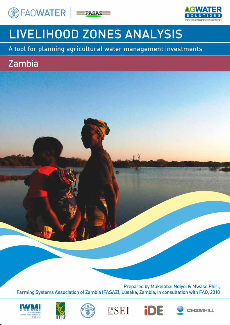
Improved livelihoods for smallholder farmers A tool for planning agricultural water management investments LIVELIHOOD ZONES ANALYSIS Zambia Prepared by Mukelabai Ndiyoi & Mwase Phiri, Farming Systems Association of Zambia (FASAZ), Lusaka, Zambia, in consultation with FAO, 2010
-
Upload
christina-dian-parmionova -
Category
Documents
-
view
277 -
download
6
description
Improved livelihoods for small holder famers - A tool for planning agricultural water management investments
Transcript of ZAMBIA : LIVELIHOOD ZONES ANALYSIS
Improved livelihoods for smallholder farmers
A tool for planning agricultural water management investments
LIVELIHOOD ZONES ANALYSIS
Zambia
Prepared by Mukelabai Ndiyoi & Mwase Phiri, Farming Systems Association of Zambia (FASAZ), Lusaka, Zambia, in consultation with FAO, 2010
About this report The AgWater Solutions Project aimed at designing agricultural water management (AWM) strategies for smallholder farmers in sub Saharan Africa and in India. The project was managed by the International Water Management Institute (IWMI) and operated jointly with the Food and Agriculture Organization of the United Nations (FAO), International Food Policy Research Institute (IFPRI), the Stockholm Environmental Institute (SEI) and International Development Enterprise (IDE). It was implemented in Burkina Faso, Ethiopia, Ghana, Tanzania, Zambia and in the States of Madhya Pradesh and West Bengal in India. Several studies have highlighted the potential of AWM for poverty alleviation. In practice, however, adoption rates of AWM solutions remain low, and where adoption has taken place locally, programmes aimed at disseminating these solutions often remain a challenge. The overall goal of the project was to stimulate and support successful pro-poor, gender-equitable AWM investments, policies and implementation strategies through concrete, evidence-based knowledge and decision-making tools. The project has examined AWM interventions at the farm, community, watershed, and national levels. It has analyzed opportunities and constraints of a number of small-scale AWM interventions in several pilot research sites across the different project countries, and assessed their potential in different agro-climatic, socio-economic and political contexts. This report was prepared as part of the efforts to assess the potential for AWM solutions at national level. The livelihood zones analysis divides the country in a series of areas where rural people share relatively homogeneous living conditions on the basis of a combination of biophysical and socio-economic determinants. It describes the main sources of livelihood of rural populations (by category of people), their natural resources base, potential and key constraints to development. It analyses the relation between people and water and helps understanding to what extent and how water can be a factor for development.
CONTENTS
CONTENTS ...................................................................................................................................... IABBREVIATIONSANDACRONYMS .............................................................................................................. III
1. BACKGROUND........................................................................................................................ 11.1 FROMFARMINGSYSTEMSTOLIVELIHOODZONES................................................................................ 11.2 TARGETINGNEEDS ........................................................................................................................ 1
Livelihoodsanalysed ...................................................................................................................... 2Externalenvironmentthatinfluencelivelihoods ........................................................................... 2
2. APPROACHUSEDTODELINEATETHELIVELIHOODZONES....................................................... 23. SYNOPTICPRESENTATIONOFAGRO‐ECOLOGICALREGIONSANDBROADLIVELIHOODSYSTEMS........................................................................................................................................ 5
3.1 REGIONI ..................................................................................................................................... 53.2 REGIONII .................................................................................................................................... 53.3 REGIONIII ................................................................................................................................... 5
Categoriesoffarmers .................................................................................................................... 9
4. DETAILEDDESCRIPTIONOFLIVELIHOODZONES.....................................................................104.1 LIVELIHOODZONE1(LZ1) ........................................................................................................... 104.2 LIVELIHOODZONE2(LZ2) .......................................................................................................... 114.3 LIVELIHOODZONE3(LZ3) .......................................................................................................... 124.4 LIVELIHOODZONE4(LZ4) .......................................................................................................... 134.5 LIVELIHOODZONE5(LZ5) .......................................................................................................... 134.6 LIVELIHOODZONE6(LZ6) .......................................................................................................... 144.7 LIVELIHOODZONE7(LZ7) .......................................................................................................... 154.8 LIVELIHOODZONE8(LZ8) .......................................................................................................... 154.9 LIVELIHOODZONE9(LZ9) .......................................................................................................... 164.10 LIVELIHOODZONE10(LZ10) ...................................................................................................... 164.11 LIVELIHOODZONE11(LZ11) ...................................................................................................... 174.12 LIVELIHOODZONE12(LZ12) ...................................................................................................... 184.13 LIVELIHOODZONE13(LZ13) ...................................................................................................... 194.14 LIVELIHOODZONE14(LZ14) ...................................................................................................... 194.15 LIVELIHOODZONE15(LZ15) ...................................................................................................... 204.16 LIVELIHOODZONE16(LZ16) ...................................................................................................... 214.17 LIVELIHOODZONE17(LZ17) ...................................................................................................... 214.18 LIVELIHOODZONE18(LZ18) ...................................................................................................... 22
5. APPLICATIONOFTHELIVELIHOODZONES..............................................................................235.1 INVESTMENTPOTENTIALTHROUGHAWMINTERVENTIONSINLIVELIHOODZONES.................................. 235.2 SUITABILITYDOMAINSFORSELECTEDAWMINTERVENTIONSATNATIONALLEVEL .................................. 26
ANNEXES ......................................................................................................................................28ANNEX1–THEEVOLUTIONOFLIVELIHOODZONESINZAMBIA.................................................................... 28
ANNEX2–AGRO‐ECOLOGICALREGIONS .......................................................................................31ANNEX3–DELINEATIONANDDESCRIPTIONPARAMETERSANDVARIABLESFORLIVELIHOODANALYSISINZAMBIA ....................................................................................................................35
ii
ListofFigures1 DATASETSUSEDINLIVELIHOODDELINEATIONANDDESCRIPTION 42. LIVELIHOODZONESOFZAMBIA 103. PRIORITYFORAWMINTERVENTIONS 254. GROUNDWATERTABLEINJULY 265 LIVELIHOODZONESINZAMBIABYTHEFHANISREVIEWTEAM 286 LIVELIHOODZONESINZAMBIABYTHEZVAC 297 EARLIERCONTRIBUTIONOFFAOTOTHELIVELIHOODZONEMAP 308` AGRO‐ECOLOGICALREGIONSANDAGRICULTURALENTERPRISES 33ListofTables1 SYNOPTICPRESENTATIONOFLIVELIHOODZONES 62 LIVELIHOODZONESANDCRITERIATOTARGETAWMINTERVENTIONS 243 SUITABILITYDOMAINSFORSELECTEDAWMINTERVENTIONS ATNATIONALLEVEL 26
iii
AbbreviationsandacronymsAEZ Agro‐ecologicalzoneARPT AdaptiveResearchPlanningTeamAWM AgriculturalwatermanagementCSO CentralStatisticsOfficeFAO FoodandAgriculturalOrganizationoftheUnitedNationsFASAZ FarmingSystemsAssociationofZambiaFEWSNET FoodEarlyWarningSystemNetworkFHANIS FoodSecurity,NutritionandHealthMonitoringSystemIFAD InternationalFundforAgriculturalDevelopmentNTFP Non‐timberforestproductsNWP NorthWesternProvinceUNICEF UnitedNationsInternationalChildren’sEmergencyFundWFP WorldFoodProgrammeZVAC ZambiaVulnerabilityAssessmentCommittee
1
1. BACKGROUND
1.1 FromfarmingsystemstolivelihoodzonesFarmingSystemsResearchisbasedonathoroughunderstandingofthefarmingsystempracticedsothat interventionscanbetailoredtouniquecircumstancesandrecommendationsmade. Overtheyears,weaknesseshavebeennotedintheuseofthefarmingsystemsapproach.Itbecameclearthatfarming systems focused on cropping enterprises and hardly addressed activities such asmigrantlabouror theworkofmetalworkersbeyondamention in thediagnostic report. Itwas clear thatwhatactuallycontributedtolivelihoodswasnotaddressed.Theshiftwasthusmadefromafarmingsystemsapproachtoalivelihoodsapproach.The farming systemsmap of Zambiawas created after nearly 10 years of diagnostic and on‐farmresearch work. Since then, the Central Statistics Office (CSO) and the Zambia VulnerabilityAssessmentCommittee(ZVAC)haveproduceda livelihoodsmapbasedonexpertassessmentsandlimited field verification. The Farming Systems Association of Zambia (FASAZ) and the Food andAgriculture Organization of the United Nations (FAO) have contributed to the refinement of thelivelihoodzones,inthiscase,byhighlightingtheirrigationlayer.
1.2 TargetingneedsWorkonimprovinglivelihoodsisguidedbythedefinitionoflivelihoodsbyChambersandConway:Alivelihood comprises the capabilities, assets (stores, resources, claims and access) and activitiesrequiredforameansofliving.Itcomprisestheadequatestocksandflowsoffoodandcashrequiredtomeetbasicneeds.Itismadeupofarangeoffarmandoff‐farmactivities,whichtogetherprovideavarietyofprocurementsourcesforfoodandcash.Thuseachhouseholdcanhaveseveralpossiblesourcesofentitlement,whichcompriseitslivelihood.Theseentitlementsarebasedonendowmentsof a household, and its position in the legal, political and social fabric of society. A livelihood issustainablewhenit(i)cancopewithandrecoverfromstressandshocks;(ii)maintainorenhanceitscapabilities and assets; and can (iii) provide sustainable livelihood opportunities for the nextgeneration.Livelihood erosion occurs when the options open to households on how to transform theirendowments or assets into food and cash entitlements diminish. Examples of this might includenaturalresourcedegradation(declineinforests,groundwater,fishstocks);climaticshocks;changestrade levels and increase in illness. The risk of entitlement failure determines the level ofvulnerabilityofahouseholdtofoodinsecurity.Thegreatertheshareofresourcesdevotedtofoodacquisitionthegreaterthevulnerability.The following three attributes are embodied in the idea of a livelihood: possession of humancapabilities(education,skills,health,selfesteem,psychologicalorientation);accesstotangibleandintangible assets (stores, resources, claims and access), and the existence of economic,social/cultural,andconsumptionactivities(e.g.gardening,fishing,farming).It is understood that a farm household’s activities are influenced by the assets possessed by thehouseholdmembers,butoftenitislessreadilyrecognizedthatbothactivitiesandassetlevelsmaybeheavily influencedby the capabilitiesof thesemembers. The conceptof capability is thereforeoneofthecriticalelementsofthelivelihoodapproach.Anotherimportantissueistheabilityofthehouseholdtorecoverfromstressandshocks,andhencetherelativedurabilityoftheselivelihoods.Assuchtheconceptsofresilience,socialcapitalandsensitivityareimportantforlivelihoodanalysis.The main point here is that people develop a range of livelihood activities, based upon theiravailableassetsandcapabilities.
2
Livelihoodsanalysed
Livelihoods analysis is an approach that helps determine how people live or make a living. Itincorporatesanunderstandingofhowhouseholdcapabilities;assetsandactivitiescombinewithinaspecified environment to achieve household well being in the short and long term. Livelihoodsanalysisassessestheresilienceofhouseholdstrategiesinthefaceofshocksandstresses,andassistsin identifying vulnerable areas or groups. The findings generated provide a useful framework forsupportinghouseholdsinresistingandrecoveringfrombothexternalthreats,forexample,drought,or internal threats, forexample family illness).Equally, livelihoodsanalysisassesses thehouseholdstrategies in the face of assets or endowments and capabilities, and assists in identifying highpotentialareasorgroups.Alivelihoodsanalysisaimstoincreaseunderstandingabout:• Thenatureoflivelihoodsfordifferentcategoriesofpeople.• Themainissuesconcerninglivelihoods,suchas:
o majortrends,problemsandconstraints;o shocksandstresses;o copingandadaptivestrategies;o overallandabsolutelevelsoflivelihoodinsecurityandvulnerability.
• Theopportunitiesandpotentialsforaddressingtheseissues.• Potentialstrategiesandprioritiesaswellasactionstobetaken.
Manyorganizations andpractitioners apply livelihood analytic approaches to gain insight into thelives and livelihoods of at risk communities. This information is used for planning, monitoring orevaluation.Moreover,anunderstandingofchanginghouseholdandcommunitylivelihoodstrategiesiscriticalwhendesigningsustainabledevelopmentpoliciesaswellasprogrammesthatreduceriskand build on local capacities. Poverty‐focused development activity should be dynamic: externalsupportmust recognize thedynamicnatureof livelihoodstrategies, respondflexibly tochanges inpeople’ssituation,anddeveloplong‐termcommitments.
Externalenvironmentthatinfluencelivelihoods
Theexternalenvironmentwillinfluencehouseholdcapabilities,assetsandactivities.Examplesoftheexternalenvironmentare thepoliticalclimate includinggovernmentpolicies,empowerment,basicservices, community norms and values/claims, changes in the economy, markets, naturalenvironment,donorprogrammesandpolitics.
2. APPROACHUSEDTODELINEATETHELIVELIHOODZONESThiswork isnot theonlyattemptatdividingZambia into livelihoodzones.The firstwasbyaCSOteam charged to revise the Food Security, Nutrition and Health Monitoring System (FHANIS)methodology.A livelihoodapproachwasdeemedappropriatehere inunderstanding the foodandnutritionsituationinacommunityandhowitwillchangeintheeventofastress.TheFHANIS,wasfundedbytheUnitedNationsChildren’sFund(UNICEF)anda loanfromtheInternationalFundforAgriculturalDevelopment(IFAD) late1990.Thesecondattemptwasthe livelihoodmapdevelopedunder the auspices of the World Food Programme (WFP) and the Food Early Warning SystemNetwork(FEWSNet)andotherpartners.Againtheobjectivewastogaugethefooddeficittoprovideanearlywarningtothegovernmentanddonorstofacilitateappropriateresponseintimesofstress.Thispresentworkaimstocontributetotheunderstandingoflivelihoodzonesbyincludingalayerontheaccessibilityofwater(surfaceandground)andtolow‐costwater‐liftingdevicesappropriateforsmallholderirrigation.
3
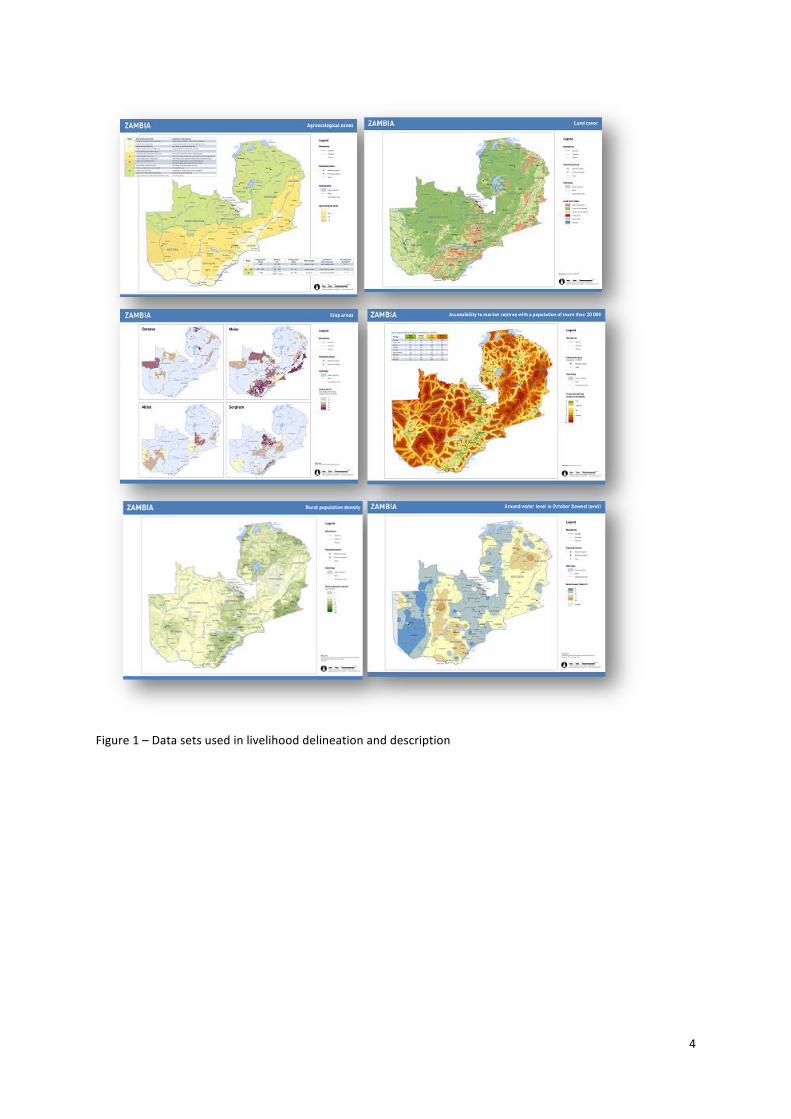
Criteria for delineating zone boundaries were identified, including those that enriched thedescription of each livelihood zone (see Annex 3). Next, available national biophysical and socio‐economic spatial data sets needed to describe the livelihood zones were collected and compiledfrom government agencies, academia and the United Nations. These were layered and used todescribethelivelihoodzones.A single map was obtained where 18 livelihood zones were considered relatively homogeneousbasedonkeyvariablessuchasagro‐ecologicalregions,agriculturalpractices,cropsgrown,accesstomarketsandavailabilityofwater.Thepresenceofgamereserveareas, landcoverandtopographywerealsotakenintoconsideration.During the participatorymapping exercise, groupswere given general guidance but the choice ofdelineation factorswere left open. Each group adopted a rather differentmapping approach andcameupwithdifferentmapsbasedondifferentprioritycriteria that increasedtherichnessof theexerciseandgaveaslightvariationinemphasis.Discussionsofcharacteristics,pointsofsimilaritiesand differences, enabled participants to successfully arrive at an agreement on a common list oflivelihoodzonesandtheirmappedboundaries.
4
Figure1–Datasetsusedinlivelihooddelineationanddescription
5
3. SYNOPTIC PRESENTATION OF AGRO‐ECOLOGICAL REGIONS AND BROAD LIVELIHOODSYSTEMS
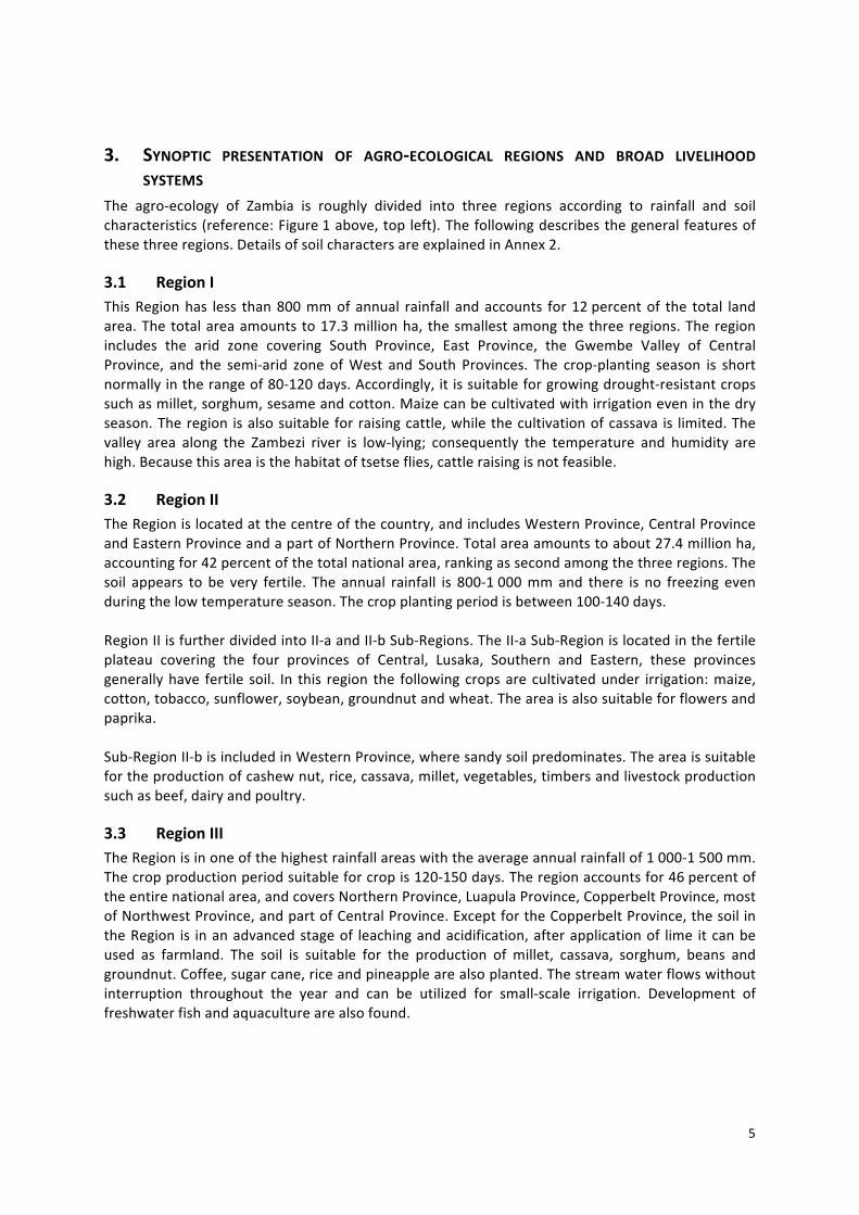
The agro‐ecology of Zambia is roughly divided into three regions according to rainfall and soilcharacteristics(reference:Figure1above,topleft).Thefollowingdescribesthegeneralfeaturesofthesethreeregions.DetailsofsoilcharactersareexplainedinAnnex2.
3.1 RegionIThisRegionhas less than800mmofannual rainfall andaccounts for12percentof the total landarea.Thetotalareaamountsto17.3millionha, thesmallestamongthethreeregions.Theregionincludes the arid zone covering South Province, East Province, the Gwembe Valley of CentralProvince, and the semi‐arid zone ofWest and South Provinces. The crop‐planting season is shortnormallyintherangeof80‐120days.Accordingly,itissuitableforgrowingdrought‐resistantcropssuchasmillet,sorghum,sesameandcotton.Maizecanbecultivatedwithirrigationeveninthedryseason.Theregion isalsosuitableforraisingcattle,whilethecultivationofcassava is limited.Thevalley area along the Zambezi river is low‐lying; consequently the temperature and humidity arehigh.Becausethisareaisthehabitatoftsetseflies,cattleraisingisnotfeasible.
3.2 RegionIITheRegionislocatedatthecentreofthecountry,andincludesWesternProvince,CentralProvinceandEasternProvinceandapartofNorthernProvince.Totalareaamountstoabout27.4millionha,accountingfor42percentofthetotalnationalarea,rankingassecondamongthethreeregions.Thesoil appears to be very fertile. The annual rainfall is 800‐1000mmand there is no freezing evenduringthelowtemperatureseason.Thecropplantingperiodisbetween100‐140days.RegionIIisfurtherdividedintoII‐aandII‐bSub‐Regions.TheII‐aSub‐Regionislocatedinthefertileplateau covering the four provinces of Central, Lusaka, Southern and Eastern, these provincesgenerallyhave fertile soil. In this region the followingcropsarecultivatedunder irrigation:maize,cotton,tobacco,sunflower,soybean,groundnutandwheat.Theareaisalsosuitableforflowersandpaprika.Sub‐RegionII‐bisincludedinWesternProvince,wheresandysoilpredominates.Theareaissuitablefortheproductionofcashewnut,rice,cassava,millet,vegetables,timbersandlivestockproductionsuchasbeef,dairyandpoultry.
3.3 RegionIIITheRegionisinoneofthehighestrainfallareaswiththeaverageannualrainfallof1000‐1500mm.Thecropproductionperiodsuitableforcropis120‐150days.Theregionaccountsfor46percentoftheentirenationalarea,andcoversNorthernProvince,LuapulaProvince,CopperbeltProvince,mostofNorthwestProvince,andpartofCentralProvince.ExceptfortheCopperbeltProvince,thesoilintheRegion is inanadvancedstageof leachingandacidification,afterapplicationof lime itcanbeused as farmland. The soil is suitable for the production of millet, cassava, sorghum, beans andgroundnut.Coffee,sugarcane,riceandpineapplearealsoplanted.Thestreamwaterflowswithoutinterruption throughout the year and can be utilized for small‐scale irrigation. Development offreshwaterfishandaquaculturearealsofound.
6
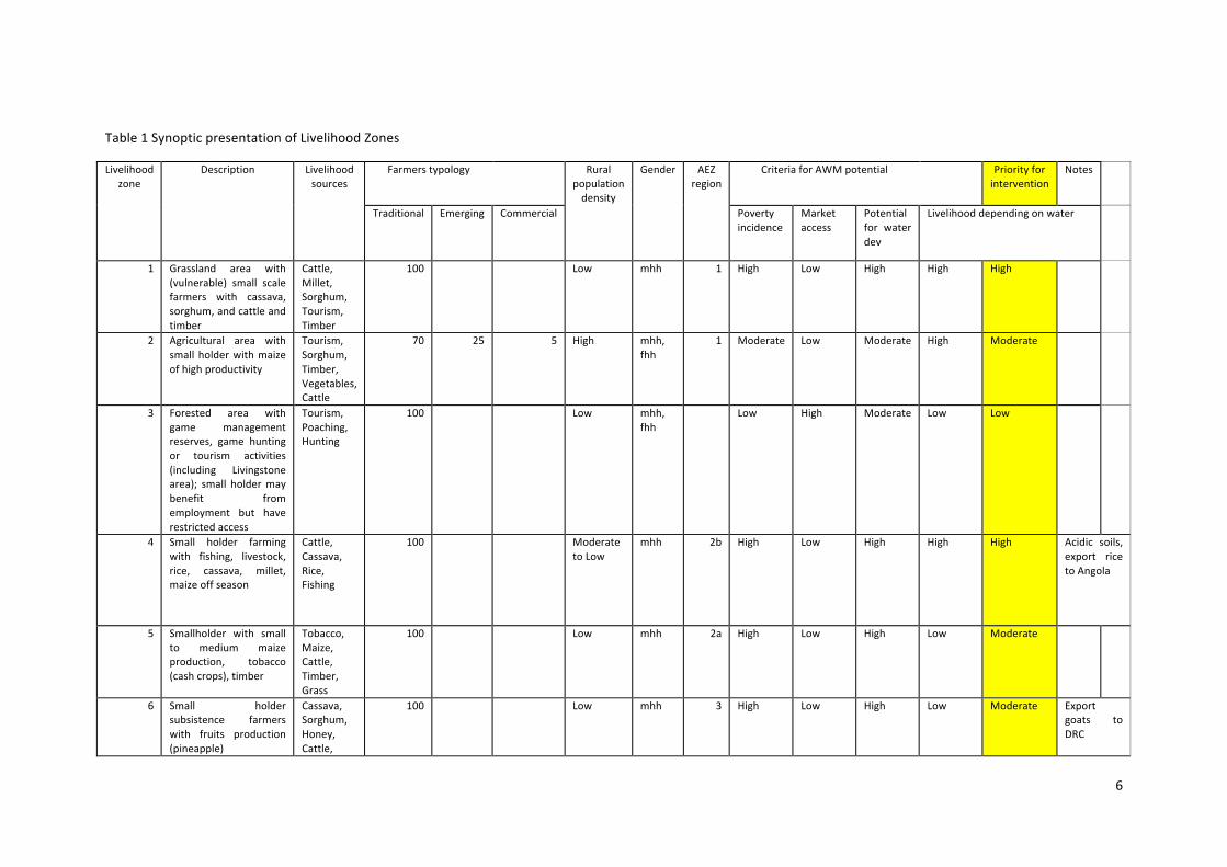
Table1SynopticpresentationofLivelihoodZones
Livelihoodzone
Description Livelihoodsources
Farmerstypology Ruralpopulationdensity
Gender AEZregion
CriteriaforAWMpotential Priorityforintervention
Notes
Traditional Emerging Commercial Povertyincidence
Marketaccess
Potentialfor waterdev
Livelihooddependingonwater
1 Grassland area with(vulnerable) small scalefarmers with cassava,sorghum,andcattleandtimber
Cattle,Millet,Sorghum,Tourism,Timber
100 Low mhh 1 High Low High High High
2 Agricultural area withsmallholderwithmaizeofhighproductivity
Tourism,Sorghum,Timber,Vegetables,Cattle
70 25 5 High mhh,fhh
1 Moderate Low Moderate High Moderate
3 Forested area withgame managementreserves, game huntingor tourism activities(including Livingstonearea); small holdermaybenefit fromemployment but haverestrictedaccess
Tourism,Poaching,Hunting
100 Low mhh,fhh
Low High Moderate Low Low
4 Small holder farmingwith fishing, livestock,rice, cassava, millet,maizeoffseason
Cattle,Cassava,Rice,Fishing
100 ModeratetoLow
mhh 2b High Low High High High Acidic soils,export ricetoAngola
5 Smallholder with smallto medium maizeproduction, tobacco(cashcrops),timber
Tobacco,Maize,Cattle,Timber,Grass
100 Low mhh 2a High Low High Low Moderate
6 Small holdersubsistence farmerswith fruits production(pineapple)
Cassava,Sorghum,Honey,Cattle,
100 Low mhh 3 High Low High Low Moderate Exportgoats toDRC
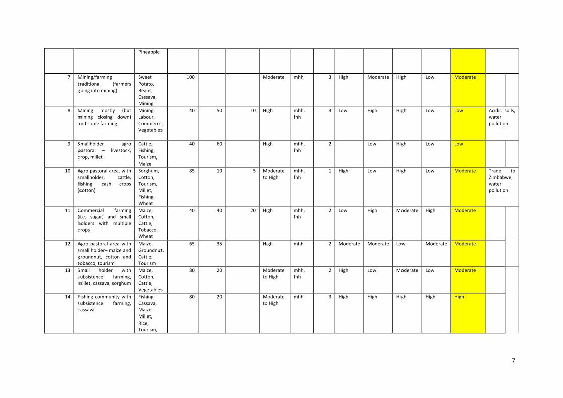
7
Pineapple
7 Mining/farmingtraditional (farmersgoingintomining)
SweetPotato,Beans,Cassava,Mining
100 Moderate mhh 3 High Moderate High Low Moderate
8 Mining mostly (butmining closing down)andsomefarming
Mining,Labour,Commerce,Vegetables
40 50 10 High mhh,fhh
3 Low High High Low Low Acidic soils,waterpollution
9 Smallholder agropastoral – livestock,crop,millet
Cattle,Fishing,Tourism,Maize
40 60 High mhh,fhh
2 Low High Low Low
10 Agropastoralarea,withsmallholder, cattle,fishing, cash crops(cotton)
Sorghum,Cotton,Tourism,Millet,Fishing,Wheat
85 10 5 ModeratetoHigh
mhh,fhh
1 High Low High Low Moderate Trade toZimbabwe,waterpollution
11 Commercial farming(i.e. sugar) and smallholders with multiplecrops
Maize,Cotton,Cattle,Tobacco,Wheat
40 40 20 High mhh,fhh
2 Low High Moderate High Moderate
12 Agro pastoral areawithsmallholder–maizeandgroundnut, cotton andtobacco,tourism
Maize,Groundnut,Cattle,Tourism
65 35 High mhh 2 Moderate Moderate Low Moderate Moderate
13 Small holder withsubsistence farming,millet,cassava,sorghum
Maize,Cotton,Cattle,Vegetables
80 20 ModeratetoHigh
mhh,fhh
2 High Low Moderate Low Moderate
14 Fishing communitywithsubsistence farming,cassava
Fishing,Cassava,Maize,Millet,Rice,Tourism,
80 20 ModeratetoHigh
mhh 3 High High High High High
8
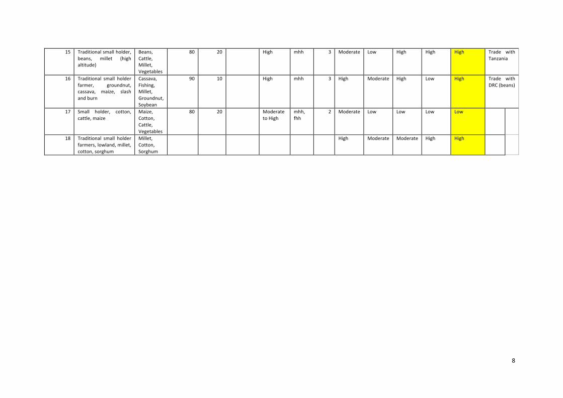
15 Traditionalsmallholder,beans, millet (highaltitude)
Beans,Cattle,Millet,Vegetables
80 20 High mhh 3 Moderate Low High High High Trade withTanzania
16 Traditional small holderfarmer, groundnut,cassava, maize, slashandburn
Cassava,Fishing,Millet,Groundnut,Soybean
90 10 High mhh 3 High Moderate High Low High Trade withDRC(beans)
17 Small holder, cotton,cattle,maize
Maize,Cotton,Cattle,Vegetables
80 20 ModeratetoHigh
mhh,fhh
2 Moderate Low Low Low Low
18 Traditional small holderfarmers,lowland,millet,cotton,sorghum
Millet,Cotton,Sorghum
High Moderate Moderate High High
9
Categoriesoffarmers
There are threemajor categories of farmers: smallholder (traditional) farmers cultivate less than5ha, use mainly hand hoes and few external inputs, and consume most of their produce.Smallholders account for 96percent1 of Zambia's estimated 1100000 farm households, farmingmore than 76percent of the total cropped area. These smallholders use low‐cost irrigation andwatermanagementmethods.Mostfemalefarmersfallwithinthisgroup.Medium‐scale farmers cultivatebetween5and20ha.They supplementhandhoeswithoxenandtendtodependonexternalinputsandmechanization.Theysellmostoftheirharvestbutkeepsomefor home consumption. These farmers apply low‐ to medium‐cost irrigation methods withmechanization.Onlyasmallproportionoffemalefarmersfallintothisgroup.Large‐scaleor‘commercial’farmerscultivateover20ha,mainlyrelyingonmechanization,improvedseeds,fertilizers,chemicals,animaldraftpowerortractors,andsellmostoftheirproduction.Large‐scale farmers producemost of thewheat, soybean, coffee,milk, high‐value and horticultural andexportcropsandaccountformost livestockproductsales. Veryfewfemalefarmerscanbefoundamongcommercialfarmers.AccordingtothecalculationbyThurlowetal.2008,basedonthelivingconditionsmonitoringsurveyof2004,themedium‐andlarge‐scalefarmerscomprise4percentoffarmhouseholds.
1CalculatedfromtheLCMS,2004inJamesThurlowetal.(2008)AgriculturalgrowthandinvestmentoptionsforpovertyreductioninZambia.
10
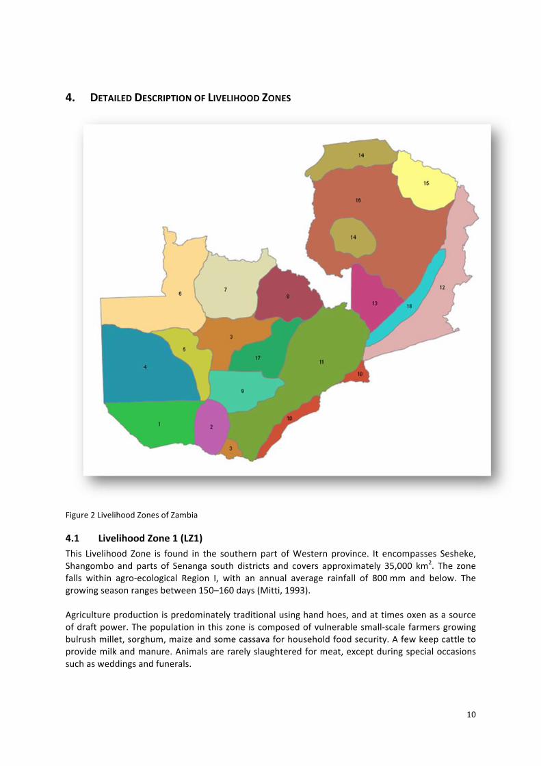
4. DETAILEDDESCRIPTIONOFLIVELIHOODZONES
Figure2LivelihoodZonesofZambia
4.1 LivelihoodZone1(LZ1)This Livelihood Zone is found in the southern part ofWestern province. It encompasses Sesheke,Shangombo and parts of Senanga south districts and covers approximately 35,000 km2. The zonefalls within agro‐ecological Region I, with an annual average rainfall of 800mm and below. Thegrowingseasonrangesbetween150–160days(Mitti,1993).Agricultureproductionispredominatelytraditionalusinghandhoes,andattimesoxenasasourceofdraftpower.Thepopulation inthiszone iscomposedofvulnerablesmall‐scalefarmersgrowingbulrushmillet,sorghum,maizeandsomecassavaforhouseholdfoodsecurity.Afewkeepcattletoprovidemilkandmanure.Animalsarerarelyslaughteredformeat,exceptduringspecialoccasionssuchasweddingsandfunerals.
11
The Zone is endowed with natural forests with important tree species and a wide‐range of wildanimals. This presents great potential for developing local crafts, lumber and tourism, whichcurrentlyislargelyunexploited.The rural populationof LZ1 is approximately 200,000people . Thehigh femalepopulation in thezoneinfluencesthetypeoflivelihoodactivitiesprominentinthezone.Almostallfarmersfoundinthislivelihoodzonearevulnerablesmall‐scalefarmerswhogrowvariouscropsforsubsistenceusingmainlyhandcultivationmethods,althoughoxenareoccasionallyused.Location–thisLZ1isfoundinfourdistrictsasmentionedabove.Itincorporatesfourdistinctfarmingsystems, i.e.FS50,51,52and53, (Mitti,1993);orTraditionalRecommendationDomains6,7,8,9(Muwamba,1988).Ethnicgroup–themainethnicgroupsareMbunda,Shanjo,Mashi,Mulonga,MbukushuFew,Lozi,Totela,Subiya,Toka,Nkoya,andChokwe.Withrespecttorainfall,theyearisdividedintotwodistinctseasons:thedryseason(April–October)and thewet season (November–March). The year is divided into threeperiods: a cool dry season(April–July);ahotdryseason(August–October);andawarm,wetseason(November–March).Duringthecooldryseasonfrostmayoccasionallyoccur,especiallyatnight.Livelihood Zone1 lieswithin agro‐ecological Region I,which receives less than 800mmof annualrainfall.Thegrowingseasonrangesbetween150‐160days.ThelowlandsinthevalleyareaalongtheZambeziriverexperiencehightemperaturesandhumidity.Thezonecanbeclassifiedassuitableforgrowingdrought‐resistantcropssuchasmillet,sorghum,sesameandcotton.Cultivationofcassavaiscurrentlylimited.Withirrigation,maizecanbecultivatedduringthedryseason.Thezoneisalsosuitableforraisinglivestockespeciallycattle.Thelivelihoodsystemcangenerallybedescribedasagrasslandareawherethemaincropsproducedformthelivelihoodsofmanypeople.Thesearebulrushmillet,sorghum,maizeandcassava,whichareproducedbysmall‐scalefarmersusingtraditionalhand‐cultivationmethods.Livestock(cattle)inthe zone are kept using two management systems: sedentary and transhumance. Cattle aresometimes used as draft power for cultivation, and provide meat and milk. In addition, manyfarmers are engaged in fishing from the rivers (particularly Zambezi and its tributaries) tosupplement their protein needs and income. Beer brewing, especially from millet and sorghum,togetherwithhandcrafts,timberandoccasionalcattlesalesareregularlivelihoodactivities.
4.2 LivelihoodZone2(LZ2)Livelihood Zone2 is confined to Kazungula district of Southern Province and fallswithin Zambia’sagro‐ecologicalZoneI.Themajorcharacteristicsofthis livelihoodzoneinclude,butarenotlimitedto,about90percentoffarmhouseholds.Maizeisgrownasafoodstaple,whileonly2percentgrowcassava (Haggblade, 2008). However, according tomajor farming systems of Zambia (Mitti, 1993)thiszonestraddlespartsoffarmingsystems41and52andthereissomeresemblanceto40and39.Infarmingsystems41and52thepredominantlivelihoodsarebasedonhybridmaize,sorghumandbulrushmilletcultivationalsobeef,milkandfishareraised.Ontheotherhandfarmingsystems39and 40 are typically the valley areas of Gwembe and Sinazongwe districts where the livelihoodsystems are notmuch different except for an added reliance of the surrounding communities ongamemeat.Toa small degree, inorder todiversifyhousehold income, rural communities in this zoneharvesthigh‐valuenon‐timberforestproducts(NTFPs).Theseinclude:i)harvestingseasonalmushrooms;ii)
12
collectingMopaneworms; iii)harvestingMungongonuts for itsoil; iv)carryingouttraditionalbeekeeping;v)collectingbaobabfruitandMubuyufruittosellinLusakaandotherurbanmarkets;andvi)harvestingthatchandpalmfrondsforbasketandmatmaking.Thedominant ethnic groups found in the zoneare TongaandToka in thenorth, Lozi, Subiya andTotelainthesouthwesternpartofthedistrict.Thefarmhouseholdsaremaledominated(65%)withtheremainder35percentarefemaleheaded.Regardingthedistributionofthefarmingpopulation,LZ2consistsofabout70percenttraditionalsubsistencefarmersfollowedby25percentemergentand5percentcanbeconsideredtobecommercialfarmers.Becauseofitsproximitytothetown,Livingstone,whichisacentrefortourism,thislivelihoodzonehasrelativelygoodroadinfrastructure;thetarredLivingstone–Seshekeroadpassesthroughit.Othercommunicationfacilitiesincludetelecommunication(mobilephonenetworks),linkstoneighbouringBotswanathroughtheKazungulapontoon.Although,currently,LivelihoodSystem2maynotdirectlybenefitfromelectricity,the33kvpowerlinefromLivingstonetoSeshekeisnearby.Otherservicesin the area are the public services provided by government institutions such as theMinistries ofAgricultureandCooperatives,EducationandHealth.Generally,althoughthezoneliesinthelowrainfallarea,withpoorsoils,livestockrearingispossiblebecauseofabundantpasturesintheriverbasinswherefloodingoccasionallyoccursasriversbursttheirbanks.Inthenorthernpartofthezone,whichliesontheplateauwheretherearemorefertilesoils,somesemi‐commercialfarmingispracticedusingoxencultivation.
4.3 LivelihoodZone3(LZ3)Thiszonecoversforestedareaswithgamemanagementreserves,gamehuntingortourismactivitiesofLivingstone,Kasempa,southeastSolweziandpartsofLufwanyamaandMufumbwedistricts.AccordingtomajorfarmingsystemsofZambia(Mitti,1993)atotaloffivedistinctfarmingsystemsare involved; namely FS 39 and 40,which are typical drought‐prone valley areasmainly coveringLivingstonedistrict, and FS 6,which is largelymaize/sorghumbasedwith someamount of fishingnear swamps,FS32andpartsofFS33. In the latter twosystemsbothsorghumand fingermillet,withsomemaizeprovideimportantstarchyfoodcropsforthepeople.Thecropgrowingseasonvariesfromalowof90‐100dayswith70percentprobability,4‐5dry(<30mm)10dayperiods,slightfrostriskinwinterandmeanmonthlyminimumtemperaturebetween18and19oC in Livingstone to a highof 140–170dayswith 70percent probability, slight frost risk inwinter, restricted (700–850hours) sunshinewithin the rainy season andmeanmonthlyminimumtemperatures of between 16 and 17oC during December to February in Kasempa and Solwezidistricts.Thisallowsawidevarietyoflivelihoodstobepracticed.Apartfromtheabove‐mentionedstarch food crops grown, other crops of economic importance are vegetables and beans. AroundLivingstone,commercialproductionofchiliesandirrigatedmaizeandwheatisgainingrecognition.Otherlivelihoodcashsourcesinthissystemincludebeerfromsorghumandmillet,vegetables,fish,game meat, honey and livestock (chicken) sales. In addition, tourism and game hunting formimportantlivelihoodactivities.The main ethnic groups in the zone are Kaonde, Lamba and Tonga speaking people. Almost100percentoffarmhouseholdsaremaleheaded/dominated.Soilsofthiszonecanbedescribedaspoorbecauseoftheinherentsoil infertilitybroughtaboutbynutrient leaching resulting from the high rainfall in Solwezi, Kasempa and Mufumbwe districts.
13
Veldkamp(1987)describedthesesoilsasstronglyleached,verystronglyacid,redtoreddishclayeyand slightly silty soils (with clayey to fine loamy top soils), usually with low retention capacity,derivedfromacidrocksinMiombovegetation.ThesoilsaroundLivingstonehavepoorwater‐holdingcapacityand lowfertilitybecauseoftheirsandynature.AccordingtoVeldkamp,theseareshallowsoilswithfineloamytoclayeytopsoilsonbasaltinMopanevegetation.
4.4 LivelihoodZone4(LZ4)Livelihood Zone 4 is found in Kalabo, Lukulu andwest of Kaoma, Senanga andMongu districts inagro‐ecological region II b of Western Zambia. In general, the zone consists of 100 percentsmallholder traditional farmers practicing fishing, livestock keeping and the cultivation of rice,cassava,milletandoff‐seasonmaize.However,cattlerearing,cassava,rice,beerbrewing,craftsandfishingareimportantlivelihoodactivities.Agro‐climaticallyLZ4experiencesawide‐range(110–150)daysofgrowingseasonwith70percentprobability occurrence of 3–4 dry (< 30mm) 10 day periods, slight to serious frost occurrence inKaoma, Mongu and Senanga and mean monthly minimum temperature between 18 and 19°CduringDecembertoFebruary.Six farming systems are recognised. These are FS 45 in west Kaoma district characterized by acombination of river‐based and upland settlements comprise a cattle, cassava/sorghum and fish‐based system. FS 46 and 47 cover Kalabo west and the flood plains of both Kalabo and Lukuludistrictsrespectively,whichcomprisebasicallycattle/fish‐basedsystems.TheotherFS48isfoundinthe central Zambezi flood plain ofMongu and Senanga districts,while FS 49 covers the plains ofLukuluwestandnorthofLiuwaplainsinKalabowithsettlementsinLuangingaandLwangembungurivers.FS50coverswestofZambeziriver,whichstretcheswesttoSenangaandSeshekedistrictsaswellassouthwestofKalabodistrict.The dominant ethnic groups in the zone include Kwangwa, Nyengo,Mwenyi,Mbunda, Lwalange,Lozi,Luvale,Nkoya,Chokwe,Lunda,ShanjoMashi,Mulonga,MbukushuandFwe.Althoughthepopulationdensity inthiszonehasbeendescribedelsewhereasmediumto low,theproportion of female‐headed households is relatively high about 25‐40 percent of the total farmhouseholds.Livelihood Zone 4 encompasses river basins and flood plains characterized by inaccessibleremoteness, labourshortages,anddrought‐proneareaswithchronic food insecurity.Thesoilsaremainly podzols that are imperfectly to very poorly drained, very strongly tomedium acid, coarsesandytocoarse loamysoils(withcoarsesandytopsoils) in largevalleydambosandhydromorphicplains. In addition to the above, in Kaoma district there are moderately to strongly leached, tomediumacid,well‐drained,reddishtoyellowish,loamytoclayeysoils,(withcoarseloamytoclayeytop soils) andpoorly to verypoorlydrained soilsof variable textureandacidityoccurring in largedepressionsorvalleysarecommon.
4.5 LivelihoodZone5(LZ5)Livelihood Zone 5 incorporates Kaoma,North East Lukulu, and some parts of North East Seshekedistricts in agro‐ecological region II a. Almost 100percent of all smallholder farms are owned bytraditional farmerswhodependonmaize, cassava, sorghumbulrushmilletandsweetpotatoesasstaplecrops.The livelihoodzonecanbestbedescribedasamulti‐staplecropsystemwherehiredlabour and oxen play a vital role in crop production. Tobacco, timber and grass form part of thelivelihoodcashincomeactivities.
14
Mitti, inhisdescriptionof themajor farmingsystemsofZambia,delineates this livelihoodzoneasfourdistinctfarmingsystems:FS42,43,44and53.BothFS42and43arefoundinKaomadistrict.This domain has a relatively well‐developed communication network compared to FS 44 and 53foundinLukuluandSeshekedistricts.Thelatterischaracterizedbypoorinfrastructurewithsparsepopulationconcentratedalongafewpermanentsandtracks.Agro‐climatically LZ 5 is similar to LZ 4 described above with the exception of Sesheke, whichexperiencesashortergrowingperiodof90–100dayswitha70percentprobability,occurrenceof4‐5dry(<30mm)10dayperiodswithinthegrowingseason,withseriousfrostriskinwinterandmeanmonthlyminimumtemperaturebetween18‐19°CduringDecembertoFebruary.SoilsofLZ5aresimilartothosedescribedforLZ4above.ThemainethnicgroupsfoundinthezoneincludeLozi,Nkoya,Luvale,Mbunda,Luchazi,ChokweandTokatribeswithabout20–40percentofhouseholdsbeingfemaleheaded.
4.6 LivelihoodZone6(LZ6)Livelihood Zone 6 is located in Mwinilunga, Kabompo, Zambezi and Chavuma districts ofNorthwesternprovince.Itliesinagro‐ecologicalregionIIIreceivingannualprecipitationinexcessof1000mm.Becauseofthehighrainfall,which leadstosoilnutrients leaching,thesoils inthezonearegenerallyacidicandhenceinfertile.AccordingtoSoilsofZambia (secondedition),sixsoilunitsarerecognizedinLZ6.Theseareunit3orshallowsoilsderivedfromacidrocks,occurringonhillsorhillyranges;unit7orstronglyleached,verystronglyacid,redtoreddishbrownclayeytoloamsoilsinMiombovegetation;unit9ormoderatelyleached,stronglytomediumacid,reddishbrownclayeytoloamysoils(withsandytocoarseloamytopsoils);unit19ornontoweaklypodzolic,verystronglyacid, coarse sandy soils (podzols) (with coarse sandy top soils) in a pan dambo area on Kalaharisands;unit22orimperfectlytoverypoorlydrained,verystronglytomediumacid,coarsesandytocoarseloamysoils(withcoarsesandytopsoils)inlargevalleydambosandhydromorphicplainsandunit23,whichisanassociationofnontoweaklypodzolic,verystronglytoslightlyacid,coarsesandyto coarse loamy soils and poorly to very poorly drained, very strongly tomedium acid, sandy tocoarseloamysoilsinlargedambosorplains.Unit19iswidespreadinLZ6.Thegrowingseasonhasa70percentprobabilityofrainfallwithinarangeof140–180dayswithlow(<700hours)ofsunshineduringtherainyseason.Theprobabilityofoccurrenceofdry(<30mm)10‐day periods increases from 1–3 from the northern part of the zone towards the southwest intoKabompoandZambezi/Chavuma.According tomajor farming systemsofZambia, this zone isdescribedas cassava‐based traditionalsubsistencefarmingsystem.Inotherwords,thechiefstaplecropiscassava,whichisadaptedtothepoorsoilsandlonggrowingseasoninthezone.However,othercropsgrownincludemaize,beans,groundnuts,rice,sweetpotatoesandpineapples.SomecattlearekeptinMwinilungaandZambezidistricts.Off‐farmlivelihoodactivitiesfoundinthezonearehoney,fishingandgamehunting.ThedominantethnicgroupsareLunda,Luchazi,Luvale,ChokweNkoya,andMbunda.Althoughfarmhouseholdsamongtheseethnicgroupsaremainlymaledominated,afew(31%)arefemaleheaded.The zone lies in remote and undeveloped parts of the country with poor communicationinfrastructure. With regard to accessibility to agricultural land, LZ 6 has moderate to pooraccessibility.Nationalforest,nationalparkorgamemanagementareascovermuchofthezone.
15
4.7 LivelihoodZone7(LZ7)Livelihood Zone 7 covers Solwezi, Kasempa and Northern parts of Mufumbwe districts inNorthwesternprovince.LikeLZ6,itfallswithinagro‐ecologicalregionIII.Veldkamp(1987)identifiedfivedistinctsoilunits.Theseareunits7,9,11,19and24.Generally,thesearestronglyleachedandvery strongly acid clayey or coarse sandy soils. In some parts of the zone (Kasempa) shallow,moderatelywelltoimperfectlydrained,loamysoils(withsandytocoarseloamytopsoil)overlateriteoccur.Agro‐climatically LZ 7 has a growing season of 130–180 dayswith slight risk of frost especially indambo areas, restricted (700–850) hours of sunshine in the rainy season and mean monthlyminimumtemperaturebetween16and18°CduringDecembertoFebruary.Although the farming system, according to the Adaptive Research Planning Team‐NorthWesternProvince (ARPT‐NWP), is sorghum‐based in which sorghum forms the chief staple crop, otherimportantcropsgrownincludesweetpotatoes,beansandcassava.Miningisanon‐farmlivelihoodactivity, which is increasingly gaining prominence especially in Lumwana area of Solwezi district.Other income sources are beer brewing from sorghum andmillet, gamemeat, honey and sellinglivestock,i.e.goatsmainlytoneighbouringDemocraticRepublicofCongo.In all three districts Kaonde is the dominant ethnic group. However, Lamba forms a significantproportion of the population in the eastern parts of Solwezi district. About 15percent of farmhouseholdsinthezonearefemaleheaded.Generallycommunicationfacilities,especiallyroadinfrastructureconnectingdistricts’headquarters,arebetterthaninLZ6above.However,feederroadsinthehinterlandremainpoormakingaccesstoagriculturalproductionareasandmarketdifficult.
4.8 LivelihoodZone8(LZ8)TheentireCopperbeltprovinceconstitutesLivelihoodZone8andfallswithinagro‐ecologicalregionIII,whichreceivesanaverageannualrainfallofapproximately1300mm.Ithasalong(130160)daysgrowing seasonwith a slight risk of frost inwinter (June–August) and ameanmonthlyminimumtemperaturebetween17and18°CduringDecembertoFebruary.AccordingtotheSoilsMapofZambia,onesoilunit(7)ispredominantandafewplaceswheresoilunit10aoccurs.SoilUnit7representsstronglyleached,stronglytoverystronglyacid,clayeytoloamsoils,derivedfromacidrockswithtopsoilpH(CaCl2)of4.0–5.5andsubsoilaciditystatusofpH4.0–6.0intheMiombovegetation,while,soilunit10aismoderatelytostronglyleached,tomediumacid,red,clayeysoilsderivedfrombasicrocksandpH(CaCl2)of4.5–6.0.There are two farming systems peri‐urban andMpongwe. The peri‐urban ismainly found in andaround the urban towns of Ndola, Mufulira, Chingola, Kitwe, Kalulushi and Chililabombwe. Itscharacteristicfeaturesarethehighnumbersofretiredminersandworkers/settlerswhoselivelihoodistrading,saleofclothesandvegetablesproduction.TheMpongwefarmingsystemisfoundintherural districts of the province, including Luanshya, Masaiti, Mpongwe and Lufwanyama, where awide‐rangeofstarchstaples includingmaize,sorghum,cassavaandmilletaregrown.Limitedcashcropssuchassoyabeans,cottonandsunflowerand,toalimitedextent,coffeearealsoimportant.Although a few mines have recently closed, rendering many unemployed, mining together withcommercestillremainthemostimportantlivelihoodactivitiesinthiszone.
16
IntheurbandistrictsethnicgroupsaremixedsincemostaremigrantworkersfromallpartsofthecountrywhodriftedtoCopperbeltinsearchofemploymentinthecoppermines.Lamba/Limaethnicgroupsdominateruralareasofthelivelihoodzone.Inthezoneabout40percentaretraditionalsubsistencefarmers;followedby50percentemergentand10percentmaybeconsideredtobecommercialfarmers.Communicationfacilitiesarerelativelybetterinthiszoneandaccesstomarketsisrelativelyeasy.
4.9 LivelihoodZone9(LZ9)Twodistrictsof Itezhi‐tezhiandNamwalaofSouthernprovincefallwithinthis livelihoodzone.Thezone forms part of agro‐ecological region II b and the annual precipitation is between 800–1000mm.Thelengthofthegrowingperiodis110–120days.Duringthistime23dry(<30mm)10dayperiodshavea70percentchanceofoccurring.ThezonemayexperienceseriousfrostbetweenJune and August and the mean monthly minimum temperature is between 17 and 18°C fromDecembertoFebruary.The soils found in this zone aremainlymoderately leached, strongly tomedium acid, reddish tobrownishclayeytoloamysoilsderivedfrombasicrocksofteninadmixturewithacidrocks,podzolsin a pan dambo area on Kalahari sands and imperfectly to very poorly drained, slightly acid toalkaline,clayeyfloodplainsoilswithvariabletextureandacidity.This zone consists of smallholder agro‐pastoralists, whose chief livelihood revolves around cattlerearing,fishing,tourism,milletandsomemaizeproduction.AccordingtomajorfarmingsystemsofZambia Livelihood Zone 9 fits into the general description of Plateau Ox System of southernprovince.Amix of cash crops, food crops and livestock characterizes this system. It has relativelygoodaccesstoagricultural inputsandcapacitytoexpandproduction.Themajorcashcropsgrownare hybridmaize and sunflower. Themajor food crops aremaize (local and hybrid), groundnuts,sweetpotatoes,sorghum,localandexoticvegetables,cowpeas,Bambaranuts,beansandpumpkins.Livestock is important especially for milk and draught power. However, farmers also keep otherlivestockspecies,e.g.goats,chickens,guineafowlsandat timespigs.An important featureof thiszoneisitsgreatpotentialfortourismespeciallyinItezhi‐tezhidistrict,whichformspartoftheKafueNationalPark.TheIla/Tongaarethedominantethnicgroupsinthelivelihooddomain.Ruralpopulationdensityismoderatetohighandpredominatelymaleheadedatapproximately96percent.There are two traditional farmer categories, making up 40percent of total households and theremainder60percentareemergentfarmers.Accesstoagriculturalproductionareasispoorwithmostofthelandareainthezonefallingundernationalparksandgamemanagementareas.
4.10 LivelihoodZone10(LZ10)ThisLivelihoodZonecomprisesthreedistrictsinSouthernProvince:Gwembe,Siavonga,Sinazongwe.Luangwadistrict in Lusaka province is also part of this livelihood zone. Basically LZ 10 is found invalley areas or agro‐ecological region I, which are drought prone receiving less than 800 mmprecipitationperannum.Thiszoneislocatedinruraltoremotepartsofthecountrymakingaccesstoagriculturalproductionareasandmarketsdifficult.
17
Althoughmaize isplanted, sorghumdoesmuchbetter inLZ10.Thezone ischaracterizedbypoorinfrastructure, hilly and rocky shallow soils and is usually infested with tsetse fly, limiting cattlerearing.Therefore,LZ10canbestbedescribedasanagro‐pastoralarea,withsmallholders,cattle,fishing,cashcrops(cotton)formingthemajorsourcesofcashforcommunitylivelihoods.Agro‐climatically, LZ10hasagrowingperiodof80 to100dayswith3 tomore than5dry10‐dayperiods during the growing season and ameanmonthlyminimum temperature between 20 and21°CduringDecembertoFebruary.ThesoilsofLZ10arepredominatelyslightlyacidtoalkaline,(Rift)valleyloamyandclayeysoils(withcoarsetofine loamtopsoils)occurring ingentlyundulatingareas inMopane,MungaandBaikiaeavegetation. Inaddition, shallowandgravelly soils,derived fromacid rocks,occur in rolling tohillyareas,includingescarpmentzonesinMiombovegetation.TheTonga,GobaandChikundaaremajorethnicgroupsfoundinLivelihoodZone10.However,SoliandLenjeformasignificantproportionofpopulationinpartsofLuangwadistrict.Three farmer categories are identified in LZ10,85percent canbe classifiedas traditional farmerswith 10 percent emergent and the remaining 5 percent as commercial. Moderate to high ruralpopulationdensityisevidentwithamajorityofhouseholdsbeingmaleheadedandordominated.
4.11 LivelihoodZone11(LZ11)This is probably oneof the largest livelihood zones identified. It comprises nine districts: Kalomo,Choma, Monze, Mazabuka, Lusaka, Kafue, Chongwe, Chibombo and northeast Kapiri Mposhi.LivelihoodZone11islocatedinthecentralplateauandhasthebestsoilsandclimateforagriculturalpurposes.Itfallswithinagro‐ecologicalregionII,whichreceivesannualrainfallof800–1000mm.Agro‐climaticallyitsgrowingseasonislowestinthesouthernpartofthezone,i.e.Kalomowhereitfalls within 100–110 days with a 70 percent probability occurrence of 3–4 dry (< 30mm) 10‐dayperiods during this season and serious frost risk in June to August, andmeanmonthlyminimumtemperaturebetween16to17°CfromDecembertoFebruary.Thisgrowingseason increasestoahighof130–140dayswithslightfrostriskandameanmonthlyminimumtemperature17to18°CinKapiriMposhi.TwomajorsoilunitsarefoundinLZ11.Veldkamp(1987)describedtheseassoilunits9and12.SoilUnit9 ismoderately leached, strongly tomediumacid, reddish tobrownish, clayey to loamy soils(withsandytocoarseloamytopsoils),derivedfromacidrocksinMiombovegetationwhile,soilunit12 is described as slightly leached,medium to slightly acid, red to reddish, clayey soils (with fineloamy to clayey top soils), derived frombasic rocks, often in admixturewith acid rocks inMungavegetation.(Mitti,1993)identifiedsevendistincttraditionalrecommendationdomainsoffarmingsystems:FS3,4,5,7,25,26,and41.Thefirstfoursystemsarefoundinthenorthernpartofthe livelihoodzone.Thefollowingfeaturesdistinguishthesystems,i.e.FS3ishand‐hoecultivationwithsomelimitedox‐hire.Sorghum,milletandsomemaizeareimportantstaplecrops.Sellingofmilletbeer,temporaryjobs(piecework)andcharcoalsalesformimportantlivelihoodactivities.OntheotherhandFS4haspredominantuseofoxenforbothcultivationaswellasfarmtransportation.Awide‐rangeofcropsisgrown with maize, sorghum finger millet and sweet potatoes as starch foods. Beans, vegetablesgroundnuts and fish form important diet ingredients. However, maize also forms the main cashsourcetogetherwithbeersales.
18
Farming system 5 is dominated by semi‐commercial (emergent) farmers and cattle ownership iswidespread. Maize forms the major starch staple, supplemented by sweet potatoes and somesorghum.Beef,chickenandfish,togetherwithvegetablesformthecommondietofthepeople.FS7isahomogeneoussingledomainofemergentfarmerswhousecattleandoxentechnologiesandhiretractors.As intheotherthreesystemsdescribedinthiszone,maizeformsthemajorstarchstaplewithsorghumusedforbeerbrewing.Cashcropsinthesystemincludemaize,cottonandsunflower.TheremainderFS25,26,and41arefound inthecentralandsouthernpartsofthezone.FarmingSystems25 and26 is semi‐commercial characterizedbymaize as amajor starch staple, oxen andtractorpower,andproductionofcashcropssuchassugarcane,cotton,sunflowerandvegetablesformingimportantlivelihoodactivitiesinthezone.FS41isdescribedbyMitti(1993)asplateauox‐systems,characterizedbyamixofcashcrops,foodcrops, and livestock. The main cash crops include hybrid maize, sunflower, cotton, and tobacco,whilefoodcropsarelocalandhybridmaize,groundnuts,sweetpotatoes,sorghum,localandexoticvegetables,cowpeas,Bambaranuts,beansandpumpkins.Livestockis importantformilkanddraftpower.TheSwaka,Lala,andBembaformthemainethnicgroupsinthenorthernpartofLZ11while,LenjeandTongaarefoundinthesouthernpart.Thecentralpartofthezonehasamixedethnicgroup.Inallethnicgroups,householdsaremaleheaded/dominated.Three farmer categories are identified: traditional, emergent and commercial in the followingproportions40:40:20respectively.Communicationinfrastructureinthezoneiscomparativelybetterthanmostzonesdescribedsofarexcept in the extreme north (Serenje, Mkushi), where communication is poor and presentsdifficultiestothefarmingcommunitiesaccessingbothinputsandmarketsforagricultural.
4.12 LivelihoodZone12(LZ12)Livelihood Zone 12 covers most of Eastern Province (Chama, Lundazi, Chipata, Chadiza, Katete,Petauke, Nyimba) in agro‐ecological region II and Isoka district in Northern Province in agro‐ecological region III.Therefore, intermsofrainfallmostofLZ12receivesbetween800–1000mmwith Isoka having in excess of 1000mmper year. This entails a crop‐growing season of 100–150daysmovingfromsouthtonorthinthezonewitha70percentprobabilityoccurrenceof34dry(30mm)10‐dayperiodsinNyimbaandlow(lessthan700)sunshinehoursduringtherainyseasonandmeanmonthlyminimumtemperaturebetween1415°CduringDecembertoFebruaryinIsoka.AccordingtoSoilsofZambia(Veldkamp,1987),ninesoilunitsareidentifiedinLZ12.Theseincludeshallow/associationofshallowandgravellysoilsderivedfromacidrocks,occurringinrollingtohillyareas, including escarpment zone in parts Isoka, Chama, Lundazi and Nyimba districts throughmoderatelyleached,stronglytomediumacid,reddishtobrownish,clayeytoloamysoils(withsandyto coarse loamy top soils), derived from acid rocks in Miombo vegetation and slightly leached,mediumtoslightlyacid,redtoreddish,clayeysoils(withfineloamytoclayeytopsoils),derivedfrombasic rocks, often in admixture with acid rocks inMunga vegetation of Chipata, Chadiza, Katete,PetaukeandNyimbadistricts.ThisLivelihoodZone12isdividedintotheplateau,theescarpment(relativelyuninhabited)andthevalley.InthevalleyfingermilletiswidelygrowninLuangwaChamainthenorth,sorghumandmaizeare important in Luangwa Central and local maize in Luangwa South. All valley areas are labourdependentsincenoanimaldraughtisusedbecauseoftsetseflyandtrypanosomiasis.However,thisarea has very high tourism potential. On the plateau farmers are grouped into either ox or hoe
19
cultivatorswithlocalmaizeandgroundnutsbeingmajorcrops.Overall,65percentoffarmersinLZ12 fall into the traditional categorywith the remainder35percentbeingcategorizedasemergentfarmers.The main ethnic groups include Chewa, Ngoni, Nsenga, Tumbuka, Senga, Kunda, Bisa, Chikunda,MambweandNamwanga.Amajorityofhouseholdsintheseethnicgroupsaremaleheadedwithahighruralpopulation.Communication infrastructure in the zone is comparatively fair except in parts of the valley areaswhere this ispoorandpresentsdifficulties to the farming communities toaccessboth inputsandmarketsforagriculturalpurposes.
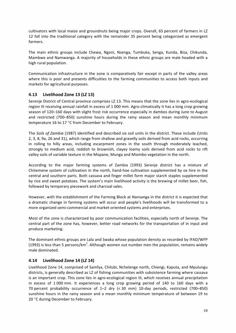
4.13 LivelihoodZone13(LZ13)SerenjeDistrictofCentralprovincecomprisesLZ13.Thismeansthatthezoneliesinagro‐ecologicalregionIIIreceivingannualrainfallinexcessof1000mm.Agro‐climaticallyithasalongcropgrowingseasonof120–160dayswithslightfrostriskoccurrenceespeciallyindambosduringJunetoAugustand restricted (700–850) sunshine hours during the rainy season and mean monthly minimumtemperature16to17°CfromDecembertoFebruary.TheSoilsofZambia(1987)identifiedanddescribedsixsoilunitsinthedistrict.Theseinclude(Units2,3,8,9a,26and31),whichrangefromshallowandgravellysoilsderivedfromacidrocks,occurringin rolling to hilly areas, including escarpment zones in the south through moderately leached,strongly to medium acid, reddish to brownish, clayey loamy soils derived from acid rocks to riftvalleysoilsofvariabletextureintheMopane,MungaandMiombovegetationinthenorth.According to the major farming systems of Zambia (1993) Serenje district has a mixture ofChitemenesystemofcultivationinthenorth,hand‐hoecultivationsupplementedbyoxhire inthecentralandsouthernparts.Bothcassavaandfingermilletformmajorstarchstaplessupplementedbyriceandsweetpotatoes.Thesystem’smainlivelihoodactivityisthebrewingofmilletbeer,fish,followedbytemporarypieceworkandcharcoalsales.However,withtheestablishmentoftheFarmingBlockatNansangainthedistrictitisexpectedthatadramatic change in farming systemswilloccurandpeople’s livelihoodswillbe transformed toamoreorganizedsemi‐commercialandmarket‐orientedsystemsandenterprises.Mostofthezoneischaracterizedbypoorcommunicationfacilities,especiallynorthofSerenje.Thecentralpartofthezonehas,however,betterroadnetworksforthetransportationof in inputandproducemarketing.ThedominantethnicgroupsareLalaandSwakawhosepopulationdensityasrecordedbyIFAD/WFP(1993)islessthan5persons/km2.Althoughwomenoutnumbermenthepopulation,remainswidelymaledominated.
4.14 LivelihoodZone14(LZ14)LivelihoodZone14,comprisedofSamfya,Chilubi,Nchelengenorth,Chiengi,Kaputa,andMpulungudistricts,isgenerallydescribedasLZoffishingcommunitieswithsubsistencefarmingwherecassavaisanimportantcrop.Thiszoneliesinagro‐ecologicalregionIII,whichreceivesannualprecipitationin excess of 1000mm. It experiences a long crop growing period of 140 to 160 days with a70percent probability occurrence of 1–2 dry (<30 mm) 10‐day periods, restricted (700–850)sunshinehours in the rainy seasonandameanmonthlyminimumtemperatureofbetween19 to20°CduringDecembertoFebruary.
20
ThesoilsinLZ14rangefromshalloworassociationsofshallowgravellysoilsderivedfromacidrocksoccurring in rolling to hilly areas and shallow to deep, strongly leached acid, reddish to brownishclayey to loamy soils; derived from acid rocks in Miombo vegetation, through to very stronglyleached,very stronglyacid, reddish, loamy todarkbrownish loamy toclayeysoilswith fine loamytop soils derived from acid rocks. Associations of very strongly leached, very strongly acid, well‐drained,brownishtoyellowish,loamytoclayeyinMiombovegetationandpoorlydrainedfloodplainsoils of variable texture and acidity in lake Basin Chipya vegetation surrounded by swamp orgrassland.According to Mitti (1993), the farming systems are: i) Lakes depression system, ii) Chambeshi‐Bangweulu(marshlands)systemsinSamfyadistrictandiii)grassmoundcultivationsysteminpartsofNchelengeandMpulungudistricts.Thefirsttwosystemsarebasedoncassavaandfish.Cassavaismainly grownonmounds in permanent fields,while fishing provides amajor livelihood source ofincome. In addition, rice is an important cash crop in themarshlands. The third system is a grassmound(Fundikila)systemwithmaizeandbeansasmajorcrops.Somefingermilletandcassavaarealsogrownasstarchstaples.Cattlearekeptforprotein,draftpowerandcash.TheethnicgroupsfoundinLZ14includeNg’umbo,MamboandMakuluinSamfya,Lunda,AushiinNchelengeandChiengedistricts.CommunicationfacilitieswithinLZ14varyfrompoorinandaroundtheswampyareasofSamfyatomoderatelyfairinLakeBangweuluareaandcomparativelygoodinMpulungudistrict.
4.15 LivelihoodZone15(LZ15)MbalaandNakondeinNorthernProvinceformLZ15.Agro‐climaticallythezoneexperiencesalonggrowing season 140–170 days with a 70percent probability, 1–2 dry (<30 mm) 10‐day periodswithin the growing season with less than 700 sunshine hours in the rainy season (especially inMbala) and a mean monthly minimum temperature between 14 to 15°C during December toFebruary.The soils range from shallow and gravelly soils derived from acid rocks through associations ofshallow soils occurring on hills, and moderately leached, strongly to medium acid, reddish tobrownishclayeytoloamysoilsderivedfrombasicrocksinMiombovegetation.Inaddition,stronglyleached, strongly acid, red clayey soils with low retention capacity derived from acid rocks tobrownishclayeyandloamsoilsallinMiombovegetationarecommon.According toMitti (1993), twodistinct farming systemsare identified.Theseare theChambeshi–Bangweulu(marshlands)andgrassmoundcultivationsystems.ThesesystemshavebeenadequatelydescribedinLZ14above.LZ15is80percenttraditionalsmallholdersandtheremainder20percentemergentfarmersinhighaltitudesgrowingmainlybeansandmillet.Cattleandvegetablesarealsoimportantlivelihoodactivitiesinthesystem.TheMambweandNamwangaarethemainethnicgroupsinthezone.Thepopulationdensityisrelativelyhigh,i.e.greaterthan100peopleperkm2inMbalaand25–100peopleperkm2inNakonde(IFAD/WFP,1993),withmale‐headedhouseholds.Thezone’sproximitytoborderareaswithneighbouringTanzaniaandLakeTanganyika isprobablyacontributingfactor.Communicationfacilitiesarerelativelyfairtoalloweasyaccesstoagriculturalinputsanddeliveryofinputsandproductstomarkets.
21
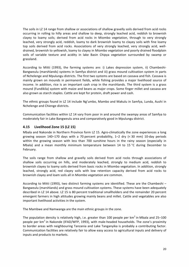
4.16 LivelihoodZone16(LZ16)Thisisoneofthelargestlivelihoodzonesidentified.Itcoversatotalof10districtsinNorthernandLuapula provinces. Agro‐climatically LZ 16 falls in the high rainfall region III. The growing seasonrangesfromalowof140daysinMpika,ChinsaliandMwensetoahighof200daysinKawambwa.Partofthezonehasa70percentprobabilityof1‐2dry(<30mm)10‐dayperiodsduringthegrowingseasoninMwense,restricted(700–850)sunshinehoursduringtherainyseasoninsevenoutofthetendistrictsandameanmonthlyminimumtemperatureofbetween19and20°CduringDecemberto February. The remaining districts of Kawambwa, Mporokoso, Luwingu, receive less than 700sunshinehoursduringtherainyseasonandexperiencelowermeanmonthlyminimumtemperaturesbetween16and17°CduringDecembertoFebruary.ThesoilsofLZ16aremainlystronglyleached,stronglytoverystronglyacid,redtobrownishclayeyto loam soils, derived from acid rocks in Miombo vegetation and association of shallow soilsoccurringonhills,andshallowtodeep,stronglyleached,toverystronglyacid,reddishtobrownish,clayeytoloamysoils,derivedfromacidrockstooinMiombovegetation.InpartsofLZ16(MilengeDistrict)thereisassociationof(very)stronglyleached,verystronglyacid,well‐drained,brownishtoyellowish, loamy to clayey in Miombo vegetation and poorly drained floodplain soils of variabletextureandacidityinLakeBasinChipyavegetationandswampgrasslandofKawambwadistrict.TherearetwodistinctfarmingsystemsinLZ16,whichhavebeendescribedbyMitti(1993).ThesearethePlateauChitemenesystemandLakesDepressionsystem.Thefirstsystemischaracterizedbyextensive shifting cultivation (Chitemene) based on finger millet, cassava, beans and somegroundnuts. The latter on the other hand is mainly based on cassava and fish. Therefore, fingermillet and cassava form the major starch staples along with beans and groundnuts. Importantlivelihoodactivitiesontheplateau includesellingmaize,groundnutsandbeanswhile, intheLakesDepressionsystemfishingistheprimarylivelihoodengagement.Ninety percent of farmers in this zone are classified as traditional smallholders practicing shiftingcultivationandtheremaining10percentareemergentandengaged in hybridmaizeandsoybeanproduction.TheethnicgroupsBemba,Chishinga,Lunda,Aushi,andNg’umboaredominantinthezone.
4.17 LivelihoodZone17(LZ17)Livelihood Zone 17 is found in Central and Copperbelt provinces and comprises Chibombo,Mumbwa,KapriMposhiWestandMpongwedistricts.Thefirstthreedistrictsareinagro‐ecologicalregionII,whileMpongweisinregionIII.Asaresultthezoneexperiencesamediumtolonggrowingseasonof110daysinChibomboandMumbwaand150daysinMpongwe.ThecommonsoiltypefoundinthiszonebelongstowhatVeldkamp(1987)describedasmoderatelyleached,stronglytomediumacid,reddishtobrownish,clayeytoloamysoilsderivedfromacidrocksinMiombovegetation.Four distinct farming systems are found in LZ 17: i) hand‐hoe cultivation with some ox‐hirecharacterizedbysorghumgrowingasthemajorstaplecropfollowedbyfingermillet(widelyusedforbeer) and somemaize, ii) semi‐commercial systemcharacterizedbywide‐spread cattleownershipandusefordraftpurposes,maizeisthemajorstarchstaple,supplementedbysweetpotatoesandsome sorghum. Maize is predominantly the cash source and fish plus beer are also importantlivelihoodactivities,iii)emergentfarmers’systemischaracterizedbycattleownership,useofoxentechnologies and tractor hire. In this system maize is a major starch staple supplemented bysorghum (important for beer). Cash crops includemaize, cotton and sunflower, iv) theMpongwe
22
system, which is a mixed maize‐sorghum‐cassava system. Cash crops include cotton, soybeans,sunflowerandtoalesserextentcoffee.Farmers in LZ 17 can be classified as traditional smallholders and comprise 80percent and theremaining 20percent are emergent farmers who grow cash crops such as hybrid maize, cotton,vegetablesandrearlivestock(cattle).Amixedethnicgroupingiscommoninthiszone.
4.18 LivelihoodZone18(LZ18)Livelihood Zone 18 is comprised of northeast Nyimba, southeast Serenje, southeast Mpika andMambwe and part of Chama districts. The zone, therefore, has some elements of both agro‐ecological region I (Chama,NyimbaandMambwe)and region II (southeast Serenjeand southeastMpika).Agro‐climatically LZ 18 has a short growing season of between 90–130 days with a 70percentprobabilityoccurrenceof4to>5dry(<30mm)10‐dayperiodswithinthegrowingseasonandmeanmonthlyminimumtemperaturebetween20and21°CduringDecemberandFebruary.The soils of LZ 18 aremainly a combination of shallow and gravelly soils derived from acid rocksoccurringinrollingtohillyareas,includingescarpmentsinMiombovegetation.InadditionthereareRiftValleysoilsofvariable texture inMopane,MungaandMiombovegetationandslightlyacid toneutral,loamandclayey,alluvialsoilsoccurringalongtributaryriversusuallyinMungavegetation.According to major farming systems, LZ 18 is covered by the Luangwa valley systems, which isfurtherdividedintothreedistinctsubsystems:LuangwaNorth(Chama)wherefingermilletiswidelygrown, LuangwaCentralwhere sorghumandmaizeare importantand, LuangwaSouthwhere theonly important cereal crop is localmaize (Mitti, 1993). In addition, inNorth Luangwa farmers arebeginning to grow cotton as a cash crop. However, hunting and gathering are major off‐farm/livelihoodactivities.Thereisgreatpotentialfordevelopmentandpromotionoftourism.The dominant ethnic groups in the zone include Senga, Kunda, Bisa, Chikunda, Nsenga, Lala andSwaka.Thevalleyareasgenerallyhaveverypoorcommunicationfacilitiesbecauseoftheirremotenessandmostarereservedforwildlife.

23
5. APPLICATIONOFTHELIVELIHOODZONES
5.1 Investmentpotential2throughAWMinterventionsinlivelihoodzonesThe synthesis map in Figure 2 above was analysed simultaneously by four thematic groups eachlooking at one criterion and scoring its relative importance (high,medium, or low). The followingcriteriawereconsideredimportantinorderanalysetotargetedinvestmentsinAWMsolutions:
1. Ruralpoverty–highpoverty,mediumpoverty,lowpoverty(betteroff).2. Waterdevelopment–highpotentialfordevelopingwater,mediumorlowpotential.3. Waterascritical factor for livelihoods–highdependenceonwateravailability for their livelihoods
(theactivity isbasedonwateravailability),mediumdependenceor lowdependence(evenif inaridcontext,theactivitymaynotbedependentonwateravailability).
4. Marketaccess–highconnectiontomarkets(roaddensity),medium(pocketsisolatedbutanetworkavailable)orlow(isolated).
Theresultsofeachgroupwerediscussedandvalidatedorrevisedinplenary.Onthisbasis,themostrelevantagriculturalwatermanagementsolutions(5)werediscussed,startingwiththosedesignatedasapriority,whichwereindicatedattheNationalConsultation.
(1)insituseepageandrecessionsystems(floodrecession/dambos);(2)conservationagriculture;(3)diversionweirs;(4)wetlandcanals;(5)individualfarmerlow‐costtechnology(treadle,rope,andwasher,drips);(6)individualmotorizedpumps;(7)communalpumping;and(8)smalldams/reservoirs.
Asacomparison,thecolumn6recallstheAWMsolutionthatobtainedthehighestrankingperAEZzone(rankingabove5).
2 The investment potential is defined as potential to contribute to poverty reduction and improving rurallivelihoodsthroughAWMinvestments.
24
Table2–LivelihoodzonesandcriteriatotargetAWMinterventions
(1) (2) (3) (4) (5) (6)No. AEZ Poverty Water
developmentDependenceonwater
Marketaccess AWMsolution RefertoNC‐AEZranking
AWM1 1 high high high low pumpinggw
(motor)2 1 medium medium medium low waterharvesting3 1/2 low medium low high
(2);(5);(6),(8)
4 2b high high (but acidicsoils)
high low (but close toAngola importing rice;andtoNamibia)
pumping andirrigation/wetland
5 2b high high low low small dams /dambomgt
(5)(2);(8)(7)
6 3 high high low low(butnexttoCongoimportinggoats)
7 3 high high (but sourdambos / acidicsoils)
low medium(marketintheminingareas)
irrigation
8 3 low high low high(marketofminingareas)
irrigationmgt (veg)andwaterfordairy
(3)(5)(6)
9 2a high low low sameas2b10 1 high high (but water
qualitypb)low low pump from lake to
irrigate;marketsame asabove
11 1/2a low high medium medium (but manyfarmers live far fromtheroads)
value chain forsmall‐holders
12 2a medium low medium medium
same as 1above
13 3 high medium low low fishermen tofarming
14 3 high high medium high(closetoTanzaniaandCongomarkets)
fishfarming
15 3 medium high high (beansrainfed)
low (but Tanzaniabeans and onions forCongo transit throughthere) ;andgoodareaforbeans
value chain (beansfor export) ; planttwice withirrigation (first forseeds, then forexport)
16 3 high high low (mainlyrainfed)
medium (Tanzanianmarket)
small irrigationfromriver
(3)(5)(6)
17 2a medium low low low irrigation sameas2b18 1/2a high medium high low pump from river,
market/tourismsameas1/2
25
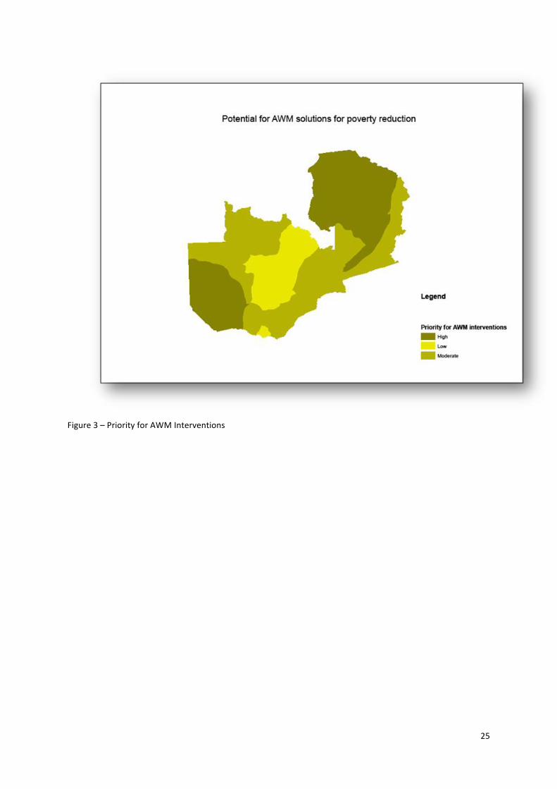
Figure3–PriorityforAWMInterventions
26
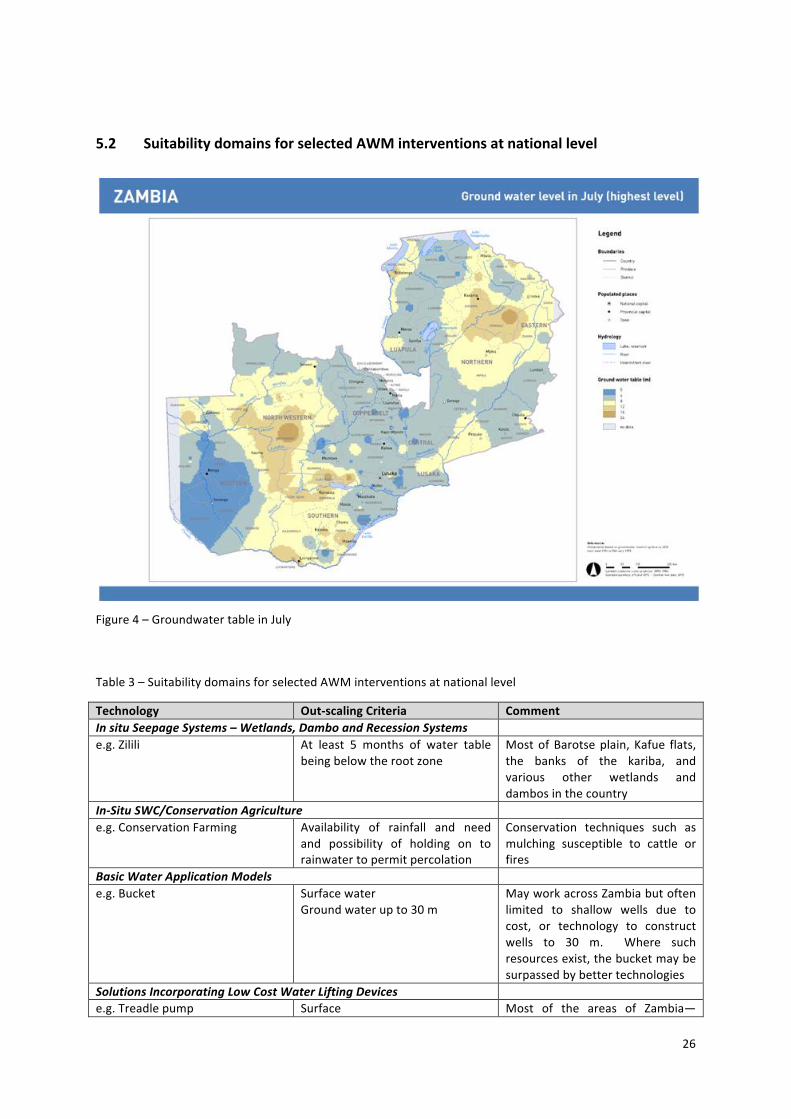
5.2 SuitabilitydomainsforselectedAWMinterventionsatnationallevel
Figure4–GroundwatertableinJuly
Table3–SuitabilitydomainsforselectedAWMinterventionsatnationallevel
Technology Out‐scalingCriteria CommentInsituSeepageSystems–Wetlands,DamboandRecessionSystems e.g.Zilili At least 5 months of water table
beingbelowtherootzoneMostofBarotseplain, Kafue flats,the banks of the kariba, andvarious other wetlands anddambosinthecountry
In‐SituSWC/ConservationAgriculture e.g.ConservationFarming Availability of rainfall and need
and possibility of holding on torainwatertopermitpercolation
Conservation techniques such asmulching susceptible to cattle orfires
BasicWaterApplicationModels e.g.Bucket Surfacewater
Groundwaterupto30mMayworkacrossZambiabutoftenlimited to shallow wells due tocost, or technology to constructwells to 30 m. Where suchresourcesexist,thebucketmaybesurpassedbybettertechnologies
SolutionsIncorporatingLowCostWaterLiftingDevices e.g.Treadlepump Surface Most of the areas of Zambia—
27
Groundwaterupto8metres market blue to yellow. Crocodileinfested rivers will cancel use ofsurfacewater.
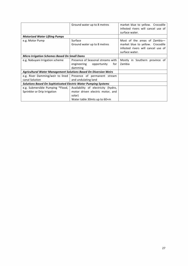
MotorizedWaterLiftingPumps e.g.MotorPump Surface
Groundwaterupto8metresMost of the areas of Zambia—market blue to yellow. Crocodileinfested rivers will cancel use ofsurfacewater.
MicroIrrigationSchemesBasedOnSmallDams e.g.NabuyaniIrrigationscheme PresenceofSeasonalstreamswith
engineering opportunity fordamming
Mostly in Southern province ofZambia
AgriculturalWaterManagementSolutionsBasedOnDiversionWeirs e.g. River Damming/weir to linedcanalSolution
Presence of permanent streamandundulatingland
SolutionsBasedOnSophisticatedElectricWaterPumpingSystems e.g. Submersible Pumping *Flood,SprinklerorDripIrrigation
Availability of electricity (hydro,motor driven electric motor, andsolar)Watertable30mtsupto60+m