WRF-NMM Nesting for Advanced Hurricane Forecasting … · WRF-NMM Nesting for Advanced Hurricane...
52
WRF-NMM Nesting for Advanced Hurricane Forecasting and other Mesoscale Modeling Applications S.G.Gopalakrishnan, Naomi Surgi and Dusan Jovic Environmental Modeling Center NCEP/NOAA/NWS, Washington, DC
Transcript of WRF-NMM Nesting for Advanced Hurricane Forecasting … · WRF-NMM Nesting for Advanced Hurricane...

WRF-NMM Nesting for Advanced Hurricane Forecasting and other Mesoscale Modeling
Applications
S.G.Gopalakrishnan, Naomi Surgi and Dusan Jovic
Environmental Modeling CenterNCEP/NOAA/NWS, Washington, DC
AcknowledgementsAcknowledgements
Robert Robert TuleyaTuleyaThomas BlackThomas BlackZavisaZavisa JanjicJanjicBrad FerrierBrad Ferrier
John John MichalakesMichalakes**
NCEP/EMC/NOAA, Washington D.C.NCEP/EMC/NOAA, Washington D.C.*NCAR, Boulder, Colorado*NCAR, Boulder, Colorado
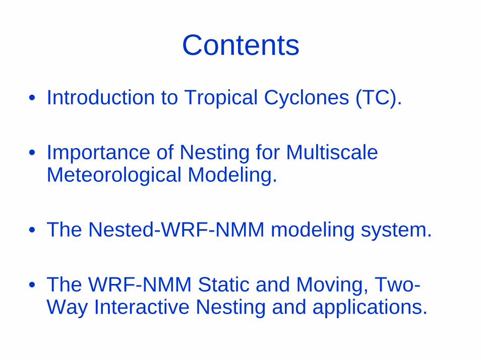
Contents
• Introduction to Tropical Cyclones (TC).
• Importance of Nesting for MultiscaleMeteorological Modeling.
• The Nested-WRF-NMM modeling system.
• The WRF-NMM Static and Moving, Two-Way Interactive Nesting and applications.
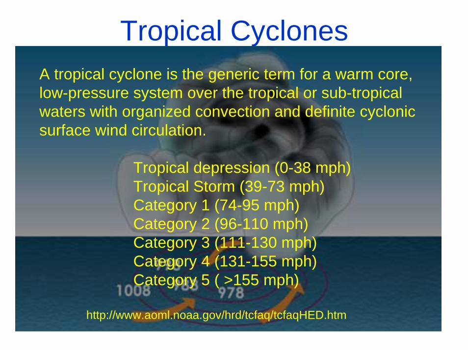
Tropical CyclonesA tropical cyclone is the generic term for a warm core, low-pressure system over the tropical or sub-tropical waters with organized convection and definite cyclonic surface wind circulation.
Tropical depression (0-38 mph)Tropical Storm (39-73 mph)Category 1 (74-95 mph)Category 2 (96-110 mph)Category 3 (111-130 mph)Category 4 (131-155 mph)Category 5 ( >155 mph)
http://www.aoml.noaa.gov/hrd/tcfaq/tcfaqHED.htm
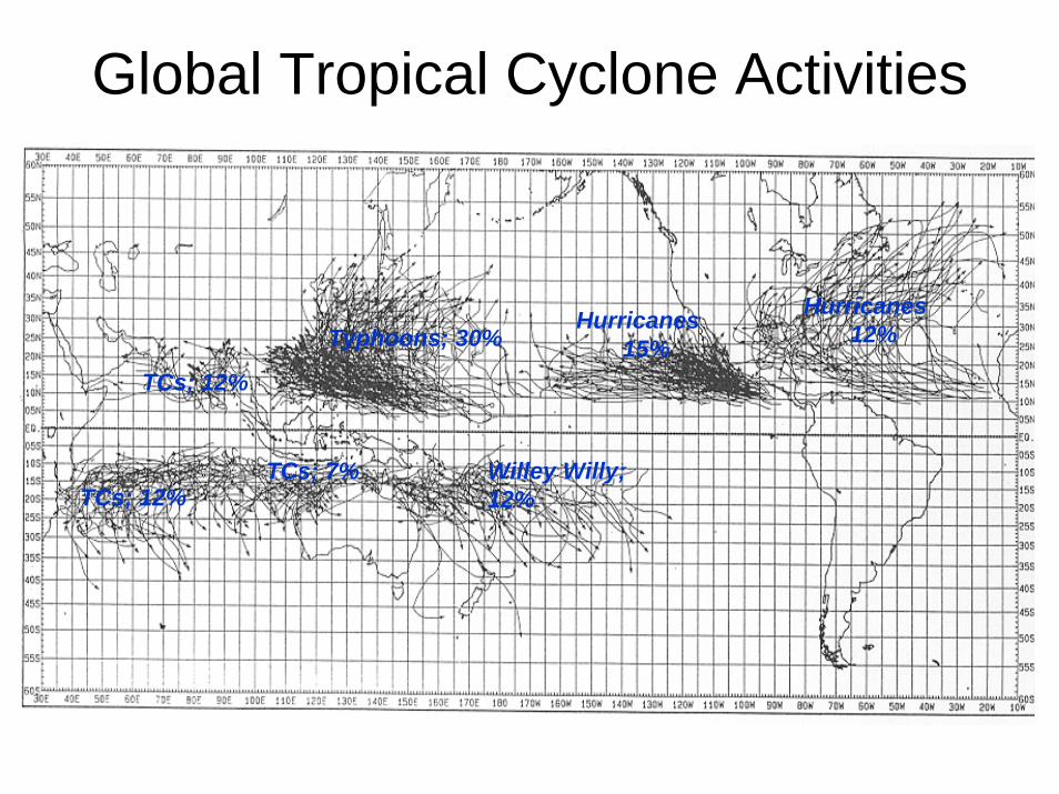
Global Tropical Cyclone Activities
Hurricanes12%Typhoons; 30%
Hurricanes15%
TCs; 12%
TCs; 12%Willey Willy; 12%
TCs; 7%
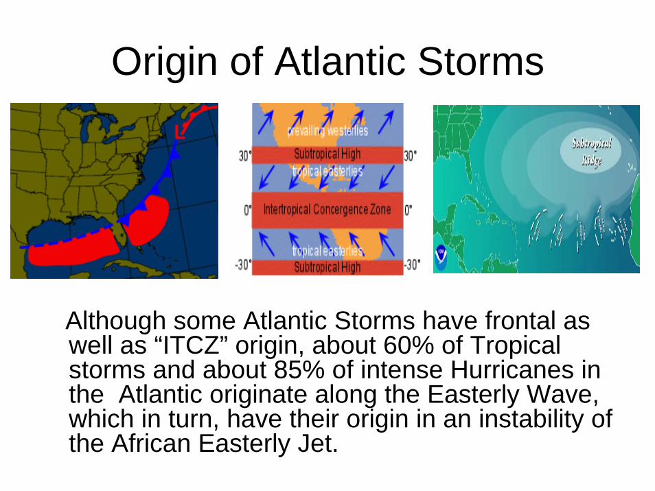
Origin of Atlantic Storms
Although some Atlantic Storms have frontal as well as “ITCZ” origin, about 60% of Tropical storms and about 85% of intense Hurricanes in the Atlantic originate along the Easterly Wave, which in turn, have their origin in an instability of the African Easterly Jet.

The Easterly Waves• Have wavelengths of about
2500 km. • Convergence/upward
motion on east side. • Travel from east to west at
10-20 knots, generally slower than the mean easterly current.
• In the Atlantic about 55-75 tropical waves are observed, but only 10-25% of these develop into a tropical depression or beyond. Clearly additional factors are required for genesis to occur.
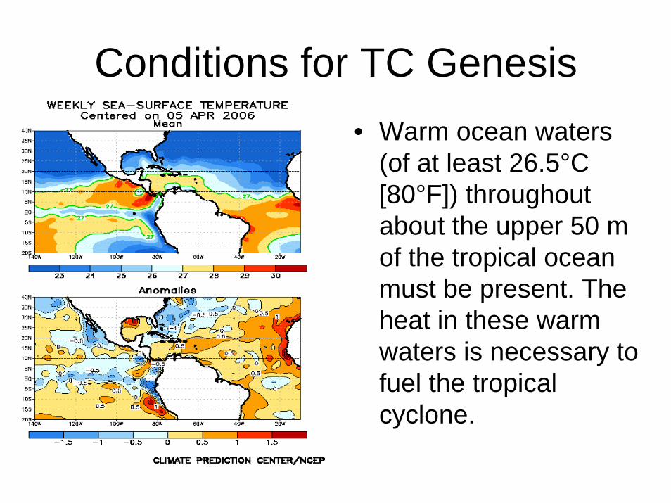
Conditions for TC Genesis• Warm ocean waters
(of at least 26.5°C [80°F]) throughout about the upper 50 m of the tropical ocean must be present. The heat in these warm waters is necessary to fuel the tropical cyclone.
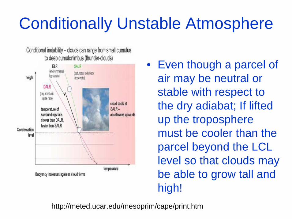
Conditionally Unstable Atmosphere
• Even though a parcel of air may be neutral or stable with respect to the dry adiabat; If lifted up the troposphere must be cooler than the parcel beyond the LCL level so that clouds may be able to grow tall and high!
http://meted.ucar.edu/mesoprim/cape/print.htm
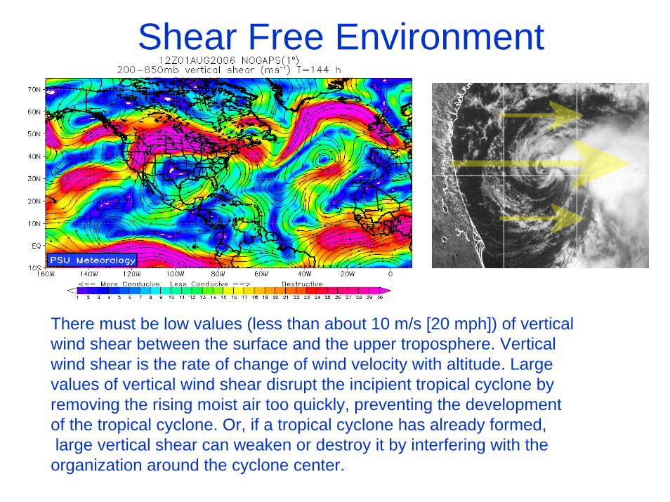
Shear Free Environment
There must be low values (less than about 10 m/s [20 mph]) of vertical wind shear between the surface and the upper troposphere. Verticalwind shear is the rate of change of wind velocity with altitude. Largevalues of vertical wind shear disrupt the incipient tropical cyclone byremoving the rising moist air too quickly, preventing the developmentof the tropical cyclone. Or, if a tropical cyclone has already formed,large vertical shear can weaken or destroy it by interfering with the organization around the cyclone center.
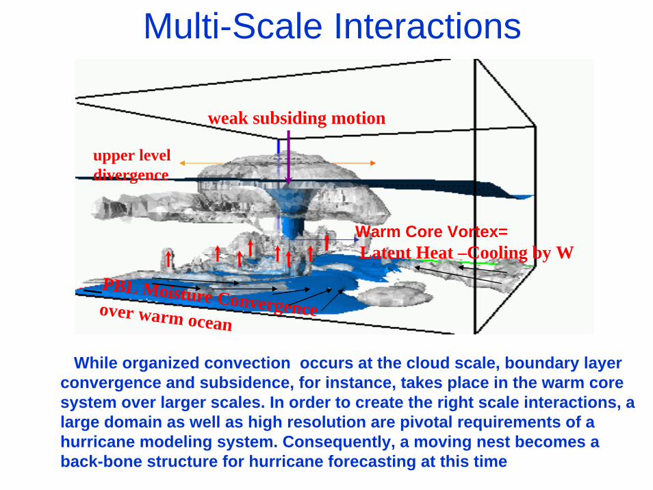
Multi-Scale Interactions
weak subsiding motion
upper level divergence
Warm Core Vortex=Latent Heat –Cooling by W
PBL Moisture Convergence over warm ocean
While organized convection occurs at the cloud scale, boundary layer convergence and subsidence, for instance, takes place in the warm core system over larger scales. In order to create the right scale interactions, a large domain as well as high resolution are pivotal requirements of a hurricane modeling system. Consequently, a moving nest becomes aback-bone structure for hurricane forecasting at this time

Tropical cyclone prediction relies on a subjective mix of computer guidance and human interpretation of the guidance and understanding of the tropical cyclone behavior.
To date, the NOAA’s Geophysical Fluid Dynamics Laboratory (GFDL), moving nested grid regional-scale model, the NOAA’s Environmental Modeling Center (EMC) Global Forecasting System, The NOGAPS, Navy model and the U.K.Met office model are the primary guidance for the tropical cyclone forecasting in the Atlantic and the Pacific basins.
Dramatic improvement in tropical cyclone track forecasts have occurred through advancements in high quality observations, high speed computers and improvements in dynamical models. Similar advancement now need to be made for tropical cyclone intensity, structure and rainfall prediction.
CLIPERCLIPER
GFSGFSTPCTPC
GFDLGFDL
Criterion for building regional-scale operational Hurricane forecasting system
• Speed and Accuracy• Failure is not an option• Analyzed boundary condition is NOT an option• Home Runs alone do not contribute to better
statistics
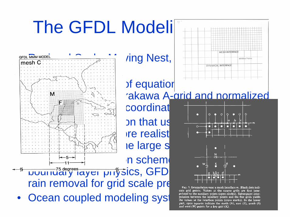
The GFDL Modeling System• Regional-Scale, Moving Nest, Atmospheric
Modeling System.• Hydrostatic system of equations formulated on a
latitude-longitude, Arakawa A-grid and normalized pressure (sigma_p) coordinate system.
• Advanced initialization that uses GFS analysis, yet an improved and more realistic storm vortex that blends in well with the large scale environment.
• Uses SAS convection scheme, GFS surface, boundary layer physics, GFDL radiation and simple rain removal for grid scale precipitation.
• Ocean coupled modeling system.
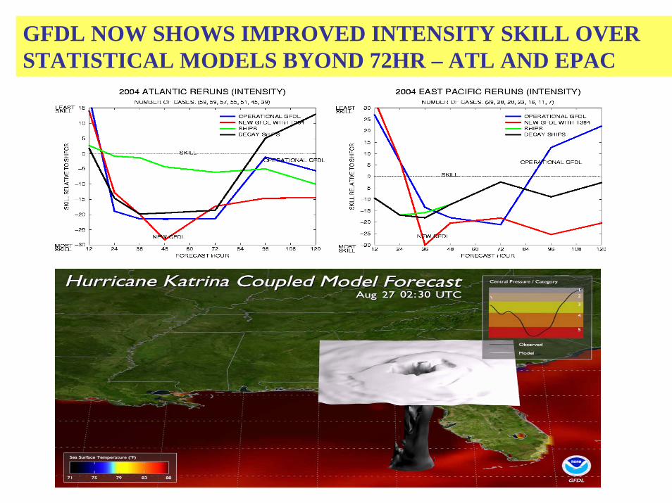
GFDL NOW SHOWS IMPROVED INTENSITY SKILL OVER STATISTICAL MODELS BYOND 72HR – ATL AND EPAC
We are now at the juncture of improving We are now at the juncture of improving intensity forecasts, where we were a decade intensity forecasts, where we were a decade ago in advancing hurricane track ago in advancing hurricane track forecasts……..forecasts……..
It is expected that ocean-coupled, high resolution, advanced, non-hydrostatic mesoscale modeling system may improve track as well as intensity predictions. NCEP’s Hurricane WRF-NMM is the next generation hurricane modeling system that will replace the GFDL system in 2007.

HurricaneHurricane--WaveWave--OceanOcean--SurgeSurge--Inundation Coupled Inundation Coupled Models (Models (Surgi’sSurgi’s implementation plan)implementation plan)
High resolution Coastal, Bay & Estuarine hydrodynamic model
HWRF
Atmosphere/oceanic Boundary Layer
HYCOM3D ocean circulationmodelWAVEWATCH III
Spectral wave model
NOAH LSM
NOSland and coastal waters
NCEPAtmosphere and Ocean
runoff
fluxes
wave fluxes
wavespectra
windsair temp. SST
currents
elevationscurrents
3D salinitiestemperatures
other fluxes
surgeinundation
radiativefluxes
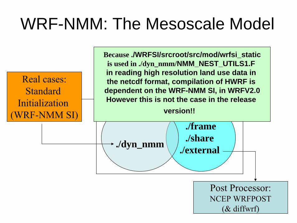
Real cases:Standard
Initialization (WRF-NMM SI)
./Registry ./inc
./Main
Post Processor:NCEP WRFPOST
(& diffwrf)
./phys./frame./share
./external ./dyn_nmm
WRF2.0WRF2.0
WRF-NMM: The Mesoscale Model
Because ./WRFSI/srcroot/src/mod/wrfsi_staticis used in ./dyn_nmm/NMM_NEST_UTILS1.F in reading high resolution land use data in the netcdf format, compilation of HWRF is
dependent on the WRF-NMM SI, in WRFV2.0However this is not the case in the release
version!!
External Data Used In Nested WRF-NMM Modeling System
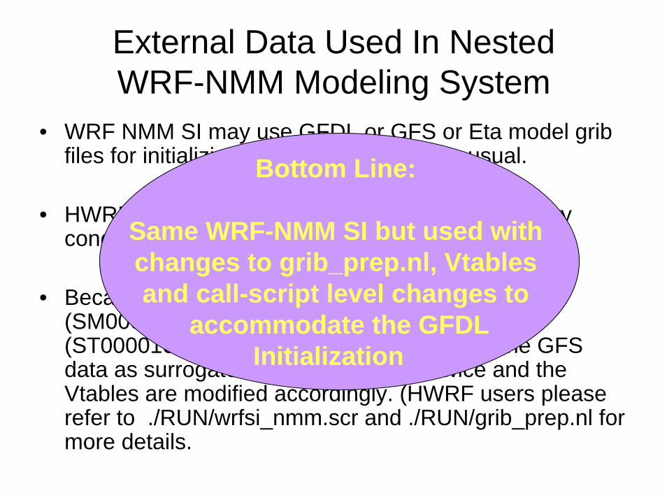
• WRF NMM SI may use GFDL or GFS or Eta model gribfiles for initializing the parent domain, as usual.
• HWRF uses GFDL grib files for initial and boundary conditions.
• Because GFDL grib files do not have soil moisture (SM000010 & SM010200) and soil temperature (ST000010 & ST010200) over land we use the GFS data as surrogate. grib_prep.pl is run twice and the Vtables are modified accordingly. (HWRF users please refer to ./RUN/wrfsi_nmm.scr and ./RUN/grib_prep.nl for more details.
Bottom Line:
Same WRF-NMM SI but used with changes to grib_prep.nl, Vtablesand call-script level changes to
accommodate the GFDLInitialization
STATIC/MOVING NEST SPECIFIC EXTERNAL DATA
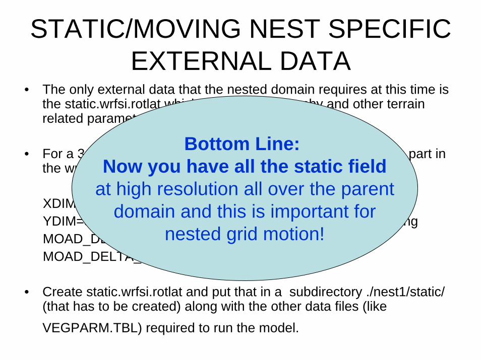
• The only external data that the nested domain requires at this time is the static.wrfsi.rotlat which contains topography and other terrain related parameters (such as the land sea mask).
• For a 3:1 parent:nest ratio, simply run the domain localization part in the wrfsi with the wfsi.nl set to:
XDIM=3*parent_xdim – 2 ! Factor 2 takes care of staggeringYDIM=3*parent_ydim – 2 ! Factor 2 takes care of staggering MOAD_DELTA_X=PARENT_X_RESOLUTION/3.0MOAD_DELTA_Y=PARENT_Y_RESOLUTION/3.0
• Create static.wrfsi.rotlat and put that in a subdirectory ./nest1/static/ (that has to be created) along with the other data files (like VEGPARM.TBL) required to run the model.
Bottom Line: Now you have all the static field
at high resolution all over the parentdomain and this is important for
nested grid motion!
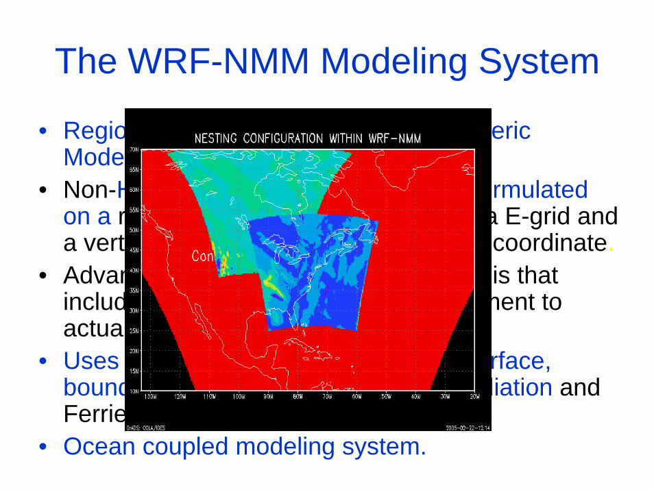
The WRF-NMM Modeling System
• Regional-Scale, Moving Nest, Atmospheric Modeling System.
• Non-Hydrostatic system of equations formulatedon a rotated latitude-longitude, Arakawa E-grid and a vertical, pressure hybrid (sigma_p-P) coordinate.
• Advanced HWRF,3D Variational analysis that includes vortex reallocation and adjustment to actual storm intensity.
• Uses SAS convection scheme, GFS surface, boundary layer physics, GFDL/GFS radiation and Ferrier Microphysical Scheme.
• Ocean coupled modeling system.
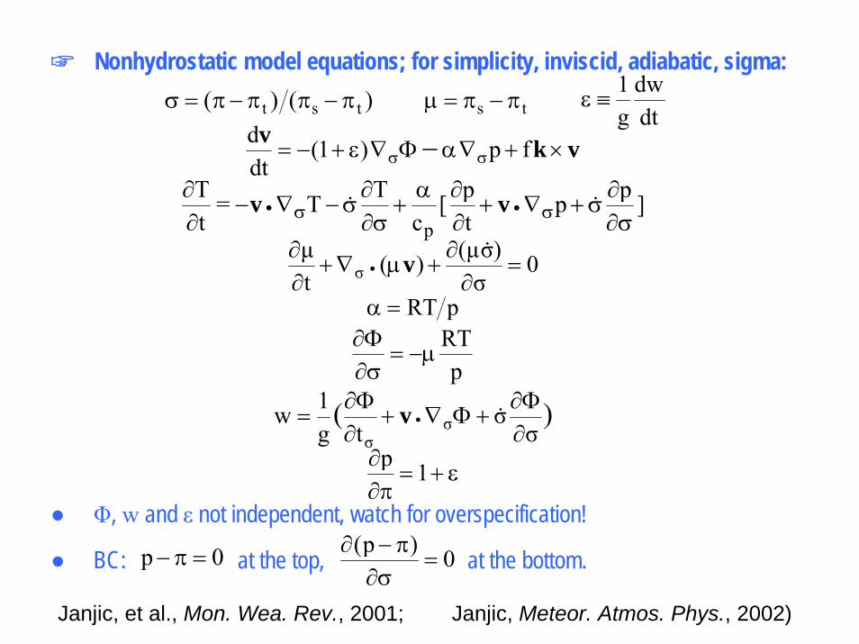
☞ Nonhydrostatic model equations; for simplicity, inviscid, adiabatic, sigma:)()( tst π−ππ−π=σ ts π−π=μ
dtdw
g1
≡ε
vkv×+∇αΦ∇ε+−= σσ − fp)1(
dtd
]pptp[
cTT=
tT
p σ∂∂
σ+∇+∂∂α
+σ∂∂
σ−∇−∂∂
σσ •• && vv
0σ
)σ(μ)(tμ
σ =∂
∂+μ∇+
∂∂
•&v
pRT=α
pRT
μ−=σ∂Φ∂
)(σ
σtg
1w σσ ∂
Φ∂+Φ∇+
∂Φ∂
= • &v
ε+=π∂∂ 1p
● Φ, w and ε not independent, watch for overspecification!
0)p(=
σ∂π−∂
● BC: 0p =π− at the top, at the bottom.
Janjic, et al., Mon. Wea. Rev., 2001; Janjic, Meteor. Atmos. Phys., 2002)
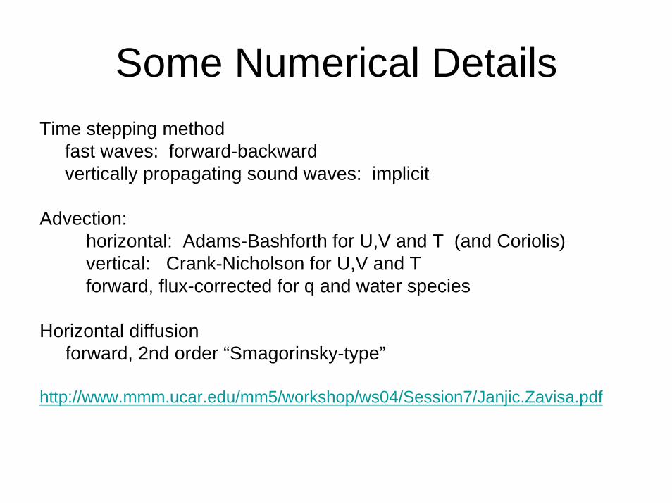
Some Numerical DetailsTime stepping method
fast waves: forward-backward vertically propagating sound waves: implicit
Advection: horizontal: Adams-Bashforth for U,V and T (and Coriolis)vertical: Crank-Nicholson for U,V and Tforward, flux-corrected for q and water species
Horizontal diffusionforward, 2nd order “Smagorinsky-type”
http://www.mmm.ucar.edu/mm5/workshop/ws04/Session7/Janjic.Zavisa.pdf

Salient Features: Telescopic E-Grid• All interpolations are done on a rotated
lat-lon, E-grid with the reference lat-lonlocated at the centre of the parent domain.
• Consequently the nested domain can be freely moved anywhere within the grid points of the parent domain, yet the nested domain lat-lon lines will coincide with the lat-lon lines of the parent domain at integral parent-to-nest ratio.
• This coincidence of grid points between the parent and nested domain eliminates the need for more complex, generalized remapping calculations in the WRF Advanced Software Framework and is expected to aid better distributed memory performance, and portability of the modeling system.

Salient Features: Telescopic E-Grid
• Large Scale portion of the flow may be easily separated from the small scale structure which may be advantageous for Hurricane analysis.
• However, as pointed out by Zhang et al.(1986; MWR), for the sake of smooth solutions across the interfaces it may be necessary to sacrifice mass and energy conservation across the interface in this approach. Nevertheless, for short-term numerical forecasts in which the use of appropriate model physics and the patterns to be forecast may be important than exact mass and energy conservation, as long as the mass (or energy) discrepancy at the interface is small.
020406080
100120
0 10 20 30 40Time (h)
Sca
lar (
%)
nest maximum nest mass
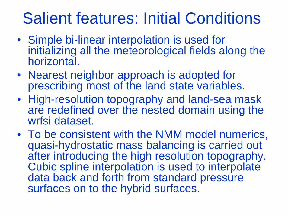
Salient features: Initial Conditions• Simple bi-linear interpolation is used for
initializing all the meteorological fields along the horizontal.
• Nearest neighbor approach is adopted for prescribing most of the land state variables.
• High-resolution topography and land-sea mask are redefined over the nested domain using the wrfsi dataset.
• To be consistent with the NMM model numerics, quasi-hydrostatic mass balancing is carried out after introducing the high resolution topography. Cubic spline interpolation is used to interpolate data back and forth from standard pressure surfaces on to the hybrid surfaces.

Salient features: WRF-NMM Nested Boundary Conditions
Because of the E-grid structure and the fact that the input interface(where the external boundaryconditions are prescribed) is wellseparated from dynamic interface(where the model integration iscarried out), boundaries are updatedat every time step of the parentdomain in a very similar manner asthe parent domain is updated at themass point from the external datasource.

LBCs: WRF-NMM Nest Specific!Along the horizontal direction, bi-linear interpolation is used for all progonostic variable (u,v,t,q,cwm,pd). However, geopotential height field (z3d), temperature (t) and moisture (q) are vertically interpolated (using cubic spline) from the hybrid surfaces on to standard pressure levels in the parent domain. Using interpolated information of the height fields from the parent domain, and high resolution topography over the nested domain, mass is adjusted and the new hybrid surfaces are reconstructed. Temperature and moisture which are available after horizontal interpolation from the parent domain at standard pressure levels are interpolated on to the new hybrid surfaces. The approach seem to be involved yet, as seen later, produces an effective way of updating the interface without much distortion or noise even while moving the teslesopic nest.
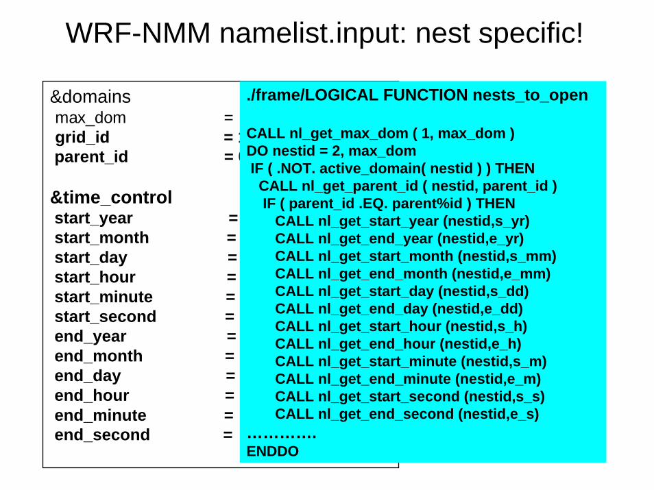
WRF-NMM namelist.input: nest specific!
&domainsmax_dom = 2, grid_id = 1, 2,parent_id = 0, 1,
&time_controlstart_year = 2005, 2005,start_month = 07, 07,start_day = 06, 06,start_hour = 06, 06,start_minute = 00, 00,start_second = 00, 00,end_year = 2005, 2005,end_month = 07, 07,end_day = 11, 11,end_hour = 06, 06,end_minute = 00, 00,end_second = 00, 00,
./frame/LOGICAL FUNCTION nests_to_open
CALL nl_get_max_dom ( 1, max_dom ) DO nestid = 2, max_domIF ( .NOT. active_domain( nestid ) ) THEN
CALL nl_get_parent_id ( nestid, parent_id ) IF ( parent_id .EQ. parent%id ) THEN
CALL nl_get_start_year (nestid,s_yr) CALL nl_get_end_year (nestid,e_yr) CALL nl_get_start_month (nestid,s_mm) CALL nl_get_end_month (nestid,e_mm) CALL nl_get_start_day (nestid,s_dd) CALL nl_get_end_day (nestid,e_dd) CALL nl_get_start_hour (nestid,s_h) CALL nl_get_end_hour (nestid,e_h) CALL nl_get_start_minute (nestid,s_m) CALL nl_get_end_minute (nestid,e_m) CALL nl_get_start_second (nestid,s_s) CALL nl_get_end_second (nestid,e_s)
………….ENDDO
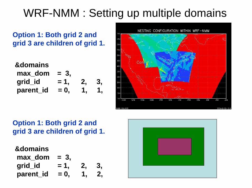
WRF-NMM : Setting up multiple domains
&domainsmax_dom = 3, grid_id = 1, 2, 3, parent_id = 0, 1, 1,
&domainsmax_dom = 3, grid_id = 1, 2, 3, parent_id = 0, 1, 2,
Option 1: Both grid 2 and grid 3 are children of grid 1.
Option 1: Both grid 2 and grid 3 are children of grid 1.
Possible only with one-way nests!
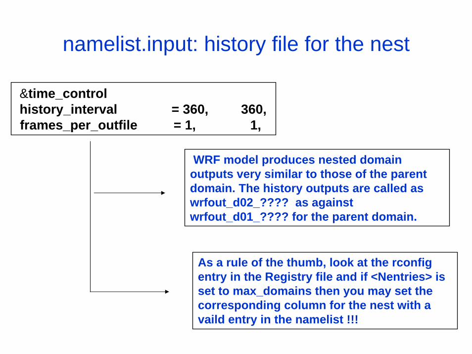
namelist.input: history file for the nest
&time_controlhistory_interval = 360, 360,frames_per_outfile = 1, 1,
WRF model produces nested domain outputs very similar to those of the parent domain. The history outputs are called as wrfout_d02_???? as against wrfout_d01_???? for the parent domain.
As a rule of the thumb, look at the rconfigentry in the Registry file and if <Nentries> is set to max_domains then you may set the corresponding column for the nest with a vaild entry in the namelist !!!
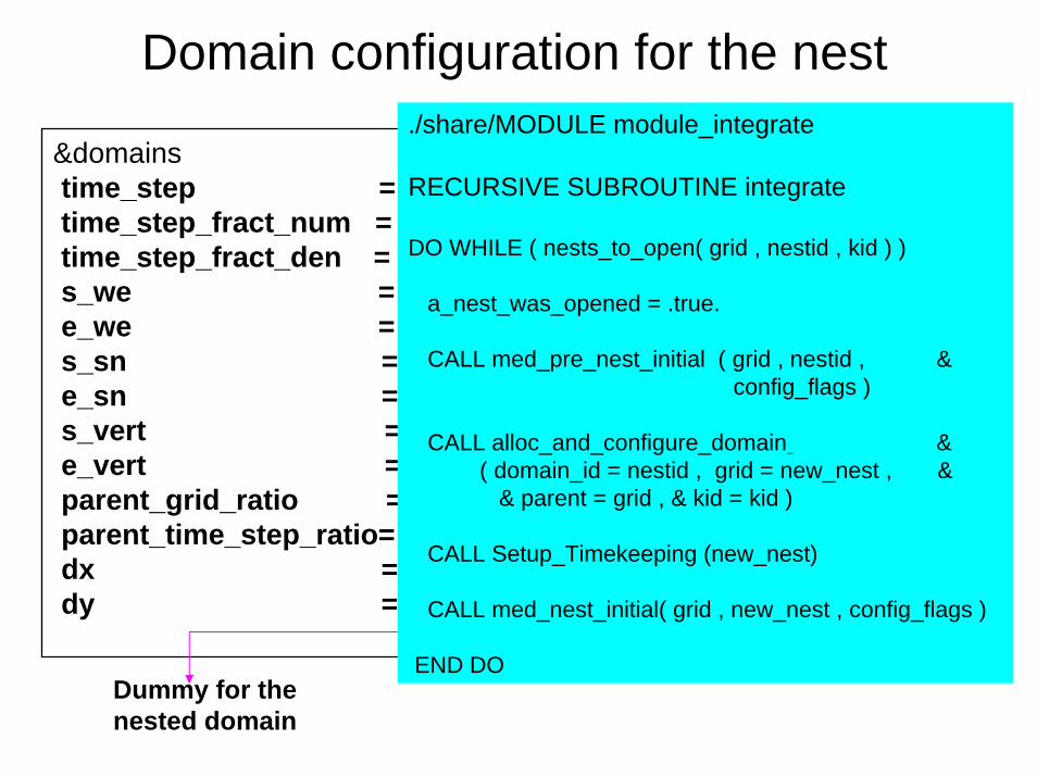
Domain configuration for the nest
&domainstime_step = 60,time_step_fract_num = 0,time_step_fract_den = 1,s_we = 1, 1,e_we = 160, 60,s_sn = 1, 1,e_sn = 310, 100,s_vert = 1, 1,e_vert = 43, 43,parent_grid_ratio = 1, 3,parent_time_step_ratio= 1, 3,dx = .18, 0.06,dy = .18, 0.06,
Dummy for the nested domain
./share/MODULE module_integrate
RECURSIVE SUBROUTINE integrate
DO WHILE ( nests_to_open( grid , nestid , kid ) )
a_nest_was_opened = .true.
CALL med_pre_nest_initial ( grid , nestid , &config_flags )
CALL alloc_and_configure_domain & ( domain_id = nestid , grid = new_nest , &
& parent = grid , & kid = kid )
CALL Setup_Timekeeping (new_nest)
CALL med_nest_initial( grid , new_nest , config_flags )
END DO
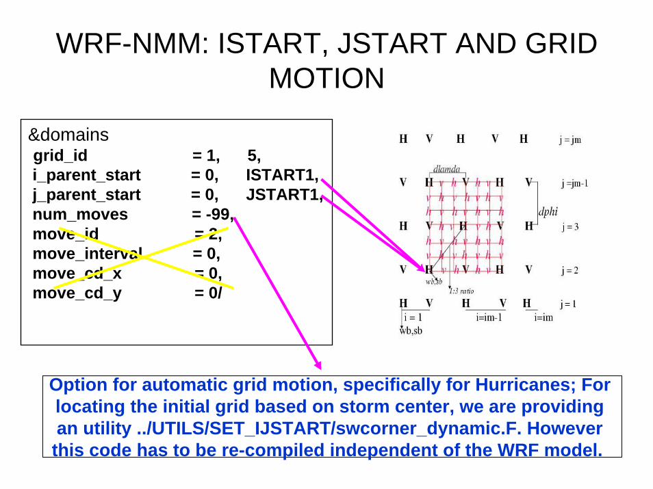
WRF-NMM: ISTART, JSTART AND GRID MOTION
&domainsgrid_id = 1, 5,i_parent_start = 0, ISTART1,j_parent_start = 0, JSTART1,num_moves = -99,move_id = 2,move_interval = 0,move_cd_x = 0,move_cd_y = 0/
Option for automatic grid motion, specifically for Hurricanes; For locating the initial grid based on storm center, we are providing an utility ../UTILS/SET_IJSTART/swcorner_dynamic.F. However this code has to be re-compiled independent of the WRF model.

Physics Options&physics
chem_opt = 0, 0,mp_physics = 5, 5,cu_physics = 2, 2,ra_lw_physics = 99, 99,ra_sw_physics = 99, 99,sf_sfclay_physics = 2, 2,sf_surface_physics = 99, 99,bl_pbl_physics = 3, 3,nphs = 5, 3,ncnvc = 5, 3,nrads = 60, 180,nradl = 60, 180,
Ferrier MicrophysicsBMJ/ SAS convection (option 4)GFDL long wave GFDL short waveMYJ/ GFDL sfclayer (option 88)NOAA LSM/ GFDL SLAB (opt 88)MYJ/ GFS PBL (option 3)
**** For Hurricane WRF we are constantly working in updating theparameterization schemes more consistent with the GFDL model which appears to have good skills in hurricane predictions. Not in repository.
In model time step unit
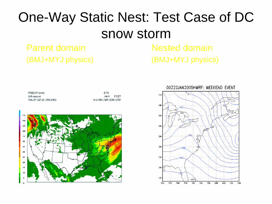
One-Way Static Nest: Test Case of DC snow storm
Parent domain(BMJ+MYJ physics)
Nested domain(BMJ+MYJ physics)

WRF-NMM: Torino OlympicsOne-way static nested runs (Jeff McQueen)
• WRF-NMM V2.1 using H-WRF nested grid configurations
• 24 h forecasts at 00 and 12 UTC• 90 mins w/ 64 tasks• 4 km Alps nest w/in 12 km Europe Domain• 50 levels
• Initialized with ½ degree GFS Pressure grids• Ferrier Microphysics No convective Param.• MYJ TKE, NOAH LSM
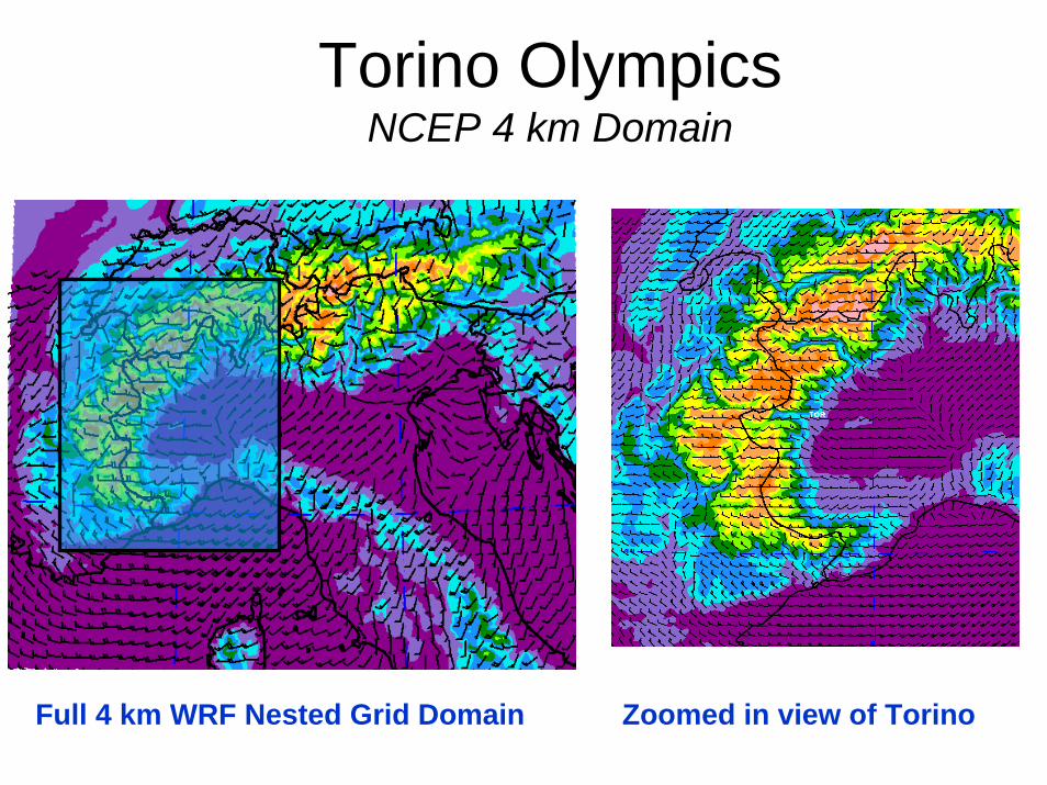
Torino OlympicsNCEP 4 km Domain
Full 4 km WRF Nested Grid Domain Zoomed in view of Torino
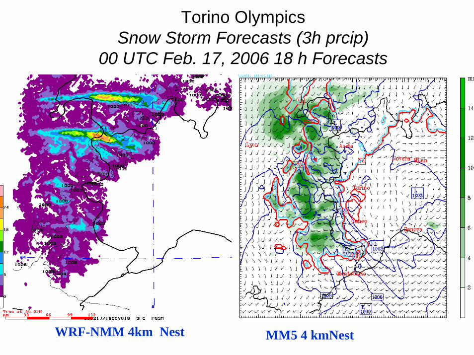
Torino OlympicsSnow Storm Forecasts (3h prcip)
00 UTC Feb. 17, 2006 18 h Forecasts
WRF-NMM 4km Nest MM5 4 kmNest
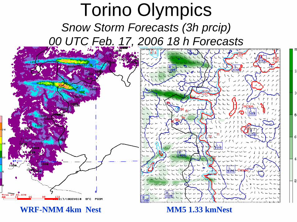
Torino OlympicsSnow Storm Forecasts (3h prcip)
00 UTC Feb. 17, 2006 18 h Forecasts
WRF-NMM 4km Nest MM5 1.33 kmNest
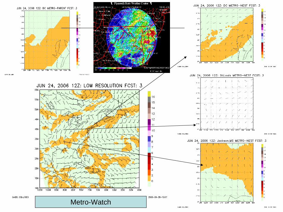
Metro-Watch
The WRF-NMM Moving Nest* For Hurricane Forecasting
*Not available in the repository
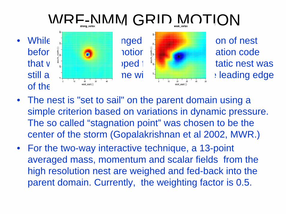
WRF-NMM GRID MOTION• While data was exchanged between the region of nest
before and after grid motion, bilinear interpolation code that was earlier developed for the one-way static nest was still applied, but this time with masking of the leading edge of the moving nest.
• The nest is "set to sail" on the parent domain using a simple criterion based on variations in dynamic pressure. The so called “stagnation point” was chosen to be the center of the storm (Gopalakrishnan et al 2002, MWR.)
• For the two-way interactive technique, a 13-point averaged mass, momentum and scalar fields from the high resolution nest are weighed and fed-back into the parent domain. Currently, the weighting factor is 0.5.
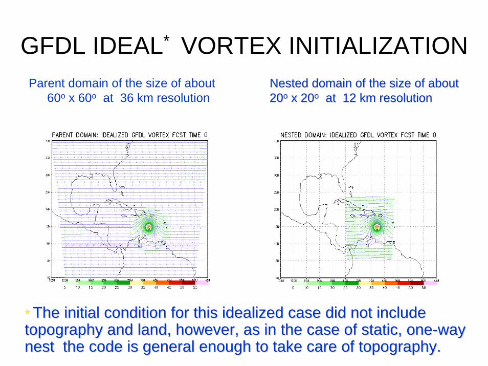
GFDL IDEAL* VORTEX INITIALIZATIONParent domain of the size of about
60o x 60o at 36 km resolution
* * The initial condition for this idealized case did not include The initial condition for this idealized case did not include topography and land, however, as in the case of static, onetopography and land, however, as in the case of static, one--way way nest the code is general enough to take care of topography.nest the code is general enough to take care of topography.
Nested domain of the size of about Nested domain of the size of about 2020oo x 20x 20oo at 12 km resolutionat 12 km resolution
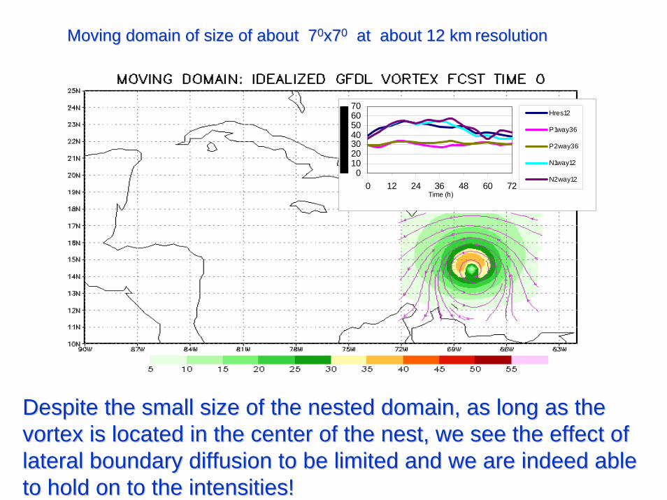
Moving domain of size of about 7Moving domain of size of about 700x7x700 at about 12 kmat about 12 km resolutionresolution
Despite the small size of the nested domain, as long as the Despite the small size of the nested domain, as long as the vortex is located in the center of the nest, we see the effect ovortex is located in the center of the nest, we see the effect of f lateral boundary diffusion to be limited and we are indeed able lateral boundary diffusion to be limited and we are indeed able to hold on to the intensities!to hold on to the intensities!
010203040506070
0 12 24 36 48 60 72Time (h)
Hres12
P1way36
P2way36
N1way12
N2way12

HWRFMoving nested runs
• WRF-NMM V2.0 using HWRF• 5 days of forecasts at 06 and 18 UTC• 55 mins w/ 72 tasks• 9 km moving nest w/in 27 km parent domain of
about 600x600
• 42 levels
• Initialized with 1/6 degree GFDL Pressure grids• Ferrier Microphysics; SAS convection scheme• GFS PBL and GFDL slab
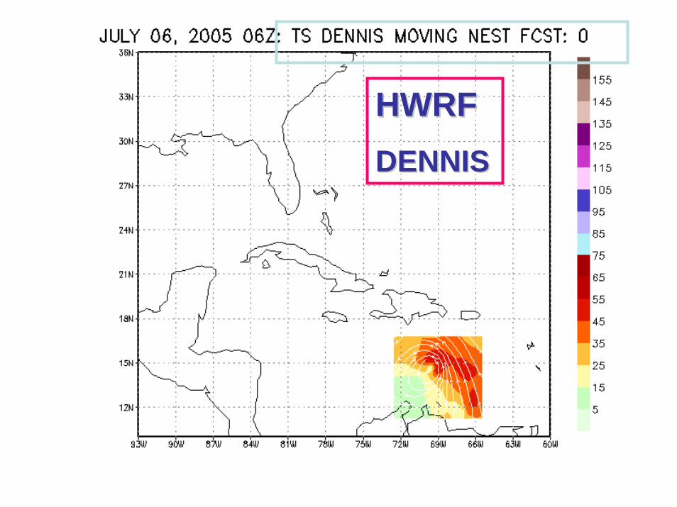
HWRFHWRFDENNISDENNIS
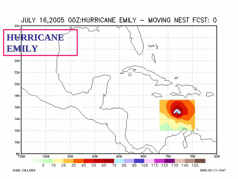
HURRICANE HURRICANE EMILY EMILY

HWRF
Hurricane
Katrina

HWRF HWRF
Hurricane WilmaHurricane Wilma


On Going Efforts…
Advanced Vortex Initialization for HWRFHWRF-Wavewatch couplingHWRF-Ocean Coupling (HYCOM)Use of static nest for Urban and dispersion applicationsTwo-way interaction is now available in NMM-HWRF2.0 and has to be migrated into the repository version (i.e. WRFV2.1)
References(1) NCEP's Two-way-Interactive-Moving-Nest WRF-NMM modeling system
for Hurricane Forecasting. 27th Conference on Hurricanes and Tropical Meteorology, Monterey, CA, April 24-29, 2006. S.G. Gopalakrishnan, N. Surgi, R. Tuleya, and Z. Janjic. (http://ams.confex.com/ams/27Hurricanes/techprogram/paper_107899.htm)
(2) An Operational Multiscale Hurricane Forecasting System. Monthly Weather Review, 2002, Vol. 130, No. 7, pp. 1830–1847. S.G Gopalakrishnan et al.
(3) HWRF: An intorduction to the NMM-WRF modeling system. Hurricane WRF (HWRF) Tutorial - October 26 & 27, 2004. S.G.Gopalakrishnan(http://www.emc.ncep.noaa.gov)
(4) Nesting in WRF 2.0, WRF/MM5 Joint Workshop, Boulder, June 22-25, 2004. David Gill, John Michalakes, Jimy Dudhia, William Skamarockand S.G.Gopalakrishnan,