WP3 / Action 3 - shape-ipaproject.eu action 3.2 - reports...REGIONEPUGLIA WP3 / Action 3.2...
12
REGIONE PUGLIA 1 WP3 / Action 3.2 “Testing some provisions of the ICZM Protocol through local/regional demonstration projects” The implementation of the Article 8 of the ICZM Protocol in the Puglia Region: proposal for the individuation of the set-back zone in the pilot area of Torre Guaceto (Brindisi) FRAMEWORK AND METHODOLOGY
-
Upload
nguyenngoc -
Category
Documents
-
view
212 -
download
0
Transcript of WP3 / Action 3 - shape-ipaproject.eu action 3.2 - reports...REGIONEPUGLIA WP3 / Action 3.2...

REGIONE PUGLIA
1
WP3 / Action 3.2 “Testing some provisions of the ICZM Protocol through local/regional demonstration projects”
The implementation of the Article 8 of the ICZM Protocol in the Puglia Region: proposal
for the individuation of the set-back zone in the pilot area of Torre Guaceto (Brindisi)
FRAMEWORK AND METHODOLOGY

REGIONE PUGLIA
WP3 / Action 3.2 “Testing some provisions of the ICZM Protocol through local/regional demonstration projects”
2
Table of Content 1. Foreword 3 2. The coastal area in the frame of the Puglia planning system 3 3. Set-back zone definition 3 3.1 The existing tools for the delimitation of coastal area of public property and subject to constraints 4 3.2 Proposed methodology for drawing the set-back zone baseline 5 3.3 Indications for the set-back zone tracing in Puglia 9 4. Details on activities for the evaluation of the Art. 8 applicability in the pilot area 10 5. Closing remarks, implementation and mainstreaming process 11 6. References 11

REGIONE PUGLIA
WP3 / Action 3.2 “Testing some provisions of the ICZM Protocol through local/regional demonstration projects”
3
1. Foreword The present document briefly illustrates the proposal of methodology to be used for the individuation, according to the Article 8 of the ICZM Protocol, of the coastal set-back zone in a pilot area of the Puglia Region. It concerns two main aspects: - the evaluation of the state of the art of regional planning instruments for the governance of the coastal
system; - the proposed methodologies for the individuation and tracing of the set-back zone in a pilot area of the
Puglia Region. 2. The coastal area in the frame of the Puglia planning system The current governance of the marine-coastal zone in Puglia is mainly based on laws and regional regulations. The main are:
- Thematic Territorial Urban Plan for the Landscape (PUTT/P), approved by resolution No. 1748 of the Puglia Regional Council dated December 15, 2000;
- Regional Law n. 17 “Rules governing the protection and use of coast”, dated June 23, 2006; - Regional Law n. 20 “Rules for landscape planning” dated October 7, 2009; - Regional Water Plan (PRA), approved by resolution No. 230 of the Puglia Regional Council dated
October 20, 2009; - Regional Coast Plan (PRC), approved by resolution No. 2273 of the Puglia Regional Council dated
October 13, 2011; - Regional Territorial Landscape Plan (PPTR), approved by the Puglia Government the 11 January,
2010 (now under submission to the Italian Government). The most important for the purpose of the ICZM are the Regional Law n. 20 “Rules for landscape planning”, the Regional Law n. 17 “Rules governing the protection and use of coast”, and finally the Regional Coast Plan (PRC). All the mentioned acts includes features linked to the ICZM concept, as the protection and conservation of coastal biodiversity, the coastal planning, the vulnerability/sensibility of the on-shore coastal areas. With regard the Regional Coast Plan obligations, it is mandatory for the coastal municipalities the draft of the Municipal Coast Plans within four months from the date of approval of the PRC (resolution No. 2273 of the Puglia Regional Council dated October 13, 2011). The Municipal Coast Plans need to be prepared according to the guidelines and rules provided by the PRC (coast vulnerability, sensibility, the ratio between the surfaces granted to private and the public domain surfaces, etc.). 3. Set-back zone definition In order to define the set-back zone it’s necessary to draw a baseline, as it has been discussed in the document: “Implementation of coastal setbacks: an explanatory report of Article 8 of the ICZM Protocol”, transmitted by the WP3 leader and to which we refer.
REGIONE PUGLIA
WP3 / Action 3.2 “Testing some provisions of the ICZM Protocol through local/regional demonstration projects”
4
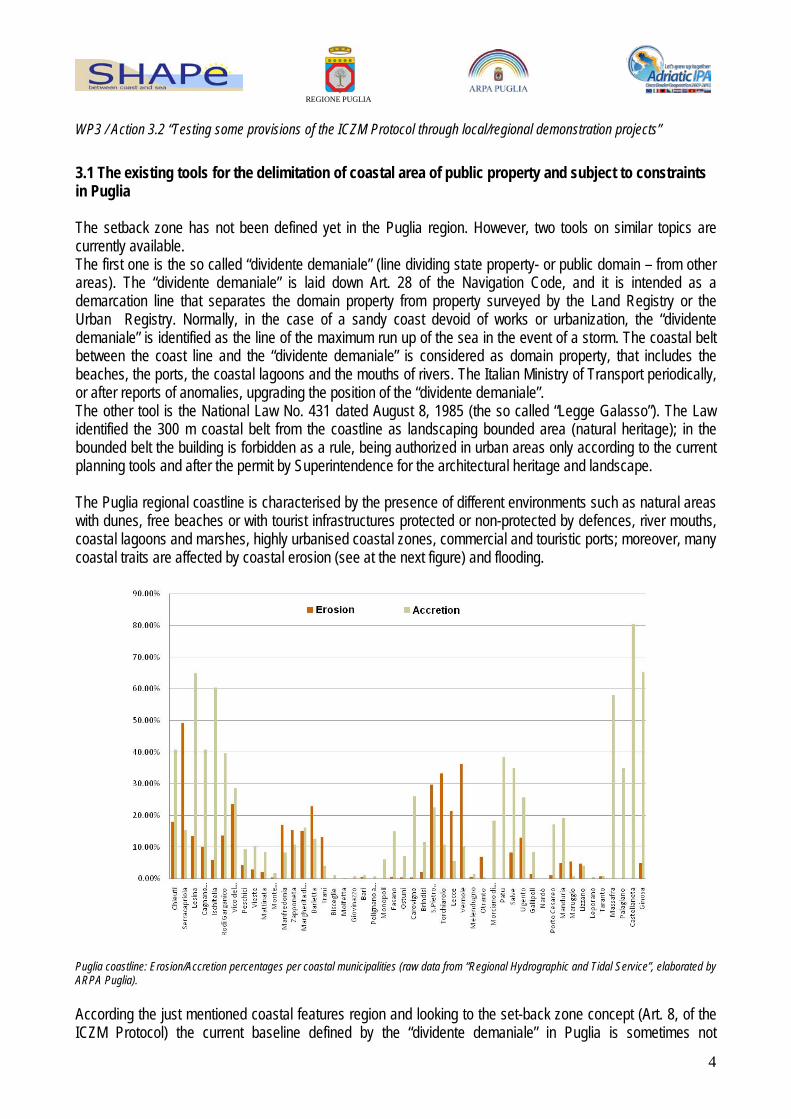
3.1 The existing tools for the delimitation of coastal area of public property and subject to constraints in Puglia The setback zone has not been defined yet in the Puglia region. However, two tools on similar topics are currently available. The first one is the so called “dividente demaniale” (line dividing state property- or public domain – from other areas). The “dividente demaniale” is laid down Art. 28 of the Navigation Code, and it is intended as a demarcation line that separates the domain property from property surveyed by the Land Registry or the Urban Registry. Normally, in the case of a sandy coast devoid of works or urbanization, the “dividente demaniale” is identified as the line of the maximum run up of the sea in the event of a storm. The coastal belt between the coast line and the “dividente demaniale” is considered as domain property, that includes the beaches, the ports, the coastal lagoons and the mouths of rivers. The Italian Ministry of Transport periodically, or after reports of anomalies, upgrading the position of the “dividente demaniale”. The other tool is the National Law No. 431 dated August 8, 1985 (the so called “Legge Galasso”). The Law identified the 300 m coastal belt from the coastline as landscaping bounded area (natural heritage); in the bounded belt the building is forbidden as a rule, being authorized in urban areas only according to the current planning tools and after the permit by Superintendence for the architectural heritage and landscape. The Puglia regional coastline is characterised by the presence of different environments such as natural areas with dunes, free beaches or with tourist infrastructures protected or non-protected by defences, river mouths, coastal lagoons and marshes, highly urbanised coastal zones, commercial and touristic ports; moreover, many coastal traits are affected by coastal erosion (see at the next figure) and flooding.
Puglia coastline: Erosion/Accretion percentages per coastal municipalities (raw data from “Regional Hydrographic and Tidal Service”, elaborated by ARPA Puglia). According the just mentioned coastal features region and looking to the set-back zone concept (Art. 8, of the ICZM Protocol) the current baseline defined by the “dividente demaniale” in Puglia is sometimes not

REGIONE PUGLIA
WP3 / Action 3.2 “Testing some provisions of the ICZM Protocol through local/regional demonstration projects”
5
appropriate. Moreover, the 300 m coastal belt identified by the so called “Legge Galasso” keep in to the account a generic “safe area” without any technical-scientific advices. 3.2 Proposed methodology for drawing the set-back zone baseline The proposed methodology for drawing the set-back zone baseline is based on the integration of results from four different methods/approaches applied in the pilot area of Torre Guaceto-Apani (Brindisi, Italy). Two of the methods are characterised by the modeling approach (run-up and extreme flooding estimation by mathematical models), the others by the empiric evaluation of the effect of strong storm surges on the coastal zone (direct effect of the run-up and flooding on the coastal environments). The four proposed methods reported below came from the inter-institutional collaboration among ARPA Puglia, the Polytechnic University of Bari (LIC Laboratory) and the University of Bari – Department of Earth and Geo-Environmental Sciences. - Run-up estimation by mathematical model. This implemented approach will provide the estimation of the maximum sea level rise on the coast due to the simultaneous occurrence of the phenomena of wave set-up, wave run-up, wind set-up and tides. The first step in wave setup and run-up estimation will be the offshore meteomarine climate definition. For the considered site (Torre Guaceto-Apani) an offshore wave series is not available, therefore we will refer to the wave series collected from 01/07/1989 to 31/12/2007 by a directional wave buoy moored off the coast of Monopoli (very close to the coast of Torre Guaceto). The observed time series will be transferred offshore Torre Guaceto-Apani using a standard technique. Using a spectral wave model (SWAN - Simulating Waves Nearshore) the offshore extreme waves with a return period Tr equal to 50 years will be propagated towards the coast. In order to estimate the maximum sea level near the coast, the SWAN model output will be used to calculate wave set-up and wave run-up. Wave setup is the change in mean water level due to the presence of waves. This setup is present in and near the coastal surf zone, and is evidenced by a rise in mean sea level above the still water line. Wave set-up calculation will be performed using a mathematical model called SBEACH32, developed by the Coastal Engineering Research Center of the U.S. Army Corps of Engineers. The SBEACH32 model is able to reproduce irregular waves propagation and relative wave set-up. The software will be applied along transects starting offshore from a depth of -100 m to the emerged beach. Wave run-up is the maximum vertical extent of wave uprush on a beach or structure above the still water level (SWL). Wave run-up is often indicated by Ru2%, that is the run-up level which is exceeded by two per cent of the incoming waves. Note that the number of exceedance is here related to the number of incoming waves and not to the number of run-up levels.

REGIONE PUGLIA
WP3 / Action 3.2 “Testing some provisions of the ICZM Protocol through local/regional demonstration projects”
6
The general formula that can be applied for wave run-up on beaches with very mild profiles is given by:
opβfbs2%u H1.6R ξγγγ=
where: γb = reduction factor for a berm; γf = reduction factor for roughness on the slope; γ =reduction factor for the angle of wave attack;
ϕop =Iribarren number or surf similarity parameter defined as
0LH
tg
sop
αξ = where L0 is the deep water wavelength
and α is the beach slope.
Several formulas for predicting wave run-up will be investigated in the study (Massel e Pelinovsky, 2001; CERC, 2002, etc.) and results will be compared. The wind set-up is the vertical rise in the still water level near shore caused by wind stresses on the surface of the water. Calculation of water level is a function of fetch length, water depth and wind speed. As extra parameters the approach angle towards the coast can be entered. The maximum tide levels in the examined zone will be extracted from data recorded in the period 2007 - 2011 by the tide gauge located in Brindisi, that is part of Puglia Region meteomarine monitoring network. - Maximum Flooding (Tsunami impact) estimation by mathematical model
With another approach, in the last decade the study of geological evidence in the coastal areas of the Mediterranean Sea - levels out of place, washover fans, and fields / berms of megablocks - has allowed the recognition of the impact of tsunamis also along the coasts where their impact was not known (eg: Mastronuzzi and Sansò, 2000, 2004, 2007; Mastronuzzi and Pignatelli., 2012; Mastronuzzi, 2010). At least 13 events among those recognized have hit the coast of Puglia, among them the most tragic event surely was
. Recent experiences of flooding in Philippines (2004), Louisiana (2005), Bangladesh (2007), and Myanmar (2008) point out, with mention of tsunamis, such as the occurrence of these extreme floods is able to cause damage even in countries that are technologically and socially advanced. The tsunamis in particular, by their nature, can affect any coastal area of the planet with a minimum notice period, the Mediterranean is no stranger to such events (Mastronuzzi, 2010). The increasing human presence and activity on the coastal areas makes them vulnerable to the occurrence of events of great impact and low frequency: tsunami tidal waves and exceptional storm surges. Through historical, archival and documentary surveys, catalogs of tsunamis that hit the coasts of the Mediterranean have been reported (eg: Guidoboni & Comastri, 2007); at least 27 events have hit the Puglia. In these catalogs the latest events are dated in the last century for both the Adriatic and the Ionian coast.

REGIONE PUGLIA
WP3 / Action 3.2 “Testing some provisions of the ICZM Protocol through local/regional demonstration projects”
7
one that struck the area of Lesina 30 July 1627 (Gianfreda et al., 2001; De Martini et al., 2003 ; Mastronuzzi and Sansò, 2012) (see at the next figure).
Washover fans from tsunami in the lake of Lesina (Mastronuzzi and Sansò, 2012.). Unlike the sandy coasts, in which the conservative environments as the back-dune areas preserve the effects of extreme waves superimposed to each other, along the rocky coasts only the effects of the most recent ones are preserved, while the oldest can be deleted or hidden (Mastronuzzi and Sansò, 2000; 2004; Mastronuzzi et al., 2006). The study of the accumulation of large rocky blocks include the attempt to discriminate the agent responsible for their transport and accumulation as a function of the size and weight of the blocks. The blocks of southern Puglia, for example, were also accumulated from exceptional storms (Mastronuzzi & Sansò, 2004; Pignatelli et al., 2006). Based on the morphological features of the seabed and coastal areas, adapting hydrodynamic formulas and relevant mathematical models (eg: Nott, 2003, Goto et al., 2007) was therefore constructed a morphodynamic model which estimates the extent of extreme flooding and risk along the coast (Pignatelli et al., 2009; Piscitelli et al., 2009). It is expressed by the formula (Pignatelli et al., 2009):
Xmax = D + (Ht – hc)1.33 n-2kcosα
In this equation, Xmax is the maximum inundation of a tsunami with wave height Ht known, function of the distance D of blocks from the edge of the cliff hc, the slope α of the coastal strip, the number of Manning (ie coastal roughness) and the coefficient k constant for the tsunami. The formula is derived from a deterministic approach: along the rocky coasts of Puglia - as a bit 'all over the world - have been clearly recognized blocks from the sea (traces of fouling organisms, forms of erosion typical of the intra-tidal zone), characterised by "out of the ordinary" sizes, at inland distances from the coastline "out of the ordinary." The digital relief of the blocks by Laser Scanner technologies allowed to reconstruct with extreme detail both the shape of the blocks, the weighted size of the axes -a,-b and-c, and the weight (Marsico et al., 2009). In fact, from the size of the blocks, considering the forces acting on them due to the wave impact and the consequent inland transport, it is possible to derive the height of the wave impacting:
Ht ≥ [0,5 c (ρb – ρw /ρw)]/CL

REGIONE PUGLIA
WP3 / Action 3.2 “Testing some provisions of the ICZM Protocol through local/regional demonstration projects”
8
where –c is the measure of the height of the exposed face of the block to the wave, ρb is the density of the rock forming the block, ρw is the water density (1.02 g/cm3) , and CL is the lift coefficient (0,178) (Nott, 2003; Pignatelli et al., 2009). Moreover, a methodology was developed for the relief of the coastal roughness affecting the inland flow of the marine waters, using the Laser Scanner technologies; this method allows to measure the current value of the Manning's coefficient, determining a possible future event (Pignatelli et al., 2010a; Pignatelli et al., 2010b). The last step for the definition of the maximum flooding is the development of a GIS tool, that automatically allows the definition of the maximum flooding baseline knowing the parameters of the impacting wave (direction of origin and height ), and the environmental ones (morphology of the seabed and the coastline, slope and roughness, height of the cliff). - Empirical estimation of run-up level by means of visual check in the coastal belt. Strong storm surges can bring on the coast a large amount of materials of different size, weight and density. Extreme events can move rock blocks also (see at the previous described method), but most of times a good indicator of the run up level after the storm is the presence of large pebbles and relatively large (and heavy) tree trunks. In the Torre Guaceto-Apani coastal area the strongest storms (from N, NW and NE directions) occur during winter as a rule, thus the inspections on the coastal belt after the storm surges and the positioning (by GPS) of the heavy materials transported by the waves can give a rough estimation of run up level.
Tree trunk carried by storm surges on the beach of Torre Guaceto during the winter 2011-2012.
Linking several detections of this type along a coastal trait we can obtain an empirical representation of the run up line to be used as GIS layer.

REGIONE PUGLIA
WP3 / Action 3.2 “Testing some provisions of the ICZM Protocol through local/regional demonstration projects”
9
- Empirical estimation of run-up level and flooding in the coastal area by means of vegetational aspects. The presence and distribution of plants along the coast are influenced by several factors including variations in sea level (storm surges, tides alternation), salinity, prevailing winds, insolation, temperatures and composition of the substrate. The plants through special physiological adaptations tend to organize themselves in stable communities that are distributed across the coastal belt along a spatial gradient from inland to shoreline with an increasingly specialized organization characterized by typical species and a stable floristic composition. The floristic associations that can be found in a certain spatial distribution is defined as “vegetation series” or sigmetum, and each single association is called “vegetation series step”. Starting from the sea towards the land, the first floristic association found after the shoreline is the Cakile maritima strandline community, that consists of a few pioneer species, Cakile maritima, Salsola kali, Calystegia soldanella. The presence/absence of the Cakile maritima strandline community species will be considered for the rough estimate of the run up level in the sandy coast of the Torre Guaceto-Apani pilot area, while the species Limonium sp., Arthrocnemum perenne e Crithmum maritimum will be used along the low rocky coast traits. The study of vegetation will be carried out according to the classical phytosociological approach (Braun-Blanquet, 1964). Finally, the presence of the target species will be geo-referenciated in order to obtain a GIS representation of the estimated “vegetational” baseline to be used for the integrated tracing of the set-back zone. 3.3 Indications for the set-back zone tracing in Puglia The estimations from the four different methods will be mapped, integrated and cross-validated, in order to obtain the most reliable representation of the experimental set-back baseline.
Example of the set back baseline (and buffer zone) resulted from the empirical estimation of run-up level by means of visual check.

REGIONE PUGLIA
WP3 / Action 3.2 “Testing some provisions of the ICZM Protocol through local/regional demonstration projects”
10
The resulting set-back baseline in the Torre Guaceto-Apani pilot area will be used for the tracing of the set-back zone, simply created as a 100 meters buffer of the same baseline in the first approximation. In some cases it will be adjusted (the second approximation) in order to comprehend the most relevant morphologic coastal features, in particular dunes and coastal woods located outside ‘special protection areas’, as indicated in the ICZM Protocol. Finally, the resulting set back zone will be compared in a GIS representation with the “dividente demaniale” and the “Legge Galasso” landscaping bounded area. 4. Details on activities for the evaluation of the Art. 8 applicability in the pilot area The analysis will be focused on the Torre Guaceto coastal belt. Once defined and validated the set-back zone following the above described methodology, the activity will be developed according with the following three steps producing a final report on the applicability of Art. 8 in the pilot area.
Step 1. Analysis of current land uses and spatial planning instruments regulations, individuation of “criticalities” in the light of the Art.8 provisions Land Use cartography: - Urbanised territory - Industrial areas - Infrastructures and facilities - Harbours - Agricultural areas - Natural areas Individuation, within the set-back zone, of criticalities in the light of the Art.8 provisions (with particular reference to non-building or building strict constraints).
Step 2. Evaluation of urban planning previsions and regulations (if existing) on the “criticalities” (if individuated) - Building and infrastructural interventions - Industrial areas enlargements - New dockyards, new port facilities areas, etc. - Use destination changes of agricultural areas - Modifications in or nearby natural reserve areas Step 3. Applicability of Protocol Art. 8 provisions Definition and evaluation of possible measures to be adopted in the individuated “critical areas” for adapting planning previsions, possible modifications of implementing provisions of local planning instruments, towards the application of Art. 8 provisions even considering the adaptation clauses 8-2b (1- projects of pubic interest; 2- geographical or local constraints). Individuation of possibilities and obstacles for Art.8 application.
Report and GIS maps on the proposed methodology and the applicability of the Art. 8 in the Torre Guaceto pilot area.
REGIONE PUGLIA
WP3 / Action 3.2 “Testing some provisions of the ICZM Protocol through local/regional demonstration projects”
11
5. Closing remarks, implementation and mainstreaming process During the activities and after the results analysis some adjustments of the set-back zone will be possible (third approximation) in order achieve the final one, always according with the Protocol principles. Adjustments should be normally in the direction of widening the set-back (more than 100 m) where opportune according with its role in biodiversity protection, ecosystem maintenance and coastal adaptation to climate change. Set-back zone narrowing (less than 100 m) should occur by “adaptation clause” cases (8-2b), in particular for projects of public interest and for particular geographical or other local constraints. Final results of this activity, with the final set-back zone individuation and proposals for planning instruments adapting to Art. 8 provisions, should be submitted to an institutional path in order to make results be transposed to the system level (mainstreaming). 6. References Braun-Blanquet, J. (1964). Pflanzensoziologie. Grundzüge der Vegetationskunde. Springer-Verlag, Wien and New York. CERC (2002) – Coastal Engeneering Manual, Chapter IV (Part II), 31 July 2003. De Martini, P.M., Burrato, P., Pantosti, D., Maramai, A., Graziani, L., Abramson, H. (2003). Identification of tsunami deposits and liquefaction features in the Gargano area (Italy): paleosismological implication. Annals of Geophysics 46, 883–902. Gianfreda F., Mastronuzzi G., Sansò P. (2001). Impact of historical tsunamis on a sandy coastal barrier: an example from the northern Gargano coast, southern Italy. Natural Hazard and Earth System Sciences, 1 (4), 213-219. Goto, K., Chavanich, S.A., Imamura, F., Kunthasap, P., Matsui, T., Minoura, K., Sugawara, D., Yanagisawa, H.,(2007). Distribution, origin and transport process of boulders deposited by the 2004 Indian Ocean tsunami at Pakarang Cape, Thailand. Sediment. Geol. 202, 821–837. Guidoboni E., Comastri A. (2007). INGV, Bologna, pp. 1037. Marsico A., Pignatelli C., Piscitelli A., Mastronuzzi G., Pennetta L., (2009). Ricostruzione digitale di blocchi accumulati da eventi estremi in Italia meridionale. Atti 13a Conferenza Nazionale ASITA, 1 – 4 dicembre 2009, 1377-1385. Massel, Pelinovsky (2001) – Run up of dispersive and breaking waver on beachs. Oceanologia, 43(1), 2001: 61-97. Mastronuzzi G. (2010). Tsunami in Mediterranean sea. The Egyptian Journal of Environmental Change, 2, 1, 1-9.

REGIONE PUGLIA
WP3 / Action 3.2 “Testing some provisions of the ICZM Protocol through local/regional demonstration projects”
12
Mastronuzzi G., Pignatelli C. (2012). The boulders berm of Punta Saguerra (Taranto, Italy): a morphological imprint of 4th April, 1836 Rossano Calabro tsunami?. Earth, Planet and Space, accepted, in press. Mastronuzzi G., Pignatelli C., Sansò P. (2004). Assessment of catastrophic wave impact in Apulia region (Southern Italy). In: Brebbia C.A. (ed) Risk Analysis IV, Wessex Istitute of Technology Press, 681-689. Mastronuzzi G., Pignatelli C., Sansò P., Selleri G. (2007). Boulder accumulations produced by the 20th February 1743 tsunami along the coast of southeastern Salento (Apulia region, Italy). Marine Geology, 242, 191-205. Mastronuzzi G., Sansò P. (2000). Boulders transport by catastrophic waves along the Ionian coast of Apulia (Southern Italy). Marine Geology, 170, 93-103. Mastronuzzi G., Sansò P. (2012). The role of large earthquakes and tsunami in the Late Holocene evolution of Fortore River coastal plain (Apulia, Italy): a synthesis. Geomorphology, 138, 89-99, doi.org/10.1016/j.geomorph.2011.08.027. Mastronuzzi G., Sansò S. (2006). Coastal geomorphology and tsunami vulnerability. The case study of Apulia region (Italy). Geografia Fisica e Dinamica Quaternaria, 29 (2), 83-91. Mastronuzzi G., Sanso’ P. (2004). Large Boulder Accumulations by Extreme Waves along the Adriatic Coast of southern Apulia (Italy). Quaternary International,120, 173-184. Mastronuzzi, G., Pignatelli, C. & Sansò, P. (2006). Boulder Fields: A Valuable Morphological Indicator of Paleotsunami in the Mediterranean Sea. Zeitschrift für Geomorphologie, NF Suppl.-Bd. 146: 173-194. Nott J. (2003). Waves, coastal boulders and the importance of the pre-transport setting. Earth Planet. Sci. Lett. 210, 269–276. Pignatelli C., Ferilli S., Capolongo D., Marsico A., Milella M., Pennetta L., Piscitelli A., Mastronuzzi G. (2010a). Evidenze morfologiche, rilievo digitale ed applicazioni informatiche al fine della valutazione del limite di inondazione da tsunami. Italian Journal of Remote Sensing, 42,2, 129-142. Pignatelli C., Sansò P., Mastronuzzi G. (2009). Evaluation of tsunami flooding using geomorphologic evidence. Marine Geology, 260, 6-18. Pignatelli C., Scheffers A., Scheffers S., Mastronuzzi G. (2010b). Evaluation of tsunami flooding from geomorphologic evidence in Bonaire (Netherlands Antilles). Zeitschrift für Geomorphologie, accepted, 54,3, 219-245.. Piscitelli A., Pignatelli C., Mastronuzzi G. (2009). Hydrodynamic equations to evaluate the impact of extreme storms on the Adriatic coast of Apulia (Southern Italy). In: Damiani L., Mossa M. (eds) Coastlab 08 - Bari, Application of Physical Modelling to Port and Coastal Protection, 351-358, ISBN 978-90-78046-07-3.