Workshop on Grid Middleware and Geospatial Standards for Earth System Science Data Research in...
19
Workshop on Grid Middleware and Geospatial Standards for Earth System Science Data Research in Geospatial Science Mike Jackson Centre for Geospatial Science University of Nottingham [email protected] http://www.nottingham.ac.uk/ geography/CGS/
-
Upload
emily-miles -
Category
Documents
-
view
219 -
download
1
Transcript of Workshop on Grid Middleware and Geospatial Standards for Earth System Science Data Research in...

Workshop on Grid Middleware and Geospatial Standards for Earth System Science Data
Research in Geospatial Science
Mike Jackson
Centre for Geospatial Science
University of Nottingham
http://www.nottingham.ac.uk/geography/CGS/

The University of NottinghamCentre for Geospatial Science
Mike JacksonCentre for Geospatial Science
• Formed 1st April 2005
• University investment of >£1m
• Industry sponsorship worth £250k
• Working in partnership with the Schools of Geography, Civil Engineering (IESSG) and Computer Science.
Workshop on Grid Middleware and Geospatial Standards for Earth System Science Data

The University of NottinghamCentre for Geospatial Science
Mike JacksonCentre for Geospatial Science
•Core team now being formed:
• Centre Director plus 2 established posts
• Special Professor and Special Lecturer from Industry
• 4 new Post-doctoral research staff
• 4 new PhD Research students
• Admin and technical support
Workshop on Grid Middleware and Geospatial Standards for Earth System Science Data

The University of NottinghamCentre for Geospatial Science
Mike JacksonCentre for Geospatial Science
Special Professor: David Schell, Chairman and CEO of the OGC
Special lecturer: Mike Sena, President, Mobility and Location Systems
From Geography: Dr Gary Priestnall
From IESSG: Dr David Park
From Computer Science: tbc
Post-Docs: Dr Jingsoo You, Sucith Anand, +2 tbc
PhD Students: Jenny Scapens, Brian Painter, Jim Nixon, Vera Karasova
KTP Post-Grad: tbc
Web Master: Claire Chambers
Workshop on Grid Middleware and Geospatial Standards for Earth Science Data

The University of NottinghamCentre for Geospatial Science
Mike JacksonCentre for Geospatial Science
Research Focus: -
• Geospatial Interoperability
• Geospatial intelligence
• Mobile location based services
CASS Presentation20 June 2005

Geospatial Interoperability
Mike JacksonCentre for Geospatial Science
Research themes to include:
Semantics and the Semantic Web
Semantics describes what words mean while Syntax describes the rules by which words can be combined into sentences. The Semantic Web provides a common framework that allows data to be shared and re-used across application, enterprise, and community boundaries. It is a collaborative effort led by W3C with participation from a large number of researchers and industrial partners. It is based on the Resource Description Framework (RDF), which integrates a variety of applications using XML for syntax and URIs for naming.
"The Semantic Web is an extension of the current web in which information is given well-defined meaning, better enabling computers and people to work in cooperation." -- Tim Berners-Lee, James Hendler, Ora Lassila, The Semantic Web, Scientific American, May 2001. See http://www.w3.org/2001/sw/
CASS Presentation20 June 2005

Geospatial Interoperability
Mike JacksonCentre for Geospatial Science
Research themes to include:
Spatial Ontologies - an ontology is a description, like a formal specification of a program, of the concepts and relationships that can exist with and between spatial entities. Ontologies need to be defined for the purpose of enabling knowledge sharing and reuse over the web. There are a number of ontology languages which have been developed – Ontolingua, OCML, OWL,… but none are specific to spatial concepts and there is a need for a Spatial Ontology Language)
CASS Presentation20 June 2005
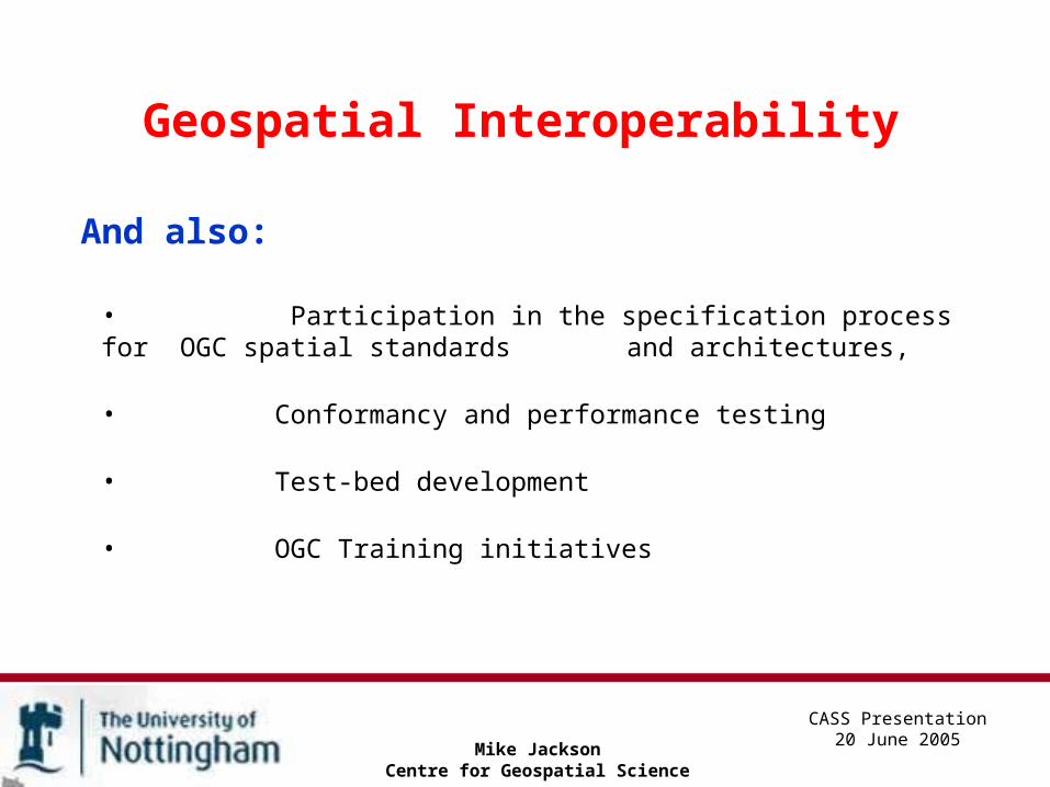
Geospatial Interoperability
Mike JacksonCentre for Geospatial Science
And also:
• Participation in the specification process for OGC spatial standards and architectures,
• Conformancy and performance testing
• Test-bed development
• OGC Training initiatives
CASS Presentation20 June 2005

The University of NottinghamCentre for Geospatial Science
Mike JacksonCentre for Geospatial Science
CASS Presentation20 June 2005
Research Associate/Fellow: Geospatial Interoperability Architects
(1) a lead architect and implementer for the Centre’s standards-compliant geospatial development platform. (2) OGC standards architect for industry based KTP project.• Good 1st degree, pref. a PhD for (1) • Strong background in software design/development within a web-based, SOA environment. • Working experience with OGC and related standards is required.
Will involve participation in OGC test-beds and the standards specification process. Post will include systems development and support for the Centre’s overall research programme + original research in the area of geospatial interoperability. Salary: £19,460 - £29,128
The University of NottinghamCentre for Geospatial Science
Mike JacksonCentre for Geospatial Science
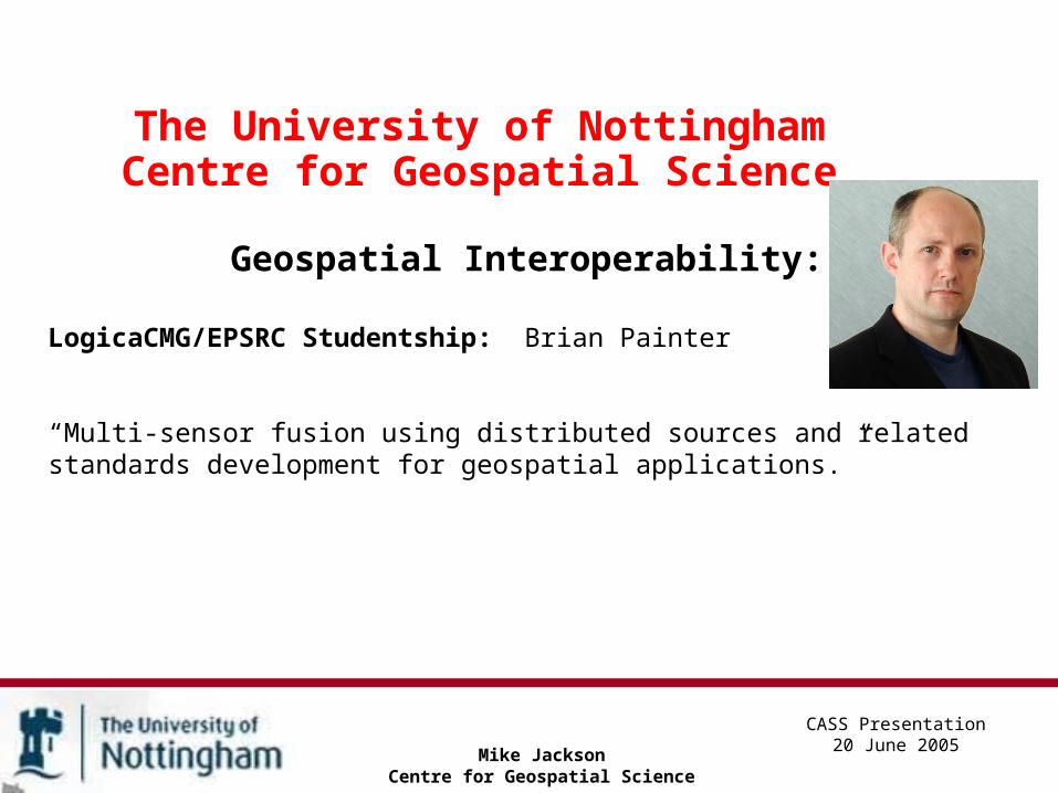
CASS Presentation20 June 2005
Geospatial Interoperability:
LogicaCMG/EPSRC Studentship: Brian Painter
“Multi-sensor fusion using distributed sources and related standards development for geospatial applications.”

Geospatial Intelligence
Mike JacksonCentre for Geospatial Science
Research themes from:
• Data conflation,
• Data association and mining,
• Automatic metadata population,
• Sensor-web enablement,
• Business and homeland security applications.
CASS Presentation20 June 2005

The University of NottinghamCentre for Geospatial Science
Mike JacksonCentre for Geospatial Science
CASS Presentation20 June 2005
Geospatial Intelligence:
QinetiQ Studentship: Jenny Scapens
“The derivation of geospatial intelligence through manipulation, modelling and analysis of conflated multi-source data”

The University of NottinghamCentre for Geospatial Science
Mike JacksonCentre for Geospatial Science
CASS Presentation20 June 2005
Geospatial Intelligence:
Intergraph Studentship: Vÿra Karasová
“Predictive analysis techniques in disaster management and damage mitigation based on discovering spatial association rules over inter-operating databases”.

Mobile Location Based Services
Mike JacksonCentre for Geospatial Science
Research themes from:
• spatial database design and performance,
• self-optimising data models,
• the human sciences aspects of making complex spatial
queries on constrained mobile devices,
• spatial cognition and portrayal,
• new and mass market applications.
CASS Presentation20 June 2005

Mobile Location Based Services
Mike JacksonCentre for Geospatial Science
Suchith Anand
Will work on generalisation and abstraction (schematisation) of maps for mobile device communications. Suchith has an MSc in GIS from City University (2002) and is currently submitting for his PhD (Automatic Derivation of Location Based Services Maps from Large Scale Digital Data) at the School of Computing, University of Glamorgan.
CASS Presentation20 June 2005

The University of NottinghamCentre for Geospatial Science
Mike JacksonCentre for Geospatial Science
CASS Presentation20 June 2005
Mobile Location-Based Services
EPSRC DTA Studentship. Jim Nixon.
~ human factors issues surrounding the perception and communication of different geospatial representations over mobile communications.
Telematics
Mike JacksonCentre for Geospatial Science
Research themes to include:
• Precision location of indoor and outdoor mobile devices,
• Vehicle and pedestrian navigation and tracking,
• Derivation of thematic and CRM content from mobile devices,
• Data-related issues in high-precision spatial applications.
CASS Presentation20 June 2005

Telematics
Mike JacksonCentre for Geospatial Science
CASS Presentation20 June 2005
Dr Jinsoo You: Post-doctoral Research Fellow in Telematics.
Dr You has a BSc in Urban Engineering from Hanyang University, Seoul, Korea (1991), a Masters in Urban Planning from the University of Illinois at Urbana-Champaign (1996) and a PhD also from UIUC in 2000 (received Departmental Outstanding PhD Award).
Experience - in the software industry, as an Adjunct Professor (Geoinformation Engineering) at Sejong University and 2000 - 2004 he was CTO for InComKorea Co Ltd. Also Korean national committee for ISO/TC 211 and an active Member of the Open Geospatial Consortium since 2001.

Mike Jackson
Centre for Geospatial Science
CASS Presentation20 June 2005
Diary Date: 21st November 2005
Inaugural Seminar and launch of Centre at the RICS, London.
A one-day seminar is to be held on the theme of "Disaster Management and Mitigation - the role of geospatial interoperability".
The seminar will have leading industry and academic speakers from the USA, UK and mainland Europe and will be followed by a drinks reception.
Cost £120 (including drinks reception).


![National Institute of Science & Technology Architecture of Message Oriented Middleware Anindya Kumar Jena [1] Architecture of Message Oriented Middleware.](https://static.fdocuments.in/doc/165x107/56649ed55503460f94be62a5/national-institute-of-science-technology-architecture-of-message-oriented.jpg)