
WMO/TD-No.1449-2008 - Typhoon Committee
154
UNITED NATIONS Economic and Social Commission for Asia and the Pacific Report on UN ESCAP / WMO Typhoon Committee Members Disaster Management System January 2009
Transcript of WMO/TD-No.1449-2008 - Typhoon Committee

UNITED NATIONSEconomic and Social
Commission for Asia andthe Pacific
Report on UN ESCAP/WMOTyphoon Committee MembersDisaster Management System
January 2009

Report on UN ESCAP/WMO Typhoon Committee Members
Disaster Management System
By National Institute for Disaster Prevention (NIDP)January 2009, 154 pagesAuthor : Dr. Waonho Yi
Dr. Tae Sung Cheong Mr. Kyeonghyeok JinMs. Genevieve C. Miller
Disaster Management ˆ ` 2009.1.29 4:39 PM ˘ ` 1 ¿ ‚fiˆ •´ lp125 1200DPI 133LPI

WMO/TD-No. 1476World Meteorological Organization, 2009
ISBN 978-89-90564-89-4 93530
The right of publication in print, electronic and any other form and in any language is reserved by WMO. Short extracts from WMOpublications may be reproduced without authorization, provided that the complete source is clearly indicated. Editorial correspon-dence and requests to publish, reproduce or translate this publication in part or in whole should be addressed to:
Chairperson, Publications BoardWorld Meteorological Organization (WMO)7 bis, avenue de la Paix Tel.: +41 (0) 22 730 84 03P.O. Box No. 2300 Fax: +41 (0) 22 730 80 40CH-1211 Geneva 2, Switzerland E-mail: [email protected]
NOTEThe designations employed in WMO publications and the presentation of material in this publication do not imply the expression ofany opinion whatsoever on the part of the Secretariat of WMO concerning the legal status of any country, territory, city or area, orof its authorities, or concerning the delimitation of its frontiers or boundaries. Opinions expressed in WMO publications are those ofthe authors and do not necessarily reflect those of WMO.
Disaster Management ˆ ` 2009.1.29 4:39 PM ˘ ` 2 ¿ ‚fiˆ •´ lp125 1200DPI 133LPI

Contents
3
Foreword 5
Introduction 6
Disaster Management System 8
1. HAZARD FACED 8
2. POLICY LEVELS 11
3. LEGAL FRAMEWORK 11
4. MITIGATION/PREVENTION 11
5. PREPAREDNESS 11
6. RESPONSE 12
7. RECOVERY/REHABILITATION 12
Abstract of Disaster Management System 13
1. DISASTER MANAGEMENT SYSTEM OF CHINA 13
2. DISASTER MANAGEMENT SYSTEM OF HONG KONG, CHINA 14
3. DISASTER MANAGEMENT SYSTEM OF JAPAN 14
4. DISASTER MANAGEMENT SYSTEM OF LAO PEOPLE’S DEMOCRATIC REPUBLIC 15
5. DISASTER MANAGEMENT SYSTEM OF MACAO, CHINA 16
6. DISASTER MANAGEMENT SYSTEM OF MALAYSIA 16
7. DISASTER MANAGEMENT SYSTEM OF PHILIPPINES 17
8. DISASTER MANAGEMENT SYSTEM OF REPUBLIC OF KOREA 17
9. DISASTER MANAGEMENT SYSTEM OF SINGAPORE 18
10. DISASTER MANAGEMENT SYSTEM OF THAILAND 18
11. DISASTER MANAGEMENT SYSTEM OF USA 19
12. DISASTER MANAGEMENT SYSTEM OF VIET NAM 19
Suggestions 21
1. IMPORTANT OF DISASTER RELATED INFORMATION 21
2. COMPONENTS OF A NATIONAL DISASTER MANAGEMENT INFORMATION SYSTEM 22
Conclusions 23
References 24
Appendix 25
Disaster Management ˆ ` 2009.1.29 4:39 PM ˘ ` 3 ¿ ‚fiˆ •´ lp125 1200DPI 133LPI

Disaster Management ˆ ` 2009.1.29 4:39 PM ˘ ` 4 ¿ ‚fiˆ •´ lp125 1200DPI 133LPI

All over the world, in recent decades, have been suf-
fering from natural disasters such as tropical
cyclone, typhoon, hurricane that killed thousands of
people and people throughout the world have
become increasingly alarmed over extreme weather
events owing to climate changes, which seem to be
growing in frequency and adverse impact.
Disaster policy response to climate change is depen-
dent on a number of factors, such as readiness to
accept the reality of climate change, institutions and
capacity, as well as willingness to embed climate
change risk assessment and management in devel-
opment strategies. A focus that neglects to enhance
capacity-building and resilience as a prerequisite for
managing climate change risks will, in all likelihood,
do little to reduce vulnerability to those risks. Reduc-
ing vulnerability is a key aspect of reducing climate
change risk. To do so requires a new approach to
climate change risk and a change in institutional
structures and relationships
Development of disaster management system cop-
ing with climate change is of particular importance
to the United Nations, ESCAP/WMO Typhoon Com-
mittee (TC), which has been making a project on
flood management system and technology to miti-
gate the damage from typhoons in countries of
Asia-Pacific region. And World Meteorological Orga-
nization (WMO) has launched the Natural Disaster
Prevention and Mitigation Programme (DPM) to
enhance its contribution to natural disaster risk
reduction. This programme provides an integrated
and coordinated framework by which governmental
authorities and the natural disaster risk manage-
ment community in both the public and private sec-
tors have access to critical scientific and technical
information, promptly and effectively.
Disaster management system in Typhoon Commit-
tee Disaster Information System (TCDIS) against
typhoons will be upgrade for disaster management
system coping to rapidly changing of climate of the
earth and the social framework. This publication
describes the disaster management system of TC
Member and the guideline and base framework for
the DMS will be a base to upgrade disaster manage-
ment to reduce the typhoon related damages and
disaster preparedness. And it can be used to devel-
op a more comprehensive and effective approach
towards typhoon disaster management of TC Mem-
bers. Under this new initiative, TC will systematize
the TCDIS to share disaster management system of
TC Members, typhoon-related information for miti-
gating damages from typhoons in Asia-Pacific
region.
Foreword
5
Fong Soi KunChairman, Typhoon Committee
Disaster Management ˆ ` 2009.1.29 4:40 PM ˘ ` 5 ¿ ‚fiˆ •´ lp125 1200DPI 133LPI

Typhoons are well known as no geographical
boundaries and bring havoc to very large areas.
Effective response to typhoon including tropical
cyclones calls for regional cooperation among the
affected countries. A key element in such a response
is an efficient typhoon warning system which
involves the rapid and frequent exchange of infor-
mation between countries and areas based on
extensive observations and close monitoring of the
typhoon’s development and movement. Obviously
such activities cannot be effectively performed on
an ad hoc or informal basis, a regional collaboration
mechanism is necessary. The Typhoon Committee
(TC) was organized under the joint auspices of the
Economic and Social Commission for Asia and the
Pacific (ESCAP) and the World Meteorological Orga-
nization (WMO) in 1968 to promote and coordinate
the planning and implementation of measures
required for minimizing the loss of life and damage
caused by typhoons in Asia and the Pacific area
which date and contents of the TC meeting were
described.
The TC has established the Working Group on Dis-
aster Prevention and Preparedness (WGDPP) at the
38th Session held on November 2005, in Hanoi, Viet
Nam. Dr. Sam-Kew Roh, Republic of Korea and Dr.
Ming-Chung Wong, Hong Kong, China were
appointed as first Chair and Vice-Chair of WGDPP
respectively by members of WGDPP and now chair-
man were changed by Dr. Waon-Ho Yi, Republic of
Korea. The WGDPP developed a WEB-GIS Based
Typhoon Committee Disaster Information System
(TCDIS) to shear disaster related information and
reduce damages from typhoon related disasters of
14 TC Members in Asia and Pacific area namely
Cambodia; China; Hong Kong, China; Japan; Lao
People’s Democratic Republic; Macao, China;
Malaysia; People’s Democratic Republic of Korea;
Philippine; Republic of Korea; Thailand; USA; Viet
Nam.
The Disaster Management Systems (DMSs) of 12
TC Members were collected and analyzed to make
the guidelines to consider all elements of effective
disaster management system such as the assess-
ment of risk, the technical disaster management, the
communication needs, and the preparedness of
those at risk. Those elements not directly dealt with
by the project were expected to be in place through
existing means, so that the project would result in a
well integrated system and not be an unconnected
link in the chain. The information was also expected
to have high impact in terms of people affected, to
be technically well-designed, and to be sustainable.
The information was subjected to a quality control
process managed by the WEB-GIS based TCDIS
platform for the promotion of DMS. The first step
was an editing process to ensure that information
met the basic requirements of relevance and com-
pleteness. Altogether 12 information for each sys-
tem was entered into the WEB-GIS based TCDIS.
The second step involved the review and assess-
ment of the information against the guidelines
developed by expert reviewers. Also, needs and
gaps of participating members in relation to the
implementation of the DMS were identified by
analysis information collected from each TC Mem-
bers. The summary of 12 DMS all information col-
lected from 12 TC Members are uploaded in the
WEB-GIS based TCDIS to shear information and
reduce the gap of participating members.
The objectives of the report are following as: (i) to
collect and report of disaster management systems
(DMSs) of 12 TC Members; (ii) analysis the disaster
management systems of each TC Members to make
Introduction
6
Disaster Management ˆ ` 2009.1.29 4:40 PM ˘ ` 6 ¿ ‚fiˆ •´ lp125 1200DPI 133LPI

guideline and support disaster management related
information to reduce the typhoon related disasters;
(iii) to analyze and assess the recent major damages
from typhoon related disasters which information
were collected from each TC Members and were
described in the disaster management system. The
disaster management system are collected from 12
TC Members and reported. The suggestions for the
disaster managements were also reported to define
the needs and gaps of participating members by
developed guideline. The GIS and damages infor-
mation database for the disaster management sys-
tems are implemented in the TCDIS to find similar
typhoon trajectory and to estimate typhoon related
damage and shear the disaster management sys-
tem to reduce damages and for the disaster preven-
tion and preparedness.
7
Disaster Management ˆ ` 2009.1.29 4:40 PM ˘ ` 7 ¿ ‚fiˆ •´ lp125 1200DPI 133LPI
Cambodia ChinaDemocratic Peoples
Hong Kong, China JapanLao People's Democratic
Macau, China Malaysia Philippines Republic of KoreaSingapore
Thailand USA Viet NamRepublic of Korea Republic city-stateGeography
Hazards / Threats
Plan nameLegal Frameworkof DMS
1-National
2-Regional
3-Local
Prevention / Mitigation
Preparedness
-Public Educationand Awareness
Response
Recovery / Rehabilitation
Resources
Budget
Policy Levels
Area: 181,040 sq. km. (69,900 sq.mi.); Terrain: Central plain drained bythe Tonle Sap (Great Lake) andMekong and Bassac Rivers. Forestsaway from the rivers and the lake,mountains in the southwest (Car-damom Mountains) and north (Dan-grek Mountains) along the borderwith Thailand. Climate: Tropicalmonsoon with rainy season June-Oct. and dry season Nov.-May.
N/A floods, droughrts, earthquakes, forest fires, snow, typhoons,and marine disasters. Flooding is the most serious.
Law on Water and Soil Conservation, Law on Earthquake Pre-vention and Disaster Reduction, Law on Fire-Fighting, Meteo-rological Law, Law on Production Safety, Regulation on forestFire-Fighting, Regulation on Preventing Forest Pests, and Reg-ulation on Safety Management of Dangerous Chemicals
China National Committee for Disaster Reduction (NCDR),
Relevant departments under the State Council have basicallycompleted their emergency-response plans. 31 provinces and2,347 counties have also released their plans. As a result, anational emergency-response plan management system fornatural disasters has already taken shape.
Public awareness by timely reporting of disasters and relevantdisaster reduction activities, holding specialized lectures,columns and programs on TV, radio as well as newspapers.Various charity shows for disaster reduction and poverty relief,disaster-reduction summer camping activities for middleschool students and national quiz shows on disaster reductionwere carried out throughout the country.
A national emergency-response plan system for natural disas-ter management has been set up. In order to improve variouspre-warning and emergency-response mechanisms and gov-ernments' capabilities to handle emergencies and risks, theChinese Government has promulgated the national NaturalDisaster Emergency-Response Plan.
Since 1998 China began to set up a central-level materialreserve system for disaster relief. Central-level material reservepoints for disaster relief have been built in Shenyang, Harbin,Tianjin, Zhengzhou, Hefei, Wuhan, Changsha, Nanning,Chengdu and Xian. Provincial-level material reserve warehous-es for disaster relief have been set up in almost all of provinces,autonomous regions and municipalities.
CDIS, NIDP, EHP, NAAT, grants, etc
$300 million dollarsNatl - 4.5 trillion yen
Recovery phase: return the communi-ty to a condition considered accept-able by the community. Restorationphase; restore the community to thestate prior to the disaster.
Community assistance programs - public assistancegrant program, hazard mitigation grant program.
Continued capacity building. Gov-ernment forges MOAs with variousNOGs covering response, relief andrehabilitation aspects of disastermanagement such as CALAMIDAT.PH and Program for Hydro-Meteoro-logical Risk Mitigation in Secondarycities in Asia PROMISE project withCenter for Disaster PreparednessFoundation, Inc
Community assistance programs activated by a dis-aster delcaration include the public assistance grantprogram, hazard mitigation grant porgram, firemanagement assistance grant program, and theNEMA grant and assistance program.
Disaster Prevention and Mitigation Academy(DPMA) to be the principal academy in the fieldof disaster prevention and mitigation for equip-ping the personnel in charge of disaster man-agement with technical know-how and practicalskills which will be beneficial to national disastermanagement
Recovery includes short-term and long-term activities. Short-term recoveryseeks to restore critical basic life support systems such as power, water, com-munications, transportation and medical. Long-term recovery focuses onrestoring the affected community to its normal or improved state of affairs priorto the emergency/disaster. The recovery period is an opportune time to estab-lish and implement mitigation measures, particularly those related to the recentemergency/disaster.
"CBDRM" approach has been employed at different levels and indistinctive areas in Vietnam. Deeper research clearly showedthat there are common factors between meaning, objective ofCBDRM and meaning, objectives, policies and fundamental prin-ciples of Vietnamese Government. That is "relying on the peopleand mainly implemented by the people", fostering grassrootdemocracy through implementation of "grassroots democracyregulation", principles of "Publicize and socialize flood storm con-trol and disaster mitigation" and "4 on-site motto", "sharingresources and collaborative implementation" such as co-fundingby Central government and locality in construction of disastermanagement infrastructures, laid out legal basis for local institu-tions "participate in monitoring the construction of disaster man-agement works", encourage the adoption of "measures andnew-technology solutions".In this view, there has been both"top-down" and "bottom-up" approaches but at different levels.Some cases are still keen on top-down approach as a result ofthe centralized planning mechanism in the past years that notonly partly obstacle but also need the more time for fully apply-ing the CBDRM approach in some case. However, those princi-ples and mottos have strengthened the responsibility of relevantstakeholders. On the other hand, those have mobilized tradition-al experience, resources and partly ensure the sustainability andeffectiveness of disaster management activities.
recovery/rehab countermeasures, etc In accordance with the Civil Protection Framework,all hygiene departments and agencies in MSARhave been including in the framework to ensuremedical services in case of the occurrence of anymajor emergency and disaster. Community Assis-tance grant program - government departments orprivate agencies will provide certain funding sup-ports or accommodation and any other necessaryhelp to victim of disaster in according to each case.In addition, certain large infrastructure programs,community reconstruction programs, other con-struction works related to the slope safety, coastprotection and sanitation network development forbetter flood mitigation, and so on, are being execut-ed by relevant government departments or havebeen included in Macao's development plan.
Rescue phase objective: rescue of life,protection of property and contain-ment of the situation/incident or pre-vent any further deterioration.
Disaster emergency response, wide-areasupport system
Prime Minister set up the ad hoc committee for floodfighting which is presided by Agriculture & ForestryMinister. Role and function of the ad hoc committee isto collaborate with the National Disaster ManagementCommittee for flood prevention and fighting. Responseactivities may include sand bag suplies, resource mobi-lization, distribution of relief packages, and more.
Coordination office-GCSeg.- mainly dealswith the civil protection, including handlingall kinds of disasters, and functions as acoordinator to communicate with all partiesin regard to the concerned field and collabo-rate with them, to estimate and prepare allnecessary resources required for disasterrelief and emergency, to encourage them toestablish any necessary measure /mecha-nism and activities for reducing disastersand their impacts, and so on. Includes med-ical system for disaster and SAR.
Whenever a severe disaster occurs, meeting at district, state ornational levels, will be immediately convened by the DisasterManagement and Relief Committee. A Disaster Control andOperation Centre will also be operationalized. The operation ofthe Disaster Control and Operation Centre will be establishedbased on the disasters which could either be at the District,State or National level. Includes search and rescue operations,needs assessment for provision of medical care and preventingthe spread of disease; providing basic needs for procuring anddistributing food, shelter and clothing; ensure fair distribution ofresources; providing livelihood and economy for assisting peo-ple to earn a living to help them recover; emotional support forcounselling and reuniting separated families; logistics for trans-portation of people and equipment; finance for obtaining, allo-cating and accounting for money; communication for mediacoverage, information for families, fundraising; and infrastruc-ture for rebuilding damaged infrastructures
Government and private sectorswork together to provide immediatedispatch of essential medicines todisaster victims, medical response todisater-related injuries. Governmenttakes a cluster approach at theprovincial level, elevate LGUs Searchand Rescue capability, upgrade thecapability of Disaster/EmergencyOperation Centers and develop stan-dards to evaluate the operationalreadiness of critical facilities.
National Response plan gives the basics for howthe government coordinates with local and tribalgovernments and the private sector during inci-dents. Other response include mobile emergencyresponse support, national disaster medical system,and urban search and rescue.
One Tambon One Search and Rescue Team(OTOS)
During a response phase, emergency services during a crisis are provided.These activities help to reduce the loss of life, injuries, damage to the islandresources and expedite recovery efforts. Response activities include, but notlimited to; warning and evacuation, search and rescue and other functionaloperations addressed.
Create favourable conditions for people to participate in the devel-opment of legal documents, planning, management and monitor-ing the implementation of programmes and projects in local areas.(ii) Foster dissemination activities and community awareness ris-ing. Building capacity for self disaster preparedness, promote thetradition of mutual support in emergency relief operations; Estab-lishment of community voluntary groups to participate in searchand rescue operation. Promoting the role of social organizations inpreparedness, response and recovery; Develop the volunteer net-work to assist in dissemination, mobilization, recovery and rehabili-tation of production. Encouraging organizations, individuals insideand outside the country to contribute diverse and effective supportfor people and localities affected by natural disasters; (iii) Reinforc-ing training of human resources to meet the requirement of disas-ter prevention, response and mitigation, especially for disastermanagement, advisory and coordination offices.
Public information campaign on disasterpreparedness through promotion of an inte-grated and coherent strategic public infor-mation campaign on disaster preparednessthrough the conduct of nationawide tsunamiand earthquake drills; distribution of postersand flyers on naturla hazards; and other IECthrough the tri-media. Also the developmentof the web-based Calamidat.ph.
Ministry of Home Affairs constantly engages the peoplethrough a series of public education programmes toenhance public awareness in emergency preparedness.The Ministry of Home Affairs has established the Com-munity Safety and Security Programme (CSSP), aframework that encourages the community to look afterits own safety and security through self-help and mutualsupport. It also serves to foster community cohesionand harmony among local grassroots leaders, residents,students and workers. "My Ready Mobile"
risk reduction, flood insurance, value to society andbest practices
Mr. Disaster Warning
Testing of plans with annual drills 1. National land conservation; observationsystems; info/comms;integrated DM
Achieved by organizing, coordinating, tak-ing part actively in activities related to thecivil protection, and cooperating well withrelevant departments and agencies of eitherpublic or private sector. Includes training.
COOP, DM exercises, training COOP, Natl Preparedness guidelines, training, dis-aster prevention plan
X Preparedness activities serve to develop and enhance capabilities needed in theevent of an emergency/disaster. Planning, exercising, training, and developingpublic information programs and warning systems are among the activitiesconducted at this phase.
Disasters include flood, drought, landslides, as well as unex-ploded ordinance, fires and other man-made hazards. Firesand traffic accidents cause the greatest loss of life and prop-erty.Lao PDR Urban Disaster Mitigation Project (LUDMP)focuses on these two major hazards & generally aims atincorporating risk management and hazard mitigation intothe development planning of urban areas in Lao PDR, withthe city of Vientiane as the pilot demonstration site.
Disaster Reduction Plan has the following guiding principles as: (i) dis-aster reduction should be deeply considered in national economic andsocial development; (ii) prevention should be taken as the priority incombination with resistance and relief; (iii) the role of science, technol-ogy, and education should be incorporated in disaster reduction; (vi)the central and local governments as well as all social sectors shouldbe to reduce disasters; and (v) International exchange and cooperationshould be strengthened. Community-based Disaster Reduction Out-reach Campaign. A National Disaster Reduction Center of China(NDRCC) serves as a center for disaster information sharing, technicalservices and emergency relief decision consultancy. Its main functionsare to assess and analyze the occurrence and development of majordisasters, and provide services on forecast, assessment and support-ing disaster reduction decisions and information; to collect and ana-lyze disaster reduction information both at home and abroad for infor-mation sharing; to provide technical assistance and supporting deci-sions for major emergency relief work; to organize international disas-ter reduction exchanges and cooperation.
Security Bureau
Emergency Monitoring and SupportCentre
Numerous government agencies
HKO monitors wx and initiatesissuance of all warnings of svr wxconds. Info distributed to variousgovt depts and to media. Departmen-tal training programs, capacity build-ing. Success of plan depends ondept officers thoroughly trained ontheir roles in dealing with emergecysituations arising fm natural disasters.
Reports submitted by relevant departmentsto GCSeg which are then analyzed andmonitored for firm implementation of plans.Implement firmly and effectively the func-tions and responsibilities of GCSeg.
Structural Designs for flood mitigation, Enhanced pub-lic education and awareness,addition of an early warn-ing system
4-Point Plan of Action Risk analysis through flood hazard mapping, nation-al dam safety pgm, natl hurricane pgm, mitigationplanning
Capacity building by offering internationalcourses conducted at the Civil Defence Acade-my (CDA). The courses offered include, theInternational Urban Search and Rescue Course,International Fire Fighting Course, InternationalHazMat Course, International Disaster Manage-ment Course and International Fire InvestigationCourse. Besides, overseas participants have alsoattended the SCDF Basic Officers Course, andthe Emergency Response Specialists Course,together with our local trainees.
Conducts the exercise regularly at least twotimes per year in every provinces and districts toensure all agencies are familiar with their rolesand functions parallel with developing the emer-gency response teams capabilities. In theregional level, Thailand has sent her responseteam to participate in ASEAN Regional DisasterEmergency Simulation Exercise which has codename "ARDEX" every year; particularly in thisyear (2008) ARDEX 08 is hosted by Thailand.
Mitigation activities are those that eliminate or reduce the damaging effectscaused by an emergency/disaster occurrence. Included are those long-termactivities that lessen the undesirable effects of unavoidable hazards such asestablishment and enforcement of building codes, flood plain management,insurance, elevating buildings and public education programs. Hazard Mitiga-tion Plans have been prepared to comply with the Stafford Act and DisasterMitigation Act of 2000 (DMS 2000). The overall purpose of the plan is to estab-lish a comprehensive hazard mitigation program to reduce the loss of life andproperty, human suffering, economic disruption, and disaster assistance costsresulting from natural and human-caused disasters, at island and village levels.
Flood and storm preparedness and mitigation process,flash flood mitigation in mountainous and midland areas,inundation preparedness and mitigation since inundationoccurs annual on large scale, drought, saltwater intrusion,desertificaiton, whirlwinds and hail rain, storm surge, for-est fires, landslides, reservoir, industrial production,
National Action Plan on DM establishes the District DisasterManagement Committee in all districts; makes identification ofthe focal point in all sectors; develops and establishes earlywarning and information system in all of 142 districts in coun-try; sets up information network in disaster prone villages; con-structs warehouses for storing the emergency assistancematerials in all provinces and some disaster prone districts;attends continue public awareness activities with media; wide-ly organizes training on DM for all sectors and levels; organizessimulation exercise with the involvement of rescue team unitin sectors and community; and to raise capacity up on cooper-ation with other countries in the framework of Asian, Regionaland United Nations to exchange information and experienceson DM. establishing systems for hazard assessment and disas-ter mitigation to ensure fire and road safety for the city of Vien-tiane, and other major cities and communities.
3 plans: Basic Disaster Management Plan(CDMC), Disaster Mangement Operation Plan(govt orgs and designated public corporations,and Local Disaster Management Plan (prefec-tural and municipal disaster mgmt council)
Civil Defense Divisions In the provincial level, the Governor as the ProvincialDirector will be responsible for operating disaster preven-tion and mitigation of the province. As well as the district,the District Chief Officer as the District Director will carryout the disaster prevention and mitigation in the district.
Village leaders/mayors
Central Disaster Management Council =based on Disaster Countermeasures BasicAct and promotes comprehensive disastercountermeasures including deliberatingimportant issues on disaster reduction.
Natl Disaster Mgmt Committee-promotes disasterreduction ACTIVITIES OF EXISTING liNE Ministries andProvinces on natural DM and protection
Security Forces Coordination Office (GCSeg.),which is subordinate to the Secretary for Securitywith the authorities empowered by the ChiefExecutive of MSAR, is a special office mainly tak-ing responsibility of the civil protection affairs,particularly in combating against natural disastersas well as man-made disasters or incidences.
A Disaster Control and Operation Centre will also beoperated. The operation of the Disaster Control andOperation Centre will be established based on the dis-asters which could either be at the District, State orNational level.
OCD as operating arm and the secre-tariat of the NDCC
Several divisions fall under NEMA with specificfunctions
Singapore Civil Defense Force DDPM Director General as Central Director willcontrol and supervise the operation of theProvincial Director or other directors in localadministrations and civil defence volunteer allover the country.
State Emergency Management Offices (FSM) The CCFSC has component such as (i) chairman as the min-ister of Ministry of Agriculture and Rural Development(MARD), (ii) Standing Deputy Chairman by the Deputy Min-ister of MARD, (iii) Deputy Chairmen by Deputy Director ofGovernment's Office and Deputy Chief of the General Staffof Vietnamese People's Army, and (iv) Members of CCFSCby the Deputy Ministers of Ministries and Sectors
Cabinet Office - Minister of State for DisasterManagement = integrate and coordinatedisaster reduction policies and measures ofministries and agencies.
Within the Ministry of Labour and Social Welfare, theNational Disaster Mgmt Office has responsibility for theformulation of the govt policy on DM
Chief Executive of MSAR National Security Council is tasked to coordinateefforts among the various agencies involved in disas-ter management.
National Disaster Coordinating Coun-cil (NDCC)
18 Ministries, 4 Central Offices, and 18 Agencies andeach body has different roles in disaster management.The National Emergency Management Agency (NEMA)has an overall coordinating function in the national level.
Ministry of Home Affairs National Disaster Prevention and MitigationCommittee (NDPMC) is the main policy makingbody
Homeland Security (Guam) or National Emergency Management Offices CCFSC and the Committees for Flood and Storm Control(CFSC) of all levels and sectors.
Heavy rain, storm surges, thunder-storms and tropical cyclones
Contingency Plan for Natural Disasters National Action Plan on DM from 2001 to 2010
Did not list specifics but can assume earth-quakes, tropical cyclones, floods, landslides
Disaster Countermeasure Basic Act 1961 Landmark decree No, 158 (Aug 1999) est NDMC Decree-Law no. 72/92/M, 28 Sept 1992, LawNo. 9/2002 (Internal Security Legal Frame-work) for ensuring social order and stability;Executive Order No, 16/2000, some basicconcepts relating to typhoons; Dispatch no.87/2000 , some measure applicable to theeducation institues during typhoon signal orrainstorm; Executive Dispatch No. 166/2002,directives for all public depts to follow whentyphoon sitnal #8 or above.
Directive No. 20 of NSC NDCC legal authority is PresidentialDecree (PD) 1566 on 6/11/1978; Officeof Civil Defense created by Letter ofInstruction 19 (1972)
Disaster Prevention and Mitigation Act 2007 -main law to manage disasters, including airthreat and sabotage.
Stafford Act and Disaster Mitigation Act of 2000 Decree No. 168-HDBT (1990) stipulates funcvions andduties of the Central Committee for Flood and Storm Con-trol at all levels and sectors.
Natural Disaster Countermeasures Act, (1995) prescribescontrol of and countermeausres against natural disasterssuch as torrential rain and typhoons, investigations of rele-vant damage, rehabilitation, costs, etc. Act on Countermea-sures against Agricultural and Fishery Disaster (1995) stipu-lates measures concerning prevention of and countermea-sures against disasters affecting agriculture and fishery.Disaster Relief Act (1962) provides for relieve of victims ofnatural disasters or calamities, etc. Disaster and Safety Man-agement Basic Law (2004) designate disaster managementcompetent organizations based on the disaster definition.
Flood, drought, landslides, unexploded ordinance, fires Typhoons, heavy rain, earthquakes, tsunami Although Malaysia is spared from the threats of severenatural disasters and calamities, it nonetheless experi-enced some form of disaster from flooding, man-madedisaster, landslides and occurrences of haze pollutions.
Tropical cyclones, landslides, earth-quakes, volcanic eruptions, floods,heavy rainfall
Floods, torrential rain, typhoons, earthquakes, andman-made disasters
While it is spared from natural disasters such astsunamis, earthquakes, and volcanic eruptions,it is not entirely safe from man-made disasters.Rcent disasters included Pulua Merlimau Fire,Nicoll cave-in and a 6-storey Hotel New Worldcollapse.
Tropical cyclones, drought, landslides, storm surges, coastal inundation tropical cyclones, floods, storms, drought, salt-waterintrusion, whirlwinds and hail, storm surge, landslides,forest fires
North is mountainous area which is prone to flashflood, landslide/ mudslide and earthquake. TheNortheast is arid area and always faces on severedrought and flood. The Central region is the Basinof Chao Praya River and become flood during therainy season. The South is hilly to mountainouswith several offshore islands and encountersflood, tropical storm, landslide and forest fires.
Area: 9,596,960 sq. km. (about 3.7 million sq. mi.). Terrain:Plains, deltas, and hills in east; mountains, high plateaus,deserts in west.Climate: Tropical in south to subarctic in north.
Area: 120,540 sq km; Ter-rain: mostly hills andmountains separated bydeep, narrow valleys;coastal plains wide in west,discontinuous in east. Cli-mate: temperate with rain-fall concentrated in sum-mer
Area: 377, 835 sq. km. (145,902 sq. mi.). Ter-rain: Rugged, mountainous islands.Climate: Varies from subtropical to temper-ate.
Area: 1,104.3 sq. km.; Terrain: Hilly tomountainous, with steep slopes andnatural harbor. Climate: Tropicalmonsoon. Cool and humid in winter,hot and rainy from spring throughsummer, warm and sunny in fall.
Centre of southeast Asia bordering China (416 km tothe North), Myanmar (230 km to the North West),Thailand (1.7 km to the West), Cambodia (492 km tothe South) and Vietnam (1.9 km to the East).
Area: 25.4 sq km, located in Eastern Asia,bordering the South China Sea and China;Terrain: generally flat; Climate: subtropical;marine with cool winters, warm summers
Area: 329,748 sq. km. (127,315 sq. mi.); Terrain: Coastalplains and interior, jungle-covered mountains. TheSouth China Sea separates peninsular Malaysia fromEast Malaysia on Borneo. Climate: Tropical.
The Philippine Archipelago occupiesthe western rim of the Pacific Ocean(Western Segment of the PacificRing of Fire), a most active part of theearth that is characterized by anocean-encircling belt of active volca-noes and earthquake generators(faults).
Located in the Far East facing the Chinese continenton its west and the Japanese archipelago on itseast. About 70% of the total land area (220,848km2) is mountainous area. Temperate climate withfour distinct seasons characterized by many ariddays in spring, substantial rain in summer andmuch snow in winter. Typhoons occur mostly fromJuly to September with two or three affecting Koreadirectly or indirectly.
AreaL 707 sq km. Cities: Capital--Singapore(country is a city-state). Terrain: Lowland. Cli-mate: Tropical.
Area: 513,119 sq. km. Bordered to the north byLaos and Burma, to the east by Laos and Cam-bodia, to the south by the Gulf of Thailand andMalaysia, and to the west by the Andaman Seaand Burma. By the maritime boundary, the coun-try is bordered to the southeast by Vietnam inthe Gulf of Thailand, to the southwest by Indone-sia and India in the Andaman Sea.
United States-affiliated Islands in the western North Pacific consisting of the Terri-tory of Guam (Area: 549 sq km, Terrain: volcanic origin, surrounded by coralreefs; relatively flat coralline limestone plateau, with steep coastal cliffs and nar-row coastal plains in north, low hills in center, mountains in south), Common-wealth of the Northern Marianas Islands (Area: 477 sq km; Terrain: southernislands are limestone with level terraces and fringing coral reefs; northern islandsare volcanic , the Republic of Palau (Area: 458 sq. km. in eight main islands plusmore than 250 islets. Terrain: Varies from mountainous main island to smaller,reef-rimmed coral islands.), the Federated States of Micronesia (Area: 702 sq. km,Terrain: 607 mountainous islands and low-lying coral atolls.) and the Republic ofthe Marshall Islands (Area: 181 sq. km. of land area scattered over 750,000 sq. mi.of the Western Pacific. Terrain: 29 low-lying coral atolls and five single islands.)
located in the monsoon tropical region, with total main-land area of 329,241 square kilometer and a coastal line of3,260 kilometer in length. On average, there is one kilome-ter of coastal line on every 100 square kilometer.
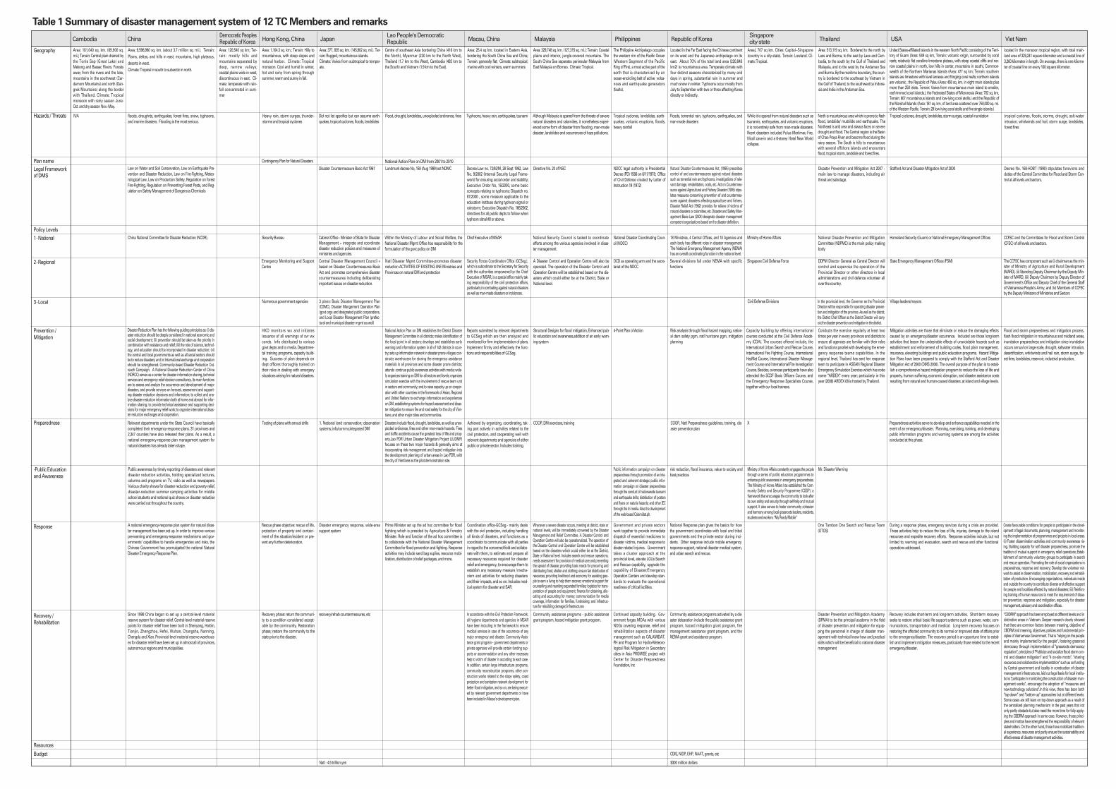
Table 1 Summary of disaster management system of 12 TC Members and remarks

At the 40th session of the UNESCAP/WMO Typhoon
Committee, the Disaster Prevention and Prepared-
ness Working Group Chairperson assigned two
Members of the working group to conduct a com-
parative study of all Members’ Disaster Manage-
ment Systems (DMS) and Early Warning Systems
(EWS) reports.
A Disaster Management System is defined as the
strategic plan of a country that addresses every pos-
sible disaster that can affect that particular country.
While countries vary in size, geography, vulnerabili-
ty to disasters, political entity, economic structure,
and languages, the Disaster Management Systems
of each country share many similarities. This report
addresses the Disaster Managements Systems of
the following TC Members: China, Hong Kong
China, Japan, Laos, Macao China, Malaysia, Philip-
pines, Republic of Korea, Singapore, Thailand, USA,
and Viet Nam. Reports from Cambodia and the
Democratic Peoples Republic of Korea were not
available.
The makeup of the DMS focuses on the ways each
Member responds and relates to natural disasters.
Each report had their specific way of documenting
the actions of their country but the basics were
addressed in all reports although the terminology
would vary from plan to plan. (This report will cate-
gorize each Member’s DMS and uses the Hyogo
Framework for Action (HFA) as a basis of compari-
son. HFA demonstrates the basic fundamentals of
pre-disaster actions (mitigation, planning and pre-
paredness) and the post-disaster actions (response,
recovery and rehabilitation). According to the
International Strategy for Disaster Reduction (ISDR)
web site, the HFA is the key instrument for imple-
menting disaster risk reduction and is adopted by
Member states of the United Nations. Its goal is to
build resilience of nations and communities to dis-
asters (Refer to www.unisdr.org/hfa for further
details). Many countries referred to this in their
plans.)
In the Typhoon Committee Integrated Workshop on
Beijing (2008.9.22-26), WGDPP Members agreed to
develop formatted disaster management system for
each TC Members including following contents
such as: (i) Introduction (Organization and Frame-
work), (ii) Prevention and Preparedness (Mitigation),
(iii) Emergency Response, (iv) Recovery and Reha-
bilitation, (iv) Capacity Building (Training), (v)
Resources (Financial, Information, etc.), (vi) Recent
Major Disasters, (vii) Future Programs & Projects for
only web-site version; (optional).
The disaster management systems of TC Members
were summarized and defined to make guideline of
the typhoon related disaster management system.
The summary of 12 disaster management systems
is described in Table 1. For the summary 12 items
are categorized such as geography, Hazards/threats,
plan name, legal framework of DMS, policy levels,
prevention/mitigation, preparedness, public educa-
tion and awareness, response, recovery/rehabilita-
tion, resources, and budget which items are select-
ed from 12 disaster management system.
Emergency response plans of the DMS addressed
multi-hazard events that affected each TC Members.
The types of hazards faced and the severity of these
hazards generally depended on the geographical
location of each country. Natural hazards men-
tioned in the plans include tropical cyclones,
heavy/torrential rain, flooding, landslides, storm
1. HAZARD FACED
Disaster Management Systems
8
Disaster Management ˆ ` 2009.1.29 4:40 PM ˘ ` 8 ¿ ‚fiˆ •´ lp125 1200DPI 133LPI

surges, forest fires, and droughts. Also noted were
man-made disasters associated with industrial pol-
lution, unexploded ordinances and terrorist attacks.
All reports referred to a hierarchy of agencies that
address natural disasters in the countries. The levels
of management of natural disasters begin at the top
or the national level. At the national level, the role is
to dictate policy and procedure for disaster manage-
ment. The next level, for this report, will be labeled
the “Regional” level and has the mandate to take
that policy and address it to regional centers or loca-
tions that can vary according to geography or logis-
tical reasons. Then there is the more community
based or local level in which the local management
takes the regional mandates and tailors them to the
community and establishes community-based sys-
tems. The response at this localized or community
level is designed to address specific areas or groups
and become more efficient in reaching the rest of
the populace of the country. Not all countries poli-
cies are dictated from the top down. For example,
the country of VietNam takes both “top-down” and
“bottom-up” approaches to disaster planning.
Almost all DMS cited a specific law or decree or act
on Disaster reduction/preparedness. Only Singa-
pore DMS report did not mention a legal frame-
work.
Mitigation/Prevention activities are those that elimi-
nate or reduce the damaging effects caused by an
emergency/disaster occurrence. It is also embedded
in the national economic and social development of
each country. Many methods are in place to miti-
gate disasters. They include early warning systems,
strong and reliable forecasts, sound structural
designs, enforcement of building codes, and mitiga-
tion analysis (such as flood mitigation analysis). For
large cities, a smart urban development plan is key.
Emergency response plans specify ways to deal
with disasters. A large part of the Member reports
highlighted these plans and emphasized consistent
training programs and frequent drills for the
response agencies of their country. Republic of
Korea and Malaysia both have a “Continuity of
Operations Plan (COOP)” to address situations
where the country’s operations must continue
despite setbacks from a disaster. Another prepared-
ness activity that rang common through all plans is
public awareness and education. Whether it be
“grass roots” or a large “media campaigns”, this
appears to be an effective way of reaching the pub-
lic. Countries such as the Philippines, Singapore
and Thailand have a specific public awareness cam-
paigns such as calamidat.ph, My Ready Mobile, and
Mr. Disaster Warning respectively.
5. PREPAREDNESS
4. MITIGATION/PREVENTION
3. LEGAL FRAMEWORK
2. POLICY LEVELS
11
Disaster Management ˆ ` 2009.1.29 4:40 PM ˘ ` 9 ¿ ‚fiˆ •´ lp125 1200DPI 133LPI

A majority of the reports referred to having an
Emergency Response plan in effect during times of
disasters. These response plans give the basics for
how a country coordinates with local governments
and the private sector during incidents and helps
the governments handle emergencies in a more
effective manner. Other response actions include
warnings, evacuations, mobile emergency response
support, national disaster medical system, and
search and rescue. Using non-government organi-
zations to assist with response activities was anoth-
er means to maximize the response in natural disas-
ters.
The recovery and rehabilitation phase is the point
where efforts are focused on restoring the commu-
nity to a condition considered acceptable by the
community (short-term) and a more long term goal
of restoring the community to its normal or
improved state prior to the disaster. Some DMSs
specified the many programs available to assist the
general populace in reaching that pre-disaster state
once again. Community assistance grant programs
and reconstruction programs were favorable and
identified ways to ensure a population is restored to
normalcy and yet equipped with ways to handle the
next emergency. This is where capacity building is
also emphasized in DMS plans.
7. RECOVERY/REHABILITATION6. RESPONSE
12
Disaster Management ˆ ` 2009.1.29 4:40 PM ˘ ` 10 ¿ ‚fiˆ •´ lp125 1200DPI 133LPI

The Disaster Management Systems (DMSs) of 12 TC
Members were collected and analyzed to make the
guidelines. The information was subjected to a quali-
ty control process managed by the WEB-GIS based
TCDIS platform for the promotion of DMS. The first
step was an editing process to ensure that informa-
tion met the basic requirements of relevance and
completeness. The second step involved the review
and assessment of the information against the
guidelines developed by expert reviewer. Also,
needs and gaps of participating members in relation
to the implementation of the DMS were identified by
analysis information collected from each TC Mem-
bers. The abstracts of DMSs collected from 12 TC
Members were reported to shear information and
reduce the gap of participating members.
Country : China
Submitting Organizations :
Department of Water Hazard Research,
China Institute of Water Resources and
Hydropower Research
Primary Contact : DU Xiao He
Tel: +86 10 68781755
Abstract : The principle of disaster management
systems of China is parallel development of econo-
my taken into account in constructing production
and living facilities and natural disaster reduction.
Major priority of disaster management of China is
disaster prevention such as disaster resistance and
relief to support national economic and social devel-
opment. The strategic frameworks for the disaster
management are (i) for the sustainable develop-
ment; (ii) for protecting people’s lives and properties
by comprehensive disaster-reduction activities; (iii)
for the enhanced disaster-reduction awareness of
the general public. Multiple methods and monitor-
ing systems were implemented in the disaster man-
agement system to carry out disaster-reduction and
to display the overall efficiency of various disaster
reductions. To set priorities they are considering key
issues bearing on the overall interests of disaster
reduction in which limited resources are concentrat-
ed on strengthening the development of key pro-
jects and comprehensive work in key regions
focused on natural disasters. The role of science,
technology and education are fully represented in
disaster management system. The process of trans-
forming existing scientific results into actual capabil-
ities of disaster reduction is accelerated for better
abilities to reduce disasters. Disaster-reduction edu-
cation is integrated with popularized and specialized
education oriented towards whole society so as to
uplift the level of disaster-reduction knowledge of
the general public. All positive elements are mobi-
lized. Initiatives of the central and local governments
as well as all social sectors are displayed in the sys-
tem. Under the unitary organization and deploy-
ment of the government, relevant departments
coordinate closely with each other and enterprises
as well as cross-sections of society are broadly
involved for effectively reducing disasters. Adminis-
trative divisions for China’s disaster management
are following as: (i) 23 provinces; (ii) 5 autonomous
regions such as Guangxi, Nei Mongol, Ningxia, Xin-
jiang, and Xizang (Tibet); (iii) 4 municipalities such
as Beijing, Chongqing, Shanghai, Tianjin; and (iv)
special administrative regions such as Hong Kong,
Macao. Multi-channeled and multi-layered interna-
tional exchanges and cooperation is actively carried
out to continuously improve China’s disaster-reduc-
tion undertakings and China’s standing in the
international disaster-reduction community.
1. DISASTER MANAGEMENT SYSTEM OFCHINA
Abstract of the Disaster Management Systems
13
Disaster Management ˆ ` 2009.1.29 4:40 PM ˘ ` 11 ¿ ‚fiˆ •´ lp125 1200DPI 133LPI

Country : Hong Kong, China
Submitting Organizations :
Assistant Director,
Hong Kong Observatory
Primary Contact : Mingchung Wong
Tel: +85 2 29268232
Abstract : Natural disasters that occur in Hong
Kong are generally the result of severe weather con-
ditions such as exceptionally heavy rain, storm
surges, thunderstorms and tropical cyclones. These
events can result in considerable disruption to trans-
port and other essential services and cause floods,
landslips and other incidents giving rise to casual-
ties. Tsunami, which is a geophysical hazard that
poses a threat to coastal communities worldwide,
has a very small chance of affecting Hong Kong sig-
nificantly. The consequences of any natural disaster
and the counter measures required to deal with it
will vary according to the circumstances. The Hong
Kong Observatory (HKO) monitors weather condi-
tions closely and initiates all warnings of severe
weather conditions in Hong Kong. These include
tropical cyclone, rainstorm, landslip and thunder-
storm warnings. Messages will also be issued giv-
ing general advice on precautions to be taken to
minimize the loss of life and damage to property,
followed by supplementary information and advice
as the situation develops. The warnings will be dis-
seminated to relevant responding bureaux/depart-
ments and other related parties according to the
prescribed alerting arrangement in the CPND. In
addition to the CPND, each government bureau
/department has its own detailed operational
instructions to implement the contingency plan. A
contingency plan entitled “Contingency Plan for
Natural Disasters” summarizes the alerting systems
and organisational framework of the Hong Kong
Special Administrative Region Government (here-
after denoted as Government) for responding to
such disasters. Functions and responsibilities of
Government departments and other bodies in the
event of natural disasters including those resulting
from severe weather conditions are also set out in
the Contingency Plan. In addition to the Contin-
gency Plan, each department has its own detailed
operational instructions. The Contingency Plan for
Natural Disasters in Hong Kong is available at
http://www.sb.gov.hk/eng/emergency/index.htm.
Country : Japan
Submitting Organizations :
Deputy Director, International Office for
Disaster Management Cabinet Office,
Gov. of Japan
Primary Contact : Shingo Kochi
Tel: +81 3) 35039394
Abstract : To protect national land as well as citi-
zens’ lives, livelihoods, ands property from natural
disasters is a national priority. The turning point for
strengthening the disaster management system
came after the immense damage caused by the Ise-
wan Typhoon in 1959, and led to the enactment of
the Disaster Countermeasures Basic Act in 1961,
which formulates a comprehensive and strategic
disaster management system. Main contents of the
Disaster Countermeasures Basic Act is (i) definition
of responsibilities for disaster management, (ii) dis-
3. DISASTER MANAGEMENT SYSTEM OFJAPAN
2. DISASTER MANAGEMENT SYSTEM OFHONG KONG, CHINA
14
Disaster Management ˆ ` 2009.1.29 4:40 PM ˘ ` 12 ¿ ‚fiˆ •´ lp125 1200DPI 133LPI

aster management organizations, (iii) disaster man-
agement planning system, (iv) disaster prevention
and preparedness, (v) disaster emergency response,
(vi) disaster recovery and rehabilitation, (vii) finan-
cial measures, and (viii) state of disaster emergency.
The disaster management system has been further
strengthened following the lessons learned from
large-scale disasters such as the Great Hanshin-
Awaji Earthquake. Japan’s disaster management
system addresses all of the disaster phases of pre-
vention, mitigation and preparedness, emergency
response as well as recovery and rehabilitation.
With clear roles and responsibilities of the national
and local governments, the relevant stakeholders of
the public and private sectors cooperate in imple-
menting various disaster countermeasures.
Country : Lao People’s Democratic Republic
Submitting Organizations :
Head of Climate Division,
Department Meteorology and Hydrology
Primary Contact : Bouangeun Oudomchit
Tel: +85 6 21215010
Abstract : National Disaster Management Office
(NDMO) has took the data of weather forecasting
from Meteorology and Hydrology Department,
Mekong River Commission and getting news from
international mass media. While data and informa-
tion collected, NDMO will be providing through net-
work agency of provincial disaster management
coordinator which located along the Mekong River
where prone to flooding. NDMO will be core agency
of checking up information through media for
instance: National Television Broadcasting, News-
paper, National Radio and Provincials located by the
side of Mekong River. Prime Minister was setting up
the ad hoc committee for flood fighting in the year
2002 which presided by Agriculture & Forestry Min-
ister. Role and function of the ad hoc committee is
to collaborate with the National Disaster Manage-
ment Committee for flood prevention and fighting.
The ad hoc committee for flood fighting met Vien-
tiane authority officials and districts to make a flood
prevention plan for instance: (i) proof of embank-
ment along Mekong River, (ii) set up teams to moni-
tor water level and water gate and other areas
which embankment are weak by encourage local
security guards to collaborate with district police for
watching throughout 24 hours. The inspection Com-
mittee was also set up in order to do daily follow up
issues with consists of various government agen-
cies. Proofing of embankment and water gate had
been carried out under the Agriculture sector to pro-
vide mechanic. Transportation and communication
section in charge of sand supplier and Labour &
Social Sector was a sand-bag supplier. Mass media
is a core point for stimulation of sand-bags and
kinds contribution from NGOs and private sectors
and etc. Dried food, rice, pure water and other nutri-
ments are also donated to the flood victims by the
Disaster Management Committee. Boat mobilize
force which get collaborated by private sectors & vil-
lage security guards to evacuate people, animals
and needed things in flooded area along river bank.
Beside that those force also mobilized food, pure
water and medicines to distribute to flood victims at
temporary sites. At the district and village level was
encouraging the youth forces and volunteers to
work on improving embankment and set up team to
give watching through 24 hours. Chairman and
members of flood relief committee distributed relief
packages and medicines to flood victims in 4 dis-
tricts and Ministry of Agriculture had distributed
4. DISASTER MANAGEMENT SYSTEM OFLAO PEOPLE’S DEMOCRATIC REPUBLIC
15
Disaster Management ˆ ` 2009.1.29 4:40 PM ˘ ` 13 ¿ ‚fiˆ •´ lp125 1200DPI 133LPI

organic fertilizers, vegetable, rice and corn seeds to
various villages for replanting after flood.
Country : Macao, China
Submitting Organizations :
Superintendent, Administration Clerk
Primary Contact : Lei Sai Cheong
Tel: +85 3 87997538
Abstract : As a special administrative region of
government in Macao, China always dedicates
efforts to supporting Macao’s sustainable develop-
ment and social stability, while also making effort
on the enhancement of civil protection affairs. In the
aspect of civil protection, a series of laws concerning
natural disasters, including a decree-law empha-
sized on the civil protection, the Internal Security
Legal Framework, an executive order on approval of
the symbol and meaning of typhoon in different
scales as well as the instructions in response to vari-
ous typhoon, a dispatch on stipulating the response
to different scales of typhoon and rainstorm special-
ly for schools and students, a dispatch on prescrib-
ing the response to the typhoon for public sector
and entities, and so on, have been established.
Decree-Law no. 72/92/M, 28 September 1992 is a
law formulated for civil aid, particularly during the
occurrences of any serious incident or disaster and,
which may put masses or certain number of people
in danger. Law no. 9/2002, “Internal Security Legal
Framework” is a law mainly for ensuring the social
order and stability. Executive Order no. 16/2000,
some basic concepts relating to typhoons, including
the symbols of different typhoon signals and their
meanings have been well defined. Executive Dis-
patch no. 166/2002, contains certain directives for all
public departments or entities to follow or perform
when there is typhoon signal no. 8 or above issued,
and to consider further appropriate policies and
mechanism respectively to ensure the Civil Protec-
tion Framework to be activated effectively if
required.
Country : Malaysia
Submitting Organizations :
Department of Irrigation and Drainage,
Hydrology and Water Resources Division
Primary Contact : Hashim Hezrin Haslinda
Tel: +60 3 72601279
Abstract : Special Malaysia Disaster Assistance
And Rescue Team (SMART) was established in 1995
(NSC Directive No.19). It is responsible to the Direc-
tor, Crisis and Disaster Management Unit, NSD.
SMART comprises of 85 officers and personnel
from the Fire and Rescue Department, Royal
Malaysia Police and the Armed Forces. The decision
on the mobilization and the deployment of the
SMART team is made by the Director, General of
the NSD or the Director, Crisis and Disaster Manage-
ment Unit provides decision making on the mobi-
lization and the deployment of the SMART team.
Malaysian Meteorological Service (MMS) provides
information and warning occurrences and adverse
weather phenomena to the general public through
the mass media or to other government agencies
directly involved in disaster mitigation. A Central
Forecasting Office has been established in the Mete-
orological. Drainage And Irrigation Department Of
Malaysia (DID) takes charge of: flood Control Mea-
6. DISASTER MANAGEMENT SYSTEM OFMALAYSIA
5. DISASTER MANAGEMENT SYSTEM OFMACAO, CHINA
16
Disaster Management ˆ ` 2009.1.29 4:40 PM ˘ ` 14 ¿ ‚fiˆ •´ lp125 1200DPI 133LPI

sures, coordinate flood relief operations at federal,
state and district levels in coordination with the
National Disaster Management and Relief Commit-
tee in 1997, implementation of structural flood miti-
gation measures, provision of flood forecasting and
warning services, and flood forecasting and warn-
ing services (FFW). Social Welfare Department is the
main organization in charge of disaster relief and
rehabilitation works (NSC Directive No. 20 on Policy
and Mechanism of Disaster Management and
Relief).
Country : Philippine
Submitting Organizations :
Department of National Defense,
National Disaster Coordinating Council
Primary Contact : Lenie Duran Alegre
Tel: +63 2 9120441
Abstract : The Decree promulgated on June 11,
1978 calls for the strengthening of the Philippine dis-
aster control capability and establishing the national
program on community based disaster prepared-
ness. Salient provisions include among others fol-
lowing as: (i) state policy on self-reliance among
local officials and their constituents in preparing for,
responding to and recovering from disasters; (ii)
organization of the National, Regional and Local dis-
aster coordinating councils (DCCs); (iii) preparation
of the National Calamities and Disaster Prepared-
ness Plan (NCDPP) by the Office of Civil Defense and
implementing plans by the NDCC member agencies
and local DCCs; (iv) conduct of periodic drills and
exercises by concerned agencies and local DCCs; (v)
authority for the local government units to program
funds for disaster preparedness activities such as
the organization of DCCs, establishment of Disaster
Operations Center (DOC) and training and equip-
ping of DCC response teams. This is in addition to
the 5% under Section 324 (d) of the Local Govern-
ment Code of 1991, as amended. Under the imple-
menting rules and regulations (IRR) of PD 1566, the
disaster management activities of DCC member-
agencies as well as procedures and guidelines for
inter-agency coordination and dissemination of
information during the three phases are defined.
Country : Korea
Submitting Organizations :
National Institute for Disaster Prevention,
National Emergency Management
Agency
Primary Contact : Tae Sung Cheong
Tel: +82 2 32713230
Abstract : Administrative divisions in disaster
management system of Republic of Korea have 9
provinces and 7 metropolitan cities. Laws related
with natural disasters include the Natural Disaster
Countermeasures Act, Act on Countermeasures
against Agricultural and Fishery Disasters, Disaster
Relief Act, etc. The Natural Disaster Countermea-
sures Act (enacted in 1995) prescribes control of and
countermeasures against natural disasters such as
torrential rain and typhoons, investigations of rele-
vant damage, rehabilitation costs, etc. The Act on
Countermeasures against Agricultural and Fishery
Disasters (also enacted in 1995) stipulates measures
concerning prevention of and countermeasures
against disasters affecting agriculture and fishery
8. DISASTER MANAGEMENT SYSTEM OFREPUBLIC OF KOREA
7. DISASTER MANAGEMENT SYSTEM INPHILIPPINE
17
Disaster Management ˆ ` 2009.1.29 4:40 PM ˘ ` 15 ¿ ‚fiˆ •´ lp125 1200DPI 133LPI

such as damage from disease, harmful pests and
drought. The Disaster Relief Act (enacted in 1962)
provides for relief of victims of natural disasters or
calamities, etc. From June 1, 2004 the Disaster and
Safety Management Basic Law is enacted designat-
ing disaster management competent organizations
based on the disaster definition, identifying the Cen-
tral Safety Management Committee, establishing
rapid information dissemination system, and
enhancing disaster-related research functions.
Water resources and land use planning are man-
aged by the Ministry of Land, Transport and Mar-
itime Affairs. Health, environment, education, and
finance are managed by the Ministry of Health, Wel-
fare, and Family Affairs, Ministry of Environment,
and Ministry of Strategy and Finance, respectively.
Country : Singapore
Submitting Organizations :
National Environment Agency,
Meteorological Services
Primary Contact : Lim Lay Eng
Tel: +65 6 5457224
Abstract : Singapore is a small city-state with a
land surface area of 707 square kilometers, geo-
graphically located outside the ‘Pacific Rim of Fire’.
While it is spared from natural disasters such as
tsunamis, earthquakes, and volcanic eruptions, it is
not entirely safe from man-made disasters. The Sin-
gapore Civil Defense Force (SCDF), the nation’s
emergency service provider, has been charged with
the task of preventing and mitigating such man-
made disasters in a highly urbanized environment
with many high-rise buildings and Hazardous Mate-
rial industries. The global threat of terrorism loomed
large in recent years, and this has also added a new
dimension to emergency preparedness and
response for Singapore. In Singapore, Ministry of
Home Affairs (MHA) is the principal policy-making
and directing authority responsible for civil defense,
emergency preparedness and disaster management
in Singapore. Under its command, the Singapore
Civil Defense Force (SCDF) is the national authority
that will coordinate, plan, command and control all
operations undertaken by the HomeFront agencies
to mitigate major disasters.
Country : Thailand
Submitting Organizations :
Chief, Foreign Relations Sub-Bureau
Primary Contact : Luckana Manimmanakorn
Tel: +66 2 2430022
Abstract : Disaster management system in Thai-
land has mainly based on Civil Defense Act of 1979
and the Civil Defense Plan 2002. The Natural Civil
Defense Committee (NCDC) is the main policy mak-
ing body. Prior to October 2002, the erstwhile Civil
Defense Division of Department of Provincial
Administration (the then Department of Local
Administration, Ministry of Interior), had been in
charge of the Nation Civil Defense Committee Sec-
retariat. After October 2, 2002 Thai government has
enacted the Bureaucrat Reform Act 2002, Depart-
ment of Disaster Prevention and Mitigation (DDPM),
has come into existence under the umbrella of Min-
istry of Interior and has been designated to shoulder
responsibility of disaster management of the coun-
try and has thus, replaced the former Civil Defense
10. DISASTER MANAGEMENT SYSTEM OFTHAILAND
9. DISASTER MANAGEMENT SYSTEM INSINGAPORE
18
Disaster Management ˆ ` 2009.1.29 4:40 PM ˘ ` 16 ¿ ‚fiˆ •´ lp125 1200DPI 133LPI

Division as the National Civil Defence Committee
Secretariat. In 2002, Thailand established the
Department of Disaster Prevention and Mitigation
(DDPM), under the Ministry of Interior, as the princi-
pal agency for disaster management coordination
among all cgencies concerned at all levels. As
regards disaster risk reduction, DDPM shall conduct
activities in coordination with other agencies. The
National Civil Defence Committee performs all func-
tions relevant to management of disaster at national
level. Apart from National Civil Defence Committee,
Thailand has another disaster management related
mechanism which has highlighted its tasks and
responsibility on man-made disaster management
only... that is “The National Safety Council of Thai-
land” (NSCT). The NSCT has been established in
1982 on the ground of the problem of road traffic
accidents in Thailand which annually resulted in the
tremendous loss of lives, properties and national
economy. The National Disaster Warning Center
was established under the Order of the Office of the
Prime Minister. It is a Prime Minister Thaksin Shi-
nawatra’s commitments to protect lives and proper-
ties of Thai people and foreign visitors by setting up
the National Warning Center as soon as possible.
Country : USA
Submitting Organizations :
Meteorologist-in-Charge
Weather Forecast Office (WFO)
Primary Contact : Genevieve C. Miller
Tel: +67 1 4720944
Abstract : The United States-affiliated Islands in
the western North Pacific consist of the US Territory
of Guam, the Commonwealth of the Northern Mari-
anas Islands, the Republic of Palau, the Federated
States of Micronesia and the Republic of the Mar-
shall Islands. These islands have historically
received Disaster Management training and support
from the National Weather Service through the
Weather Forecast Office (WFO) Guam and from the
Federal Emergency Management Agency (FEMA).
Occasionally, the islands also receive training from
the South Pacific Geosciences Commission
(SOPAC). They have also historically received Disas-
ter Recovery and Mitigation assistance from the
FEMA, pending a Disaster Declaration by the US
President in response to a request for assistance. By
late 2008, disaster assistance for the Republic of
Palau, the Republic of Marshall Islands and the Fed-
erated States of Micronesia will be provided by the
US Agency for International Development (USAID)
Office of Foreign Disaster Assistance (OFDA). USAID
is an independent federal government agency that
receives overall foreign policy guidance from the
Secretary of State and extends assistance to coun-
tries recovering from disaster, trying to escape
poverty, and engaging in democratic reforms.
Country : Viet Nam
Submitting Organizations :
Dept. DYKE Management
Primary Contact : Nguyen Viet Tien
Tel: +84 4 7335695
Abstract : At the Central level, the National Com-
mittee, an inter-ministerial institution serves as a
coordinating body for disaster reduction efforts in
Viet Nam. Its secretariat is provided by the Depart-
12. DISASTER MANAGEMENT SYSTEM OFVIET NAM11. DISASTER MANAGEMENT SYSTEM OF
USA
19
Disaster Management ˆ ` 2009.1.29 4:40 PM ˘ ` 17 ¿ ‚fiˆ •´ lp125 1200DPI 133LPI

ment of Dike Management and Flood Control
(DDMFC) of the Ministry of Agriculture and Rural
Development (MARD). The CCSFC formulates all
regulations and mitigation measures related to
typhoons and floods. Emphasis is on dike protec-
tion, surveillance and maintenance. Local emer-
gency work is coordinated by the provincial CSFC.
First National Strategy and Action Plan for Mitigat-
ing Water Disaster was prepared in 1994 through a
national consultation process. It identified the need
for a multi-sectoral and multi-disciplinary approach
to disaster management (engineering, institutional
and social) measures to reduce the vulnerability of
the country and improve its capacity to cope with
the adverse impacts of natural threats. It serves as a
basis for annual state plans. The plan has strength-
ened institutions for disaster mitigation and man-
agement. Second Strategic Action Plan (2001-2020)
set up several strategies in disaster mitigation and
management that aim to reduce disasters and their
impacts on people, property, agriculture, economic
well-being, environment, and sustainable develop-
ment. It lays down responsibilities of various imple-
menting bodies.
20
Disaster Management ˆ ` 2009.1.29 4:40 PM ˘ ` 18 ¿ ‚fiˆ •´ lp125 1200DPI 133LPI

The typhoon related disaster Information is key fac-
tor for the successful disaster management system.
The TC Members used two categorized data set to
manage the typhoon related disasters which pre-
disaster data such as country or national informa-
tion are used for base data for the risk assessment,
disaster prevention and preparedness and risk relat-
ed information and post-disaster data such as the
impact of a disaster and available resources are
used for the response for disasters, rehabilitation,
and reconstruction of damages. The disaster man-
agement system obtained from 12 TC Members cat-
egorize the data following two parts of systems as:
(i) pre-disaster management system for analysis
and research to improve the existing knowledge
based system, risk assessment, disaster prevention
and preparedness, disaster mitigation and (ii) post-
disaster management system for response, rehabili-
tation, and reconstruction of damages.
The Integration or combine the typhoon related dis-
aster information for the analysis and regional coop-
eration among the affected countries is another
important key factor for effective response to
typhoon. The cross-sectoral integration of disaster
related information is key factor to make decisions
related in risk analyzing and deciding upon appro-
priate counter-measures. For example, the integrat-
ed analysis on flood disaster related data such as
meteorology, topography, soil characteristics, vege-
tation, hydrology, settlements, infrastructure, trans-
portation, population, socio-economics, and materi-
al resources is possible to make fully understanding
of flood aspects and making a plan or decision to
reduce damages due to flood disaster. This informa-
tion comes from many different organizations and
even different countries which typhoon has no geo-
graphical boundaries and bring havoc to very large
areas and at present it is difficult in most countries
of the TC Members to bring it all together. The infor-
mation system is needed for effective response to
typhoon including tropical cyclones calls for region-
al cooperation among the affected countries.
Two essential things such as defining the purpose
of the system and investigating the existing data-
bases and integrating with them are prerequisite to
establish a disaster management information sys-
tem. Defining the purpose of the system are includ-
ing (i) The main users and what end product do they
require is decided for the system; (ii) The system
must be appropriate to the level of management at
which it is used; and (iii) Failure to have a very clear
idea of the purpose of the system is likely to lead to
the creation of an unnecessarily elaborate one
which attempts to do more than is really necessary,
with the attendant risks of it being costly, time con-
suming to maintain, the data being out of date and
the system itself being inappropriate to the real
needs of its users. Investigating the existing data-
bases and integrating with them is also important
because (i) Often the information needs of disaster
managers overlap those of other organizations and
the data may, therefore, already be stored else-
where; (ii) Disaster managers should resist the
temptation to establish their own all embracing
database; (iii) At the national level there are almost
certainly existing databases for a wide variety of
purposes.
1. IMPORTANT OF DISASTER RELATEDINFORMATION
Suggestions
21
Disaster Management ˆ ` 2009.1.29 4:40 PM ˘ ` 19 ¿ ‚fiˆ •´ lp125 1200DPI 133LPI

Key components of a disaster management infor-
mation system would be a database of (i) hazard
assessment mapping, (ii) vulnerability assessment;
(iii) demographic distribution; (iv) infrastructure, life-
lines, and critical facilities; (v) logistics and trans-
portation routes; (vi) human and material response
resources; and (vii) communication facilities. The
usage of disaster management information systems
(DMIS) would be in 3 contexts such as prepared-
ness planning, mitigation, and response and recov-
ery. The hazard and vulnerability assessments and
mapping components of a DMIS are the corner-
stone of preparedness planning as well as planning
and implementation of a mitigation program. All
data is of critical use in the preparedness plan as
well as in the actual response operations. It must be
recognized that the development of these databases
in country has to be built bottom up from the lowest
administrative unit in country i.e. the sub-district and
district corresponding to the level of the disaster
preparedness plan. The district databases would
feed into the state/provincial database and then into
the national database.
2. COMPONENTS OF A NATIONAL DISASTERMANAGEMENT INFORMATION SYSTEM
22
Disaster Management ˆ ` 2009.1.29 4:40 PM ˘ ` 20 ¿ ‚fiˆ •´ lp125 1200DPI 133LPI

The DMSs of 12 TC Members were collected and
analyzed to make the guidelines to consider all ele-
ments of effective disaster management system
such as the assessment of risk, the technical warn-
ing service, the communication needs, and the pre-
paredness of those at risk. The information was sub-
jected to a quality control process managed by the
WEB-GIS based TCDIS platform for the promotion
of DMS. The first step was an editing process to
ensure that information met the basic requirements
of relevance and completeness. The second step
involved the review and assessment of the informa-
tion against the guidelines developed by expert
reviewers. Also, needs and gaps of participating
members in relation to the implementation of the
DMSs were identified by analysis information col-
lected from each country. The summary of 12 DMSs
and all information collected from 12 TC Members
were uploaded in the WEB-GIS based TCDIS and all
information of DMSs were also reported in Appen-
dix to shear information and reduce the gap of par-
ticipating members. The summary of DMSs,
abstracts, remarks, and suggestions reported in this
study will help to reduce the gap of participating
members and to reduce the typhoon related dam-
ages.
Summarizing each TC Members DMS proved to be
challenging merely because not all plans were com-
posed in the same format. As a result, perusing
each document to determine similar structures was
the most time consuming task. An easier approach
would be to have each WGDPP Member subscribe
to reporting their countries DMS in an agreed for-
mat so that all reports can be compared equitably.
Because of this, it would be wrong to assume that
any DMS was lacking in substance. What may be
important and specific in one Member’s DMS may
not be as important nor included in another. Yet it
was clear that the DMSs were at different stages of
development with some countries just formulating
their DMS (especially after the HFA) while others
steadily improved upon theirs. It came as no sur-
prise that the political makeup of each country
would affect the way the DMS would be enacted
however all the reports showed that each country
understood the need to address disasters, both nat-
ural and man-made, and have made strides to
accomplish this. Because every country has experi-
enced a disaster some time or another, each coun-
try understood the importance of having a plan in
place with the greater emphasis on saving lives and
property. That is the underlying theme in all DMSs.
Conclusions
23
Disaster Management ˆ ` 2009.1.29 4:40 PM ˘ ` 21 ¿ ‚fiˆ •´ lp125 1200DPI 133LPI

The International Strategy for Disaster Reduction (ISDR) www.unisdr.org/hfa
UN ESCAP/WMO Typhoon Committee, www.typhooncommittee.org
United Nations ESCAP, www.unescap.org
References
24
Disaster Management ˆ ` 2009.1.29 4:40 PM ˘ ` 22 ¿ ‚fiˆ •´ lp125 1200DPI 133LPI

Report on UN ESCAP/WMOTyphoon Committee MembersDisaster Management System
Appendix
January 2009


CHINA

Introduction
The vast territory of China experiences frequentnatural disasters, including floods, droughts, earth-quakes, forest fires, snow, typhoons, and marinedisasters. Flooding is the most serious. Almostevery year, China is affected by severe flooding,which causes considerable economic loss and seri-ous damage to towns and farms. The frequency ofoccurrence of flood disasters in China is higherthan the world average (Zhang, 1995).
1. Organizations of the National
Emergency Management Agency
China has more than 30 laws and regulations havebeen promulgated and implemented on disasterreduction, which administrative divisions includethe following as 22 provinces (sheng, singular andplural), 5 autonomous regions (zizhiqu, singularand plural), and 4 municipalities (shi, singular andplural). 2 Special Administrative Regions (tebiex-ingzhengqu, singular and plural), Autonomousregions: Nei Mongol, Guangxi, Xizang (Tibet),Ningxia, Xinjiang. Municipalities: Beijing, Tianjin,Shanghai, Chongqing. Special AdministrativeRegions: Hong Kong, Macao. Also, China has a wellestablished institutional and legal framework fordisaster management.
Disaster Management system
1. Legal system
All laws and regulations have legalized China’sundertakings in water and soil conservation, earth-quake prevention and disaster reduction, fire-fighting, flood-prevention and meteorology, and theworking pattern of reducing disasters. There arefive laws and three regulations in China such as:Law on Water and Soil Conservation, Law on Earth-quake Prevention and Disaster Reduction, Law on
Fire-Fighting, Meteorological Law, Law on Produc-tion Safety, Regulation on Forest Fire-Fighting, theRegulation on Preventing Forest Pests, and Regula-tion on Safety Management of Dangerous Chemi-cals
2. Structure of disaster management
China National Commission for the InternationalDecade on Natural Disaster Reduction was estab-lished in 1989. In 2000, it was renamed China Com-mission for International Disaster Reduction. In Jan-uary of 2005, it was renamed as China NationalCommittee for Disaster Reduction (NCDR), headedby a Vice Premier of the State Council. It is com-posed of 34 ministries and departments, includingrelevant military agencies and social groups. Itfunctions as an inter-agency coordination bodyunder the State Council, which is responsible forstudying and formulating principles, policies andplans for disaster reduction, coordinating major dis-aster activities, giving guidance to local govern-ments in their disaster reduction work, and promoting international exchanges and cooperation.Moreover, the leadership of the disaster reductionand relief efforts has been improved with the estab-lishment of an expert panel consisting of 18 acade-micians and renowned experts.
Priorities on disaster risk man-agement
The principle of putting people’s interests first andthe scientific concept of development should becarried out. Disaster reduction should be securedwith an important status in national economic andsocial development. The principle of parallel devel-opment of economy and natural disaster reductionshould be followed. Disaster reduction should beincluded in the strategic framework of sustainabledevelopment. A series of comprehensive disaster-reduction activities should be adopted to protect
28
Disaster Management System

people’s lives and properties.
Disaster prevention should be the major priority incombination with disaster resistance and relief. Thedisaster-reduction awareness of the general publicshould be further enhanced. Disaster reductionshould be taken into account in constructing pro-duction and living facilities. Multiple methods andmeasure should be implemented to carry out disas-ter-reduction projects so as to display the overallefficiency of various disaster-reduction projects andstep up relevant undertakings.
Overall interests should be borne in mind with setpriorities. Key issues bearing on the overall inter-ests of disaster reduction should be well settled.Limited resources should be concentrated onstrengthening the development of key projects andcomprehensive work on reducing disasters in keyregions. Focus should be put on reducing naturaldisasters having major overall or regional impacts.In the meantime, efforts should be made to exploreeffective ways to reduce other natural disasters.
The role of science, technology and educationshould be fully displayed in disaster reduction. Theprocess of transforming existing scientific resultsinto actual capabilities of disaster reduction shouldbe accelerated for better abilities to reduce disas-ters. Disaster-reduction education should be inte-grated with popularized and specialized educationoriented towards whole society so as to uplift thelevel of disaster-reduction knowledge of the generalpublic.
All positive elements should be mobilized. Initia-tives of the central and local governments as wellas all social sectors should be displayed. Under theunitary organization and deployment of the govern-ment, relevant departments should coordinateclosely with each other and enterprises as well ascross-sections of society should be broadlyinvolved for effectively reducing disasters.
International exchanges and cooperation on disas-ter reduction should be strengthened. Multi-chan-neled and multi-layered international exchangesand cooperation should be actively carried out tocontinuously improve China’s disaster-reductionundertakings and China’s standing in the interna-tional disaster-reduction community.
Preparedness and Training
Community-based Disaster Reduction OutreachCampaign has been launched, handbook series ofSave Yourself From Disaster published and TV pro-motion of Emergency Rescue broadcast£¨all ofwhich have gone a long way with enhancing thepublic awareness. Information dissemination andeducation programs have been carried out at thelocal level, focusing on “disaster reduction and thecommunity”, ”disaster reduction inclassrooms”and “disaster reduction in the ruralareas”. Thereby, China has been disseminatingknowledge related to disaster reduction, raise pub-lic awareness for disaster reduction, strengthenvocational training for the managerial staff, build apool of volunteers, and improve the overall knowl-edge base of the general public for disaster preven-tion, in an effort to set up a disaster prevention anddisaster reduction network engaging the wholesociety.
As part of the endeavors to bring closer andstronger international cooperation, China has beena signing party to The SCO Agreement on Inter-governmental Mutual Assistance for Disaster Relief,attended World Disaster Reduction Conference andsponsored the Asian Conference on DisasterReduction, the first ever ministerial meeting of itskind in Asia. On top of that, China has provided rel-evant training programs for 31 officials from 11tsunami-hit countries and organized governmentaland non-governmental donation programs in thewake of the earthquake-turned tsunami in the Indi-an Ocean and the devastating earthquake in Pak-
China
29

istan.
A National Disaster Reduction Center of China(NDRCC) has been set up. In April 2002 the ChineseGovernment approved the founding of the NationalDisaster Reduction Center, which serves as a centerfor disaster information sharing, technical servicesand emergency relief decision consultancy. Its mainfunctions are specified as follows: to assess andanalyze the occurrence and development of majordisasters, and provide services on forecast, assess-ment and supporting disaster reduction decisionsand information; to collect and analyze disasterreduction information both at home and abroad forinformation sharing; to provide technical assistanceand supporting decisions for major emergencyrelief work; to organize international disaster reduc-tion exchanges and cooperation.
The Chinese Government has raised public aware-ness by timely reporting of disasters and relevantdisaster reduction activities, holding specialized lec-tures, columns and programs on TV, radio as wellas newspapers. Various charity shows for disasterreduction and poverty relief, disaster-reductionsummer camping activities for middle school stu-dents and national quiz shows on disaster reduc-tion were carried out throughout the country.
In line with the theme of the International Day ofDisaster Reduction, multiple publicity campaignson disaster reduction were launched. Educationaldepartments were added into the curriculum disas-ter-reduction knowledge in primary and middleschools. In higher education, different levels of dis-aster-reduction education have been carried out incombination with disaster-reduction research.
A national emergency-response plan system fornatural disaster management has been set up. Inorder to improve various pre-warning and emer-gency-response mechanisms and governments’capabilities to handle emergencies and risks, theChinese Government has promulgated the nationalNatural Disaster Emergency-Response Plan.
Relevant departments under the State Council havebasically completed their emergency-responseplans. 31 provinces and 2,347 counties have alsoreleased their plans. As a result, a national emer-gency-response plan management system for nat-ural disasters has already taken shape.
Since 1998 China began to set up a central-levelmaterial reserve system for disaster relief. Central-level material reserve points for disaster relief havebeen built in Shenyang, Harbin, Tianjin,Zhengzhou, Hefei, Wuhan, Changsha, Nanning,Chengdu and Xian. Provincial-level material reservewarehouses for disaster relief have been set up inalmost all of provinces, autonomous regions andmunicipalities.
Disaster Management Plan
In April 1998, the Chinese Government promulgat-ed the National Natural Disaster Reduction Plan ofthe People’s Republic of China (1998 -2010), the firstnational disaster reduction plan formulated inaccordance with the Ninth Five-Year National Eco-nomic and Social Development Plan and the 2010Long-term Objective. It is based on past experi-ences to carry out its disaster reduction work. TheDisaster Reduction Plan has identified the followingguiding principles as: (i) disaster reduction shouldbe deeply considered in national economic andsocial development; (ii) prevention should be takenas the priority in combination with resistance andrelief; (iii) the role of science, technology, and edu-cation should be incorporated in disaster reduction;(vi) the central and local governments as well as allsocial sectors should be to reduce disasters; and (v)International exchange and cooperation should bestrengthened.
Key disaster reduction projects which have a bearing on the overall interests of national economyand social progress are to (i) widely apply disaster-reduction technology; (ii) make a enhancement of
30
Disaster Management System

public awareness and knowledge; (iii) set up a com-prehensive working mechanism to alleviateimpacts inflicted by disasters on the national eco-nomic and social development; and (iv) reducedirect economic losses and human casualties.
The Disaster Reduction Plan has also put forwardthe tasks of various key players, measures andmajor actions on disaster reduction. After its pro-mulgation, it has been actively implemented whilerelevant departments and localities are acceleratingtheir corresponding plans and implementation
details.
Resources
In 2005, The MCA has collaborated with relevantdepartments to earmark RMB 8.7 billion as the cen-tral budget for disaster rescue and relief initiatives,of which the MCA and the Ministry of Finance con-tributed RMB 4.048 billion in total to the reservepool for devastating disaster relief programs.
Recent major disasters
China
31
YearTotal affected
people
Damage
(US ‘000s)
2004
2005
2005
2005
2004
2005
2005
2005
2005
2005
2005
2005
2005
2005
2005
2006
2006
2006
2006
2006
2006
Disaster subset
Flood
Flood
Flood
Flood
Typhoon
Winter
Storm
Storm
Typhoon
Storm
Typhoon
Typhoon
Typhoon
Tropical storm
Typhoon
Typhoon
Tropical storm
Typhoon
Heavy rainfall
Typhoon
Typhoon
Killed
133
58
138
65
188
36
19
0
9
8
6
159
14
9
95
483
843
36
31
64
96
Injured
4026
0
0
0
4000
0
55
0
0
223
0
0
0
0
0
33,652,026
11,230,000
16,700,000
428,000
9,062,000
8,000,000
458,855
90,000
13,000
825,223
9,160,000
19,624,000
1,350,000
5,719,000
2,487,000
5,994,000
29,554,000
11,063,000
4,177,000
8,420,000
10,893,000
1,100,000
-
1,600,000
27,000
2,190,000
300,000
16,915
6,000
260,000
-
808,000
1,900,000
-
-
148,000
19.50 billion RMB
35.10 billion RMB
8.46 billion RMB
7.28 billion RMB
6.18 billion RMB
7.26 billion RMB
Table A-1. Recent major disasters (EM-DAT)

At 11:50, January 10, 1998, an earthquake (M6.2)occurred in the bordering area between ZhangbeiCounty and Shangyi County in Hebei Province andfour counties were affected. 136,000 houses col-lapsed, 49 were dead, 11,479 people injured. Somefacilitates for livelihood and production were seri-ously damaged. Within 5 minutes upon earthquakeoccurrence, the key staff members responsible foremergency response, earthquake analysis and fore-cast in China Seismological Bureau (CSB) were intheir posts. The epic-center was located within 20minutes after the tremors. It was announced aftertwo and half hours by CSB that aftershocks wouldnot yield serious effect on Beijing. The local govern-ments and disaster reduction departments immedi-ately implemented the emergency response pre-plan for earthquake and entered into the workingsituation after 20 minutes of the tremors.
Hundreds of cadres were immediately divided into6 groups and rushed into the disaster areas to con-duct rescue and disaster relief operations, resettlevictims and popularize the knowledge for earth-quake prevention and resistance. In the afternoonof the earthquake day, Hebei Provincial Govern-ment sent work and medical teams to the disasterarea. 2,000 PLA personnel rushed into the disasterstricken areas for carrying out rescue work. Tens ofmedia agencies sent reporters to the disaster areas
to make timely report of the disaster combat andrescue works. At 18 O’clock of the very day, the firstlots of winter clothes were dispatched to the vic-tims. Before 12 O’clock on January 11, the reliefmaterials from Beijing, Tianjin, Zhangjiakou andLangfang arrived in the disaster areas one afteranother. On January 14, all the disaster victims hadgot winter clothes, food, temporary frost-proofshelters and the medical services. From January 15,about 3,000 PLA officers and soldiers were urgentlysent to help more than forty thousand disaster vic-tims to build houses for winter; the work was com-pleted in February. Because of the timely responseand effective measures, nobody died of frost andhungry under a temperature of 20-30 C (belowzero).
References
Zhang, J.Q., Wei, W.Q., 1995. The use of microcom-puter information systems in assessing flood haz-ards. International Journal of Hydroelectric Energy13 (3), 156-160.
EM-DAT. The OFDA/CRED International DisasterDatabase, www.em-dat.net, Universite’ catholiquede Louvain, Brussels, Belgium
32
China

HONG KONG, CHINA

Introduction
Natural disasters that occur in Hong Kong are gen-erally the result of severe weather conditions suchas exceptionally heavy rain, storm surges, thunder-storms and tropical cyclones. These events canresult in considerable disruption to transport andother essential services and cause floods, landslipsand other incidents giving rise to casualties. Tsuna-mi, which is a geophysical hazard that poses athreat to coastal communities worldwide, has avery small chance of affecting Hong Kong signifi-cantly. The consequences of any natural disasterand the counter measures required to deal with itwill vary according to the circumstances.
A contingency plan entitled “Contingency Plan forNatural Disasters” summarizes the alerting sys-tems and organisational framework of the HongKong Special Administrative Region Government(hereafter denoted as Government) for respondingto such disasters. Functions and responsibilities ofGovernment departments and other bodies in theevent of natural disasters including those resultingfrom severe weather conditions are also set out inthe Contingency Plan.
In addition to the Contingency Plan, each depart-ment has its own detailed operational instructions.
The Contingency Plan for Natural Disasters in Hong Kong is available athttp://www.sb.gov.hk/eng/emergency/index.htm
Prevention and Preparedness (Mitigation)
The Hong Kong Observatory (HKO) monitorsweather conditions closely and initiates issue of allwarnings of severe weather conditions, indicatingwhere and when the event will occur, how long itwill last and what consequences are expected.Messages will also be issued giving general adviceon precautions to be taken to minimise the loss oflife and damage to property, followed by supple-mentary information and advice as the situationdevelops. The HKO will also issue, to the mediaand various Government departments, hourly sum-maries of the weather warnings whenever Tropical
Cyclone Warning Signals, Rainstorm Warning Sig-nals or Landslip Warnings are in force. The HKOwill, in addition, send these summaries by fax everyhour to EMSC, PHQCCC, FSCC and ISD (pleaserefer to the List of Abbreviations for a list of abbre-viations used in this Plan). The HKO will alsoinform AAHK via HKO Airport Meteorological Officeof the latest Tropical Cyclone Warning Signals,Strong Monsoon Signal and Rainstorm Signals byfax or appropriate means. These warnings willthen be disseminated by ISD, the SBDO/EMSC, thePolice, FSD, TD, MD, AAHK, PCCW-HKT and otherparties according to the Full Alerting System setout in Annex E. The HKO also monitors the occur-rence of earthquake-generated tsunamis, and issueTsunami Warnings indicating the estimated time ofarrival of the tsunami at Hong Kong. As communi-ties vulnerable to storm surges due to approachingtropical cyclones are also vulnerable to tsunamis,the alerting system for tsunamis is the same as thatfor tropical cyclones (i.e. Annex E). Upon receipt ofthese weather warnings or tsunami warnings, andany other messages received, the listed organisa-tions will take effect any necessary action specifiedin the Contingency Plan and in their own detailedoperational instructions. A full list of emergencycontact telephone, facsimile and radio telephonenumbers is provided in the “Hong Kong Emer-gency Telephone Directory”. This Directory is aRestricted document.
HAD will handle public enquiries. ISD will deal withthe media generally, although Police Public Rela-tions Branch will handle operational matters suchas traffic accidents, traffic congestion, road diver-sions and road closures. The media, public andother outside parties should not contact, or bereferred to, SBDO/EMSC or HKO.
The HKO will maintain close regular contact on theweather or tsunami situation with the SBDO, orwith EMSC if it has been activated. As regards thelatest effects of inclement weather or a tsunami, theISD, HAD HQ, PHQCCC, FSCC, CEDD, DSD, HyD,DEVB, TD, MD, Lands D, HA, EDB and SWD shouldall keep SBDO/EMSC and each other fully andproactively informed. This will enable all parties torespond quickly and effectively in a co-ordinatedmanner. It will also enable SBDO/EMSC to collateall available information; monitor the situation as it
34
Disaster Management System

develops; identify problems; and ensure thatdepartments receive any support necessary.
Emergency Response
1. Tropical Cyclones - Warnings and Action to be taken
Tropical Cyclone Warnings
Tropical cyclone advisories and/or warnings areissued by the HKO, via ISD, whenever a tropicalcyclone is within 800 km of Hong Kong and mayaffect Hong Kong. Such advisories and/or warn-ings include the name of the tropical cyclone, thenumber of the tropical cyclone signal issued andadvice on the precautionary measures that the pub-lic should take, including, when appropriate, adviceon the timing of possible sea flooding due to stormsurges. Annex A describes in full Hong Kong’sTropical Cyclone Warning Signal System, and therespective meanings of the various signals, andgives some advice on precautionary measures. Italso includes some sample warning messages.
Broadcast of Special Advisory and Warning Messages
When a No. 3 Signal or higher is issued, SWD mustdecide and advise ISD whether day nurseries, daycr?ches, sheltered workshops, supported employ-ment units and day activity centres for the disabled,day care centres, multi-service centres and socialcentres for the elderly, early education and trainingcentres and special child care centres for disabledchildren, activity centres for discharged mentalpatients and social and recreational centres for dis-abled persons shall be opened and when they shallbe closed. Similarly, EDB must decide and adviseISD whether kindergartens, schools for physicallyhandicapped children and schools for mentallyhandicapped children shall be opened and whenthey shall be closed.
In order to spread the demand for public transportservices on the issuance of the No. 8 Signal, HKOwill issue via ISD two Advisory Messages explain-ing to the public what action should be taken.
The first Advisory Message (sample at Appendix A
to Annex A) will be issued once the No. 8 Signal is
expected within two hours. The following actionwill be taken by EDB, SWD and HAD upon receiptof such notification by ISD:
EDB should monitor the situation and issuepress release on school arrangements as appropri-ate.
SWD should activate emergency relief co-ordi-nation centres, and decide whether and when daynurseries, day cre’ches, sheltered workshops, sup-ported employment units and day activity centresfor the disabled, day care centres, multi-service cen-tres and social centres for the elderly, early educa-tion and training centres and special child care cen-tres for disabled children, activity centres for dis-charged mental patients and social and recreationalcentres for disabled persons are to be closed, andshould advise ISD accordingly.
HAD will ensure that its public enquiry servicewill be in operation and liaise with the Policy andGLD Land Transport Division to pepare for anylarge-scale evacuation of people affected to tempo-rary shelters.
CAS will activate the CAS Central CommandCentre and make manpower and resources readilyavailable to assist the emergency services.
HKO will advise SBDO of the need to issuewarnings. ISD will advise the SBDO that the warn-ings are being issued, whether SWD facilitiesand/or schools are to be closed and of any otherrelevant information. The SBDO will arrange toactivate the EMSC.
The second Advisory Message (sample at Appen-dix B to Annex A) will be issued once a No. 8 Signalhas been issued. This message will be suitablymodified if the Black Rainstorm Warning Signal isin force at the same time.
All subsequent messages relating to the tropicalcyclone will also be disseminated by ISD and otherparties on the advice of the HKO.
When any of the No. 8, No. 9 or No. 10 Signals areissued, Tropical Cyclone Warning Bulletins will bebroadcast at 15-minute intervals. Appropriate Pre-
cautionary Announcements will accompany these
Hong Kong, China
35

Table A-2. The action to be taken in response to each signal
Status
Amber
Condition Purpose Action required
Heavy rain has fallenor is expected to fallgenerally over HongKong, exceeding 30millimetres in an hour,and is likely to contin-ue
Alert public to poten-tial heavy rain thatmay develop into Redor Black signal situa-tions; trigger forDepartments to be onthe alert
(i) HKO will issue a Rainstorm WarningSignal Message and Amber RainstormWarning Signal Special Announcementvia ISD to Government Departments andthe media (samples at Appendices A andB to Annex B) (ii) Key liaison and emergency personnelin Departments should be on the alert andbe geared up.
bulletins (samples at Appendices C and D to Annex
A). The latter message will be suitably modified ifthe Black Rainstorm Warning Signal is in force atthe same time.
2. Rainstorms - Warnings and Actionto be taken
The Amber-Red-Black colour coded warning system isoperated by the HKO to give warnings of heavy rain-
storms which may affect or are affecting Hong Kong.This Rainstorm Warning System operates at all timesand may be issued alongside other severe weatherwarnings, including Tropical Cyclone Warning Signals.A description of the Rainstorm Warning System is at
Annex B.
During a potentially rainy day, the HKO will continu-ously assess the likelihood of significant rain so as todecide on the need to raise a rainstorm warning signal.
36
Disaster Management System
Red
Heavy rain has fallenor is expected to fallgenerally over HongKong, exceeding 50millimetres in an hour,and is likely to contin-ue
Action trigger to initi-ate pre-assignedsequence of action tocombat rainstorms;warn the public ofheavy rain and thosewho have to travelshould carefully con-sider weather androad conditions
(i) HKO will issue a Rainstorm WarningSignal Message and Red RainstormWarning Signal Special Announcementvia ISD to Government Departments andthe media.(ii) Emergency units of non-Governmentorganisations and Government Depart-ments should take the necessary actionstated under sections 6(I) and (II) respec-tively. -(iii) SBDO/ESU will closely observe thedevelopment and seek a direction on theneed to activate EMSC.
Black
Heavy rain has fallenor is expected to fallgenerally over HongKong, exceeding 70millimetres in an hour,and is likely to contin-ue
Action trigger toadvise the public tostay indoors, seekshelter or take otherprecautionary mea-sures.
(i) HKO will issue a Rainstorm WarningSignal Message and Black RainstormWarning Signal Special Announcementvia ISD to Government Departments andthe media.(ii) Emergency units of non-Governmentorganisations and Government Depart-ments should take the necessary actionstated under sections 6(I) and (II) respec-tively (iii) EMSC will be activated if it is notalready operating.

HKO will inform EDB, ISD, PHQCCC, FSCC,SBDO/EMSC, TD, MD, CEDD, DSD, GFS andPCCW-HKT of the Rainstorm Warning to be issued.These organisations will immediately alert all otherorganisations in the manner set out at Annex E.EDB will decide whether schools will open orshould be closed and will inform ISD to issue anappropriate public announcement. SWD will alsobe informed by ISD and will advise ISD whether ornot to issue an announcement on the closure ofday nurseries, day cre’ches, sheltered workshops,supported employment unit and day activity cen-tres for the disabled, day care centres, multi-servicecentres and social centres for the elderly, early edu-cation and training centres and special child carecentres for disabled children, activity centres fordischarged mental patients and social and recre-ational centres for disabled persons.
ISD will liaise with the media to ensure thatAmber/Red/Black Rainstorm Warning Signal mes-sages are disseminated quickly and as a priority. Ina similar manner to those used by television sta-tions for Tropical Cyclones, Amber, Red or BlackRain Clouds will be displayed in the corner of televi-sion screens when in force.
From time to time, special announcements on pre-cautionary measures, weather situation and rain-storm status will be issued by HKO via ISD to allGovernment Departments and the media (samplesat Appendix B to Annex B).
The Black Rainstorm Warning Signal will be inforce until the weather situation improves signifi-cantly, when the HKO may, in consultation withSBDO/EMSC and taking into account the generalroad conditions, consider it appropriate to cancel orchange the warning. Having made this decision,the HKO will disseminate via ISD to GovernmentDepartments and the media an appropriate Rain-storm Warning Signal Message (samples at Appen-
dix A to Annex B).
The Red Rainstorm Warning Signal will be in forceuntil the weather situation improves significantly,when the HKO may, in consultation withSBDO/EMSC and taking into account the generalroad conditions, consider it appropriate to cancelthe warning message. The HKO will disseminatevia ISD to Government Departments and the mediaan appropriate Rainstorm Warning Signal Message(samples at Appendix A to Annex B).
HKO will endeavour to give prior indications of thedowngrading of Black or Red Rainstorm Warning
Signal. The message will be included in the rele-vant special announcement (sample in Appendix B
to Annex B).
The dissemination of warning messages will bemade initially by telephone calls, which will be fol-lowed by messages via telecommunications linksor multi-fax services.
The prescribed rainfall levels for the issuance of theRainstorm Warning Signals are for guidance only.When prolonged rain occurs, the Rainstorm Warn-ing Signals may be issued even if these hourly rain-fall levels are not reached.
HKO will try its best to issue the Amber RainstormWarning Signal a couple of hours ahead of antici-pated heavy rain. However, this lead time may beconsiderably shorter in case heavy rain developsrapidly. Not all Amber signals will be followed byRed. For the Red and Black Rainstorm WarningSignals, HKO will endeavour to issue them beforethe prescribed rainfall levels are reached. However,as local severe rainstorms are extremely difficult toforecast and may develop very quickly, the leadtime will generally be very short. There will evenbe situations in which a Red is issued without a pre-ceding Amber. Similarly, a Black may be issuedwithout a preceding Red.
As with any warning system containing a forecastelement, the issuance of Rainstorm Warning Sig-
Hong Kong, China
37

nals will inevitably involve ‘false alarms’ and‘misses’. ‘False alarms’ mean that, after theissuance of Rainstorm Warning Signals, the actualrainfall fails to reach the specified levels. In the caseof ‘misses’, Rainstorm Warning Signals are issuedafter the specified levels have been reached, due torapid development of heavy rain. These ‘miss’situ-ations may even occur in inconvenient hours.Departmental operational procedures should there-fore contain prescribed arrangements to cover suchcontingencies.
When both the Rainstorm Warning Signals andtropical cyclone warning signals No. 8, 9 or 10 arein force at the same time, paragraphs 3.1.5 to 3.1.7above and Appendices B to D of Annex A regardingthe announcements to be made should also apply.
3. Flooding - Warning and Action to
be taken Flooding
It should be aware that when the Amber RainstormWarning Signal is issued, it implies that there willbe flooding in some low-lying and poorly drainedareas. The Red and Black Rainstorm Warning Sig-nals indicate more serious flooding which couldcause major disruption.
A Special Announcement on Flooding in the north-
ern New Territories will be issued by the HKOwhenever heavy rain affects the area and floodingis expected to occur or is occurring in the low-lyingplains of northern New Territories which covers theNorth and Yuen Long Districts. It will be cancelledwhen the rainfall is no longer expected to cause fur-ther flooding. However, in areas where drainage ispoor, flooding may persist for a long time after theend of a period of heavy rain and the cancellationof the announcement. Once issued, the announce-ment will be sent to Government Bureaux/Depart-ments/Offices listed in Annex E2 and E4, the localradio and television stations for broadcast to thepublic. The announcement will be updated at
appropriate intervals until heavy rain is no longerexpected to cause any additional significant localeffects.
DSD has installed 21 River Stage Gauges coveringflood prone areas in northern and north-westernNew Territories. When any river stage exceeds itsalert level, DSD will alert FSD, HAD, the relevantHAD District Officer and SBDO/EMSC.
When a Special Announcement on Flooding in thenorthern New Territories is issued, the DSD Main-land North Region Emergency Control Centre willbe activated. DSD and contractor staff will standready to clear blocked drains and watercourses innorthern and north-western New Territories. FSD,HKPF, GFS and CAS will make available rescue andambulance resources for providing evacuation andrescue services for flood victims, emergency treat-ment to casualties and their conveyance to hospi-tals. These resources will be strategically deployedin the flood prone areas having regard to the DSDflood alert, if issued. The Emergency Duty Officersof North and Yuen Long District Offices shouldliaise closely with FSD and DSD.
Upon receipt of a notice of a DSD flood alert or areport of flooding, staff of the District Office con-cerned will attend the site for obtaining a betterunderstanding of the situation and contacting vil-lage representatives of low-lying areas to givewarning. The village representatives will in turnalert their villagers who will also inform the DistrictOffices concerned in case of flooding.
In the event that severe flooding is likely or is occur-ring in a particular district, the relevant DistrictEmergency Co-ordination Centre (DECC) should beactivated and the SBDO should be notified of thesituation. As flooding is more likely after a pro-longed period of heavy rainfall, District Officers con-cerned should take into account local situations and
38
Disaster Management System
weather conditions before deciding to step downany emergency response, even after the cancella-tion of Tropical Cyclone warning signals, Red/BlackRainstorm Warning or Special Announcement onFlooding in the northern New Territories.
The issuance of the announcement does not neces-sarily mean that the whole northern New Territo-ries will generally be affected by heavy rain thuscausing flooding in all low-lying plains. Heavy rainmay be localised and leads to flooding in certainareas only. It is therefore inappropriate for closuresof all schools in the northern New Territories to bedeclared automatically upon issuance of theannouncement. In view of this unique circum-stance, EDB is responsible, before the rainy season,for advising individual schools in the northern NewTerritories to consider and work out school closurearrangements, based on past experience on flood-ing and in consultation with DSD.
The Shenzhen Authority has agreed to give pre-warning to Hong Kong when water discharge fromShenzhen Reservoir is being considered. As far aspossible, the decision on water discharge will bepassed to Hong Kong 3 hours before the discharge.In the event of unforeseen circumstances where the3-hour prior notice is not feasible, the ShenzhenAuthority will notify Hong Kong as soon as possi-ble. The Shenzhen Authority will pass the informa-tion to the Border Liaison Officer (BLO) of HKPF.Upon receipt of such notification, the BLO willimmediately pass the message to the North andYuen Long District Offices and the PHQCCC whichwill inform the emergency units of DSD, FSD, WSD,and HKO and SBDO/EMSC as well as ISD. A stan-dard and factual press release will then be issuedby ISD. Once the official communication betweenBLOs of the two sides has been established, subse-quent exchange of information between technicaldepartments can be made. Hong Kong will also beinformed when the water discharge ceases.
4. Other Natural Hazards
4.1. Warnings and Action to be taken
Given the hazards posed by Hong Kong’s tropicalweather it is necessary to provide separate warn-ings for Landslips, Thunderstorms and Tsunami, inaddition to those for Tropical Cyclones, Rainstormsand Floods. Detailed background information onLandslips, Floods and Thunderstorms is given inAnnex C. As for tsunami, which is a geophysicalhazard, detailed background information is given inAnnex D.
Landslip Warning - Heavy rain can cause landslips.A Landslip Warning will be issued by the HKO inconjunction with the Geotechnical EngineeringOffice (GEO) when there is a high risk of many land-slips as a result of persistent heavy rainfall. When awarning is issued, a Landslip Special Announce-
ment on precautionary measures will be sent to thelocal radio and television stations for broadcast tothe public. The announcement will be updated atappropriate intervals until the likelihood of landslipshas diminished. When the Landslip Warning crite-ria is no longer met, the HKO will cancel the Land-slip Warning in conjunction with the GEO.
Thunderstorm Warning - Whenever thunderstormsare expected to affect Hong Kong in the short term(within one to a few hours), a brief Thunderstorm
Warning Announcement will be issued. Thunder-storm warnings are issued irrespective of whetherthunderstorms are widespread or isolated. If thun-derstorms will affect isolated areas within a shortperiod of time, the thunderstorm warning issued bythe HKO will indicate the areas being affected, toalert members of the public to take appropriate pre-cautions. When thunderstorms are widespread orthe areas being affected vary, it will be mentionedin the thunderstorm warning that Hong Kong willbe affected by thunderstorms without specific refer-ence to individual areas. Reports of high gust, hail,tornado and waterspout as well as special precau-
Hong Kong, China
39

tionary announcements will be included in theThunderstorm Warning when situation warrants.Thunderstorm Warnings are primarily targeted atdepartments and organisations (including the con-struction, electric power and other industries; thoseoutdoors; those at swimming pools and beaches;and those at sea) which have specific action to taketo minimise loss or damage caused by lightning.The warning is also broadcast to alert the public tothe potential threat of lightning. Advice on precau-tionary actions to be taken by individuals is given inpublicity leaflets distributed by the HKO.
Tsunami Warning - If a severe earthquake in theSouth China Sea or the Pacific Ocean is expected togenerate a significant tsunami in Hong Kong (i.e. atsunami with a height of 0.5 metre or more abovethe normal tide level) and the estimated time ofarrival (ETA) of the tsunami at Hong Kong is within3 hours, the HKO will issue a Tsunami Warning
(sample at Appendix A to Annex D) to alert mem-bers of the public to take precautions (sample pre-cautionary announcements at Appendix B to
Annex D). If a tsunami may reach Hong Kong butthe tsunami height at Hong Kong is not likely to besignificant, or a significant tsunami is expected toarrive at Hong Kong but the ETA of the tsunami ismore than 3 hours away, then HKO will issue aTsunami Information Bulletin (sample at Appendix
C to Annex D) to notify members of the public.Tsunami Warnings are updated at hourly intervalsuntil a final warning is issued indicating that thetsunami would not reach Hong Kong or has passedHong Kong. Tsunami Information Bulletins areupdated once every 6 hours when the time is morethan 6 hours before ETA, and once every hourwhen the time is 6 hours or less before ETA, untilthe Tsunami Information Bulletin is replaced by aTsunami Warning or a final bulletin. HKO willinform EDB, FSCC, ISD, OFTA, SBDO/EMSC, TD,CEDD, DSD, GFS, MD, PHQCCC, AAHK and PCCW-HKT of the issuance of the Tsunami Warning or theTsunami Information Bulletin. These organisations
will immediately alert all other parties according tothe alerting system set out in Annex E
5. Other general Warning
Public and Media - The rainy season in Hong Kongextends from April through to September. Hence,at the beginning of April each year, a general warn-ing of the risks of prolonged heavy rain will beissued to the public and media by HKO in consulta-tion with ISD.
Shipping Industry - Prior to the start of the typhoonseason (May - November), a notice will be issuedby MD to all local ship owners and agents.
Squatter Areas and Floating Population - Before 1April each year, after which time heavy rains andlandslip can be expected, HAD District Office staffwill explain the dangers of heavy and prolongedrainfall during routine visits to squatter areas andtyphoon shelters and will distribute leaflets contain-ing the names and addresses of local temporaryshelters.
Response Recovery and Restoration
1. Phase I : Rescue
The objectives of this phase are the rescue of life,protection of property and containment of the situa-tion/incident to prevent any further deterioration.
In the event of a disaster, it will be necessary toexercise strict control over access to the disastersite in order to ensure that the emergency servicesare not deflected from their task of saving lives, pro-tecting property and safeguarding the disaster sitefor subsequent expert investigation. This controlwill apply to both members of the Civil Service andthe public.
40
Disaster Management System
A disaster site normally consists of 2 zones, name-ly, the inner cordoned zone and the outer cordonedzone, both of which will be established by thePolice. The Police will consult FSD as necessary onthe establishment of the inner cordoned zone.
The Senior Fire Officer attending a disaster site willbe the Rescue Commander and he will direct allrescue activity within the inner cordoned zone.
The Senior Police Officer attending a disaster sitewill be designated as the Police Field Commander.Each agency will command their own staff in thedischarge of their duties, but the Police, in liaisonwith the Rescue Commander and the relevant HADDistrict Officer, will be the overall co-ordinator ofthe activities of all agencies at the scene.
The Rescue Commander will establish a Fire Ser-vices Command Post which will normally be aMobile Command Unit with green strobe light. Hewill inform FSCC immediately of the time of the set-ting up and the location of this post. FSCC will theninform the SBDO or EMSC accordingly.
Representatives of other emergency services wish-ing to enter the inner cordoned zone of the disastersite will require Fire Services permission. If needbe, Fire Services will issue safety helmets to essen-tial personnel for working within the inner cor-doned zone.
The Police will secure the outer cordoned zone sur-rounding the disaster site, and representatives ofother departments wishing to enter it will requirePolice permission. If need be, Police will issue con-spicuous vests or armbands to essential personnelfor working within the outer cordoned zone.
The Police will establish a Field CommandPost(FCP) at the scene. All police action at the sceneshall be directed from the FCP. Likewise, the co-ordination of all other agencies operating at the dis-aster site shall be managed by Police from the FCP.
SBDO or EMSC will be notified of the establish-ment and location of the FCP. Close liaison between the Police Field Commander,the Fire Services Rescue Commander and the rele-vant HAD District Officer will be necessary, as willcoordination of the work of other agencies and han-dling of media & public enquiries. If the demandfor emergency medical services exceeds the nor-mal capacity of the single nearest receiving hospitalthen a Medical Control Officer of Hospital Authority,who is a senior accident and emergency physician,will be sent to the site to command and control theoverall medical response. A Medical Team will alsobe despatched to the scene of incident uponrequest.
2. Phase II : Recovery
The objective of this phase is to return the commu-nity to a condition considered acceptable by thecommunity.
The Police will assume overall responsibility for thedisaster site, subject to HAD°Øs role as Govern-ment spokesman and relief co-ordinator, and alsosubject to the discharge of any duties or responsi-bilities vested in any Government Department oragency by law or agreement. They will then takefollow up action including the collection of humanbodies and remains, the identification of fatalitiesand the recovery and safe custody of unattendedproperty.
There will normally be an investigative commit-ment concerning death, injury or damage to prop-erty. This responsibility calls for the preservation ofevidence and the location of witnesses.
HAD District Officer will co-ordinate relief measuresby Social Welfare Department, Housing Depart-ment, and other bodies if necessary, at the scenewith the support of his/her District Emergency Co-ordination Centre (DECC).
Hong Kong, China
41

ISD & HAD officers should liaise closely on site anddiscuss with other relevant departments to deter-mine the best on-site press release strategy to dealwith media & public enquiries.
3. Phase III : Restoration
The objective of this phase is to restore the commu-nity to the state prior to the disaster.
The disaster site should be released as soon as pos-sible but this cannot be done until investigation andother on-site activities have been completed. ThePolice will not vacate the site until it has been prop-erly handed over to the owner, occupier or aresponsible Government Department.
This Phase may take some time because of theneed to establish the ownership of property, andreturn it to the legal claimant.
4. Off site - Departmental District, Regional
and Headquarters Co-ordination Centres
These centres should provide support to their on-site staff, proactively liaise and work with other cen-tres within their own and other departments, andkeep each other informed of the latest progress asnecessary. Departments should also proactivelyliaise and work with SBDO/EMSC through theirHeadquarters Co-ordination Centres.
5. Emergency Monitoring & Support
Centre (EMSC)
EMSC will be activated if a Tropical Cyclone Warn-
ing Signal No. 8 or higher, a Black Rainstorm Warn-
ing Signal, or a Tsunami Warning is issued.
EMSC may also be activated if a major natural dis-
aster has taken place or other potentially dangerousor disruptive severe weather condition is likely. Insuch events, HKO will inform SB through theSBDO. A decision as to whether to open EMSC willbe made by the Secretary for Security, the Perma-nent Secretary for Security or the Deputy Secretaryfor Security(2).
Following a decision to activate EMSC, the SBDOwill inform the Emergency Support Unit (ESU) ofthe decision and contact the first rostered EMSCteam members who will immediately return to theGovernment Secretariat basement to man the cen-tre. The Controller of EMSC will inform ISD, HAD,Police, FSD, GFS, HKO, TD, HA, Lands D, DEVB andEDB when the centre is activated.
The ISD Liaison Officer will report to EMSC toestablish a two-way link with ISD’s Combined Infor-mation Centre to feed information on the disastersituation and media and public concerns to EMSC;and to facilitate the issue of press releases, warn-ings and advice to the public via the media byEMSC. ISD will also relay to EMSC any informationon restrictions on transport and other importantpublic messages. The Police and FS Liaison Offi-cers will report to EMSC to establish links withPHQCCC and FSCC respectively and keep EMSCinformed of the incidents. The Police Liaison Officerwill man the ECACCS terminal and draw importantinformation to the EMSC Controller’s attention.The DEVB(Works Branch) Liaison Officer will reportto EMSC to liaise with DSD, CEDD, HyD, WSD andother works departments, and will interpret theirreports. Other departmental Liaison Officers maybe required to report to EMSC depending on thecircumstances.
The HKO will contact the SBDO, or EMSC if activat-ed, at hourly intervals (more frequently if the situa-tion warrants) to advise on the weather conditions,including for example the progress of a tropicalcyclone and an indication of the likelihood that aNo. 8 Signal will be issued imminently.
42
Disaster Management System

On activation, EMSC will immediately establishlinks with HKO, ISD, HAD HQ, PHQCCC, FSCC, GFS,CEDD, DSD, HyD, DEVB, TD, Lands D, MD, HA,EDB, SWD and other relevant parties.
The EMSC Controller on duty will be responsible
for - liaising generally with departments mentionedin paragraph 4.5.4 above (and others if necessary)through their coordination centres/emergency con-trol centres in order to obtain and collate informa-tion on the overall situation as it develops. (Note:Departments which need to liaise and work directlywith others should do so directly as far as possible,only involving EMSC in this process when neces-sary. Nevertheless, departments should be proac-tive in keeping EMSC and other departments fullyinformed in a timely and co-ordinated manner ofthe relevant information of any major incidents andwhat action is being taken. This should be donethrough regular situation reports (SITREPS) distrib-uted by appropriate means of communication, e.g.facsimile and Bulletin Board System of EMSC,hourly, or at appropriate intervals as directed by theController, EMSC. These regular reports should besupplemented by special telephone and facsimilereports of important or urgent incidents and infor-mation);
providing a permanent link with the S for S throughwhich urgent decisions on policy matters, difficultproblems and emergency powers can be readilyobtained by the departments concerned, togetherwith clarification and guidance on the content orimplementation of directives;
briefing senior Government officers on the situa-tion;
acting as a link through which urgent public mes-sages or announcements could be disseminatedfrom the Government Secretariat via ISD for publi-cation or broadcast;
obtaining and issuing policy directives on behalf ofthe Chief Executive’s Security Committee (CESC),the Chief Secretary for Administration (CS) and theS for S;
advising CESC in the event that emergency legisla-tion needs to be enacted to deal with the situation;
co-ordinating the acquisition and mobilisation ofcivil resources and those of outside bodies if neces-sary. (Fire Services and Police resources will beacquired and mobilised by their respective Com-manders in liaison with FSCC and PHQCCC. Thiswill also be the case for other departments);
co-ordinating disciplined services, civil and militaryoperations and resolving problems as necessary insituations which exceed the resources available toindividual departments; and
performing any other duties set out in the EMSCOperational Instructions, contingency plans or asmay be required by CESC, CS and/or S for S.
Departments including, HyD, FEHD, LCSD, Lands Dand BD, will coordinate and carry out the clearanceof road blockages to enable early resumption ofnormal traffic after typhoon or tsunami. Whenthere are very significant damage brought to road-side trees and structures, and hence causing a largenumber of road blockages, departments may referto the priority list of important public roads pre-pared by TD in setting priority on clearance of fallentrees from different sources. To speed up theresumption of public transport services, a designat-ed officer from TD will also attend EMSC to helpcollate/update public transport information. HyD,FEHD, LCSD, Lands D and BD will each set up a sin-gle focal point of contact for direct and regular liai-son with EMSC, the Emergency Transport Coordi-nation Centre (ETCC) of TD or with relevant depart-ments, as appropriate. Nevertheless, it should benoted that EMSC is not the command or coordina-
Hong Kong, China
43

tion centre for the department’s work and its role isprimarily to monitor and provide necessary supportto the departments’ operation if necessary. Theresponsibility for clearing road blockages continuesto rest with HyD, FEHD, LCSD, Lands D and BD. Inrespect of coordinating the resumption of the pub-lic transport services, the responsibility continues torest with TD. Hence, in normal circumstances, thedepartments will continue to establish the neces-sary coordination amongst them. Priority lists ofimportant public roads maintained by TD will bekept at coordination centres of relevant depart-ments to facilitate the clearance of road blockage.
Training and Capacity Building
1. Departmental Training Programmes
A Departmental Training Officer must be designat-ed by each department involved in the ContingencyPlan. He must be familiar with the contents of hisown department’s plan on the subject, and mustensure that the plan is included in the overall train-ing programme of the department.
Training courses should be given as early as possi-ble to all new staff who will be involved in the Con-tingency Plan, whilst refresher courses should beorganised for existing staff on a regular basis.
As the correct initial responses are of paramountimportance to the success of the Contingency Plan,officers of the departments below must be thor-oughly trained on their roles in dealing with emer-gency situations arising from natural disasters.
Education Bureau
Development Bureau
Security Bureau
Departments in the Transport and Housing Bureau
Fire Services Department
Home Affairs Department
Hong Kong Observatory
Hong Kong Police Force
Information Services Department
Transport Department
Works Departments in the Development Bureau
2. Testing of the Plan
The adequacy and effectiveness of the ContingencyPlan should be fully tested on a regular basis. Suit-able scenarios involving natural disasters shouldalso be included in the Government’s CommandPost Exercises.
3. Operational Drills
Annually, all emergency organisations should testtheir operational procedures and conduct drills forthose of their sections that are involved in the Con-tingency Plan.
Responsibilities of GovernmentBureaux and Departments andNon-government Organizations
1. Government Bureaux’s and
Departments’ Responsibilities
During an emergency, Government departmentshave a general responsibility for carrying out theirnormal functions as far as possible. Some depart-ments have specific operational and reportingduties in an emergency. In this regard, detaileddepartmental operational orders/instructions areissued by those departments to the staff concerned.
It is important that departments concerned shouldkeep SBDO/EMSC and ISD informed in a timelyand coordinated manner of the development of allrescue/emergency operations and other importantevents and information so that the latter can fullydischarge their respective responsibilities.
44
Disaster Management System

Staff who are not specifically required for duty may,at the discretion of Heads of Department, beallowed to return home before or upon theissuance of a Tropical Cyclone Warning Signal No.8 and possibly also under certain other severeweather conditions, depending on the journey tobe undertaken and the likelihood of certain trans-port services being suspended. General guidelinesfor the release of Government staff in the event ofsevere weather conditions have been issued byCivil Service Bureau.
The responsibilities of the relevant departments aresummarised in the following paragraphs.
Agriculture, Fisheries and Conservation Depart-ment (AFCD) - The Director of Agriculture, Fisheriesand Conservation will be responsible for the opera-tion of the AFCD departmental Emergency Head-quarters once a Tropical Cyclone Warning SignalNo. 8 or higher or a Tsunami Warning is issued inorder to collate reports of loss and damage and todirect emergency measures. When a Red or BlackRainstorm Warning Signal or a Landslip Warning isissued, this Emergency Headquarters may be acti-vated as directed by the Director of Agriculture,Fisheries and Conservation. The Department isresponsible for the clearance of trees (except thoseunder the authority of FEHD and LCSD as men-tioned in paras. 6.4.14 and 6.4.26 respectively)which block roads or become dangerous duringnatural disasters. The Department is also responsi-ble for assessing the extent of loss or damage toagriculture and fishery undertakings, reporting thisto the ISD Duty Officer, and taking necessary reliefmeasures.
Architectural Services Department (ArchSD) - TheDirector of Architectural Services will be responsi-ble for advising on the stability of damaged govern-ment buildings and for carrying out the necessaryemergency repairs.
Auxiliary Medical Service (AMS) - The Chief StaffOfficer, AMS, will be responsible for providing vol-unteers to give medical assistance to augment theservices of the Hospital Authority and Departmentof Health and Fire Services Department’s ambu-lance services in a natural disaster. When a Tropi-cal Cyclone Warning Signal No. 8 or higher or aTsunami Warning is issued, contingents of AMSpersonnel will be deployed to ambulance depots toreinforce regular ambulance personnel as appropri-ate. When a Red/Black Rainstorm Warning Signal,a Special Announcement on Flooding in the north-ern New Territories or a Landslip Warning is issued,the AMS Emergency Duty Team will also be alertedfor deployment as and when requested by the FireServices Department.
Buildings Department (BD) - The Director of Build-ings will be responsible for the setting-up and oper-ation of an emergency organisation to deal withreports concerning damaged private buildings,building works, landslips and slopes which threatenthese buildings.
Civil Aid Service (CAS) - The Chief Staff Officer,CAS, will be responsible for deploying trained anddisciplined volunteers to assist in operations suchas search and rescue, crowd control, registration ofvictims, casualty handling, evacuation and feedingof disaster victims, clearance of roadways blockedby fallen trees or landslip. During an emergency,CAS personnel may be called in and deployed asrequired in all parts of the Territory.
Civil Aviation Department (CAD) - The Director-General of Civil Aviation will be responsible forbroadcasting the latest meteorological informationto all aircraft operating in the Hong Kong FlightInformation Region. In close consultation with theHKO, he will consider restricting air traffic move-ments. The Director-General will also take a lead-ing role in dealing with any aircraft accidents, aircrashes and aircraft salvage operations as detailedin the relevant Security Bureau Circulars.
Hong Kong, China
45
Civil Engineering and Development Department(CEDD) - Head of the Geotechnical EngineeringOffice (GEO), CEDD will be responsible for decidingin consultation with the HKO when a LandslipWarning should be issued or cancelled; for advisingGovernment departments on potential dangers dueto landslips and rockfall incidents and on measuresto deal with them; for providing advice and arrang-ing for the supply of explosives for clearance workinvolving rocks, dangerous boulders and otheroccurrences where the use of explosive is required,and for answering requests for assistance in thesaving of life, protection of property, and miscella-neous calls for action or assistance within theresources of his Department. The Head of the CivilEngineering Office (CEO), CEDD will be responsiblefor advising on the stability of damaged marinefacilities and organising necessary emergencyrepairs.
Drainage Services Department (DSD) - The Directorof Drainage Services is responsible for clearing andrepairing blocked or damaged sewers and storm-drains, including engineered sections of open chan-nels, major stream courses and for ensuring thesatisfactory operation of sewage treatment worksand floodwater pumping stations. The Departmentwill normally set up an Emergency Control Centre(ECC) upon the issue of a Tropical Cyclone WarningSignal No. 8 or higher, a Red/ Black RainstormWarning Signal, or a Tsunami Warning or when cir-cumstances so warrant. The ECC acts as DSD’schannel of communication with DEVB and otherdepartments and also as a link with EMSC. TheMainland North Region Emergency Control Centrewill also be set up upon the issue of SpecialAnnouncement on Flooding in the northern NewTerritories or upon receipt of notification of waterdischarge from Shenzhen Reservoir.
Education Bureau (EDB) - The Secretary for Educa-tion and Manpower will decide whether and if so,at what time schools and kindergartens will be
closed, in consultation with the HKO, ISD, DSD andRegional Command & Control Centres of HKPF onthe weather, road and traffic situations.
Electrical and Mechanical Services Department(EMSD) - In close liaison with the utilities compa-nies, the Director of Electrical and Mechanical Ser-vices will be responsible for ensuring that, in theevent of electricity and town gas supplies beinginterrupted during severe weather conditions, thesecompanies will, as quickly as practicable, carry outrepair works to resume supply. Upon request, theDepartment will also provide special equipment toassist with search and rescue operations.
Fire Services Department (FSD) - The Director ofFire Services will be responsible for extinguishingfires, protecting life and property in case of fire orother calamity and emergency rescue work, whichincludes rendering assistance to people whoappear in need of immediate medical attention andconveying them to hospital. The Department willreport incidents in which it is involved to the ISDDuty Officer, and pass on necessary information onnatural disasters to the AMS and CAS.
Food and Environmental Hygiene Department(FEHD) - The Director of Food and EnvironmentalHygiene will be responsible for carrying out the fol-lowing duties:
(a) under the direction of Police, the removal ofdead bodies, and to assist the Director of Health toarrange for temporary mortuary facilities whenrequired;
(b) supply of temporary toilets and dustbins, collec-tion of refuse and maintenance of hygiene in tem-porary and relief centres;
(c) clearance of dangerous or fallen trees after cut-ting up by LCSD from public roads in the urbanarea not within recreation sites maintained byAFCD or LCSD and the access to them is not
46
Disaster Management System

restricted by drop gates.
(d) clearance of refuse from open/surface drainsand choked gullies; and
(e) removal of animal carcasses.
Government Flying Service (GFS) - The Controller,GFS, will be responsible for providing whatever fly-ing services may be required for life-saving, flyingof relief supplies, aerial photography, surveillance,casualty evacuation and reconnaissance. Allrequests for helicopters should be made to thePHQCCC or FSCC.
Government Logistics Department (GLD) - TheDirector of Government Logistics will be responsi-ble for supplying emergency items (e.g. blankets,sandbags, disinfectant) from its central warehouseat the Government Logistics Centre, and for arrang-ing the urgent purchase of non-standard items.The Land Transport Division of GLD will be respon-sible for the provision of emergency transport sup-port to deliver these items to user departments ifdepartmental transport is unavailable. A controlcentre will be set up in the Hong Kong TransportPool, within one hour from being notified, to co-ordinate the deployment of pool vehicles.
Health, Department of (DH) - The Director of Healthwill provide a physicist at a disaster site, if radioac-tive substances are involved. If required, the Direc-tor of Health, with assistance from Director of Foodand Environmental Hygiene when necessary, willarrange for temporary mortuary facilities, and forthe carrying out of autopsies.
Highways Department (HyD) - The Director of High-ways will be responsible for clearing and repairingblocked or damaged public roads, removing dan-gerous and fallen boulders and dealing with land-slips on unallocated Government land which hasnot been allocated to any department for mainte-nance, answering requests for assistance in the
saving of life, protection of property and miscella-neous calls for action or assistance within theresources of his Department, and for co-ordinatingrepairs to utilities during emergencies. The Depart-ment is also responsible for keeping TD informedof the progress in their road repair and clearingwork at regular intervals to enable TD to co-ordi-nate and develop transport arrangements as neces-sary.
Home Affairs Department (HAD) - The Director ofHome Affairs will be the “Disaster Relief Co-ordina-tor”, working through the headquarters emergencycontrol centre and the District Officers. The DistrictOfficers will co-ordinate disaster relief efforts at thelocal level, in co-operation with Social WelfareDepartment, Housing Department and others asnecessary. District Officers of the HAD will beresponsible for co-ordinating emergency reliefwork in their districts and for reporting to theirheadquarters on the local situation. Each DistrictOffice will set up a DECC to be manned around theclock when a Tropical Cyclone Warning Signal No.8 or higher, a Red or Black Rainstorm Warning Sig-nal, or a Landslip Warning is issued. When a Spe-cial Announcement on Flooding in the northernNew Territories is issued, the District Officers ofNorth and Yuen Long Districts should decide if theDECC should be activated having regard to prevail-ing local conditions. When a Tsunami Warning isissued, each District Office will activate the DECC.As soon as Tropical Cyclone Warning Signal No. 1is issued, the Public Enquiry Hotline of HAD Head-quarters will be manned 24 hours a day to answerpublic enquiries of a non-technical nature. When aTropical Cyclone No. 8 Signal or higher, a Red orBlack Rainstorm Warning Signal, a Landslip Warn-ing or a Tsunami Warning is issued, staff of HADHeadquarters will open an Emergency Co-ordina-tion Centre which will act as a channel of communi-cation with the DECCs in District Offices and also asa link with the EMSC. This Centre is responsible forsupplying the ISD with regular situation reports onconditions in the districts. HAD shall arrange for
Hong Kong, China
47

community centres/halls to be available to the peo-ple who are affected by natural disaster andrequired temporary shelters. HAD will also provideadvice on matters affecting the residents of the dis-trict and co-ordinate the strategy for dealing withpublic enquiries on site. In the event of a majorincident, the relevant District Office will make deci-sion on the opening of a help desk which will bemanned by HAD, HKPF, FSD, SWD and otherorganisations where appropriate.
Hong Kong Observatory (HKO) - Director of theHong Kong Observatory will be responsible fororiginating all weather-related warnings, tsunamiwarnings, and general precautionary announce-ments to the public and for providing meteorologi-cal or tsunami-related advice to other depart-ments/agencies.
Hong Kong Police Force (HKPF) - The Commission-er of Police will be responsible for the co-ordinationof all agencies operating at the scene of the disasterduring rescue, recovery and restoration phasesuntil the site is handed over to its lawful owner(s) orother controlling authority. He will also be respon-sible for the preservation and security of the siteduring this time. He will control and direct traffic soas to restrict general access and facilitate emer-gency services’ access to the site, and to facilitateunimpeded casualty evacuation. He will also col-late and disseminate data on casualties arisingfrom the disaster. If necessary in a major disaster,he will mobilise the Casualty Enquiry Unit atPHQCCC to facilitate this work and notify ISD andSBDO/EMSC of the contact telephone number. TheCasualty Enquiry Unit will be supported by the Dis-aster Victim Identification Unit and Casualty Docu-mentation Teams. Where there is evidence of acriminal offence or criminal negligence, or wheredirected by the Coroner or other competent author-ity, he will be responsible for conducting investiga-tions into the facts. Within HKPF, PHQCCC isresponsible for coordinating the overall Policeresponse to any emergency and for liaison with
other Government Departments includingSBDO/EMSC, HAD, ISD and TD, keeping theminformed of traffic accidents and road conditionsand other matters and handling their enquiries.The Police will also keep SBDO/EMSC, and whereappropriate ISD, informed of casualties, missingpersons and other relevant information. Mean-while, the Police Public Relations Branch (PPRB) isresponsible for informing the media of traffic acci-dents and road conditions and other matters andhandling their enquiries.
Hospital Authority (HA) - The Chief Executive of theHospital Authority will be responsible for providingemergency medical services during a natural disas-ter. These services will be coordinated by HA’sHead Office Duty Officer (HODO). The HA Civil Dis-aster Control and Co-ordination Centre will bemanned upon the issuance of a Black RainstormWarning Signal, a Tropical Cyclone Warning SignalNo. 8 or higher, a Tsunami Warning or at the out-break of a major disaster. If situation warrants, theHA will send a medical team and a Medical ControlOfficer to the site of incident involving a large num-ber of victims at the request of FSD. The HA is alsoresponsible for advising ISD and PHQCCC’s Casual-ty Enquiry Unit, if mobilised, on the number andconditions of victims attended or admitted to itshospitals as a result of the above circumstances.
Housing Department (HD) - The Director of Hous-ing, in conjunction with the relevant District Offi-cer(s) of HAD and the Director of Social Welfare,will be responsible for providing emergencyaccommodation for victims made homeless by nat-ural disasters. HD Departmental CommunicationCentre, which is a focal point of contact for the pub-lic and government departments during emergen-cies, is manned by Duty Officers outside workinghours. The Department is also responsible foradvising the ISD Duty Officer of damage to publichousing, and of the number of people providedwith emergency accommodation.
48
Disaster Management System

Information Services Department (ISD) - The Direc-tor of Information Services will co-ordinate overallpublic relations strategy as well as the PressRelease strategy for handling media enquiries andbe responsible for promptly issuing advisory warn-ings and related information to the SBDO/EMSC,PHQCCC, other government departments and thepublic via the media, on advice from HKO, Secre-tary for Development, Head of GEO, CEDD orEMSC. ISD will liaise, through its Combined Infor-mation Centre, with departments having key front-line roles in natural disasters and will issue specialannouncements and regular round-ups on disasterconditions to the SBDO/EMSC, PHQCCC, other gov-ernment departments and the public via the media.ISD will also co-ordinate and advise the setting upof hotlines by the key responsible departments ifsituation warrants.
Lands Department (Lands D) - The Slope Mainte-nance Section of Lands D is responsible for emer-gency and urgent repair works to landslips occur-ring on man-made slopes on Unallocated Govern-ment Land Category 5(f) . The District Lands Offi-cers of the New Territories will be responsible tothe DECCs of HAD NT District Office for locatingareas affected by a Tropical Cyclone, Rainstorm,Flooding, Landslip or Tsunami, and for making first-hand ground situation reports to the DECCs at thedistrict offices for further necessary action. Theywill then deal with applications forrepairing/rebuilding of damaged structures coveredby permits/licences. They will also assist in provid-ing land status reports on the disaster area to rele-vant Government Departments having a duty totake follow-up action in the aftermath of the disas-ter. The Department’s Survey and Mapping Officeis responsible for providing existing mapping dataand supplying aerial photography, in conjunctionwith GFS, of the disaster area. The Office will alsoconduct topographical surveys after the disaster ifnecessary.
Leisure and Cultural Services Department (LCSD) -
The Director of Leisure and Cultural Services will beresponsible for providing staff, when required dur-ing an emergency, for the cutting up within theurban areas, and the cutting up and clearance with-in the New Territories of dangerous or fallen treeswithin their venue and from roadsides within 5metres from the edge of a public road except thosetraversing Country Parks. Also see paragraph 4.5.8.When a Tsunami Warning is issued, LCSD willadvise ISD whether to issue an announcement onthe closure of beaches and suspension of wateractivities.
Marine Department (MD) - The Director of Marinewill be responsible for liaising closely with shippingcompanies and freight terminal operators duringsevere weather conditions or a tsunami warningwith a view to controlling and deciding whether toclose the Port, and for co-ordinating assistance toany vessels found in distress through his MaritimeRescue Co-ordination Centre. The Department willkeep the public, ISD and SBDO/EMSC informed ofthe running of and any disruption to ferry and othervessel services plying Hong Kong/Macao and HongKong/Mainland operated by respective companies.The Director will also take the leading role in deal-ing with any incidents in the harbour or out at sea.
Office of the Telecommunications Authority (OFTA)- The Director-General of Telecommunications willbe responsible for promptly relaying the possibleTelecommunications Network Congestion Warningto the telecommunications network operators uponreceipt of a Tropical Cyclone Warning Signal No. 8or above, a Red or Black Rainstorm Warning Sig-nal, or a Tsunami Warning from HKO and will mon-itor any disruption to any of their services and effectquick repairs.
Security Bureau /Emergency Monitoring and Sup-port Centre - SB monitors and supports Govern-ment’s overall response to major emergenciesincluding those arising from severe weather condi-tions and tsunamis. SB also provides the link and
Hong Kong, China
49

first point of contact between the rest of Govern-ment, and Chief Executive’s Office (CE’s Office) andthe Chief Secretary for Administration through theSBDO/EMSC, S for S, PS for S or DS(S)2, depend-ing on the circumstances. The S for S, PS for S orDS(S)2 will decide when CE’s Office and CS need tobe informed and will advise on how they may needto be involved. Communication with CE’s Office orthe CS on emergencies should be channelledthrough SBDO/EMSC. The EMSC will be activatedand manned by staff of the Government Secretariaton instructions from the S for S, PS for S or DS(S)2and whenever a Tropical Cyclone No. 8 Signal orhigher, a Black Rainstorm Warning Signal, or aTsunami Warning comes into effect. It may also beactivated as a result of other severe weather condi-tions and/or emergency situations. Communica-tions between EMSC and departments will normal-ly be through the telephone system and the BulletinBoard System. The EMSC fallback telephone net-work will be used if there are problems with thetelephone system.
Social Welfare Department (SWD) - The Director ofSocial Welfare, in conjunction with the relevant Dis-trict Officer(s) of HAD and the Director of Housing,will be responsible for providing food, blankets andother emergency items when victims of a disasterare in need and when temporary shelters are openfollowing the issue of a Tropical Cyclone WarningSignal No. 8 or higher, a Red or Black RainstormWarning Signal, a Landslip Warning, or a TsunamiWarning. The Department has three emergencyrelief duty teams in Hong Kong, Kowloon and theNew Territories respectively, which can be deployedin an emergency. Each of these teams is headed bya Duty Officer (Emergency Relief) who can be con-tacted through PHQCCC, and who should complywith the Police’s requests as far as possible. TheDepartment is also responsible for advisingSBDO/EMSC and the ISD Duty Officer of the reliefmeasures which have been taken. The Director ofSocial Welfare will decide whether, and if so, atwhat time, day nurseries, day cre’ches, sheltered
workshops, supported employment units and dayactivity centres for the disabled, day care centres,multi-service centres and social centres for theelderly, early education and training centres andspecial child care centres for disabled children, activ-ity centres for discharged mental patients and socialand recreational centres for disabled persons will beclosed. Based on the information provided by theHKO, ISD and Police Public Relations Branch on theweather and traffic situations, the Director will alsoadvise parents and those taking care of the disabledand elderly not to take children, disabled and elderlyto the centres in view of the severe weather condi-tions (though the centres will remain open as usual).
Transport Department (TD) - The Commissioner forTransport will be responsible for keeping in contactwith the HKO, Police and HyD to get updates on theweather and road conditions to better co-ordinatepublic transport through close liaison with therespective transport operators and to develop traf-fic and transport contingency plans. If need be,Emergency Transport Co-ordination Centre (ETCC)will escalate its operation to Fixed Mode Tier 2 orTier 3. The Department will keep SBDO/EMSC,Police, ISD and HyD fully informed of the details ofpublic transport operations. The Department willalso be responsible for alerting and liaising withpublic transport operators, tunnel and bridges oper-ators and mitigating the effects of traffic and trans-port problems. Moreover, to facilitate the timelyrestoration of the public transport system aftertyphoon, the Department has issued "a list onimportant routes for road clearance operations aftertyphoon" to departments concerned for referencewhen undertaking road clearance work.
Development Bureau (DEVB) - The Secretary forDevelopment shall provide a Liaison Officer toEMSC to be the DEVB (Works Branch) Liaison Offi-cer. That officer will liaise with DSD, CEDD, HyD,WSD and other departments in the Transport andHousing Bureau, to interpret reports sent to EMSC,advise both EMSC and the departments of impor-
50
Disaster Management System

tant relevant developments and, should the situa-tion warrant it, to co-ordinate the emergency/reme-dial roles of these departments.
2. Non-government Organizations’
Responsibilities
The following organisations will be responsible fortransmitting or broadcasting information aboutweather conditions, precautionary measures andso on to their customers, clients and members ofthe public on the advice of HKO or ISD. Theyshould also inform ISD and the Office of theTelecommunications Authority (OFTA) of any dis-ruption to any of their services and effect quickrepairs: -
ATV
Cable TV
Commercial Radio
Metro Radio
PCCW-HKT
Radio Television Hong Kong
TVB
The following organisations will be responsible forkeeping the MD fully informed of any disruption totheir operations during severe weather conditionsor a tsunami: -
Asia Container Terminal Co Ltd
COSCO - HIT Terminals (HK) Ltd
CSX World Terminals Hong Kong Ltd
Hong Kong International Terminals Ltd
Hong Kong Pilots Associations Ltd
Hong Kong United Dockyards Ltd
Kowloon Wharf Terminal & Warehouse Ltd
Modern Terminals Ltd
River Trade Terminal Co Ltd
The following organisations will be responsible for
advising the TD Duty Officer through its EmergencyTransport Co-ordination Centre, and ISD of any like-ly disruptions to the provision of their public trans-port services due to severe weather conditions or atsunami: -
Discovery Bay Transportation Services Ltd
Hong Kong & Kowloon Ferry Ltd
New World First Ferry Services Ltd
PARK Island Transport Co Ltd
Star Ferry Co Ltd
Citybus Co Ltd
Discovery Bay Transit Services Ltd
Kowloon Motor Bus Co (1933) Ltd
Long Win Bus Co Ltd
New HK Bus Co Ltd
New Lantau Bus Co Ltd
New World First Bus Services Ltd
Hong Kong Tramways Co Ltd
Kowloon Canton Railway Corporation (East Rail
including MOS Rail)
Kowloon Canton Railway Corporation (Light Rail)
Kowloon Canton Railway Corporation (West Rail)
MTR Corporation Ltd
Peak Tramways Co Ltd
Aberdeen Tunnel
Kai Tak Tunnel
Cross Harbour Tunnel
Discovery Bay Tunnel
Eastern Harbour Crossing
Lion Rock Tunnel
Shing Mun Tunnels
Tai Lam Tunnel
Tate’s Cairn Tunnel
Tseung Kwan O Tunnel
Tsing Ma Control Area (Cheung Tsing Tunnel,
Tsing Ma Bridge and Ting Kau Bridge)
Hong Kong, China
51

Western Harbour Crossing
The following organisations will be responsible for
advising MD, and ISD of any likely disruption to the
provision of their services due to severe weather
conditions or a tsunami: -
Companies Operating Ferries And Other Vessels
Services Between Hong Kong and Mainland
New World First Ferry Services Ltd
Shun Tak-China Travel Ship Management Ltd
The following organisations will be responsible for
advising the AAHK, CAD and ISD of any likely dis-
ruptions to the provision of their services due to
severe weather conditions:
Airline Companies
The following companies will be responsible for
informing EMSD, FSD and ISD of any disruption to
services and for making safe and effecting prompt
repairs to their supply lines and stations: -
CLP Power Hong Kong Limited
Hong Kong and China Gas Co Ltd
Hong Kong Electric Co Ltd
The following organisation will be responsible for
informing all airline companies of the issuance of
severe weather warnings/signals and keeping ISD,
SBDO/EMSC and the Police in the Airport Emer-
gency Centre of AAHK informed of the running of
and any disruption to airline services: -
Airport Authority Hong Kong
Revision of the Plan
Security Bureau will co-ordinate annual updating ofthe Contingency Plan in consultation with all
addressees. Revisions of the plan should alsoincorporate recommendations made as a result ofreports on exercises for improvements in training,equipment, procedures and so on.
All bureaux, departments and other agencies are
responsible for promptly notifying Security Bureau,
as and when they occur, of any changes to the Con-
tingency Plan that may be necessary as a result of
reorganisations, changes in capabilities and avail-
able resources and other circumstances. SB will
then issue suitable amendments to all addressees.
Severe Weather Events in HongKong in 2008
1. Prolonged cold Spell in early 2008
Under the influence of an intense northeast mon-soon, cold and rainy weather persisted for 24 daysfrom 24 January to 16 February in Hong Kong. Theminimum temperatures recorded at the Hong KongObservatory stayed below 12 degrees Celsius for24 days consecutively. This is the longest cold spellin Hong Kong since 1968.
This exceptionally long cold spell was a result ofthe cold air from Siberia moving south to reachcentral and southern China incessantly, while moistair was transported from the South China Sea andeven as far as the Indian Ocean. The rendezvous ofthe cold and moist air brought continuous cloudy,rainy and cold weather to the region.
During the period, over 33,000 calls for assistancefrom the elderly were received by the Senior CitizenHome Safety Association which is a non-govern-mental organization providing caring service to theelderly in Hong Kong. More than 2,600 of thecallers were subsequently sent to hospital for fur-ther treatment.
52
Disaster Management System

Figure A-1. Daily Minimum Temperature at
Hong Kong Observatory from 24 Jan to 13 Feb
2008
2. JUNE Heavy Rainstorm on 7 June
Under the influence of an active trough of low pres-
sure, heavy rain and squally thunderstorms affect-
ed Hong Kong on 7 June 2008. Rain was heaviest
in the morning. An hourly rainfall of 145.5 millime-
tres was recorded at the Headquarters of the Hong
Kong Observatory during the hour from 8 to 9 a.m.,
the highest hourly rainfall on record. Over 200 mil-
limetres of rainfall were recorded generally over
Hong Kong on that day, with those at Lantau Island
and urban areas exceeding 300 millimetres. The
total daily rainfall recorded at the Headquarters of
the Hong Kong Observatory was 307.1 millimetres,
the 5th highest daily rainfall record in June.
During the heavy downpour on 7 June 2008, 89
landslips and 539 cases of flooding were reported,
2 people died and 24 people were injured.? At the
Hong Kong International Airport, 412 flights were
delayed and 14 flights were cancelled.
Figure A-2. The distribution of daily rainfall in
Hong Kong on 7 June 2008
3. Tropical Cyclones
As of 1 November 2008, six tropical cyclones cameclose to Hong Kong which necessitated theissuance of tropical cyclone warning signals inHong Kong. These are described in the followingsections.
3.1 Typhoon Neoguri
Neoguri formed as a tropical depression over theSouth China Sea about 360 km east of Nansha on15 April. It moved generally west-northwestwardsand intensified into a tropical storm that evening.Neoguri intensified into a severe tropical storm andturned onto a north-northwesterly track on theafternoon of 16 April. It intensified further into atyphoon that evening and turned to a northerlytrack on the evening of 18 April. After skirting thenortheastern tip of Hainan on the early morning of19 April, Neoguri weakened to a severe tropicalstorm and moved north-northeastwards. Under thecombined effect of Typhoon Neoguri and the north-east monsoon, local winds started to pick up on 18April. Local winds became generally strong in the
China
53

afternoon of 19 April when Neoguri was about 200kilometers to the west-southwest of Hong Kong.When Neoguri approached the coast of westernGuangdong, the warm southerly winds associatedwith Neoguri met the relatively cooler northeastmonsoon and formed a warm front with severeconvective activities over the coastal waters ofGuangdong. The warm front moved from south tonorth across the coast of Guangdong and broughtheavy rain to Hong Kong on that day. The totaldaily rainfall recorded at the Hong Kong Observato-ry on that day was 237.4 millimetres, the highestdaily rainfall amount recorded in April since recordbegan.
During the passage of Neoguri, there were 157reports of flooding, 13 reports of landslides and 70reports of fallen trees. In Hung Hom, the iron-coverof a rooftop structure was blown off. In To KwaWan, a concrete window ledge was broken and fellto the street, but there were no injuries. At the HongKong International Airport, over 200 flights weredelayed, around 30 flights were cancelled and 66flights were diverted.
Figure A-3. Satellite infra-red imagery of
Neoguri at around 8 p.m. on 18 April 2008
3.2 Typhoon Fengshen
Fengshen formed as a tropical depression over thewestern North Pacific about 1440 km east-south-
east of Manila on the evening of 18 June. It movedwest-northwestwards and gradually intensified intoa typhoon. Fengshen entered the South China Seaon the evening of 22 June and weakened into asevere tropical storm in the following afternoon.? Itturned to move north-northwestwards on 24 Junetowards the south China coast.? With Fengshenapproaching the coast of Guangdong on 24 June,the weather became showery and winds started topick up in the evening. Fengshen passed to the eastof Hong Kong and made landfall over easternShenzhen on the early morning of 25 June. Localwinds were generally strong and occasionally up togale force during the day. Fengshen also broughtheavy downpour to the territory on that day.
Seventeen people were injured during the passageof Fengshen. There were 38 reports of flooding and41 reports of fallen trees in various districts, 12reports of landslides at Repulse Bay, Tuen Mun andLantau and five reports of collapsed scaffoldings atSheung Wan, Central, Tai Koo Shing and KowloonBay. A glass panel was blown off the outer wall of ashopping mall in Tsuen Wan, injuring threepassers-by. ?Flood waters washed into the houseof an elderly couple in Yuen Long but there wereno casualties.? At the Hong Kong International Air-port, 135 inbound and 182 outbound flights weredelayed, 26 flights were cancelled and one flighthad to be diverted.
Figure A-4. Satellite infra-red imagery of Feng-
shen at around 8 a.m. on 25 June 2008
54
Disaster Management System

3.3 Severe Tropical Cyclone Kammuri
Severe Tropical Storm Kammuri formed over thenortheastern part of the South China Sea on 4August. With Kammuri edging west-northwest-wards towards the coast of Guangdong, localweather started to deteriorate on the next day.Kammuri passed to the southwest of Hong Kongand made landfall over Yangxi County in westernGuangdong on 6 August. Under the influence ofKammuri, the weather became windy and rainy on6 August. Local winds generally reached strong togale force and 74.1 millimetres of rainfall wererecorded at the Hong Kong Observatory on thatday. The remnant of Kammuri continued to bringrainy and thundery weather to the territory on 7and 8 August.
At least 37 people were injured during the passageof Kammuri. There were over 40 reports of fallentrees and collapsed scaffoldings in various districts.There was also one report of landslides in Tai Hang.Two windows were blown off from a 70-storeyoffice tower in Quarry Bay and damaged four flatsof a nearby residential building. Over 10 people hadto be evacuated in Kwun Tong as the zinc roof oftheir hut was blown away. Significant crosswindsaffected the Hong Kong International Airport andover 380 flights were cancelled or delayed and fiveothers diverted.
Figure A-5. Satellite infra-red imagery of Kam-
muri at around 8 a.m. on 6 August 2008
3.4 Typhoon Nuri
Typhoon Nuri formed over the western North Pacificon 17 August and tracked west-northwestwards.Nuri entered the South China Sea on 21 August andmoved northwestwards in the general direction ofHong Kong. It passed Hong Kong on 22 August andmoved further inland Guangdong on 23 August.Under the influence of Nuri, the weather becamewindy and rainy on 22 August. Local winds generallyreached strong to gale force and a total of 61.6 mil-limetres of rainfall were recorded at the Hong KongObservatory on that day. The outer rainbands south-east of Nuri continued to bring showery weather tothe territory on 23 August.
Two people, including one swimmer and oneLaunch Mechanic, were killed and over 112 otherswere injured during the passage of Nuri. There were122 reports of fallen or dangerous trees, more than31 cases of dangerous signboards and eight reportsof collapsed scaffolding. In particular, traffic in part ofNathan Road in Mongkok were disrupted for about 9hours due to collapsed scaffolding. In CausewayBay, the outer walls of the roof top of a building weredamaged. The roof of two roof-top buildings wereblown lose in Kwun Tong and Cheung Chau respec-tively. In Sham Shui Po, fallen scaffoldings damagedfour vehicles nearby and injured two people. About250 passengers had to be evacuated when a trainwas hit by a tree between Sha Tin and Tai Wai. Fish-ing rafts in Tai Po were severely damaged and thelosses were estimated to be around three millionHong Kong dollars. At the Hong Kong InternationalAirport, over 590 flights were either cancelled,delayed or diverted.
Figure A-6. Satellite infra-red imagery of Nuri
at around 8 a.m. on 22 August 2008
Hong Kong, China
55

3.5 Typhoon Hagupit
Typhoon Hagupit formed over the western NorthPacific on 19 September. It moved first west-south-westwards and then northwestwards in the nexttwo days. Hagupit entered the South China Sea inthe evening of 22 September and approached thesouth China coast at a high speed of some 30 kilo-metres per hour on 23 September. It made landfallover the western coast of Guangdong the nextmorning. Under the influence of Hagupit, localweather was windy and rainy on 23 and 24 Sep-tember. Local winds generally reached gale tostorm force and a total of 77.8 millimetres of rainfallwas recorded at the Hong Kong Observatory inthese two days. The combined effect of the stormsurges of Hagupit and high tides resulted in a maxi-mum sea level of 3.53 metres at Quarry Bay, thehighest since Typhoon Wanda in September 1962.?At Tai Po Kau, the maximum sea level was 3.77metres and was the highest there since TyphoonHope in August 1979.
At least 58 people were injured during the passageof Hagupit. There were 16 reports of flooding,seven of collapsed scaffolding and 46 of fallentrees. Around 4 500 trees were damaged witharound 1 000 of them severely damaged. In HungHom, 50 windows of a residential building wereblown out. Storm surges associated with Hagupitcombined with high tides led to flooding and dam-ages in the coastal areas. Hugh waves damaged anembankment in front of a row of houses in CheungChau, forcing the evacuation of more than 100 resi-dents. The waves also caused damage to thewooden seaside walkway in Discovery Bay andvehicles near the Ocean Park. Flooding due to back-flow of sea water affected low-lying areas in manyparts of Hong Kong, including Tai O, Peng Chau,Tuen Mun, Sham Tseng, Sai Kung, Yau Tong, LeiYue Mun and Chai Wan. The flooding in Tai O,which cut off electricity supply and affected morethan 200 households there, was reported to be themost serious in the past 60 to 70 years. At least 10
vessels sank or were damaged near Peng Chau. Onthe Tsim Sha Tsui East promenade, three bargessmashed into the seawall after they broke free fromtheir anchors in the waterfront at Yau Tong. Threepopular beaches on Lantau Island were severelydamaged as waves brought tons of rubbish to theshore or washed away tons of sand. At the HongKong International Airport, over 400 flights wereeither cancelled or delayed. A Boeing Classic 747-200 cargo plane parked at the Hong Kong Interna-tional Airport was rotated about 90 degrees understrong wind. Seven fishermen were rescued from asinking boat at about 110 km northeast of HongKong but 17 crewmen were missing after a cargoship capsized southwest of Macau.
Figure A-7. Satellite infra-red imagery of
Hagupit at around 8 a.m. on 23 September
2008
3.6 Tropical Storm Higos
Higos formed as a tropical depression over thewestern North Pacific about 2 000?km southeast ofHong Kong on the early hours of 30 September andmoved northwestwards. It entered the South ChinaSea on 2 October and intensified into a TropicalStorm the next day. Affected by the outer rain-bands of Higos, it became cloudy with a few show-
56
Disaster Management System

ers on 3 October. Higos weakened into a TropicalDepression and made landfall over the westernpart of Guangdong on 4 October. Local weatherremained showery on that day. Higos weakenedfurther into an area of low pressure the next morn-ing and moved eastwards along the coast ofGuangdong.
Under the influence of the remnant of Higos and acooler airstream over the south China coastal areas,there were some heavy squally showers and thun-derstorms in the territory on 5 October. A sheet ofglass fell off from a shopping centre in Tsim ShaTsui, two vehicles were damaged and a person wasslightly injured during the incident. In addition, ascaffolding was reported loose in Kowloon Bay.
Figure A-8. Satellite infra-red imagery of Higos
at around 8 a.m. on 3 Octob
Hong Kong, China
57
58
Disaster Management System

JAPAN

Introduction
To protect national land as well as citizens’ lives,
livelihoods, and property from natural disasters is a
national priority. The turning point for strengthen-
ing the disaster management system came after
the immense damage caused by the Ise-wan
Typhoon in 1959, and led to the enactment of the
Disaster Countermeasures Basic Act in 1961, which
formulates a comprehensive and strategic disaster
management system. Main contents of the Disaster
Countermeasures Basic Act is (i) definition of
responsibilities for disaster management, (ii) disas-
ter management organizations, (iii) disaster man-
agement planning system, (iv) disaster prevention
and preparedness, (v) disaster emergency
response, (vi) disaster recovery and rehabilitation,
(vii) financial measures, and (viii) state of disaster
emergency. The disaster management system has
been further strengthened following the lessons
learned from large-scale disasters such as the Great
Hanshin-Awaji Earthquake. Japan’s disaster man-
agement system (Figure AI-9) addresses all of the
disaster phases of prevention, mitigation and pre-
paredness, emergency response
60
Disaster Management System
Figure A-9. Outline of the Disaster Management System

Janpan
61
1. Establishment of ComprehensiveDisaster Management System
1.1 The Cabinet Office
Along with a series of reforms of the central gov-ernment system shown Figure AI-10 in 2001, thepost of Minister of State for Disaster Managementwas newly established to integrate and coordinatedisaster reduction policies and measures of min-istries and agencies. In the Cabinet Office, which isresponsible for securing cooperation and collabora-tion among related government organizations inwide-ranging issues, the Director-General for Disas-ter Management is mandated to undertake the
planning of basic disaster management policiesand response to large-scale disasters, as well asconduct overall coordination. Additionally, takinginto account the lessons learned from the GreatHanshin-Awaji Earthquake, the Cabinet Secretariatsystem was also strengthened, including theappointment of the Deputy Chief Cabinet Secretaryfor Crisis Management and the establishment ofthe Cabinet Information Collection Center, tostrengthen risk management functions to addressemergencies such as large-scale disasters and seri-ous accidents. Thereby, the Cabinet Office has arole in supporting the Cabinet Secretariat regardingdisaster management matters.
Figure A-10. Organization of National Disaster Management

1.2 Central Disaster Management Council
The Central Disaster Management Council is one ofthe councils that deal with crucial policies of theCabinet, and is established in the Cabinet Officebased on the Disaster Countermeasures Basic Act.The council consists of the Prime Minister, who isthe chairperson, Minister of State for Disaster Man-agement, all ministers, heads of major public insti-tutions and experts. The council promotes compre-hensive disaster countermeasures including delib-erating important issues on disaster reductionaccording to requests from the Prime Minister orMinister of State for Disaster Management.
1.2.1 disaster management planning system
There three main plans in the disaster managementplanning system such as (i) Basic Disaster Manage-ment Plan which plan is a basis for disaster reduc-tion activities and is prepared by the Central Disas-ter Management Council based on the DisasterCountermeasures Basic Act; (ii) Disaster Manage-ment Operation Plan which is a plan made by eachdesignated government organization and designat-ed public corporation based on the Basic DisasterManagement Plan; (iii) Local Disaster ManagementPlan which is a plan made by each prefectural andmunicipal disaster management council, subject tolocal circumstances and based on the Basic Disas-ter Management Plan.
1.2.2 Basic Disaster Management Plan
The Basic Disaster Management Plan states com-prehensive and long-term disaster reduction issuessuch as disaster management related systems, dis-aster reduction projects, early and appropriate dis-aster recovery and rehabilitation, as well as scientif-ic and technical research. The plan was revised
entirely in 1995 based on the experiences of theGreat Hanshin-Awaji Earthquake. It now consists ofvarious plans for each type of disaster, where tangi-ble countermeasures to be taken by each stake-holder such as the national and local governments,public corporations and other entities are describedfor easy reference according to the disaster phasesof prevention and preparedness, emergencyresponse, as well as recovery and rehabilitation.
1.3 Disaster Management Related Budget
The national budget for disaster management isApproximately 4.5 trllion yen(average annual bud-get From 1995 to 2007) accounting for approxi-mately 5% of the total amount of the budget forgeneral accounts. The percentage for each field is:(i) Scientific Technology Research, 1.3%; (ii) Disas-ter Prevention and Preparedness, 23.6%; (iii)National Land Conservation, 48.7%; and (iv) Disas-ter Recovery and Rehabilitation, 26.4%.
Disaster Prevention and Preparedness
1. National Land Conservation
National land conservation projects such as riverimprovement, soil erosion control(sabo), and soiland coastline conservation are carried out strategi-cally for protecting national land, citizens’lives andproperty from various disasters. Although long-term plans by field had been formulated in the past,the “Selective Infrastructure Improvement Plan”was set forth in 2002 to promote prioritized, effec-tive and efficient infrastructure improvement pro-jects. Additionally, the “Forest Improvement andConservation Works Master Plan” was formulatedin 2003 to promote comprehensive and effectiveforestry improvement and soil conservation pro-jects.
62
Disaster Management System
2. Observing, Forecasting and Warning
of Disaster Risks Observation System
Disaster Risks Observation systems that can accu-rately detect disaster risks in real-time have beenprogressively improved for establishing early warn-ing systems, supporting the early evacuation of res-idents and response activities of disaster manage-ment organizations, and thereby reducing disasterdamage. Organizations involved in disaster reduc-tion, especially the Japan MeteorologicalAgency(JMA), use 24-hour systems to carefullymonitor various natural phenomena and weatherconditions. In addition to announcing observedinformation related to natural phenomena, the JMAissues a wide range of forecasts, warnings andadvisories regarding earthquake generatedtsunamis and severe weather events such as heavyrain.
3. Information and Communications Systems
The development of a quick and accurate commu-nications system is essential for the effective use ofearly warning information. The Japan Meteorologi-cal Agency has therefore built an online systemlinking disaster management organizations of thenational and local governments and media organi-zations. Disaster management organizations havealso been developing radio communications net-works exclusively for disasters: the Central DisasterManagement Radio Communications Systemwhich connects national organizations; the Fire Dis-aster Management Radio Communications Systemwhich connects firefighting organizations acrossthe country; and prefectural and municipal disastermanagement radio communications systemswhich connect local disaster management organi-zations and residents. The Cabinet Office has devel-oped the Central Disaster Management Radio Com-munications System so that designated govern-ment organizations and designated public corpora-tions can use telephones or facsimiles via a hotline,and has prepared an image transmission circuit sothat pictures of disaster situations can be transmit-ted from helicopters in realtime. Furthermore, as abackup for terrestrial communications, a satellite
communications system has also been construct-ed. Simultaneous wireless communications sys-tems using outdoor loudspeakers and indoor radioreceivers are used to disseminate disaster informa-tion to residents. Tsunami and severe weatherwarnings are widely provided to citizens via TV andradio broadcasts.
4. Integrated Disaster Management
Information System Based on the experiences ofthe Great Hanshin-Awaji Earthquake, the CabinetOffice has been developing an integrated disastermanagement information system that helps tograsp the situation of the disaster early on and pro-motes information sharing among relevant organi-zations, thereby enabling quick and appropriatedecision-making for emergency response opera-tions.
4.1 DIS (Earthquake Disaster Information System)
DIS is automatically activated upon the receipt ofearthquake(intensity level of 4 or greater)informa-tion from the Japan Meteorological Agency to esti-mate the approximate distribution of seismic inten-sity and scale of damage(human suffering andbuilding damage)within 30 minutes.
4.2 RAS (Real Damage Analysis System by ArtificialSatellite)
RAS uses satellite images to assess actual disasterdamage when it is otherwise difficult to determinethe disaster situation due to the disruption of trans-portation and communications networks.
4.3 PF (Disaster Information Sharing Platform)
PF is a common information sharing system with astandardized information format, where variousdisaster information provided by ministries andagencies, local governments, relevant organiza-tions and residents, can be posted and freelyaccessed by all.
Janpan
63

4.4 Development of Disaster Manage-ment Bases
In order to secure wide-area collaboration for quickand smooth response, and recovery and rehabilita-tion activities at the time of a large-scale disaster,disaster management bases with such functions asinformation management, operations coordinationand logistics need to be developed and networksformed. The Cabinet Office is constructing mainwide-area disaster management bases in coopera-tion with relevant ministries in Ariake-no-Oka(Tokyo)and Higashi-Ogishima(Kanagawa)in theTokyo Bay area; these will function as core basesfor responding to a large-scale disaster in the Tokyometropolitan area. Additionally, subsidies are pro-vided to local governments to promote qualitativeand quantitative improvements of local disastermanagement bases.
4.5 Issuing of Evacuation Order andInstruction
When a disaster occurs or is imminent, residentsmay start evacuating on their own, and the mayorof the municipality may also issue an evacuationorder or instruction. It is effective for municipalitiesto prepare a manual explaining the criteria regard-ing disaster situations that require the issuance ofevacuation orders or instructions, thereby helpingthe mayor’s quick decision. The Cabinet Office, incooperation with relevant ministries, publishedthe”Guidelines for Producing a Decision and Dis-semination Manual for Evacuation Orders andInstructions”in 2005, and is promoting its imple-mentation.
4.6 Measures for People RequiringAssistance during a Disaster
In view of the aging society and the increasingnumber of the elderly being killed or injured by dis-asters, measures to provide necessary assistance tothose such as the elderly and physically impaired atthe time of a disaster need to be reinforced. Incooperation with relevant ministries, the CabinetOffice published the”Guidelines for EvacuationSupport of People Requiring Assistance During a
Disaster”in 2005(revised in 2006)to be implement-ed at the municipal level. The guidelines describei)improving the information communications sys-tem; ii)sharing of information concerning peoplerequiring assistance during a disaster; iii)creating atangible evacuation support plan for those people;iv) assistance at evacuation centers; and v)collabo-ration among related organizations. Tangible coun-termeasures are included such as the issuance ofevacuation preparation information which calls forthe early evacuation of people requiring assistance,and sharing of information on people requiringassistance among disaster management and socialwelfare-related organizations(exceptional use ofsocial welfare-related personal information to pre-pare evacuation support systems for the elderlyand others).
4.7 Disaster Reduction Drills and Exer-cises
Disaster reduction drills and exercises are goodopportunities to review the effectiveness of the dis-aster management system in view of quick andappropriate emergency operations, and to enhancepublic awareness through wide participation. TheDisaster Countermeasures Basic Act stipulates theobligations of disaster reduction drills. In order topromote various drills and exercises nationwide,the Central Disaster Management Council sets forthan annual “Comprehensive Disaster ReductionDrills Plan,”which stipulates the basic principles forexecuting the drills and outlines the comprehensivedisaster reduction drills carried out by the nationalgovernment in cooperation with local governmentsand relevant organizations. On September 1st, Dis-aster Reduction Day, wide-area, large-scale disasterreduction drills are conducted in every regionacross the country in collaboration with disasterrelated organizations. Additionally, drills based onthe experiences of past disasters are conducted inevery region throughout the year. In recent years,practical disaster reduction drill methods like role-playing simulation systems have been introduced,in which participants are not given any informationbeforehand and are required to make decisions andrespond to the situation based upon the informa-tion provided after the drill starts.
64
Disaster Management System

Disaster Emergency Response
1. Outline of Disaster Emergency Response
The national and local governments need to quicklycollect and disseminate disaster and damage infor-mation, and secure communications so that theycan carry out effective disaster emergency activitiessuch as search and rescue and medical operations.Based on such information, local governments setup a disaster response headquarters and relatedorganizations establish their own operations mech-anism shown in Figure AI-11. The national govern-ment collects disaster information at the CabinetInformation Collection Center 24 hours a day, andat the time of a large-scale disaster, the designated
emergency response team comprised of the direc-tor-generals of the respective ministries and agen-cies gathers immediately at the Crisis ManagementCenter in the Prime Minister’s Office to grasp andanalyze the disaster situation, and report to thePrime Minister. Inter-ministerial meetings at theministerial or high-ranking senior official level areheld to decide basic response policies if necessary.According to the level of damage, the governmentmay establish a Major Disaster Management Head-quarters (headed by the Minister of State for Disas-ter Management)or an Extreme Disaster Manage-ment Headquarters (headed by the Prime Minister).Additionally, a government investigation teamheaded by the Minister of State for Disaster Man-agement may be dispatched, or an on-site disastermanagement headquarters may be established.
Janpan
65
Figure A-11. Cabinet Office Disaster Response Mechanism

2. Wide-area Support System
In the case of large-scale disasters that exceed theresponse capabilities of the affected local govern-ment, various wide-area support mechanisms aremobilized by the National Police Agency (Inter-pre-fectural Emergency Rescue Unit), Fire and DisasterManagement Agency (Emergency Fire RescueTeam), and Japan Coast Guard. Furthermore, theSelf-Defense Forces can be dispatched for emer-gency response activities upon request from thegovernor of the affected prefectural government. Awide-area medical transportation system for dis-patching disaster medical assistance teams (DMAT)and ambulance parties for transporting seriouslyinjured people to disaster management base hospi-tals outside of the disaster-stricken area is beingdeveloped.
Disaster Recovery and Rehabilitation
1. Outline of Recovery and
Rehabilitation Countermeasures
The recovery and rehabilitation of disaster-strickenareas focuses on providing support to help rebuildthe normal livelihoods of the affected population asquickly and smoothly as possible, as well as onrestoring public facilities giving consideration tomitigating future disasters so that affected commu-nities can be made more resilient and have funda-mental conditions for sustainable development. Inthe case of the Great Hanshin-Awaji Earthquake in1995, the Headquarters for Reconstruction of theHanshin-Awaji Area (headed by the Prime Minister)followed by the Inter-Ministerial Committee forReconstruction of the Hanshin-Awaji Area in 2000secured integrated reconstruction measures withmultisectoral collaboration. In the case of the Mt.Usu Eruption in 2000 and the Niigata-ken-ChuetsuEarthquake in 2004, inter-ministerial recovery andrehabilitation committees were established. Assuch, ministries and agencies work together on dis-
aster recovery and rehabilitation, taking intoaccount the opinions of those in the disaster-strick-en area.
2. Disaster Victims Livelihood Recovery
Support System
Following the Great Hanshin-Awaji Earthquake, theAct on Support for Livelihood Recovery of DisasterVictims was enacted in 1998. Funds of up to onemillion yen (per household) for buying necessaryhousehold goods and belongings are available,subject to given circumstances, to disaster victimswhose houses are severely damaged by a naturaldisaster and who have great difficulty in restoringtheir self-supporting livelihoods due to economicand other reasons. The act was revised in 2004 andexpanded with the establishment of a support sys-tem for ensuring stable residences, where assis-tance is provided for expenses related to stabilizingliving conditions such as for tearing down col-lapsed houses (up to two million yen). Further-more, the system has been actively and flexiblyapplied for cases of damage assessment of housesinundated by flooding.
3. Contents of Disaster Recovery and
Rehabilitation Measures
3.1 Disaster Recovery Project
The recovery of damaged public infrastructure facil-ities, educational facilities, welfare facilities andagricultural, forestry and fishery facilities is eitherconducted directly by the national government orput into practice by the local government with sub-sidies from the national government.
3.2 Disaster Relief Loans
Persons engaged in the agriculture, forestry or fish-
66
Disaster Management System

ery industries, small and medium enterprises andlow-income people who incurred damage are eligi-ble for a variety of low-interest loans with rathergenerous conditions as compared to normal ones.
3.3 Disaster Compensation and Insurance
Affected persons engaged in the agriculture,forestry or fishery business can obtain compensa-tion for disaster losses. Earthquake insurance sys-tem has been established by the national govern-ment.
3.4 Tax Reduction or Exemption
For affected persons, measures are taken for thereduction, exemption and postponed collection ofincome and residential taxes.
3.5 Tax Allocation to Local Govern-
ments and Local Bonds
For affected local governments, measures such asdelivery of special tax allocations and permission to
issue local bonds are taken.
3.6 Designation of Extremely Severe Disaster
When a disaster causes extremely severe damage,it is designated an“extremely severe disaster.”Vari-ous special measures are to be taken for disasterrecovery projects.
3.7 Assistance for the Rehabilitation Plan
Assistance is provided, when necessary, for localgovernment rehabilitation plans, which should bequickly and accurately formulated and implemented.
3.8 Support for the Livelihood
Recovery of Disaster Victims
Assistance is provided for victims to support theirself supporting efforts through disaster condolencemoney, disaster impediment sympathy money,money for support of livelihood recovery of disas-ter victims and loans such as disaster relief fundsand livelihood welfare funds.
Janpan
67

68
Disaster Management System

LAO PDR

Introduction
The Lao People’s Democratic Republic is located inthe Centre of southeast Asia which is haring borderwith China 416 km to the North, Myanmar 230 kmto the North West, Thailand 1.730 km to the West,Cambodia 492 km to the South and Vietnam 1.957km to the East. From the geographic location, thewidth of some 40 km to 50 km in the Centralprovince is vulnerable to Tropical depression andTyphoon originating in the Pacific Ocean or theSouth China Sea. Al though PhuLuang mountainrange along the Lao-Vietnam border is the naturalbarrier to protect Storm surge phenomenon, how-ever heavy rainfall associated with these Tropicaldisturbances frequently caused severe floodingproblems in Central and Southern plains.
Administratively the country is divided in to 16Provinces and 1 Capital is the Vientiane, about 135districts and more than 15.600 villages. With totalarea of 236.800 square kilometers, 80% of with aremountainous, mainly in the Northern region, with ahighest elevation of 2.820 meters and lowest eleva-tion of 104 meters. The Mekong River shown in Fig-ure 1 is the main geographical feature in the Westand in fact from a natural border with Thailand inmost areas. The Mekong River flows through near-ly 1.900 km of Lao territory. It is the main river inLao PDR, with the main 13 tributary from Lao PDR(for the lower Mekong basin). Total catchmentsarea of795.000 km2 are distributed listed in theTable AI-3.
The total population of the Lao PDR is 5.8 million(year 2005) with density about 24 persons/km2, andmore than 68 different ethnic groups includingthree dominant ethnic groups following as: (i) Laoloum is 75 % which they live in low land areas andalong the rivers; (ii) Lao Sung is 20% which theylive in the top of mountains; and (iii) Lao Theung is5% which they live in the slope of the mountains.Approximately 20 % of the population lives inurban areas and 80 % of all inhabitants live in therural area, most of them being small subsistencefarmer, growing rice, maize, potatoes, beans, andvegetables as main crops.
Since the government of the Lao PDR set the newreform policy changing to a market mechanism
from the end of 1980, the country has been openedfor investment converted to a market-orientedeconomy and launched a decentralization policy. Inthis policy, it is defined province as a strategic unit,district as a finance and planning unit and village asan implementing unit.
This is a basis for the construction of the nationaleconomy and set up the strong foundation forgradual industrialization and modernizationprocesses. It has stabilized the macro-economicconditions as well as maintained the sustainedgrowth and macro-balance, which keep good paceannually, GDP per capital of 2006 (US dollar/peo-ple/year) about 2.200 US $.
70
Disaster Management System
Country Area, in Km2
China
Myanmar
Lao PDR
Thailand
Cambodia
Vietnam
164.565
20.670
213.060
189.210
151.050
56.445
Portion of Land, in %
20.7
2.6
26.8
23.8
19.0
7.1
Table A-3. Distribution of catchments area

Lao PDR
71
Figure A-12. Map of the Mekong River in the Lao PDR

1. Climate monitoring.
Lao PDR enjoys a tropical climate with two seasonsit is rainy seasons, from the beginning of May tothe end of September and dry seasons from Octo-ber to April. Average temperature is about 25.0。C-28.8。C, rising to a maximum of 38.5。C-44.4。C inMach-April in the Central and Southern, and mini-mum from 0。C to -3。C in December-January in theNorthern.
2. Rainfall monitoring
Annual total rainfall is 1297.7?3492.6mm (Table AI-4) measured on rainfall station in Lao PDR shown inFigure 2. Forests account about 47 % of the countryterritory. Table AI-4 shows that about 88.4 % ofrainfalls were concentrated during from May toSeptember and 11.6 % of rainfall were concentrat-ed during between October and April. A shortdrought was experienced between June and July.
72
Disaster Management System
Province Annual Total
Rainfall in (mm)
Rainy season
May-
October(SW)
%
Dry season
November-
April(NE)
%
Phongsaly (1990-2007)
Luangnamthat(1994-07)
Bokeo (1996-2007)
Oudomxay (1987-2007)
Sayabuoly (1969-2007)
Luangprabang(1951-07)
Xiengkhuang (1982-07 )
Houaphane(1976-2007 )
Vientiane(1951-2007)
Paksane (1996-2007)
Thakhek (1987-2007)
Savanakhet(1971-2007)
Saravan (1989-2007)
Pakse (1951-2007)
Paksong (1983-2007)
Sekong (1992-2007)
Atapeu(1989-2007)
Mean
1568.5
1571.9
1839.3
1533.6
1332.2
1292.7
1374.0
1662.4
1680.1
3492.6
2441.9
1494.4
2085.5
2039.9
3443.0
1587.3
2367.3
1835.2 mm
1310.6
1269.2
1612.6
1274.0
1129.6
1096.3
1181.0
1393.0
1512.9
3214.7
2225.6
1384.3
1930.2
1905.5
3091.4
1361.2
2198.8
1622.8 mm
83.6
80.7
87.7
83.1
84.8
84.8
83.4
83.7
90.0
92.0
91.1
90.2
92.6
93.4
89.8
87.9
92.9
88.4 %
257.9
302.8
226.7
259.6
202.6
196.5
228.0
270.3
167.2
278.0
216.3
146.0
155.3
134.4
351.6
192.5
168.6
212.4 mm
16.4
19.3
12.3
16.9
15.2
15.2
16.6
16.3
10.0
8.0
8.9
9.8
7.4
6.6
10.2
12.1
7.1
11.6 %
Table A-4. Comparisons of annual total rainfalls of each province
3. Temperature monitoring
Temperature of Lao PDR is continuously increasingand the rain does not come properly which resultsin a number of adverse impacts to the economic
system, environment and the livelihoods of peopleof all ethnic groups. Thus, climate change poses asa great challenge for the Lao PDR to tackle andadapt to climate change conditions and minimizethe emission of those greenhouse gases. Mean

Lao PDR
73
minimum temperature is 13 -17°C during winterseason from December to January. The normalminimum temperature on January is generallyfrom 8 to 17°C shown in Figure A-13. Mean maxi-mum temperature is 35-39°C from March to April.
Annual average temperature is 26°C. Absolute min-imum temperature is -3.3°C at station Xiengkhuangon 25/12/1999. Absolute maximum temperaturerecorded 44.4°C at station Savannakhet on 7/4/1974
Figure A-13. Rainfall Network in Lao PDR
Figure A-14. The January normal minimum
temperature in 。C
Disaster Management system
The DMH established since 1954 is a member ofWorld Meteorology Organization (WMO) since1955. Since 27th July 2007, Department of Meteo-rology and Hydrology transferred from Ministry ofAgriculture and Forestry to Water Resources andEnvironment Administration (WREA) shown in Fig-ure A-14 with the great important role on securingLao community in Meteorology and Hydrology.The professional organization in serving the needof national users for Meteorological, Hydrologicaland Typhoon related services in support of safetyand sustainable development of Lao community.The DMH has high potential in producing Meteoro-
logical and Hydrological warnings, Climate forecastto reduce the loss of life and property in severeweather. The DMH set up and establish of Meteo-rology and Hydrology network over the country.The DMH perform monitoring, collecting, process-ing and analysis Meteorological and Hydrologicaldata and providing services to users.
The Department has an establishment of 212 staff,of which 67 are at the headquarters in VientianeCapital. There is a provincial hydro-meteorologicalstation at each of the provinces which is responsi-ble for collecting meteorological and hydrologicaldata and sending them to the headquarters. Theprovincial hydro-meteorological station is also

responsible for relaying weather forecasts andwarnings from the headquarters to relevant provin-cial authorities. There are also a number of districthydro-meteorological stations which are primarilyresponsible for collecting meteorological andhydrological data.
Figure A-15. Diagram of Organization of the
National Disaster Management Office
Within the Ministry of Labour and Social Welfare,the National Disaster Management Office (NDMO)with the support of the United Nation DevelopmentProgramme (UNDP), have been taken the responsi-bility in 1997 for the formulation of the governmentpolicy on Disaster Management in Lao PDR. Thenew approach emphasizes the role of the govern-ment in tackling disasters, the importance of Disas-ter Preparedness, Community-Based Disaster Man-agement (CBDM) approach, the recognition of dis-aster risk and vulnerability reduction as a corner-stone of sustainable development and the coordi-nation between community and government at dif-ferent levels and strengthening community self-reliance. In line with the national strategy, theNDMO has developed a National Disaster Manage-ment Action Plan, which is broken down into threedifferent periods (2001-2005, 2005-2010, and 2010 -2020). This Action Plan was advanced and
approved by the members of National DisasterManagement Committee (NDMC) in line ministriesand signed by chairman of NDMC.
A landmark decree No. 158, signed by the PrimeMinister in August 1999, provide for the establish-ment of an inter-ministerial National Disaster Man-agement Committee (NDMC) as a policy makingand coordination body. This organization startedfrom central government called NDMC and downto provincial, districts and village levels. The NDMOis played a secretariat of the NDMC and has a keyfunction to build coordination procedures amongDisaster Management Organizations and withamong Government Institutions, other agenciesand stakeholders such as: UN, International NGOsand Organizations.
The NDMC shown in Figure 5 consisting of repre-sentatives from 13 key Ministries such as Ministerof Ministry of Labour and Social Welfare, Vice-Min-ister of Ministry of Agriculture and Forestry, Chief ofCabinet Ministry of Foreign Affairs, Chief of CabinetMinistry of Defense, Chief of Cabinet Ministry ofInterior, Chief of Cabinet Ministry of Education,Director of Budget Department, Ministry of Finance,Director of Transportation Department, Ministry ofCommunication, Transport, Post and Construction,Director of Industry Department, Ministry of Indus-try and Handicrafts, Director of Hygiene Depart-ment, Ministry of Health, Director of Mass MediaDepartment, Ministry of Information and Culture,Director of Social Welfare Department, Ministry ofLabour and Social Welfare, and Chairman of LaoRed Cross.
The NDMC roles are (i) acting on behalf of Govern-
ment on Disaster Management and functioning
through NDMO as its secretariat; (ii) determining
and criterion for resources; (iii) implementing poli-
cies and making decisions on inter-Ministries basic;
(iv) coordinating and cooperating with all govern-
ment ministries and agencies on disaster manage-
ment in all phases such as preparedness, emer-
74
Disaster Management System

gency assistance and mitigation; (v) to develop
policies, including national disaster management
plan, and provides overall direction for provincial
and district plans (Country Report, 2003). NDMC
has responsible for major operational decisions
during an emergency, decides on allocation of relief
resources, and makes report to government.
The NDMC is coordinating disaster prevention and
protection activities and efforts in the country
(Country Report, 2003). It promotes disaster reduc-
tion activities of existing Line Ministries and
Provinces on natural disaster management and
protection which consists of representatives of key
ministries, institutions and provinces. Macro-level
disaster management is being carried out by Min-
istry of Labour and Social Welfare(LSW) and Sci-
ence Technology and Environment Agency (STEA),
while each technical ministry and province has
responsibility over their respective environment
relating the disaster management in close coopera-
tion with MLSW, STEA; Lao Red Cross(LRC), the
Ministry of Agriculture/Forestry and Ministry of
Health etc.
Figure A-16. Diagram of Organization of National
Disaster Management Framework in Laos
Priority on Disaster Risk Manage-ment
With recognizing that the managing the risk to dis-aster and reduction of vulnerability are essentialelements of sustainable development. The priorityfor disaster management in Lao PDR is (i) to devel-op a rational Disaster Risk Management Plan willfocus on mobilization, deployment and coordina-tion of National Resources and requests for interna-tional Assistance; (ii) to prepare Disaster Risk Man-agement Plans at provincial, district and local level;(iii) to develop and train community level disasterresponse teams; (iv) to target the initial efforts onthe risk management of floods and droughts; (v) tofocus on capacity building of government officersand personnel of associated agencies from thecommunity level to the national level and on com-munity mobilization; (vi) to improve disaster pre-paredness; (vii) to focus disaster prevention andmitigation on; and (viii) to improve disasterresponse and recovery by improving emergencymanagement systems such as command, controland coordination, damage and need assessment,relief distribution and "Food for work" rehabilitationand reconstruct programs (Country Report, 2003).
Preparedness and Training
The People’s Democratic Republic of Laos (LaoPDR) faces a range of disasters including flood,drought, landslides, as well as unexploded ordi-nance, fires and other man-made hazards. Ananalysis of disaster impacts on urbanizing areas,however, finds that fires and traffic accidents causethe greatest loss of life and property. Dense build-ing concentrations, narrow roads, flammable build-ing materials, aging water and electrical supply sys-tems, and lack of resources to upgrade prepared-ness and response have resulted in a growing riskof large scale, multiple structure fires. The Lao PDRUrban Disaster Mitigation Project (LUDMP) focuseson these two major hazards (fire and traffic acci-
Lao PDR
75
dents). It generally aims at incorporating risk man-agement and hazard mitigation into the develop-ment planning of urban areas in Lao PDR, with thecity of Vientiane as the pilot demonstration site.
The main objective of the LUDMP is to reduce thedisaster vulnerability of population, infrastructure,and economic assets in Lao urban areas to fires byestablishing systems for hazard assessment anddisaster mitigation to ensure fire and road safety forthe city of Vientiane, and other major cities andcommunities in Lao PDR. More specifically, the pro-ject aims to (i) conduct a risk assessment of Vien-tiane, both at the city and community levels; (ii)build capacity for prevention and response withinthe city°Øs emergency service departments; (iii)establish a public awareness campaign; and (vi)improve the regulatory system for fire mitigation
Disaster Management Plan
The National Disaster Management Plan for theperiod 2001-2020 has been formulated, whileprovincial disaster management plans are stillunder development. Provincial plans are based onthe specific hazards in the locality. National Strate-gy Plan on DM is consisted of the works expressingin the general vision to 2020. The General Objec-tives of the National Action Plan on DM to 2020 are(i) to make Lao society safe and could be able toreduce the negative impacts of disaster to peoplelives, economy, state assets and people properties;(ii) to make sure that people who were affected bydisaster have been assisted on time and quicklyrecovery; (iii) to make regulations with fully insur-ance welfare; and (iv) to make linkage programbetween Disaster Management and other sectorprograms.
The goals of the National Action Plan on DM from2001 to 2010 are (i) to establish the District DisasterManagement Committee in all districts; (ii) to makeidentification of the focal point in all sectors; (iii) to
develop and establish early warning and informa-tion system in all of 142 districts in country; (vi) tomake setting up information network in disasterprone villages; (v) to make construction of ware-houses for storing the emergency assistance mate-rials in all provinces and some disaster prone dis-tricts; (vi) to attend continue public awarenessactivities with media; (vii) to make widely organiz-ing training on DM for all sectors and levels; (viii) toorganize simulation exercise with the involvementof rescue team unit in sectors and community; andto raise capacity up on cooperation with othercountries in the framework of Asian, Regional andUnited Nations to exchange information and expe-riences on DM.
Recent major disasters
In the rainy season, agencies whose in charge ofgathering information has closely coordinated withNDMO which collected information are listed inTable AI-5. National Disaster Management Officehas got the data of weather forecasting from Mete-orology and Hydrology Department, Mekong RiverCommission and getting news from internationalmass media. While data and information collected,NDMO will be providing through network agencyof provincial disaster management coordinatorwhich located along the Mekong River where proneto flooding. NDMO will be core agency of checkingup information through media for instance: Nation-al Television Broadcasting, Newspaper, NationalRadio and Provincials located by the side ofMekong River.
Vong Phong typhoon which came from SouthChina Sea made of heavy rain at upstream reser-voir of Mekong River in August 14th, 2002 atHouaysai, Bokeo province. Flooded August 16th,2002 Mekong flooded Luangprabang province andAugust 18th, 2002 water came to Vientiane and get-ting higher through tributaries of Mekong River andcaused of water level at warning point (12,5 m) in
76
Disaster Management System

Vientiane Municipality and keep continuing higher,and raining can't drain out that caused water levelget higher and higher. During this period, broad-casting of flood warning had been made manytimes and every 30 minutes through Nation and
Provincial Radio and TV to alert people who havebeen living the hazard prone areas particularly nearby the Mekong River and its tributaries in order toevacuate and take away of things to safety place incase of water getting higher to flooding.
Paddy fields, gardens and people's cultivation prod-
uct were inundated by Mekong River and Ngum
River (Nam Ngum) in urban areas of Vientiane
Municipality. Prime Minister was setting up the ad
hoc committee for flood fighting in the year 2002
which presided by Agriculture & Forestry Minister.
Role and function of the ad hoc committee is to col-
laborate with the National Disaster Management
Committee for flood prevention and fighting in this
year. The ad hoc committee for flood fighting met
Vientiane authority officials and districts to make a
flood prevention plan for instance: proof of
embankment along Mekong River, set up teams to
monitor water level and water gate and other areas
which embankment are weak by encourage local
security guards to collaborate with district police for
Lao PDR
77
No Year Types of DamageDamage
Cost(US$)Place of Damage
1
2
3
4
5
6
7
8
9
10
11
12
13
14
15
16
17
18
1990
1991
1992
1993
1994
1995
1996
1997
1998
1999
2000
2001
2002
2003
2004
2005
2006
2007
Flood
Flood and Drought
Flood, Drought and Forest fires
Flood and Drought
Flood
Flood
Large flood and Drought
Flood and Drought
Drought
Flood
Flood
Flash flood
Large flood ,Flash flood and land-
slight
Drought
Flood
Flash flood and
land- slight
Flood and Strong Wind
Flood
100.000
3.650.000
302.151.200
21.827.927
21.150.000
15.300.000
10.500.000
1.860.300
5.762.715
7.450.000
12.500.000
8.000.000
24.454.546
16.500.000
20.750.000
218.304.000
3.207.968
977.960
Central
Central
Central (F), and Northern (D)
Central and Southern
Central and Southern
Central
Central
Southern
Northern and Southern
Central
Central and Southern
Central and Southern
Northern, Central and South-
ern
Northern and Central
Southern
Central and Southern
Northern, Central and South-
ern
Central
Table A-5. Statistic natural disaster in Lao PDR

watching throughout 24 hours. The ad hoc commit-
tee for flood fighting in year 2002 had delegated its
responsibility to Vientiane Authority Officials and
Irrigation Officials to catch up and watching regular-
ly of flood situation. The inspection Committee was
also set up in order to do daily follow up issues
with consists of various government agencies.
Proofing of embankment and water gate had been
carried out under the Agriculture sector to provide
mechanic. Transportation and communication sec-
tion in charge of sand supplier and Labour & Social
Sector was a sand-bag supplier. Mass media is a
core point for stimulation of sand-bags and kinds
contribution from NGOs and private sectors and
etc... Dried food, rice, pure water and other nutri-
ments are also donated to the flood victims by the
Disaster Management Committee. Boat mobilize
force which get collaborated by private sectors &
village security guards to evacuate people, animals
and needed things in flooded area along river bank.
Beside that those force also mobilized food, pure
water and medicines to distribute to flood victims
at temporary sites. At the district and village level
was encouraging the youth forces and volunteers
to work on improving embankment and set up
team to give watching through 24 hours. Chairman
and members of flood relief committee distributed
relief packages and medicines to flood victims in 4
districts and Ministry of Agriculture had distributed
organic fertilizers, vegetable, rice and corn seeds to
various villages for replanting after flood.
The main hazards in Lao PDR are flood and
droughts both are dependent on the amount of
rainfall. If there is less than 2.000 mm rainfall in the
year, drought sensitive areas will be effected. More
than 200 mm in 2 days certainly leads to floods
along the Mekong plain. Cyclones are therefore not
direct hazard, since their force in normally dimin-
ished once they have reached Lao from the South
China sea, but they can produce flood as a conse-
quence of heavy rainfall. Up to three cyclones hit
the country annually, while flood, droughts and
land-slide occur irregularly. Another hazard is
deforestation. It is a direct hazard to the natural
environment , but also significantly contributing to
the worsening of the effects of ‘normal’ hydrologi-
cal and meteorological phenomena, causing an
increase of the surface runoff in quantity and veloci-
ty (natural flood mitigation is lost). In recent years
natural disasters resulting from climate abnormali-
ties have occurred more frequently especially
droughts and floods.
Figure A-17. Rice field damages by flood from
1998 - 2007 (MAF)
1. Flood in the year 2008
Year 2008 Lao PDR against occurred big flood. On
date 8 Aug 2008, Typhoon KUMMURI approach
Lao PDR, heavy rainfall occurred in the Northern
region, period 12-15 August 2008, in Vientiane Capi-
tal occurred big flood from the Mekong River. Dam-
age from this flooding were that (i) Vientiane capital
was effected 8 districts, 160 villages and (ii) 12.965
families are threatened by flooding (Table AI-6).
78
Disaster Management System

Government moves 1.126 families from floodingarea to safe place. On this flooding Preventionincludes all Ministries, International Organization,and Vientiane people totally 58.333 people, 4.171
people are officer and other 54.162 people to pro-tection dike 17 km along the Mekong River and lowplaces by sandbags (Figure A-18 and Table A-7).
Lao PDR
79
Contents Number
Villa
Family
School
Fed fish
Fishpond
Hospital
Temple
Tourist
Agriculture area
Small irrigation effected
Buffalos and Cow
Total Damages Cost
160
12.965
35
71
314
5
10
1
22.430
21
461
Unit
Unit
Unit
Unit
Unit
Ha
Unit
Unit
Unit
Ha
Unit
Head
23.353.000 US$
Table A-6. Damages in Vientiane Capital year 2008
(a) Dike Protection 13 Oct 2008 (b) Move people to safety place 13 Oct 2008
Figure A-18. Photo of dike protection and moving people to safety place

Table A-7. Assist from national, international and some family to the people’s affected on this
flooding in period 12-20 AUG 2008
80
Disaster Management System
No
1
2
3
4
5
6
7
8
Total
Item
Sandbags
Drinking water
Noodle
Rice
Fished can
Medicines
Gasoline
Money
Unit
2.500.000
9.448
2.050 boxes
7 tons
1.525 packs
Cost US$
1.000.000
75.584
10.250
70.000
7.625
104.819
588.236
34.940
1.891.454 (US$)

81
MACAO, CHINA

Introduction
As a special administrative region of China, Macaogovernment always dedicates efforts to supportingMacao’s sustainable development and social stabil-ity, while also making effort on the enhancement ofcivil protection affairs. In the aspect of civil protec-tion, a series of laws concerning natural disasters,including a decree-law emphasized on the civil pro-tection, the Internal Security Legal Framework, anexecutive order on approval of the symbol andmeaning of tropical cyclone in different scales aswell as the instructions in response to various tropi-cal cyclones, a dispatch on stipulating the responseto different scales of tropical cyclone and rainstormspecially for schools and students, a dispatch onprescribing the response to the tropical cyclone forpublic sector and entities, and so on, have beenestablished. A brief description of these laws or reg-ulations and links to their web-pages are providedas follows. Unfortunately, all rules and regulationsof these laws shown on the web-page have Por-tuguese version and Chinese version only since theofficial languages in Macau SAR (MSAR) are Por-tuguese and Chinese. Decree-Law no. 72/92/M, 28September 1992 is a law formulated for civil aid,particularly during the occurrences of any seriousincident or disaster and, which may put masses orcertain number of people in danger within MSAR. Itcontains a series of regulations defining mainly thebasic principles in the related fields or situationsand, policies, tasks and joint operations as well assome other measures related with civil protectionscheme that might need to further consider or rein-force by some relevant authorities and or with thecollaboration with other private enterprises(http://bo.io.gov.mo /bo/i/92/39/declei72cn.asp).
Law No. 9/2002, “Internal Security Legal Frame-work” is a law mainly for ensuring the social orderand stability, and so on. In this respect, a securitycommittee, comprising of most public securityauthorities (including the Unitary Police Service,Customs, Public Security Forces, Judiciary Police,
Fire Services Bureau) and some other related publicdepartments (such as the Civil Aviation Authorityand Port Authority), has been formed to establishappropriate policies and measures in the relatedfields to cope with any changing environment andconditions, and to encourage the cooperationbetween public and private sectors to pursue theaims of civil protection and combating crimes. Inaddition, the identities as well as the functions ofboth Security Forces Coordination Office (GCSeg,)and Joint Command have also been reinforcedand, the composition of the internal security systemhas also been specified (http://bo.io.gov.mo/bo/i/2002/49/lei09cn.asp).
Executive Order No. 16/2000, some basic con-cepts relating to typhoons, including the symbolsof different typhoon signals and their meaningshave been well defined. In addition, a series offorth safety instructions on each typhoon signalhas been included too (http://bo.io.gov.mo/bo/i/2000/10/bo10_cn.asp). Dispatch no. 87/2000 ofthe Secretary for Social Affairs and Culture, somemeasures applicable to the educational institutes oragencies in particular during the hoisting of anytyphoon signal or rainstorm have been establishedso as to provide a clear forth guidance to all schoolsand students to follow and respond (http://bo.io.gov.mo/bo/i/2000/48/despsasc cn.asp#87).
Executive Dispatch No. 166/2002, contains certaindirectives for all public departments or entities tofollow or perform when there is typhoon signalNo. 8 or above issued, and to consider furtherappropriate policies and mechanism respectivelyto ensure the Civil Protection Framework to beactivated effectively if required. Furthermore, alltraffic including the land, aviation and marine traf-fic must be suspended or partly suspended inaccordance with the specific circumstance(http://bo.io.gov.mo/bo/i/2002/28/despce_cn.asp#166)
Security Forces Coordination Office (GCSeg.),
82
Disaster Management System

which is subordinate to the Secretary for Securitywith the authorities empowered by the Chief Exec-utive of MSAR, is a special office mainly takingresponsibility of the civil protection affairs, particu-larly in combating against natural disasters as wellas man-made disasters or incidences. As such, theoffice continuously makes effort to organizing,coordinating, monitoring and commenting on therelated activities and issues such as strategy plan-ning, establishment of contingent measures andmechanisms, and so on. In addition, in order tomaintain the effective operation of the Joint Com-mand Center for Civil Protection, which is located inthe GCSeg. and will be activated when there is inneed to deal with the occurrence of any disaster oremergent incident on certain level, a range of someother work tasks need to be managed by the officeas well. For instances, such works as maintainingall software and hardware inside the center toensure them in a good condition, planning andforecasting all required human resources and
materials, keeping good communication with alldepartments or agencies, composed of the CivilProtection Framework, in either public or privatesector are performed daily or regularly. Concerningthe Civil Protection Framework, it is included in theCivil Protection Plan for Typhoon that was formedsubject to the laws stated above for dealing withspecified emergencies, particularly the typhoon andany other typhoon-related disaster. The frameworkis composed of both public sector, including mostof public security authorities and some other gov-ernment departments such as Meteorological andGeophysics Bureau (SMG), Government Informa-tion Bureau and so on, and private sector such ashospital, fundamental facility managing company,public utility companies, etc. The framework struc-ture is shown in Figure A-19. Tasks and duties ofeach party and instructions for each of them havebeen well defined and included in the plan.
Figure A-19. The Organizational Chart of the Civil Protection Framework
Macao, China
83

Priorities of Disaster Risk Management
It is believed that close cooperation in the regioncan help with information and experienceexchange. Particularly along with such rapid andvaried changes in global environment, monitoringthe changes and employing applicable policies arevery important to any national or regional govern-ment. Therefore, actively taking part in internationalor regional activities related to the disaster riskmanagement is a significant way.
To enhance citizen’s cognition about the rapidchanging environment and its possible impacts, itis one of primary objectives of Macao governmentfor disaster reduction. As such, promotion and edu-cation for drawing public’s awareness of disastersneed to be conducted or reinforced constantly. It isconsidered to be an essential time and more easilydraw their attention, particularly because the severecold, earthquakes, torrential rainfall and floodingwere occurred in China or neighboring countries inthe first half of this year.
To reduce disaster as well as its impacts, oneessential and effective way must be to slow downthe climate change. It is believed that this can beachieved by encouraging the environmental protec-tion and conservation.
To keep good communication with relevant depart-ments and collaboration with them is undoubtedlyhelpful to any disaster prevention and prepared-ness since active as well as effective informationand comments exchange will help with disasterimpact assessment from different ways and angles.
Mitigation
It is believed that the key and best way to mitigatethe impacts of disaster is to recognize fully and ana-lyze the actual situation and impacts of a disaster,
then to carry out corresponding strategy plans or tofind out an effective solution afterwards. For thisaim, submission of report from some specificdepartments after the occurrence of each disaster isrequired, so as to analyze the reports and monitorany changing.
1. Submission of Report on a Disaster
In accordance with the rules of relevant laws, itis obligatory for both relevant public and privatesector to provide all supports on civil protection.As such, report on each disaster written by rele-vant departments included in the Civil ProtectionFramework requests to be submitted to GCSegwithin a specified period in accordance with theinstructions of following plans. -Civil ProtectionPlan for Typhoon -Instruction Plan for the Occur-rence of Earthquake and Tsunami -Guidance forRainstorm Warning and Thunder Warning(issues relating with landslide and flood are alsoincluded)
2. Analysis and Monitor
Through the analysis of reports and their practicalinformation, one of the main functions in GCSeg.,monitoring the firmly implementation of relevantplans, is able to be realized. On the hand, anychange in recent environment can also be recog-nized immediately in accordance with the results ofanalysis, certain actions will be taken and relevantcontingency plans will be reviewed or establishedadapt to the changes if necessary.
Prevention and Preparedness
1. Implement firmly and effectively the
functions and responsibilities of GCSeg.
This will be achieved by organizing, coordinating,
84
Disaster Management System

taking part actively in activities related to the civilprotection, and cooperating well with relevantdepartments and agencies of either public or pri-vate sector. Furthermore, encouraging them tokeep on improvement in reducing disasters andtheir impacts will be done as well.
2. Training
Different kinds of exercise carried out by depart-ments individually or respectively are alwaysencouraged so as to keep testing their capacities forresponding to emergencies and monitoring howsmooth their operations to be. In addition, a large-scale exercise with participants more than 830 fromall departments and agencies included in the CivilProtection Framework is held by GCSeg annually.
Aims of the joint exercise are to test the communi-cation between all participants as well as theircapacities for dealing with emergencies, to monitorthe entire operation within the framework and tomake any appropriate improvement or changeafter reviewing.
Emergency Response
1. Local Response Plan
As mentioned previously that Macao governmentalways dedicates efforts to dealing with civil protec-tion affairs. Except a series of laws concerning nat-ural disasters have been established, a coordinationoffice-GCSeg.- mainly dealing with the civil protec-tion, including handling all kinds of disaster, wasformed. It functions as a coordinator to communi-cate with all parties in regard to the concerned fieldand collaborate with them, to estimate and prepareall necessary resources required for disaster reliefand emergency, to encourage them to establishany necessary measure/mechanism and activitiesfor reducing disasters and their impacts, and so on.
2. Disaster Medical System
In accordance with the Civil Protection Framework,all hygiene departments and agencies in MSAR,including two hospitals, certain number of healthcenters of Health Bureau located in different areasof MSAR, Blood Donation Center and Red Cross ofMacao, have been including in the framework toensure medical services in case of the occurrenceof any major emergency and disaster.
3. Search and Rescue
Some basic concepts and situations related withsearch and rescue are the composition of the CivilProtection Plan for Typhoon. In which, certainresponse measures and instructions are alsoincluded. Recently, GCSeg. is actively making acomprehensive review and analysis of all mea-sures, equipments and mechanisms related to thesearch and rescue during the occurrence of anytype of disasters and, making any respective rein-forcement. As such, certain essential works areunder proceeding, including contact with relevantdepartments and collaboration with them for theenhancement of equipments and mechanisms.
4. Budget
Although exact budget amount to reduce disastersand their impacts wasn’t determined in MSAR, thegovernment has never ignored to provide citizenwith a safer living place and to reduce loss resultedfrom disasters. It spends large amount of moneyon improving Macao city’s infrastructure projectsevery year, from which, particularly on improve-ment sanitation network and slope works for pre-vention of landslip and flooding (Table AI-8).
Macao, China
85

Recovery and Rehabilitation
1. Community Assistance Grant Program
Macao government has always paid attention tocitizen’s life and property security. Therefore, gov-ernment departments or private agencies will pro-vide certain funding supports or accommodationand any other necessary help to victim of disasterin according to each case. On the hand, a programcalled Interest-free Loan Scheme for Building Main-tenance provided by one of Macao governmentdepartment is available for citizens in order toimprove their security and quality of living.
2. Community Recovery
In spite of no large and severe disaster occurred inMSAR, the government has always made efforts toimproving the citizen’s security and quality of liv-ing. In this regard, certain large infrastructure pro-grams, community reconstruction programs, otherconstruction works related to the slope safety, coastprotection and sanitation network development forbetter flood mitigation, and so on, are being execut-ed by relevant government departments or havebeen included in Macao’s development plan.
Recent Major Disasters
1. Typhoon
Owing to the location of Macao, typhoon hit Macaofrequently. It was fortunate that neither serious
damage nor great loss was caused. The successcould be attributed to contributions and effortsmade by the government departments and the pri-vate agencies. The development of disaster riskmanagement, however, has to be implementedand reinforced constantly to cope with the rapid cli-mate change and some other abnormal phenome-nons. Figure A-20 shows damages of typhoon inMacao in recent years. Although all damages areslight, the most concerned thing is that the typhoon“Neoguri”is the first storm to affect Macao in 2008and also the earliest typhoon struck Macao over thepast four decades. It is obvious that typhoon as wellas other natural disasters will have great variationno matter in their intensity, pattern, impacts and soon. Therefore, it needs all governments to takedeeply insight into them and take correspondingactions.
Figure A-20. Photos of damages from typhoon
in Macao in recent years
86
Macao, China
Table A-8. Amount spent on improvement of major sanitation network and slope works from 2000
to 2007 (MOP Million)
Year Improvement work
Sanitation Network
Slopes or hills
2000
3.35
1.08
2001
13.51
1.76
2002
8.86
0.99
2003
34.27
8.16
2004
10.35
8.66
2005
27.73
5.05
2006
26.32
1.60
2007
5.83
0.66

2. Heavy Rain
Rainfall in Macao for the first half of year 2008 wasvery harsh. It is easily found from the Table AI-9shown as below that the Figure A-21 on rainstormwarning issued this year are much more than thatissued last few years. Therefore, all governmentsalso need to pay much more attention on this.
Macao, China
87
Table A-9. Figure on rainstorm warning issued in Macao in recent years
Figure A-21. Photos of damages from flooding in Macao in recent years
Date Duration Flood-
ing
Damages
TreeSign-
post
External
wall of
building
Scaf-
folding
Awn-
ing
Land-
slip
Casu-
alties
19-May-05
26-May-05
21-Jun-05
03-May-06
28-May-06
31-May-06
01-Jun-06
02-Jun-06
19-Jun-06
09-Sep-06
20-May-07
10-Jun-07
06-Jun-08
07-Jun-08
25-Jun-08
28-Jun-08
10-Jul-08
11~12-Jul-08
16H40-18H00
21H22-22H10
07H00-12H45
00H42-02H00
03H05-05H00
04H30-05H30
05H05-06H45
10H30-14H00
10H20-11H00
05H15-06H00
10H10-12H45
02H55-04H00
11H00-12H45
18H00-20H50
07H10-11H10
16H28-17H30
05H25-11H00
22H20-02H23
5
28
3
1
3
9
20
5
1
1
1
5
1
2
1
1
1
1
2
1
1
1
3
2
1
1
1
1
1
1
3
2
1
1

88
Disaster Management System

MALAYSIA

Introduction
Although Malaysia is spared from the threats ofsevere natural disasters and calamities, it nonethe-less experienced some form of disaster from flood-ing, man-made disaster, landslides and occur-rences of haze pollutions. Malaysia experiencedannual monsoonal flood which vary in term ofseverity and locations.
The flood that hit the southern States of Malaysiafrom middle December 2006 to early February 2007was among the worst experienced by the country.The flood displaced more than 65,000 families andthe economic loss was estimated at RM1.2 billion.This unfortunate incident led to the loss of 19 livesdue to lack of awareness among the affected com-munity.
In order to facilitate the management of disaster,the National Security Council is tasked to coordi-nate efforts among the various agencies involved indisaster management. Under the Directive No.20 ofthe National Security Council, when a severe disas-ter occurs meeting will be immediately convenedby the Disaster Management and Relief Committee.A Disaster Control and Operation Centre will alsobe operated. The operation of the Disaster Controland Operation Centre will be established based onthe disasters which could either be at the District,State or National level. Today, the NSC is takingsteps by having meetings at regular intervals withthe various agencies to further strengthen coopera-tion in disaster prevention and preparedness.
Mitigation
Disasters have inflicted heavy cost in human, mate-rial and physical resources, and damage to theenvironment. They represent a potentially signifi-cant obstacle to economic growth and develop-ment. Thus the Malaysian Government hasensured the existence of a proactive, efficient and
effective natural disaster management system thatincludes preventive, mitigation, preparedness,response, rehabilitation and rebuilding compo-nents as well as education and training, partner-ship, public and civil awareness and internationalcooperation. At present, we have the NationalSecurity Directive No. 20 that encompasses the pol-icy and mechanism on national relief and disasterassistance to advance national disaster manage-ment through effective coordination and integratedapproach in the building of a culture of preventionand civil protection/public safety in the community.
1. National Disaster Management Strategy
The national disaster management strategy is toadvance effective coordination and integratedapproach in developing the culture of preventionand mitigation as well as providing safety for thecommunity. The main components of the strategyare (i) reducing the risk of disaster through the con-tinuous upgrading, development of disaster man-agement capabilities in mitigation, preparedness,response and recovery processes as well as ensur-ing sustainable development; (ii) establishing anational approach to disaster management throughcoordinated and integrated system involving multi-agency and private sector including non-govern-mental organizations and civil society; (iii) develop-ing and encouraging the participation in providingliterature, education and training to enhance aware-ness and effective disaster handling among officialsof various agencies and the community; (iv) devel-oping a national approach to foster and enhancecommunity awareness of risks, preparedness,response and recovery strategy through drills; (v)promoting and developing a concept of TotalDefence as a mean to enhance Public Safety capa-bility and resilience in response to threats of haz-ards and disasters; and (vi) promoting and develop-ing international cooperation network throughexchanging and sharing of information, experi-ences and best practices as well as training on dis-
90
Disaster Management System

aster management.
2. Activities
LUPar Programme
The purpose of LUPar is to provide general guide-lines for policy makers, decision makers, nationaldisaster managers, local authorities on the type ofdevelopment to be allowed in hazard prone areasand to provide mitigation measures for the areas.The main goal for the LUPar programme is toencourage policy makers to apply the principlesand practices of community based disaster man-agement into their relevant Acts and legislations.
Malaysia is still in the phase of restructuring, reor-ganizing the disaster management system to fit inthe Hyogo Framework for Action (HFA) that empha-size on disaster risk reduction. The framework hasbeen adopted by Malaysia during the National Dis-aster and Relief Management Committee Meetingin November 2005.
Malaysia indeed has taken integrated developmentstrategies especially for managing disaster risks,based on the development policy which focusingon socio-economic and environmentally friendlyapproach. The government has undertaken legisla-tive and non-legislative measures such as hazardmapping, building codes that is earthquake resis-tance, amendments to Land Conservation Act 1960,amendments to Environmental Impact AssessmentRules 1987, and developing National Disaster Dataand Information Management System (NADDI) toassist in decision making and national planning ondisaster risk reduction.
Structural Designs for Flood Mitigation
Structural mitigation measures in both engineeredand non-engineered structures are implemented tominimise flood, such as the Stormwater Manage-ment and Road Tunnel (SMART) system and FloodMitigation Project of MSC (Multimedia Super Corri-
dor), Batu Jinjang Pond And Related Diversion Pro-jects in Kuala Lumpur as well as the Flood Mitiga-tion Project of Sungai Muda and Bertam/KepalaBatas in Kedah.
Enhance Public Education and Awareness
The Government of Malaysia is committed todevelop programmes to enhance public awarenesson disaster preparedness. The Malaysian govern-ment conducted public education program on dis-asters prevention to people living in flood proneareas with the objectives of protecting human livesand property; minimizing or to avoid social disrup-tion and economic losses. Public education andawareness programmes are also carried outthrough various media including TV and radiobroadcasts.
Among the programmes and activities that havebeen implemented to enhance public awarenessare as follow: (i) dissemination of information onhazards and warnings to the public through pam-phlets and mass media; (ii) “roadshow” on disasterawareness and management at the State and dis-trict levels; and (iii) celebration of the annual:National Disaster Awareness Day” on 26 Decem-ber.
3. Addition of Early Warning System Facilities
The disaster early warning centers and operationRooms at the Federal, State and District levels arebeing equipped with the up to date and appropriateequipment, communication facilities and disastermanagement system for the efficiency in the moni-toring and timely delivering of early warnings ofimpending disasters, relaying information to vari-ous agencies, response coordination and decisionmaking.
Government Integrated Radio Network (GIRN)
The Government has recently introduced an inte-grated radio network project. This project will pro-
Malaysia
91

vide secure digital trunk radio system for the vari-ous government agencies involved in disaster man-agement.
Fixed Line Alert System (FLAS)
Other than the dissemination of early warning mes-
sage through SMS and mass media, the fixed line
alert system (FLAS) or disaster alert system (DAS)
will enable the government to disseminate early
warning messages to selected community via land
line provided by Telekom Malaysia Berhad (TM).
Although the system is developed for tsunami
warning, it will be able to incorporate early warn-
ings for other type of disasters. The system pro-
vides short and precise messages to the targeted
community which can be operated on a daily basis.
Preparedness and Training
Malaysia recognized that a fundamental prerequi-
site for disaster preparedness is an effective and
well-functioning early warning system, capable of
delivering accurate information to the population at
risk, dependably and in a timely manner. There is
also a need to cooperate, at international and
national levels, in the identification, assessment
and monitoring of disaster risks and the provision
of early warnings.
Malaysia strives to continually upgrade its monitor-
ing and forecasting capabilities by expanding its
observational network, exploring new technologies
and strengthening cooperation with other agencies.
Frequent constructive discussions and consulta-
tions among the members of the national disaster
committee contribute significantly to the establish-
ment of new regulations and procedures which will
help to improve existing systems and infrastruc-
tures for preventing and mitigating disasters.
1. Continuity of Operations Program
Continuity of Operations Program includes theactivities of individual departments and agenciesand their sub compartments to ensure that theiressential functions are performed in the event of anemergency.
2. Disaster Management Exercise
Exercises are carried out to ensure high level ofresponsiveness among the relevant agenciesinvolved in disaster management in areas such asdecision-making and implementation of proce-dures and guidelines. These exercises help tostrengthen cooperation and to consolidate effort inmulti-agency tasking. Some of the exercises heldare as follows: (i) disaster and crisis managementexercise in various field; (ii) nuclear, biological andchemical exercise; (iii) influenza pandemic simula-tion exercise; and (iv) tsunami emergency drill.
3. Training
Training activities are organized at national andstates level to cater for Social Welfare Officers andvolunteers to work in disaster management. TheDepartment of Social Welfare also organised spe-cial workshop in disaster management for nationallevel. Other training modules include working atmulti disciplines level, disaster technical manage-ment, rehabilitation and other issues related to dis-aster management. The objectives of the trainingare to provide knowledge and skills for officers andvolunteers to work professionally in helping the dis-aster victims.
Response
Disaster management is a complex series of activi-ties which include risk assessment, prevention
92
Disaster Management System

measures, and preparedness to cope with futuredisasters, emergency response to a disaster, recov-ery and rehabilitation. Thus in Malaysia, the Nation-al Security Division of the Prime Minister Depart-ment is appointed as the guardian and coordinat-ing body for disaster management.
Malaysia realizes that each disaster has unique cir-cumstances and the response needs to be tailoredto meet the specifics of the situation but the generalareas requiring response include: (i) search and res-cue for finding those who may be trapped by build-ing collapse or lost at sea due to ship wreck; (ii)assessment of needs for working out what isrequired, in what quantities, and for whom Health -provision of medical care and preventing thespread of disease through immunisation, provisionof safe water and food, waste disposal and burial ofthe dead; (iii) basic needs for procuring and distrib-uting food, shelter and clothing; (iv) gender forunderstanding the roles of men and women in fam-ilies and communities to identify needs and ensurefair distribution of resources; (v) livelihood andeconomy for assisting people to earn a living tohelp them recover; (vi) emotional support for coun-selling and reuniting separated families; (vii) logis-tics for transportation of people and equipment;(viii) finance for obtaining, allocating and account-ing for money; (ix) communication for media cover-age, information for families, fundraising; and (x)infrastructure for rebuilding damaged infrastruc-tures such as bridges, roads, electricity, telephones,water pipelines, waste disposal systems
The local authorities may not have the resourcesnecessary to meet the demands of a large scale dis-aster but the survivors and people living in the areawill have to make do with the limited resourcesavailable before assistance from federal agenciesarrives. The emergency response needs to be coor-dinated for the survival of the maximum possiblenumber of victims.
Some of the issues to be considered in the
response are: meeting survival needs (eg. types offood, clothing, shelter); limiting the effects of aid onthe local economy and capacity building; prioritis-ing the distribution of limited supplies; and gainingfunding for long term development and disasterpreparedness rather than just responding to emer-gency situations. In the chaos of a disaster, makingquick decisions is vital to ensure that sufficient andprompt aid is provided to the victims to lessen theirsufferings.
The effectiveness of the response also lies in educa-tion. Educating the public on the risks and dangersof natural disasters is very important. Once thesociety understands the risks and dangers they willnot take disasters lightly. The disaster victims oreven potential victims will be able to follow instruc-tions more willingly from the authorities such asevacuation for people living precariously on land-slide-prone areas.
The government hopes to create increased aware-ness among Malaysians so that they are constantlyprepared and proactive in facing and overcomingnatural disasters. Thus the Malaysian governmenthas declared December 26 as National DisasterAwareness Day.
1. National Response Plan
Under the Directive No. 20, whenever a severedisaster occurs, meeting at district, state ornational levels, will be immediately convened bythe Disaster Management and Relief Committee.A Disaster Control and Operation Centre will alsobe operationalized. The operation of the DisasterControl and Operation Centre will be establishedbased on the disasters which could either be atthe District, State or National level. Today, theNSC is taking steps by having meetings at regularintervals with the various agencies to furtherstrengthen cooperation in disaster preventionand preparedness.
Malaysia
93

2. Emergency Response Support
Management of disaster as stipulated in the Stan-dard Operational Procedures involves various gov-ernment agencies and NGOs, base on respectivetasks and responsibilities of the agencies. TheDepartment of Social Welfare has the roles andresponsibilities such as management of evacuationcenters; assistance in the form of food, clothing andother necessities; registration of victims; and guid-ance and counseling. On top of that the departmentalso will continue to assist the families those areseriously affected by disaster in order to help themto return to their normal daily life. This is consid-ered as a long-term intervention or managementprocess
In preparation for the natural disasters includingthat related to tropical storms/typhoons, the Depart-ment of Social Welfare has identified suitable reliefcenters throughout the country for the victimswhen necessary. On top of that the departmentalso set up ration storage centers at strategic placesto supply food and other necessities for the victimsat the relief centers
Annually, in preparation for the impending flooddisasters during the northeast monsoon or north-ern hemisphere winter monsoon season, theDepartment of Social Welfare has identified morethan 4,500 suitable relief centers that can accom-modate more than 1.3 million victims throughoutthe country when necessary. On top of that thedepartment also set up more than 590 ration stor-age centers at strategic places to supply food andother necessities for the victims at the relief centers
The victims of natural disasters are placed at therelief centers managed by Social Welfare Officerswith the help of National Welfare Brigade as volun-teers. During their stay in the relief centers, victimswith emotional problem will be assisted by Coun-sellors. The government is also prepared to providemobile emergency support to the victims when theneed arises.
3. National Disaster Medical System
The relevant government medical agencies are pre-pared to provide medical response to major emer-gencies and nationally declared disasters. Victimswith emotional problem would also be assisted.
4. Search and Rescue
The search and rescue teams are available for rapiddeployment to assist in locating, rescue (extrica-tion) and provide initial medical assistance to thevictims trapped in remote and confined spaces.
5. Budget on national level
Annual regular budget is allocated to provide tem-porary relief, such as food and shelters to the vic-tims of disasters, as well as to improve infrastruc-ture for disaster prevention and counter measuresand for research and development in disaster riskmitigation area and enhancing the National Disas-ter Management System.
Recovery
An emphasis on good development and communi-ty preparedness can reduce the impact of disastersespecially for the most vulnerable people living inhazard prone areas with few financial resources tohelp them recover after having lost their savingsand their means of livelihood.
1. Community Assistance Programs
Activated By a Disaster Declaration
1.1 Public Assistance Grant Program
The federal and state governments are to provideassistance to local governments and non-govern-
94
Disaster Management System

mental organizations to assist the communitiesquickly respond to and recover from major disas-ters or emergencies.
1.2 Hazard Mitigation Grant Program
The federal and state government provides alloca-tions to local governments to implement long-termhazard mitigation measures so as to reduce theloss of life and property.
Resources
1. Human Physical and Financial Resources
The government ensures that adequate human,physical and financial resources on disaster man-agement are available to protect the environmentalas well as to carry out programs related to disasterresponse and recovery, hazard mitigation, andemergency preparedness.
The automated flood alerting and information dis-semination system of InfoBanjir using Short Mes-sage System (SMS) which was initially meant onlyfor DID flood operation managers, was now beingexpanded to include flood relief officers of otherrelated agencies e.g. Malaysian MeteorologicalDepartment, Police, Army, State Public DefenceDepartment etc. It is aimed at providing early warn-ing and response action in flood operation.
In addition, a SMS flood warning system and ser-vices (SMSFWS) was developed and operated forthe Damansara River basin, Selangor (a majortributary of Klang River) after a major flash floodhit the area on 26 February 2006. The system isdesigned to provide warning to the local resi-dence of an impending flood event via “bulk SMSbroadcasting” services to personal hand phones.This is on top of the flood warning sirens provid-ed in the designated areas. It is aimed at provid-ing early warning to the local resident on theimpending flood occurrence in the vicinity of TTDI
Jaya, Shah Alam and surrounding areas whichare affected by the flood water from the swellingSungai Damansara. This shall allow them morelead time to take appropriate preparatory actionto prevent loss of life and minimize property dam-ages. The system has been working and proveneffective so far.
2. Websites
The Department of Irrigation and DrainageMalaysia (DID), responsible for providing floodforecasting and warning service to the public, hasestablished an Internet-based National Flood Moni-toring System known as Infobanjir (http://infoban-jir.moa.my), which includes rainfall and water leveldata collected for the whole country. The govern-ment has been working closely with the Canadiangovernment to establish the GEOREX MonsoonFlood System for the Kelantan River Basin, a floodmonitoring system integrating remote sensing,hydrological model and geographical informationsystems (GIS). This system allows the merging ofhydrological data, such as river water levels andpotential flooded areas, with geographical data ondemography and transportation infrastructure.
While Malaysian Meteorological Department(MMD) is the sole agency tasked with the responsi-bility of monitoring weather and seismologicalactivities in the country. For MMD, preventing andmitigating natural disasters is a top priority. Itstrives to continually upgrade its monitoring andforecasting capabilities by expanding its observa-tional network, exploring new technologies andstrengthening cooperation with other agencies.Information on severe weather and tsunami warn-ings as well as other weather information andearthquake events can be assessed through itswebsite http://www.met.gov.my.
Malaysia
95

96
Disaster Management System

PHILIPPINES

Introduction
The Philippines is very vulnerable to natural disas-ters which the natural geographical and physicalsetting places the country at the center oftyphoon, tectonic and volcanic belts. As a conse-quence of typhoons and even ordinary monsoonrain, flooding is very common in both urban andrural areas. The National Mapping Resource andInformation Agency said that one hundred andtwo areas in the Philippines are in danger of beingsubmerged by flood waters. This is compoundedby socio-economic vulnerability where the majori-ty of the people remain in a poverty situation.
The December 2004 flashfloods that affected Que-zon and Aurora Provinces of eastern Luzon Islandresulted to severe flooding and landslides and ledthe unusually high death toll as well as extraordi-nary damage to both public and private proper-ties. The OCD as the implementing arm and Sec-retariat of the NDCC immediately implementedthe Four Point Action Plan for Disaster Prepared-ness to increase public awareness and involve-ment in measured put in place by government tominimize the impact of similar disasters in thefuture.
1. Organizations of the National
Emergency Management Agency
The Philippines has administrative divisions suchas 17 regional disaster coordinating councils; 79provincial disaster coordinating councils; 113 citydisaster coordinating councils; 1,496 municipal dis-aster coordinating councils; and 41,956 barangaydisaster coordinating councils which barangay isthe smallest political unit. The Philippines has 17administrative regions. Also, the Philippines has awell established institutional and legal frameworkfor disaster management.
The National Disaster Coordinating Council (NDCC)
takes the lead, with local coordinating councilsestablished at the various levels. There are a num-ber of laws that govern disaster management con-cerns. In line with the constitutional mandateencouraging the participation of nongovernmentalorganizations in development, there are adequateprovisions which enable the nongovernmentalorganizations to participate in various governmentprogram and activities. It advises the President onmatters related to natural calamities and disasters,including recommendations for the declaration ofState of Calamity in disaster-affected areas. In eachlocal government unit (province, city or municipali-ty), the local DCC is headed by the elected chiefexecutive, such as governor or mayor. Thus, disas-ter management is imbedded deeply into thedemocratic governance in the Philippines.
Disaster Management system
1. Presidential Decree No. 1566
The government body that is mainly responsiblefor disaster management is the National DisasterCoordinating Council (NDCC), composed of 14 gov-ernment departments, the Office of the President,the Armed Forces of the Philippines and the Philip-pine National Red Cross. The Council was estab-lished in 1978 through Presidential Decree No.1566,“Strengthening the Philippine Disaster ControlCapability and Establishing the National Programon Community Disaster Preparedness.”
The Council is headed by the Secretary of theDepartment of National Defense (DND) as Chair-man, while the Administrator of the Office of CivilDefense of the DND serves as the Administratorand Secretariat. The NDCC is mandated to i) Pre-pare a national disaster preparedness plan, orga-nize disaster coordinating councils at the local level,develop self-reliance among the Local GovernmentUnits (LGUs), and advise the president on thenational disaster preparedness program, opera-
98
Disaster Management System

tions and rehabilitation efforts (Brown, Amadoreand Torrente, 1991:218).
The two key problems of the NDCC are inade-quate funding and the lack of executor provisions,preventing the Council from conducting policystudies on disaster management (Pilar, 1989, citedby Brown, Amadore and Torrente, 1991: 219-220).The NDCC Chairman can “convene the Council asoften as necessary to effectively coordinate thenational efforts on disaster preparedness emer-gency operations and rehabilitation activities; andcall on all other departments, bureaus, agencies,instrumentalities and cooperation of the govern-ment and the private sector for assistance inpreparing for, reacting to and recovering from theeffects of disaster and civil emergencies"(Presi-dential Decree No.1566).
At the local level, the local Disaster CoordinatingCouncils (DCCs) are usually active in thoseprovinces, cities and municipalities that are veryvulnerable to disasters. In other LGUs, the DCCsbecome active only when a disaster hits the area.The need to focus more on the prevention, mitiga-tion and preparedness aspects of disaster man-agement has been noted. In fact, there was a pro-posal to change the name of the NDCC to NationalDisaster Response Coordinating Councils. But thiscan be made possible only through legislationsince the NDCC was established by PresidentialDecree.
2. The 1991 Local Government Code
A significant piece legislation that affected the sys-tem of local governance is the 1991 Local Govern-ment Code which granted LGUs more powers,authority, responsibilities and resources. The Codedevolves the provision of basic services from thenational government to the LGUs, such as agricul-tural extension and on-site research, community-based forestry projects, public works and infrastruc-
ture funded out of local funds, health and hospitalservices, school building, social welfare services,tourism facilities, promotion and development,telecommunication services and housing.
Regulatory powers were also devolved such asreclassification of agricultural lands, enforcement ofenvironmental laws, inspections of food products,quarantine, enforcement of the National BuildingCode, and the processing and approval of subdivi-sion plans. The Code put meat to the state policy ofthe 1987 constitution, which stipulates that “TheState shall encourage non-governmental, commu-nity-based, or sectoral organizations that promotethe welfare of the nation” (Article II, Section 23,Philippine Constitution).
Given this, the Code mandated the membership ofnon-governmental organizations in local bodiessuch as the Local Development Councils, localschool boards, local health boards and local peaceand order councils. The LGU may also providefinancial assistance or other forms of assistance topeople’s organizations and nongovernmental orga-nizations for economic, socially-oriented, environ-mental or cultural projects. Furthermore, people’sempowerment is recognized through mandatoryconsultation and public hearings, and people’s ini-tiatives for the recall of elected officials and conductof referendum ( Nolledo, 1991).
3. Other Environmental Laws
The Philippines has several laws which, if properlyimplemented, can prevent and mitigate the occur-rence of disasters. Among these are the followingas: (i) National Integrated Protected Areas SystemsAct of 1992 (RA 7586) which provides for the estab-lishment and management of national protectedareas systems. (ii) The Philippines Fisheries Code of1998 (RA 8550) which stipulates the State’s policy infisheries, namely achieving food security, limitingaccess to fishery resources for the exclusive use
Philippines
99

and enjoyment of Filipinos, protecting the rights ofand giving priority to municipal fisherfolk, and pro-viding technical and other support to fisherfolk. (iii)The Philippine Environmental Impact Statement orEIS System promulgated by Presidential DecreeNo.1586, issued in 1978. The EIS System requiresan Environmental Compliance Certificate (ECC) forenvironmentally critical projects (ECPs) and pro-jects in environmentally critical areas (ECAs). (iv)The National Building Code (RA 6541 of 1972 asrevised by Presidential Decree No. 1096 (1977)which specifies the minimum requirements andstandards for building designs and construction.Under the local government legislative system, thelocal councils, from the provinces, cities, municipal-ities and barangays, can enact ordinances to ensurethe welfare and protection of the people. Thebarangay is a village or a community which is alsothe smallest Local Government Unit. (LGU). It has aBarangay Council composed of elected officialssuch as the Chairperson and six councilpersons. Itreceives an annual budget from the national gov-ernment; (v) The National Anti-Poverty Commis-sion (NAPC) was composed by the governmentwhen President Estrada assumed office in 1998which 14 commissioners each representing the 14basic sectors (farmers, workers, indigenous Fil-ipinos, women, and so on), including the victims ofdisasters and calamity sector (VDC) were included.The NAPC is under the Office of the President. Therepresentatives are from non-governmental andpeople’s organizations. Local NAPCs at the regionaland provincial levels have also been established toenable the non-governmental groups to participatein the government programs.
National Agencies related to Dis-aster Management
1. Philippine Atmospheric, Geophysical and
Astronomical Services Administration (PAGASA)
Established in 1972 through Presidential Decree
No.78, PAGASA is mandated to implement thestate policy of protecting the people against naturalhazards and ensuring the safety, well-being andeconomic security of the population. PAGASA isinvolved in the detection, monitoring and timelyissuance of typhoon warnings. Weather bulletinsare reported daily to the public through the existingmass media facilities (see Brown, Amadore andTorrente, 1991).
2. Philippine Institute of Volcanology
and Seismology (PHIVOLCS)
Now physically based at the University of thePhilippines in Diliman, PHIVOLCS is under theDepartment of Science and Technology. It operatesthe seismological and volcanological networks inthe country. The mandate for PHILVOCS is as fol-lows (Brown, Amadore and Torrente, 1991): (i) Miti-gating hazards of volcanic activities through appro-priate detection, forecasting and warning systems;(ii) Formulating appropriate disaster preparednessplans; (iii) Predicting the occurrence of volcaniceruptions and earthquakes, and their geotectonicphenomena; (iv) Determining how eruptions andearthquakes will occur and areas likely to be affect-ed; and (v) Exploiting the positive aspects data ofvolcanoes and volcanic terrain to enhance thesocio-economic development efforts of govern-ment.
3. Housing and Land Use Regulatory Board
(HLURB)
The HLURB is a quasi-judicial government agencyresponsible for regulating the implementation ofpolicies related to housing and land use standards.It produces guidelines for formulating comprehen-sive development plans, land use plans and zoningordinances.
100
Disaster Management System

Emergency Response
1. Pre-Disaster Phase
There are eight activities in the pre-disaster phasefollowing as: (i) planning for disaster for develop-ment and formulation of Disaster ManagementPlan (DMP); (ii) organizing for the organization ofDCCs in accordance with the DCC structure setforth in the NCDPP; (iii) training to conduct of train-ing on disaster management for DCC members; (iv)drills to conduct of organizational and communitydrills/exercises periodically; (v) stockpiling for thepredetermination of food, clothing, shelter, medicalsupplies, transportation and other emergencyrequirements; (vi) resource data canvassing for theidentification of existing resources, evaluation ofcapability resources organization to carry out disas-ter-related tasks and allocation of suitable roles forresource organization; (vii) publicinformation/awareness campaign in coping withdisaster situations in accordance with the office ofCivil Defense, Philippine Information Agency wellas other government or private entities with facili-ties for dissemination of information; (viii) commu-nications and warning activities for the organizationof warning units in the province, establishment ofwarning system that must be clearly defined andwritten down in plans, standard operating proce-dures and other relevant documents, inform con-cerned officials and agencies in the province as wellas the general public of the warning system.
2. Emergency Phase
Mobilizes all emergency services of the DOC name-ly rescue and engineering, evacuation, first aid,medical services, emergency relief, public and fireauxiliary, transportation and survey/conduct dam-age assessment with the national government sup-porting efforts.
3. Post Emergency Phase
Cross-checking of data of damage report with pre-emergency data obtained to facilitate the locationor whereabouts of persons and to assess availablecommunity resources for rehabilitation purposes.This phase will also determine the nature of extentof rehabilitation efforts to be undertaken andrequest of assistance from appropriate governmentagencies, private offices/agencies or individual, ifthe situation goes beyond the capability of thePDCC.
Disaster Management Plan
The NDCC has a Calamities and Disaster Prepared-ness Plan which spells out the functions of eachmember agency in times of disasters. Under thesystem, various service committees may be con-vened during disaster situation. These Inter-AgencyCommittees have the following functions as: (i)early warning service to provid fast and adequatereliable warning system in time of impendingcalamity; (ii) communication and transport serviceto provide, operate, and maintain continuous andadequate reliable communication and availabletransport facilities throughout the period of disas-ter; (iii) evacuation service to evacuate the populaceand properties systematically in case calamity aris-es; (vi) rescue and engineering service to removevictims and casualties from areas affected by disas-ter and undertakes emergency repair of damagedinfrastructure, utilities and facilities; (vii) health ser-vice to protect life through health and medical careof the populace and minimize casualties throughproper information and mobilization of all medicalresources; (viii) relief and rehabilitation service tominimize human suffering and provides adequaterestoration program and service for ensuring thenormal functioning of individuals affected by disas-ter; (ix) public information service to provide thecivilian population simple/accurate/relevant andtimely information and instruction arising from nat-
Philippines
101

ural or man-made disasters; and (x) rehabilitationservice to provide rapid restoration of the morale ofpersons affected by disaster.
Resources
Under the General Appropriations Act for CY 2005,P 700 M was allocated as National Calamity Fund(NCF) for aid relief and rehabilitation services to
communities /areas affected by man-made and nat-ural calamities, and repair and reconstruction ofpermanent structures, including other capitalexpenditures for disaster operation and rehabilita-tion activities. Release from this Fund shall bemade directly to the implementing agencies and orlocal government units in accordance with the rec-ommendation of the National Disaster Coordinat-ing Council and upon approval of the President ofthe Philippines.
102
Disaster Management System

REPUBLIC OF KOREA

Introduction
Administrative divisions in disaster managementsystem of Republic of Korea have 9 provinces and 7metropolitan cities. Laws related with natural disas-ters include the Natural Disaster CountermeasuresAct, Act on Countermeasures against Agriculturaland Fishery Disasters, Disaster Relief Act, etc. TheNatural Disaster Countermeasures Act (enacted in1995) prescribes control of and countermeasuresagainst natural disasters such as torrential rain andtyphoons, investigations of relevant damage, reha-bilitation costs, etc. The Act on Countermeasuresagainst Agricultural and Fishery Disasters (alsoenacted in 1995) stipulates measures concerningprevention of and countermeasures against disas-ters affecting agriculture and fishery such as dam-age from disease, harmful pests and drought. TheDisaster Relief Act (enacted in 1962) provides forrelief of victims of natural disasters or calamities,etc. From June 1, 2004 the Disaster and SafetyManagement Basic Law is enacted designating dis-aster management competent organizations basedon the disaster definition, identifying the CentralSafety Management Committee, establishing rapidinformation dissemination system, and enhancingdisaster-related research functions. Waterresources and land use planning are managed bythe Ministry of Land, Transport and MaritimeAffairs. Health, environment, education, andfinance are managed by the Ministry of Health,Welfare, and Family Affairs, Ministry of Environ-ment, and Ministry of Strategy and Finance, respec-tively.
1. Organizations of the National Emergency
Management Agency
The National Emergency Management Agency(NEMA) under the Ministry of Public Administrationand Security (MOPAS) manages overall measuresto counter natural disasters in Korea with adminis-trative policy shown in Figure A-22. The agency is
composed of one Office of Planning and Coordina-tion and three Bureaus, i.e., Bureau of Disaster Pre-vention and Safety, Bureau of Fire Service, andBureau of Disaster Prevention and Management.On June 1, 2008 NEMA restructured its previousorganization shown in Figure A-23 to cope withrapidly changing disaster environment and to exe-cute necessary measures against emerging disas-ters more effectively. NEMA takes responsibility forpractical affairs for regular period. When a disasterstrikes, an ad hoc organization called CDSCH forms.The Central Disaster and Safety CountermeasuresHeadquarters (CDSCH) is in charge of preventionand status control of natural disasters, as well asrecovery planning, and executes necessary mea-sures related to such disasters. The Minister of theMOPAS heads the CDSCH while Director of NEMAserves as its vice-chief. Twenty-three personnelfrom 21 government organizations serve on itscouncil. Also, the Central Safety Management Com-mittee serves the function of providing coordina-tion and support for the CDSCH, and the CentralEmergency Rescue Control Squad supports CDSCHwhen a massive search and rescue service isrequired.
Figure A-22. The administrative policy of The
National Emergency Management Agency
104
Disaster Management System

There are three affiliated organization such asNational Fire Service Academy, National DisasterManagement Institute, National Institute for Disas-ter Prevention, National 119 Rescue Service inNEMA. The NEMA consists of 1 officer, 3 bureaus,19 divisions and 4 affiliated organizations. A total of435 people (267 for the main office and 168 for the
affiliated organizations) works for the NEMA.Through the execution of 12 laws including the Dis-aster and Safety Management Basic Law, it is tak-ing the lead in the national disaster managementwork of protecting the lives and property of thepeople.
The NEMA has main functions for disaster man-agement such as mitigation and planning,response, and recovery. For the mitigation andplanning, NEMA works for (i) establishment ofnational safety management plans and operation ofthe National Safety Management Committee; (ii)establishment of civil defense drill plans, guidance,comprehensive steps designed to ensure safetyfrom fires and safety management of dangeroussubstance facilities; and (iii) refurbishing facilities
under special surveillance, cultivating safety aware-ness campaigns, education and publicity activities.For the response on disaster, NEMA works for (i)establishing the Incident Command System (ICS)regarding emergency disasters, management, andresearch of fire services deployment; (ii) warningagainst fires, fire drills, rescue operations, rescuetechnology guides and operation of voluntary fire-fighting corps; and (iii) operation of the NationalEmergency Rescue Control Center, management of
Figure A-23. The organization diagram of The National Emergency Management Agency
Republic of Korea
105

firefighting facilities and apparatus standards. In thesector of recovery of damages, NEMA works for (i)operation of the National Disaster and Safety Coun-termeasure Headquarters (NDSCH) and the CentralSettlement Support Corps, and emergency declara-tions; (ii) recovery of disaster-hit areas, damage sur-veys and analysis of causes and declaration of spe-cial disaster zones; and (iii) fostering disaster pre-vention industries and relevant technologies, reno-vating small streams and making area safetyassessments
2. Detailed functions of organizations
Disaster Status Control Center works for preparingof the disaster situation room and analyzing infor-mation on disaster damage. Innovation and Per-sonnel Officer works for reformation of administra-tion managing the organization and allocating per-sonnel. Public Information Officer works for dis-seminating information to the public on disasterprevention works conducted by NEMA. Planningand Budget Officer works for drafting importantpieces of work, readjustment, budgeting and busi-ness related with parliament. The officer is also incharge of legal and international affairs and otheractivities related to overall planning and readjust-ment of operation plans. Information and Commu-nication Officer works for planning businessesrelated to information and readjustment of plan-ning businesses. The officer is in charge of theoperation of the National Disaster ManagementSystem and the disaster prevention portal site. Miti-gation and Planning Division works for makingdraft of civil defense & disaster prevention policiesand planning policies for national and regionalsafety management. Civil Defense Planning Divi-sion makes plan for civil defense matters as well asguidance and supervision and investigates dam-ages caused by civil defense activities. Fire Admin-istration Division works for general things related infire service legal matters and draft and legislation offire service and research on the fire service and its
operation. Technological Disaster ManagementDivision legislates against for integrated plans onman-made disasters. Public Cooperation Divisionworks for citizen participation in safety programsand the development of education and public rela-tions programs for distribution. Response PlanningDivision works for overall planning on fire servicepersonnel system and its research. Fire Suppres-sion Division makes plans for putting out fires andinvestigation as to the cause of fires and renovat-ing laws on voluntary firefighters and full-time fire-fighters. Rescue Division works for legislating mat-ters related to disaster rescue and relief and settingup emergency rescue system which businessesare related to the National 119 Rescue Service andFire Aviation operation. Facilities and EquipmentDivision works for overall planning for fire servicefacilities and their standards. Preparedness Divi-sion works for making of draft laws related to nat-ural disasters and its planning and coordination.Recovery Division works for overall plan for disas-ter recovery and relief for disaster victims andrecovery work. They organize and operate thenational joint inspection team to survey disasterdamage. Technical Support Division works for set-ting up policies related to safe management of dis-asters. Assessment Division works for overall read-justment of evaluation of disaster managementand the operation of the Disaster Impact Assess-ment System. General Services Division providessupports to NEMA employees so that they candevote themselves to saving lives and protectingproperty taking care of the employee°Øs welfarematters and executing the budget among otherthings.
3. Priorities on disaster risk management
1) It is required to strengthening close cooperationin the region. It is desirable to have several practicalcooperation programs and training that can yieldready-to-use outputs. Programs provided by ADPC,ADRC and other international or regional organiza-
106
Disaster Management System

tions need to be more actively developed and pub-licized.
2) Even when the government prepares perfectpolicies or organizations to reduce disaster losses,the government cannot do it alone without activeparticipation of citizens. More public education andparticipation are desired. Programs to increase pub-lic awareness should be discussed as one of the toppriorities in the WCDR.
3) Sustainable development can be defined asdevelopment that does not increase disaster poten-tial or vulnerability. However, it is almost impossi-ble to develop any area without disturbance. Toreduce disaster factors due to development, regula-tions that safeguard not only developing site butalso downstream should be discussed during theWCDR. The Disaster Impact Assessment system,which is currently put in force in Korea and actuallyreduce disaster factors, can be a good example forimplementing sustainable development.
4) Budget for disaster reduction project is some-times considered as a simple cost, not an invest-ment. Methodology or strategy that can change theconcept and increase disaster reduction budgetneeds to be addressed.
Mitigation
Mitigation is the effort to reduce loss of life andproperty by lessening the impact of disasters. Thisis achieved through risk analysis, which results ininformation that provides a foundation for mitiga-tion activities that reduce risk, and flood insurancethat protects financial investment. Wind storm,typhoon, flood, drought, heavy snow, extreme tem-perature, slide, wild fire, storm surge, yellow dust,etc. (not in severity order).
1. Risk Analysis
Government agencies must understand the fullimpact of natural hazards using applied multi-haz-
ard engineering science and advanced technologyin order to effectively plan of followings to reducenatural hazard effects.
- Flood Hazard Mapping- National Dam Safety Program- National Hurricane Program- Mitigation Planning
2. Risk Reduction
The goal of risk reduction is to reduce the risk to lifeand property, which includes existing structuresand future construction, in the pre and post-disasterenvironments.? This is achieved?through regula-tions, local ordinances, land use and building prac-tices, and Mitigation projects that reduce or elimi-nate long-term risk from hazards and their effects.
- Mitigation Grant Programs- Floodplain Management- National Earthquake Hazards Reduction
Program (NEHRP)- National Hurricane Program- National Dam Safety Program
3. Flood Insurance
The National Flood Insurance Program (NFIP) goalis to reduce the impact of flooding on private andpublic structures by providing affordable insurancefor property owners. The program encouragescommunities to adopt and enforce floodplain man-agement regulations, which will mitigate the effectsof flooding on new and improved structures.
4. Mitigation's Value to Society
Mitigation is valuable to society in these ways: Itcreates safer communities by reducing loss of lifeand property damage.
Republic of Korea
107

5. Mitigation Best Practices Portfolio
Best Practices Portfolio is a collection of ideas foractivities, projects, and potential funding sourcesthat can help reduce or prevent the impacts of dis-asters. By sharing your first-hand experience ofdamaged areas, you help spread the word of howimportant, effective, and life-saving mitigation canbe. Stories that focus on successful mitigation pro-jects and practices implemented after a disastermay encourage communities and individuals toimplement new mitigation efforts to prevent futuredamages.
Use the Online Submission tool or download theSubmission Worksheet to help you capture key ele-ments to draft and submit new stories. Our goal isto find examples that highlight a variety of hazards,mitigation actions, funding sources, and Best Prac-tice subjects. We encourage you to enhance yourstory by including up to two related website linksand as many as six supporting files (e.g., pho-tographs, documents, PDFs, maps).
Preparedness and Training
1. Continuity of Operations Program
Continuity of Operations Program includes theactivities of individual departments and agenciesand their sub compartments to ensure that theiressential functions are performed in the event of anemergency
2. National Preparedness Guidelines
The NEMA published the National PreparednessGuidelines to organize and synchronize nationalefforts to strengthen preparedness which establisha vision for national preparedness and provide asystematic approach for prioritizing preparednessefforts across the Nation. The National Prepared-
ness Guidelines is the culmination of extensiveefforts to define the specific plans and capabilitiesin order to address catastrophic threats. This docu-ment will help focus policy, planning and invest-ments at all levels of government and the privatesector in order to strengthen our collective capabili-ties and better prepare for major incidents. Thereare four critical elements to the National Prepared-ness Guidelines: (i) The national preparednessvision, which provides a concise statement of thecore preparedness goal for the nation. (ii) TheNational Planning Scenarios, which collectivelydepict the broad range of natural and man-madethreats facing our nation and guide overall home-land security planning efforts at all levels of govern-ment and with the private sector. They form thebasis for national planning, training, investmentsand exercises needed to prepare for emergenciesof all types. (iii) Universal Task List (UTL), which is amenu of some unique tasks that can facilitateefforts to prevent, protect against, respond to andrecover from the major events that are representedby the National Planning Scenarios.
3. Training
There are 52 training courses for three major topicson national security, for man-made disaster, and forthe natural disaster. Trainings are preformed inthree main fields such as civil defense, disastersecurity and preparedness, and life safety to the tar-get of various persons including public officers.Trainings courses on national security are to pre-pare for substantial terror threats spreading aroundthe world and enforce proactive national securitymanagement against North Korea. Trainings relat-ed in man-made disaster are for the alert daily safe-ty awareness and enhance the national awarenessand focus on disaster prevention by establishingsystematic risk management. Trainings related innatural disaster are for management methods dealwith natural disaster and emergencies caused byclimatic changes.
108
Disaster Management System

4. Basic Disaster Prevention Plan
To cope with disasters which are taking morediverse forms and larger in scale and to definebasic guidelines for the national disaster preventionpolicy, the government has formulated the sixthBasic Disaster Prevention Plan Period (2002-2006) inwhich "Establishment of Disaster Resistant Coun-try" is employed as the policy concept.
From February to April each year, disaster preven-tion training and education programs are providedto working-level government employees in chargeof disaster prevention in each province, city, countyand district. With the period from the beginning ofMarch to the end of May designated as the periodof preparedness against possible disasters, disasterprevention facilities are inspected and repaired atthe level of each administrative unit includingprovince, city, county and district in a precautionarymeasure against disasters. During the period fromMarch to May every year, disaster prevention train-ing including mapping and computerized exercisesalong with training based on regional characteris-tics is carried out concurrently with civil defensedrills on the basis of a simulated massive naturaldisaster comparable to those which actuallyoccurred in the past.
Emergency Response
1. National Response Plan
Basics for how the government coordinates withlocal and tribal governments and the private sectorduring incidents.
2. Mobile Emergency Response Support
Basics for how government coordinates with localgovernments and the private sector during incidents.
3. National Disaster Medical System
The NDMS supports government agencies in themanagement and coordination of the nationalmedical response to major emergencies andnationally declared disasters.
4. Urban Search and Rescue
US&R teams are spread out across the country andavailable for rapid deployment to assist in the loca-tion, rescue (extrication), and initial medical stabi-lization of victims trapped in confined spaces.
5. Budget size on national level
Annual regular budget for NEMA is about $300 mil-lion. Also, several national level projects are fund-ed. For instance, in 2003, for mountain and rivercontrol projects such as dam development, smallriver creeks improvement, about $2 billion wasinvested in 8 projects. 13 Projects were developedin disaster prevention and countermeasures and $1billion was spent. For research and development indisaster risk mitigation area $50 million was invest-ed in 6 projects such as establishment for theNational Disaster Management System, operationof Earthquake Research Center, and modernizationof meteorological observation.
Recovery and Rehabilitation
1. Community Assistance Programs
Activated By a Disaster Declaration
1.1 Public Assistance Grant Program
The objective of the National Emergency Manage-ment Agency's (NEMA) Public Assistance (PA)Grant Program is to provide assistance to local gov-ernments, and certain types of Private Nonprofitorganizations so that communities can quickly
Republic of Korea
109

respond to and recover from major disasters oremergencies declared by the President.
1.2 Hazard Mitigation Grant Program
The Hazard Mitigation Grant Program (HMGP) pro-vides grants to local governments to implementlong-term hazard mitigation measures after a majordisaster declaration. The purpose of the HMGP is toreduce the loss of life and property due to naturaldisasters and to enable mitigation measures to beimplemented during the immediate recovery froma disaster.
1.3 Fire Management Assistance Grant Program
Fire Management Assistance is available to localgovernments, for the mitigation, management, andcontrol of fires on publicly or privately ownedforests or grasslands, which threaten such destruc-tion as would constitute a major disaster.
1.4 All NEMA Grant and Assistance Program
- Buffer Zone Protection Program (BZPP)
- Emergency Management Performance Grant (EMPG)
- Homeland Security Grant Program (HSGP)
- Intercity Bus Security Grant Program (IBSGP)
- Operation Stonegarden (OPSG)
- Port Security Grant Program (PSGP)
- Regional Catastrophic Preparedness Grant
Program (RCPGP)
- Transit Security Grant Program (TSGP)
- Trucking Security Program (TSP)
- UASI Non-Profit Security Grant Program
(NSGP)
2. Community Recovery
2.1 Long-Term community recovery resources
Find the information local governments need to ini-tiate and maintain a planning process that willresult in safer communities.
2.2 National Agencies Providing Disas-ter Assistance
Information for agencies providing assists missionassignments including how to seek reimbursementand prepare the Progress Report.
2.3 Progress and situations of theHyogo Framework for Action (HFA)
To promote the HFA in the region the Asian Confer-ence on Disaster Reduction (ACDR) is hosted by theKorean Government with the full support and guideby ADRC from March 15 to 16, 2006.
Resources
1. Environmental and Historic Preservation
The Environmental Planning and Historic Preserva-tion (EHP) program integrates the protection andenhancement of environmental, historic, and cul-tural resources into NEMA's mission, programsand activities; ensures that NEMA's activities andprograms?related to disaster response and recov-ery, hazard mitigation, and emergency prepared-ness comply with national environmental and his-toric preservation laws and executive orders; andprovides environmental and historic preservationtechnical assistance to NEMA staff, local partners,and grantees and subgrantees.
2. NEMA Acronyms, Abbreviations and
Terms (NAAT List)
The NAAT List is a handy reference for the myriadof acronyms and abbreviations used within thenational government, emergency managementand the first response community.
3. Grant Information
Some grants are available only by a presidential
110
Disaster Management System

declaration of a major disaster or emergency thatdesignates the grants be made available.
4. Hotel/motel fire-safe list
This page is provided for National Governmenttravelers required to stay in properties listed on theHotel-Motel National Master List when on officialtravel. Approved properties may be found byselecting the Search link. Property owners whowould like to register their property on the list maydo so by selecting the Register link.
5. Information Resource Library
The NEMA Library is a searchable web-based col-lection of all publicly accessible NEMA informationresources, including: CDs, DVDs, VHS tapes, audiotapes, disability resources, posters and displayitems, brochures, publications, guidance and policypapers, program regulations and guidelines, forms,slide presentations, and some documents. It allowsusers to better locate, download to your computerto save and print items from the web. Use the linkson the left to locate the resources.
6. National Response Plan
Basics for how the national government coordi-nates with state, local and tribal governments andthe private sector during incidents.
7. Other Resources
- Mitigation Best Practice Portfolio
- Mapping Information Platform (MIP)
- Map Service Center
- Emergency Management Institute
- Fire Administration
8. Websites
8.1. National Institute for Disaster Preparedness
Disaster information available from governmentand non-government organizations, means tosecurely exchange sensitive information relating todisaster preparedness, response, mitigation andrecovery.
8.2. National Emergency Management
Training and education?resources targeted towardsemergency management official including NationalIncident Management System (NIMS) training, Inci-dent Command System (ICS), National ResponsePlan (NRP), Disaster Basics, Continuity of Opera-tions (COOP), and several other disaster prepared-ness courses.
8.3. TCDIS.org
Typhoon disaster information available from gov-ernment and non-government organizations,means to securely exchange sensitive informationrelating to disaster preparedness, response, mitiga-tion and recovery.
Recent Major Disasters
1. Typhoon Rusa (August 30- September 1, 2002)
On August 23, 2002, on the sea that is 1,800km far
away in the northeast from Guam in Mariana Island
in West Pacific, tropical rainstorm was developed,
and on August 28 and 30, the central atmospheric
pressure became strong enough to be 950hPa and
then, changed to typhoon. It passed through the
southern sea of Gagosima in Gyusu, Japan, and on
the 58km point in the east of Seoguipo, Jeju around
12o‘clock on August 31, it changed its direction to
north and at 15:30 hours on the same day, it arrived
at the southern coast of Goheung Peninsula, Jeol-
lanamdo. And then, it passed through Suncheon in
Republic of Korea
111

Jeollanamdo, Namwon and Muju in Jeollabukdo,
Youngdong, Boeun and Chungju in Chungcheong-
bukdo, and Pyeongchang, Inje, Gangneung and
Sokcho in Gangwondo (Figure A-24b). Around
15:00 hours on September 1, it became weak to
tropical atmospheric pressure at the 130km point in
the northeast of Sokcho and then, disappeared.
Southern part of the Korea was damaged from
typhoon Rusa such as lives damage of 184 people
(124 deaths and 60 missing), properties damage
shown in Figure A-25a of total $5,469 million, Suf-
ferers of 27,619 households and 88,626 people.
17,046 buildings and 143,261ha farm land (Figure
A-25b)are flooded and major backbone networks
like roads (Figure A-25c), railways, electricity, com-
munication, etc. in the nation, and infrastructure for
living were collapsed or paralyzed. Figure A-24b
shows the damaged farm land from typhoon Rusa.
112
Disaster Management System
(a) Track of Typhoon (b) Distribution of farm land damages
Figure A-24. Information of Typhoon Rusa.
(a) (b) (c)
Figure A-25. Photos of Damage from Rusa (a. Flood damage of Gimhae city, b. Bridge damage at
Muju city, c. Janghyun reservoir destroyed)

2. Typhoon Maemi (September 12-13, 2003)
The typhoon Maemi passed through the southernsea of Gagosima in Gyusu, Japan, and on the 58kmpoint in the east of Seoguipo, Jeju on September12, it changed its direction to north and at 09:30 onthe same day, it arrived at the southern coast ofGoseung Peninsula, Jeollanamdo with 955 hpa ofatmospheric pressure. And then, it passed throughGeojae in Jeollanamdo, Milyang in Kyungsang-namdo, and Pohang in Kyungsangbukdo. Around00:00 on September 13, it move to 130km point in
the northeast of Sokcho and then, disappeared.Damages form typhoon Memi hit the Southern partand Eastern part of the Korea are damage of livesare 130 people (117 deaths and 13 missing), dam-age of properties are $4,781 million, sufferers fromflood are 4,089 households and 10,975 people inwhich 421,015 houses and 37,986ha farm land areflooded, 2,278 roads and bridges , 2,676 points ofrivers, and 27,547 points of hydraulic facilities werelost or collapsed.
Republic of Korea
113
(a) Track of Typhoon (b) Distribution of numbers of suffers
Figure A-26. Information of Typhoon Maemi.

114
Disaster Management System

SINGAPORE
Introduction
Singapore is a small city-state with a land surfacearea of 707 square kilometers, geographically locat-ed outside the ‘Pacific Rim of Fire’. While it isspared from natural disasters such as tsunamis,earthquakes, and volcanic eruptions, it is not entire-ly safe from man-made disasters. The SingaporeCivil Defense Force (SCDF), the nation’s emergencyservice provider, has been charged with the task ofpreventing and mitigating such man-made disas-ters in a highly urbanized environment with manyhigh-rise buildings and Hazardous Material indus-tries. The global threat of terrorism loomed large inrecent years, and this has also added a new dimen-sion to emergency preparedness and response forSingapore.
In Singapore, Ministry of Home Affairs (MHA) is theprincipal policy-making and directing authorityresponsible for civil defense, emergency prepared-ness and disaster management in Singapore.Under its command, the Singapore Civil DefenseForce (SCDF) is the national authority that will coor-dinate, plan, command and control all operationsundertaken by the HomeFront agencies to mitigatemajor disasters.
1. Institutional Structure
The Ministry of Home Affairs (MHA) is the principalpolicy-making government body for safety andsecurity in Singapore. In the event of a national dis-aster, MHA leads at the strategic level of incidentmanagement. At the tactical level, SCDF will coordi-nate the planning and execution of the multiagency response to mitigate the impact of the dis-aster.
In Singapore, the lead agency for disaster responseis the Singapore Civil Defense Force (SCDF). It has aworkforce of about 5,100 staff and operates on athree-tier command structure, consisting of HQ
SCDF commanding four territorial Civil DefenseDivisions (CDD). The CDDs command 14 fire sta-tions, which provide the resources for incidentmanagement on the ground. Satellite Fire Posts(SFPs) have also been established for fire fightingand emergency response, to bridge any operationalgaps, thus enabling faster response to incident siteswhenever incidents occur. The SFPs, unlike FireStations, were built into existing buildings andinfrastructure. The advantage of these SFPs is thatthey can be relocated quickly and at a low costwhen the need arises. To date, the SCDF has estab-lished 22 SFPs within the community heartlandsand residential districts. In addition, the SCDF alsooperates two training institutions, namely the BasicRescue Training Centre (BRTC) and the CivilDefense Academy (CDA). The latter is a purpose-built training academy, equipped with a wide rangeof training facilities. The CDA is dedicated to equip-ping not only SCDF officers, but also the interna-tional community with the knowledge and skills toprotect and save lives and property.
SCDF provides effective 24-hour fire fighting, res-cue and emergency ambulance services. Otherfunctions include educating the community as wellas mobilising the community to be more involvedin safety and security. SCDF also enforces fire safe-ty requirements and oversees the civil defence shel-ter construction programme and the public warn-ing system.
SCDF operates a 3-tier command structure, withHeadquarters (HQ) SCDF at the apex commanding4 Land Divisions. These Divisions are supported bya network of Fire Stations and Satellite Fire Postsstrategically located over the island. Operations arebased on a multi-tier response. The OperationsCentre at HQ SCDF will despatch the nearestresources to the incident (additional resources fromother fire stations may provide reinforcements ifneeded). Further resource requirements can be metby the Special Rescue Batallion (SRB), the recall ofoff-duty fire fighters as well as Reservist units,
116
Disaster Management System

known as Operationally Ready National Service(ORNS) units.
SCDF has played a pivotal role in providing emer-gency rescue services over the years. SCDF hasalso leveraged on technology to be more effectivein the conduct of operations and incident manage-ment. In addition, the community has also beenroped in at various levels to assist in Civil Defencepreparedness measures, thus ensuring the popula-tion as a whole is better prepared for any emergen-cies. At the same time, Singapore is ever ready tolend assistance to regional and international part-ners. SCDF will continue on the path to furtherenhance its capability to keep in pace with thedynamic and changing environment.
2. Procedures and Mechanisms
SCDF has developed the Operations Civil Emer-gency (Ops CE) Plan, a national response plan forcivil emergencies which outlines the work of SCDFand all the Related Agencies (RAs) in the manage-ment of a major disaster. Under this plan, SCDF isoverall-in-charge of the multi-agency response.SCDF will direct and co-ordinate the agencies’responses through the Joint Planning Staff (JPS)who provide specialist advice to manage the inci-dent. As highlighted earlier, ORNS units may alsobe mobilised and deployed should the additionalmanpower be required.
This national plan is exercised regularly on anannual basis to ensure all agencies are familiar withtheir roles and functions and develop theirresponse capabilities for incident management.Through such exercises as well as recent majorincidents, the Ops CE plan gets refined.
3. International Engagements
SCDF does not confine itself to the local communi-
ty, but has also strengthened international ties indisaster management such as being a member ofthe International Search and Rescue AdvisoryGroup (INSARAG), United Nations Disaster Assess-ment and Coordination (UNDAC), Asia-PacificHumanitarian Partnership (APHP), Asian DisasterReduction Centre (ADRC), Asian Network of MajorCities 21 (ANMC21) and ASEAN Committee on Dis-aster Management (ACDM).
Singapore has been assisting the regional andinternational agencies in their efforts in capacitybuilding by offering international courses conduct-ed at the Civil Defence Academy (CDA). The cours-es offered include, the International Urban Searchand Rescue Course, International Fire FightingCourse, International HazMat Course, InternationalDisaster Management Course and International FireInvestigation Course. Besides, overseas participantshave also attended the SCDF Basic Officers Course,and the Emergency Response Specialists Course,together with our local trainees. Since its establish-ment in 1999, CDA has trained more than 1420 par-ticipants from 80 countries.
On 24 October 2007, SCDF hosted the regional levelexercise called The ASEAN Regional DisasterEmergency Response Simulation Exercise 2007,code-named (ARDEX-07).The exercise focused on adisaster relief operation that was jointly performedby Singapore as a host country, participatingASEAN member countries, as well as invited teamsfrom the United Nations and International Organi-sations. This multi-agency exercise had effectivelyvalidated the ASEAN Standard Standby Arrange-ment for Emergency Response and Disaster ReliefSOP (SASOP).
Singapore has an Overseas Rescue Contingent
(Operations Lionheart Contingent) on standby,
ready at 2 hours notice to render assistance to
other countries. To date, the Contingent had been
deployed to 9 disaster-stricken areas around the
region, such as Baguio City in Philippines (1990),
Singapore
117

Banda Aceh/Indonesia and Khao Lak/Thailand
(2004) for Asian-Tsunami disaster, the Nias island
in Indonesia (2005), and to Yogyakarta, Central Java
where a devastating earthquake struck.
As part of SCDF’s effort for Global Humanitarian
Outreach, SCDF has successfully obtained the
International Search and Rescue Advisory Group
(INSARAG) External Classification of its Lionheart
Contingent as a Heavy Urban Search and Rescue
(USAR) Team. The classification as a Heavy USAR
Team provides the Force with an international stan-
dard of recognition for its USAR competency to
render assistance to countries in need. SCDF is the
1st USAR team to achieve this classification in the
Asia-Pacific.
SCDF has 6 UNDAC-Trained officers on 24/7 stand-
by for deployment under UN OCHA to disaster-hit
countries for disaster assessment and coordination.
SCDF UNDAC teams were deployed during Indian
Ocean Tsunami in December 2004, Nias Earth-
quake (Indonesia) in March 2005, Pakistan Earth-
quake in October 2005, Philippines Landslide in
February 2006, and Central Java Earthquake
(Indonesia) in May 2006. More recently, in
May/June 2008, SCDF deployed its UNDAC team in
response to the Cyclone Nargis disaster in Myan-
mar.
SCDF is one of the founding members of the APHP
that comes under the purview of UN OCHA to sup-
port to the UNDAC teams operations with specified
communication equipment and establishing of On
Site Operation Coordination Centre (OSOCC). SCDF
is also the first country to operationalise the APHP.
SCDF°Øs APHP teams were deployed during the
Central Java Earthquake and had also participated
in various regional and international disaster exer-
cises in support of UN OCHA. Currently SCDF has 5
APHP members on 24/7 standby.
Prevention and Preparedness
The Emergency Preparedness and Disaster Man-agement activities undertaken by Singapore arebased on three main principles namely Prevention,Readiness and Awareness.
1. Prevention
The tragic consequences resulting from major inci-dents are minimised through prevention, via a setof comprehensive government regulations on fireand building safety, as well as security measures tolimit terrorist threats. The amended Fire Safety(Petroleum and Flammable Materials) Regulations2005, for example, extends regulatory control onflammable materials to further safeguard publicsafety and security. The regular fire safety enforce-ment inspections by the SCDF, for instance, areconducted to ensure operational effectiveness ofsafety systems and prevent human negligence;while the HazMat Transport Vehicle Tracking Sys-tem (HTVTS), a round-the-clock GPS based remotetracking system of HazMat vehicles within Singa-pore, serves to deter such vehicles from being usedas weapons of mass destruction by potential perpe-trators. Today, all HazMat transport vehicles, includ-ing foreign registered ones entering Singapore aretracked real-time. On 1st April 2007, SCDF imple-mented the next phase on HazMat security thatinvolved the installation of an immobilizer device inall HazMat transporting vehicles. This gives us theability to stop any HazMat transport vehicles instan-taneously once a security breach is detected. TheHTVTS will also be extended to track the trans-portation of other class hazardous goods to bringabout a more holistic approach toward enhancingthe safety and security aspects of hazmat trans-portation on Singapore’s roads.
Besides enhancing vigilance and safety in the trans-port of hazardous materials through HTVTS, theamended Fire Safety (Petroleum and FlammableMaterials) Regulations 2005 also includes the
118
Disaster Management System

requirement of having a competent in-house Com-pany Emergency Response Team (CERT) for com-panies storing more than 5,000 litres or 5,000 kg ofpetroleum or flammable materials (FM). Since April2008, periodic assessments of the CERTs are con-ducted by SCDF to ensure their competency in miti-gating the hazards of storing bulk flammable mate-rials which include fire and Hazmat spillages,before such incidents turn into major disasters.Numerous Dialogue sessions were conducted tobrief the industries and gather feedback for incor-poration into the guidelines. A series of seminarsand workshops were also conducted to educate theindustries on the CERT requirements. This is toassist the companies in setting up their CERT andfamiliarise themselves with the requirements inpreparation for the audits. The audit verificationchecklist will also be continually reviewed to ensurethat it is kept relevant.
Currently, quantitative risk analysis (QRA) is a toolused by agencies for land-use planning. However,QRA traditionally only focuses on safety aspectsand does not consider the effects on society whichtake into account population density and the aggre-gation of risks in a cluster of industries. While aQRA satisfactorily provides the worst-credible sce-nario based on safety issues, it fails to address theelement of security and vulnerability. It focuses on“what can go wrong”, rather than consider “howcan someone make something go wrong”, with thelatter addressing the worst plausible scenario. Toaddress the latter, SCDF will be developing a morecomprehensive risk assessment approach thattakes into account security, vulnerability and eco-nomic factors, besides safety, by working with allother relevant government agencies to review therisk assessment approach and its risk tolerance cri-teria.
2. Preparedness
The second principle, readiness, is contingent uponpreparation and the beefing up of response capabil-ities, tapping not only on expert knowledge and
know-how of individuals, but leveraging on hightechnologies and innovation as well. To enable aneffective response to new threats, greater focus hasbeen placed on incident management. A seamlesssharing of information across key incident manage-ment systems such as CUBICON is being pursued.For the coming year, SCDF will work with relatedagencies and vendors to develop a new generationof incident management system, CUBICON II. Inaddition, Singapore will be developing an Opera-tions Terrain Mapping (OTM) system that will pro-vide easy retrieval of operational data by variousgovernment agencies for contingency planningpurposes. Recognising that resource managementis vital to the successful mitigation of an incident, aone-stop centre collating resources availabilityacross the Homefront has been developed. NamedPRISMS, this system serves all Homefront Agen-cies and provides them with an overview of allavailable resources for incident management aswell as the means to monitor their activation anddeployment.
Unconventional threats can result in mass destruc-
tion of lives and properties or be aimed at an
important public figure or icon to cause alarm and
panic in public. Some instances of these threats
include ‘dirty bomb’ incident, release of chemical
warfare agents in crowded public areas and ‘white
powder’ incident. To address such instances, the
HazMat Control Vehicle of SCDF is equipped with
advanced instruments to perform wide-area radio-
logical survey, radioactive particulate collection and
sampling. All SCDF frontliners are equipped with
capabilities to detect and identify radiological mate-
rials, the Special Rescue Battalion (SRB) has also
been equipped to conduct mass screening of radio-
logically contaminated persons and are able to
decontaminate casualties who have been affected.
HazMat Specialist are also equipped and trained to
mitigate and contain radiological sources so as to
minimise danger to the public from excessive
exposure.
Singapore
119

To improve capabilities in incendiary fire investiga-tion, SCDF has operationalised the concept of arsoninvestigation using trained dogs that are trained in-house.The benefits of this concept includes animproved accelerant sampling hit rate, enhancedaccuracy in determining the possible point(s) of fireorigin, and also long term evidence analysis costand investigation man-hour savings.
Contingency planning and regular exercises,involving various public agencies, industries andthe community in different emergency scenarios,including unconventional threats, further enhancethe nation’s readiness to handle crisis. Departmentsin the Ministry of Home Affairs conduct regularjoint community exercises annually to familiarisethe public on how to mobilise their resources anddeal with large scale emergencies within theirneighbourhood.
3. Exercise Northstar
Exercise Northstar V was conducted on 8 Jan 2006.Led by SCDF, this exercise was modeled after the 7July London bombings, and a total of about 2000participants from 22 agencies worked together in amulti-agency response. Some 3,400 real com-muters together with volunteers took part in theevent, making it the largest Civil Emergency exer-cise ever held in Singapore. This Exercise wasextremely crucial in enhancing disaster manage-ment and emergency response capabilities in Sin-gapore. Exercise Northstar V called for a joint multi-agency response. It served to test almost everyagency’s contingency plans in a multiple incidentsscenario-based Exercise.
In addition, the exercise saw large-scale involve-ment of members of the public. Unsuspecting com-muters were evacuated out of the affected trainswhen the “bombs” were detonated. It highlightedthe ever-increasing role of the average citizen inpreparing for the threat of terrorism and their sub-
sequent response to any possible terror attacks thatmay occur within the heartland. Such heightenedawareness and resilience will go a long way in ourfight against terror.
Moving forward, a large-scale maritime emergencyscenario set the backdrop for Exercise Northstar VIthat was conducted on 23 May 08 to validate thePassenger Vessel Mishap Contingency Plan(PVMCP). This exercise saw the evacuation of 850passengers from the burning cruise ship: ferries,salvage barges and a Chinook helicopter weremobilized to evacuate the passengers. In total, 1606participants from 12 ministries and related agencieswere involved and the exercise clearly brought outthe reality and challenges in mounting a large scalemaritime evacuation requiring a concertedresponse from various agencies.
4. Early Warning
Apart from enhancing the readiness of the firstresponders, a Public Warning System (PWS), con-sisting of a network of sirens, was commissioned in1992 to provide early warning to the general popu-lation of any imminent threats that could endangerlives and property. The outdoor sirens are strategi-cally located throughout Singapore to provide acomprehensive island-wide acoustical coverage. Inthe event of an impending attack by a hostile ele-ment or the occurrence of a man-made or naturaldisaster, the PWS will be sounded to alert the pub-lic to seek refuge at communal or household shel-ters. In conjunction with the activation of the PWS,the commercial radio and television stations willalso broadcast any advisory messages from SCDF.As at Jun 2008, the PWS coverage of the island is98%.
Conscious efforts were also undertaken to acquaintand educate the public with the various types ofwarning signals and corresponding actions to betaken. Besides the monthly soundings, the sirens
120
Disaster Management System

were also activated to commemorate specialevents such as Total Defence Day and Civil DefenceDay. The monthly activations concurrently serve asa mean to test and ensure the operational readi-ness of the PWS.
5. Public Education
Singapore’s civil defence foundation is laid not onlyby having a well-trained and prepared team ofemergency responders and crisis managers, butalso having a well-trained and prepared communityto handle emergencies. Hence, the Ministry ofHome Affairs constantly engages the peoplethrough a series of public education programmesto enhance public awareness in emergency pre-paredness. The Ministry of Home Affairs has estab-lished the Community Safety and Security Pro-gramme (CSSP), a framework that encourages thecommunity to look after its own safety and securitythrough self-help and mutual support. It also servesto foster community cohesion and harmonyamong local grassroots leaders, residents, studentsand workers. The Civil Defence Executive Commit-tees or CDECs who are strategic partners of theSCDF also help to promote CD messages at thecommunity level. There are 84 such committees,one at each constituency. Since the 911 incident,the CDECs have taken on an enhanced role inpreparing the residents for emergencies. Whenorganizing Community Safety and Security Pro-grammes (CSSPs), the CDECs would incorporatenew learning elements like dealing with suspicious-looking objects/persons and knowing how to con-duct In-Place Protection Procedures (IPP) during achemical attack incident. This is part of the concert-ed effort to heighten community vigilance andemergency readiness.
Since 2003, a total of 354,485 participants hadattended the various modules of the CommunityEmergency Preparedness Programme (CEPP)which is offered free of charge daily at Civil Defence
establishments. The modular-based programmeprovides both theory and practical training andcomprises 5 modules which cover First Aid, Cardio-Pulmonary Resuscitation (CPR), Fire Safety andCasualty Evacuation, Emergency Preparedness forWar and Emergency Preparedness for Unconven-tional Threats. The programme is conducted dailyat the 4 CD Division HQs on weekday eveningsfrom 7.00 pm to 9.30 pm and on weekends (Satur-day from 2.00 pm to 7.30 pm, Sunday from 9.00 amto 6.00 pm). A one-day training programme is alsoavailable. The modular training package offers theresidents the flexibility to choose to attend any ofthe 5 modules or to attend all at their own pace atno charge. In view of its popularity, the SCDF haswidened the programme’s outreach by offering theprogramme to various groups in the community,e.g. religious groups, security guards and foreignworkers.
To further equip emergency preparedness knowl-edge and skills among the population, the 6th edi-tion of the Civil Defence Emergency Handbook willbe made available to members of the public in Sep-tember 2008. The handbook is a comprehensiveguide on emergency procedures in handling con-ventional and unconventional threats. The new /revised contents include AED (Automated ExternalDefibrillator), post blast procedures, landslides,updated CPR procedures and updated tremor pro-cedures.
As part of the innovative efforts to reach out andeducate the public, a technology-based initiativeknown as “My Ready Mobile” was launched on 3April 2007 to provide users with easy access toemergency preparedness skills on the go. Througha dedicated section in the SCDF website and SCDFmobile wap site, members of public are able todownload bite-sized public education animationclips or text midlets into their mobile phones. Thisprovides users with easy access to the informationfor learning on the go. 15 Ready Mobile animationclips and text midlets as well as a web mobile infra-
Singapore
121

structure to support the downloading of clips andmidlets were produced. As at 30 June 2008, a totalof 9,386 animation clips and 1,469 text advisorieswere accessed since the programme was intro-duced on 3 April 2007, with “Tremors”, “PowerOutage”, “Exposure to Biological Agent”, “Expo-sure to Chemical Agent” and “Evacuation Proce-dures” being the top five popular downloads.
As a continuation to the Ready Mobile project tosensitize the general public in utilising their mobilephones as a tool to refer to for emergency pre-paredness information, SCDF propagated the I.C.Eprogramme-short for “In Case of Emergency”.Mobile phone users were urged to put the acronym“ICE” before the names of the people they want todesignate as next-of-kin in their address book. Thiswould enable emergency service providers such asparamedics or fire fighters to quickly identify andcontact the victim’s next-of-kin in the event of a dis-aster. The I.C.E programme was promoted along-side the Ready Mobile during EP Days to createawareness on its usefulness and educate residentson how they can key in ICE numbers in their mobilephone.
As a means of enabling individuals to measuretheir level of emergency readiness, SCDF designedan on-line readiness assessment tool known as the“Individual Readiness Assessment” or IREA whichallows an automatic tabulation of the individuals’readiness status and advises them on the steps tobe taken to improve on their readiness based ontheir current performance. With this interactivetool, members of public can gauge their level ofreadiness in the area of emergency preparedness.The programme, which is available on the SCDFinternet website, will broadly assess members ofpublic in the three areas of Awareness, Prepared-ness and Confidence through 2 sections of ques-tionnaires and 5 interactive simulation games.Through the self-assessment input from the indi-vidual, the programme enables the tabulation ofscores and generation of analysis reports, indicat-
ing the readiness level as well as the avenues forimprovement. As at 30 June 2008, the participationrate has reached 17,302 since the programme waslaunch on 1 September 2007.
The SCDF believes in preparing the communityadequately in emergency preparedness skills andknowledge to deal with crises and emergencies. Asyet another initiative, we have produced this specialedition Ready Book intended for use as a referencecompendium for emergency preparedness practi-tioners of various target groups, in the public, com-mercial and industrial premises, media industry,schools, grassroots and religious institutions. ThisReady Book aims to guide and facilitate emergencypreparedness practitioners in contingency plan-ning. This guidebook provides its recipients withinformative material to prepare the organizationsfor any crises or emergencies. Its content includesgeneral public advisories and key emergency infor-mation, with some sections customized to suit spe-cific needs of the different target groups.
The SCDF works closely with the Ministry of Educa-tion (MOE) to incorporate emergency preparednessas a subject within the Civics and Moral Educationsyllabus for students in the primary and secondarylevels which comprises progressive workbooks onsafety and security. As part of Emergency Pre-paredness (EP), SCDF introduces short EP moduleson essential skills and knowledge in survivingemergencies for schools to conduct during assem-bly periods. A Workbook, Training Kit andTeacher’s Handbook for pre-schoolers were pro-duced to educate pre-schoolers on Civil Defence.SCDF also incorporated the new element of terror-ism and chemical/ biological agent (CA/BA) threatsinto its existing schools’ programme such as theSchools Assembly Talk, Uniformed Group Training,Emergency Exercises and the Learning JourneyProgramme, which incorporates school students’visits to Fire Stations. SCDF is also gaining a tangi-ble foothold in schools with the establishment ofthe National Civil Defence Cadet Corps (NCDCC) for
122
Disaster Management System

secondary students. In 2005, the first batch of 12schools was roped in as the pioneer secondaryschools to launch the NCDCC. Today, there are atotal of 33 secondary schools offering NCDCC asone of the co-curricular activities for secondaryschool students.
Besides equipping the population with Emergencypreparedness knowledge and skills, SCDF also con-ducts regular community exercises within the resi-dential heartlands. These exercises which arebased on disaster and terrorism incidents serve topractice the residents and familiarise them with theprocedures and actions that they need to undertakeindividually or collectively to ensure their survivalshould an incident occur. In-place Protection, FirstAid, CPR and Firefighting Validation Booths are setup to test the residents’ skills in emergency pre-paredness.
Recent Major Disasters
SCDF has been challenged and tested by severalmajor incidents in the past. Examples of these inci-dents are elaborated below.
1. Nicoll Highway Cave-in
On 20 Apr 2004 at 1535 hrs, part of Nicoll Highway,a major local road, collapsed, rendering it unusable.Steel structures supporting the tunnelling of a sub-way line beneath the highway had given way,resulting in a massive cave-in at the constructionsite which also affected the road above it. The 5-daylong rescue operations was made even more diffi-cult by 2 heavy downpours that resulted in danger-
ous soil conditions which threatened the stability ofneighbouring buildings and the safety of the res-cuers. A total of 3 workers were injured and 4 werekilled.
The rescue operation saw the close cooperationand coordination amongst various governmentagencies as well as from the construction companyhandling the project. Operation Civil Emergency(Ops CE), a national response plan for local majordisasters, was implemented and many aspects ofthe inter-agency response were tested.
2. Pulau Merlimau Fire
On 25 Oct 1988, a fire occurred at one of the chemi-cal storage tanks at the Singapore Refining Compa-ny (SRC) on Pulau Merlimau, an off-shore island.The fire built up rapidly and spread to the two othernearby tanks. Fortunately, there were no casualties.The fire-fighting operation lasted 5 days and manyparts of Singapore were showered by soot from thefire. The fire highlighted the need to handle largetank fires swiftly, considering the large number ofsuch tanks located in the south-western parts of theisland.
3. Hotel New World Collapse
The Hotel New World disaster occurred on 15 Mar1986 at 1125 hrs. The six-storey building with 1basement car park collapsed suddenly due to struc-tural faults. Rescue operations lasted 7 days. Out ofthe 50 people trapped in the rubble, 33 perishedwhile 17 were successfully rescued.
Singapore
123
124
Disaster Management System

THAILAND

Introduction
The Kingdom of Thailand shown in Figure AI-27 islocated in the Southeast Asia. Her boundary is bor-dered to the north by Laos and Burma, to the eastby Laos and Cambodia, to the south by the Gulf ofThailand and Malaysia, and to the west by theAndaman Sea and Burma. By the maritime bound-ary, the country is bordered to the southeast byVietnam in the Gulf of Thailand, to the southwestby Indonesia and India in the Andaman Sea.
Figure A-27. Kingdom of Thailand
In the geographic background, Thailand is dividedinto 4 regions; the North is mountainous areawhich is prone to flash flood, landslide/ mudslideand earthquake. The Northeast is arid area andalways faces on severe drought and flood. TheCentral region is the Basin of Chao Praya River and
become flood during the rainy season. The South ishilly to mountainous with several offshore islandsand encounters flood, tropical storm, landslide andforest fires. Thailand is considered to be theworld's 50th largest country in terms of total area,with a surface area of approximately 513,119 sq.km, and the world's 20th largest country in terms ofpopulation with approximately 63 million peopleon December 2005.
Thailand divided administratively into 76 provinces926 districts 7,409 sub-districts and 74,427 villages.Bangkok is a special administrative area and thecapital city.
There are three seasons in Thailand: the cool sea-son (November to February), the hot season(March to May), and the rainy season (June toOctober. The climate is warm and tropical andaffected by an annual monsoon, with a rainy sea-son from June to October and a dry season the restof the year. Temperatures average 75 to 92 degreesFahrenheit, with the highest temperatures fromMarch to May and the lowest in December andJanuary. Tropical, rainy, warm, cloudy southwestmonsoon from mid-May to September. Dry, coolnortheast monsoon from November to mid-March,southern isthmus always hot and humid.
Current disaster information
The core disaster in this country is flood, droughtand storm but not too severe when compare withother countries. The recent major flood events areas follows:
In 2000, inundated in Hard Yai District, SongklaProvince resulted in large number of fatalities, lossproperties and economy.
The year after in 2001, flood and landslide occurredin Phrae province and Petchaboon province. In Phraeprovince, there is heavy rainfall in Wang Chin district
126
Disaster Management System

and nearby districts, which was influence by adepression. This resulted in flush and landslide andlandslide and damage to 6 sub-districts. There weretotally 1,651 affected households, 38 deaths, 3 miss-ing people, 58 injured people and 137.17 million bahtdamage estimate. In case of Petchaboon province,the cause of flood and landslide at Nam Ko and NamChun sub-districts, in Lom Sak district, PetchaboonProvince was influence of tropical cyclone “Usangi”.The event caused severe damages, 135 deaths and 4missing people and it resulted in damage to 600households, agricultural and livestock area, irrigationstructures and people’s weir.
However, on 26 December 2004, Tsunami disaster,
it is the first time that Thailand encountered themost catastrophic incident in the history. This situa-tion killed more than 230,000 people in the IndianOcean countries and later, the global organizationsconcerned efforts encourage the measures/ strate-gy on disaster reduction.
During May 21 - 23, 2006, the heavy rain in Uttraditprovince caused flood in the province and expand-ed to nearby provinces: Sukothai, Prae and Nanprovince. It resulted in the severe damage, 88deaths, 28 missing people 352,016 affected peopleand 704 households, including infrastructure, agri-culture and livestock areas.
Thailand
127
Year Dis...subset FrequencyAffected Peo-
pleFatalities Injuries
Damages(US)
1US=34.5Baht
2002
2003
2004
2005
2006
2007
Flood
Drought
Strom
Flood
Drought
Strom
Flood
Tsunami
Drought
Strom
Flood
Drought
Strom
Flood
Drought
Strom
Flood
Drought
Strom
5
-
594
17
-
3,213
12
1
-
3,834
12
1,847
1,313
6
-
1,883
13
-
2,233
5,127,652
12,841,110
70,156
1,882,017
5,939,282
454,318
2,324,441
58,550
8,388,728
181,512
2,874,673
11,147627
61,429
6,050,674
11,862,358
142,849
2,326,179
16,754,980
245,619
216
-
18
44
-
74
28
5,396
-
73
75
-
13
446
-
29
36
-
10
0
-
11
10
-
434
3
8,457
-
63
0
-
-
1,462
-
39
17
-
71
387,980,190
14,747,303
6,183,707
59,427,891
5,053,026
13,258,834
24,656,800
371,568,184
5,526,634
11,548,315
173,399,515
219,300,322
4,315,123
279,055,612
14,355,818
2,673,742
48,923,652
5,747,963
6,798,468
Table A-10. Statistical Data of Disasters and Damages in Thailand
Source: Department of Disaster Prevention and Mitigation (www.disaster.go.th)

Disaster Management System
The policy mechanisms of the disaster manage-ment under the Disaster Prevention and MitigationAct 2007 are Disaster Prevention and MitigationCommittee, National Disaster Prevention and Miti-gation Plan, as well as the operation mechanism,Department of Disaster Prevention and Mitigation,Bangkok Metropolitan Administration (BMA),provinces and relevant agencies have their func-tions to prevent and mitigate the disaster occur-rences.
Figure A-28. Disaster Prevention and Mitiga-
tion Committee Chart
1. Disaster Prevention and MitigationCommittee
The Disaster Prevention and Mitigation Act 2007 isthe main law to manage disasters in Thailand.According to the Act, the disaster means both nat-ural disaster and manmade disaster including airthreat and sabotage. National Disaster Preventionand Mitigation Committee (NDPMC) is the mainpolicy making body. The committee comprisesPrime Minister or designated Deputy Prime Minis-
ter as chairperson, Ministry of Interior as first vicechairperson, Permanent Secretary to Ministry ofInterior as second vice chairperson and the mem-bership from the national government concerned.Director - General of Department of Disaster Pre-vention and Mitigation is designed as member andsecretariat of the committee.
2. Function of NDPMC
To determine the policy for formulating the nationaldisaster prevention and mitigation plan and consid-er the national draft plan before submitting it to thecabinet is a key function of NDPMC. Moreover,NDPMC has a duty to issue the regulations on thepayment of remuneration, compensation and otherexpenditures relevant to disaster prevention andmitigation activities under the regulation of Ministryof Finance.
3. Structure of Disaster Management
According to the law, Thailand disaster manage-ment in the normal situation, Minister of Interior asNational Commander has authority to control andmanage disaster incident throughout the country.DDPM Director General as Central Director will con-trol and supervise the operation of the ProvincialDirector or other directors in local administrationsand civil defence volunteer all over the country.
In the provincial level, the Governor as the Provin-cial Director will be responsible for operating disas-ter prevention and mitigation of the province. Aswell as the district, the District Chief Officer as theDistrict Director will carry out the disaster preven-tion and mitigation in the district. In case of the cat-astrophic event, Prime Minister or designatedDeputy Prime Minister will be in charge of Chief ofCommander empower to command and deploy allof resources for disaster prevention and mitigation.
This chart below will show the structure of disastermanagement system that integrates all agenciesconcerned government organizations, volunteers,NGOs and foundations including International/regional organizations to prevent and mitigate dis-aster occurrences.
128
Disaster Management System

Figure A-29. Thailand Disaster Management
System Chart
Figure A-30. Line of Commander during the
disaster occurrence
4. The Disaster Prevention andMitigation Plan
Due to the Disaster Prevention and Mitigation Act2007, Department of Disaster Prevention and Miti-gation takes responsibility to formulate the NationalDisaster Prevention and Mitigation Plan for proposeto NDPMC and submit to the cabinet for approval.This plan serves as the master plan for all agenciesconcerned and provides guidelines for the formula-tion of operation plan of the agencies related to dis-aster management. At present, DDPM proposed toappoint a committee to review the current nationalplan 2005. In the provincial level, the provincial gov-ernor and BMA governor will appoint a committeeto formulate the Provincial / BMA Disaster Preven-tion and Mitigation Plan. This plan will be theiroperation plan.
Since 2005, Thailand by DDPM formulated the Spe-cific Disaster Master Plan to be guideline of disasterprevention and mitigation in each type of disaster :Master Plan for Flood, Windstorm and MudslideHazards Prevention, Mitigation and Recovery Ser-vices in Emergency Period ( 5- Year Master Plan),Master Plan for Tsunami Evacuation Drill and etc. Inaddition, Thailand conducts the exercise regularlyat least two times per year in every provinces anddistricts to ensure all agencies are familiar withtheir roles and functions parallel with developingthe emergency response teams capabilities. In theregional level, Thailand has sent her response teamto participate in ASEAN Regional Disaster Emer-gency Simulation Exercise which has code name“ARDEX” every year; particularly in this year (2008)ARDEX 08 is hosted by Thailand.
Figure A-31. Flow chart of the National Disaster
Prevention and Mitigation Plan Formulation
ThailandChina
129

5. Department of Disaster Prevention
and Mitigation
After the Bureaucratic Reform in October 2002, the
government established the Department of Disaster
Prevention and Mitigation (DDPM), Ministry of Inte-
rior to carry out the task and responsibility of the
disaster prevention and mitigation. DDPM’s orga-
nization is comprised of the divisions in the Head-
quarter and 12 DDPM Regional Center. Under the
current Disaster Prevention and Mitigation Act
2007, DDPM has been designed as the national dis-
aster organization to implement efficiently the dis-
aster management of the country and set up 75
Disaster Prevention and Mitigation Provincial
Offices cover the whole country to be its adminis-
trative mechanisms in provincial level. Further-
more, DDPM had extended the number of Disaster
Prevention and Mitigation Regional Centers from
12 to 18 centers to increase the capacity of disaster
prevention and mitigation.
DDPM’s mission is to draft a master plan, set up
measures, promote, support and implement disas-
ter prevention and mitigation through establish-
ment of safety policy, prevention and warning sys-
tem, rehabilitation of disaster devastated areas and
the follow up and evaluation. All activities have
been designed and implemented to secure the
safety of life and property of the people.
Duty and Responsibility of DDPM are (i) formulat-
ing policy, guideline and set up criteria for disaster
management. Study, analyze, research and devel-
op disaster prevention, warning systems and disas-
ter mitigation; (ii) developing information technolo-
gy system for disaster prevention, warning and mit-
igation; (iii) mobilizing people’s participation in
establishing disaster prevention and mitigation; (vi)
creating people’s awareness and preparedness in
disaster prevention and mitigation; (v) arranging
the training and exercise in disaster prevention and
mitigation, rehabilitation devastated area and in
assisting the victims as stated by law; (vi) Promot-
ing, supporting and carrying out disaster preven-
tion and mitigation activities, provide assistance to
the victims and rehabilitate devastated areas; (vii)
directing and coordinating the operation of assist-
ing the victim and rehabilitate devastated; (viii)
coordinating the assistance with the organizations
both internal and international in disaster preven-
tion relief mitigation and rehabilitation.
Capacity Building to StrengthenDisaster Management System
In 2004, Thailand by DDPM set up Disaster Preven-
tion and Mitigation Academy (DPMA) to be the
principal academy in the field of disaster prevention
and mitigation for equipping the personnel in
charge of disaster management with technical
know-how and practical skills which will be benefi-
cial to national disaster management.. DPMA will
develop the standard curricula, handbooks and
learning materials and conduct training course for
the staffs in government organizations, local gov-
ernment, community, civil defence volunteer and
other agencies concerned. The main curricula of
DPMA are; Fire Fighting, Building Collapse, Haz-
mats Emergency Management, Civil Defence and
Disaster Management. Furthermore, DPMA has
extended its technical services network by setting
up 6 more campuses in upcountry following as: (i)
Prachinburi Campus for the main fire fighting and
search and rescue training center; (ii) Songkhla
Campus to organize in cases of landslide and flood,
tropical storm and sea rescue; (iii) Chiand Mai Cam-
pus to specialize in cases of earthquake, flood, trop-
ical storm and mudslide; (vi) Khon Khaen Campus
for the flood and drought management; (vii) Phuket
Campus for the earthquake and tsunami; and (viii)
Phitsanulok Campus for the flood management.
130
Disaster Management System
The Project on Disaster Prevent-ion and Mitigation
1. Community Base Disaster Risk Reduction (CBDRM)
Thailand has realized that it is essential to improvepublic safety for every sector of the people, particu-larly those who are in the risk areas. “CommunityBased Disaster Risk Management (CBDRM)”approach is to reduce vulnerabilities and tostrengthen people capacity to cope with the disas-ter risk. Therefore, CBDRM has been applied togenerate the awareness and to implant the cultureof safety for the people in disaster prone areas.
Thailand by DDPM has cooperated with the localagencies such as Thai Red Cross, Local AuthorityDepartment and International Agencies; Asian Dis-aster Preparedness Centre (ADPC), GTZ, Asian Dis-aster Reduction Center(ADRC), Japanese Interna-tional Cooperation Agencies(JICA) to generate theawareness of the general public CBDRM approach.It has attracted the intervention of the people inevery community to participate in holistic disastermanagement. Since 2003-2008, DDPM has continu-ously launched CBDRM training, at present, morethan 30,000 people in 3,354 villages 75 provinceswhich are the risk communities have been trainedon CBDRM by DDPM.
2. Mr. Warning Project
Thailand is the flood prone areas. Therefore,DDPM initiated the Flashflood and Mudslide Warn-ing Program to enhance capacity of the local in riskassessment and early warning. Under this pro-gram, DDPM has collaborated with Department ofProvincial Administration, Department of LocalAdministration, The Meteorological Department,National Park Wildlife and Plant ConservationDepartment, and National Disaster Warning Centreto design “Mr. Disaster Warning”training course.This course aims at creating disaster warning net-
work particularly in flashflood and mudslide pronevillage. “Mr. Disaster Warning”is the village volun-teer who has been selected and trained to functionas a vigilant, a forewarner and a coordinator.Nowadays, the 7,817 people in the flood proneareas to be trained in this programme.
3. One Tambon One Search and RescueTeam (OTOS)
Thailand has recognized the immediate need toestablish a range of search and rescue capacities atnational, provincial and particularly in local levels.In 2004, Thailand by DDPM has launched the “OneTambon(sub-district) One Search and Rescue Team(OTOS) Programme”which will resulted in theestablishment, training and long- term mainte-nance of specially trained search and rescue teamin every tambon community. DDPM, has incorpo-rated various government agencies and NGO suchas Department of Local Administration, HealthInsurance Office, Office of Health Promotion andSupport Fund, and Thai Red Cross, to achieve theOTOS objectives which the OTOS objectives are (i)to ensure the safety of life, and the rapid and effi-cient search and rescue operation; (ii) to establishefficient search and rescue team at every provinces,district and tambon in the country; (iii) to enhancecapacity and efficient search and rescue teamthrough technical training and drilling; and (iv) toprovide first aid treatment and rapid transfer to theappropriate medical establishment. OTOS programhas been expected to complete in 2008. Upon thecompletion, there will be a SAR team (10 members)based in each tambon (7,255 tambons) throughoutthe country.
4. Strategic Action Plan(SNAP) for Disaster Risk Reduction
According to Hyogo Framework, Thailand byDDPM, has cooperated with United NationsInternational strategy for Disaster Reduction (UNIS-DR) and Asian Disaster Preparedness Centre(ADPC) to formulate Strategic Action Plan(SNAP)
Thailand
131

for Disaster Risk Reduction for Thailand DDPM setup a working group which is composed of the rep-resentatives of the government agencies con-cerned, private sector and experts to draft SNAP.The draft plan is on process to submit to Cabinetfor approval.
References
Disaster Prevention and Mitigation Act 2007
Department of Disaster Prevention and Mitiga-tion.2005. Master Plan for Flood, Windstorm andMudslide Hazards Prevention, Mitigation andRecovery Services in Emergency Period (5-YearMaster Plan) Final Report
www.disaster.go.th
www.tmd.go.th
http://en.wikipedia.org
132
Disaster Management System

USA
Introduction
The United States-affiliated Islands in the westernNorth Pacific consist of the US Territory of Guam,the Commonwealth of the Northern MarianasIslands, the Republic of Palau, the Federated Statesof Micronesia and the Republic of the MarshallIslands (Figure AI-32).
Figure A-32. Map of Micronesia
These islands have historically received DisasterManagement training and support from the Nation-al Weather Service through the Weather ForecastOffice (WFO) Guam and from the Federal Emer-gency Management Agency (FEMA). Occasionally,the islands also receive training from the SouthPacific Geosciences Commission (SOPAC). Theyhave also historically received Disaster Recovery
and Mitigation assistance from the FEMA, pendinga Disaster Declaration by the US President inresponse to a request for assistance.
By late 2008, disaster assistance for the Republic ofPalau, the Republic of Marshall Islands and the Fed-erated States of Micronesia will be provided by theUS Agency for International Development (USAID)Office of Foreign Disaster Assistance (OFDA).USAID is an independent federal governmentagency that receives overall foreign policy guidancefrom the Secretary of State and extends assistanceto countries recovering from disaster, trying toescape poverty, and engaging in democraticreforms.
1. Disaster Management Agencies
The US-affiliated Islands of the western North Pacif-ic have historically received Disaster Managementtraining and support from the National WeatherService through WFO Guam and from the FederalEmergency Management Agency (FEMA) listed inTable AI-11. Occasionally, the islands also receivetraining from the South Pacific Geosciences Com-mission (SOPAC).
134
Disaster Management System
Jurisdiction Agency Head of AgencyEnvironmental &
Warning Support
GuamHomeland Security/Office of Civil Defense(HS/OCD)
Administrator (UnderHomeland SecurityAdvisor)
WFO Guam
CNMI (Saipan, Tin-ian, Rota, NorthernIslands)
Emergency Manage-ment Office (EMO)
Director (Under Gov-ernor)
WFO Guam
Republic of Palau(ROP)
National EmergencyManagement Office(NEMO)
Director (Under VicePresident)
WFO Guam through WSOKoror
Table A-11. Disaster Management Agencies

The US-affiliated Islands of the western North Pacif-ic have historically received Disaster Recovery andMitigation assistance from the FEMA, pending aDisaster Declaration by the US President inresponse to a request for assistance. Beginning in2008, Guam and the CNMI will continue to receivedisaster assistance from FEMA, but disaster assis-tance for the ROP, the RMI, and the FSM will beprovided by the US Agency for International Devel-opment (USAID) Office of Foreign Disaster Assis-tance (OFDA).
The US-affiliated Islands of the western North Pacif-ic employ the following four principles of disastermanagement: preparedness, response, recoveryand mitigation. The mission of each disaster officeis to prevent death and injury and minimize the lossof property, effectively employing the above fourprinciples. For the Western North Pacific, the fol-lowing table details the responsible governmentagencies for Disaster Management.
Mission
Although each nation has their own Disaster Man-agement System, each follows the four principles
of disaster management: mitigation, preparedness,response and recovery. The mission of each disas-ter office is to prevent death and injury and mini-mize the loss of property, effectively employing theabove four principles.
Mitigation
Mitigation activities are those that eliminate orreduce the damaging effects caused by an emer-gency/disaster occurrence. Also included are thoselong-term activities that lessen the undesirableeffects of unavoidable hazards. Some examplesinclude establishment and enforcement of buildingcodes, flood plain management, insurance, elevat-ing buildings and public education programs. OnGuam and the CNMI, the Hazard Mitigation Planshave been prepared to comply with the StaffordAct and Disaster Mitigation Act of 2000 (DMS 2000).It is based on the Stafford Act, the Interim FinalRules, and related documents. In addition to com-plying with the legislation, the overall purpose ofthe plan is to establish a comprehensive hazardmitigation program to reduce the loss of life andproperty, human suffering, economic disruption,and disaster assistance costs resulting from natural
USA
135
Jurisdiction Agency Head of AgencyEnvironmental &
Warning Support
Republic of the Mar-shall Islands (RMI)
National Disaster Man-agement Office (NDMO)
Director (Under ChiefSecretary)
WFO Guam throughWSO Majuro
Federated States ofMicronesia (FSM)
National DisasterOffice (NDO) (Policy,Mitigation, Recovery)
Special Assistant(Under Vice Presi-dent)
WSO Pohnpei with Assis-tance from WFOGuam
Pohnpei State
Kosrae State
Chuuk State
Yap State
Disaster ManagementOffice (DMO)
Disaster ManagementOffice (DMO)
Disaster ManagementOffice (DMO)
Disaster ManagementOffice (DMO)
Director (Under Gov-ernor)
Director (Under Gov-ernor)
Director (Under Gov-ernor)
Director (Under Gov-ernor)
WFO Guam through WSOPohnpei
WFO Guam through WSOPohnpei
WFO Guam through WSOChuuk
WFO Guam through WSOYap

and human-caused disasters, at island and villagelevels.
Preparedness and Training
Preparedness activities serve to develop andenhance capabilities needed in the event of anemergency/disaster. Planning, exercising, training,and developing public information programs andwarning systems are among the activities conduct-ed at this phase.
Response
During a response phase, emergency services dur-ing a crisis are provided. These activities help toreduce the loss of life, injuries, damage to the island
resources and expedite recovery efforts. Responseactivities include, but not limited to; warning andevacuation, search and rescue and other functionaloperations addressed.
Recovery
Recovery includes short-term and long-term activi-ties. Short-term recovery seeks to restore criticalbasic life support systems such as power, water,communications, transportation and medical.Long-term recovery focuses on restoring the affect-ed community to its normal or improved state ofaffairs prior to the emergency/disaster. The recov-ery period is an opportune time to establish andimplement mitigation measures, particularly thoserelated to the recent emergency/disaster.
136
Disaster Management System

VIET NAM

Introduction
Vietnam is located in the monsoon tropical region,with total mainland area of 329,241 square kilome-ter and a coastal line of 3,260 kilometer in length.On average, there is one kilometer of coastal lineon every 100 square kilometer. The mainland isshown in Figure AI-33 which maximum width is600 kilometer and minimum width is 50 kilometer.
Figure A-33. Map of Vietnam with Damaged
Area
Vietnam has a diverse topography with mountains,rivers, highland, plain, coasts, peninsula, andislands. Hilly and highland areas accounts for ¾ ofthe territory. Whereas plain area only accounts for¼ of the territory, including Red River plain, Centralplain, South Central plain and Mekong River Delta.The terrain is divided by a dense river network.There are 2,360 rivers with over ten kilometer inlength and 14 river systems with the valley area ofover 3,000 square kilometer, in which 9 river sys-tems with the valley areas of over 10,000 squarekilometer including Me Kong river, Red river, Mariver, Ca river, Thai Binh river, Dong Nai river, Bariver, Bang Giang - Ky Cung and Thu Bon river.With these features, Vietnam has frequent expo-
sure to storms, floods and other natural disasters.
Over the past years, natural disasters occurred in allregions in the country and have caused seriouslosses in terms of lives and property, social, culturaland economic infrastructures and left adverseimpact to the environment. In the recent decadefrom 1997 to 2006, such natural disasters as storms,flood, drought and other disasters have causedhuge damage of human and property, in whichnearly 7,500 were reported dead and missing. Nat-ural disasters have taken away economic valueequivalent 1 to 1.5 % annual GDP. The intensity andrecurrent cycle of natural disasters in Vietnam isincreasing in an unpredictable manner. Economicgrowth, population explosion and rapid urbaniza-tion have put more pressure and caused degrada-tion of natural resources and environment. Currentpopulation of Vietnam is some 85 millions and in anear future, it will be of 100 millions (APEC, 2006).The dramatic increase of population in areas withrich production potentials has led to the shortage ofresidential and cultivation land areas. This alsoleads to growing illegal occupation of waterways,river mouths, coast and stream embankments;unorganized exploitation of natural resources andminerals; cutting down forests, forest fires, wasteand sewage pressures, etc. These are the main rea-sons for narrowed waterways, poor land, and pol-lution, alluvium of reservoirs, sliding of hills andmountains and mud flows, which contribute to newthreats of disasters.
Natural disasters in Vietnam are the direct barriersto economic development and sustainable devel-opment process, increasing poverty and hamper-ing the efforts to achieve Millennium DevelopmentGoals (MDGs). Over 80 per cent of Vietnam popula-tion is directly vulnerable to natural disasters.
Natural disasters had occurred and taken awaymany achievements of the socio-economic devel-opment process of the country. During the periodof 2002?2006, natural disasters had taken lives of
138
Disaster Management System

1,700 people and estimated economic loss of someVND 75,000 billions.
Natural disasters increase the classification of lifequality among the population, slow down andhamper poverty reduction processes, especiallythose in natural disaster prone areas. There are onaverage millions of people annually in need of reliefdue to natural disasters. Many of them who hadjust got out of the poverty situation fell to the pover-ty trap again. Natural disasters also destabilizedsocial order.
Natural disasters affected education development,deteriorated educational infrastructure, interruptedschool attendance of children, especially in moun-tainous and Me Kong Delta areas; leaving behindnumerous adverse impact on the most vulnerablegroups like the elderly, the disabled, women andchildren. Disasters also destroyed and deterioratedhabitats, damaged production and lives of commu-nities. Natural disasters have been reducing nation-al reserved resources and destabilize social life.
Disaster Management system
1. Legal bases for establishing the Vietnam Central
Committee for Flood and Storm Control
On 19 May 1990, the Council of Ministers (currentGovernment) issued Decree No. 168-HDBT stipulat-ing functions and duties of the Central Committeefor Flood and Storm Control (CCFSC) and the Com-mittees for Flood and Storm Control (CFSC) of alllevels and sectors. The CCFSC has component suchas (i) chairman as the minister of Ministry of Agri-culture and Rural Development (MARD), (ii) Stand-ing Deputy Chairman by the Deputy Minister ofMARD, (iii) Deputy Chairmen by Deputy Director ofGovernment’s Office and Deputy Chief of the Gen-eral Staff of Vietnamese People's Army, and (iv)Members of CCFSC by the Deputy Ministers ofMinistries and Sectors
2. Duties of CCFSC
The duties of CCFSC is to assist the Prime Ministerin (i) supervising and speeding up and inspectingsectors and localities to implement annual floodand storm control plans; (ii) appointing humanresources and means to timely respond to pressingissues; (iii) directing localities to recover conse-quences caused by floods and storms; and (vi)organizing the flood and storm control, sharingexperiences and applying advanced technologies inflood and storm control for localities and sectors
3. Functions and duties of Committee for Flood
and Storm Control of Ministries and sectors
The Committee for Flood and Storm Control(CCFSC) of Ministries and sectors established bytheir Ministers and chaired by the Leaders of Min-istries and sectors. Duties of these CFSCs are (i) fordeveloping and implementing the flood and stormcontrol plans of their ministries and sectors, pro-tecting materials and facilities, technologies andhuman resources directly managed by their min-istries and sectors; (ii) for managing materials andpreserved means to serve flood and storm controland damage recovery according to their manageri-al functions; and (iii) for providing materials, tech-nologies and means managed by their ministriesand sectors to support and respond to emergencyevents, as appointed by the Central Committee forFlood and Storm Control
4. Organization, Function and duty of Com-
mittees for Flood and Storm Control of
province, district and commune
CCFSCs at all levels are established by People’sCommittees at all levels. Component of CCFSCs are(i) Chairperson of CCFSCs by the Chairpersons ofPeople’s Committees; (ii) CCFSCs Vice Chairpersonby the Directors of Departments of Agriculture and
Viet nam
139
Rural Development; (iii) CCFSCs members by Heador Vice Head of Departments related to flood andstorm control at localities. These CCFSCs are toassist their People’s Committees in developing anddirecting the implementation of flood and stormcontrol plans within their areas; protecting dikesand flood and storm control to ensure safety of eco-nomic areas and people in their areas; recoveringconsequences caused by floods and storms.
5. Functions and duties of Department of Dike Manage-
ment and Flood and Storm Control (DDMFSC) under
Ministry of Agriculture and Rural Development
a. Functions - Decision No. 26/2008/QD-BNN dated on28/11/2007 stipulating functions, duties, authorityand organizational structure of DDMFC underMARD control. The DDFSC is a state managementagency for dike issues. - DDMFsC acts as a standing office of CCFSC
b. Organizational structure and system- Director General of DDMFSC is a standing mem-ber of CCFSC, cum Chief of CCFSC standing officeshown in Figure AI-34;- Deputy Directors General of DDMFSC are DeputyChiefs of CCFSC standing office- Managerial system: 5 divisions and 2 standingoffices including: Flood and Storm Control Division,Administrative Division, Planning ? Planning Man-agement Division; Division of Inspection, and 2standing offices located in Da Nang and Ho ChiMinh cities- 2 centers: Disaster Management Center and Diketechnical consulting Center
c. Duties: - Review, propose, adjust, advice, direct, inspect,supervise and speed up the implementation of theNational Strategy for Natural Disaster Prevention,Response and Mitigation to 2020- Coordinate with relevant agencies to timely pro-
pose to CCFSC the methods for dealing with inci-dents of water constructions, recover from dam-ages caused by natural disasters- Implement the operating regulation of inter-reser-voirs on Da and Lo rivers to discharge flood waterin the low land area- Advise MARD and the CCFSC on the directing andsupervising the implementation of concrete regula-tions on emergency situations; safe measures forevacuation, production protection and people life,damage recovery...- Proactively coordinate with sectors and localauthorities in flood and storm control. In case ofemergencies, it is entitled to request ministries andsectors and local authorities to mobilize resources.Supervise and update information on rains, storms,floods, flash floods, whirldwinds, river bank andcoastal line erosion, earthquakes and tsunami with-in the countries; summarize damages and proposemeasures for recovery from consequences causedby natural disasters - Mobilize forces and means in localities to preventflood and storm, protect dikes and search and res-cue as regulations- Coordinate with the National Committee forSearch and Rescue, relevant Ministries, sectors andlocalities to direct the prevention, search and rescuein order to minimize the damages caused by earth-quake and tsunami when it happens- Direct the management and use of preservedmaterials for flood and storm control- Update information on river bank and coastal lineerosion, propose, inspect and supervise and speedup the erosion, if any- Advise the CCFSC on the planning and develop-ment of early warning system for tsunami in high-risk areas- Direct the inspection, statistic and management ofdatabase on dike issues and flood and storms con-trol as regulated
140
Disaster Management System

Viet nam
141
Figure A-34. Organizational structure of CCFSC
Figure A-35. Organizational Structure of National Committee Search And Rescue

Disaster Preparedness and Miti-gation in Vietnam
The process of disasters preparedness and mitiga-tion in Vietnam is an existence struggle which goesin line with the national resistant and buildingstruggle, especially most serious disasters of floodsand storms.
1. Flood and storm preparedness and
mitigation process
Two thousand years ago, Vietnamese people men-tioned the four disasters of water (flood), fires, rob-bery, and foreign aggression as people’s most dan-gerous enemies. In the four disasters, flood and fireare natural disasters and robbery and foreignaggression are man-made dangers.
From the Fifth Century A.D, dyke construction forflood prevention began. The Red River Dyke sys-tem was completed in 1248. Presently, the North-ern Part of Vietnam has a dyke system of 3500-kmlength, 6-10 m height. Additionally, a north-southcoastal dyke system is on the way of completion.
In the Centre as well as in the Mekong River Delta,many dyke portions and outer dykes have beenbuilt. Projections for flood and inundation pre-paredness and strategies for river and sea floodand reservoir disaster preparedness and mitigationwere established. These are exploits of Vietnamesepeople in the struggle against flood and inundation.
From the foundation of the Democratic Republic ofVietnam, flood and storm preparedness and mitiga-tion are considered as the most important task in alldevelopment stages. In parallel with maintainingthe existing dyke system and building new dykeportions, many structural and non-structural solu-tions were worked out in an attempt to mitigate dis-aster damage. Solutions of flood retention anddiversion, riverbed dredging, and building reservoir
to regulate flooding are applied in socio-economicareas. In disadvantageous areas, non-structuralsolutions can be applied, preparedness and mitiga-tion solutions including live-with-flood solution canbe applied to mitigate damage without muchinvestment. Non-structural solutions such aschanging time of seasonal crop, for example,change the seasonal crop by the summer-autumncrop in the Centre, Central Highlands, and theSouth. Living with flood is to take advantage offlooding such as extracting alluvium, sanitizingfields, building outer dykes to prevent early flood-ing to harvest summer-autumn paddy crop, build-ing outer dams for pumping water to sow paddyseeds for early winter-spring and summer-autumncrops that can be harvested in early August, etc.
Organizing safe living conditions, build houses onstilts, pillar houses, floating houses, building highground for flood avoidance, using life-buoys, andapplying scientific achievements in disaster warn-ing and forecasting to provide timely warning topeople, etc.
In many generations, Vietnamese considered floodpreparedness and mitigation as a responsibility ofeach people. Each person is obliged to contribute inthe dyke building task annually as well as safe-guard, and prevent flooding whenever floodoccurs. The patrolling and protecting missions arefamiliar to every Vietnamese.
Since the day of independence, flood and inunda-tion mitigation tasks are closely organized from thecentral level to provincial, district, and communallevels. There should be combination among sec-tors, especially the participation of national defenseforces in protecting dyke, searching and rescuing,and effectively resolve complex situations.
2. Flashflood Mitigation
Previously, flashfloods often occurs in mountain-
142
Disaster Management System

ous and midland areas. Due to scattered distributedpopulation in these areas, the damage caused bydisasters was not large so it was not attracted dueattention from relevant authorities. In the last fewdecades, flashfloods are more frequently occurredand caused more losses of people and propertiesfor residences in mountainous towns and town-ship, particularly the flashfloods in Lai ChauProvince in 2000 also caused huge damage to resi-dents. Additionally, there were also other flash-floods in the Centre, Central Highlands, and thesoutheastern areas. Is can be said that, flashfloodscan occur in every sloping hills with high rainingintensity, poor botanical cover, non-absorbed pede-logical condition due to erosion. Presently, solu-tions for mitigating damage caused by flashfloodare mainly non-structural solutions such as reallo-cating residences for flashflood avoidance,afforestation, and forest preservation applying culti-vation technology on sloping hills, observing rainintensity and quickly reporting disaster situations topeople so that they can get ready for response.Nevertheless, due to financial limitation, the organi-zation of study, preparedness, and rearrangementof residences are restricted.
3. Inundation preparedness and mitigation
Inundation is caused by heavy rains in plains andlow-lying areas in the coastal zones having largetide fluctuation, and in areas having outer dykes forpreventing flooding and salt water.
Inundation happens annually on a large scale,mainly causes damage to paddy crops, not to peo-ple lives and properties. However, it increased pro-duction cost of seasonal crops in the north, sum-mer-autumn crops in the Centre and the South.With the slogan of “inclining field to release waterto rivers” in the last few decades, the State of Viet-nam remarkably invested in inundation fightingworks. More than 70% of cultivated areas areequipped with inundation fighting works of auto-
matic water release or pumping stations. In thenorthern part, the inundation fighting pumpingareas accounted for 51% of the total inundatedareas. In plain areas, inundation often occurs inrivers. When flood water level increases, the auto-matic water release works cannot operate so thatthe pumping works should be used.
In tide affected areas, tide level can be use toresolve flood water but there should also besluices. These sluices will be closed when the tidesincrease and opened when the tides fall. Expendi-ture for inundation fighting is often higher than thatof drought fighting. Thus, the State often offerselectric supply.
Today, inundation release level should be ensuredat 90 to 95% while the irrigation level at 75% forinundation causes more serious consequencesthan drought, relating to not only crops but theenvironment. In low-lying areas, due to high cost ofinundation fighting in the seasonal crops, it is nec-essary to rearrange plantation restructure or utilizespecial species of rice seeds.
4. Drought preparedness and mitigation
Drought often occurs in a large scale in Vietnam.After 50 years of irrigation development, 450,000 haof paddy area, 80,000 ha of subsidiary crop area,60,000 ha of industrial area, and 20,000 ha of fish-ery-breeding area suffered from drought in 1998.2.35 million people were in short of fresh water andhad to pay thousands of billion VND for droughtfighting. In areas which the dry season lasts for 7 to8 months, drought is among dangerous disasters.Terrible disasters happened in the history and leftbehind its consequences of famine, robbery, andepidemics.
Since the national day of independence, the Stateof Vietnam has concentrated on hydraulic works,starting with the construction of the Northern Hung
Viet nam
143

Hai Irrigation University to supply water for 124,000ha of cultivated area in the northern part. 29 irriga-tion systems were restored and newly built to sup-ply irrigating water for 680,730 ha of cultivated area,accounting for 71% of the area in the northern partin just 3 decades. Series of reservoirs and pumpingstations supplying water for 98,000 ha in the north-ern mountainous area and 337,558 ha in the cen-tral-north were restored and newly built. After thecountry’s reunification, many hydraulic works werebuilt which irrigated 189,671 ha of cultivated area inthe central-south, 98,936 ha in the Central High-lands, 93,390 ha in the southeast, and 1,613,000 hain the Mekong River Delta. Thus, in the disaster mit-igation and preparedness struggle, Vietnam invest-ed mostly in three areas: flood fighting, inundationfighting, and drought fighting, remarkably limitingdamage caused by these disasters.
5. Salt water intrusion preparedness
and mitigation
Most of the Vietnam’s estuaries and river deltas areoften suffered from salt-water intrusion with differ-ent levels because the country has such a longshoreline of 3200 km. The serious levels of intru-sion depend on water flow in the dry season andeffects of tidal fluctuation.
In the Red River Delta and the Thai Binh River Delta,the level of salt water intrusion is 10/00 and pene-trates from 6 to 27 km to the mainland on the ThaiBinh River, 11 km on the Ninh Co River, 10 km onthe Red River, 8 km on the Tra Ly River, and 5 kmon the Day River. Thanks to the salt prevention ofriver dykes and sluices, salt water intrusion phe-nomenon in the northern part is not really severe.
In the Centre, the salt intrusion level in estuaries ishigh, about 26 to 280/-00. However, the intrusion isnot deep. The salt proportion is just 10/00 and thepenetration is less than 10 km in the Ma River andless than 32 km in the Ca River. Rivers in the cen-
tral-south mostly have dams or sandbanks at theestuaries, limiting the penetration of salt intrusion.However, salt proportion in the downstream areasof dams are high, of which the lowest level is from50/-00 to 70/-00, the highest is from 150/-00 to 30 0/-00, causing soil on the riverside of the downstreamarea to be severely salted, and so is the under-ground water. Salt intrusion in the Dong Nai Riveris rather deep, the salt proportion is 10/-00 and pen-etrates 117 km to the mainland on the Dong NaiRiver, 123 km on the Sai Gon River, 138 km on theVam Co River. After the operation of the Tri An andDau Tieng Hydraulic-power Plants, the highest saltlevel reduce remarkably on the contrary to theduration of the 40/-00 salt level. It can be said thatsalt intrusion phenomenon on the Dong Nai Riveris relatively severe.
Salt water intrusion in the Mekong River Delta ismost complex because the region’s land height islower than 3 m. Because of the large tide boundaryin the East Sea, salt water intrusion in the East Seais deeper than in the West Sea. In the East Sea, thesalt intrusion is 40/00 in the Tien River stretchingfrom My Tho to My Hoa and Tra Vinh Provinces. Inthe Hau River, originating from Dai Ngai Province,salt penetration is 20 to 25 km in the Long XuyenQuadrangle, 139 km in the Dong Thap Muoi. Nearly1 million ha of land were affected by salt intrusion,mainly in the Ca Mau Peninsula, the coastal zone ofthe East Sea, the Long Xuyen Quadrangle, and thewest of the Hau River.
Many salt water preventing-fresh water supplyingworks were built after the country’s reunification,remarkably limiting salt intrusion. The highest levelof intrusion is reduced and the duration is nearlyunchanged.
6. Desertification preparedness and
mitigation
In Vietnam, the central-south has the lowest annual
rainfall. Its average annual rainfall is under 1000
144
Disaster Management System

mm, notably under 800 mm in Ninh Thuan and
Binh Thuan Provinces. These areas have the poten-
tial evaporation volume of 1500 to 1700 mm annu-
ally. The evaporation volume of the basins are
higher than the annual rainfall. The module of the
dry flow of 75% probability is from 0.3 to 17 l/s/km2.
If the soil and water prevention and botanical cover
protection solutions are not applied, the areas will
face with desertification danger.
In some coastal zones of the central-centre, there
are sandy areas which form sandbanks in the main-
land, turning the coastal areas to deserts. These
areas have numerous flows in dry months of under
5 l/s/km2. Presently, the initial solution being
applied is planting sand-preventing trees and builds
ecological village on sand to increase the humidity
and reduce the evaporation. However, desertifica-
tion phenomenon in Vietnam is not serious and can
be surmounted. The concerning matter now is that
there are still more than 10 million ha of wild land
and barely hills in the country. If they are not
greened, they will soon be severely desertificated.
7. Whirlwinds and hail rain prepared-
ness and mitigation
Whirlwinds and hail rain often occur in the midlandand coastal areas where sudden changes of terrain,temperature radiation, and air pressure take place.Whirlwinds and hail rain often happen on a narrowscale, in a short and sudden period, causing shipssunken, people dead, and damage to crops andhouses. To date, there are no effective whirlwindpreparedness and mitigation solutions. The fore-casting works are also difficult and ships operatingoffshore cannot avoid whirlwinds even beingwarned about the disaster. During whirlwind occur-rence, it is of equal difficult to anticipate the track ofthe whirlwind. The only way to mitigate disaster isto prepare for it and organize the relief task. Fishing
boats should be increased its size and equippedwith life-buoys. Houses in the vulnerable areasshould be strengthened and suitably designed. Tra-ditional forecasting experiences should be appliedto early warn thunderstorms, whirlwinds, andstorms and avoid risks.
8. Storm surge preparedness and mitigation
Storm surges caused sea green house effectschanged from 2.5 to 2.7 mm annually. The higheststorm surge in the coastal areas of Vietnam wasobserved at 360 cm in 1989 caused by Storm DANin Cua Hoi - Nghe An Province. According to thelevel and the position of the storm, the levels ofstorm surge will be high or low, the effect of thewater level far or near. Typhoons are often accom-panied by storm surge occurrences. However,because damage caused by storms and ship sunkis too big and on a large scale, people pay lessattention to storm surges and do not split the dam-age caused by storm surges out from dame causedby storms. Not until in the last few decades, theinvestigations, study, and surveys on storm surgeswere taken into consideration. Documents onstorm surges are still very limited, especially dam-age caused by storm surges.
Storm surge levels with the probability of 10% wereestimated at 1.7 m to 2.2 m in the North, 2.0 m to2.3 m in the central-north, 0.6 m to 0.7 m in the cen-tral-south. In the southern coastal area, storm surgeat Go Cong Province is 0.9 m and in Ca MauProvince is 0.8 m. Storm surges often caused seadyke breaking, causing salt water intrusion andcause losses of people and properties. Hai Phong,Thai Binh, Nam Dinh, Nghe An, and Soc TrangProvinces are the most hit areas by storm surges.At present, storm surge preparedness solution is toplan mangrove forests to protect banks and allevi-ate waves and storm surges. Sea dyke buildingsolution is implemented to prevent salt water andstorm surges. The current height of sea dykes can
Viet nam
145

only prevent storm surge and wave of Level 9 toLevel 10 even 12 level. If mangrove forest isrestored storm of higher levels can be preventedand sea dykes should not be heightened.
9. Forest fire preparedness and mitigation
According to data in 1995 Vietnam has 10.8 millionha of forest, including 9.5 million ha of natural for-est and 1.3 million ha of planted forest. By 2010, thearea will increase to 15.2 million ha, including 6.9million ha of protective forest, 1.4 million ha of for-est for special utilization, 6.9 million ha of produc-tion forest. The proportion of forest cover andperennial trees is 51.9%.
Main reasons for forest fires are slash-and-burn cul-tivation, burning pasture for livestock breeding,wood exploitation, fire-heating burnt by children,etc. In short, 100% of forest fires are man-made.
Forest fire prevention organization was implement-ed but not very effective. The tasks of forest fire pre-vention and fighting has not yet socialized. Fire pre-vention and fighting is too thin and equipment istoo poor. The fire prevention and fighting task ismore difficult than the combat against woodexploitation and transportation. Unless the fire pre-vention and fighting is socialized like the flood andstorm mitigation, this task will be effectively imple-mented.
10. Landslide preparedness and mitigation
There are tow types of landslides: landslidescaused by geographical tectonics relating to eco-logical variation, and landslides caused by externalpower on the coastal and on the riverside: waterflow, wind, wave, etc. in reference to naturalresource exploitation and waste discharge. To date,landslides caused by geographical tectonics justappear in some places but not on a large scale and
causing disaster. Presently, the most popular land-slides are caused by sea and riverbank erosion dueto changes of water flow and changes of flowregime after building reservoirs. Sudden floodscaused by lowering the river water level in the dryseason causing reduction of underground waterand land cracks. Due to erosion at estuaries andcoastal areas, the most serious river erosion is atthe Red River where thousands of households wereevacuated. The next comes the Tien River in HongNgu, Soc Trang, and My Tho Districts whichchanged the estuaries of Dan Nong- Da Rang, theThu Bon River, Nha Trang River and coastal ero-sions in Hai Hau District of Quang Tri Province andNgoc Hien District of Ca Mau Province. These ero-sions developed gradually and could be predicted.The difficulty is the arrangement for movement.There are landslides due to natural resourceexploitation, inadequate waste discharge and land-fill. The transportation roads through disadvanta-geous geographical areas or too hilly areas like inQuy Chau, Tra Linh, Cao Bang, Cong Hiep Hoa ?Nghe An areas are also origin of landslides.Besides, annual landslides occurred in the North-ern, Central, and Central Highlands, causing trans-portation blocks in many days.
In short, landslides in Vietnam now mainly causedby water, rain, river water, sea water, and evenunderground water. Landslide prevention solutionsare basically shore protection solutions such assoil-prevented walls, embankments, river andcoastal control works, and management of theusage of rivers and coastal areas. However, expen-diture for such works is expensive so that theresults are limited.
11. Reservoir disaster preparedness
and mitigation
Presently, there are more than 500 reservoirs ofover 1-million m3 capacity in Vietnam including 6main huge power generation plants such as Hoa
146
Disaster Management System

Binh, Thac Ba, Don Duong (Da Nhim), Tri An, Thac,and Mo Vinh Son Reservoirs. The others are irriga-tion reservoirs with total capacity of 5.4 billion m3 ofwhich Dau Tieng Reservoir has the biggest capacityof 1.5 billion m3, irrigating nearly 480,000 ha.
Some reservoirs are directly located in populousareas such as Hoa Binh, Thac Ba, Dau Tieng, Tri An,Ke Go, Phu Ninh, Pa Khoang, Cam Son, Nui CocReservoirs, etc. Due to shortage of documents onhydro-meteorological data and calculation anddesign of the former Soviet Union, the designedcapacity is low. Floods with higher capacity thandesigned occurred in Nui Coc and Phuc Ninh Reser-voirs. Extended spillways for flood release weredesigned in many reservoirs. More than 50% of thereservoirs were designed and built in 1976-1990stage.
Additionally, due to upstream deforestation causedby climate changes and sediment capacity, flood-water seems to increase and affect more dramati-cally to people. The lack of management on plan-ning and regulations on building stairs in smallupstream reservoirs leads to problems in big reser-voirs in downstream areas. These shortcomingsmay cause problems or even unexpected disastersin big reservoirs. Reservoir problems occurred insmall reservoirs, in the near future, deterioratedreservoirs will be more and if there are no pre-paredness solutions, damage will dramaticallyincrease. Annually, improvement and maintenanceare undertaken, but there are no comprehensivestrategy for reservoir problem preparedness andmitigation.
12. Industrial and environmental prob-
lem preparedness and mitigation
Industrial problems spring out from industrial pro-duction, causing serious consequences to naturaland social environment such as: mine collapsing,fires, explosion, radiated air leak, impacting the
community’s health, lives and properties. Accidentsin construction, railway transportation, waterway,land-way, and airway are considered as industrialaccidents.
Environmental problems are consequences ofindustrial problems and disasters which largelyimpacted the ecological environment on large scalesuch as wrecks of oil-tanks, radiation ore ships andplant-protected chemicals, chemical warehousefires, burying waste which contain radiation sub-stances, non-decayed toxic, over use of plant-pro-tected chemicals causing environmental pollution,fishing by toxic, explosive, and electricity, etc.
In Vietnam, although the industry has notadvanced, there is a potential danger of industrialproblems. The main reasons are outdated and non-synchronous equipment, low percentage of skilled-workers, low quality of management standard, andindustrial disciplines are not strict.
Vietnam has just begun its industrialization andmodernization. The country°Øs industry is not welldeveloped and rural industrialization and modern-ization are initially taken part. Although the industri-al and environmental disasters are not popular,they will be pressing problems in the next fewdecades which will be put on line with flood andstorm disasters. It is necessary to strictly manageindustrial zones right when they are in the feasibleresearch.
Regulations relating to disasterpreparedness and mitigation
There are five laws relating to disaster prepared-ness and mitigation in Viet Nam such as Law onDyke Management, Law on Water Resources, Lawon Protection and Afforestation, the Law on Envi-ronment Protection, Law on Land Use, the Law onNatural Resources and Minerals, Law on Aquacul-ture Products, etc. The Ordinance on Flood and
Viet nam
147

Storm Control, the Ordinance on Exploitation andProtection of Water Resources Works, the Ordi-nance of Protection of Hydro-Meteorology Worksare together with resolutions to guide on the imple-mentation of these Laws. In particular, 16th Novem-ber 2007, the Prime Minister approved the NationalStrategy on Disaster Prevention, Response and Mit-igation to 2020 attached with guidelines on thefinalization of the Strategic National Action Plan to2015 (SNAP). This is an important legal foundationto boost up disaster prevention, response and miti-gation activities in the coming time.
- Attach importance to strengthen institutionalmechanisms, capacity, equipments, material basisfor the guidance and leadership of flood storm con-trol and victims rescue from central to local level;enhancing leadership capacity of the Central Com-mittee for Flood Storm Control, National Commit-tee for Search and Rescue, ministerial and localcommittees for flood storm control; investing toupgrade material basis and capacity of forecastingand early warning; equipment and facilities forsearch and rescue operations.
- Organize timely and effective relief and recoveryactivities. Every year the State reserved a certainpercentage of budget and necessities for emer-gency relief to recover rapidly from natural disas-ters. When disasters happen, political, social orga-nizations like the Vietnamese Fatherland Front,Trade Union, Youth Union and Women Union, etc.are all active in mobilizing donations to support theaffected areas to bring the situation back to normal.
- Design and implement socio-economic develop-ment programmes relating to flood storm controland disaster mitigation such as: riverhead forestplantation, protection forest, mangrove forest; safereservoir programme, drought mitigation, Livingwith Flood programme, safe harbour for boats,reinforcement and upgradation of dyke systems,etc.
- Research and apply science and technology inflood storm control and disaster mitigation, preven-tion of riverbank/seabank erosion, prevention ofextreme flood in Red River Delta; establish the Self-finance Fund; develop model of safe house in nat-ural disasters; post-disaster damage and needsassessment methodology; inundation division incentral provinces; planning for flash flood pre-paredness; applying new technology in forecasting,early warning and disaster management; usingnew materials and new technology in constructionof disaster prevention, response and mitigationinfrastructures.
- Strengthen international cooperation throughwide and effective participation in regional andinternational disaster management mechanismssuch as Hyogo Framework for Action to 2015, AsianDisaster Reduction Center (ADRC), Asian DisasterPreparedness Center (ADPC); ASEAN Committeefor Disaster Management (ACDM); World Meteorol-ogy Organization (WMO); Typhoon Committee(TC); Natural Disaster Mitigation Partnership (NDM-P), United Nation International Strategy for DisasterReduction (UN ISDR)
- The Government has created favorable conditionsand actively cooperates with international organiza-tions and non-governmental organizations in Viet-nam working in disaster risk management such asUNDP, UN ESCAP, WB, ADB, NGOs°... Attachimportance to propaganda, education and aware-ness raising for the communities.
Overview on awareness and per-ception of Community base dis-aster risk management (CBDRM)and CBDRM implementationprocess in Vietnam.
In 2007, the Government had approved and issuedthe National Strategy on Disaster Prevention,Response and Mitigation in Vietnam with the fol-
148
Disaster Management System

lowing fundamental perspectives: (i) Disaster pre-paredness and response include: prevention,response and recovery to minimize adverse impactby natural disasters, ensuring sustainable develop-ment and contributing to social stability, ensurenational security and defence. (ii) Governmentoffices, economic enterprises, social organizations,military services and all citizens, agencies and for-eigners living in Vietnam will be responsible for dis-aster prevention, response and recovery. (iii) Disas-ter prevention, response and mitigation will beimplemented by the State and the people, makingeffective use of national resources and mobilizingany resources from communities, organizationsand individual inside and outside the country. (iv)Disaster prevention, response and mitigation mustbe integrated into planning, socio-economic devel-opment of each region, sector and the country. (v)Disaster prevention, response and mitigationshould take preparedness as the major task, regu-larly study on the impact of global climate change,sea level rise and extraordinary events of climatefor preparation and coping with. (vi) Disaster pre-vention, response and mitigation should promoteand build on traditional experience, documentlessons learnt, combine with knowledge and mod-ern technology and strengthen international coop-eration.
The National Strategy for Disaster Prevention,Response and Mitigation emphasized the guidingprinciple in disaster preparedness and response is“4 on-site motto-leadership, human resources,materials and logistics”. The Strategy also pointedout an important task of “Socialization of disasterpreparedness and response”, including (i) Createfavourable conditions for people to participate inthe development of legal documents, planning,management and monitoring the implementationof programmes and projects in local areas. (ii) Fos-ter dissemination activities and community aware-ness rising. Building capacity for self disaster pre-paredness, promote the tradition of mutual supportin emergency relief operations; Establishment of
community voluntary groups to participate insearch and rescue operation. Promoting the role ofsocial organizations in preparedness, response andrecovery; Develop the volunteer network to assist indissemination, mobilization, recovery and rehabili-tation of production. Encouraging organizations,individuals inside and outside the country to con-tribute diverse and effective support for people andlocalities affected by natural disasters; (iii) Reinforc-ing training of human resources to meet therequirement of disaster prevention, response andmitigation, especially for disaster management,advisory and coordination offices.
It is recognized that “CBDRM” is new in terms of“terminology” but in practice, this approach hasbeen employed at different levels and in distinctiveareas in Vietnam. Deeper research clearly showedthat there are common factors between meaning,objective of CBDRM and meaning, objectives, poli-cies and fundamental principles of VietnameseGovernment. That is “relying on the people andmainly implemented by the people”, fosteringgrassroot democracy through implementation of“grassroots democracy regulation”, principles of“Publicize and socialize flood storm control and dis-aster mitigation” and “4 on-site motto”, “sharingresources and collaborative implementation” suchas co-funding by Central government and locality inconstruction of disaster management infrastruc-tures, laid out legal basis for local institutions“participate in monitoring the construction of disas-ter management works”, encourage the adoptionof “measures and new-technology solutions”.
In this view, there has been both “top-down” and“bottom-up” approaches but at different levels.Some cases are still keen on top-down approach asa result of the centralized planning mechanism inthe past years that not only partly obstacle but alsoneed the more time for fully applying the CBDRMapproach in some case. However, those principlesand mottos have strengthened the responsibility ofrelevant stakeholders. On the other hand, those
Viet nam
149

have mobilized traditional experience, resourcesand partly ensure the sustainability and effective-ness of disaster management activities.
Government agencies from central to local levelshave recognized and positively assessed CBDRMas an effective approach. This has been reflected indisaster management policies, strategies and localauthorities have encouraged and createdfavourable conditions for international and non-governmental organizations in collaboration withlocal government and technical institutions toimplement CBDRM projects in various regions ofthe country. In 2007, with support of Asian DisasterPreparedness Center (ADPC), CCFSC had collabo-rated with MARD to develop criteria of emulationand awarding mechanism in flood storm controland disaster mitigation, in which there is an award-ing scheme for organizations and individual withexceptional practices in CBDRM. This is an indica-tion of encouraging CBDRM adoption in Vietnam.
Vietnamese Government also confirmed that disas-ter management strategies should be main-streamed in socio-economic development processso as to reduce the risks of development setback,environmental pollution, breach of ecosystem bal-ance and escalate disaster risks. Recent pro-grammes and policies indicated that there has beena combination of multi-purposes in some disastermitigation activities and socio-economic develop-ment. Some typical examples are: improving thesurface of river and sea dykes as road; constructdrainage for irrigation combined with aquacultureproduction, evacuation to new residential areaslinking with promotion of livelihood and flash floodsafety; safe habours for boats, etc.
International and non-governmental organizationshave been putting joint efforts to support and pro-mote disaster risk reduction activities. In which,CBDRM has been adopted in different forms and atvarious levels, from mobilization and policy propa-ganda to support specific programmes and projects
for disaster preparedness, as well as develop intogood CBDRM models for further replication in Viet-nam. Specific CBDRM interventions and initial 16good practice examples have been selected fromdisaster vulnerable areas in various regions of Viet-nam, e.g. in mountainous areas prone to flash floodand land slide, in coastal areas of the Centre proneto typhoons, sea level rise, salty intrusion, riverflood, drought and Me Kong River Delta prone toprolonged flood and inundation. Also, there aremany other practices applying participatoryapproach but have not been documented arestrong evidence for great support by internationaland NGO organizations relating to CBDRM in Viet-nam.
In a broader context (including both direct interven-tions and researches) which has direct or indirectlink to disaster risk management, community-based concepts and approaches have been initiatedand implemented in a number of pilot projects, inwhich international organizations have workedtogether with sectors and localities such as“Community Based Environment Management”,“Community Based Agricultural Extension inmountainous districts”, “Participatory CapacityBuilding for Water Resources Management”,“Community Based Aquaculture Product Manage-ment”, “Community- Based Healthcare Develop-ment”, “Pilot Community Based Children Protec-tion Network”, etc.
In this regard, participatory approach has gainedmore and more popularity in Vietnam. In which,community based disaster risk reduction is beingpaid more attention, extended and has achievedinitial results. Awareness and capacity of peopleand local cadres with regard to hazards, informa-tion analysis, self response capacity of people livingin the project areas have been significantlyimproved .
150
Disaster Management System

Recent major disaster Description of recent maijor disaster and respon
activities:
Table A-12. Damage from 2005-2007 in Vietnam
1. Historical flood event of 1945 on the
Red river system
The extreme flood event occurred on the Red-ThaiBinh river system breached 52 dyke sections, inun-dated 379.803ha of 11 Northern provinces. Over 2million people were affected with extreme lossesthat impossible to assess completely. According tostatistics recorded in 1946, the losses were estimat-ed at 2 billion dong, equivalent to 14,3 million tonesof rice.
2. Historical flood event of 1971 on the
Red river system
The historical flood event happened in August 1971was the most extreme flood on the Red river basin,caused dyke failures in numerous places shown inFigure AI-37. The dyke system was seriously threat-ened: erosion happened in 648 dyke section withtotal length of 74km, spill and near spill over dyke in307 sections with length of 415km, boiling wells in
1628 places, termite nest collapse in 265 places,and water leakage in almost the dyke system. Totalinundated area was 250.139 ha, of which 162.598ha totally damaged. Inundation affected 2,71 mil-lion of people, caused immediate losses of over 1billion dong. A number of trafic routes, cities andindustrial zones were flooded
Figure A-36. Flood map of Historical flood
event at 1945 on the Red river system
Viet nam
151
Dis-
type
Killed
2005 2006 2007
Flood
Storm
Slides
Thunder,
Flash-
flood
Total
197
61
22
28
76
384
35
189
44
71
339
161
167
32
102
462
Injured
2005 2006 2007
33
120
7
85
18
263
4
1,916
113
32
2,065
304
305
6
241
856
Total-affected
2005 2006 2007
22 220
386
075
650
408,945
510
345
573
31 583
377,666
2633 540
543 391
15
2 840
3,179,786
Damage (US'000s)
2005 2006 2007
76 003
254 245
515
4 411
20 398
355,572
6 836
1 071 796
21 995
24 991
1,125,618
344 382
347564
1 769
4 098
697,813
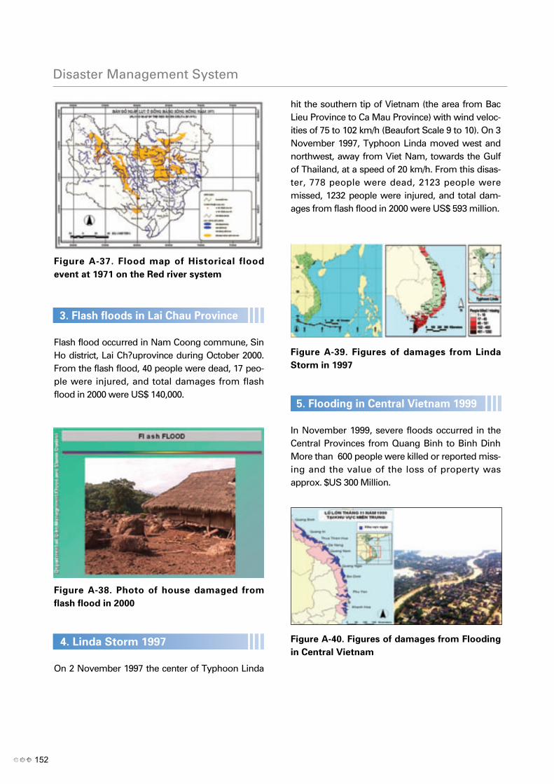
Figure A-37. Flood map of Historical flood
event at 1971 on the Red river system
3. Flash floods in Lai Chau Province
Flash flood occurred in Nam Coong commune, SinHo district, Lai Ch?uprovince during October 2000.From the flash flood, 40 people were dead, 17 peo-ple were injured, and total damages from flashflood in 2000 were US$ 140,000.
Figure A-38. Photo of house damaged from
flash flood in 2000
4. Linda Storm 1997
On 2 November 1997 the center of Typhoon Linda
hit the southern tip of Vietnam (the area from BacLieu Province to Ca Mau Province) with wind veloc-ities of 75 to 102 km/h (Beaufort Scale 9 to 10). On 3November 1997, Typhoon Linda moved west andnorthwest, away from Viet Nam, towards the Gulfof Thailand, at a speed of 20 km/h. From this disas-ter, 778 people were dead, 2123 people weremissed, 1232 people were injured, and total dam-ages from flash flood in 2000 were US$ 593 million.
Figure A-39. Figures of damages from Linda
Storm in 1997
5. Flooding in Central Vietnam 1999
In November 1999, severe floods occurred in theCentral Provinces from Quang Binh to Binh DinhMore than 600 people were killed or reported miss-ing and the value of the loss of property wasapprox. $US 300 Million.
Figure A-40. Figures of damages from Flooding
in Central Vietnam
152
Disaster Management System

6. Flooding in MeKong River in 2000: In Novem-
ber 2000, the Mekong River Delta suffered the
harshest flooding in over 40 years.
By the flooding 481 people were dead and totaldamages from this flooding were US$ 280 million.
Figure A-41. Figures of damages from Flooding
in MeKong River in 2000
7. Xangsen Typhoon in 2006
The Xangsen Typhoon is one of the most violenttyphoon in the last 20 years in Vietnam (Beaufort
scale 12, gusting Beaufort scale 13-14) which wasformed in the East sea of the Phillipines (26/9/06)and landed to Da Nang AM 1/10/06 with stabletrack, intensity and high movement speed (20km/h)shown in Figure 9. From this disaster, 66 peoplewere dead, 2 people were missed, 525 people wereinjured, and total damages from flash flood in 2000were US$ 10.375 billion.
Figure A-42. The trajectory of the Xangsen
Typhoon in 2006
Viet nam
153

For more information, please contact :World Meteorological Organization, 2009
ISBN 978-89-90564-89-4 93530
Chairperson, Publications BoardWorld Meteorological Organization (WMO)Tel.: +41 (0) 22 730 84 03Fax: +41 (0) 22 730 80 40E-mail: [email protected]
7 bis, avenue de la Paix. P.O. Box No. 2300 CH-1211 Geneva 2, Switzerland
WM
O/TD-No. 1476


![MEMBER REPORT [China] - Typhoon Committee REport/CHina/Me… · MEMBER REPORT [China] ESCAP/WMO Typhoon Committee 13th Integrated Workshop Chiang Mai, Thailand 5-9 November 2018 .](https://static.fdocuments.in/doc/165x107/5f0e10ab7e708231d43d719c/member-report-china-typhoon-reportchiname-member-report-china-escapwmo.jpg)