Wisconsin's Lakes at Risk · PDF fileor for additional copies of this report, please visit ....
33
Wisconsin’s Lakes at Risk The Growing Threat of Pollution from Agriculture and Development WISCONSIN RESEARCH & POLICY CENTER
Transcript of Wisconsin's Lakes at Risk · PDF fileor for additional copies of this report, please visit ....

Wisconsin’s Lakes at Risk The Growing Threat of Pollution
from Agriculture and Development
WISCONSINRESEARCH & POLICY CENTER

Wisconsin’s Lakes at Risk The Growing Threat of Pollution
from Agriculture and Development
Wisconsin Environment Research & Policy Center
Elizabeth Ridlington,Frontier Group
Dan Kohler, Wisconsin Environment
Research & Policy Center
March 2011

Acknowledgments
Wisconsin Environment Research & Policy Center thanks the following individuals for their review of this report: Lori Grant, River Alliance of Wisconsin; Cheryl Nenn, Mil-waukee Riverkeeper; and Julian Zelazny, Executive Director, Wisconsin Land and Water Conservation Association. The authors would also like to thank Tony Dutzik and Benjamin Davis of Frontier Group and Carolyn Kramer for their editorial assistance. Clair Embry and Hillary Jacobs provided research assistance.
The opinions expressed in this report are those of the authors and do not necessarily reflect the views of our funders or those who provided editorial review. Any factual errors are strictly the responsibility of the authors.
© 2011 Wisconsin Environment Research & Policy Center
Wisconsin Environment Research & Policy Center is a 501(c)(3) organization. We are dedicated to protecting Wisconsin’s air, water and open spaces. We investigate problems, craft solutions, educate the public and decision makers, and help Wisconsinites make their voices heard in local, state and national debates over the quality of our environment and our lives. For more information about Wisconsin Environment Research & Policy Center or for additional copies of this report, please visit www.wisconsinenvironment.org.
Frontier Group conducts independent research and policy analysis to support a cleaner, healthier and more democratic society. Our mission is to inject accurate information and compelling ideas into public policy debates at the local, state and federal levels. For more information about Frontier Group, please visit www.frontiergroup.org.
Cover photo: Milwaukee Riverkeeper Layout: Harriet Eckstein Graphic Design

Table of Contents
Executive Summary 1
Introduction 4
Runoff: What It Is and Where It Comes From 6 Pollutants in Runoff 6 Runoff Pollution Comes from Factory Farms and Development 6
Runoff Fouls Wisconsin’s Waterways 12 Nutrient Pollution Creates Algae Blooms 12Sediment Harms Fish and Aquatic Plants 14Ammonia in Manure Kills Fish 15 Bacterial Pollution Closes Beaches 16
Policy Recommendations 18
Appendix A. Permitted CAFOs by County 22
Appendix B. Waters Polluted by Runoff from Livestock Operations 24
Notes 26


Executive Summary 1
Executive Summary
Runoff pollution from farms and urban areas threatens water quality in waterbodies across Wisconsin.
Bacteria at beaches, toxic algae in lakes, and sediment in streams can make the water unsafe for drinking, swimming and boating, and limit aquatic plant and animal life.
The problem of manure-tainted runoff from factory farms presents a growing challenge to water quality in Wisconsin as the number of large animal-feeding opera-tions increases. In urban areas of the state, development and construction continue to add impervious surfaces that increase the volume of unfiltered runoff entering lakes and rivers.
Wisconsin should provide adequate funding to implement new rules limiting runoff pollution into the state’s lakes, rivers and streams.
Polluted runoff is responsible for much of the poor water quality across the state.
• Rain or melting snow that isn’t absorbed into the ground runs off of paved areas or saturated soil into
nearby streams, rivers and lakes— carrying with it a variety of pollutants, such as fertilizers, animal wastes and sediment.
• Runoff pollution contributes to the fact that 380,000 acres of Wisconsin’s lakes and reservoirs and more than 3,300 miles of streams and rivers are polluted and unable to support all the activities for which we rely on water: swimming, fishing, and supporting wildlife.
A rapid increase in the number of concentrated animal feeding operations (CAFOs), which generate large amounts of manure, has increased the threat of runoff pollution.
• The number of CAFOs in Wisconsin has increased 16-fold in the past 15 years, from 10 in 1995 to almost 160 in 2010.
• More than 50 facilities keep at least 2,000 cows in one location, with each cow producing as much as 150 pounds of manure a day.

2 Wisconsin’s Lakes at Risk
• Farmers must dispose of these huge volumes of manure. Manure is an ef-fective fertilizer for crops, but exces-sive amounts applied to a field can run off into nearby streams.
Urban stormwater pollution, another major pollution source, comes from sites under construction and existing developments.
• Construction sites are responsible for more sediment pollution of Wiscon-sin’s waters than any other source. The average construction project loses 30 tons of sediment per acre.
• From 2002 to 2007, 169,000 acres of land were developed in Wisconsin—more land than the combined areas of Milwaukee, Madison and Green Bay—disturbing soil and creating sediment pollution.
• When construction is complete, hard surfaces like rooftops and driveways funnel rain and melting snow directly to waterways without any natural filtering through vegetation. High volumes of runoff pollution during heavy rainfall can overwhelm sewer systems, spilling raw sewage directly into waterways.
Algae blooms change the ecology of lake and rivers, harming recreation and damaging wildlife.
• Blooms of algae can block sunlight from reaching other aquatic vegeta-tion, killing native plants.
• When the algae die and begin to de-cay, they lower the amount of oxygen in the water, suffocating fish or caus-ing them to flee. Nutrient pollution limits fish and other aquatic life in more than 220,000 acres of freshwater
lakes and reservoirs in Wisconsin.
• Blue-green algae release a toxin that is harmful and potentially deadly for people who ingest tainted water. When blue-green algae are present, water is unsafe for swimming and other recreational purposes. Approxi-mately 90 percent of recreation-related impairments of Wisconsin lakes and reservoirs, including Tainter Lake, are due to blooms of blue-green algae.
Sediment pollution reduces the ability of a waterway to support a full, diverse and healthy range of wildlife.
• Turbidity—high levels of suspended sediment or algae—is a problem in 150,000 acres of lakes, including the Chetek lakes.
• Runoff kills sensitive plants and animals and leaves waterways able to support only a narrow range of pollu-tion-tolerant species, as has occurred in Lake Mendota.
Bacteria-laden runoff can make wa-ters unsafe for recreational uses.
• In 2009, 7 percent of water samples collected at the most popular Great Lakes beaches in Wisconsin had ex-cessive levels of bacterial pollution and beaches were closed or deemed risky for recreation 401 times.
Wisconsin needs stronger rules to curb runoff pollution into lakes, riv-ers, streams and aquifers, preserving clean drinking water supplies, protect-ing favorite swimming and boating sites, and sustaining healthy fish and wildlife populations. In the past several years, Wisconsin has taken several steps to limit pollution. Towns and cities have had to cut sediment pollution in stormwater

Executive Summary �
runoff. Farmers must comply with some restrictions on how manure is stored and applied to fields. Most recently, the state adopted a range of new standards to limit pollution from agricultural and municipal sources. To ensure the success of these new standards and to further protect the state’s waters, Wisconsin should:
• Provide adequate resources for state and county agencies to implement these stronger standards protecting Wisconsin’s valuable lakes, rivers and
streams. The state should also in-crease the amount of funding avail-able to help cover the state’s share of capital improvements made by farmers to control pollution.
• Minimize urban and suburban runoff through careful site design, landscap-ing, and redevelopment policies.
• Reduce pollution from suspended solids in stormwater runoff.

4 Wisconsin’s Lakes at Risk
On a calm spring day, Tainter Lake presents an inviting blue contrast to the green hills surrounding it, draw-
ing visitors and residents to its shores. Yet by the end of the summer, as one resident told the Associated Press, living by Tainter Lake is “like living in the sewer for three weeks. You gag. You cannot go outside.”1
During warm weather, blooms of blue-green algae periodically turn the lake pea-soup green. When the algae die, the stench of decay fills the air and conditions in and around the lake become unbearable. Blue-green algae can release toxins into the water that cause skin irritation or respira-tory problems.2 The toxins released by the algae can also affect liver or neurological function.3 Wisconsin officials recommend that residents near Tainter Lake protect themselves by closing their windows and not walking along the edge of the lake.4 Swimming and boating are out of the ques-tion. The water can be fatal for pets, which must be kept away from it.
Tainter Lake’s algae blooms are fueled by the flow of phosphorus washing off farm fields and developed land into the water-ways that feed the lake. But while Tainter Lake’s problems with blue-green algae are extreme, the lake is not alone in feeling the effects of runoff pollution.
Across Wisconsin, runoff pollution threatens the health of our treasured rivers and lakes. In some cases, much like Tainter Lake, nutrient pollution from suburban lawns and farm fields causes algae blooms that harm fish and can sicken people. In other cases, sediment from construction sites smothers fish and plant habitat. In still other cases, pavement and other impervi-ous surfaces channel so much rainwater into combined sewer systems that those systems overflow – causing bacterial pol-lution that renders water unsafe for swim-ming.
There are solutions to Wisconsin’s runoff pollution problems. At Tainter Lake, for example, the Wisconsin Department of
Introduction

Introduction 5
Natural Resources has identified strate-gies to reduce phosphorus pollution, in-cluding greater use of no-till agriculture, testing soil for phosphorus content before spreading additional manure, and reducing manure spreading in the winter.5
Practical, common-sense steps such
as these can curb the flow of runoff into Wisconsin’s treasured rivers and lakes. The time has come to build on the solid first steps the state has already taken to address runoff pollution, so that we can prevent the emergence of new threats and restore our waterways to health.

6 Wisconsin’s Lakes at Risk
Wisconsin residents cherish our lakes and streams. Whether we use them to ice-fish in the win-
tertime, swim or boat in the summer, or simply value them for providing clean water to communities and healthy habitat for wildlife, we understand that clean water is a vital part of our quality of life.
Yet water pollution leaves many lakes, streams and rivers across the state too pol-luted for swimming or fishing, or to sustain healthy ecosystems. More than 3,300 miles of streams and rivers and 380,000 acres of lakes and reservoirs are too polluted to sus-tain their “designated uses”—swimming, fishing, or providing a healthy habitat for aquatic plants and animals.6 More than 40 percent of the lake acreage evaluated by the state of Wisconsin is considered to be in fair or poor condition.7
Pollutants in RunoffRunoff pollution is one of the biggest sources of water pollution in Wisconsin. It can contain bacteria from manure and raw
sewage; sediment washed from bare soil; unwanted nutrients, like phosphorus and nitrogen, found in fertilizers and manure; and ammonia from manure.
Rain or melting snow can carry fertil-izer, pesticides, animal wastes and soil from agricultural land into nearby lakes and streams. Tilling fields for row crops and careless spreading of manure increase runoff problems. In developed areas, water runs off rooftops, roads, parking lots and lawns, carrying oil, sediment, chemicals, fertilizer, pet waste, fallen air pollution, and other pollutants into waterways. Espe-cially heavy rainfall may overwhelm sewage treatment systems, causing them to spill raw or partially treated sewage.
Runoff Pollution Comes from Factory Farms and DevelopmentThere are several sources of the polluted runoff that taint Wisconsin’s drinking water supplies, recreational areas, and the waterways on which wildlife depends.
Runoff: What It Is and Where It Comes From

Runoff: What It Is and Where It Comes From �
Two of the biggest sources are agricul-ture—particularly factory farms—and stormwater from developed areas.
Factory FarmsPollution from factory farms with large numbers of livestock is a growing source of water contamination in Wisconsin. Livestock operations produce large quanti-ties of manure that can cause nutrient and bacterial pollution in waterways.
Manure can be a valuable source of nutrients to support robust crops. Manure contains phosphorus, nitrogen and potas-sium, essential nutrients for plant growth.8 For centuries, farmers have used manure as a fertilizer for their crops, collecting waste from the few animals they kept for their family or for the local market and spreading it on nearby fields. Today, farm-ers continue to use manure as fertilizer because it is less expensive than commercial fertilizers.
Over the past several decades, however, farming in Wisconsin has undergone a dramatic shift from family farms to fac-tory farms. The growth of large-scale livestock facilities—and the amount of manure they generate—means that many farmers have more manure available than they can safely and usefully spread on fields. A family farmer with a small herd of cows or a modest-sized flock of chickens can profitably use manure or barn waste as fertilizer. In contrast, a big dairy operation generates so much manure that getting rid of it becomes a problem for the farmer and a threat to water quality. With a larger quantity of manure, the good practices that keep manure out of waterways—such as not spreading it too close to the edge of a field—are harder to follow.
The number of large-scale animal-rais-ing operations, known as concentrated animal feeding operations (CAFOs), has increased dramatically in Wisconsin in
0
20
40
60
80
100
120
140
160
180
200
1985 1990 1995 2000 2005 2010
Num
ber
of p
erm
itte
d op
erat
ions
Year
Beef
Swine
Poultry
Dairy
Note: The number of poultry operations in the state has not declined. The Department of Natural Resources changed how it permitted poultry facilities operated by Jennie-O Turkey Store in 2002. Multiple facilities are now covered by one permit.
Figure 1. Number of Permitted CAFOs by Year12

8 Wisconsin’s Lakes at Risk
the past 15 years. In Wisconsin, a facility is considered a CAFO if it has 700 dairy cows, 1,000 beef cattle, 55,000 turkeys, or 100,000 laying chickens.9 In 1995, fewer than 10 dairy operations were large enough to be considered CAFOs. Ten years later, in 2005, nearly 120 locations were identified as CAFOs, and by 2010 that figure had risen to nearly 160.10 (See Figure 1.) Most of the CAFOs in Wisconsin are dairy operations, and of those, more than 50 have at least 2,000 cows in one location.11 CAFOs are located in counties across the state. (See Figure 2.)
Figure 2. CAFOs Are Located Across Wisconsin13
Large operations that do not quite meet the threshold for regulation as CAFOs have increased also. From 1997 to 2007, the percentage of cows in herds with fewer than 200 dairy cows declined by one third, while the percentage of cows in herds of 200 to 499 cows increased by 71 percent.14 (See Figure 3.) The number of cows in herds of 500 to 999—which may or may not be regulated as CAFOs—increased even faster, rising 450 percent.
Given that a single dairy cow can produce 150 pounds of manure a day, an operation with 700 cows generates 105,000

Runoff: What It Is and Where It Comes From �
pounds of manure every day, or as much pollution as could be produced by 12,600 people.16 This also means that facilities that are not technically CAFOs can nonetheless produce large amounts of pollution.
The Wisconsin Department of Natural Resources (DNR) lists pollution from CAFOs with water pollution permits as a contributing factor in the degradation of several lakes and rivers around the state.17 Phosphorus pollution from CAFOs pollutes
1 to 4926%
50 to 9944%
100 to 19918%
200 to 4999%
500 to 9992%
1,000 or more
1%
Herd Size1997
Figure 3. Big Dairy Herds Have Become More Common Since 1997 (percent of cows by herd size)15
the Red Cedar River and Tainter Lake in Dunn County, feeding blooms of toxic algae. CAFOs produce bacterial pollution in Sheboygan County’s Otter Creek, limit-ing the use of that stream for recreation. Phosphorus and sediment in Neshonoc Lake are causing eutrophication, over-fertilization that causes excessive aquatic plant growth. See Appendix B for the full list of waterways impaired by livestock-related activities.
1 to 4915%
50 to 9932%
100 to 19919%
200 to 49917%
500 to 9999%
1,000 or more
8%
Herd Size2007

10 Wisconsin’s Lakes at Risk
Runoff from smaller animal feeding operations pollutes lakes and rivers, too. In Brown and Outagamie counties, pollution from animal feeding operations adds phos-phorus and ammonia to Dutchman Creek, compounding other pollution problems that have led to chronic aquatic toxicity for fish and other animals and low levels of dissolved oxygen.
DevelopmentDevelopment is another major source of runoff pollution in Wisconsin, affect-ing communities across the state. The construction of new roads and buildings disturbs the landscape, impairing its ability to soak up water and increasing the amount of sediment that runs off. Even when the construction phase is over, runoff pollution problems continue as those new facilities direct greater amounts of water directly into streams and waterbodies.
Pollution During ConstructionAt the beginning of construction, all plants are stripped from a site so that the land can be leveled and graded. Drainage ditches or storm sewers might be built as part of the site’s basic infrastructure, before buildings and parking lots are completed. Then, the soil sits bare and exposed to rain and melting snow for the duration of construction. Without plants to slow it down, water flows more quickly, eroding the soil, which may have phos-phorus attached to it. Drainage ditches efficiently carry that sediment and phos-phorus pollution into streams.
While agricultural activities can also produce sediment pollution, construction sites are responsible for more sediment pollution of Wisconsin’s waters than any other source. The average construction project delivers 30 tons of sediment into nearby waterways for every acre under
0
20
40
60
80
100
120
140
160
180
200
1982-1987 1987-1992 1992-1997 1997-2002 2002-2007
New
ly D
evel
oped
Lan
d (t
hous
ands
of a
cres
)
Figure 4. New Land Development in Wisconsin23

Runoff: What It Is and Where It Comes From 11
development.18 In contrast, an acre of cropland loses one to 10 tons annually.19
According to recent data compiled by the DNR, sediment pollution is a wide-spread problem aff licting Wisconsin’s waterways. Sediment contributes to the impairment of 1,800 miles of rivers and streams and 183,000 acres of inland lakes, including Lake Winnebago.20
Land development—and the sediment pollution that results—has occurred at a rapid clip for years. (See Figure 4.) From 2002 to 2007, 169,000 acres of land have been developed in Wisconsin, or 34,000 acres per year.21 That’s bigger than the combined areas of the cities of Milwaukee, Madison and Green Bay.22
Pollution After ConstructionExtensive development has an impact on water quality even after construction is completed. Development covers natural land with impervious surfaces—roads, driveways, roofs and other hard surfaces that prevent rainwater and snowmelt from being absorbed directly into the ground.
The amount and location of impervious surface in watersheds is closely connected to the health of downstream waterways. Watersheds with a large amount of forested cover, a large riparian buffer, and low levels of impervious surface tend to have better water quality. Water quality problems tend to become apparent when 5 to 10 percent of a watershed is covered with impervious surfaces. Adding more impervious surface leads to more serious water quality prob-lems.24 When a watershed is developed to the point where 15 percent or more of the land is impervious, water quality degrada-tion accelerates quickly.25
Impervious surfaces generate runoff pollution. Rooftops and paved surfaces typically are designed with gutters and
drains to channel rain and melting snow away from the development and straight into sewers or creeks. This direct route of runoff into waterways means there is no opportunity for vegetation or soil to filter out pollutants.
Runoff from developed areas can con-tain sediment, toxics, salt, pet and wildlife wastes, oil, organic material and other contaminants. Common toxics include pollutants from vehicles, including lead and zinc, which are hazardous to human health and can kill aquatic life.26 Pesticides are also common in urban runoff. A million gallons of water draining from a commer-cial area will contain 1,500 pounds of sus-pended solids, 2.6 pounds of phosphorus, 31 pounds of nitrogen, and 3.3 pounds of toxic metals.27
Bacterial contamination can occur when high volumes of water runoff from devel-oped areas overwhelm combined sewage and storm sewer systems. Unlike natural areas, streets, sidewalks, parking lots and buildings do not absorb any water; instead, these impervious surfaces channel water toward streams and storm sewers. In cit-ies with antiquated combined sewage and storm sewer systems such as Milwaukee, the high volume of water that enters the system during storms can be overwhelm-ing, causing the release of raw or partially treated sewage.
Pet and wildlife wastes also can generate bacterial pollution. A 2001 to 2003 study of fecal contamination in the water at Lake Michigan’s South Shore Beach near Mil-waukee found that much of the pollution came from waste left by ring-billed gulls and waterfowl on paved areas near the boat ramp. A paved parking lot the size of two city blocks drained down the boat ramp into the lake, depositing fecal material directly into the water.28

12 Wisconsin’s Lakes at Risk
With nearly 3 percent of the state covered in lakes, Wisconsin has abundant fish and aquatic animal
populations, and offers lots of opportuni-ties for water recreation.29 Both swimming and boating are popular pastimes – Wis-consin, for example, has roughly 500,000 registered motorboats in the state, or nearly one for every 11 residents.30 However, run-off pollution reduces the ability of water-ways to support a full, diverse and healthy range of wildlife. It also limits recreational opportunities.
Nutrient Pollution Creates Algae BloomsNutrients found in manure and fertilizer, such as phosphorus and nitrogen, can help crops grow, but when those nutrients are carried into waterways they promote growth of aquatic vegetation where it might not normally occur. This vegetation degrades waterways.
In unpolluted lakes and streams, lack of phosphorus typically limits plant growth.31
When phosphorus is added, algae flourish. Even a small amount of phosphorus pol-lution can trigger algae growth: a single pound of phosphorus can support the growth of 500 pounds of algae.32
In waters across the state, blooms of blue-green algae, or cyanobacteria, limit recreation.33 At 99 percent of reservoirs and 91 percent of freshwater lakes that are listed as impaired, blue-green algae were the cause of the recreation-related impair-ment noted by the Department of Natural Resources. People who are exposed to blue-green algae can suffer a variety of health consequences, including stomach cramps, vomiting, diarrhea, difficulty breathing, fever and muscle weakness.34 Blue-green algae also present a threat to dogs, causing illness or death.35
The presence of large amounts of algae, whether blue-green algae or other variet-ies, changes the ecology of the waterbody. Algae floating near the surface block sun-light from reaching aquatic plants in deeper water, stifling their growth or killing them. When the algae die and decay, they cause concentrations of dissolved oxygen in the water to plummet. If oxygen levels are too low, aquatic vegetation fails to thrive,
Runoff Fouls Wisconsin’s Waterways

Runoff Fouls Wisconsin’s Waterways 1�
while fish must flee or they will suffocate. Ultimately, the most sensitive plants and animals are killed or forced to move, leav-ing behind only a narrow range of pollu-tion-tolerant species.36 This process affects more than 220,000 acres of freshwater lakes and reservoirs in Wisconsin.37
Nutrient Pollution Case Study: Algae Blooms on Lake MendotaLake Mendota is a central feature of Madi-son. Downtown Madison and the Wiscon-sin state capitol grounds lie on an isthmus between Lake Mendota and Lake Monona. The 22-mile-long shore of Lake Mendota is lined with parks, boat launches, private homes, and the University of Wisconsin campus.38
Pollution has marred Lake Mendota, limiting its use as a recreation site and its ability to support a fully functioning eco-system. The biggest source of pollution in Lake Mendota is from farms and livestock operations located in the lake’s 217-square-mile watershed.39 This pollution enters the Yahara River, which delivers excessive sediment and nutrients to the lake. Some previous sources of pollution, such as un-treated sewage, have been eliminated, but
other sources of pollution persist, includ-ing erosion from construction sites and stormwater runoff from paved areas. The pollution flows both directly into Lake Mendota and into its tributaries. Accidental spills remain a problem, too, such as a 2005 manure spill in Dorn Creek.40
This pollution has changed the ecol-ogy of the lake. Many native plant species such as wild celery, slender naiad, water crowfoot, muskgrass and several variet-ies of pondweed have dwindled or been eliminated entirely.41 Some species of fish have disappeared, too, including banded killifish, blackstripe topminnow, blackchin shiner, and others. The lake still supports a variety of sport fish, including walleye, perch, bass, panfish and muskellunge.42
Another consequence of phosphorus and nitrogen pollution is algae blooms, such as of toxic blue-green algae.
In 2008, an 18-year-old University of Wisconsin student became ill after swim-ming in Lake Mendota during a blue-green algae bloom. She received treatment in the emergency room, but four days after swimming, the student was still experienc-ing an upset stomach, a rash, joint pain, a headache, and fatigue.43 The student swam
Lake Mendota in the fall, as viewed from University Bay Landing. Credit: Daniel J. Simanek

14 Wisconsin’s Lakes at Risk
with friends at a swimming area popular with University of Wisconsin students; a lifeguard employed by the university keeps watch over the swimming area during the day. Because the ill student swam after dark, the blue-green algae bloom wasn’t visible.
In the broader Madison area, blue-green algae blooms sickened at least four people in the summer of 2008, including the owner of a lake-front home who cleaned weeds from the water.44
Water quality in Lake Mendota has be-gun to improve. In 1980, the water was so clouded with sediment that aquatic plants could not grow in water deeper than 7 feet because they did not receive enough sunlight.45 In recent years, however, plants have been able to return to depths as great as 16 feet thanks to clearer water. Yet fully restoring Lake Mendota will require more work. As of 2000, the Lake Mendota water-shed contained so much excess phosphorus that it would require three centuries with no additional phosphorus pollution to re-turn the watershed to normal levels.46
In 2010, Dane County received a grant to conduct soil testing on 7,500 acres of farmland in the Lake Mendota watershed.47 The results of the soil tests should help
reduce pollution from agricultural sources. Test data will help farmers better calibrate the amount of fertilizer that they apply to their fields and reduce nutrient pollution that ends up in Lake Mendota.
Sediment Harms Fish and Aquatic PlantsSediment pollution narrows the range of plants and animals able to survive in a waterway. Sediment can smother aquatic vegetation, insects, fish eggs, or newly hatched fish.48 As sediment accumulates in streams, it can cover gravel bars that pro-vide habitat for spawning fish. Ultimately, if enough sediment is deposited in a stream, it can alter the flow of water, leading to streambank erosion.49
When suspended in the water, sediment reduces water clarity and limits how much light reaches aquatic plants, retarding growth. Silty streams may also become warmer as the dark soil retains more of the sun’s heat, potentially raising the water temperature to unhealthy levels for fish.50 High sediment levels affect 150,000 acres of lakes in Wisconsin.51
Turbidity Case Study: Declining Water Clarity in the Chetek LakesThe Chetek Lakes—Prairie Lake, Mud Lake, Pokegama Lake, Lake Chetek and Ten Mile Lake, in Barron County—have become more polluted in the past decade. The lakes contain high levels of phospho-rus, which support excessive algae and in-vasive species such as curlyleaf pondweed. This growth can deprive fish of oxygen and impair water clarity that can harm native plants. Measurements of water transpar-ency taken in 2008 show that all the lakes are much cloudier than they were in 1996.52 (See Figure 5.)
A satellite image of Lake Mendota (larger lake) and Lake Menona, surrounded by Madison. The swirls are algae blooms, digitally high-lighted to make them easier to see. Credit: UW SSEC and WisconsinView.

Runoff Fouls Wisconsin’s Waterways 15
No major industrial facility drains into the lakes; rather, nearly half the phospho-rus in the lakes comes from cropland, with much of the rest coming from livestock operations and perhaps increased recy-cling of phosphorus already in the lake.54 Manure that is washed off feedlots or off
fields where it has been spread as fertilizer adds phosphorus to the lakes. Particles of soil eroded from plowed fields add both phosphorus and sediment pollution. Phos-phorus that isn’t carried downstream even-tually settles into sediment at the bottom of the lake, and if that sediment is disturbed the phosphorus can feed the growth of a new generation of algae.
Ammonia in Manure Kills FishThe slow build-up of nutrient and sediment pollution isn’t the only way that runoff pollution harms fish. A sudden influx of manure-laden runoff can kill fish almost instantly, as the ammonia in manure dam-ages the gills of fish.55 In a 12-month period
0
0.2
0.4
0.6
0.8
1
1.2
Prairie Lake Pokegama Lake Lake Chetek Ten Mile Lake Mud Lake
Wat
er T
rans
pare
ncy
(met
ers)
1996
2008
Figure 5. Water Clarity Has Declined in Chetek Lakes Since 199653
Fish killed by manure that ran off a frozen field. Credit: WI DNR.

16 Wisconsin’s Lakes at Risk
in 2004-2005, DNR received reports of 59 incidents where manure entered waterways and in more than a dozen of those cases caused fish kills.56 (See photo on p. 15.)
Bacterial Pollution Closes BeachesAlong Lake Superior and Lake Michigan, Wisconsin residents have access to the wa-ter at 192 beaches, with a total of 55 miles of beach.57 However, bacterial pollution at these beaches often makes swimming unsafe.
Overflows from combined sanitary and storm sewers periodically pollute Wiscon-sin waters. In the summer of 2010, heavy rain caused the combined sanitary and storm sewers in Milwaukee and 10 other municipalities to overflow.58 In June 2009, several sewer systems in the Milwaukee area overflowed after the area received as much as six inches of rain.59 Nearly 1 billion gallons of raw sewage were dumped into local waterbodies. Just a year earlier, heavy rainfall caused almost 3 billion gallons of sewage to enter waterways.
Sewage introduces bacterial pollution to water, increasing the risk that people who come in contact with the water or ingest it will get sick. In 2009, 7 percent of water samples collected at the most popular Great Lakes beaches had excessive levels of bac-terial pollution.60 Each positive test result
Table 1. Bacterial Pollution at Wisconsin’s Great Lakes Beaches in 200962
County
Ashland 7 7
Bayfield 16 0
Brown 3 3
Door 31 126
Douglas 12 2
Iron 5 0
Kenosha 5 32
Kewaunee 2 4
Manitowoc 9 9
Milwaukee 11 109
Oconto 0 0
Ozaukee 7 41
Racine 2 8
Sheboygan 8 60
Statewide 118 401
# of Beach-es Where
Water Was Sampled
Number of Days with Closings or Advisories
triggered either a prohibition on swim-ming until bacterial levels declined, or an advisory to swimmers to avoid ingesting lake water, to shower after swimming, or to wash hands after swimming and before eating.61 Some closings occurred and advi-sories were issued when there was strong reason to expect a test, which can take up to 24 hours to complete, would come back positive. Table 1 shows the number of clos-ings and advisories by county.

Runoff Fouls Wisconsin’s Waterways 1�
Bacterial and Nitrate Pollution from Manure Can Enter Groundwater
In addition to polluting streams and lakes with bacteria and nutrients, manure can also taint groundwater that is used for drinking water.
The problem is particularly common in northeast Wisconsin, which is known for having karst topography, where fractured bedrock is covered by only a small amount of soil. As a result, the groundwater is vulnerable to contamination.63 In contrast, in other areas of the state, soil is deep enough to filter out contaminants from nitrogen and bacteria in manure and septic systems that are present on the surface, keeping the groundwater clean. In the northeast Wisconsin counties of Brown, Calumet, Door, Kewaunee and Manitowoc, however, soil depth ranges from a mere couple of inches to a few feet, allowing water that has been barely filtered to find its way into aquifers. Sinkholes, fractured rock and rock outcroppings can allow surface runoff to flow directly into groundwater. Repeatedly, manure produced by the thousands of cows raised in northeastern Wisconsin has entered groundwater, polluting drinking water wells and water supplies.
The town of Morrison, in Brown County, supports 41,000 dairy cows that pro-duce a total of 260 million gallons of manure annually.64 That manure frequently is spread on nearby fields as fertilizer. In 2006, Brown County experienced an early thaw. Just days after temperatures turned upward, the thawing of manure-covered fields resulted in coliform bacteria, E. coli, and nitrate pollution in more than 100 wells.65 Residents who drank or bathed in the water suffered from various ailments including diarrhea, stomach pains and ear infections.
Tests of private drinking water wells in Kewaunee County from mid-2004 to mid-2006 showed significant contamination.66 Of the 173 wells that were tested, nearly one fifth had bacterial contamination—likely from manure-tainted runoff—that made the water unsafe for human consumption. Nitrate pollution, which can come from ma-nure or fertilizer, affected more than half the wells: 18 percent had nitrate levels that exceeded the health standard for drinking water, and another 35 percent had nitrate levels above background levels but below the level that threatens human health.
The bacterial pollution from manure may include antibiotic resistant bacteria. A study of surface and groundwater below a swine feedlot found higher levels of bac-teria and a higher percentage of antibiotic resistant bacteria than in waters upstream from the feedlot.67 Livestock in CAFOs often are treated with antibiotics to help them grow faster and to limit the spread of disease between animals kept in such close quarters. This overuse of antibiotics can lead to bacteria that are resistant to antibiotics. People who become ill from water polluted with resistant bacteria may be more difficult to treat and be sick for longer.
Field-spreading of manure is not the only source of water pollution. Poor manure management by farmers also can be a problem. The state recently settled a lawsuit with the Gold Dust Dairy in Brown County for allowing its manure pit to overflow into a nearby waterway and for storing other manure in a three-sided building that allowed manure to run off. In addition to promising to fix the problems, the dairy had to pay an $80,000 fine to implement and enforce the new regulations.68

18 Wisconsin’s Lakes at Risk
Effective action is needed to reduce run-off pollution and restore Wisconsin’s waterways to health.
In recent years, Wisconsin has taken several steps to limit runoff pollution. In 2002, Wisconsin passed a law to reduce pollution from stormwater. The law re-quires municipalities to reduce the volume of total suspended solids in their stormwa-ter runoff by 20 percent by 2008 and by 40 percent by 2013.69 That legislation also required improved pollution control from construction sites and farms. Farmers were required to reduce manure runoff if the state subsidized 70 percent of the cost of improvements to contain pollution. More recently, the state adopted a ban on phos-phorus in lawn and golf course fertilizer, which should lower the amount of nutrients getting into waterways.
Despite this progress in recent years, too much pollution still makes its way into Wisconsin’s lakes, rivers and streams, leading to massive algae blooms, limit-ing aquatic biodiversity, and causing other problems. New sources of pollution threaten the state’s waters, as the number of factory farms in Wisconsin has tripled in the last decade and new development
continues to add impervious surfaces.70
Wisconsin needs strong action to curb runoff pollution into lakes, rivers, streams and aquifers, preserving clean drinking wa-ter supplies, protecting favorite swimming and boating sites, and sustaining healthy fish and wildlife populations.
In 2011, the state adopted a set of rules to better protect waterways. The rules include:
• A science-based phosphorus standard for soils. If a field already has enough phosphorus to support healthy crop growth, any additional phosphorus that is applied to the field in the form of manure or fertilizer is likely to run off into nearby waters. If a farmer chooses to meet a crop’s need for nitrogen by applying manure, the field will likely receive excessive levels of phosphorus. To comply with a phos-phorus standard, farmers will need to perform a simple soil test before applying more phosphorus.
Soil testing is important because even if a farmer is being careful about how and when manure is applied to fields,
Policy Recommendations

Policy Recommendations 1�
it is still possible to inadvertently apply excessive amounts of manure. Manure contains a set ratio of ni-trogen to phosphorus. If a farmer applies manure as fertilizer based on how much nitrogen the crop needs, the field may be supersaturated with phosphorus. For example, an acre of alfalfa may need 200 pounds of nitro-gen to flourish, but just 40 pounds of phosphorus.71 Yet if the farmer applies enough manure from a dairy lagoon to meet the crop’s nitrogen need, the soil will contain far too much phos-phorus. Manure from a dairy lagoon can contain 80 pounds of phosphorus for every 100 pounds of nitrogen, or 120 pounds more than a field of alfalfa needs. The excess phosphorus can be carried off the field and into nearby waterways through erosion of phos-phorus-heavy soil or if it is dissolved by rainwater.
• Better control of runoff pollution from sources draining into impaired waterways.
• Buffers between streams and the plowed areas of fields. Untilled areas of grass and trees can help slow the runoff of water from a cultivated field, allowing sediments and pollutants to be filtered out. The roots of these established plants also help to stabilize stream banks and reduce pollution from erosion. A wider buffer provides greater protection, as well as better habitat for wildlife.
• Limits on runoff from feedlots, milk houses and other sources.
• Stronger limits on the acceptable amount of sediment pollution from construction sites.
• More protection for high-quality
wetlands by requiring 75-foot-wide vegetative buffers between construc-tion areas and vulnerable areas.
While these rules are a strong step for Wisconsin, there is more the state can do to protect Wisconsin’s valuable lakes, rivers and streams, including strong implementa-tion of these new rules and adopting addi-tional protections. Wisconsin should:
• Provide adequate resources for state and county agencies to implement and enforce the new regulations.
• Increase funding for capital im-provements. The state’s runoff pollu-tion regulations promise that the state will pay 70 percent of the cost of capi-tal improvements needed by farmers to cut runoff pollution. Though the state has provided significant funding in recent years for upgrades, many opportunities for reducing pollution remain. Increased funding to upgrade agricultural and municipal pollution control systems would help reduce the flow of nutrients into Wisconsin’s waterways.
Manure running off a field. In the winter months, frozen soil cannot absorb the waste, and melting snow carries it into streams in the spring. Credit: WI DNR.

20 Wisconsin’s Lakes at Risk
• Minimize urban and suburban runoff. At new development locations, careful site design can help the built environment function more like the natural environment. This means including more vegetation (particu-larly native plants), using absorbent surfaces, and designing landscaping to slow the flow of water, allowing it to soak into the ground. Existing urban and suburban areas can be remodeled with rain gardens and a reduction in impervious surfaces, such as with more green space or the use of per-meable pavement. Landscaping that allows greater absorption of precipi-tation often has the added benefit of creating more space for recreation and enhancing the appearance of
urban areas. On a broader scale, smart growth practices reduce the area of impact and protect critical parts of the ecosystem by using strategic open spaces, infill development, town center redevelopment, and clustered, higher-density design to minimize runoff in the aggregate.
• Address other sources of water pol-lution. Municipalities should further reduce the amount of suspended solids in stormwater runoff. Under Wiscon-sin’s 2002 law, municipalities have cut suspended solids by 20 percent com-pared to 2004 levels. They must con-tinue to invest in upgrades so that by 2013, suspended solids are reduced by 40 percent compared to 2004 levels.

Appendices 21
Appendices

22 Wisconsin’s Lakes at Risk
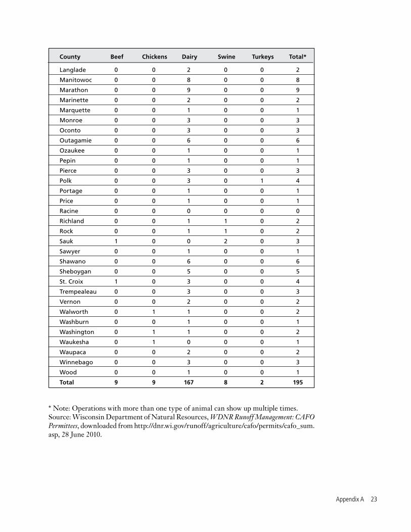
County Beef Chickens Dairy Swine Turkeys Total*
Adams 0 0 1 0 0 1
Barron 0 0 5 0 1 6
Brown 1 0 16 0 0 17
Buffalo 0 0 3 0 0 3
Calumet 0 0 5 0 0 5
Chippewa 0 0 1 1 0 2
Clark 0 0 6 0 0 6
Columbia 1 1 1 0 0 3
Crawford 0 0 0 0 0 0
Dane 2 1 4 0 0 7
Dodge 1 0 3 0 0 4
Door 0 0 1 0 0 1
Dunn 0 0 3 0 0 3
Fond Du Lac 0 0 12 0 0 12
Grant 0 0 1 1 0 2
Green 0 0 3 0 0 3
Green Lake 0 0 2 0 0 2
Jackson 0 0 3 1 0 4
Jefferson 1 4 4 0 0 9
Juneau 0 0 1 0 0 1
Kewaunee 1 0 13 0 0 14
La Crosse 0 0 0 1 0 1
Lafayette 0 0 4 0 0 4
Appendix A. Permitted CAFOs by County
Appendix A 2�
County Beef Chickens Dairy Swine Turkeys Total*
Langlade 0 0 2 0 0 2
Manitowoc 0 0 8 0 0 8
Marathon 0 0 9 0 0 9
Marinette 0 0 2 0 0 2
Marquette 0 0 1 0 0 1
Monroe 0 0 3 0 0 3
Oconto 0 0 3 0 0 3
Outagamie 0 0 6 0 0 6
Ozaukee 0 0 1 0 0 1
Pepin 0 0 1 0 0 1
Pierce 0 0 3 0 0 3
Polk 0 0 3 0 1 4
Portage 0 0 1 0 0 1
Price 0 0 1 0 0 1
Racine 0 0 0 0 0 0
Richland 0 0 1 1 0 2
Rock 0 0 1 1 0 2
Sauk 1 0 0 2 0 3
Sawyer 0 0 1 0 0 1
Shawano 0 0 6 0 0 6
Sheboygan 0 0 5 0 0 5
St. Croix 1 0 3 0 0 4
Trempealeau 0 0 3 0 0 3
Vernon 0 0 2 0 0 2
Walworth 0 1 1 0 0 2
Washburn 0 0 1 0 0 1
Washington 0 1 1 0 0 2
Waukesha 0 1 0 0 0 1
Waupaca 0 0 2 0 0 2
Winnebago 0 0 3 0 0 3
Wood 0 0 1 0 0 1
Total 9 9 167 8 2 195
* Note: Operations with more than one type of animal can show up multiple times.Source: Wisconsin Department of Natural Resources, WDNR Runoff Management: CAFO Permittees, downloaded from http://dnr.wi.gov/runoff/agriculture/cafo/permits/cafo_sum.asp, 28 June 2010.

24 Wisconsin’s Lakes at Risk
Waterbody Name County Runoff-Related Pollutants Impact of Pollution Livestock-Related Sources of Pollution
Apple Creek Brown, Outagamie Phosphorus, Sediment Low dissolved oxygen, Elevated water temperature, Livestock grazing or feeding Degraded habitat Ashwaubenon Creek Brown Phosphorus, Sediment Low dissolved oxygen, Degraded habitat Livestock grazing or feedingBabb Creek Sauk Sediment Degraded habitat Livestock grazing or feedingBacon Branch Grant Sediment Degraded habitat Livestock grazing or feedingBeaver Dam River Dodge Phosphorus, Sediment Low dissolved oxygen, Degraded habitat Permitted runoff from CAFOsBecky Creek Rusk E. coli, Sediment Degraded habitat, Recreational restrictions Livestock grazing or feeding, Dairy operationsBlack River Clark unknown Low dissolved oxygen Dairy operations (Hwy H To Rock Creek)Blue River Iowa Sediment Degraded habitat Livestock grazing or feedingBower Creek Brown Phosphorus, Sediment Low dissolved oxygen, Degraded habitat Livestock grazing or feedingBuell Valley Creek Buffalo Sediment Degraded habitat Livestock grazing or feedingCoon Creek Dunn Sediment Elevated water temperature, Degraded habitat Livestock grazing or feedingCulver Branch Grant Sediment Degraded habitat Livestock grazing or feedingDutchman Creek Brown Phosphorus, Ammonia Chronic aquatic toxicity, Low dissolved oxygen Livestock grazing or feedingDutchman Creek Outagamie Phosphorus, Ammonia Chronic aquatic toxicity, Low dissolved oxygen Livestock grazing or feedingEagle Creek Buffalo Sediment Degraded habitat Livestock grazing or feedingEast River Brown, Calumet Phosphorus, Sediment Chronic aquatic toxicity, Low dissolved oxygen, Livestock grazing or feeding Degraded habitat Finley Lake Chippewa Phosphorus, Sediment Eutrophication, Degraded habitat Livestock grazing or feedingIrish Valley Creek Buffalo Sediment Degraded habitat Livestock grazing or feedingJohnson Coulee Creek La Crosse Sediment Degraded habitat Livestock grazing or feedingJohnson Creek Jefferson Sediment Degraded habitat Livestock grazing or feedingJoos Valley Creek Buffalo Sediment Degraded habitat Livestock grazing or feedingLittle Lake Wissota Chippewa Phosphorus, Sediment Eutrophication Livestock grazing or feedingLong Coulee Creek La Crosse Sediment Degraded habitat Livestock grazing or feedingLouisburg Creek Grant Sediment Degraded habitat Livestock grazing or feedingMartin Branch Grant Sediment Degraded habitat Livestock grazing or feedingMartinville Creek Grant Sediment Degraded habitat Livestock grazing or feedingMissouri Creek Dunn Sediment Degraded habitat Livestock grazing or feedingMoon Bay Chippewa Phosphorus Eutrophication Livestock grazing or feedingNeenah Slough Winnebago Phosphorus Low dissolved oxygen Livestock grazing or feedingNeshonoc Lake La Crosse Phosphorus, Sediment Eutrophication Permitted runoff from CAFOsNorth Branch of Pike River Kenosha, Racine Sediment, unknown Chronic aquatic toxicity, degraded habitat Dairy operationsNorth Creek Trempealeau Sediment Degraded habitat Livestock grazing or feedingOtter Creek Sheboygan E. coli Recreational restrictions Permitted runoff from CAFOsPheasant Branch Dane Phosphorus, Sediment Low dissolved oxygen, Degraded habitat Livestock grazing or feedingPrairie Lake Barron Phosphorus Degraded habitat Permitted runoff from CAFOsPrintz Creek Monroe Sediment Degraded habitat Livestock grazing or feedingRed Cedar River Dunn Phosphorus Eutrophication Permitted runoff from CAFOs, Livestock grazing or feedingRoaring Creek Jackson Sediment Degraded habitat Livestock grazing or feedingRock River Rock Phosphorus, Sediment Low dissolved oxygen, Degraded habitat Livestock grazing or feedingRogers Branch Grant Phosphorus, Sediment Low dissolved oxygen, Degraded habitat Livestock grazing or feedingSilver Lake Manitowoc Phosphorus Fish kills Livestock grazing or feedingSteel Brook Jefferson Phosphorus, Sediment Low dissolved oxygen, Elevated water temperature, Livestock grazing or feeding Degraded habitatStevens Creek Rock Sediment Degraded habitat Livestock grazing or feedingTainter Lake Dunn Phosphorus Eutrophication Permitted runoff from CAFOsTappen Coulee Creek Trempealeau Sediment Elevated water temperature Livestock grazing or feedingTrump Coulee Creek Jackson, Trempealeau Phosphorus, Sediment Low dissolved oxygen, Degraded habitat Livestock grazing or feedingWillow River (140 Ave to 100th St.) Saint Croix Phosphorus Low dissolved oxygen Livestock grazing or feedingYahara River Dane, Rock Phosphorus, Sediment Low dissolved oxygen, Degraded habitat Livestock grazing or feedingYeager Valley Creek Buffalo Sediment Degraded habitat Livestock grazing or feeding
Appendix B. Waters Polluted by Runoff from Livestock Operations Most of the impaired waters in Wisconsin are polluted by multiple sources. The table below highlights livestock-related pollution only.

Appendix B 25
Waterbody Name County Runoff-Related Pollutants Impact of Pollution Livestock-Related Sources of Pollution
Apple Creek Brown, Outagamie Phosphorus, Sediment Low dissolved oxygen, Elevated water temperature, Livestock grazing or feeding Degraded habitat Ashwaubenon Creek Brown Phosphorus, Sediment Low dissolved oxygen, Degraded habitat Livestock grazing or feedingBabb Creek Sauk Sediment Degraded habitat Livestock grazing or feedingBacon Branch Grant Sediment Degraded habitat Livestock grazing or feedingBeaver Dam River Dodge Phosphorus, Sediment Low dissolved oxygen, Degraded habitat Permitted runoff from CAFOsBecky Creek Rusk E. coli, Sediment Degraded habitat, Recreational restrictions Livestock grazing or feeding, Dairy operationsBlack River Clark unknown Low dissolved oxygen Dairy operations (Hwy H To Rock Creek)Blue River Iowa Sediment Degraded habitat Livestock grazing or feedingBower Creek Brown Phosphorus, Sediment Low dissolved oxygen, Degraded habitat Livestock grazing or feedingBuell Valley Creek Buffalo Sediment Degraded habitat Livestock grazing or feedingCoon Creek Dunn Sediment Elevated water temperature, Degraded habitat Livestock grazing or feedingCulver Branch Grant Sediment Degraded habitat Livestock grazing or feedingDutchman Creek Brown Phosphorus, Ammonia Chronic aquatic toxicity, Low dissolved oxygen Livestock grazing or feedingDutchman Creek Outagamie Phosphorus, Ammonia Chronic aquatic toxicity, Low dissolved oxygen Livestock grazing or feedingEagle Creek Buffalo Sediment Degraded habitat Livestock grazing or feedingEast River Brown, Calumet Phosphorus, Sediment Chronic aquatic toxicity, Low dissolved oxygen, Livestock grazing or feeding Degraded habitat Finley Lake Chippewa Phosphorus, Sediment Eutrophication, Degraded habitat Livestock grazing or feedingIrish Valley Creek Buffalo Sediment Degraded habitat Livestock grazing or feedingJohnson Coulee Creek La Crosse Sediment Degraded habitat Livestock grazing or feedingJohnson Creek Jefferson Sediment Degraded habitat Livestock grazing or feedingJoos Valley Creek Buffalo Sediment Degraded habitat Livestock grazing or feedingLittle Lake Wissota Chippewa Phosphorus, Sediment Eutrophication Livestock grazing or feedingLong Coulee Creek La Crosse Sediment Degraded habitat Livestock grazing or feedingLouisburg Creek Grant Sediment Degraded habitat Livestock grazing or feedingMartin Branch Grant Sediment Degraded habitat Livestock grazing or feedingMartinville Creek Grant Sediment Degraded habitat Livestock grazing or feedingMissouri Creek Dunn Sediment Degraded habitat Livestock grazing or feedingMoon Bay Chippewa Phosphorus Eutrophication Livestock grazing or feedingNeenah Slough Winnebago Phosphorus Low dissolved oxygen Livestock grazing or feedingNeshonoc Lake La Crosse Phosphorus, Sediment Eutrophication Permitted runoff from CAFOsNorth Branch of Pike River Kenosha, Racine Sediment, unknown Chronic aquatic toxicity, degraded habitat Dairy operationsNorth Creek Trempealeau Sediment Degraded habitat Livestock grazing or feedingOtter Creek Sheboygan E. coli Recreational restrictions Permitted runoff from CAFOsPheasant Branch Dane Phosphorus, Sediment Low dissolved oxygen, Degraded habitat Livestock grazing or feedingPrairie Lake Barron Phosphorus Degraded habitat Permitted runoff from CAFOsPrintz Creek Monroe Sediment Degraded habitat Livestock grazing or feedingRed Cedar River Dunn Phosphorus Eutrophication Permitted runoff from CAFOs, Livestock grazing or feedingRoaring Creek Jackson Sediment Degraded habitat Livestock grazing or feedingRock River Rock Phosphorus, Sediment Low dissolved oxygen, Degraded habitat Livestock grazing or feedingRogers Branch Grant Phosphorus, Sediment Low dissolved oxygen, Degraded habitat Livestock grazing or feedingSilver Lake Manitowoc Phosphorus Fish kills Livestock grazing or feedingSteel Brook Jefferson Phosphorus, Sediment Low dissolved oxygen, Elevated water temperature, Livestock grazing or feeding Degraded habitatStevens Creek Rock Sediment Degraded habitat Livestock grazing or feedingTainter Lake Dunn Phosphorus Eutrophication Permitted runoff from CAFOsTappen Coulee Creek Trempealeau Sediment Elevated water temperature Livestock grazing or feedingTrump Coulee Creek Jackson, Trempealeau Phosphorus, Sediment Low dissolved oxygen, Degraded habitat Livestock grazing or feedingWillow River (140 Ave to 100th St.) Saint Croix Phosphorus Low dissolved oxygen Livestock grazing or feedingYahara River Dane, Rock Phosphorus, Sediment Low dissolved oxygen, Degraded habitat Livestock grazing or feedingYeager Valley Creek Buffalo Sediment Degraded habitat Livestock grazing or feeding
Appendix B. Waters Polluted by Runoff from Livestock Operations Most of the impaired waters in Wisconsin are polluted by multiple sources. The table below highlights livestock-related pollution only.
Source: 2010 Impaired Waters List with Sources (spreadsheet), provided by Matt Rehwald, Wisconsin Department of Natural Resources, personal communication, 19 July 2010.

26 Wisconsin’s Lakes at Risk
1 Associated Press, Stinky Blue-Green Algae Blamed for Dog Deaths, 27 September 2009.
2 University of Wisconsin Extension Service, The Red Cedar River Watershed, downloaded from http://basineducation.uwex.edu/lowerchip/redcedar/index.html, 24 June 2010.
3 LeAnn Ralph, “Lightening the Load: Phosphorus Reductions in Red Cedar Watershed Would Improve Water Quality of Local Lakes,” The Dunn County News, 14 May 2007.
4 See note 1.
5 Wisconsin Department of Natural Resources, Tainter/Menomin Lakes TMDL, February 2010.
6 Wisconsin Department of Natural Resources, 2010 Wisconsin Water Quality Report to Congress, 30 March 2010.
7 Ibid.
8 University of Missouri Extension, Managing Manure Phosphorus to Protect Water Quality, downloaded from http://extension.missouri.edu/publications/DisplayPub.aspx?P=G9182, 18 May 2010.
9 Wisconsin Department of Natural Resources, Frequently Asked Questions:
Notes
Concentrated Animal Feeding Operations, downloaded from http://dnr.wi.gov/runoff/ag/faq_cafo.htm#q1, 11 May 2010.
10 Wisconsin Department of Natural Resources, Farms With Water Pollution Permits, downloaded from http://dnr.wi.gov/runoff/pdf/ag/cafo/cafograph_wpp.pdf, 11 May 2010.
11 Wisconsin Department of Natural Resources, Wisconsin CAFO Permittees (spreadsheet), downloaded from http://dnr.wi.gov/runoff/ag/permits.htm, 18 May 2010.
12 Wisconsin Department of Natural Resources, Wisconsin’s Largest Farms and Manure Management, downloaded from http://dnr.wi.gov/runoff/ag/permits.htm, 9 July 2010.
13 Wisconsin Department of Natural Resources, Statistics on Wisconsin Concentrated Animal Feeding Operat ions (CAFOs), downloaded from http://dnr.wi.gov/runoff/ag/stats.htm, 11 May 2010.
14 U.S. Department of Agriculture, 2007 Census of Agriculture, December 2009; and U.S. Department of Agriculture, 1997 Census of Agriculture, no date.
15 Ibid.

Notes 2�
16 Wisconsin Department of Natural Resources, Manure Runof f Media Kit, downloaded from dnr.wi.gov/news/mediakits/mk_manure_runoff.asp, 6 May 2010.
17 2010 Impaired Waters List with Sources (spreadsheet), provided by Matt Rehwald, Wisconsin Department of Natural Resources, personal communication, 19 July 2010.
18 Wisconsin Department of Natural Resources, Construction Site Erosion Control and Stormwater Management, downloaded from http://dnr.wi.gov/runoff/stormwater/const.htm, 18 May 2010.
19 University of Wisconsin-Extension, Polluted Urban Runoff: A Source of Concern, downloaded from www.epa.gov/nps/toolbox/other/wiexurbanrunoff.pdf, 19 July 2010.
20 303(d) list included with Wisconsin Department of Natural Resources, 2010 Wisconsin Water Quality Report to Congress, 30 March 2010.
21 United State Department of Agriculture, Natural Resources Conservation Service, Summary Report: 2007 Natural Resources Inventory, December 2009.
22 169,000 acres is equal to 264 square miles. Milwaukee is 96 square miles, Madison is 68 square miles, and Green Bay is 43 square miles, for a total of 207 square miles. U.S. Census Bureau, State and County Quickfacts, downloaded from http://quickfacts.census.gov/qfd/index.html, 24 June 2010.
23 See note 21.
24 Elizabeth Brabec, Stacey Schulte and Paul Richards, University of Michigan, “Impervious Surfaces and Water Quality: A Review of Current Literature and Its Implications for Watershed Planning,” Journal of Planning Literature 16, 499-514, 2002; The Center for Watershed Protection, Site Planning for Urban Stream Protection: Chapter 2, The Importance of Imperviousness, downloaded from www.cwp.org on 4 Feb. 2003; Travis Madsen, Douglas O’Malley and Dena Mottola, NJPIRG Law & Policy Center, Rivers in Danger: The Impact of Development on Water Quality in New Jersey, April 2003.
25 Wisconsin Department of Natural Resources, Impervious Surface Area Standards, 22 May 2000.
26 See note 19.
27 U W-Ex tens ion a nd W isconsin Department of Natural Resources, Total Suspended Solids: the Hows and Whys of Controlling Runoff Pollution, 2009.
28 Erika Jensen and Sandra McLellen, “Beach Closings: Science Versus Public Perception,” actionbioscience.org, April 2005.
29 University of Wisconsin Sea Grant Institute and Water Resources Institute, Wisconsin’s Water Library: Wisconsin Water Facts, downloaded from http://aqua.wisc.edu/waterlibrary/Default.aspx?tabid=74, 11 May 2010.
30 Ibid.
31 See note 8.
32 University of Wisconsin Extension, The Red Cedar River Watershed, The Issue of Phosphorus, downloaded from http://basineducat ion.uwex.edu / lowerch ip/redcedar/phosphorous/sources.html, 23 June 2010.
33 See note 6.
34 Wisconsin Department of Natural Resources, Blue Green Algae in Wisconsin Water s , Frequent ly A sked Ques t i on s , downloaded from http://dnr.wi.gov/lakes/bluegreenalgae/, 13 May 2010.
35 Sandy Cullen, “Mendota Swim Sickens Woman, Blue-Green A lgae Bel ieved Responsible,” Wisconsin State Journal, 23 July 2008.
36 Charlie A. Peters, et al., U.S. Geological Survey, Water Quality in the Western Lake Michigan Drainages, Wisconsin and Michigan, 1992-1995, USGS Circular 1156, 11 June 1998.
37 See note 6.
38 21.6 miles: Dave Marshall, et al., for Dane County Land and Water Resources Department, Aquatic Plant Management Plan, Lake Mendota, Lower Rock River Basin, Dane County, Wisconsin, January 2007.

28 Wisconsin’s Lakes at Risk
39 Biggest source: Board of Supervisors, County of Dane, Dane County Clean Water News (press release), 22 February 2010. 217-square-miles: Dave Marshall, et al., for Dane County Land and Water Resources Department, Aquatic Plant Management Plan, Lake Mendota, Lower Rock River Basin, Dane County, Wisconsin, January 2007.
40 Dave Marshall, et al., for Dane County Land and Water Resources Department, Aquatic Plant Management Plan, Lake Mendota, Lower Rock River Basin, Dane County, Wisconsin, January 2007.
41 Ibid.
42 Dane County Office of Lakes and Watersheds, Dane County State of the Waters Report, 29 December 2008.
43 See note 35.
44 Ibid.
45 See note 40.
46 Diane Marty, “Phosphorus Pollution: Too Much of a Good Thing,” E: The Environmental Magazine, March-April 2000.
47 “Grant to Reduce Algae Pollution in Yahara Chain of Lakes,” Daily Reporter, 3 May 2010.
48 Oklahoma State University Cooperative Extension Water Quality Programs, Water Quality Programs, Lesson 4: Sediment—Too Much Is Bad, downloaded from http://waterquality.okstate.edu/f iles/stream_trailer/lesson_4.pdf, 12 May 2010.
49 North Carolina State Universit y Cooperative Extension Service, “Soil in Our Streams,” Stream Notes, no date.
50 Ibid.
51 See note 6.
52 Barr Engineering Company, for the Chetek Lakes Protection Association, Chetek Lakes Water Quality Management Plan/TMDL, December 2008.
53 Ibid.
54 Ibid.
55 Karen Mancl, “The Role of Manure Application in Fish Kills,” Ohio Country Journal, February 2002.
56 See Note 16.
57 See Note 6.
58 Don Behm, “10 Municipalities Plus MMSD Report Sewer Overflows,” Milwaukee Journal-Sentinel, 23 July 2010.
59 Ibid.
60 Mark Dorfman and Kristin Sinclair Rosselot, Natural Resources Defense Council, Testing the Waters: A Guide to Water Quality at Vacation Beaches, July 2010.
61 Bureau of Watershed Management, Department of Natural Resources, Wisconsin’s Great Lakes Beach Monitoring & Notification Program, Annual Report, Beach Season 2008.
62 See note 60.
63 Kevin Erb and Ron Stieglitz, eds., Final Report of the Northeast Wisconsin Karst Task Force, 9 February 2007.
64 Charles Duhigg, “Health Ills Abound as Farm Runoff Fouls Wells,” New York Times, 17 September 2009.
65 Ibid.
66 See note 63.
67 Amy Sapkota, et al., “Antibiotic-resistant Enterococci and Fecal Indicators in Surface Water and Groundwater Impacted by a Concentrated Swine-Feeding Operation,” Environmental Health Perspectives 115:1040-1045, July 2007.
68 Jesse Garza, “Brown County Dairy Settles Water Pollution Suit Filed by State,” The Journal Sentinel, 1 March 2010.
69 Wisconsin Administrative Code, NR 151.13 (2).
70 Wisconsin Department of Natural Resources, Farms with Water Protection Permits, downloaded from http://dnr.wi.gov/runoff/pdf/ag/cafo/cafograph_wpp.pdf, 13 May 2010.
71 See note 8.