Willamette Headwaters Integrated Water Resource Plan ... -Heather Tugaw Surface and groundwater...
16
§ ¨ ¦ 5 § ¨ ¦ 105 § ¨ ¦ 5 £ ¤ 97 £ ¤ 97 Lowell Oakridge Westfir Cottage Grove Creswell Eugene-Springfield McKenzie Watershed Middle Fork Watershed Coast Fork Watershed Portland Salem Albany Corvallis Project Area Context within Willamette River Basin Willamette Headwaters Integrated Water Resource Plan Project Area Map Attachment 1 0 10 20 5 Miles ¯ NW_02A_02_WillametteHeadwaters_OWRDPBPLOIAttach_120715 NW_02A_02_WillametteHeadwaters_OWRDPBPLOIAttach_120715
Transcript of Willamette Headwaters Integrated Water Resource Plan ... -Heather Tugaw Surface and groundwater...

§̈¦5
§̈¦105
§̈¦5
£¤97
£¤20
£¤97
£¤97
Lowell
OakridgeWestfirCottage Grove
Creswell
Eugene-Springfield
McKenzie Watershed
Middle Fork Watershed
Coast Fork Watershed
Portland
Salem
AlbanyCorvallis
Project Area Context within Willamette River Basin
Willamette Headwaters Integrated Water Resource Plan Project Area Map
Attachment 1
0 10 205Miles
¯
NW_02A_02_WillametteHeadwaters_OWRDPBPLOIAttach_120715
NW_02A_02_WillametteHeadwaters_OWRDPBPLOIAttach_120715

Willamette Headwaters Place-based Planning Letter of Interest
1 of 6
Attachment 2: Willamette Headwaters Agency/Organization Profile *Notes acknowledged interest in participating
Agency or Organization
Key Water Issues/ Interest in Participating
Project Role Sample Water Related Projects/Efforts
Federal/US *Willamette National Forest Johan Hogervorst
Dominant land holder in the region. Timber, recreation, wildlife management. Fire suppression issues with water quality and quantity.
TAP member and potentially on stakeholder committee. Integrate regional needs in the update Forest Management Plans.
Northwest Forest Plan update.
Bureau of Land Management- TBD
Riparian buffers, timber, recreation, fish and wildlife.
TAP member and potentially on stakeholder committee.
Resource Management Plan update.
*Natural Resource Conservation Service Soil-Tom Burman & *Upper Willamette Water Conservation District – David Downing
Water Conservation. Water quality and quantity primarily related to agriculture interests.
TAP member. Contribute knowledge of agricultural needs and practices. Identify BMPS that meet agricultural needs and regional benefits.
Provides direct land owner (agriculture) water quality and quantity technical assistance. EQUIP program initiatives. Update of Upper Basin Water Quality Management Plans.
*Environmental Protection Agency-Alan Henning
Surface and groundwater quality. Point and non-point source contamination.
TAP Member: Bring available technical data and insight to ensure that ground and surface water quality perspectives are adequately considered.
Research initiatives. Clean Water Act, Total Maximum Daily Loads (TMDLs), NPDES, groundwater management.
*Army Corps of Engineers- Eric Strickland
Operates the eight large storage facilities in the region. Potential for reallocation of stored water. Issues related to water quality (such as temp. and toxic algae).
TAP member. Integrate data and finding from the Willamette Basin Review Study.
Willamette Basin Review-Reservoir Study. Small Scale Reallocation Study (Creswell Pilot).
NW_02A_02_WillametteHeadwaters_OWRDPBPLOIAttach_120715
NW_02A_02_WillametteHeadwaters_OWRDPBPLOIAttach_120715

Willamette Headwaters Place-based Planning Letter of Interest
2 of 6
Agency or Organization
Key Water Issues/ Interest in Participating
Project Role Sample Water Related Projects/Efforts
Bureau of Reclamation-TBD
Manage, develop, and protect water and related resources in an environmentally and economically sound manner.
TAP member. Share data insights from basin water management.
Resource Management Plans. Water Marketing. Water Management.
Tribes: Grand Ronde, Siletz, Siuslaw-TBD
Fish and wildlife habitat. Aquatic and plant habitat related to traditional uses.
Potential TAP and/or Stakeholder Committee member. Share information on ecological and cultural cumulative impacts.
Restoration of species and habitat & resource management.
State/OR *Water Resources Department- Harmony Burright Michael Mattick
Water quantity, quality and Water Dependent Ecosystem Management. Place-based planning expertise. Ideas for funding mechanisms for future projects.
TAP Member: Bring available technical data and insights to ensure that both project and broader state goals are met.
Realize the goals and objectives of the Oregon Integrated Water Resources Strategy.
*Oregon Health Authority- Tom Pattee Shawn Stevenson
The provision of Clean Drinking Water/Public Health.
TAP Member: Provide data and insights regarding public drinking water supplies and to ensure public health perspectives are adequately considered.
Groundwater public drinking water supply issues (contamination risk and quantity). Source Water Assessment data and protection plans.
*Department of Agriculture- Jo Morgan
Climate change impacts on water availability for crops.
TAP Member: Bring available technical data and insights to ensure that the agricultural perspective is adequately considered.
Water Quality Management Plans being updated. Climate Change Study.
Business Development-TBD
Timber and agricultural industry water quantity and quality.
Stakeholder Committee member. Provide data on projected industries
and water needs and impacts.
Water needs of State targeted industries.
NW_02A_02_WillametteHeadwaters_OWRDPBPLOIAttach_120715
NW_02A_02_WillametteHeadwaters_OWRDPBPLOIAttach_120715
Willamette Headwaters Place-based Planning Letter of Interest
3 of 6
Agency or Organization
Key Water Issues/ Interest in Participating
Project Role Sample Water Related Projects/Efforts
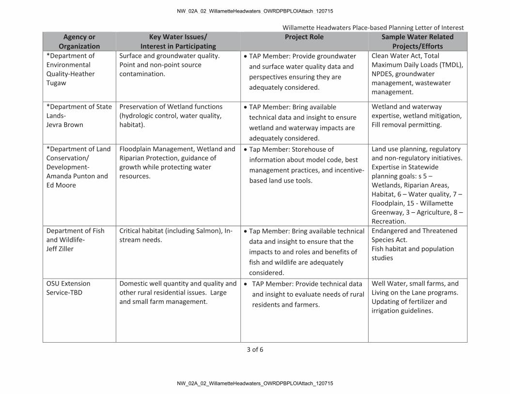
*Department of Environmental Quality-Heather Tugaw
Surface and groundwater quality. Point and non-point source contamination.
TAP Member: Provide groundwater and surface water quality data and perspectives ensuring they are adequately considered.
Clean Water Act, Total Maximum Daily Loads (TMDL), NPDES, groundwater management, wastewater management.
*Department of State Lands- Jevra Brown
Preservation of Wetland functions (hydrologic control, water quality, habitat).
TAP Member: Bring available technical data and insight to ensure wetland and waterway impacts are adequately considered.
Wetland and waterway expertise, wetland mitigation, Fill removal permitting.
*Department of Land Conservation/ Development-Amanda Punton and Ed Moore
Floodplain Management, Wetland and Riparian Protection, guidance of growth while protecting water resources.
Tap Member: Storehouse of information about model code, best management practices, and incentive-based land use tools.
Land use planning, regulatory and non-regulatory initiatives. Expertise in Statewide planning goals: s 5 – Wetlands, Riparian Areas, Habitat, 6 – Water quality, 7 – Floodplain, 15 - Willamette Greenway, 3 – Agriculture, 8 – Recreation.
Department of Fish and Wildlife- Jeff Ziller
Critical habitat (including Salmon), In-stream needs.
Tap Member: Bring available technical data and insight to ensure that the impacts to and roles and benefits of fish and wildlife are adequately considered.
Endangered and Threatened Species Act. Fish habitat and population studies
OSU Extension Service-TBD
Domestic well quantity and quality and other rural residential issues. Large and small farm management.
TAP Member: Provide technical data and insight to evaluate needs of rural residents and farmers.
Well Water, small farms, and Living on the Lane programs. Updating of fertilizer and irrigation guidelines.
NW_02A_02_WillametteHeadwaters_OWRDPBPLOIAttach_120715
NW_02A_02_WillametteHeadwaters_OWRDPBPLOIAttach_120715

Willamette Headwaters Place-based Planning Letter of Interest
4 of 6
Agency or Organization
Key Water Issues/ Interest in Participating
Project Role Sample Water Related Projects/Efforts
Municipality *Small Cities (Creswell, Cottage Grove, Oakridge, Westfir, Lowell)- Public Works Directors and/or City Administrators
Quality (blue green algae, TMDLs, , ESA, etc.,). Integration of new FEMA regulations. Groundwater arsenic and nitrate issues. Drinking water source areas outside of jurisdiction authority. Insufficient supply during summer months (Westfir, Oakridge) Insufficient water supply for high use industry (Creswell).
Representation on Stakeholder Committee. Sharing of local data and individual jurisdiction needs.
Wastewater, stormwater, local Goal 5 programs, wetland inventories.
Metro Area cities *Springfield-Todd Miller and *Eugene-Therese Walch)
Treatment, re-use, conservation and preservation
Representation on Stakeholder Committee. Bring Metro Area specific needs and interests to the table.
Wastewater, stormwater, local Goal 5 program, wetland inventories.
Lane County-TBD Quality (blue green algae, TMDLs, , ESA, etc.,) Integration of new FEMA regulations Groundwater arsenic and nitrate issues. Small public water system needs and issues.
Representation on TAP and Stakeholder Committee. Share data on potential pollutant sources and projected demand based on population and industry.
Goal 5, 6 and 7 programs, Drinking water and domestic well program, septic permit and inspection.
Utilities *Eugene Water & Electric Board-Karl Morgenstern & Brad Taylor and *Springfield Utility Board-Amy Chinitz,
Water quality and quantity-provision of safe drinking water to customers.
Representation on TAP and Stakeholder Committee. Integrate interests of Metro area drinking water providers into the process.
Water Provision, Source Protection, Treatment. Volunteer Incentives Program. State approved drinking water protection plans.
NW_02A_02_WillametteHeadwaters_OWRDPBPLOIAttach_120715
NW_02A_02_WillametteHeadwaters_OWRDPBPLOIAttach_120715

Willamette Headwaters Place-based Planning Letter of Interest
5 of 6
Agency or Organization
Key Water Issues/ Interest in Participating
Project Role Sample Water Related Projects/Efforts
*Metro Wastewater Management Commission-Todd Miller
Potential to integrate water re-use in an overall water management plan.
Integrate interests of Metro area wastewater.
Exploring potential for water re-use and wastewater temperature control.
Watershed Councils McKenzie- Larry Six, *Coast Fork-Amanda Wilson, and Middle Fork-Sarah Dyrdahl
Watershed scale water quality and quantity. Work with interested land owners
Representation on TAP and Stakeholder Committee. Compilation of watershed specific available data. Outreach and education.
Watershed assessments and Action Plans Restoration, connection to variety of landowners (agriculture, timber, residential, etc.).
Other Organizations *Cascade Pacific Resource Conservation and Development- David Richey
Explore social, economic, educational, and environmental improvements to the region.
Representation on TAP Compilation of watershed specific available data. Outreach.
Forest Stewardship, Wildlife Habitat Restoration, Fiscal Sponsorship, Invasive Species Management. Local government support.
Oregon Environmental Council- Samantha Murray
A nonprofit, non-partisan, organization working to protect clean water, a healthy climate, an unpolluted landscape and sustainable food and farms.
• Potential TAP member Provide information on cumulative
impacts. Provide an “environmental group”
perspective that respects other interests.
Climate Change Business Coalition, Toxic Free Kids Act, River Cleanup, green infrastructure.
*Oregon Freshwater Simulations- David Conklin
Interest in applying the Willamette 2100 Project data to a region specific context.
• Segregate headwaters region specific data that was generated for the Willamette 2100 Project.
Modeler for the Willamette 2100 Project and others.
NW_02A_02_WillametteHeadwaters_OWRDPBPLOIAttach_120715
NW_02A_02_WillametteHeadwaters_OWRDPBPLOIAttach_120715
Willamette Headwaters Place-based Planning Letter of Interest
6 of 6
Agency or Organization
Key Water Issues/ Interest in Participating
Project Role Sample Water Related Projects/Efforts
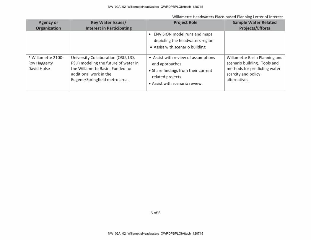
ENVISION model runs and maps depicting the headwaters region
Assist with scenario building
* Willamette 2100-Roy Haggerty David Hulse
University Collaboration (OSU, UO, PSU) modeling the future of water in the Willamette Basin. Funded for additional work in the Eugene/Springfield metro area.
• Assist with review of assumptions and approaches. Share findings from their current related projects. Assist with scenario review.
Willamette Basin Planning and scenario building. Tools and methods for predicting water scarcity and policy alternatives.
NW_02A_02_WillametteHeadwaters_OWRDPBPLOIAttach_120715
NW_02A_02_WillametteHeadwaters_OWRDPBPLOIAttach_120715

Willamette Headwaters Place-based Planning Letter of Interest
1 of 4
Attachment 3 Detailed Scope of Work and Products
Scope of Work The approach is based on Oregon Water Resources Department’s five Planning Steps:
Planning Step 1: Build collaborative process with all interested parties in the headwaters region of the Willamette Basin
a. Refine the planning scale (geographic and programmatic). Identify additional groups or focus areas to broaden and/or deepen engagement. Confirm partner and stakeholder interest.
b. Convene and initiate a process with a representation of interests and meaningful public involvement.
i. Form a Stakeholder Committee to represent and engage a full range of stakeholders through quarterly meetings (Industry, municipalities, agriculture, forestry, reservoirs, residential, etc.).
ii. Build relationships and identify common purposes. iii. Form and meet with a Technical Advisory Pool (TAP) including State and
Federal agency staff, to draw technical and organizational insight throughout the project.
iv. Working with the WRD refine forums of stakeholders, partners, and other interested parties.
v. Form and meet with working groups to explore water resource issues of common interests to initiate ideas and recommendations to bring to the broader stakeholder forum. These could include a metro area, small cities, forestry, or agriculture working group.
c. Refine a work plan working toward the common purpose of maintaining healthy water resources, considering economic, environmental, and social needs for the region in the near and long term.
Planning Step 2: Characterize current water resources and identify challenges, gaps, and opportunities.
a. Describe and assess current water quantity and quality, and the status of ecosystem health to determine challenges, gaps, and opportunities.
i. Include ground and surface water resource demand, supply, and quality issues.
ii. Characterize how water is used/shared. iii. Assess and characterize the regulatory overlay/framework. iv. Reference federal and state programs (e.g. TMDLs plans, water re-
allocations studies, NPDES). v. Characterize connections, gaps and opportunities of cross-programs.
benefits for state, federal, and local water resource regulatory framework.
vi. Consider ecological issues such as floodplain and other habitat.
NW_02A_02_WillametteHeadwaters_OWRDPBPLOIAttach_120715
NW_02A_02_WillametteHeadwaters_OWRDPBPLOIAttach_120715

Willamette Headwaters Place-based Planning Letter of Interest
2 of 4
vii. Identify and assess the “hot spots” in the urban and rural landscapes what’s working well/good outreach programs etc.
b. Develop a “cross-walk” matrix and maps of agency programs and identify opportunities in meeting overlapping program requirements (ESA, TMDLs, floodplain, drinking water, etc.). For example, by protecting wetlands that have a thermoregulation function, cities can demonstrate that they are taking actions to meet the temperature TMDL allocation.
c. Coordinate with Oregon Freshwater Simulations Company to obtain headwaters region specific data and mapping originating from the Willamette 2100 Project.
d. Working with stakeholders, identify challenges, gaps, and potential opportunities.
e. Provide and discuss a repository of existing information to improve coordination and efficiency in expanding understanding of water resource dynamics.
f. Develop a project website to: a. Present regional water characterization information. b. Provide a central location for future project file sharing and coordination
(from Planning Steps 1 through 5). c. Effectively communicate project process, findings and plans.
Planning Step 3: Quantify instream and out of stream need, and account for coming pressure.
a. Describe the relationship between current water demand and supply. b. Identify the relationship between future (25-50 years) water demand and supply. c. Incorporate the research and findings of the Willamette Basin Review-Reservoir
Study and coordinate with Oregon Freshwater Simulations Company to run the ENVISION model for data characterization and scenario building.
d. Consider meeting water needs within the context of the region, accounting for the hydrological, geological, biological, climatic, socio-economic, cultural, legal, and political conditions of the region.
e. Evaluate and describe the balance of water quality/supply/ecosystem drivers. Assess elements of high vulnerability to decreased water quality and quantity.
f. Envision and create 4-5 potential future scenarios (including the existing use) depicting watershed management approaches.
g. Generate a scenario report including maps and analysis.
Planning Step 4: Develop solutions for meeting near term and long term needs. a. Hold meetings, work sessions and/or open houses to collaboratively develop
integrated solutions and a shared vision. b. Recommend a suite of actions and/or alternatives to address the region’s water-
related challenges with the goal of meeting both instream and out-of-stream needs.
i. Identify strategies and regionally beneficial projects, including priorities for implementation actions as well as lead agency roles and responsibilities for each action.
NW_02A_02_WillametteHeadwaters_OWRDPBPLOIAttach_120715
NW_02A_02_WillametteHeadwaters_OWRDPBPLOIAttach_120715

Willamette Headwaters Place-based Planning Letter of Interest
3 of 4
ii. Identify strategies that allow the region to successfully prevent, mitigate, or adapt to water scarcity.
a. Modeling the system; explain interactions among hydrologic, ecological, and socioeconomic dimensions; identifying vulnerabilities; compare alternatives; and transfer to other regions.
iii. Identify and highlight strategies with multiple program benefits (TMDLS, groundwater recharge, floodplain, drinking water, habitat, etc.).
iv. Incorporate funding mechanisms. v. Combine strategies of built and natural infrastructure (dams, wetlands,
upland recharge, land management). vi. Integrate rural and urban water management and water quality goals.
Planning Step 5: Create an integrated water resource plan considering water supply issues (quantity and quality). Strive for a plan identifying better water quality, wiser use, and increasing floodplain/storm storage to meet/exceed regulatory requirements and increase resiliency to climate change.
a. Develop a formal Integrated Water Resources Plan that can serve as a model/template for other place- based planning efforts, including:
i. Goals, objectives, strategies/projects. ii. An alternatives analysis (methodology in support of the plan ensuring
feasibility and coordination before making large investments.) iii. Clearly outlined roles, responsibilities and priorities. iv. An action plan for outreach and dissemination.
b. Circulate plan before governing bodies for plan agreement. c. Produce an evaluation/report on the successes and challenges in conducting
place-based planning. i. Demonstration of the local and state-wide benefits of investing in
place-based water planning efforts. ii. Identification of and strategies to address factors that enable or
constrain place-based water resource planning. iii. Highlighting tools and processes that best support place-based efforts.
Work Products Core products for the five steps include the following:
A refined work plan representing the broad support and common purpose of stakeholders and partners.
Project website (project information, project coordination, regional water data, outreach).
Willamette Headwaters Current Water Supply, Demand and Quality Characterization Report (including maps and analysis).
Willamette Headwaters Forecasted Water Supply, Demand and Quality Characterization Report (including 4-5 modeled future scenarios with maps and analysis).
NW_02A_02_WillametteHeadwaters_OWRDPBPLOIAttach_120715
NW_02A_02_WillametteHeadwaters_OWRDPBPLOIAttach_120715

Willamette Headwaters Place-based Planning Letter of Interest
4 of 4
Crosswalk matrix of integrated agency water related programs, regulations and opportunities.
10-16 collaborative group meetings (full stakeholder group and/or working groups). At least 3 work-sessions and/or open houses for broader stakeholder feedback/vetting. Willamette Headwaters Water Action/Alternatives Recommendation Report. Willamette Headwaters Integrated Water Resource Plan. Willamette Headwaters Integrated Water Resources Plan Process Summary and
Evaluation Report.
Quarter Work Products Schedule by Quarter 1 2 3 4 5 6 7 8 9 10 A refined work plan representing the broad support and common purpose of stakeholders and partners.
Project website (project information, project coordination, regional water data, outreach).
Willamette Headwaters Current Water Supply, Demand and Quality Characterization Report (including maps and analysis). Willamette Headwaters Forecasted Water Supply, Demand and Quality Characterization Report (including 4-5 modeled future scenarios with maps and analysis). Crosswalk matrix of integrated agency water related programs, regulations and opportunities.
10-16 collaborative group meetings (full stakeholder group and/or working groups).
At least 3 work-sessions and/or open houses for broader stakeholder feedback/vetting.
Willamette Headwaters Water Action/Alternatives Recommendation Report.
Willamette Headwaters Integrated Water Resource Plan.
Willamette Headwaters Integrated Water Resources Plan Process Summary and Evaluation Report.
NW_02A_02_WillametteHeadwaters_OWRDPBPLOIAttach_120715
NW_02A_02_WillametteHeadwaters_OWRDPBPLOIAttach_120715

Willamette Headwaters Place-based Planning Letter of Interest
1 of 3
Attachment 4 Regional Water Resource Projects,
Description, Timeframes, Funding Amount Project: “Integrating the Retooling of Oregon Wetland Rapid Assessment Protocol (ORWAP) into the Planning Process” Timeframe: 2013-2017 Grant Funding: $208,000 from DLCD and EPA Description: This project informs the “retooling” of a new state authorized wetland assessment method for local wetland inventories. The outcomes of the assessment tool must meet the needs of local jurisdictions and support the work of multiple resource management agencies by providing “cross program” analysis within the assessment tool. Project deliverables include a planning guide for local jurisdictions, rulemaking assistance, tool outputs designed to meet multiple program objectives (ESA, floodplain, TMDLs, etc.) and analysis of climate change influences on wetlands and water resource planning. Project: “Southern Willamette Valley Groundwater Management Area (GWMA) Groundwater Quality Improvement and Protection” Timeframe: 2003-2017 Grant Funding: $410,000 from DEQ and EPA Description: LCOG has been a lead partner in the 230 square mile, three-county, five-city Southern Willamette GWMA. LCOGs role has included extensive public and public official outreach to heighten awareness of and encourage actions towards reducing a nitrate contamination problem in groundwater. For the past 12 years, we have coordinated a 15-member state appointed stakeholder Committee of farmers, residents, business owners, environmental interests, and public officials. The Committee developed and LCOG wrote a voluntary based Action Plan to address contamination issues. LCOG and about 12 state and local agencies help to implement the Action Plan bringing safe drinking water to the households and businesses in the area. Project: “Multi-City/County Water Resource Assessment Project (MCWRAP) Phase III” Timeframe: 2011-2015 Grant Funding: $186,000 from EPA and DLCD Description: This project supported policy development for wetland and riparian protection for four small cities in four counties. It tested and evaluated multiple distinct public and public official processes to determine the effectiveness of different types of outreach mechanisms. The project successfully managed the needs and missions of numerous agencies, jurisdictions and stakeholders. Cross-program maps and analysis provided each city with the tools to integrate multiple water resource programs into policy decisions. This project was nominated for the American Water Resources Association Integrated Water Resource Management Award.
NW_02A_02_WillametteHeadwaters_OWRDPBPLOIAttach_120715
NW_02A_02_WillametteHeadwaters_OWRDPBPLOIAttach_120715

Willamette Headwaters Place-based Planning Letter of Interest
2 of 3
Program/Project: McKenzie Volunteer Incentives Program (VIP) Timeframe: 2012-present Funding: $275,000 (LCOG portion of funding) Description: To protect and preserve water quality in the McKenzie Watershed, the Eugene Water and Electric Board (EWEB) has developed a Payment for Ecosystem Services Voluntary Incentives program. The program is designed to preserve high-quality riparian vegetation in the by remunerating landowners for keeping their high-quality vegetation stands intact under a protection pathway. Landowners whose lands do not qualify for protection are directed towards restoration to bring the lands they manage into a condition which would qualify them for protection. The program is supported through coordination with various government agency restoration efforts and a business incentive program. LCOG is the lead partner in spatial technologies, data management, and landscape analysis. Project: “Willamette Headwaters Regional Water Resource Protection (MCWRAP Phases I & II)” Timeframe: 2009-2012 Grant Funding: $522,000 from EPA and DLCD Description: LCOG coordinated the work of eight cities within Lane, Linn, Marion, and Benton Counties to inventory, assess, and protect significant water resources in order to guide growth in cities in the Valley. LCOG worked with a multi-jurisdictional group comprised of each local jurisdiction and supported by a range of state and federal agencies such as the DSL, DLCD, DEQ, and EPA. A core concept maintained that all jurisdictions work together as a team yet have a great deal of flexibility for individual jurisdiction needs and desires. The project has resulted in local cities knowing more exactly where wetland resources are and whether or not those resources serve important functions such as flood control, groundwater recharge, and meeting regulatory obligations (TMDLs, ESA, FEMA etc.). Several deliverables serve as templates and tools for other cities in the state. Project: “Water Conservation and Reuse Planning Study” Timeframe: 2011-2013 Grant Funding: $50,000 from WRD Description: This project ignited a conservation and reuse initiative for small cities in the upper region of the Willamette River Basin. Through an examination of information about current supply and future demand needs, LCOG worked with two cities to develop water conservation and reuse policies that include existing and successful models to reduce water supply needs. This pilot project of two cities initiated a regional platform for water conservation/reuse and provided feedback from stakeholders throughout the process. Strategies developed served as models for other cities, Project: “Lane and Benton County Public Water System Land Use Website and Notification Tool” Timeframe: 2010-2011 Grant Funding: $50,000 from OHA Description: In partnership with the Springfield Utility Board, and Benton and Lane Counties,
NW_02A_02_WillametteHeadwaters_OWRDPBPLOIAttach_120715
NW_02A_02_WillametteHeadwaters_OWRDPBPLOIAttach_120715

Willamette Headwaters Place-based Planning Letter of Interest
3 of 3
LCOG completed a Public Water System Land Use Website and Notification Tool for Lane and Benton Counties. The tool provides surface and groundwater public water systems with notice of specific land use actions that occur within their systems, making all systems more aware of potential impacts. It offers an opportunity for water systems to influence land use decisions by providing insight into the applicable land use approval criteria outlined in the notice. Project: “Lane Regional Total Maximum Daily Load (TMDL) Planning Timeframe: 2006-2009 Grant Funding: $189,000 from DEQ and EPA Description: LCOG coordinated a regional TMDL planning initiative for the nine local jurisdictions in the Lane County portion of the Willamette Basin. We worked with local utility companies, four watershed councils and eight cities and the county to establish TMDL Implementation Plans meeting TMDL requirements. We developed tools and processes such as conducting a gaps analysis, and developing a matrix to reduce listed parameters. The work focused on the coordination of the Designated Management Agency efforts in the region and the development of a regional study and jurisdiction-specific TMDL Implementation Plans. The tools and plans produced provided models and templates for other cities and counties throughout the Basin. Project: “Eugene-Springfield Metro Waterways Project.” Timeframe: 2003-2012 Funding: $385,000 from ACOE, Springfield, Eugene, and Lane County Description: The purpose of the Eugene-Springfield Metropolitan Waterways Project was to evaluate opportunities to develop comprehensive water resource improvement projects in four watersheds with benefits for multiple water resource objectives. These objectives include flood damage reduction, aquatic ecosystem restoration, water quality improvement, public use, waterway improvements and integrated watershed management. LCOG directed a collaborative process to perform a feasibility study to develop comprehensive watershed analysis and develop multiple-objective improvements throughout the Eugene-Springfield metropolitan waterways region. Project: “Rivers to Ridges” Timeframe: 2002 Funding: $60,000 from partner agencies (Eugene, Springfield, Lane County, BLM) Description: This project brought a regional perspective to parks and open space planning for the Eugene-Springfield Metropolitan Area. Prior to the project, parks and open space planning had been occurring primarily at a local level without the benefit of consideration of regional needs. The process and products included a single comprehensive vision for the metropolitan region as a whole resulting in identifying priorities, funding opportunities and increased and ongoing local multijurisdictional coordination.
NW_02A_02_WillametteHeadwaters_OWRDPBPLOIAttach_120715
NW_02A_02_WillametteHeadwaters_OWRDPBPLOIAttach_120715

Attachment 5 - Detailed Budget Willamette Headwaters Place-based Planning Letter of Interest
Planning Tasks and Activities
Term months 1-30 LCOG
Watershed Councils
Oregon Freshwater Simulations
Total Request Match
Project Total
1. Build collaborative process with all interested parties ongoinga. Refine the planning scale, identify additional interests, and confirm partner and stakeholder interest 1-3 4,400 240 4,640 8,000 12,640 b. Convene and initiate a process with a representation of interests and meaningful public involvement - - i. Engage range of stakeholders through quarterly meetings. 3-27 12,000 1,000 13,000 9,600 22,600 ii. Build relationships and identify common purposes 3-27 9,600 800 10,400 10,400 iii. Form and meet with a technical advisory pool 3-27 9,600 9,600 8,000 17,600 iv. Form and meet with working groups 4-27 15,000 4,000 19,000 16,000 35,000 c. Refine a work plan designed to reach common purposes 3-6 6,000 6,000 3,600 9,600 2. Characterize current water resources and identify challenges, gaps, and opportunities. 4-30 - - a. Assess water quantity and quality, and status of ecosystem health to determine challenges, gaps, and opportunities. - -
i. Include ground and surface water demand, supply, and quality issues. 4-10 10,000 10,000 1,280 11,280 ii. Characterize how water is used/shared 6 2,000 2,000 1,280 3,280 iii. Assess and characterize the regulatory framework 7-9 1,000 1,000 2,560 3,560 iv. Reference federal and state programs 7-9 2,000 2,000 2,000 v. Characterize cross program benefits for regulatory framework 9-10 1,500 1,500 1,500 vi. Identify and assess the “hot spots” in the urban and rural landscapes what’s working well. 8-10 6,000 360 6,360 2,880 9,240 vii. Include considerations of ecological issues 9-12 8,000 8,000 3,200 11,200 b. Develop a “cross-walk” matrix and maps of programs and opportunities to meet overlapping requirements. 10-11 5,000 300 5,300 8,000 13,300 c. Coordinate with OR Freshwater Simulations Company for region specific Willamette 2100 data 4,000 4,000 4,000 d. Provide and discuss a repository of existing information 12-27 8,000 8,000 8,000
e. Facilitate identification of challenges, gaps, and potential opportunities. 4-18 12,000 500 12,500 6,720 19,220 f. Develop a project web site 4-30 13,000 13,000 13,000 3. Quantify instream and out of stream need, accounting for coming pressure 12-26 - - a. Describe relationship between current water demand and supply. 12-16 6,000 6,000 1,600 7,600
1 of 2
NW_02A_02_WillametteHeadwaters_OWRDPBPLOIAttach_120715
NW_02A_02_WillametteHeadwaters_OWRDPBPLOIAttach_120715

Attachment 5 - Detailed Budget Willamette Headwaters Place-based Planning Letter of Interest
Planning Tasks and Activities
Term months 1-30 LCOG
Watershed Councils
Oregon Freshwater Simulations
Total Request Match
Project Total
b. Portray the relationship between future (25-50 years) water demand and supply. 12-16 4,800 4,800 1,600 6,400 c. Incorporate the research and findings of the Willamette Basin Review and coordinate with Oregon Freshwater Simulations to run ENVISION Model scenarios for the region. 16 3,600 5,000 8,600 2,400 11,000 d. Consider meeting water needs within the context of the region. 18-21 9,000 9,000 4,000 13,000 e. Evaluate balance of water quality/supply/ecosystem drivers. Assess vulnerabilities. 18-21 7,200 7,200 7,200 f. Create future scenarios depicting approach options. 21-26 9,600 9,600 2,400 12,000 g. Generate a scenario report including maps and analysis. 23-26 9,000 9,000 9,000 4. Develop solutions for meeting near term and long term needs 18-27 - - a. Hold meetings, work sessions and/or open houses 24-27 9,600 3,000 12,600 2,400 15,000 b. Recommend a suite of actions and/or alternatives to address the community’s water-related challenges. 18-26 - - i. Identify strategies, projects, and priorities. 20 9,600 9,600 9,600 ii. Identify strategies to allow the region to prevent mitigate, or adapt to water scarcity 21 4,800 4,800 4,800 iii. Highlight strategies with multiple program benefits 21 4,800 4,800 1,200 6,000 iv. Incorporate funding mechanisms 22 4,800 4,800 4,800 v. Combine strategies of built and natural infrastructure. 22 4,800 4,800 800 5,600
vi. Integrate urban and rural water management and water quality goals. 22-23 4,800 4,800 7,200 12,000 5. Create an integrated water resource plan. 24-30 - - a. Develop a Plan that serves as a model/template: - - i. Goals, objectives, strategies/projects 24 3,000 3,000 800 3,800 ii. An alternatives analysis 25 8,500 8,500 8,500 iii. Roles, responsibilities, and priorities 26 3,000 3,000 3,000 iv. Action plan for outreach and dissemination 24-27 5,200 5,200 5,200 b. Circulate plan before governing bodies. 27-30 4,800 4,800 3,600 8,400 c. Produce a place-based planning evaluation/report. 24-30 - - i. Demonstration of benefits. 24-28 2,000 2,000 6,000 8,000 ii. Factors that enable or constrain place based planning. 24-30 3,200 3,200 3,200 iii. Support tools and processes 26-30 3,000 3,000 3,000 Total 250,200 10,200 9,000 269,400 105,120 374,520
2 of 2
NW_02A_02_WillametteHeadwaters_OWRDPBPLOIAttach_120715
NW_02A_02_WillametteHeadwaters_OWRDPBPLOIAttach_120715