WILD AND SCENIC RIVERS - University of Minnesota
3
WILD AND SCENIC RIVERS An unspoiled river is a very rare thing in this Nation today. Their flow and vitality have been harnessed by dams and too often they have been turned into open sewers by communities and by industries. It makes us all very fearful that all rivers will go this way unless somebody acts now to try to balance our river development. President Lyndon Johnson’s remarks on signing the Wild & Scenic Rivers Act, October 2, 1968 Wildness vs. control, beauty vs. profitability, serenity vs. industry .... Fifty years ago Americans questioned the balance of recreation and development along national waterways. Decades of pollution, diversion, and construction threatened the health of America’s rivers. Outdoor enthusiasts pressed congress into action, creating the Wild and Scenic Rivers Act, signed by President Lyndon B. Johnson in 1968. Minnestoans took the lead, motivated by a desire to preserve the St. Croix River. Senator Walter Mondale and Representative Joe Karth collaborated with Wisconsin senator and founder of Earth Day, Gaylord Nelson, to craft the legislation and ensure its passage. Twenty year later, Minnesota Representative Bruce Vento presided over a major expansion of the Act to protect additional rivers. Curator: Elisabeth DeGrenier Graphic Designer: Melissa Bartz Minnesota Senator Walter Mondale receiving the pen President Johnson used to sign the Wild and Scenic Rivers Act. Courtesy Minnesota Historical Society.
Transcript of WILD AND SCENIC RIVERS - University of Minnesota

WILD AND SCENIC RIVERSAn unspoiled river is a very rare thing in this Nation today. Their flow and vitality have been harnessed by dams and too often they have been turned into open sewers by communities and by industries. It makes us all very fearful that all rivers will go this way unless somebody acts now to try to balance our river development.
President Lyndon Johnson’s remarks on signing the Wild & Scenic Rivers Act, October 2, 1968
Wildness vs. control, beauty vs. profitability,
serenity vs. industry.... Fifty years ago
Americans questioned the balance of
recreation and development along national
waterways. Decades of pollution, diversion,
and construction threatened the health of
America’s rivers. Outdoor enthusiasts
pressed congress into action, creating the
Wild and Scenic Rivers Act, signed by
President Lyndon B. Johnson in 1968.
Minnestoans took the lead, motivated by
a desire to preserve the St. Croix River.
Senator Walter Mondale and Representative
Joe Karth collaborated with Wisconsin senator
and founder of Earth Day, Gaylord Nelson, to
craft the legislation and ensure its passage.
Twenty year later, Minnesota Representative
Bruce Vento presided over a major expansion
of the Act to protect additional rivers.
Curator: Elisabeth DeGrenier
Graphic Designer: Melissa Bartz
Minnesota Senator Walter Mondale receiving the pen President Johnson used to sign the Wild and Scenic Rivers Act. Courtesy Minnesota Historical Society.
WILD AND SCENIC:PURPOSE AND NEEDWhat makes a river worthy of national designation
as “wild and scenic?” Three criteria must be met
to ensure the river:
1) is free-flowing, unimpeded by dams;
2) possess one or more “outstandingly
remarkable values:” natural, scenic,
educational, geological, recreational, historic,
fish and wildlife, scientific and cultural; and
3) is protected by local, state, or federal laws
that preserve the values that made it eligible
for designation.
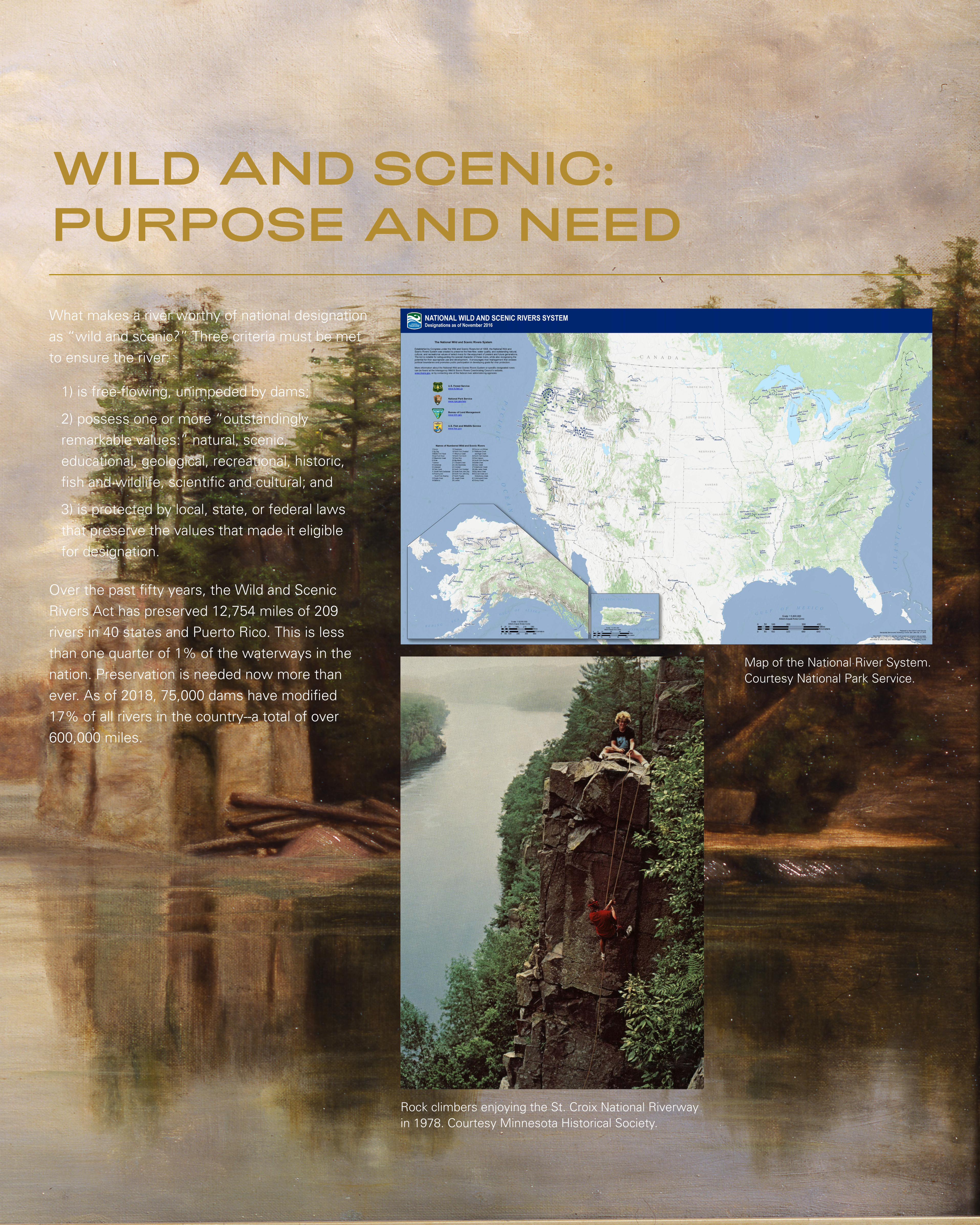
Over the past fifty years, the Wild and Scenic
Rivers Act has preserved 12,754 miles of 209
rivers in 40 states and Puerto Rico. This is less
than one quarter of 1% of the waterways in the
nation. Preservation is needed now more than
ever. As of 2018, 75,000 dams have modified
17% of all rivers in the country--a total of over
600,000 miles.
Rock climbers enjoying the St. Croix National Riverway in 1978. Courtesy Minnesota Historical Society.
Map of the National River System. Courtesy National Park Service.
Zebra Mussel Access Control PointNo upstream travel past High Bridge(river mile 29.5)
Rapids below dam require1.25-mile portage
See Map 2
See Map 3
See Map 7
See Map 8
See Map 9
See Map 10
See Map 4
See Map 1
See Map 5
See Map 6
Lock andDam No. 2
Hydroelectric dam
CoppermineDam
GordonDam
TregoDam
NamekagonDam
Pacwawong Dam
Hayward Dam
Phipps Dam
MINNESOTA
WISCONSIN
W I S C O N S I N
M I N N E S O T A
Upp
er
Tam
arac
k R
iver
Lo
wer T
amar
ack
Rive
r
UpperSt. Croix Lake
MinongFlowage
PearLake
Totogatic
River
GullLake
Lac CourteOreilles
Grindstone Lake Chippewa
Flowage
Round Lake
NelsonLake
LakeOwen
Upper Eau ClaireLake
LowerEau Claire
Lake
MiddleEau Claire
Lake
Ket
tle
Riv
er
Snake River
Wood River
WoodLake
SpiritLake
ClamFlowage
Clam River
LittleYellow
LakeYellowLake Devils
Lake
BassLake
ClamLake
Big SandLake
SandLake
BirchIslandLake
McKenzieLake
Spooner Lake
ShellLake
BearLake
Red Cedar River
Rush River
Eau Galle River
Hay R
iver
BigRoundLake
BoneLake
Sun
rise
Riv
er
SunriseLake
Trade
River
Goose Cre
ek
Rush Creek
Rush Lake
Pokegama Lake
Snake River Snake Rive
r
Rum
River
ChisagoLake
BigMarine
Lake
CedarLake
Wapogasset Lake
TainterLake
LakeMenomin
LakeWisota
Apple R
BaldEagleLake
WhiteBearLake
LakeElmo
SquareLake
Kinnickinnic River
Spring Lake
LakePepin
Yello
w R
iver
Tri
mb
elle
Rive
r
Mississippi River
NamekagonLake
St. CroixFlowage
Big FishTrap Rapids
St. Cro
ix River
St. C
roix River
St. Croix River
Nam
ekag
on
Mississ ippi River
Trego Lake
Phipps Flowage
Indian Head Flowage
Pacwawong Flowage
Hayward Lake
River
NA
ME
KA
GO
NR I V E R
ST. C
RO
I X R I V E R
Source of theSt. Croix River
STATE ZONE
FEDERAL ZONE
150
140
10
20
30
40
50 60
70
80
90
130
120
110
100
90
80
70
60
50
40
30
20
10
10
Dairyland
CozyCorner
Gordon
Minong
SolonSprings
HAYWARD
Seeley
Cable
TregoEarl
Springbrook
Cumberland
TURTLE LAKE
BALSAMLAKE
Cushing
Milltown
ST. CROIX FALLS
OSCEOLA
Chisago City CenterCity
Lindstrom
Star Prairie
Hammond
TAYLORS FALLS
Almelund
Sunrise
NORTH BRANCH
Rush City
CAMBRIDGE
PRINCETON
Hinckley
Grantsburg
Pine City
MORA
SPOONER
SIREN
Cloverdale
WebbLake
Danbury
FREDERICTrade River
Luck
NEW RICHMOND
MARINE ON ST. CROIX
Copas
Somerset
Houlton
STILLWATER
BAYPORT
HUDSONLAKELAND
LAKE ST.CROIX BEACH
AFTON
RIVER FALLS
ST. PAUL
HASTINGS
PRESCOTT
PointDouglas
MINNEAPOLIS
ANOKA
FORESTLAKE
Wyoming
Shell Lake
Hertel
WebsterCREX MEADOWSWILDLIFE
AREA
FISH LAKEWILDLIFE AREA
ST. CROIXISLANDSWILDLIFEAREA
ST. CROIXSTATE FOREST
CHENGWATANASTATE FOREST
GOVERNOR KNOWLESSTATE FOREST
GOVERNORKNOWLESSTATE FOREST
CHEQUAMEGON-
NICOLET
NATIONAL
FOREST
ST. CROIXSTATE PARK
WILD RIVERSTATE PARK
WISCONSIN INTERSTATE STATE PARK
MINNESOTA INTERSTATESTATE PARK
WILLIAM O’BRIEN STATE PARK
WILLOW RIVERSTATE PARK
AFTONSTATEPARK
KINNICKINNICSTATE PARKST. CROIX BLUFFS
REGIONAL PARK
Great River Road Visitor Center
Hayward Beach
Cable Natural History Museum
Historic portage routeto Bois Brule River
The Dalles of the St. Croix
High Bridge
St. CroixScenicByway
St. C
roix
Sce
nic
Byw
ay
MISSISSIPPI NATIONAL RIVERAND RECREATION AREA
MISSISSIPPINATIONAL RIVERAND RECREATION
AREA
Namekagon-Lac CourteOreilles Portage Trailhead
Trego Lake Trailhead
Indian Head Flowage Trailhead
Ridge ViewTrailhead
Trego NatureTrailhead
Spanglers
Ice Age National Scenic Trailhead
St. CroixTrailhead
St. Croix Trailhead
STATE ZONEThis part of the St. CroixNational Scenic Riverwayis managed by the states ofMinnesota and Wisconsin.
Sandrock CliffsSandrock Cliffs Trailhead
Cable Waysideand Landing
Thompson Bridge Landing
Eagle’s Landing
Trego TownPark Landing
Trego Landing
Gordon DamCounty Park Landing
Louise Park Landing
Schoen Park Landing
Lions Park Landing
Lions Park Landing
Franconia Landing
Raspberry Landing
Log HouseLanding
Pacwawong FlowageLanding
Main CanoeLanding
Head of the Rapids Landing
Sand CreekLanding
Wild RiverLanding
Sunrise River Landing
Little YellowBanks Landing
West River Landing
St. Croix BoomSite Park Landing
Hayward Landing
West HowellLanding
Dry Landing
CCC Bridge Landing
StinnettLanding
County Road KLanding
NorthSpringbrookLanding
Big Bend Landing
SpringbrookLanding
County Road MLanding
Phillipi Bridge Landing
PhippsLanding
Howell Landing
Earl Park Landing
Groat Landing
McDowell Bridge Landing
Namekagon DamLanding
Cap Creek Landing
Whispering PinesLanding
Nevers Dam Landing
Osceola Landing
Old Railroad Bridge Landing
Stevens Creek Landing
County Road O LandingRush CityFerry Landing
Sunrise Ferry Landing
Highway 70 Wayside Landing
Highway 70 Landing
Norway Point Landing
Soderbeck Landing
Snake River Landing
FritzLanding
NamekagonTrail Landing
Riverside Landing
Fox Landing
Somerset Landing
Larsen Landing
Trout Run Landing
County Road T Landing
Nelsons Landing
ThayersLanding
Lower Tamarack Landing
ST. CROIX NATIONALSCENIC RIVERWAY
Some land along the Riverwayremains in private ownership.Please respect landownersand their property.
St. Croix NationalScenic Riverway
Rapids River mileage
River distances are shownevery 10 miles (16 kilometers).The St. Croix River is measuredfrom the Mississippi River. TheNamekagon River is measuredfrom the St. Croix River.
St. Croix ScenicByway
State and regionalparks
U.S. and stateforests
State wildife areas
Mississippi NationalRiver and RecreationArea
Managed by:Facility type:
Map symbols
Ranger station
Information
Primitive shorelinecampsite
Boat and canoe launch
Canoe launch
Fishing pier
National Park Service
State park or state-owned area
U.S. and state forest
State wildlife area
County, city, or privatePicnic area
Developed campground
Do not use this map for river navigation. Get detailed river section maps (see top left, first paragraph), which are essential to your River- way recreation. The gray boxes above show the coverage of each river section map.
0
0
5 10 Kilometers
5 10 Miles
North
F
F
F
F
U
M
D
AE
A
A
N
Y
Y
M
T
T
I
I
53
63
M
D
211
63
F
F
H F
K
35
22
30
24
25
53
63
8
53
53
63
S
G
0
05
3
8
16
81
30
12
12
9
9
35
61 8
8
25
3
52
4
35W
35W
35W
35W
35E
35E
35E
94
94
9494
12
494
494494
494
694394
494
52
52
10
10
1063
F
21
18
12
10
12
61
61
61
21
94
63
63
12
V
X
M
M243
361
123
123
65
65
65
95
65
65
65
65
64
64
64
79
46
35
35
35
35
35
35
35
35
35
35
87
87
48
48
48
48
29
29
29
95
95
95
95
95
7070
70
70
777777
77
77
27
27
23
48
23
18
23
97
98
96
36
55
Namekagon River Visitor Center(open seasonally)
St. Croix River Visitor Center
ToBayfield and
Apostle IslandsNational Lakeshore
To Superior and Duluth
ToSuperior and Duluth
To Bayfield and Apostle IslandsNational Lakeshore
To St. Cloud
ToWausau
To Rochester
Bois
Bru
le River
St. Croix National Scenic RiverwayPark mapJune 14, 2013megan k
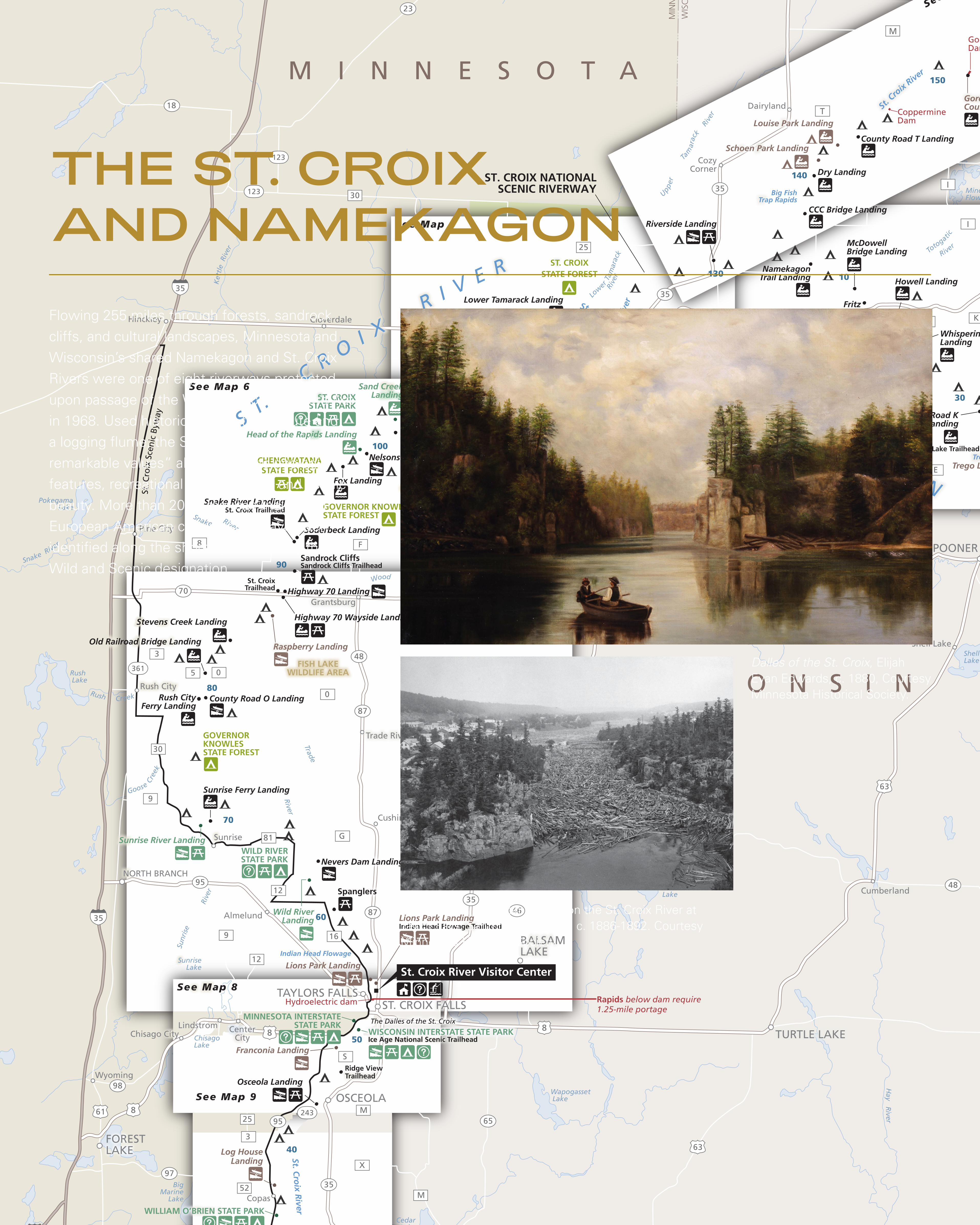
THE ST. CROIX AND NAMEKAGONFlowing 255 miles through forests, sandrock
cliffs, and cultural landscapes, Minnesota and
Wisconsin’s shared Namekagon and St. Croix
Rivers were one of eight riverways protected
upon passage of the Wild and Scenic Rivers Act
in 1968. Used historically as a trade route and
a logging flume, the St. Croix’s “outstandingly
remarkable values” also include its geologic
features, recreational opportunities, and scenic
beauty. More than 200 American Indian and
European American cultural sites have been
identified along the shores protected by the
Wild and Scenic designation.
View looking down on log jam on the St. Croix River at Taylor Falls, Sanford C. Sargent, c. 1886-1892. Courtesy Minnesota Historical Society
Dalles of the St. Croix, Elijah Evan Edwards, c. 1880, Courtesy Minnesota Historical Society.