Wet land In ven t ory adopts new tech nol ogy
16
Winter, 2003 1 Wisconsin Mapping Bulletin Vol. 29, number 1 Winter 2003 Wisconsin MAPPING BULLETIN Reporting on Mapping and Land Information in Wisconsin Wetland Inventory adopts new technology State Cartographer’s Office Highlights of this issue.... Doyle proposes WLIB extension ..........................5 Find control points through web map...................8 Bulletin will become digital ...............................13 Helps produce an improved product by Ted Koch The map ping of Wis con sin’s wetlands reaches all the way back into the 19 th cen tury. All along the way, tech nol ogy has had a large impact on how the map ping could be done, and now in the early years of the 21 st cen tury an other new ap proach is be ing imple mented. The ear liest map ping co mes from the orig i nal gov ern ment land sur - veys be gun in the 1830s and completed in the 1860s. The sur vey crews mapped about 5 million acres of wetland. Al though the sur vey gave a good dis tribu tion and ex tent of Wis con sin’s orig i nal wetlands, it did not yield very ac cu rate sta tis tics. Sur vey meth ods and map ping were primi tive and dif fer ent sur vey - ors had dif fer ent in terpre ta tions of what con stituted a wet land. Some of the work was done in the win ter when wetlands were cov ered by ice and snow. The wetland bound aries were mapped more accu rately along the Pub lic Land Sur vey System (PLSS) section lines than in the in te ri ors of the sections since the sur veyors only walked the section lines. When the sur vey maps were drawn, the land cover be tween the sec tion lines was es ti mated. Sub se quent WI De part ment of Nat u ral Re sources (DNR) com par i - sons of the orig i nal gov ern ment land sur vey with the Wis con sin De - part ment of Ag ri cul tural’s Land In ven tory (“Bordner Sur vey”) done in the 1930’s and USGS top o graphic maps in di cate that wetlands were fre quently drawn too small on the orig i nal sur vey maps and some types of wetlands were over looked. The ex tent of wet soils pro vides a more accu rate picture of the state’s orig i nal wet land acre age. Soil sci en tists es ti mate that Wis consin has ap prox i mately 10 million acres of wet soils (some what poorly, poorly, and very poorly drained) which is a much more accu rate count of Wis con sin’s pre-set tle ment wet land acre age. Acreage monitored through Wetland Inventory Since 1978 the state’s wetlands have been mapped by the DNR under the Wisconsin Wetland Inventory (WWI) program. Wetlands mapping was initially completed statewide in 1985, based on aerial photography flown in 1978-79. At that time it showed approximately 5.3 million acres of wetlands remaining in the state, a loss of about 47% of original acreage. The state leg is la ture au tho rized the DNR to up date the WWI on a 10-year cycle. Sub se quent bud get con straints and lack of staff have slowed this pro cess to a much lon ger cycle. Cur rently, three to four of the state’s 72 coun ties are mapped an nu ally. The pri mary source in for ma tion for wetlands iden ti fi ca tion is spring (leaf-off) black-and-white in fra red aerial pho tog ra phy flown at a scale of 1:20,000 (1"=1667’). Using this imag ery, ex pert photo in - ter pret ers are able to de lin eate the ex tent of many cat e go ries of wet - land fea tures. In fra red im ages pro vide a much clearer in di ca tion of wa ter than does the more stan dard black-and-white pho tog ra phy. continued on page 3... Digital WWI Status as of March, 2003
Transcript of Wet land In ven t ory adopts new tech nol ogy

Winter, 2003 1 Wisconsin Mapping Bulletin
Vol. 29, num ber 1 Winter 2003
Wis con sin
MAPPING BUL LE TINRe port ing onMap ping andLand In for ma tionin Wis con sin
Wet land In ven tory adopts new tech nol ogy
State Car tog ra pher’s Of fice
High lights of this is sue....
Doyle pro poses WLIB ex ten sion ..........................5
Find con trol points through web map...................8
Bul le tin will be come dig i tal ...............................13
Helps pro duce an im proved prod uct
by Ted Koch
The map ping of Wis con sin’s wetlands reaches all the way back into
the 19th cen tury. All along the way, tech nol ogy has had a large im pact
on how the map ping could be done, and now in the early years of the
21st cen tury an other new ap proach is be ing im ple mented.
The ear li est map ping co mes from the orig i nal gov ern ment land sur -
veys be gun in the 1830s and com pleted in the 1860s. The sur vey
crews mapped about 5 mil lion acres of wet land. Al though the sur vey
gave a good dis tri bu tion and ex tent of Wis con sin’s orig i nal wetlands,
it did not yield very ac cu rate sta tis tics.
Sur vey meth ods and map ping were prim i tive and dif fer ent sur vey -
ors had dif fer ent in ter pre ta tions of what con sti tuted a wet land. Some of
the work was done in the win ter when wetlands were cov ered by ice
and snow. The wet land bound aries were mapped more ac cu rately
along the Pub lic Land Sur vey Sys tem (PLSS) sec tion lines than in the
in te ri ors of the sec tions since the sur vey ors only walked the sec tion
lines. When the sur vey maps were drawn, the land cover be tween the
sec tion lines was es ti mated.
Sub se quent WI De part ment of Nat u ral Re sources (DNR) com par i -
sons of the orig i nal gov ern ment land sur vey with the Wis con sin De -
part ment of Ag ri cul tural’s Land In ven tory (“Bordner Sur vey”) done in
the 1930’s and USGS top o graphic maps in di cate that wetlands were
fre quently drawn too small on the orig i nal sur vey maps and some
types of wetlands were over looked.
The ex tent of wet soils pro vides a more ac cu rate pic ture of the
state’s orig i nal wet land acre age. Soil sci en tists es ti mate that Wis con sin
has ap prox i mately 10 mil lion acres of wet soils (some what poorly,
poorly, and very poorly drained) which is a much more ac cu rate count
of Wis con sin’s pre-set tle ment wet land acre age.
Acre age mon i tored through Wet land In ven tory
Since 1978 the state’s wetlands have been mapped by the DNR
un der the Wis con sin Wet land In ven tory (WWI) pro gram.
Wetlands map ping was ini tially com pleted state wide in 1985,
based on ae rial pho tog ra phy flown in 1978-79. At that time it
showed ap prox i mately 5.3 mil lion acres of wetlands re main ing
in the state, a loss of about 47% of orig i nal acre age.
The state leg is la ture au tho rized the DNR to up date the WWI on a
10-year cy cle. Sub se quent bud get con straints and lack of staff have
slowed this pro cess to a much lon ger cy cle. Cur rently, three to four of
the state’s 72 coun ties are mapped an nu ally.
The pri mary source in for ma tion for wetlands iden ti fi ca tion is
spring (leaf-off) black-and-white in fra red ae rial pho tog ra phy flown at
a scale of 1:20,000 (1"=1667’). Us ing this im ag ery, ex pert photo in -
ter pret ers are able to de lin eate the ex tent of many cat e go ries of wet -
land fea tures. In fra red im ages pro vide a much clearer in di ca tion of
wa ter than does the more stan dard black-and-white pho tog ra phy.
con tin ued on page 3...
Dig i tal WWI Sta tusas of March, 2003
Wisconsin Mapping Bulletin 2 Winter, 2003
..........State Land In for ma tion News ............................................................................................ ..............
State Car tog ra pher’s Com men tary
Let’s com plete the soil map ping
by Ted Koch
If the state bud get is en acted as in tro duced, the
State of Wis con sin will re nege on the soil
map ping con tract—a six-year agree ment be -
gun four years ago to com plete dig i tal soil
map ping state wide. In my view such an out -
come would send the wrong mes sage about
inter-gov ern men tal co op er a tion and cause an
awk ward in ter rup tion to a valu able pro ject that
is ahead of sched ule and close to com ple tion.
The state’s an nual fi nan cial com mit ment to
this pact has been $700,000. The Land In for -
ma tion Pro gram has funded $415,000, while
the De part ments of Trans por ta tion and Nat u ral
Re sources have each added $132,600, and the
Board of Com mis sion ers of Pub lic Lands has
pro vided the re main der ($19,800).
Pro ject be gan with ques tions
When the Land In for ma tion Board voted
four years ago to com mit $2.5 mil lion of
its funds to soil map ping, con tro versy
erupted in re ac tion to the de ci sion. Many
in the state’s land in for ma tion com mu nity
WLIB News
by Ted Koch
The Wis con sin Land In for ma tion Board’s
most re cent meet ings were held on De cem ber
12 in Mad i son, a con fer ence call on Jan u ary 3,
and on April 3 in Mad i son. The Board’s next
meet ing will be in June, at a date to be de ter -
mined.
State agency designees change
With the re cent elec tion of Jim Doyle as Gov -
er nor, and the re sul tant changes in state de part -
ment sec re tar ies, agency rep re sen ta tion on the
Board has changed in sev eral in stances. The
new designee from the De part ment of Ad min -
is tra tion is the Dep uty Sec re tary, Laura Engan.
She was for merly the City of Mil wau kee’s
bud get di rec tor. Rep re sent ing the De part ment
of Nat u ral re sources will be Brenda Hagman,
the de part ment’s Chief in for ma tion Of fi cer.
Ja son Helgerson, Ex ec u tive As sis tant, will be
rep re sent ing the De part ment of Rev e nue.
Nick Neher, Dept. of Ag Trade and Con sumer
Pro tec tion, and Tanace Matthiesen, Dept. of
felt the Board had ex ceeded its au thor ity
in com mit ting funds to a state wide ef fort.
Also, much doubt sur faced about the
abil ity of the NRCS (USDA-Nat u ral Re -
sources Con ser va tion Ser vice) to de liver
the dig i tal map prod ucts within the
prom ised six-year time frame.
Let’s take a look at this pro ject's ac com -
plish ments over four years, and what re mains
to be done. The goal is to com plete the ini tial
soil sur veys for ten coun ties lo cated in north -
west Wis con sin, and to con vert to dig i tal
form ex ist ing soil sur veys of 28 ad di tional
coun ties. Of those 28 coun ties, four teen have
the dig i tal prod uct com plete and cer ti fied, two
are in fi nal cer tif i ca tion re view, eight are be -
ing dig i tized; only four coun ties re main to be
started. In the north west coun ties, half of the
3.5 mil lion acres is mapped; the re main der is
in var i ous stages of work.
Evolving map ping tech niques
Soil map ping re lies on skilled sci en tists
and tech ni cians to do field work, dig i tal
con ver sion, and cer tif i ca tion. To meet
Trans por ta tion, will con tinue to rep re sent
those agen cies.
Board ac cel er ates ac cess to funds
At its De cem ber 12 meet ing the Board dis -
cussed the pos si bil ity of an ear lier sys tem of
award ing grants funded from fees col lected in
Fis cal Year 2003—prior to June 30, rather
than af ter the end of the year as has been the
rule over the past years. The board ex plored
this op tion in light of the pos si bil ity that it may
cease to func tion af ter Sep tem ber 1 due to the
cur rent leg is la tively spec i fied sun set. The
Board di rected its Ex ec u tive Com mit tee to in -
ves ti gate ex tend ing the ap pli ca tion pe riod for
the cur rent 2002 grant cy cle, and to as sure that
all pro vi sions of the stat utes and grant ad min -
is tra tive rule are met.
Dur ing its Jan u ary 3 con fer ence call the
Board ap proved an ex ten sion to the 2002
grant pe riod to spend those funds col lected in
Fis cal Year 2003. This ex ten sion had been
rec om mended by the Ex ec u tive Com mit tee.
In this ac tion the Board made avail able an ad -
di tional $1,746,539, al lo cat ing the fol low ing:
$21, 600 for Ed u ca tion and Train ing grants,
$269,556 for the Base-Bud get grant com po -
nent, and an ad di tional $855,383 for the Con -
tri bu tion-Based grant cat e gory. In mak ing
these funds avail able the Board in ef fect dou -
bled the amount avail able in each of these
three grant cat e go ries. In the fourth grant cat e -
gory, Stra te gic Ini tia tive, the Board made
avail able $600,000 for dig i tal par cel map ping
pro vided use of the money leads to 100% par -
cel map ping com ple tion in the pri or ity ranked
ar eas of: 1) a com plete county, 2) un in cor po -
rated ar eas of a county, and 3) 100% of the
par cels in a town, city and/or vil lage.
In this ac tion, the Board au tho rized no
funds for floodplain map ping, or for the de vel -
op ment of dis trib uted nodes of the
Internet-based Wis con sin Land In for ma tion
Sys tem (WLIS). These two cat e go ries are
part of the orig i nal 2002 grant pro gram.
At the April 3 meet ing, is sues of ad dress ing
and el e va tion data were con sid ered by no ac -
tion was taken. Elec tions were de ferred.
this need NRCS hired and trained six ad -
di tional per ma nent staff, and to ac cel er -
ate the pro cess adopted new com -
puter-based tech niques in field data col -
lec tion, and added new soft ware in the
map ping pro cess. This ac tiv ity has made
Wis con sin a leader in soil map ping ap -
proaches, and if com pleted in two more
years as sched uled, the state will rank in
the top three na tion ally for com plete
avail abil ity of dig i tal soil data.
Soil map ping is a Land In for ma tion Pro -
gram Foun da tional El e ment and a crit i cal re -
source for com pre hen sive plan ning, farm land
pro tec tion, proper use of land for con ser va tion
and de vel op ment, and more..
For ev ery state dol lar in this pro ject, the
fed eral con tri bu tion is $3.5— an ex cel lent ra -
tio. Work is ahead of sched ule, the end is in
sight, NRCS has the skilled hu man in fra struc -
ture in place, and the Land In for ma tion Pro -
gram has the money to fund the pro ject to
com ple tion. Let’s ad just the bud get and get
this job done.

Winter, 2003 3 Wisconsin Mapping Bulletin
......................................................................................................................State Map ping & Coordination ..................
Wet land In ven tory adopts new tech nol ogy, con tin ued from page 1
New ap proaches
Re cently, the DNR has adopted some mod ern ized tech nol ogy
to im prove the map ping pro cess, not only to speed up the ac -
tual map ping, but to im prove the ac cu racy of the fi nal prod uct.
The new tech nol ogy in volves trans fer ring the wet land ar eas as
de lin eated on the ae rial photo to a scale-cor rected im age
(orthophoto) that then yields far more ac cu rate wet land acre age
mea sure ments. The orthophoto pro cess also elim i nates sev eral
for mer data trans fer steps in the com pi la tion pro cess, which in
turn speeds up the over all pro duc tion pro cess.
DNR wetlands map ping staff ers Lois Si mon and Cal vin Law rence
are still in the pro cess of iron ing out some of the kinks in the new pro -
cess, work ing on map ping data for Outagamie and Waupaca Coun ties
as test ar eas. They cre ate the orthophoto photo base im ages from the
in fra red im ag ery us ing OrthoMapper, a soft ware pro gram cre ated by
Pro fes sor Frank Scarpace of UW-Mad i son.
Over the past de cade DNR staff has been elec tron i cally dig i tiz ing
the ex ist ing WWI maps which are in the form of an un cor rected ae rial
pho to graph, film-based sheets cov er ing a 36-square mile town ship at a
scale of 1:24,000 (1"=2000’). Al though, the wet land data is in dig i tal
form, the fact that it has been plot ted on an un cor rected
(non-orthophoto) base means that the dig i tal data does not edge match
well from town ship to town ship and is there fore not a seam less prod -
uct over an en tire county or large area. The new map ping pro cess cor -
rects this prob lem, al low ing the data to be more ac cu rately in te grated
with other data lay ers and GIS ap pli ca tions.
Wet land In ven tory maps are avail able from the WIDNR in pa per
form for $5 a town ship, or $15 in dig i tal for mat. See the DNR
website un der Wetlands Map ping for more in for ma tion:
www.dnr.state.wi.us/org/wa ter/fhp/wetlands/in dex.shtml.
Sur pris ingly, the Wis con sin Wetlands In ven tory is not part of the
Na tional Wetlands In ven tory (NWI) main tained by the U.S. Fish and
Wild life Ser vice. The NWI cov ers all of the lower 48 states ex cept
Wis con sin, with ap prox i mately 44% of that area in dig i tal form.. For
more in for ma tion on the NWI, visit: wetlands.fws.gov/.
Por tion of 1993 WI Wet land In ven tory Map of Town of Dayton, Waupaca County, (scale: 1" = 2000'), show -ing de lin eated wet land ar eas and clas si fi ca tion codes. Code ex am ple: T3K is wetsoil, for ested with broad-leafdeciduous trees.

Wisconsin Mapping Bulletin 4 Winter, 2003
...............State Study Groups ............................................................................................................................................
State task force makes rec om men da tions
Di rec tions pro posed for el e va tion data
by Bob Gurda
Wis con sin needs better el e va tion data and can make strides to ward
achiev ing that goal, ac cord ing the the Wis con sin Land In for ma tion
Board’s El e va tion Data Task Force (EDTF). The task force, led by
NGS State Geo detic Ad vi sor D. Da vid Moyer, fin ished its work re -
cently and re ported its find ings and rec om men da tions to the board.
The task force be gan meet ing in the Spring of 2001.
In a nut shell, the re port calls for ac tions by a va ri ety of or ga ni za -
tions to more ef fec tively mon i tor, en cour age, and co or di nate de vel op -
ment of more ro bust el e va tion data across the state. Due to the va ri ety
of ap pli ca tions us ing el e va tion data, the range of nec es sary ac cu racy,
the con tin u ing evo lu tion of data cap ture tech nol ogy, and the sig nif i -
cant costs in volved, the task force did not set tle on a sin gle ap proach
or ac cu racy level.
Who should do what?
The var i ous needs for el e va tion data arise in a wide va ri ety of
pro gram ar eas and lev els of gov ern ment and busi ness. Sim i -
larly, re spon si bil ity for de vel op ing, main tain ing, and dis trib ut -
ing el e va tion data can be em bed ded in sev eral places within
the af fected in sti tu tions.
The task force rec om mended that sev eral or ga ni za tions take on key
roles. What fol lows is an ex cerpted list:
Wis con sin Land In for ma tion Board
· Ed u cate re gard ing needs and op por tu ni ties
· Sup port Wis. Dept. of Nat u ral Re sources floodplainmap ping ef forts
· En cour age lo cal gov ern ments to co op er ate with stateand fed eral agen cies, and to sup port the Height Mod -ern iza tion Pro ject.
· De velop DEM spec i fi ca tion
· Es tab lish a Geo detic Stan dards and Spec i fi ca tionsWork Group
· Adopt “hy dro en forc ing” (a tech nique to rec on cile el e -va tion data with mapped streams and lakes).
· De ter mine host agency and dis tri bu tion pro cesses.
· En cour age use of in-state con trac tors.
State Car tog ra pher’s Of fice
Main tain and make avail able el e va tion metadata free of
charge, in te grat ing DEM and floodplain map ping pro ject foot -
prints when avail able, and in te grate sim i lar track ing for
orthophotos and ae rial pho tog ra phy pro jects.
Wis. Dept. of Nat u ral Re sources
Lead ef forts at im prov ing floodplain map ping by seek ing
cost-share funds, co or di nat ing floodplain and el e va tion as pects
of the state’s I-Team Plan, gain ing higher-level part ner ship
with FEMA, de vel op ing MOAs with mu nic i pal i ties in flood
prone ar eas, and mak ing dig i tal data and tools web-ac ces si ble.
Ques tions arise on con ver sion de tails
County co or di nate sys tem to be an a lyzed
by Ted Koch
The Wis con sin County Co or di nate Sys tem (WCCS) has come to be
widely used by county, re gional, and some state agen cies as the foun -
da tion for stor ing, dis play ing, and map ping geo graphic data. Since
other co or di nate sys tems are also widely used, con vert ing co or di nate
val ues be tween the var i ous sys tems has be come a rou tine ac tiv ity
The WCCS, which was de signed and de vel oped by the WI Dept.
of Trans por ta tion a de cade ago, min i mizes dif fer ences be tween mea -
sure ments on the ground and cor re spond ing dis tances cal cu lated on
the WCCS. The WCCS is math e mat i cally based and re lated to the
Na tional Geo detic Ref er ence Sys tem. Cur rently, well over three quar -
ters of the state’s 72 coun ties use the WCCS as the ba sis for stor ing
and dis play ing their GIS data.
Con cerns over im ple men ta tion and stan dards
Re cently, a num ber of peo ple have con tacted the State Car tog -
ra pher’s Of fice with con cerns about how some us ers of the
WCCS have im ple mented county co or di nates within their soft -
ware en vi ron ment, and how ef fec tively dif fer ent soft ware
prod ucts con vert data in mul ti ple for mats into and out of the lo -
cal co or di nates. Ul ti mately, the ques tion has arisen about
whether there is truly a stan dard method for trans form ing data
into and out of the WCCS.
Be gin ning the dis cus sion
To be gin to an swer this and re lated ques tions, the State Car tog -
ra pher’s Of fice in Feb ru ary in vited fif teen “GIS ex perts” to
dis cuss WCCS-re lated is sues. The pur pose of the meet ing was
to better iden tify cur rent prob lems with WCCS use and to pro -
pose po ten tial paths for res o lu tion of this prob lems. Ac tion
items iden ti fied at this meet ing in clude in ves ti ga tions on more
for mally de fin ing pa ram e ters needed to use the WCCS, build -
ing valid test data, and form ing a task force at tached to a rec og -
niz able body, such as the WI Land In for ma tion Board, to con -
tinue WCCS work.
The is sue of form ing a task force was not taken up at the WLIB’s
most re cent meet ing in early April, be ing post poned un til the next
meet ing date. Look for up dates in fu ture Bul le tin is sues.
Wis. Dept. of Trans por ta tion
Ac cel er ate the Height Mod ern iza tion Pro gram (HMP) in clud -
ing fed eral fund ing, share bridge and cul vert ca pac ity data with
DNR, en cour age and fa cil i tate county sup port of the HMP, and
en cour age the use of Wis. con trac tors that are tech ni cally qual i -
fied and eco nom i cally com pet i tive.
Full re port avail able
The full re port is ex pected to be avail able for down load from
the Of fice of Land In for ma tion Ser vices’ web site:
www.doa.state.wi.us/dhir/in dex.asp.

Winter, 2003 5 Wisconsin Mapping Bulletin
......................................................................................................................Gov ern ment Fund ing & Ini tia tives ............
Sep tem ber 1, 2005 would be new sun set
Gov er nor pro poses extending the WLIB
by Ted Koch
Wis con sin Gov er nor Jim Doyle’s pro posed bud get for the State of
Wis con sin’s next two fis cal years (July, 2003-June, 2004) con tains a
pro vi sion for re sched ul ing the sun set date for the Wis con sin Land In -
for ma tion Board (WLIB) from Sep tem ber 1, this year to Sep tem ber 1,
2005. A sim i lar ex ten sion is also pro posed for the Wis con sin Land
Coun cil (WLC). The gov er nor’s bud get was de liv ered to the leg is la -
ture in late Feb ru ary.
Cur rently, the leg is la ture’s Joint Com mit tee on Fi nance is an a lyz ing
the bud get and trav el ing around the state hold ing hear ings to gather
pub lic com ments. In Spring and early sum mer, the com mit tee will
make their changes to the bud get be fore re turn ing the amended ver -
sion to the gov er nor for his sig na ture. The gov er nor has the au thor ity
to se lec tively veto or al ter leg is la tive changes.
Huge bud get def i cit may force fund ing shifts
This bud get is un like any other in re cent mem ory since the
state is fac ing a huge def i cit es ti mated to be well over $3 bil -
lion. A def i cit of that mag ni tude has forced the ad min is tra tion
to take a very close look at the fund ing of all state pro -
grams—those funded through gen eral rev e nues as well as those
re li ant on spe cific pro gram rev e nue such as the Land In for ma -
tion Pro gram (which gets its funds from a real es tate re cord ing
fee col lected by coun ties.
Na tional Re search Coun cil weighs in
“The Na tional Map” critiqued
by Bob Gurda
The Na tional Map, the key idea be hind the
reinvention of map ping within the U.S. Geo -
log i cal Sur vey (USGS), has been stud ied by a
panel of the Na tional Re search Coun cil. We
have cov ered the evo lu tion of The Na tional
Map in sev eral pre vi ous ar ti cles.
The panel’s pri mary con clu sion ap pears to
be that the goals are laud able and crit i cal to the
coun try, but that achiev ing suc cess will re -
quire ma jor or ga ni za tional change, co or di na -
tion with sim i lar fed eral ini tia tives, and a huge
ef fort in build ing part ner ships.
The panel goes by the name of The Com -
mit tee to Re view the U.S. Geo log i cal Sur vey
con cept of The Na tional Map. Ap pointed
solely for the pur pose of this re view, it op er -
ated un der the aus pices of the per ma nent
Map ping Sci ence Com mit tee, be gin ning its
work in July, 2002.
In put was so lic ited from a wide range of
stake holders. A two-day work shop was held
Be sides the sun set ex ten sion, the gov er nor’s bud get al ters WLIP
fund ing. Most no ta ble of these changes is a com plete elim i na tion, by
the sec ond year of the bud get, of state fund ing for soil map ping. The
state, through a com bi na tion of WLIP funds and al lo ca tions from three
state agen cies, has been con trib ut ing $700,000 an nu ally to soil map -
ping and dig i tal con ver sion of ex ist ing pa per soil maps. This work has
been on go ing over the past four years un der a con tract with the Nat u ral
Re sources Con ser va tion Ser vice, a fed eral ag ri cul tural agency.
In ad di tion the soil map ping re duc tion, the pro posed bud get re duces
sig nif i cantly funds for the Dept of Ad min is tra tion’s Of fice of Land In -
for ma tion Ser vices (OLIS) which ad min is ters the busi ness ac tiv i ties
for both the WLIB and WLC. This re duc tion, if it stays as part of the
fi nal bud get, will elim i nate six po si tions in OLIS, and stop fund ing for
the con tin ued de vel op ment of a re cently be gun pro ject (WLIS) to in te -
grate and dis play land in for ma tion data on the Internet.
Com pre hen sive plan ing grant fund ing re mains
An other pro vi sion of the gov er nor’s bud get calls for WLIP-col lected
rev e nue to be used as a re place ment for gen eral pur pose rev e nue in
fund ing com pre hen sive land use plan ning grants. In the last bud get,
$1.5 mil lion GPR and $500,000 of WLIP funds sup ported com pre -
hen sive plan ning. Un der the new bud get, GPR fund ing is elim i nated
and re placed with $1.5 mil lion in WLIP funds, thus main tain ing the
cur rent fund ing lev els for com pre hen sive plan ning.
in Sep tem ber. The re port is avail able as a
printed pub li ca tion from the Na tional Acad e -
mies Press (www.nap.edu/cat a log/
10606.html) for ap prox i mately $30. At press
time a PDF was view able on line. The doc u -
ment runs 140 pages and is ti tled Weav ing a
Na tional Map: A Re view of the U.S. Geo log i -
cal Sur vey Con cept of The Na tional Map.
Ob ser va tions by the com mit tee
Based on the re port’s Ex ec u tive Sum -
mary, the panel clearly un der stood the
na tion’s needs for dig i tal geo graphic in -
for ma tion that is cur rent, ac cu rate, and
stan dard ized. The com mit tee also was
aware that rec om men da tions had been
pro vided to the USGS over the last de -
cade and had they been im ple mented
much of the idea of The Na tional Map
would al ready be in place. Fur ther, the
panel ap pre ci ated that other fed eral pro -
grams are ac tive in the area of geo -
graphic in for ma tion.
From this back ground, the com mit tee con -
cluded that The Na tional Map is a large, am -
bi tious pro ject that is more an in sti tu tional
than tech ni cal or sci en tific chal lenge. Suc cess
de pends on some fac tors out side the con trol
of the USGS. En hanced co or di na tion that
uses a two-way street ap proach is es sen tial.
Rec om men da tions
The com mit tee ad vised the USGS to
make a pri or ity of build ing part ner ships
for an in te grated spa tial da ta base, and at
the same time use small steps and pi lot
pro jects to gain ex pe ri ence in re vi sion,
in te gra tion, and up dat ing.
The panel also iden ti fied a role for the ex -
ist ing dig i tal Na tional At las, be ing a less-de -
tailed source of in for ma tion (con trib uted from
and main tained by var i ous or ga ni za tions),
while more-de tailed in for ma tion is be ing as -
sem bled at a slower pace.
In to tal, the rec om men da tions lay out a ma -
jor shift for the USGS in re for mu lat ing its
staff and pro cesses to rise to the chal lenges of
the 21st cen tury.

Wisconsin Mapping Bulletin 6 Winter, 2003
Six teen years ago you were one of the peo ple who formedthe Wis con sin Land In for ma tion As so ci a tion. What havebeen the key ac com plish ments of the WLIA over that time?
Many of us char ter WLIA mem bers were ac tive in the Wis con sinLand Re cords Com mit tee, and form ing the WLIA to push for wardthe rec om men da tions of that com mit tee was fore most in our minds.So, I would say that con vinc ing the leg is la ture and gov er nor to es tab -lish and fund the Land In for ma tion Pro gram was the first goal of theas so ci a tion, and in ret ro spect the most es sen tial ac com plish ment.
The stron gest ev i dence of the pro gram’s value is that all 72 coun tieshave long been par tic i pat ing.
A de cade and a half later, what has changed the mostin terms of ac cep tance of the pro gram?
Ini tially, there were plenty of doubt ers sprin kled through outgov ern ment staff and county boards. Af ter all, GIS and re latedap proaches like GPS and doc u ment im ag ing were new tech nol -o gies, re quire in vest ment up front, and re quire new ways ofwork ing be tween of fices. Yet, as the suc cess sto ries be gan topile up most of the re sis tance faded and some doubt ers be camethe stron gest sup port ers.
A new wave of county staff and board mem bers has alsobrought with them a higher com fort level with in for ma tion tech -nol ogy — in some cases even very high ex pec ta tions.
What we didn’t an tic i pate early on was the cool treat ment thatemanted from some places high in state gov ern ment for a long time. We are hope ful that our ideas will be em braced more warmly by thenew ad min is tra tion. It is clear that the value of land in for ma tion sys -tems is ap pre ci ated more than ever across the po lit i cal spec trumwithin the leg is la ture.
As a Reg is ter of Deeds, you have been a strong pro po -nent of doc u ment im ag ing. Was this a fo cus for youfrom your ear li est aware ness of land re cords?
No, it wasn’t. As mem ber of the county board first and then as a grad u ate stu dent, I be came keenly aware of the op por tu ni tiesthat land re cords mod ern iza tion pre sented. But doc u ment im -
Im ag ing and Imag in ing the Fu ture
...............Guest In ter view...................................................................................................................................................
ag ing wasn’t a prac ti cal tech nol ogy at the time. If it had been, Iex pect the Land In for ma tion Pro gram might have steered re -sources first to ward im ag ing sys tems for all coun ties since theygreatly help in achiev ing other pro gram goals such as par celmap ping.
In the early pe riod of my ten ure as Reg is ter of Deeds, though, I made avisit to Lexington, Ken tucky where the lo cal gov ern ment had starteddo ing im ag ing. Then my col league Helen Schutten in Ra cine Countystarted her sys tem in 1994. These ex am ples made it clear that mycounty and oth ers would ben e fit greatly.
I’m happy that 60 of our state’s 72 coun ties now have these sys temswhich make our of fices more ef fi cient, pro vide better ac cess for thepub lic and other county of fices, and en able Internet ac cess for pro fes -sional us ers.
Be yond its work in es tab lish ing the state land in for ma -tion pro gram, how has the WLIA been par tic u larly ef -fec tive?
There are so many things to con sider here. We have a news let ter andweb site and great ed u ca tional con tent at our meet ings around the state. We have de vel oped stan dards through a group pro cess. How ever, Ibe lieve that the sin gle most im por tant as pect of the WLIA is that as acom mu nity it rep re sents a store house of ideas, ex pe ri ence, and sup port that any one of us can draw on at any time. It’s great to be part of thisfam ily.
In re cent years GIS-savvy staff have joined al most all of the or ga ni za tions rep re sented in the WLIA. Thesemostly youn ger peo ple have dif fer ent train ing and ex pe -ri ence than many of their pre de ces sors, and some havebeen thrust into roles as co or di na tors. How mightWLIA help these peo ple through such a tran si tion?
Partly this goes back to the idea of WLIA as fam ily. We have lots ofmem bers with ex pe ri ence in bring ing an or ga ni za tion’s parts to getherto im ple ment a land in for ma tion sys tem. In a more or ga nized sense,we could con sider a mentoring ap proach and even some work shopson top ics such as con flict res o lu tion. We can all im prove our skills and WLIA could be the per fect ve hi cle to rise to this chal lenge.
Our mem bers from ed u ca tional in sti tu tions could also con sider al ter -ing some course con tent so that stu dents re ceiv ing tech ni cal GIS train -ing are ex posed more fully to or ga ni za tional and im ple men ta tion is -sues.
As the suc cess sto ries be gan to pile up some doubt ersbe came the stron gest sup port ers
We are hope ful that our ideas will be em braced morewarmly by the new ad min is tra tion
I’m happy that 60 of our state’s 72 coun ties now have doc u ment im ag ing sys tems
Jane Licht has just con cluded her one-yearterm as pres i dent of the Wis con sin Land In for -ma tion As so ci a tion. She is achar ter mem ber of WLIA, and has been Reg is ter of Deeds in DaneCounty for the last four teen years, and served on the county boardprior to that.

Winter, 2003 7 Wisconsin Mapping Bulletin
......................................................................................................................Ques tions & An swers ................................
I want to pre serve35mm color slides of farm fields by
scanning but don’t nec es -sar ily need to have the im -ages ad justed like anorthophoto. What guide -lines, such as res o lu tionand file nam ing, would you sug gest I fol low?
Q:
Pre sum ably you’re talk ing about the ae rial trans par en ciesthat were taken an nu ally for the Farm Ser vice Agency for
many years. That pro gram is in the pro cess of be ing phased out as weex plained in an ar ti cle on the new Na tional Ae rial Im ag ery Pro gram inour Fall 2003 is sue.
The color slides each de pict the farm fields in a sec tion (square mile,es sen tially) of land dur ing the grow ing sea son. The slides over a se ries of years rep re sent the only con tin u ous an nual re cord of ru ral land use. It’s good to see your in ter est in pre serv ing this re cord.
Equip ment to ac com plish high-res o lu tion scan ning of color slides isex pen sive so it prob a bly doesn’t make sense for you to pur chase thehard ware and do you own scan ning. A ser vice bu reau would be abetter choice. A con trac tor in Minocqua has scanned FSA slides for anum ber of Wis con sin coun ties.
As for res o lu tion, a tar get for a 1.0 x 1.5 inch 35mm slide might be2000 x 3000 pix els. A some what lower res o lu tion might pro vide ac -cept able im age qual ity; higher res o lu tions will re quire more stor agespace. Some scan ning sys tems au to mat i cally cre ate mul ti ple lowerres o lu tions to speed up view ing at var i ous zoom lev els.
It is com mon to com press im age scans to save com puter stor age space. Make sure that the com pres sion ra tio isn’t set so high that you see ano tice able de crease in im age qual ity. Com pressed files also tend totake lon ger to dis play on your com puter screen since the de com pres -sion step uses pro ces sor time.
Re gard less whether you de cide to em ploy com pres sion or not, it’s al -ways a good idea to ask for cop ies of the orig i nal scans for your ar -chives. A su pe rior com pres sion pro cess may emerge in fu ture yearsand then you’d want to go back to the orig i nal scans.
Scan ning and/or CD-ROM mas ter ing soft ware may not pro vide aneasy way to give im age scans file names that are mean ing ful. It’slikely that you would need to con struct a look-up ta ble with scannedfile names and the aliases you pre fer to use. These aliases would mostsen si bly be based on the PLSS town/range/range di rec tion/sec tion no -men cla ture.
A:
I own ru ral prop erty that is on a county line. Who do I con tact for the co or di nates of anearby sec tion cor ner so that I can check the
ac cu racy of my hand-held GPS re ceiver?
There are sev eral parts to your ques tion. We’ll look ateach of them sep a rately.
A sec tion cor ner is one of the places on the land where the Pub licLand Sur vey Sys tem (PLSS) is marked—of ten these days with sturdy mod ern mon u ments. A sec tion cor ner may or may not have been sur -veyed to gather high-ac cu racy co or di nate val ues. Such co or di natesare what you would need to be able to com pare your GPS re ceiver’sread ings with those for the mon u ment.
The county sur veyor or county land in for ma tion of fice would be theplace to con tact for in for ma tion on whether the PLSS cor ner in ques -tion has been remonumented and if so, whether high-ac cu racy co or di -nate val ues are avail able.
For a remonumented PLSS point that’s on a county line you may beable to tell from the mon u ment cap or nearby wit ness post whichcounty has been do ing the field work. Start with one county and askto be re ferred to an other if nec es sary.
If there are no high-ac cu racy co or di nates avail able for PLSS pointsclose to your prop erty you’ll have to ex pand your ho ri zons and searchfor a hor i zon tal geo detic con trol point. Start this pro cess by vis it ingour website’s ControlFinder ap pli ca tion (see story on page8). Re -mem ber that some points that were set years ago may be in lo ca tionswhere dense for est cover makes GPS sig nal re cep tion dif fi cult to day.
If that search turns up noth ing within a few miles of your lo ca tion,then con tact the county (or coun ties) to see if they have in for ma tion on con trol points that aren’t yet search able through ControlFinder.
It is pos si ble for there to be more than one set of lat i tude/lon gi tude val -ues for a point on a county line. That could oc cur as a re sult of sep a -rate hor i zon tal con trol net work ob ser va tions and ad just ments done bythe in di vid ual coun ties. How ever, the ex pected dif fer ences, if any,would likely be small frac tions of a foot.
Fi nally, once you have co or di nates for a con trol point, you’ll want todo GPS ob ser va tions there and com pare the re sults with the high-ac -cu racy val ues. You might want to make a se ries of read ings to buildup a sam ple.
Re mem ber that any ap par ent dif fer ence be tween what your re ceivercol lects and what the high-ac cu racy val ues are can be a re sult of a va -ri ety of fac tors: the type of re ceiver that you have, the num ber and po -si tions of GPS sat el lites in the sky at the time, ob struc tions and nearbysur faces that might re flect GPS sig nals, and re li ance on the pre dicted(rather than known) or bit of each sat el lite. Sur vey ors can deal withmany of these fac tors while you will have to ac cept a larger de gree ofun cer tainty due to lim i ta tions of your hand-held GPS unit.
Q:
A:

Wisconsin Mapping Bulletin 8 Winter, 2003
...............New Data Ser vices .............................................................................................................................................
SCO en ables search ing by web map
ControlFinder: Internet Accessible
Brenda Hemstead
The SCO is pleased to an nounce a new ser -
vice through our web site: lo cat ing in for ma -
tion about geo detic con trol points through a
web-based map in ter face. This ser vice is
called “ControlFinder,” and is part of a strat -
egy to evolve to ward sim i lar tools that pro vide
a range of car to graphic-re lated in for ma tion
through in tu itive web maps.
In the case of ControlFinder, the avail able
in for ma tion co mes from a va ri ety of sources.
In some cases we link you di rectly to other
web sites to ac cess the most cur rent in for ma -
tion. This as pect of the ser vice will be con -
stantly evolv ing as more and more data pro -
vid ers es tab lish co op er a tive ar range ments
with our of fice.
Search thou sands of pointsthrough one por tal
When plan ning or work ing on pro jects,
do you need to know where to find con -
trol mon u ments to es tab lish an el e va tion
or po si tion? If so, where do you eas ily
find this in for ma tion? Wis con sin has well
over 20,000 con trol points placed by nu -
mer ous agen cies over many de cades, so
the op tions for find ing in for ma tion are
var ied.
Our of fice has been the key point of con tact
for fed eral U.S. Geo log i cal Sur vey (USGS)
and Na tional Geo detic Sur vey (NGS) con trol
for over 20 years, pro vid ing in for ma tion on
hor i zon tal and ver ti cal con trol for the state.
With ControlFinder we are branch ing out to
make con trol in for ma tion from state and lo cal
of fices sim i larly ac ces si ble through a sin gle
point of en try on the Internet.
About ControlFinder
ControlFinder is de signed to help you
quickly find in for ma tion on var i ous
groups of geo detic con trol points in Wis -
con sin. It in cludes in for ma tion about geo -
detic con trol points set by the NGS, the
USGS, and some lo cal con tri bu tors (with
more to come).
This web-based tool uses map dis plays to
fa cil i tate search ing for points, then pro vides
de tailed in for ma tion on the point(s) you se lect.
Es sen tially, there are three com po nents to
ControlFinder; a Map tab for de fin ing your
area of in ter est, an Iden tify tab for choos ing
par tic u lar points, and a Re sults tab for list ing
your re sults in tab u lar form (with op tions for
print ing and sav ing).
Map
In map view (Fig ure 1) you use your
com puter’s mouse to zoom or nav i gate
through a dy namic map of the state. The
con trol point and ref er ence lay ers may be
turned on and off at your op tion.
Also avail able from the Map tab are links
to the metadata files for the var i ous con trol
point and ref er ence lay ers.
Iden tify
Step two in the pro cess uses the Iden tify
tab (Fig ure 2). Here you po si tion your
mouse cur sor and click on a point. Brief
in for ma tion about the se lected point(s)
will then ap pear along side the map win -
dow.
Fig ure 2: Iden tify tab
Fig ure 1: Map tab
con tin ued on next page...

Winter, 2003 9 Wisconsin Mapping Bulletin
......................................................................................................................New Data Ser vices......................................
Be low the point char ac ter is tics are two
hyperlinks; the first, View Full Re cord, leads
to more de tailed point and dataset in for ma tion
dis played in a new win dow (Fig ure 3). The
sec ond, Add to Re sults, adds the point to a
user-de fined list that is main tained for your
cur rent ses sion with ControlFinder. Points in
this list are sym bol ized on the in ter ac tive map
and re main se lected un til you leave the ap pli -
ca tion.
Re sults
The fi nal step, the Re sults tab, is where
you view, print, or save point char ac ter -
is tics in tab u lar form. Only the points
you have se lected ear lier in step 2, by
click ing on Add to Re sults, will ap pear in
the re sults col lec tion (Fig ure 4).
Con tents
At this point in its evo lu tion,
ControlFinder dis plays graph i cally the
state wide USGS 3rd or der ver ti cal con trol
and NGS ver ti cal/hor i zon tal con trol, as
well as con trol points from sev eral coun -
ties. USGS con trol in for ma tion is static,
but we pro vide trans par ent ac cess di -
rectly to the lat est ver sions of the NGS
datasheets. We can build live links into
other Internet sites for true dis -
trib uted ac cess from mul ti ple
sites, all through the
ControlFinder por tal.
Easy to use
ControlFinder sup ports the ma -
jor ity of cur rent brows ers at
1024 X 768 res o lu tion or better
and is ac ces si ble 24/7. The dis -
play has an un clut tered look
and cur rently uses min i mal ref -
er ence fea tures as a trade-off
for peak per for mance. Visit
ControlFinder at www.ge og ra -
phy. wisc.edu/sco.
Sav ing time & money
Our pri mary goal be hind
ControlFinder is to pro vide a
free, easy-to-use, Internet-ac -
ces si ble ap pli ca tion that de liv ers use ful
in for ma tion about geo detic con trol points
from dis trib uted sources state wide.
Or ga ni za tions that ar range with us to have
their con trol ac ces si ble through ControlFinder
should also see a time sav ings from fewer in -
qui ries from us ers seek ing in for ma tion.
Fig ure 4: Re sults tab
Data stew ard ship
We have de signed ControlFinder to in te -
grate dis trib uted map in for ma tion ser vices
as well as data ex ports to our server from
our con tri bu tors. In ei ther case, the con -
trib ut ing agency main tains com plete au -
thor ity, stew ard ship, and re spon si bil ity
for their data. All ques tions re gard ing
con trol point in for ma tion should be di -
rected to the con tact iden ti fied in the cat a -
log as the orig i nal source.
Fu ture
In build ing ControlFinder, we cre ated an
ex pand able cat a log that is eas ily adapted
to other point in for ma tion. For in stance,
Pub lic Land Sur vey cor ners are an other
theme we are plan ning to make search -
able through this mech a nism.
As with lo cally man aged geo detic con trol,
data on PLSS cor ners can ei ther be con trib -
uted pe ri od i cally to ControlFinder’s cen tral re -
pos i tory, or be made ac ces si ble di rectly from
the source through ControlFinder’s in ter face.
ControlFinder will pro vide you with ac cess
to needed in for ma tion more quickly and eas ily
than be fore. With data con tri bu tions from a
va ri ety of or ga ni za tions and feed back from
our us ers it will only im prove over time.
Fig ure 3: View full re cord

Wisconsin Mapping Bulletin 10 Winter, 2003
...............Fea tured Websites..............................................................................................................................................
Metadata...data...webmap...ap pli ca tion
DNR ATRI pro gram ex pands vis i bil ity
by AJ Wortley and Bonner Karger
For an or ga ni za tion, get ting a han dle on en ter prise data hold ings is
no small task. Sim i larly, de vis ing a frame work for in te grat ing
those data in a con text built for de ci sion-mak ers is a ma jor chal -
lenge.
But that is pre cisely the in tent of the Aquatic and Ter res trial Re -
source In ven tory (ATRI) pro gram at the Wis con sin De part ment of
Nat u ral Re sources. From con cept to ap pli ca tion, for sev eral years
the DNR has been con struct ing this im por tant part of their de part -
men tal in for ma tion in fra struc ture.
In the be gin ning...
Con cep tu ally, the ATRI is a pub lic and pri vate part ner ship
ini tia tive spurred by de ci sion-mak ers’ need to eas ily ac cess
and in te grate en vi ron men tal in for ma tion. Stat u to rily, the DNR
was di rected to, “de velop an in for ma tion sys tem to ac quire, in -
te grate, and dis sem i nate in for ma tion con cern ing in ven to ries
and data on aquatic and ter res trial nat u ral re sources.”
As part of the pro gram, DNR staff or ga nized in 2000 a Data Stan -
dards Ini tia tive which gen er ated a dy namic doc u ment of stan dards
deal ing with data col lec tion, metadata, and locational data. Steps were
taken to in ven tory and doc u ment in ter nal data hold ings, re sult ing in a
metadata da ta base of rel e vant spa tial and tab u lar data sources. Now,
af ter an ex ten sive pro gram re view over the last year, and ex panded
out reach and ap pli ca tion ef forts, ATRI has emerged vis i bly in the
form of a web-map ping part ner ship, an on-line metadata ex plorer, and
ini tial on-line tools that sup port de ci sion-mak ing.
Re volv ing around data
From its ini tial stages, ATRI has been cast as a data-centric
pro gram, fo cus ing on rel e vant data for aquatic and ter res trial
re source anal y sis by the de part ment, its part ners, and the gen -
eral pub lic. The in tent is es sen tially to cre ate a mid dle-tier in -
for ma tion frame work on top of the dis trib uted raw data hold -
ings. This frame work will fa cil i tate iden ti fi ca tion, in ven tory,
in ter me di ate stor age, and dis tri bu tion of these data.
Cen tral to such a frame work is a metadata re pos i tory, as de scribed
in the in tro duc tion to the 2000 Data Stan dards doc u ment. A metadata
re pos i tory pro vides light weight de scrip tions, con straints, and ac cess
routes to data sources, all housed in a search able, sortable, and spa -
tially-in dexed da ta base. The re sult is the abil ity to an a lyze the in for -
ma tion frame work it self for data gaps and over laps, ag ing or ob so lete
re sources, and mon i tor ing user de mand on the hold ings. The DNR
de signed an in ter face to the metadata re pos i tory to pro vide ben e fits in -
side the de part ment as well as to out side us ers through a pub lic ATRI
In ven tory Ex plorer (www.dnr.state.wi.us/atri/) in ter face.
In ven tory Ex plorer
Al though metadata is a fairly sim ple (yet very im por tant) con -
cept, great or ga ni za tion and clar ity in pre sen ta tion are nec es -
sary when at tempt ing to make this in for ma tion eas ily un der -
stood. The ATRI In ven tory Ex plorer does just that.
You need not be an ex pert to nav i gate through and find the in for -
ma tion you seek. Search the da ta base by theme, or by your own key -
word or topic of choice. You can also browse the re pos i tory by al pha -
bet i cal list ing or by pre-se lected lists of as so ci ated lay ers. And you
can add data set ref er ences to a book mark list, mak ing it easy to find
pre vi ously viewed metadata re sults when re turn ing to the site.
On-line map ping
Aside from the metadata In ven tory Ex plorer, ATRI has em -
barked on a webmapping part ner ship with the Wis con sin State
Her bar ium on the Uni ver sity of Wis con sin-Mad i son cam pus.
As a re sult the two en ti ties share an ESRI ArcIMS map server
to map and query in ven tory data sets in side tar geted ap pli ca -
tions. At this time, there is a gen eral ATRI dem on stra tion map
site and a Com pre hen sive Plan ning webmapping in ter face
avail able to the pub lic.
The Com pre hen sive Plan ning map in ter face is built on a pre-se -
lected list of map lay ers use ful for land use-re lated vi su al iza tion and
anal y sis. Ul ti mately, the ap pli ca tion has the po ten tial to al low land
use de ci sion mak ers bal ance land de vel op ment trends with en vi ron -
men tal pres er va tion and biodiversity con cerns.
In all of the map ap pli ca tions, map tools func tion like and re sem ble
those of other ESRI ap pli ca tions (in clud ing zoom, se lect, query, and
find tools) and most us ers will find them easy to op er ate. Handy guid -
ance fea tures in clude a map layer list show ing the scale thresh olds for
view ing var i ous lay ers and sum mary metadata links in the layer leg -
end al low ing you to in ves ti gate and better un der stand the un der ly ing
data be ing dis played.
The num ber of lay ers avail able for view ing and query is im pres sive
and re flects of the depth of re sources tar geted by the ATRI pro ject for
Fig ure 1: a map dis play over Green Bay show ing land-usere lated themes on the ATRI Com pre hen sive Plan ningWebmapping site.
con tin ued on next page...

Winter, 2003 11 Wisconsin Mapping Bulletin
...................................................................................................Fea tured Websites ................................
UW-Mad i son pro ject first of its kind
Lake clar ity mapped on the web
by Bob Gurda
A new web-based map ser vice of fers in sight
into lake clar ity across the state. Mea sured
from sat el lite with cal i bra tion pro vided by
hun dreds of cit i zen vol un teers, cat e go rized re -
sults are view able through the Uni ver sity of
Wis con sin-Mad i son’s En vi ron men tal Re mote
Sens ing Cen ter’s “LakeSat” ser vice.
The site lets you com pare lake clar ity
across a re gion or zoom into a par tic u lar lake.
Due to the lim i ta tions of sat el lite im ag ery res -
o lu tion, the small est lakes are not in cluded.
How ever, the larg est 8,000 lakes are all cat e -
go rized and dis played. It is the first such site
to ap pear on the web and re search ers at ERSC
have been field ing in qui ries from other states
who would like to rep li cate the ser vice.
The site also pro vides ex ten sive back -
ground on the tech ni cal as pects of the im ag -
ery and anal y sis that lie be hind the map and
links to an over view of the Self-help Cit i zen
ac cess. Of par tic u lar in ter est are lay ers like “En dan gered Re sources”,
“WISCLAND” (land-cover clas si fi ca tion), and “Air Pho tos.”
While the Com pre hen sive Plan ning ap pli ca tion fo cuses on land-use
de ci sions, a fi nal webmapping dem on stra tion de vel oped un der the
ATRI part ner ship (maps.bot any.wisc.edu/atri/) aims to pro vide nearer
Fig ure 2: a typ i cal view of metadata from within the ATRI In -ven tory Ex plorer.
to real-time spe cies in for ma tion for for estry man age ment ac tiv i ties,
namely Gos hawk Man age ment. The con cept is to pro tect and in -
crease the num bers of the rare North ern Gos hawk through the avail -
abil ity of up-to-date spa tially-ref er enced in ven tory in for ma tion de liv -
ered through the map ping sys tem.
The sys tem is up dated fre quently and could help in form
For estry Di vi sion staff of spe cific nest ing lo ca tions of these
birds. Based on their lo ca tions, the hab i tat may be spared,
while for est man age ment pro jects can be com pleted suc cess -
fully. At this time, the spe cies-spe cific map per is for dem on -
stra tion pur poses only, and is ac ces si ble to those with prior ar -
range ments made through the Nat u ral Her i tage In ven tory.
Next phases
In ad di tion to the ef forts of mon i tor ing en dan gered and threat -
ened spe cies, the DNR is de vel op ing a state-wide mam mal in -
ven tory. Ac cord ing to the ATRI website, a com plete in ven tory
of all mam mal spe cies in the state has not been done in more
than 50 years. In the near fu ture, this in ven tory will likely be -
come avail able to the gen eral pub lic in the form of an on line
map ping sys tem, much like the one in tro duced above. On a
con tin u ous quest to im prove wild life knowl edge in the state,
the or ga ni za tion con sid ers these in ter ac tive map ping ser vices
to be im por tant in the dis tri bu tion of oth er wise clos eted in for -
ma tion.
Lake Mon i tor ing Pro ject
co or di nated by the Wis.
Dept. of Nat u ral Re -
sources.
In ad di tion to view ing
the in ter ac tive map, you
can also down load a
large-for mat poster (in
PDF) of the en tire state
for print ing. An other fea -
ture is a sat el lite im age
gal lery that helps tell the
sto ries of se lected lakes,
sea sonal con di tions, and
im age pro cess ing meth -
ods.
Start your lake clar ity search ing
at www.lakesat.org/
Lake clar ity map cen tered on west ernVilas County. Orig i nal im age is in color.

Wisconsin Mapping Bulletin 12 Winter, 2003
...............Peo ple, Or ga ni za tions, & Pro grams .................................................................................................................
One of many plat forms for im ag ing from space
Shut tle di sas ter to af fect map ping?
by Bob Gurda
Much has been writ ten
about the sig nif i cance of
the loss of the Space
Shut tle Co lum bia on
Feb ru ary 1. Lit tle of that
at ten tion has been paid,
how ever, to the role of
the space shut tle pro gram
in map ping.
In gen eral, the shut tles
have been used only
mod estly for pro jects that
in volve earth map ping.
The high est pro file ac tiv -
ity was the Feb ru ary
2000 Shut tle Ra dar To -
pog ra phy Mis sion (srtm.usgs.gov/in dex.html) that col lected earth sur -
face data over al most the en tire planet. In some parts of the world that
data, which is still only partly re leased, is the high est ac cu racy and
most de tailed in for ma tion about el e va tions and ter rain that has ever
been col lected.
Over the U.S. and other de vel oped parts of the world, how ever,
better el e va tion data had been avail able for some years prior to that
ra dar mis sion, and re cently even better data has been com ing on line
through both tra di tional ae rial map ping as well as new ap proaches
such as IFSAR and LIDAR.
The shut tles or bit too low to ser vice most re mote sens ing sat el lites
(if one were to need re pairs), and GPS and geosynchronous (e.g.,
weather) sat el lites or bit many times higher.
As a re sult, we aren’t ex pect ing the un cer tain ties sur round ing the
shut tle pro gram to have much ef fect on earth map ping. When con -
sid er ing the view from earth out into space, how ever, it is hard to
over state the value of the shut tle in plac ing the Hub ble Space Tele -
scope into or bit and then up grad ing it.
Map ping key to study of Co lum bia di sas ter
It was only hours af ter the news of the Co lum bia’s re-en try
prob lems that lo cat ing de bris on the ground be came a fo cus.
We heard about teams us ing GPS units to doc u ment field po si -
tions. We saw maps from GIS sys tems show ing the de bris
field across Texas.
And, in one of the most novel sto ries of all, his tor i cal el e va tion data
and ae rial pho to graphs over an area now flooded by an im pounded
river were used to fil ter so nar data so that in ves ti ga tors would have a
better chance of iden ti fy ing pos si ble de bris sub merged in murky wa -
ter. The method was de signed to fo cus on bot tom char ac ter is tics and
tree stumps that might oth er wise look like po ten tial shut tle de bris.
Nom i nal scale is 1:1 mil lion
Global/con ti nen tal GIS data of fered
by Bob Gurda
A prod uct called the Global GIS Da ta base is now avail able. You can
choose from CD-ROM sets cov er ing in di vid ual con ti nents (ex cept
Antarctica) or a super set of all con ti nents
Es sen tially a dig i tal at las, the datasets are de signed to be used with
ArcView 3.0 (or higher), or the in cluded free ArcView Data Pub -
lisher. ArcView tools to fa cil i tate view ing and anal y sis are in cluded.
Al though tech ni cally scale less due to be ing in dig i tal form, this
prod uct is in tended to be used at scales of 1:1,000,000 or smaller. At
that scale a map of Wis con sin fills a square ap prox i mately 20 inches
on a side.
As a re sult, this data is best used for re gional-scale ref er ence and
anal y sis.
Ex ten sive con tents
Com piled from U.S. Geo log i cal Sur vey and other sources, a
wide va ri ety of the matic lay ers make up each dataset. For in -
stance, the North Amer i can CD-ROM set con tains the fol low -
ing:· Coun try po lit i cal bound aries
· Dig i tal shaded re lief map
· El e va tion
· Slope
· Hy drol ogy (rivers, streams, springs, wells)
· Lo ca tions of cit ies and towns
· Air fields
· Roads
· Rail roads
· Util ity lines
· Pop u la tion den sity
· Ge ol ogy
· Eco log i cal Re gions
· His tor i cal seis mic ity (epi cen ter lo ca tions)
· Vol ca noes
· Ore De pos itsFor ad di tional back ground on the data and an a lyt i cal tools, look at
webgis.wr.usgs.gov/globalgis/.
Or der ing in for ma tion
The Global GIS Da ta base is avail able un der a co op er a tive agree -
ment be tween USGS and the Amer i can Geo log i cal In sti tute
(AGI), through the AGI on-line book store:
www.agiweb.org/pubs/pubindex.html. Each con ti nen tal set of
CD-ROMs is priced at $29.95, and the world wide prod uct is
$180. AGI mem bers re ceive a dis count.
(Source: USGS)
Winter, 2003 13 Wisconsin Mapping Bulletin
...................................................................................................Pub li ca tions, Prod ucts & Ser vices............
Go ing...go ing...go ing...dig i tal!!
Bul le tin will be come elec tronic
by Bob Gurda
Don’t start look ing for the next is sue of this news let ter in your e-mail
“in” box quite yet, but we are be gin ning the pro cess of scoping out
the move to fully dig i tal pub li ca tion.
This means that within a few is sues we in tend to dis pense with
printed pub li ca tion and de liv ery. The re place ment —the dig i tal Wis -
con sin Map ping Bul le tin— will let us pro duce ma te ri als in color, will
save costs cur rently sup port ing pa per, print ing, and mail ing, and will
open some new av e nues for get ting in for ma tion to you more quickly
and ef fec tively.
Ex actly what we will gen er at ing once the dig i tal prod uct reaches
fru ition hasn’t been de ter mined yet. A range of choices will be un der
con sid er ation. We wel come your ideas about what in for ma tion you
pre fer, at what fre quency, and in what for mat.
An other as pect of this con ver sion pro ject in volves col lect ing e-mail
ad dresses to be used for dis trib ut ing the new prod uct — whether that
prod uct is a sim ple e-mail an nounce ment of news on our web site or a
full-blown dig i tal news let ter at tached to the e-mail. Once we have
built a sys tem to col lect those ad dresses we will an nounce that on our
web site and through other means.
“Go ing dig i tal” is one way that the SCO is re spond ing to bud get
cuts we will be ab sorb ing as part of the state’s (and uni ver sity’s)
well-pub li cized fi nan cial cri sis. How ever, this is also an op por tu nity
for us to re con sider our over all in for ma tion and pub li ca tion strat egy,
tak ing ad van tage of the in creas ing power of the Internet and re lated
tech nol o gies.
Easy start ing spot for sim ple Wis. maps
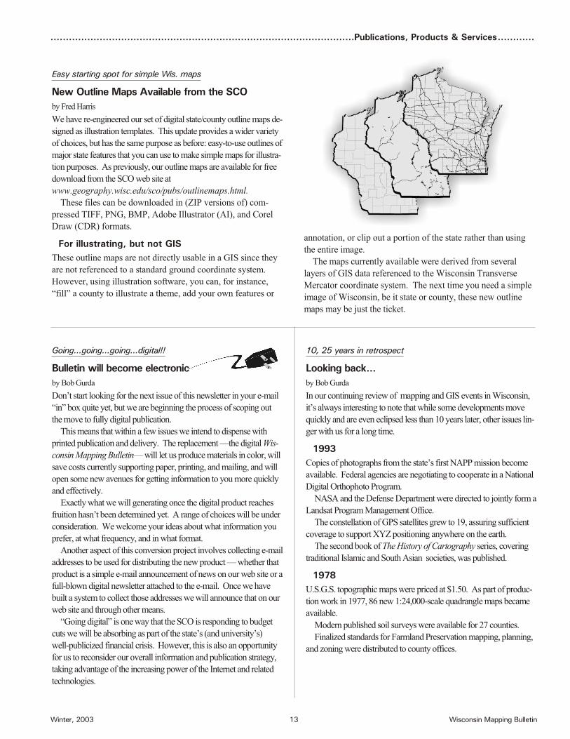
New Out line Maps Avail able from the SCO
by Fred Har ris
We have re-en gi neered our set of dig i tal state/county out line maps de -
signed as il lus tra tion tem plates. This up date pro vides a wider va ri ety
of choices, but has the same pur pose as be fore: easy-to-use out lines of
ma jor state fea tures that you can use to make sim ple maps for il lus tra -
tion pur poses. As pre vi ously, our out line maps are avail able for free
down load from the SCO web site at
www.geography.wisc.edu/sco/pubs/outlinemaps.html.
These files can be down loaded in (ZIP ver sions of) com -
pressed TIFF, PNG, BMP, Adobe Il lus tra tor (AI), and Corel
Draw (CDR) for mats.
For il lus trat ing, but not GIS
These out line maps are not di rectly us able in a GIS since they
are not ref er enced to a stan dard ground co or di nate sys tem.
How ever, us ing il lus tra tion soft ware, you can, for in stance,
“fill” a county to il lus trate a theme, add your own fea tures or
10, 25 years in ret ro spect
Look ing back...
by Bob Gurda
In our con tin u ing re view of map ping and GIS events in Wis con sin,
it’s al ways in ter est ing to note that while some de vel op ments move
quickly and are even eclipsed less than 10 years later, other is sues lin -
ger with us for a long time.
1993
Cop ies of pho to graphs from the state’s first NAPP mis sion be come
avail able. Fed eral agen cies are ne go ti at ing to co op er ate in a Na tional
Dig i tal Orthophoto Pro gram.
NASA and the De fense De part ment were di rected to jointly form a
Land sat Pro gram Man age ment Of fice.
The con stel la tion of GPS sat el lites grew to 19, as sur ing suf fi cient
cov er age to sup port XYZ po si tion ing any where on the earth.
The sec ond book of The His tory of Car tog ra phy se ries, cov er ing
tra di tional Is lamic and South Asian so ci et ies, was pub lished.
1978
U.S.G.S. top o graphic maps were priced at $1.50. As part of pro duc -
tion work in 1977, 86 new 1:24,000-scale quad ran gle maps be came
avail able.
Mod ern pub lished soil sur veys were avail able for 27 coun ties.
Fi nal ized stan dards for Farm land Pres er va tion map ping, plan ning,
and zon ing were dis trib uted to county of fices.
an no ta tion, or clip out a por tion of the state rather than us ing
the en tire im age.
The maps cur rently avail able were de rived from sev eral
lay ers of GIS data ref er enced to the Wis con sin Trans verse
Mercator co or di nate sys tem. The next time you need a sim ple
im age of Wis con sin, be it state or county, these new out line
maps may be just the ticket.

Wisconsin Mapping Bulletin 14 Winter, 2003
.............Event Reports..............................................................................................................................
Sem i nars and more
UW-Mad i son gets to gether on GIS
by Bob Gurda
Doz ens of peo ple gath ered weekly dur ing Fall se mes ter at the Uni ver -
sity of Wis con sin-Mad i son to hear pre sen ta tions in the broad field of
Geo graphic In for ma tion Sci ence. A sim i lar se ries of talks are go ing
on this Spring. These sem i nars, which are open to the pub lic, are one
ex am ple of the re vi tal iza tion of cam pus-wide GIS ac tiv i ties un der -
taken in 2002.
Speak ers in this Fall’s se ries were all fac ulty or staff from a va ri ety
of de part ments at UW-Mad i son. This Spring we in vited sev eral
speak ers from off cam pus, and be gin ning Feb. 12 are hav ing a se ries
of stu dent pre sen ta tions.. Sched ules are posted on the web site of
SIAC, the Spa tial In for ma tion and Anal y sis Con sor tium —
www.geography.wisc.edu/sco/siac/.
A va ri ety of sem i nar top ics
The Fall top ics were var ied, in clud ing:
· GIS map ping of an i mal func tions on real land scapes;
· Mea sur ing and mod el ing global land-use and land-coverchange;
· Sat el lite mon i tor ing of large lakes with NASA’s EOS;
· On-line tools for help ing non-ex perts se lect good colorschemes;
· Back-cast ing and fore cast ing res i den tial hous ing den sitythrough at trib ute clus ter ing;
· Can opy tran spi ra tion mod els & global clas si fi ca tion sys -tems as re lated to land scape wa ter flux;
· Po ten tial and prob lems for que ry ing land-use data over the web;
· De vel op ing the his tory of 20th cen tury car tog ra phy; and
· Geo graphic vi su al iza tion us ing Vis5D and VisAD.
This Spring’s fare is even more di verse, in clud ing BioMapper, GIS
in Health, or ga ni za tion is sues in lo cal gov ern ment en ter prise GIS, Wis
DOT’s GIS or ga ni za tion, meth ods for con nect ing oc cluded roads
from im ag ery, Atrizine ex po sure pat terns and can cer, de sign of ri par -
ian buffer strips, re gres sion and wave let ap proaches to pre dict ing traf -
fic pat terns, on tol ogy map ping of cat e gor i cal in for ma tion, scale in dis -
trib uted hy dro log i cal mod el ing, and spa tial data min ing of soil maps.
Pub lic lec ture on April 28
We are es pe cially pleased to an nounce plans to host a visit to
Mad i son by alum nus who has re ceived at ten tion in the main -
stream me dia for his role in help ing New York City re spond to
the 9/11 at tacks. Sean Ahearn re ceived his PhD from our En -
vi ron men tal Mon i tor ing Pro gram and is a pro fes sor at Hunter
Col lege in New York City. His GIS lab was in stru men tal in
get ting the city’s GIS sys tem back up and run ning quickly, and
in ac quir ing daily im ag ery over the World Trade Cen ter site.
Sean’s pub lic lec ture, sched uled for 4 p.m. in Room 3650 of
the Hu man i ties Build ing on April 28, will also cover his work
on track ing West Nile Vi rus as well as an a lyz ing fac tors re lated
to Ben gal Ti ger hab i tat in Ne pal.
Qual ity con tin ues to im prove
WLIA map con test a win ner for all
by Bob Gurda
At Feb ru ary’s an nual con fer ence of the Wis con sin Land In for ma tion
As so ci a tion, doz ens of mem bers en tered their maps in com pe ti tion.
Hav ing served as a judge for the last sev eral years, I can say that the
av er age level of map-mak ing skills is on the rise. The win ning maps
are ex cel lent ex am ples of what is pos si ble when at ten tion is given to
the prin ci ples of map de sign.
WLIA has sev eral cat e go ries in the com pe ti tion in or der to cover
the va ri ety of maps that peo ple may pro duce. The judg ing is car ried
out with a team for each cat e gory. Plus the mem ber ship votes for its
fa vor ite map re gard less of cat e gory, and the pres i dent se lects one map
for an ad di tional award.
The en ve lope, please
The big win ner for 2003 is Dan Seidensticker of the Mad i son
Met ro pol i tan Plan ning Or ga ni za tion. Three of his maps
earned prizes: a First Place in the The matic Map cat e gory, a
Sec ond Place in Orthophoto-based Maps, and the Pres i dent’s
Choice award. Jim Landwehr of Waukesha County came
away with the Peo ple’s Choice Award, and Andy Faust earned
both a First and Sec ond Place Award. (for Ortho-based Map,
and Map Poster, re spec tively).
Other win ners were Bill Shockley (Clark County) and Ja son
Krueger (Con ti nen tal Map ping) in the Base Map cat e gory; Lisa
Olson-Mac Don ald (Wis. Dept. of Admin.) and JoAnn Parks (W.
Cen tral Wis. RPC) in the Small-For mat cat e gory; Denis Wiese (Wis.
DNR) in the The matic Map category; Sam Batzli, Jon a than Chipman,
Tom Lillesand, and Tim Olsen (UW-Mad i son ERSC in the Map
Poster cat e gory; and Trish Nau (E. Cen tral Wis. RPC) and Matt
Guptail (N. Cen tral Wis. RPC) in the Black-and-White cat e gory.
Rais ing the bar
The size and qual ity of color print ers has had an ob vi ous af fect
on the po ten tial for pro duc ing great maps for this com pe ti tion.
How ever, that af fect is not al ways pos i tive, as in maps that
over use sat u rated col ors (while us ing up ex pen sive ink car -
tridges). The tried and true guide lines of solid map de sign ap -
ply re gard less of the print ing tech nol ogy!
More gen er ally, the maps have im proved in re cent years with more
care given to clear and ap pro pri ate ti tles, more com plete metadata,
im proved use of fig ure-ground, and more so phis ti cated se lec tion of
sym bols and graphic hi er ar chy.
Some peo ple are prob a bly plan ning al ready for their next year en -
tries. There are hints, too, that WLIA may in sti tute some new cat e go -
ries (e.g., Internet-based maps).
Steps to ward im prove ment
There will be op por tu ni ties to sharpen your map-mak ing skills
over the up com ing months. Watch for an nounce ments of
work shops, cri tique ses sions, and on-line tu to ri als.

Winter, 2003 15 Wisconsin Mapping Bulletin
...................................................................................................Up com ing Events ..................................
2003May 1, Wis con sin GITA Chap ter will spon sor a sem i nar on"GIS Tech nol ogy En abling Pub lic Works and Mu nic i pal Util i -ties" to be held at the Com fort Inn, Mad i son, WI. Con tactThomas Tym at [email protected] or call262/542-5733.
May 3-9, ASPRS An nual Con fer ence will be held at the An -chor age Con ven tion Cen ter, An chor age, AK. Visitwww.asprs.org/alaska2003.
May 19-21, GeoSpatial World will be held in New Or leans,LA. Con tact www.geospatialworld.com/.
June 15-20, The In ter na tional Con fer ence on the His tory ofCar tog ra phy will be held in Cam bridge, MA (first 3 days)con tin u ing in Port land, ME (last 3 days). Visitwww.ichc2003.org or phone 207/780-5951.
June 19-20, Wis con sin Land In for ma tion As so ci a tion mem -ber ship meet ing will be held at the Hol i day Inn in Manitowoc,WI. Con tact WLIA at 800/344-0421 or visit www.wlia.org.
June 30-July 2, Iowa's GIS Con fer ence will be held at theScheman Cen ter - Iowa State Uni ver sity, Ames, IA. Visit:http://igic.gis.iastate.edu/2003conf/2003IGIC.htm.
July 7-11, ESRI In ternational User Con fer ence will be heldin San Diego, CA. Visit www.esri.com/events/index.html.
July 24, Wis con sin Land In for ma tion As so ci a tion will spon -sor a sum mer work shop on Re mote Sens ing: Ba sics and Ap pli -ca tions that will be held at the Ho tel Mead & Con fer ence Cen -ter, Wis con sin Rap ids, WI. Con tact WLIA at 800/344-0421 orvisit www.wlia.org.
Au gust 10-16, In ter na tional Car to graphic Con fer ence and12th Gen eral As sem bly of the In ter na tional Car to graphic As -so ci a tion will be held in Durban, South Af rica. Visitwww.icc2003.gov.za/
Oc to ber 11-16, URISA 2003 An nual Con fer ence will be held in At lanta, GA. Con tact 847/824-6300 or visit www.urisa.org.
Oc to ber 16-17, Wis con sin Land In for ma tion As so ci a tionmem ber ship meet ing will be held at the House on the RockRe sort in Spring Green, WI. Con tact WLIA at 800/344-0421or visit www.wlia.org.
Oc to ber 28-30, Dig i tal Ter rain Data and 3D Vi su al iza tion,spon sored by ASPRS and MAPPS will be held in theCharleston Con ven tion Cen ter, Charleston,SC. Visitwww.asprs.org or www.mapps.org.
To see a more ex ten sive cal en dar ofre gional events, and to use hot links toother cal en dars, visit the SCO website.
Mil wau kee con fer ence is spring board
WLIA looks to next year
by Bob Gurda
Fol low ing its Feb ru ary an nual con fer ence, the
Wis con sin Land In for ma tion As so ci a tion is
fo cus ing on the up com ing months which will
cul mi nate in the 17th an nual con fer ence in
Wis con sin Dells next March 2-5.
In the in terim there will be re gional meet -
ings in Manitowoc (June 19-20) and Spring
Green (Oc to ber 16-17), at least one sum mer
work shop (July 24 in Wis. Rap ids), and ac tiv -
ity through var i ous com mit tees and task
forces.
Also of great con cern to the WLIA is
the Sep tem ber sun set fac ing the Wis.
Land In for ma tion Board and af fects of
the state’s ma jor bud get re duc tions ex pected
in the 2003-2005 bi en nium.
Awards
At each an nual con fer ence the WLIA
hon ors peo ple who have made ex em -
plary con tri bu tions to the or ga ni za tion
and to land re cords mod ern iza tion more
gen er ally. This year the key awards
went to:
· D. Da vid Moyer, State NGS Ad vi -sor: Alan H. Miller Sus tained Ser vice
· Da vid Fodroczi, St. Croix CountyPlan ning Di rec tor: Pres i den tialHonor
· Brown County, City of New Berlin,and Iowa County: Lo cal Gov ern -ment Achieve ment
· Ted Brenson, Sauk County: Out -stand ing Con tri bu tion
· Franc Fennessy,. Tom Ourada, TomSolberg, and Tom Krauskopf: Friend of Land Re cords (all be ingout go ing mem bers of the Wis. LandIn for ma tion Board, rep re sent ing state agen cies)
Elec tions
WLIA mem bers chose mem bers to serve
on the Board of Di rec tors (two-year
terms) and as of fi cers as fol lows:
· Pres i dent-elect: Alissa Bails (R.ASmith & As so ci ates, Inc.)
· Di rec tors: Ken Pabich (Cal u metCounty), Joyce Fiacco (DodgeCounty), Scott Galetka (Lin colnCounty), Alan Lulloff (Wis. DNR),and Jeff DuMez (Brown County).
· Six ad di tional board mem berselected a year ago will con tinuethrough Spring 2004. Jeff Bluske (La Crosse County) moved upfrom Pres i dent-elect to Pres i dentat the an nual meet ing.
Keep in touch
For fur ther news of WLIA events and
ini tia tives, visit www.wlia.org.

Wisconsin Mapping Bulletin 16 Winter, 2003
AD DRESS SER VICE RE QUESTED
About our Web site...Here you will find links men tioned in Bul le -
tin ar ti cles, in for ma tion on a wide range of
map ping top ics, news items, func tions and
ac tiv i ties of the SCO, our on-line ae rial pho -
tog ra phy cat a log, a cal en dar of events, and
links to re lated web sites.
www.ge og ra phy.wisc.edu/sco
About WISCLINC Web site...
On the Wis con sin Land IN for ma tion Clear -
ing house (WISCLINC) site, you can search
and read metadata files, down load cer tain
data files, learn about our con tin u ing work
in this area, and link to other state clear ing -
houses.
www.wisclinc.state.wi.us
State Car tog ra pher’s Of ficeUniv. of Wisconsin- MadisonRm. 160 Sci ence Hall550 N. Park StreetMadi son, WI 53706- 1491
Non profit Or ga ni za tion
U. S. POST AGE
PAID
Mad i son, Wis con sin
Per mit No. 658
About the SCO...The State Car tog ra pher’s Of fice (SCO), es tab lished in 1973, is a unit of the Uni ver sity of
Wis con sin-Mad i son. The SCO is lo cated on the 1st Floor of Sci ence Hall.
Our per ma nent staff con sists of five peo ple—Ted Koch, State Car tog ra pher
(608/262-6852), Bob Gurda, As sis tant State Car tog ra pher (608/262-6850), A.J. Wortley,
Out reach Spe cial ist (608/265-8106), Brenda Hemstead, IS Re source Sup port Tech ni cian
(608/263-4371), and Ana Rumm, Fi nan cial Spe cial ist (608/265-9368). We also em ploy
sev eral part-time grad u ate and un der grad u ate stu dents.
The State Car tog ra pher’s po si tion and mis sion are de scribed in Wis. Stat ute 32.25
(12m). In ad dress ing this role, the SCO func tions in a num ber of ways.
· pub lishes the Wis con sin Map ping Bul le tin, cat a logs, guides, bro chures, and otherdoc u ments and main tains a web site to in form the map ping com mu nity.
· in ven to ries map ping prac tices, meth ods, ac com plish ments, ex pe ri ence, and ex per -tise, and fur ther acts as a clear ing house by pro vid ing in for ma tion and ad vice insup port of sound map ping prac tices and map use.
· par tic i pates on com mit tees, task forces, boards, etc. The State Car tog ra pher is one of the 13 vot ing mem bers of the Wis con sin Land In for ma tion Board and one of 16vot ing mem bers on the Wis con sin Land Coun cil.
· de vel ops ex per i men tal and pro to type prod ucts.
· serves as the state’s af fil i ate for car to graphic in for ma tion in the U.S. Geo log i calSur vey’s Earth Sci ence In for ma tion Cen ter (ESIC) net work.
Wis con sinMap ping Bul le tin
Published quarterly by the Wisconsin StateCartographer’s Office. A University ofWisconsin-Madison outreach publicationdistributed free upon request.
News is wel come on com pleted or on go ing pro jects, pub lished maps or re ports, or con fer ences/work shops. Lo cal and re gional in for ma tion ises pe cially en cour aged. The ed i tor makes allde ci sions on con tent. Dead line for the next is sue isMay 15, 2003.
Editor: Bob GurdaIllustrations: Brenda Hemstead, Bonner Karger,Kevin White, and Adam SimcockDesktop publishing: Brenda HemsteadPrinting: UW-Printing ServicesMailing: UW-Extension Bulk Mail
Please send all comments, corrections, and newsitems to:
State Cartographer’s OfficeRoom 160 Science Hall550 N. Park StreetMadison, WI 53706-1491phone: 608/262-3065fax: 608/262-5205email: [email protected]