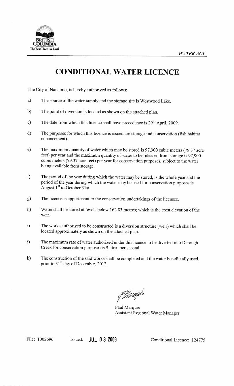
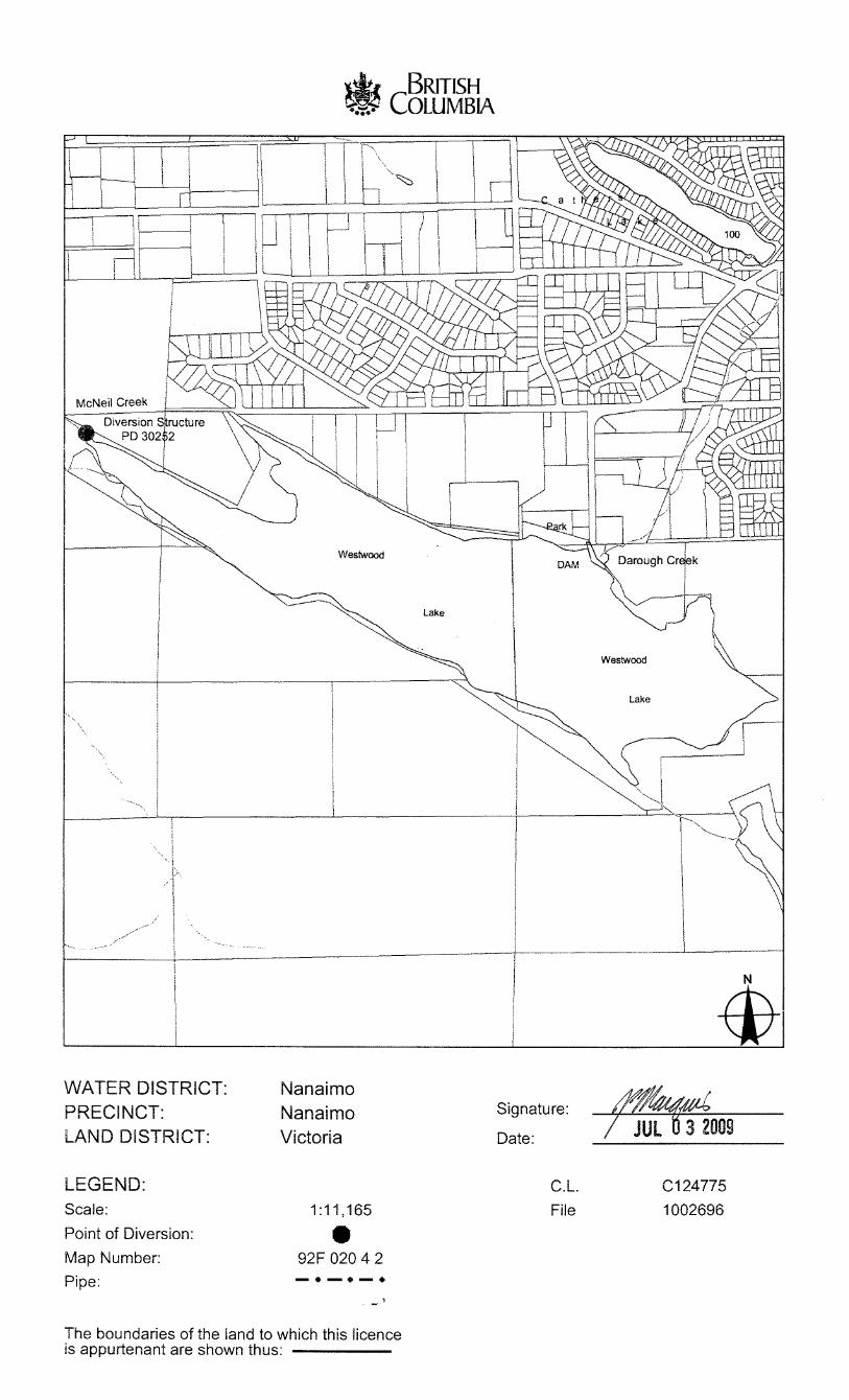
Westwood Lake Storage Development...
39
1 Westwood Lake Storage Development Phase II Design and Construction Report Prepared For: Habitat Conservation Trust Foundation (CAT10-1-450) Living Rivers-Georgia Basin/Vancouver Island (#111081) Fisheries and Oceans Canada Prepared By: R. Powley September 2009
Transcript of Westwood Lake Storage Development...
1
Westwood Lake Storage Development Phase II
Design and Construction Report
Prepared For: Habitat Conservation Trust Foundation (CAT10-1-450) Living Rivers-Georgia Basin/Vancouver Island (#111081) Fisheries and Oceans Canada
Prepared By: R. Powley September 2009

i
TABLE OF CONTENTS Background/Introduction 1 Regulatory Approvals 1 Construction 4 Construction Photos 5
1
WESTWOOD LAKE STORAGE DEVELOPMENT PHASE II DESIGN & CONSTRUCTION REPORT
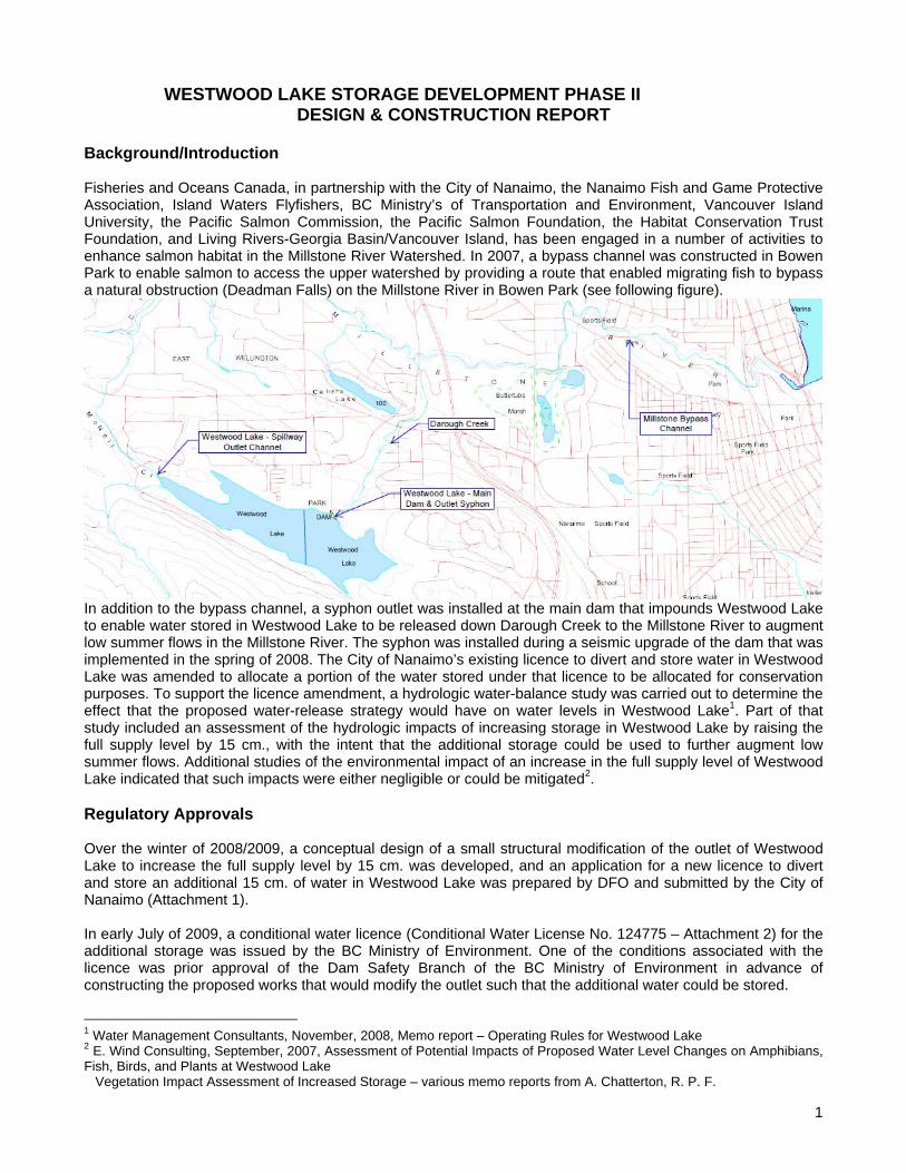
Background/Introduction Fisheries and Oceans Canada, in partnership with the City of Nanaimo, the Nanaimo Fish and Game Protective Association, Island Waters Flyfishers, BC Ministry’s of Transportation and Environment, Vancouver Island University, the Pacific Salmon Commission, the Pacific Salmon Foundation, the Habitat Conservation Trust Foundation, and Living Rivers-Georgia Basin/Vancouver Island, has been engaged in a number of activities to enhance salmon habitat in the Millstone River Watershed. In 2007, a bypass channel was constructed in Bowen Park to enable salmon to access the upper watershed by providing a route that enabled migrating fish to bypass a natural obstruction (Deadman Falls) on the Millstone River in Bowen Park (see following figure).
In addition to the bypass channel, a syphon outlet was installed at the main dam that impounds Westwood Lake to enable water stored in Westwood Lake to be released down Darough Creek to the Millstone River to augment low summer flows in the Millstone River. The syphon was installed during a seismic upgrade of the dam that was implemented in the spring of 2008. The City of Nanaimo’s existing licence to divert and store water in Westwood Lake was amended to allocate a portion of the water stored under that licence to be allocated for conservation purposes. To support the licence amendment, a hydrologic water-balance study was carried out to determine the effect that the proposed water-release strategy would have on water levels in Westwood Lake1. Part of that study included an assessment of the hydrologic impacts of increasing storage in Westwood Lake by raising the full supply level by 15 cm., with the intent that the additional storage could be used to further augment low summer flows. Additional studies of the environmental impact of an increase in the full supply level of Westwood Lake indicated that such impacts were either negligible or could be mitigated2. Regulatory Approvals Over the winter of 2008/2009, a conceptual design of a small structural modification of the outlet of Westwood Lake to increase the full supply level by 15 cm. was developed, and an application for a new licence to divert and store an additional 15 cm. of water in Westwood Lake was prepared by DFO and submitted by the City of Nanaimo (Attachment 1). In early July of 2009, a conditional water licence (Conditional Water License No. 124775 – Attachment 2) for the additional storage was issued by the BC Ministry of Environment. One of the conditions associated with the licence was prior approval of the Dam Safety Branch of the BC Ministry of Environment in advance of constructing the proposed works that would modify the outlet such that the additional water could be stored.
1 Water Management Consultants, November, 2008, Memo report – Operating Rules for Westwood Lake 2 E. Wind Consulting, September, 2007, Assessment of Potential Impacts of Proposed Water Level Changes on Amphibians, Fish, Birds, and Plants at Westwood Lake Vegetation Impact Assessment of Increased Storage – various memo reports from A. Chatterton, R. P. F.
2
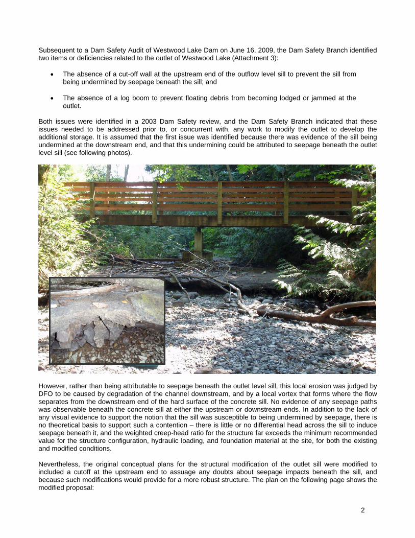
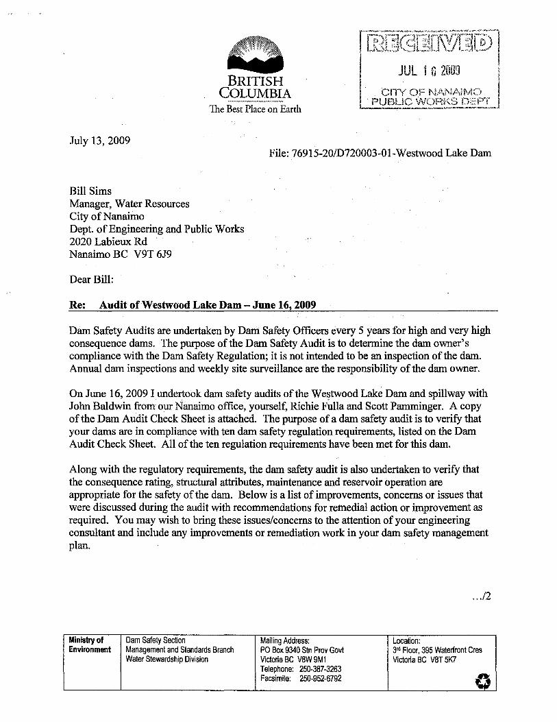
Subsequent to a Dam Safety Audit of Westwood Lake Dam on June 16, 2009, the Dam Safety Branch identified two items or deficiencies related to the outlet of Westwood Lake (Attachment 3):
The absence of a cut-off wall at the upstream end of the outflow level sill to prevent the sill from being undermined by seepage beneath the sill; and
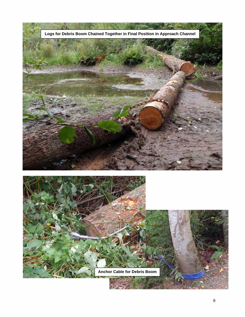
The absence of a log boom to prevent floating debris from becoming lodged or jammed at the
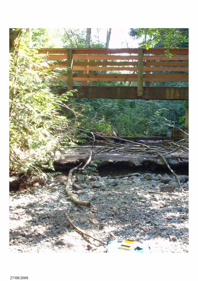
outlet. Both issues were identified in a 2003 Dam Safety review, and the Dam Safety Branch indicated that these issues needed to be addressed prior to, or concurrent with, any work to modify the outlet to develop the additional storage. It is assumed that the first issue was identified because there was evidence of the sill being undermined at the downstream end, and that this undermining could be attributed to seepage beneath the outlet level sill (see following photos).
However, rather than being attributable to seepage beneath the outlet level sill, this local erosion was judged by DFO to be caused by degradation of the channel downstream, and by a local vortex that forms where the flow separates from the downstream end of the hard surface of the concrete sill. No evidence of any seepage paths was observable beneath the concrete sill at either the upstream or downstream ends. In addition to the lack of any visual evidence to support the notion that the sill was susceptible to being undermined by seepage, there is no theoretical basis to support such a contention – there is little or no differential head across the sill to induce seepage beneath it, and the weighted creep-head ratio for the structure far exceeds the minimum recommended value for the structure configuration, hydraulic loading, and foundation material at the site, for both the existing and modified conditions. Nevertheless, the original conceptual plans for the structural modification of the outlet sill were modified to included a cutoff at the upstream end to assuage any doubts about seepage impacts beneath the sill, and because such modifications would provide for a more robust structure. The plan on the following page shows the modified proposal:

3
4
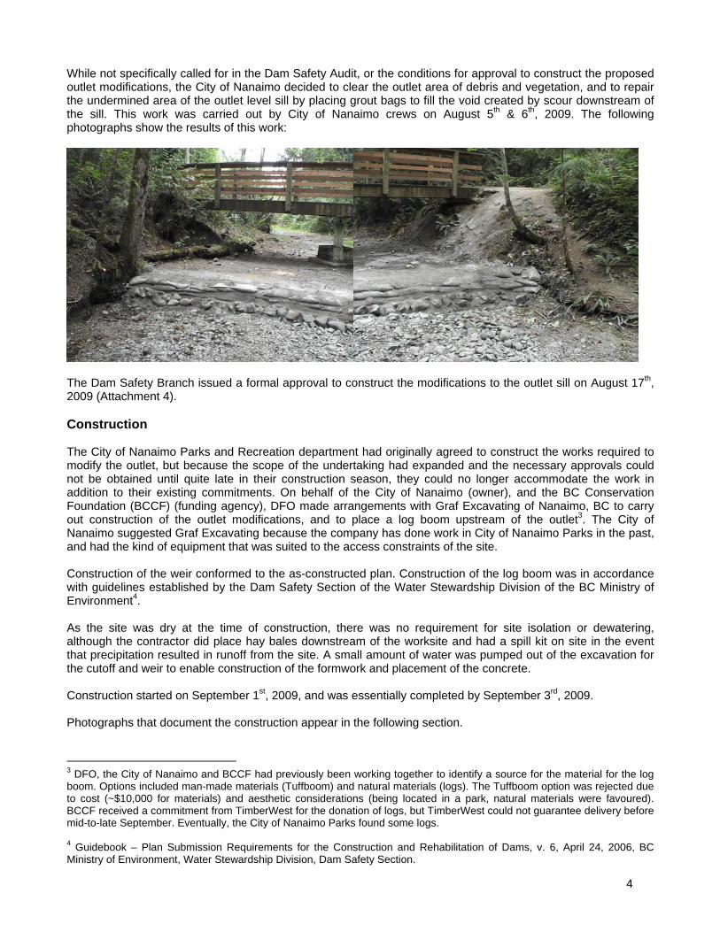
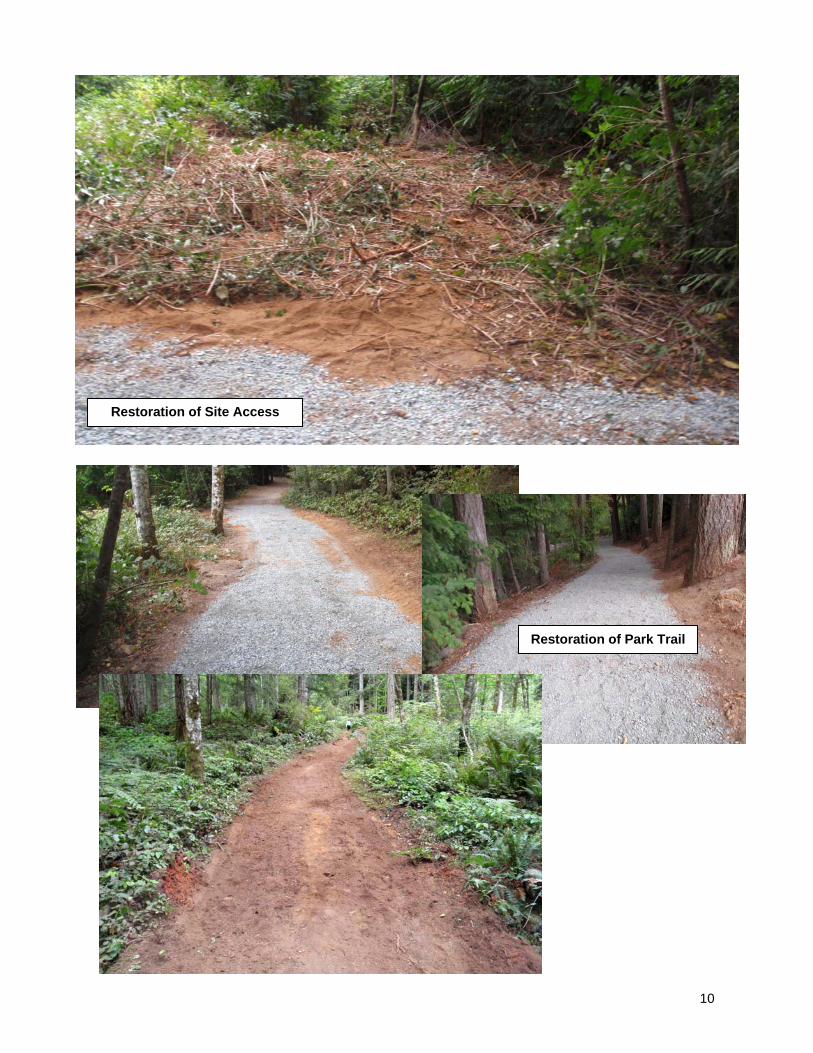
While not specifically called for in the Dam Safety Audit, or the conditions for approval to construct the proposed outlet modifications, the City of Nanaimo decided to clear the outlet area of debris and vegetation, and to repair the undermined area of the outlet level sill by placing grout bags to fill the void created by scour downstream of the sill. This work was carried out by City of Nanaimo crews on August 5th & 6th, 2009. The following photographs show the results of this work:
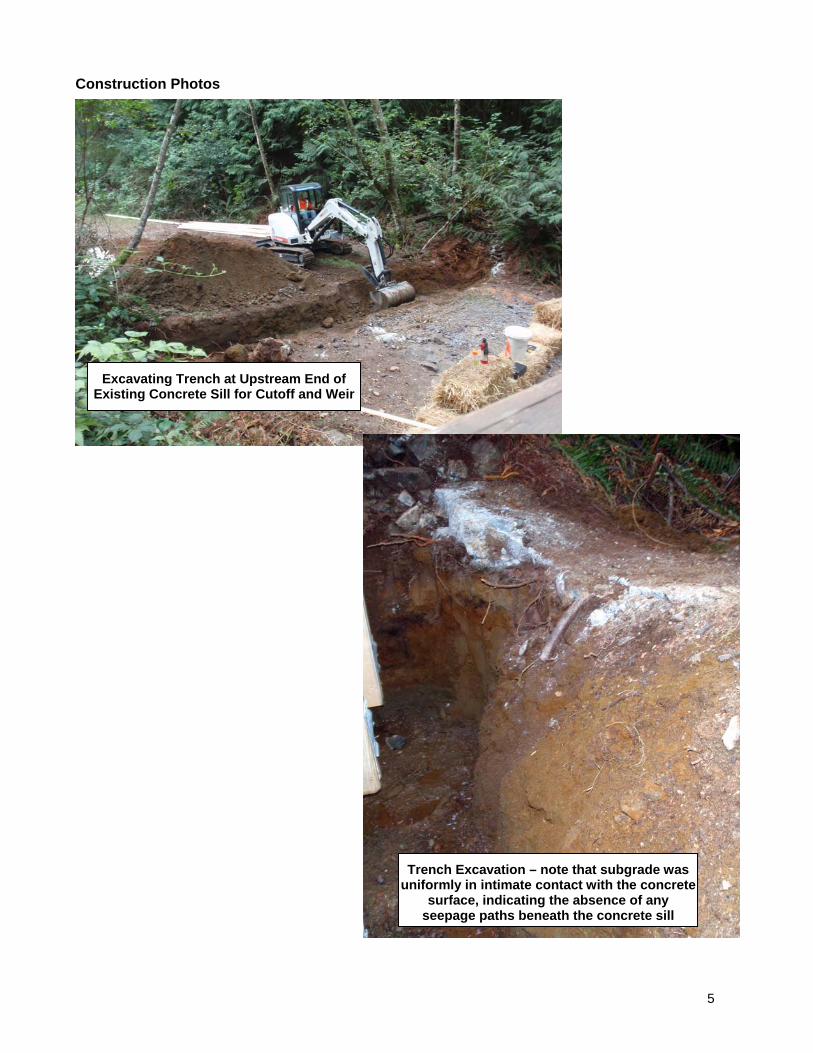
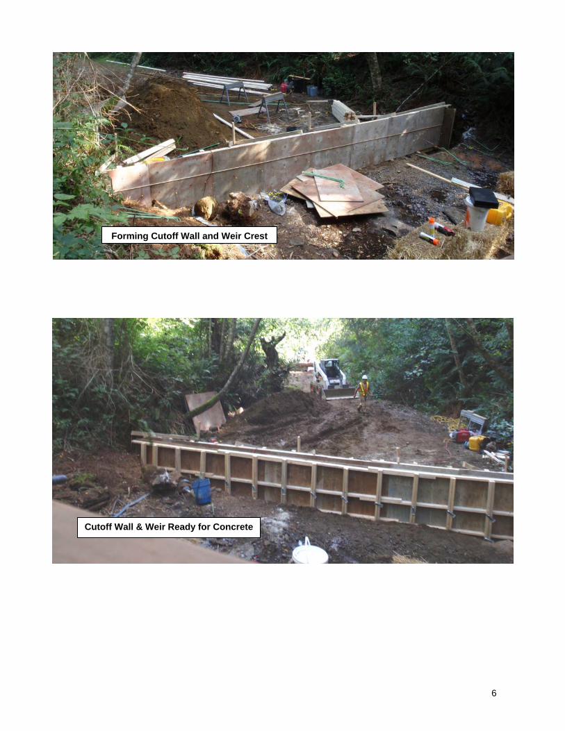
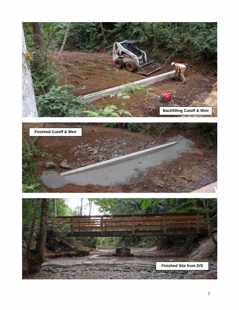
The Dam Safety Branch issued a formal approval to construct the modifications to the outlet sill on August 17th, 2009 (Attachment 4). Construction The City of Nanaimo Parks and Recreation department had originally agreed to construct the works required to modify the outlet, but because the scope of the undertaking had expanded and the necessary approvals could not be obtained until quite late in their construction season, they could no longer accommodate the work in addition to their existing commitments. On behalf of the City of Nanaimo (owner), and the BC Conservation Foundation (BCCF) (funding agency), DFO made arrangements with Graf Excavating of Nanaimo, BC to carry out construction of the outlet modifications, and to place a log boom upstream of the outlet3. The City of Nanaimo suggested Graf Excavating because the company has done work in City of Nanaimo Parks in the past, and had the kind of equipment that was suited to the access constraints of the site. Construction of the weir conformed to the as-constructed plan. Construction of the log boom was in accordance with guidelines established by the Dam Safety Section of the Water Stewardship Division of the BC Ministry of Environment4. As the site was dry at the time of construction, there was no requirement for site isolation or dewatering, although the contractor did place hay bales downstream of the worksite and had a spill kit on site in the event that precipitation resulted in runoff from the site. A small amount of water was pumped out of the excavation for the cutoff and weir to enable construction of the formwork and placement of the concrete. Construction started on September 1st, 2009, and was essentially completed by September 3rd, 2009. Photographs that document the construction appear in the following section.
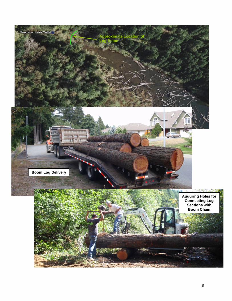
3 DFO, the City of Nanaimo and BCCF had previously been working together to identify a source for the material for the log boom. Options included man-made materials (Tuffboom) and natural materials (logs). The Tuffboom option was rejected due to cost (~$10,000 for materials) and aesthetic considerations (being located in a park, natural materials were favoured). BCCF received a commitment from TimberWest for the donation of logs, but TimberWest could not guarantee delivery before mid-to-late September. Eventually, the City of Nanaimo Parks found some logs. 4 Guidebook – Plan Submission Requirements for the Construction and Rehabilitation of Dams, v. 6, April 24, 2006, BC Ministry of Environment, Water Stewardship Division, Dam Safety Section.
5
Construction Photos
Excavating Trench at Upstream End of Existing Concrete Sill for Cutoff and Weir
Trench Excavation – note that subgrade was uniformly in intimate contact with the concrete
surface, indicating the absence of any seepage paths beneath the concrete sill
6
Forming Cutoff Wall and Weir Crest
Cutoff Wall & Weir Ready for Concrete
7
Backfilling Cutoff & Weir
Finished Cutoff & Weir
Finished Site from D/S
8
Approximate Location of Log Boom
Boom Log Delivery
Auguring Holes for Connecting Log
Sections with Boom Chain
9
Logs for Debris Boom Chained Together in Final Position in Approach Channel
Anchor Cable for Debris Boom
10
Restoration of Site Access
Restoration of Park Trail
11
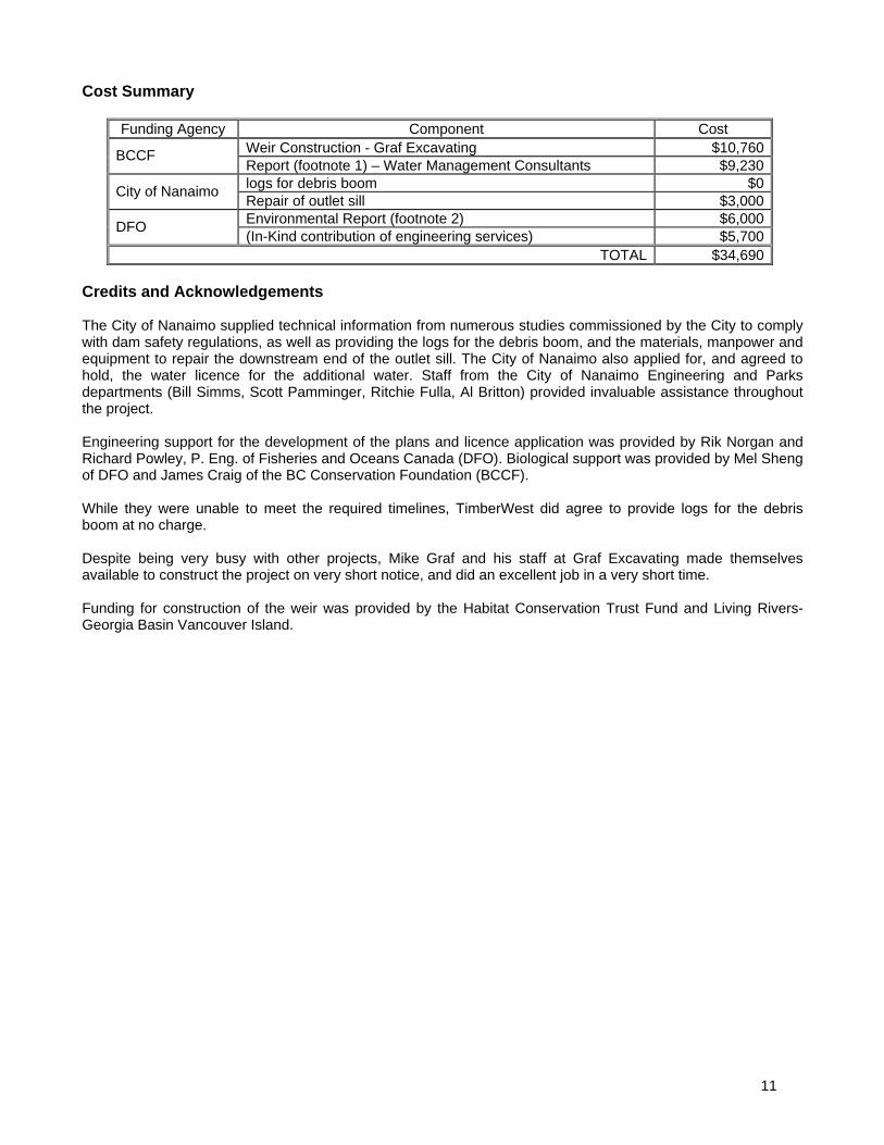
Cost Summary
Funding Agency Component Cost Weir Construction - Graf Excavating $10,760BCCF Report (footnote 1) – Water Management Consultants $9,230logs for debris boom $0
City of Nanaimo Repair of outlet sill $3,000Environmental Report (footnote 2) $6,000
DFO (In-Kind contribution of engineering services) $5,700
TOTAL $34,690 Credits and Acknowledgements The City of Nanaimo supplied technical information from numerous studies commissioned by the City to comply with dam safety regulations, as well as providing the logs for the debris boom, and the materials, manpower and equipment to repair the downstream end of the outlet sill. The City of Nanaimo also applied for, and agreed to hold, the water licence for the additional water. Staff from the City of Nanaimo Engineering and Parks departments (Bill Simms, Scott Pamminger, Ritchie Fulla, Al Britton) provided invaluable assistance throughout the project. Engineering support for the development of the plans and licence application was provided by Rik Norgan and Richard Powley, P. Eng. of Fisheries and Oceans Canada (DFO). Biological support was provided by Mel Sheng of DFO and James Craig of the BC Conservation Foundation (BCCF). While they were unable to meet the required timelines, TimberWest did agree to provide logs for the debris boom at no charge. Despite being very busy with other projects, Mike Graf and his staff at Graf Excavating made themselves available to construct the project on very short notice, and did an excellent job in a very short time. Funding for construction of the weir was provided by the Habitat Conservation Trust Fund and Living Rivers-Georgia Basin Vancouver Island.

ATTACHMENT 1
MEMORANDUM NOTE DE SERVICE
To À
Scott Pamminger Water Resources Technologist City of Nanaimo Public Works Yard, 2020 Labieux Road Nanaimo, BC V9T 6J9
From De
Richard Powley Resource Restoration Engineer Fisheries and Oceans Canada Resource Restoration 1965 Island Diesel Way Nanaimo, BC V9S 5W8
Security Classification - Classification de sécurité
UNCLASSIFIED
Our file - Notre référence
N/A
Your File - Votre référence
N/A
Date
April 16th, 2009
Subject Object
WESTWOOD LAKE - LICENCING FOR ADDITIONAL STORAGE
With respect to plans to create additional storage in Westwood lake by installing a fixed control structure at the entrance to the existing excavated channel that acts as a spillway for Westwood Lake, I have made some inquiries and it appears as though licencing for the additional storage would require an application for a new licence, rather than just an amendment to the existing licence. To that end, I have endeavored to determine the information required for an application for a new licence. I received some guidance from David Weir (Ministry of Environment, Water Stewardship) regarding the information required to support such an application, and he informed me that the following information would be required:
The volume of additional storage; The area of land that would be flooded by creating the additional storage; How the creation of the additional storage would affect the flood-passage capability of
Westwood Lake, for dam safety purposes. Additional Storage and Flooded Area To address the first two points requires that information relating to how the storage volume and flooded area of Westwood Lake are related to water levels in the lake. This information is partially provided by the sonar profiling survey carried out by AquaCoustic Remote Technologies Inc. for the City of Nanaimo in 2003. However, the information in that report is only applicable to lake levels up to and including the lake level on the day of the survey (El. 161.8 m), which is lower than the existing Full Supply Level (FSL) of the lake determined by the elevation of the excavated channel at the north end of the lake that acts as the spillway for the reservoir. Based on a survey of the lake outlet, the FSL for Westwood Lake is about 162.68 m (see following drawing and photograph).
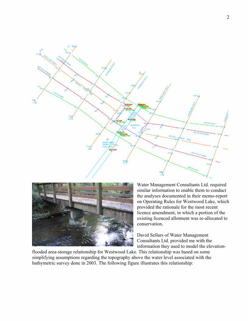
2
Water Management Consultants Ltd. required similar information to enable them to conduct the analyses documented in their memo-report on Operating Rules for Westwood Lake, which provided the rationale for the most recent licence amendment, in which a portion of the existing licenced allotment was re-allocated to conservation.
David Sellars of Water Management Consultants Ltd. provided me with the information they used to model the elevation-
flooded area-storage relationship for Westwood Lake. This relationship was based on some simplifying assumptions regarding the topography above the water level associated with the bathymetric survey done in 2003. The following figure illustrates this relationship:
3
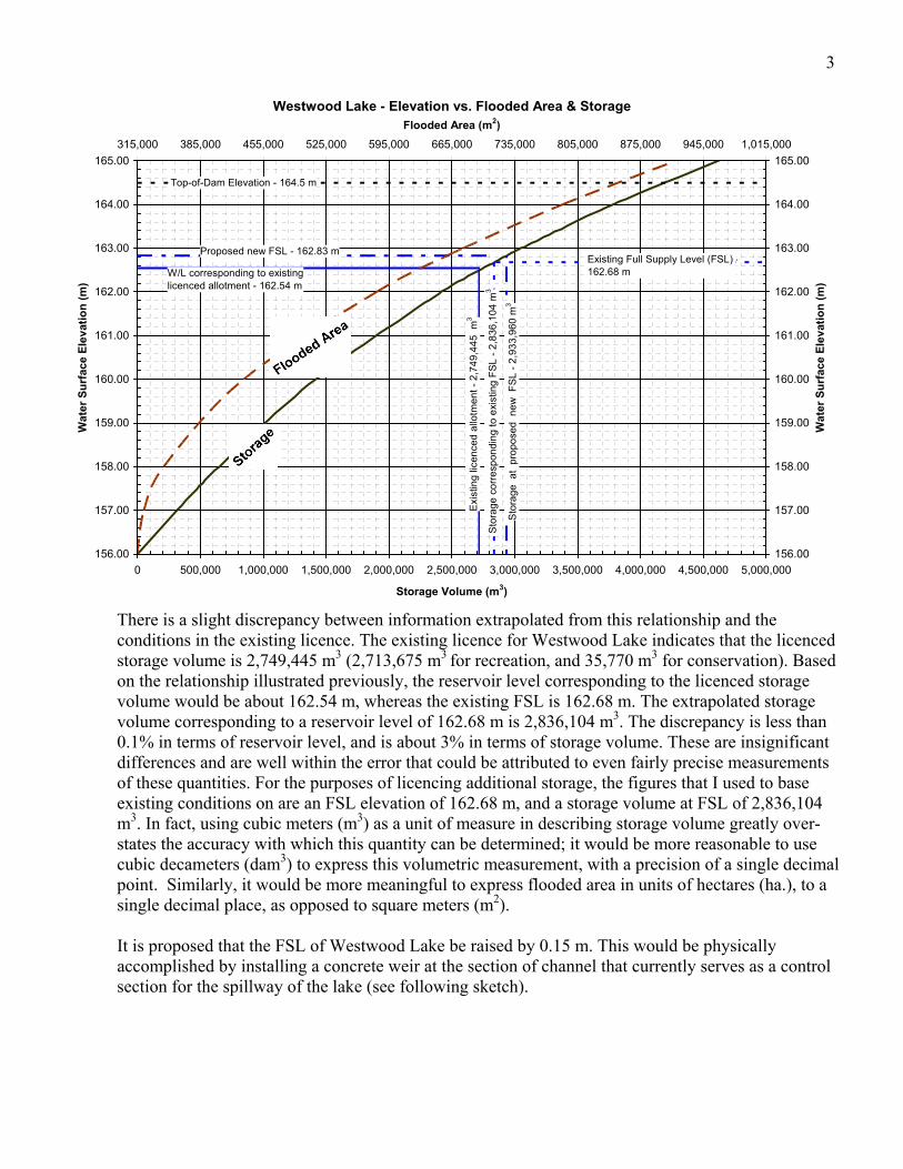
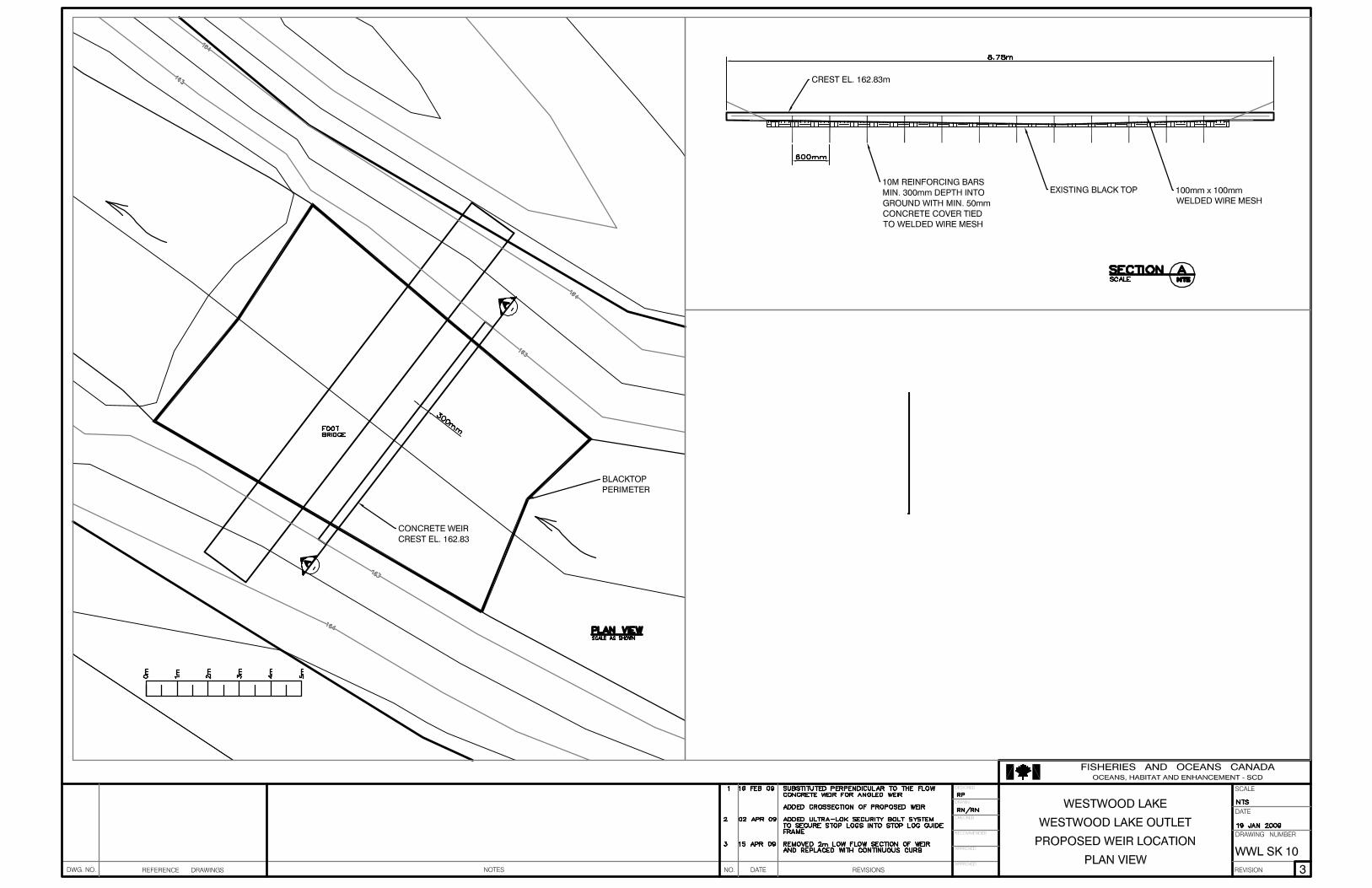
There is a slight discrepancy between information extrapolated from this relationship and the conditions in the existing licence. The existing licence for Westwood Lake indicates that the licenced storage volume is 2,749,445 m3 (2,713,675 m3 for recreation, and 35,770 m3 for conservation). Based on the relationship illustrated previously, the reservoir level corresponding to the licenced storage volume would be about 162.54 m, whereas the existing FSL is 162.68 m. The extrapolated storage volume corresponding to a reservoir level of 162.68 m is 2,836,104 m3. The discrepancy is less than 0.1% in terms of reservoir level, and is about 3% in terms of storage volume. These are insignificant differences and are well within the error that could be attributed to even fairly precise measurements of these quantities. For the purposes of licencing additional storage, the figures that I used to base existing conditions on are an FSL elevation of 162.68 m, and a storage volume at FSL of 2,836,104 m3. In fact, using cubic meters (m3) as a unit of measure in describing storage volume greatly over-states the accuracy with which this quantity can be determined; it would be more reasonable to use cubic decameters (dam3) to express this volumetric measurement, with a precision of a single decimal point. Similarly, it would be more meaningful to express flooded area in units of hectares (ha.), to a single decimal place, as opposed to square meters (m2). It is proposed that the FSL of Westwood Lake be raised by 0.15 m. This would be physically accomplished by installing a concrete weir at the section of channel that currently serves as a control section for the spillway of the lake (see following sketch).
Westwood Lake - Elevation vs. Flooded Area & Storage
Top-of-Dam Elevation - 164.5 m
W/L corresponding to existing licenced allotment - 162.54 m
Existing Full Supply Level (FSL) -162.68 m
Proposed new FSL - 162.83 m
Exi
stin
g lic
ence
d a
llotm
ent
- 2
,74
9,4
45 m
3
Sto
rage
co
rres
pon
din
g to
exi
stin
g F
SL
- 2
,836
,10
4 m
3
Sto
rage
at
pro
pose
d n
ew F
SL
- 2
,93
3,9
60 m
3
156.00
157.00
158.00
159.00
160.00
161.00
162.00
163.00
164.00
165.00
0 500,000 1,000,000 1,500,000 2,000,000 2,500,000 3,000,000 3,500,000 4,000,000 4,500,000 5,000,000
Storage Volume (m3)
Wat
er S
urf
ace
Ele
vat
ion
(m
)
156.00
157.00
158.00
159.00
160.00
161.00
162.00
163.00
164.00
165.00
315,000 385,000 455,000 525,000 595,000 665,000 735,000 805,000 875,000 945,000 1,015,000
Flooded Area (m2)
Wat
er S
urf
ace
Ele
vat
ion
(m
)
4
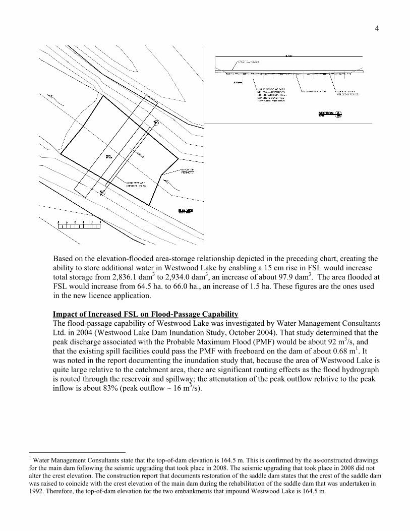
Based on the elevation-flooded area-storage relationship depicted in the preceding chart, creating the ability to store additional water in Westwood Lake by enabling a 15 cm rise in FSL would increase total storage from 2,836.1 dam3 to 2,934.0 dam3, an increase of about 97.9 dam3. The area flooded at FSL would increase from 64.5 ha. to 66.0 ha., an increase of 1.5 ha. These figures are the ones used in the new licence application. Impact of Increased FSL on Flood-Passage Capability The flood-passage capability of Westwood Lake was investigated by Water Management Consultants Ltd. in 2004 (Westwood Lake Dam Inundation Study, October 2004). That study determined that the peak discharge associated with the Probable Maximum Flood (PMF) would be about 92 m3/s, and that the existing spill facilities could pass the PMF with freeboard on the dam of about 0.68 m1. It was noted in the report documenting the inundation study that, because the area of Westwood Lake is quite large relative to the catchment area, there are significant routing effects as the flood hydrograph is routed through the reservoir and spillway; the attenutation of the peak outflow relative to the peak inflow is about 83% (peak outflow ~ 16 m3/s).
1 Water Management Consultants state that the top-of-dam elevation is 164.5 m. This is confirmed by the as-constructed drawings for the main dam following the seismic upgrading that took place in 2008. The seismic upgrading that took place in 2008 did not alter the crest elevation. The construction report that documents restoration of the saddle dam states that the crest of the saddle dam was raised to coincide with the crest elevation of the main dam during the rehabilitation of the saddle dam that was undertaken in 1992. Therefore, the top-of-dam elevation for the two embankments that impound Westwood Lake is 164.5 m.
5
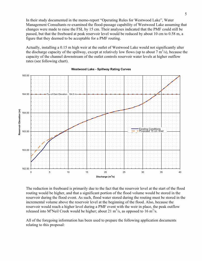
In their study documented in the memo-report “Operating Rules for Westwood Lake”, Water Management Consultants re-examined the flood-passage capability of Westwood Lake assuming that changes were made to raise the FSL by 15 cm. Their analyses indicated that the PMF could still be passed, but that the freeboard at peak reservoir level would be reduced by about 10 cm to 0.58 m, a figure that they deemed to be acceptable for a PMF routing. Actually, installing a 0.15 m high weir at the outlet of Westwood Lake would not significantly alter the discharge capacity of the spillway, except at relatively low flows (up to about 7 m3/s), because the capacity of the channel downstream of the outlet controls reservoir water levels at higher outflow rates (see following chart).
The reduction in freeboard is primarily due to the fact that the reservoir level at the start of the flood routing would be higher, and that a significant portion of the flood volume would be stored in the reservoir during the flood event. As such, flood water stored during the routing must be stored in the incremental volume above the reservoir level at the beginning of the flood. Also, because the reservoir would reach a higher level during a PMF event with the weir in place, the peak outflow released into McNeil Creek would be higher; about 21 m3/s, as opposed to 16 m3/s. All of the foregoing information has been used to prepare the following application documents relating to this proposal:
Westwood Lake - Spillway Rating Curves
Top-of-Dam Elevation - 164.5 m
162.50
163.00
163.50
164.00
164.50
165.00
0 5 10 15 20 25 30 35 40
Discharge (m3/s)
Res
ervo
ir E
leva
tio
n (
m)
Existing ConditionsProposed 15 cm WeirSeries3
6
Water Licence Application – required because the additional water stored by raising the FSL of Westwood Lake would be a new licence;
Schedule 2 – Dam and Reservoir Information – required in support of a water licence application for storage purposes.
Application for a Change of Works on a Water Licence – assumed to be required due to the fact that the existing spillway control section is to be modified.
Copies of these documents are attached. Copies of the reports by Water Management Consultants referred to in this memo should also accompany the licence application. If you have any questions, feel free to contact me at (250) 754-0340 or [email protected]. Richard Powley, P. Eng. Resource Restoration Engineer
Fisheries and Oceans Canada
Page 1 of 3
Applying for a Water Licence
Updated February 2008
THIS PAGE MUST BE COMPLETED FOR ALL APPLICATIONS.
PLEASE READ THE APPLICATION FORM GUIDE WHEN COMPLETING THIS APPLICATION.
PART 1. NAME(S) AND MAILING ADDRESS
For applications made by more than one individual:
Joint Tenants; or,
Tenants in Common
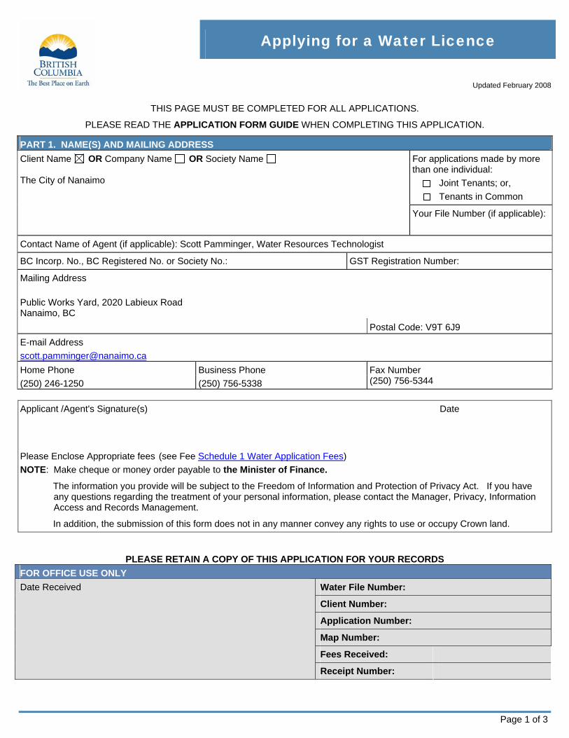
Client Name OR Company Name OR Society Name The City of Nanaimo
Your File Number (if applicable):
Contact Name of Agent (if applicable): Scott Pamminger, Water Resources Technologist
BC Incorp. No., BC Registered No. or Society No.: GST Registration Number:
Mailing Address
Public Works Yard, 2020 Labieux Road Nanaimo, BC
Postal Code: V9T 6J9
E-mail Address
Home Phone Business Phone Fax Number
(250) 246-1250 (250) 756-5338 (250) 756-5344
Applicant /Agent's Signature(s)
Date
Please Enclose Appropriate fees (see Fee Schedule 1 Water Application Fees)
NOTE: Make cheque or money order payable to the Minister of Finance.
The information you provide will be subject to the Freedom of Information and Protection of Privacy Act. If you have any questions regarding the treatment of your personal information, please contact the Manager, Privacy, Information Access and Records Management.
In addition, the submission of this form does not in any manner convey any rights to use or occupy Crown land.
PLEASE RETAIN A COPY OF THIS APPLICATION FOR YOUR RECORDS
FOR OFFICE USE ONLY
Water File Number:
Client Number:
Application Number:
Map Number:
Fees Received:
Date Received
Receipt Number:
Page 2 of 3
Applying for a Water Licence – Water Act
NOTE: Once you have completed this form, please refer to the Application Completeness Checklist for additional information that must be submitted with
this application.
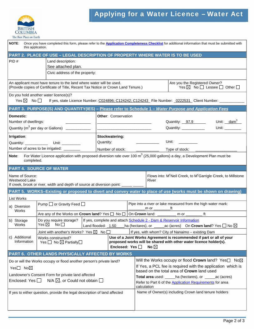
PART 2. PLACE OF USE – LEGAL DESCRIPTION OF PROPERTY WHERE WATER IS TO BE USED
Land description:
See attached plan. PID #
Civic address of the property:
An applicant must have tenure to the land where water will be used. (Provide copies of Certificate of Title, Recent Tax Notice or Crown Land Tenure.)
Are you the Registered Owner? Yes No Lessee Other
Do you hold another water licence(s)? Yes No If yes, state Licence Number: C024896; C124242; C124243_ File Number: _0222531_ Client Number: ____________
PART 3. PURPOSE(S) AND QUANTITY(IES) – Please refer to Schedule 1 – Water Purpose and Application Fees
Domestic: Other: Conservation
Number of dwellings: ____________ __________________________ Quantity: __97.9______ Unit: __dam3__
Quantity (m3 per day or Gallons) ____________ __________________________ Quantity: ___________ Unit: ________
Stockwatering:
Quantity: ___________ Unit: _________ Irrigation:
Quantity: ___________ Unit: _________
Number of acres to be irrigated: ________ Number of stock: ___________ Type of stock: ____________________
Note: For Water Licence application with proposed diversion rate over 100 m3 (25,000 gallons) a day, a Development Plan must be completed.
PART 4. SOURCE OF WATER
Name of Source: Westwood Lake If creek, brook or river, width and depth of source at diversion point: _____ _____
Flows into: McNeil Creek, to McGarrigle Creek, to Millstone River
PART 5. WORKS–Existing or proposed to divert and convey water to place of use (works must be shown on drawing)
List Works
Pump or Gravity Feed Pipe into a river or lake measured from the high water mark: ________m or ________ft a) Diversion
Works Are any of the Works on Crown land? Yes No On Crown land: _________ m or ________ ft
b) Storage Works
Do you require storage? Yes No
If yes, complete and attach Schedule 2 - Dam & Reservoir Information
Land flooded: _1.50____ha (hectares), or _____ac (acres) On Crown land? Yes No
Joint with another's Works? Yes No If yes, with whom? City of Nanaimo – existing Dam c) Additional
Information Works constructed? Yes No Partially
Use of a Joint Works Agreement is recommended if part or all of your proposed works will be shared with other water licence holder(s). Enclosed: Yes No
PART 6. OTHER LANDS PHYSICALLY AFFECTED BY WORKS
Do or will the Works occupy or flood another person's private land?
Yes No
Landowner's Consent Form for private land affected
Enclosed: Yes N/A , or Could not obtain
Will the Works occupy or flood Crown land? Yes No
If Yes, a PCL fee is required with the application which is based on the total area of Crown land used Total area used: _____ha (hectares), or _____ac (acres)
Refer to Part 6 of the Application Requirements for area calculation
If yes to either question, provide the legal description of land affected Name of Owner(s) including Crown land tenure holders
Page 3 of 3
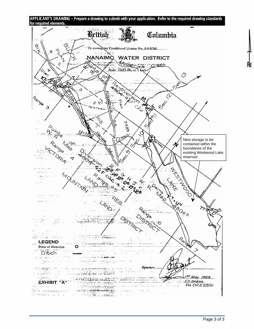
APPLICANT'S DRAWING – Prepare a drawing to submit with your application. Refer to the required drawing standards for required elements.
New storage to be contained within the boundaries of the existing Westwood Lake reservoir.

SCHEDULE 2 DAM & RESERVOIR INFORMATION
Updated July 2007
REQUIRED IN SUPPORT OF A WATER LICENCE APPLICATION FOR STORAGE PURPOSE
1. WATER LICENCE APPLICATION INFORMATION FOR OFFICE USE ONLY
SURNAME City of Nanaimo Att’n: Scott Pamminger, Water Resources
Technologist
GIVEN NAME(S)
MAILING ADDRESS Public Works Yard, 2020 Labieux Road
Nanaimo, BC POSTAL CODE
E-MAIL ADDRESS [email protected] V9T 6J9
Date Received
HOME PHONE BUSINESS PHONE FAX
(250) 246-1250 (250) 756-5338 (250) 756-5344 FILE NUMBER
SOURCE(S) OF WATER (NAME OF STREAM WHERE WORKS ARE TO BE CONSTRUCTED)
Westwood Lake (outlet)
PROJECT CONSULTANT
This is an existing dam. Analyses relating to the support of this application were conducted by:
Water Management Consultants Ltd. and
Fisheries and Oceans Canada
◄ The Water Stewardship Division may recommend that the dam be designed by, and constructed under the supervision of, a Professional Engineer registered in the province of BC.
MAILING ADDRESS
Water Management Consultants Ltd. Fisheries and Oceans Canada, Resource Restoration
130-10691 Shellbridge Way 1965 Island Diesel Way
Richmond, BC V6X 2W8 Nanaimo, BC V9S 5W8
Ph. (604) 273-6299 Ph. (250) 754-0340
POSTAL CODE PHONE FAX
2. PROPOSED WORKS – Please Complete 1 or 2 where applicable to your project.
IS THE DUGOUT CONSTRUCTED IN THE STREAM CHANNEL OR OFF STREAM?
STORAGE CAPACITY dam3 LENGTH WIDTH MAXIMUM DEPTH 1. DUGOUT/POND
or m3 m m m
2. DAM/RESERVOIR NOTE: PLEASE ATTACH A DETAILED PLAN FOR (a) THROUGH (d) BELOW SHOWING CROSS SECTIONS AND PLAN VIEWS OF THE PROPOSED DAM/RESERVOIR STRUCTURE.
HEIGHT LENGTH CREST WIDTH
m m m
FOOT PRINT AREA FOR DAM ____________________ ha (allow 10 metres beyond actual dam structure for maintenance).
a) STORAGE DAM
CONSTRUCTION MATERIALS
STORAGE CAPACITY FLOODED AREA
2,836.1 dam3 (existing); 2,934.0 dam3 (proposed)
64.5 ha (existing); 66.0 (proposed) b) RESERVOIR Land tenure where works are to be constructed and/or flooded, owned by: Applicant Private Crown
DESCRIPTION/TYPE
Overflow into natural channel of McNeil Creek. Proposal is to construct a fixed-crest weir at the existing control section to raise the full supply level of the reservoir by 15 cm.
c) SPILLWAY DESIGN FLOW
Probable Maximum Flood (PMF) - 92 m3/s
FREEBOARD
0.68 m (existing); 0.58 (proposed)
(See attached report from Water Management Consultants Ltd.)
DESCRIPTION/TYPE
N/A – siphon outlet installed in 2008 – not a “low-level” outlet.
d) LOW LEVEL OUTLET (SLUICEWAY)
NUMBER OF SEEPAGE COLLARS
N/A
CONTROL WORKS USED
Valve @ D/S end

3. STREAM HYDROLOGY FLOW INFORMATION
(i) If the stream is perennial or flows intermittently, please provide a low flow assessment (for filling and maintaining reservoirs) and a high flow assessment (for determining dam design flood) and/or a complete hydrological assessment in support of your application.
(ii) If the stream flow is ephemeral in nature (i.e., flows only during wet periods or during spring runoff), please provide an estimate of the drainage areas above the dam or dugout location, an adequate summary of any measured stream flow information available and/or an estimate of high flows in support of your application.
Note: If you have any questions concerning the hydrology of your stream (source), please contact your local Water Stewardship Division Office for more detailed information.
4. FISH POND PERMIT
If you intend to place or maintain fish in your dugout or reservoir, you must obtain a Private Fish Pond permit or Commercial Fish Farm Licence. Please contact the nearest office of Ministry of Environment or the Ministry of Agriculture and Lands for more information.
NOTE: IF SPACE IS INSUFFICIENT, PLEASE ATTACH THE REQUESTED INFORMATION IN A COVERING LETTER OR REPORT
MINISTRY OF ENVIRONMENT
WATER STEWARDSHIP DIVISION
Application for Change of Works on a Water Licence Updated March 2007
Water Act (Section 18)
File No.: _0222531____________________ Date: April 16th, 2009__________ I/We The City of Nanaimo __________________________________________________ of Public Works Yard, 2020 Labieux Road, Nanaimo, BC V9T 6J9 _________________ hereby apply to the Regional Water Manager for authority to alter or add to the works authorized under Conditional/Final Licence No.:_C124242; C024896________________________. (Stream) __ Westwood Lake/McNeil Creek/Darough Creek/Millstone River ________________________________________ as follows: (a) The works (pipe-lines, ditches, etc.) to be abandoned are:
__________________________________________________________________ (b) The new works to be constructed are:
Fixed-crest weir at the existing outlet of Westwood Lake ____________________ (c) The proposed new works will cross or otherwise affect the following lands:
Legal Description
See attached plans___________________________________________________ Owner's Name: City of Nanaimo_______________________________________
Description of Works: Length ____10.5 m__________ Width 0.3 m __________
(d) A copy of this application has been served on each of the following owners of land
touched or crossed by the proposed works:
N/A ______________________________________________________________
(e) I enclose the required fee as identified in Schedule 1 – Water Application Fees (effective June 1, 2003).
Signed by Licensee:_______________________________________________________
Note: A sketch must accompany the application showing the course of the stream, the works to be abandoned, the proposed new works, and the lands affected by the proposed change. Please return completed form to your nearest FrontCounter BC office.
Application for Change of Works on a Water Licence Page 2
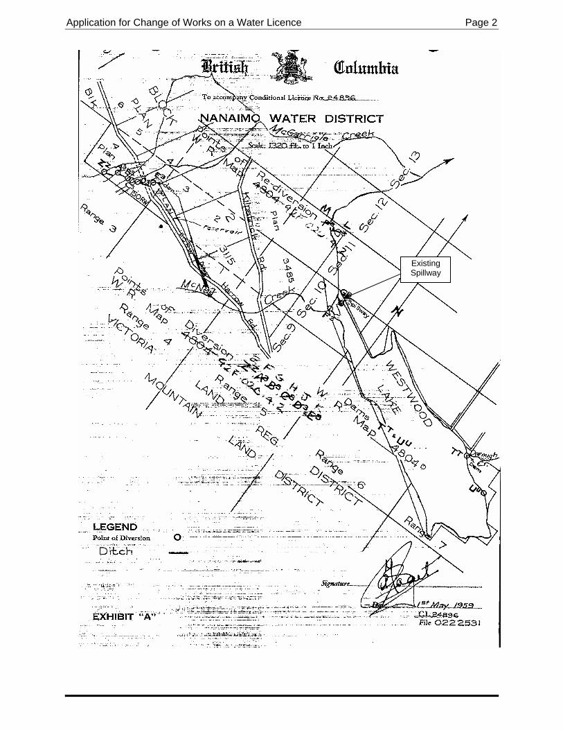
Existing Spillway
powleyr
Preliminary

ATTACHMENT 2

ATTACHMENT 3
July 13, 2009
BRITISH COLUMBIA
The Best Place on Earth
File: 76915-20/D720003-01-Westwood Lake Dam
Bill Sims Manager, Water Resources City ofNanaimo Dept. of Engineering and Public Works 2020 Labieux Rd Nanaimo BC V9T 6J9
Dear Bill:
Re: Audit of Westwood Lake Dam - June 16,2009
Dam Safety Audits are undertaken by Dam Safety Officers every 5 years for high and very high consequence dams. The purpose of the Dam Safety Audit is to determine the dam owner's compliance with the Dam Safety Regulation; it is not intended to be an inspection of the dam. Annual dam inspections and weekly site surveillance are the responsibility of the dam owner.
On June 16, 2009 I undertook dam safety audits of the We~twood Lake Dam and spillway with John Baldwin from our Nanaimo office, yourself, Richie Fulla and Scott Pamminger. A copy of the Dam Audit Check Sheet is attached. The purpose of a dam safety audit is to verify that your dams are in compliance with ten dam safety regulation requirements, listed on the Dam Audit Check Sheet. All of the ten regulation requirements have been met for this dam.
Along with the regulatory requirements, the dam safety audit is also undertaken to verify that the consequence rating, structural attributes, maintenance and reservoir operation are appropriate for the safety of the dam. Below is a list of improvements, concerns or issues that were discussed during the audit with recommendations for remedial action or improvement as required. You may wish to bring these issues/concerns to the attention of your engineering consultant and include any improvements or remediation work in your dam safety management plan.
. . .12
Ministry of Dam Safety Section Mailing Address: Location: Environment Management and Standards Branch PO Box 9340 Stn Prav GoY! 3rd Floor, 395 Waterfront eres
Water Stewardship Division Victoria Be V8W 9M1 Victoria Be V8T 51<7 Telephone: 250-387-3263 Facsimile: 250-952-6792 0
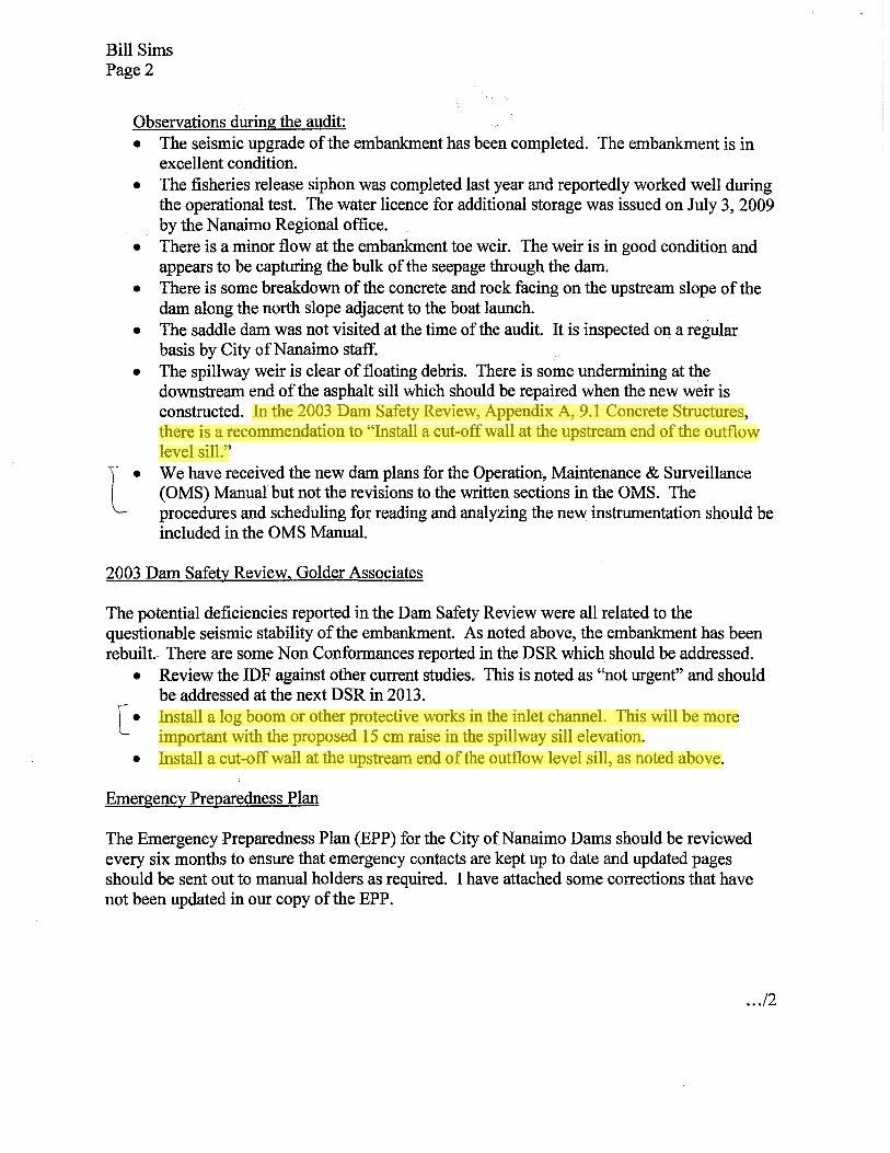
Bill Sims Page 2
Observations during the audit: • The seismic upgrade of the embankment has been completed. The embankment is in
excellent condition. • The fisheries release siphon was completed last year and reportedly worked well during
the operational test. The water licence for additional storage was issued on July 3,2009 by the Nanaimo Regional office.
• There is a minor flow at the embankment toe weir. The weir is in good condition and appears to be capturing the bulk of the seepage through the dam.
• There is some breakdown of the concrete and rock facing on the upstream slope of the dam along the north slope adjacent to the boat launch.
• The saddle dam was not visited at the time of the audit. It is inspected on a regular basis by City ofNanaimo staff.
• The spillway weir is clear of floating debris. There is some undermining at the downstream end of the asphalt sill which should be repaired when the new weir is constructed. In the 2003 Dam Safety Review, Appendix A, 9.1 Concrete Structures, there is a recommendation to "Install a cut-off wall at the upstream end of the outflow level sill."
l . We have received the new dam plans for the Operation, Maintenance & Surveillance (OMS) Manual but not the revisions to the written sections in the OMS. The procedures and scheduling for reading and analyzing the new instrumentation should be included in the OMS Manual.
2003 Dam Safety Review, Golder Associates
The potential deficiencies reported in the Dam Safety Review were all related to the questionable seismic stability of the embankment. As noted above, the embankment has been rebuilt. There are some Non Conformances reported in the DSR which should be addressed.
• Review the IDF against other current studies. This is noted as "not urgent" and should be addressed at the next DSR in 2013.
[. Install a log boom or other protective works in the inlet channel. This will be more important with the proposed 15 cm raise in the spillway sill elevation.
• Install a cut-off wall at the upstream end of the outflow level sill, as noted above.
Emergency Preparedness Plan
The Emergency Preparedness Plan (EPP) for the City ofNanaimo Dams should be reviewed every six months to ensure that emergency contacts are kept up to date and updated pages should be sent out to manual holders as required. I have attached some corrections that have not been updated in our copy of the EPP.
...12
powleyr
Highlight
powleyr
Highlight
powleyr
Highlight
Bill Sims Page 3
Dam owners in British Columbia have a duty to minimize the risk to the public, the economy and the environment by ensuring that the structural integrity, safe operation and adequate maintenance and inspection of dams is adhered to as outlined in the Dam Safety Regulation. I would like to commend you and your staff for doing an excellent job of inspecting and maintaining the Westwood Lake Dam.
Yours truly,
Will Jolley, AScT Dam Safety Section Head
Attachments
pc: John Baldwin, Dam Safety Officer, Water Stewardship Division, Nanaimo

ATTACHMENT 4
Powley, Richard
From: Jolley, William ENV:EX [[email protected]]
Sent: August 17, 2009 4:25 PM
To: Powley, Richard
Cc: Scott Pamminger; Brazier, Bert ENV:EX; Baldwin, John ENV:EX; Barr, Larry ENV:EX; Bill Sims
Subject: RE: Weir Authorization conditions - Westwood Lake
27/08/2009
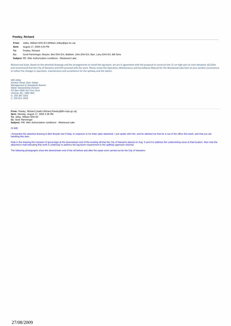
Richard and Scott, Based on the attached drawings and the arrangements to install the log boom, we are in agreement with the proposal to construct the 15 cm high weir at crest elevation 162.83m and recommend that the City of Nanaimo and DFO proceed with the work. Please revise the Operation, Maintenance and Surveillance Manual for the Westwood Lake Dam at your earliest convenience to reflect the changes in operation, maintenance and surveillance for the spillway and the siphon. Will Jolley Section Head, Dam Safety Management & Standards Branch Water Stewardship Division PO Box 9340 Stn Prov Govt Victoria, BC, V8W 9M1 O. 250 387 3263 C. 250 812 1603
From: Powley, Richard [mailto:[email protected]] Sent: Monday, August 17, 2009 3:36 PM To: Jolley, William ENV:EX Cc: Scott Pamminger Subject: FW: Weir Authorization conditions - Westwood Lake Hi Will: I forwarded the attached drawing to Bert Brazier last Friday, in response to his letter (also attached). I just spoke with him, and he advised me that he is out of the office this week, and that you are handling this dam. Note in the drawing the inclusion of grout bags at the downstream end of the existing sill that the City of Nanaimo placed on Aug. 5 and 6 to address the undermining issue at that location. Also note the attached e-mail indicating that work is underway to address the log-boom requirement in the spillway approach channel. The following photographs show the downstream end of the sill before and after the repair work carried out be the City of Nanaimo:
27/08/2009
Could you please advise at your earliest convenience whether or not we can proceed with installation of the weir? Thanks.
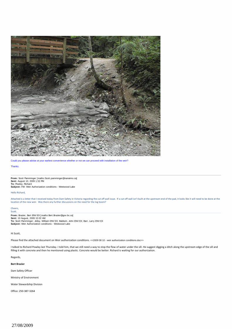
From: Scott Pamminger [mailto:[email protected]] Sent: August 10, 2009 1:52 PM To: Powley, Richard Subject: FW: Weir Authorization conditions - Westwood Lake
Hello Richard, Attached is a letter that I received today from Dam Safety in Victoria regarding the cut off wall issue. If a cut‐off wall isn’t built at the upstream end of the pad, it looks like it will need to be done at the location of the new weir. Was there any further discussions on the need for the log boom? Cheers, Scott.
From: Brazier, Bert ENV:EX [mailto:[email protected]] Sent: 10 August, 2009 10:02 AM To: Scott Pamminger; Jolley, William ENV:EX; Baldwin, John ENV:EX; Barr, Larry ENV:EX Subject: Weir Authorization conditions - Westwood Lake
Hi Scott,
Please find the attached document on Weir authorization conditions. <<2009 08 10 - weir authorization conditions.doc>>
I talked to Richard Powley last Thursday. I told him, that we still need a way to stop the flow of water under the sill. He suggest digging a ditch along the upstream edge of the sill and filling it with concrete and then he mentioned using plastic. Concrete would be better. Richard is waiting for our authorization.
Regards,
Bert Brazier
Dam Safety Officer
Ministry of Environment
Water Stewardship Division
Office: 250‐387‐3264
27/08/2009