Cheakamus River October 2003 Flood Restoration...
18
NVOS Hatchery in flood October 2003 Cheakamus River October 2003 Flood Restoration Project (04.Ch.03) Government of Canada Fisheries and Oceans Canada North Vancouver Outdoor School
Transcript of Cheakamus River October 2003 Flood Restoration...
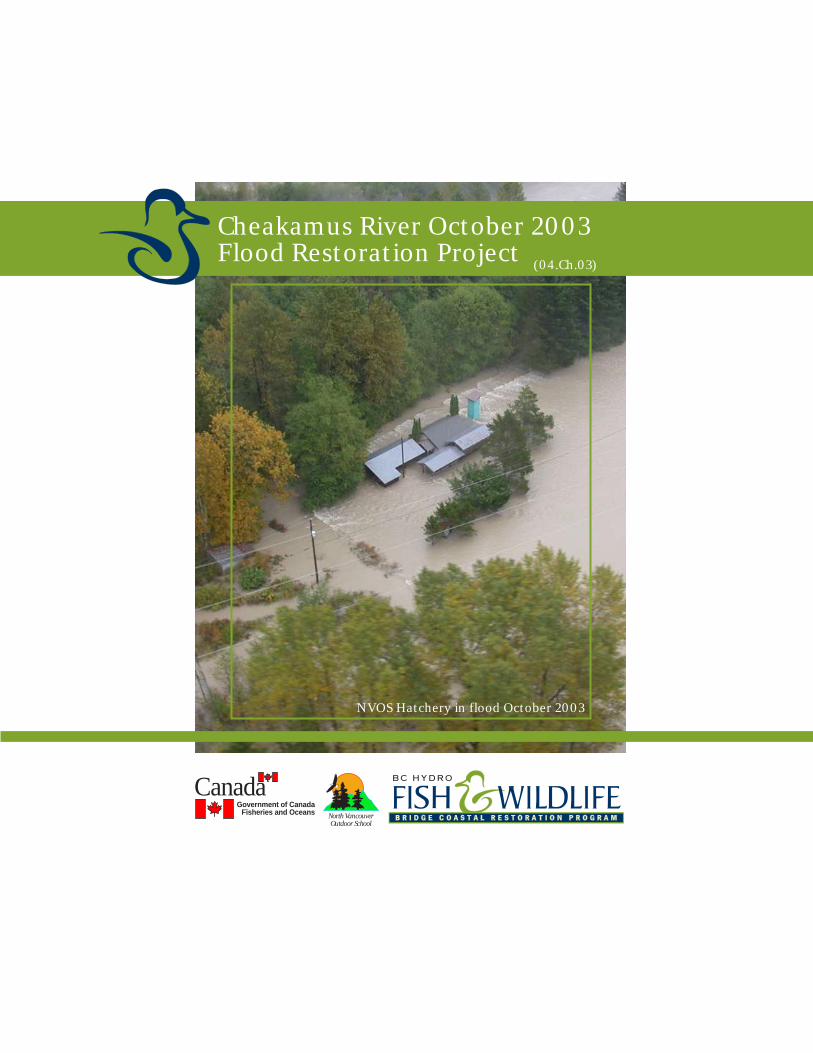
NVOS Hatchery in flood October 2003
Cheakamus River October 2003Flood Restoration Project (04.Ch.03)
Government of CanadaFisheries and Oceans
CanadaNorth VancouverOutdoor School
Cheakamus River October 2003Flood Restoration
Final Report
Submitted by: NorthVancouver Outdoor SchoolSchool District #44
Prepared by: Carl Halvorsonwith financial support of the
BC Hydro Bridge Coastal Fish and Wildlife Restoration Program
Table of Contents
Executive Summary
1. Introduction
2. Study Area
3. Methods
4. Results
5. Acknowledgements
Appendices
A. Financial Statements
B. Restoration Details (maps / photos / drawings)1. Site Location Map2. NVOS Site Map3. Photo Pages 1 - 54. Far Point intake site map5. Bighouse channel layout6. Eagle Point Connector channel layout
C. Additional Information
Executive Summary
This project involved restoration and reconstruction of channel habitats and support structures forsalmonid habitat located at North Vancouver Outdoor School (NVOS) that were impacted by theOctober 2003 flood of record on the Cheakamus River.
Several sites on property were damaged. Works included required upgrades to the dike at the Far Pointintake, repair of the dike and valve intake at the Gorbuscha intake valve (previous BCRP project 02.Ch.6),reconstruction of a protective berm washed away on Moodie’s Channel, restoration of two sections ofMoodie’s Channel, replacement of LWDs in the Moodie’s Sidechannel pond complex, replacement ofLWDs in the Canoe Pond and “Hydro Pond”. Other restoration works after the 2003 flood includedthe reconstruction of Kisutch Channel and restoration of the protective berm that prevent flood flowsthat outflank NVOS dikes to flow down through the NVOS hatchery and downstream spawningchannels and replacement of a roadbridge crossing Lower Paradise Channel.
This project involved restoration of 350 meters of sidechannel, repairing 2800 square meters (m2) ofhabitat and 1600 m2 of new habitat. More than 130 pieces of “Large Woody Debris” (LWDs) androotwads were replaced in various pond complexes.
This project was link to other ongoing initiatives funded by various partnership groups including theSchool Protection Program, the Provincial Emergency Program, District of Squamish, School District#44 and the concurrent BCRP project 04.Ch.1 (Mykiss Channel Construction).
Introduction
The North Vancouver Outdoor School (NVOS) has worked with the Department of Fisheries andOceans Canada (DFO) and various funding partners to develop salmon habitat restoration projects onschool property over the last two decades. These projects have been directed at improving spawningand rearing habitats for coho, chum, chinook and pink salmon. NVOS has operated a teaching hatcherythat has produced chum, chinook and coho fry for over two decades.
This project was directed at restoring important spawning and rearing habitats and support structuresdamaged in the October 2003 flood of record.
Study Area
The restoration sites are located off the west bank of the Cheakamus River on property owned by theNorth Vancouver Outdoor School, School District 44 (North Vancouver).
Map reference is Natural Resources Canada NTS map Cheakamus 92G/14.between (Far Point intake structure): N 49°˚ 49. 844' W123°˚ 09. 396'
and (the Moodie’s Channel exit): N 49˚° 48. 687' W123°˚ 08. 983'
Methods
Materials excavated during the linked BCRP project 04.Ch.1 were utilized to restore and upgradeprotective dike and berm infrastructures. Approx. 2080 m3 of rock was excavated from the Farpointintake site and placed on the reconstructed dike nearby. Appox, 2200 m3 of engineered fill supplied bythe District of Squamish was placed and compacted during reconstruction of this dike. (This materialsupplied by the District of Squamish replaced aluvial gravels borrowed from NVOS to make emergencyrepairs to Paradise Valley Road - immediately following the October 2003 flood)
Approx. 50 m3 of excavated fill was used to fill and repair flood damage at the Gorbuscha intake valvesite.
Approx. 100 m3 of excavated rock was transported to repair the Gorbuscha Intake site.
Approx. 1275 m3 of excavated fill was transported to the Moodie’s Channel protective berm. Thismaterial was placed and compacted with funding from the Provincial Emergency Program.
Approx. 500 m3 of excavate fill was transported, placed and compacted to repair the protective bermjust north of the NVOS hatchery.
Excavation was done with Cat 225, 235 and 320 excavators and Cat 966 loaders. Material was movedaround site by a variety of standard dump trucks and a D250 Cat truck.
LWDs were replaced using a Cat 320 excavator for placement and transported with standard dumptrucks and a D250 Cat truck. LWDs were supplied by NVOS.
NVOS partnered with Fisheries and Oceans Canada during all phases of the design and developmentof these restoration works.
Results
Repair work after the 2003 flood has resulted in restoration of a total of almost 2800 square metres(m2) of enhanced off channel spawning and rearing habitat for pink, chinook, coho, and chum salmonand steelhead trout.
Reconstruction work at the NVOS Bighouse / Canoe Pond outfall has resulted in the creation of 90m of new side channel habitat totalling approx. 400 m2 in area. Approx. 70+ LWDs were replaced invarious habitats.
The Farpoint intake dike was upgraded to Ministry standards with the addition of 2000 m3 of rocksupplied during excavation of the new intake outflow channel and pond.
The berm protecting the NVOS hatchery and downstream salmonid habitats was repaired with theaddition of 500 m3 of compacted materials.
Repairs to the Moodie’s Channel re-established approx. 1600 m2 of prime chum spawning habitat.
Reconstruction work of the NVOS Canoe Pond / Eagle Point Intake connector channel has resultedin the re-creation of 200 m of side channel habitat, totalling approx. 1200 m2 in area, that was destroyedor damaged during the October 2003 flood event. Approx. 60+ LWDs were placed during this phaseof construction, creating several refuge areas and “log jamb” features.
5: Acknowledgements
This project would not have been possible without the financial support of BC Hydro Bridge CoastalFish and Wildlife Restoration Program and the technical and supervisory support of Fisheries andOceans Canada Pacific Region Habitat and Enhancement Branch, particularly Matt Foy, HaroldBeardmore, and Sam Gidora.
Excavation contraction was provided by John Hunter Ltd.
Engineered gravel for dike reconstruction was supplied by the District of Squamish (replacing materialsborrowed from North Vancouver Outdoor School to make emergency road repairs following theOctober 2003 flood event).
Additional funding to complete repairs detailed in this report were supplied by the School ProtectionPlan, the Provincial Emergency Program and School District #44.
Rock, additional gravels and LWDs were supplied on site by North Vancouver Outdoor School.
Letters of support were furnished for the initial funding application by:Randall Lewis Squamish Nation; Harold Beardmore P.Eng. Fisheries and Oceans; Edith Tobe, for theSquamish River Watershed; Steve Rochetta BC WLAP Habitat Officer for Squamish; Jesse Neri, forDFO confirming contribution; Diane Schartner, for the Pacific Foundation for Understanding Nature.
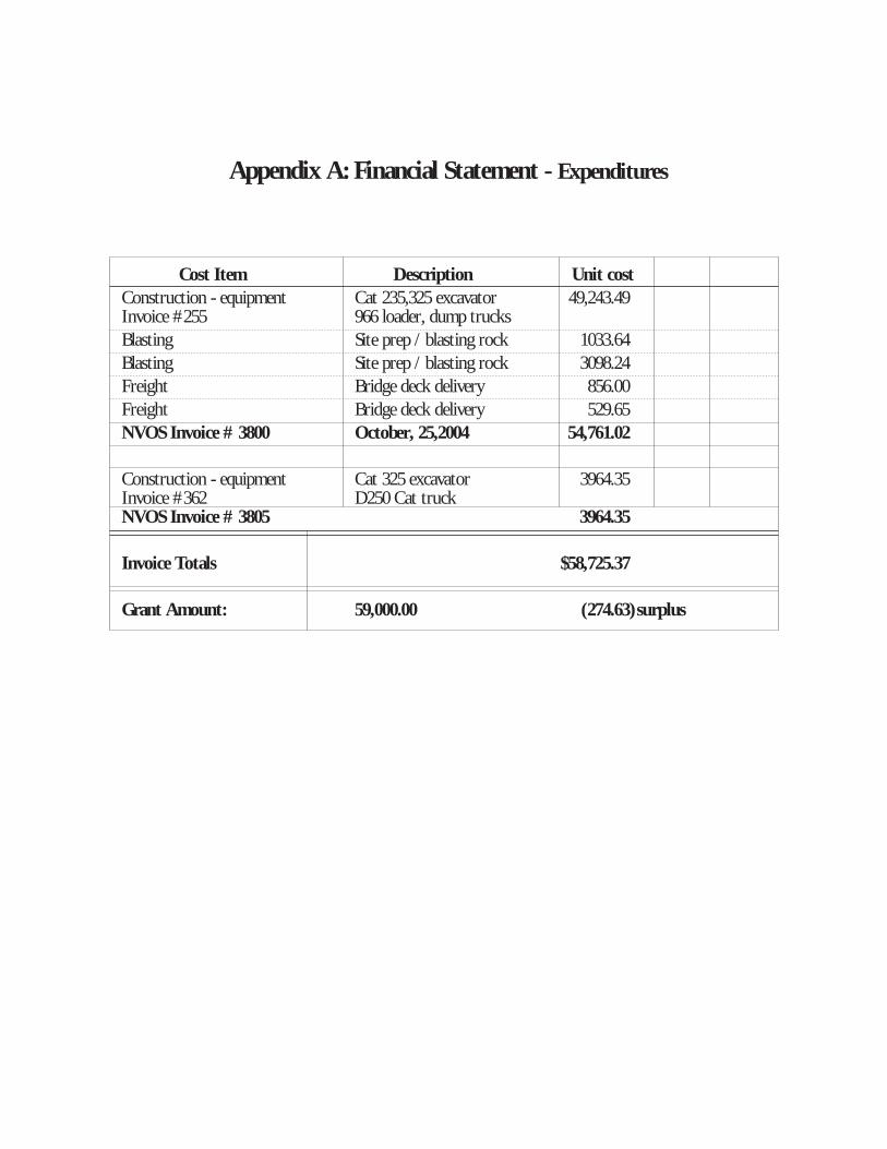
Appendix A: Financial Statement - Expenditures
Cost Item Description Unit cost
Construction - equipment Cat 235,325 excavator 49,243.49Invoice #255 966 loader, dump trucks
Blasting Site prep / blasting rock 1033.64
Blasting Site prep / blasting rock 3098.24
Freight Bridge deck delivery 856.00
Freight Bridge deck delivery 529.65
NVOS Invoice # 3800 October, 25,2004 54,761.02
Construction - equipment Cat 325 excavator 3964.35Invoice #362 D250 Cat truckNVOS Invoice # 3805 3964.35
Invoice Totals $58,725.37
Grant Amount: 59,000.00 (274.63) surplus
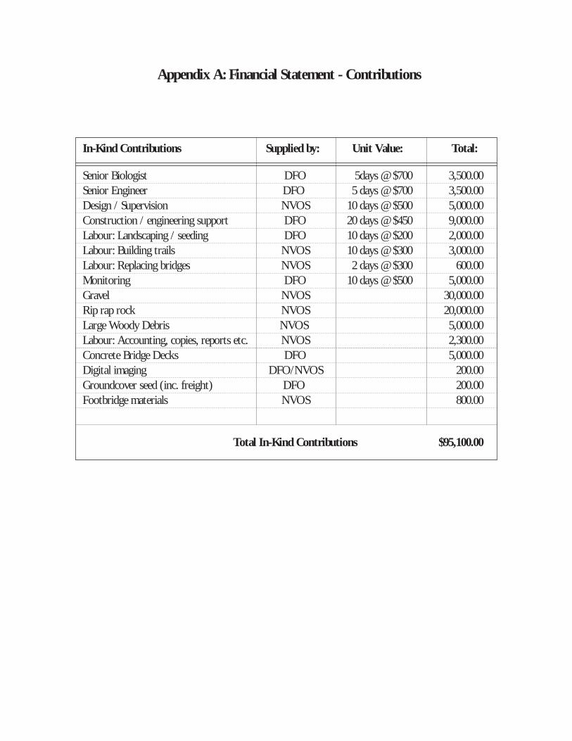
Appendix A: Financial Statement - Contributions
In-Kind Contributions Supplied by: Unit Value: Total:
Senior Biologist DFO 5days @ $700 3,500.00
Senior Engineer DFO 5 days @ $700 3,500.00
Design / Supervision NVOS 10 days @ $500 5,000.00
Construction / engineering support DFO 20 days @ $450 9,000.00
Labour: Landscaping / seeding DFO 10 days @ $200 2,000.00
Labour: Building trails NVOS 10 days @ $300 3,000.00
Labour: Replacing bridges NVOS 2 days @ $300 600.00
Monitoring DFO 10 days @ $500 5,000.00
Gravel NVOS 30,000.00
Rip rap rock NVOS 20,000.00
Large Woody Debris NVOS 5,000.00
Labour: Accounting, copies, reports etc. NVOS 2,300.00
Concrete Bridge Decks DFO 5,000.00
Digital imaging DFO/NVOS 200.00
Groundcover seed (inc. freight) DFO 200.00
Footbridge materials NVOS 800.00
Total In-Kind Contributions $95,100.00
Appendix B: Recognition of
BC Hydro Bridge Coastal Fish and Wildlife Restoration Program
• All publicity activities will be made in the name of the "BC Hydro Bridge Coastal Fish and WildlifeRestoration Program.
• Information regarding the project will be communicated to members of the Squamish River WatershedSociety which include most of the groups in the area that are interested in fish and wildlife issues.
• The North Vancouver Outdoor School produces a school newsletter, which goes out to a wide audienceof staff, students, alumni and partners. This project has been included in that newsletter.
Appendix C: Construction Details / Images
(see attached files)
• Site location map• NVOS site plan• Photo pages (5)• Far Point intake site plan• Bighouse Channel reconstruction site plan• Eagle Point Connector Channel site plan
Appendix D: Additional Information
• Far Point dike approval letter from Diking Authority
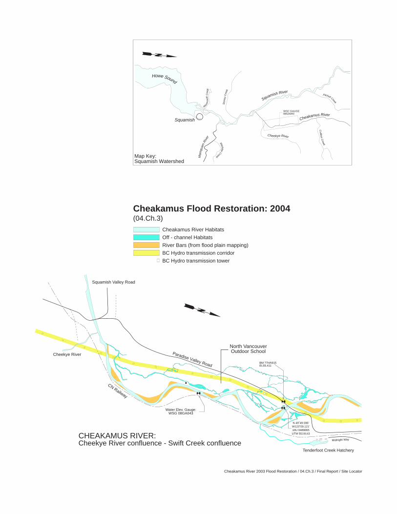
Cheakamus River 2003 Flood Restoration / 04.Ch.3 / Final Report / Site Locator
WSC GAUGE08GA043
Squamish
Howe Sound
M
onm
outh
Cre
ek
Sto
ney
Cre
ek
Mam
quam
Riv
er
MashiterC
reek
Cheekye River
Cullito
nC
reek
Pilchuk Creek
Cheakamus River
Squamish River
Map Key:Squamish Watershed
BM 77HA915EL55.411
N 49˚49.596'W123˚09.121'10U 0489065UTM 5519143
Paradise Valley Road
Tenderfoot Creek Hatchery
Midnight Way
Squamish Valley Road
North VancouverOutdoor School
CN Railway
Cheekye River
CHEAKAMUS RIVER:Cheekye River confluence - Swift Creek confluence
Water Elev. Gauge:WSG 08GA043
Cheakamus Flood Restoration: 2004(04.Ch.3)
Cheakamus River Habitats
Off - channel Habitats
River Bars (from flood plain mapping)
BC Hydro transmission corridor
BC Hydro transmission tower
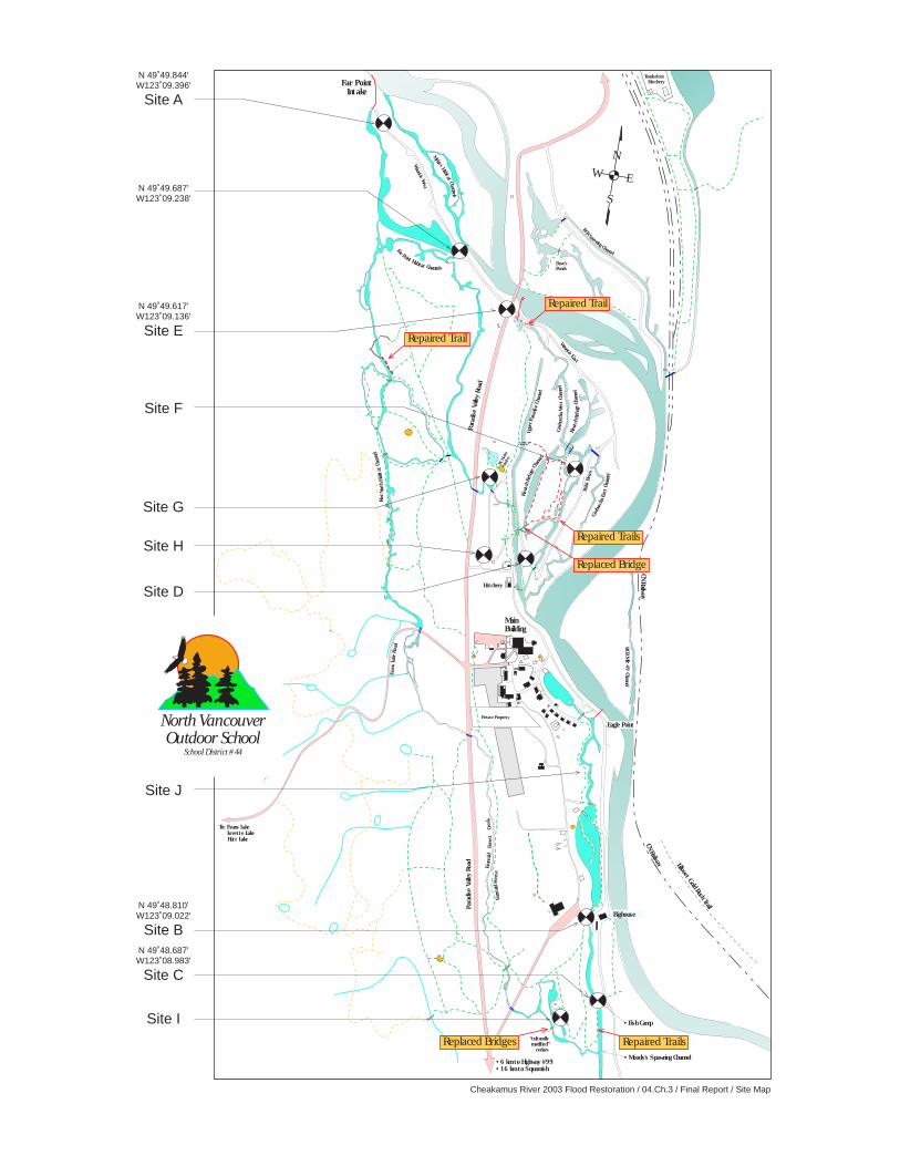
Cheakamus River 2003 Flood Restoration / 04.Ch.3 / Final Report / Site Map
N
S
EW
duck po
nd
Hatchery
• Fish Camp
• Moody's Spawning Channel
Em
erald
Forest
Cre
ek
Main
Building
BC H
ydro
Shelt
er
Wountie E
ast
Upper
Para
dis
eChannel
Kis
utch
Refuge
Channel
Bob's
Berm
Dave's
Ponds
BCR
Spawning
Channel
Kiw
iNort
hHabitat
Channel
Evans
Lake
Road
Em
erald
Forest
“culturally
modified”
cedars
Tenderfoot
Hatchery
Lillooet G
old R
ush Tra
il
chee-Y
AK-m
ush
“fis
hw
eir
pla
ce”
CN
Railw
ay
BCR
Mi l e
49
Channel
• 6 km to Highway #99
• 16 km to Squamish
CN
Rail w
ay
Far Point
Intake
Paradis
eValle
yRoad
Paradis
eVal le
yRoad
Cheak
amus
River
Kis
utch
Refug
eCha
nnel
Gorb
uscha
East
Chann
el
Gorb
uscha
West
Channel
Woun
tie
West
To: Evans Lake
Levette Lake
Hutt Lake
Private Property
Fa
rPoint
Habitat Channels
Mykis
sHabit
at
Chann
el s
Repaired Trail
Repaired Trail
Repaired Trails
Replaced Bridge
N 49˚49.844'W123˚09.396'
Site A
N 49˚49.687'W123˚09.238'
N 49˚49.617'W123˚09.136'
Site E
N 49˚48.810'W123˚09.022'
Site B
Site F
Site D
Site H
Site G
N 49˚48.687'W123˚08.983'
Site C
Site I
North VancouverOutdoor School
School District #44
Bighouse
Replaced Bridges Repaired Trails
Eagle Point
Site J
Cheakamus River 2003 Flood Restoration / 04.Ch.3 / Final Report / Photo page 1
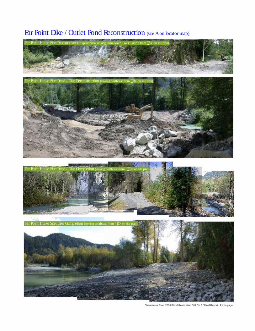
Far Point Dike / Outlet Pond Reconstruction (site A on locator map)
Far Point Intake Site: Dike Completion (looking southeast from D on site plan)
Far Point Intake Site: Preconstruction (panorama looking from south - west - north from A on site plan)
Far Point Intake Site: Pond / Dike Reconstruction (looking northeast from B on site plan)
Far Point Intake Site: Pond / Dike Completion (looking northeast from C on site plan)
Cheakamus River 2003 Flood Restoration / 04.Ch.3 / Final Report / Photo page 2
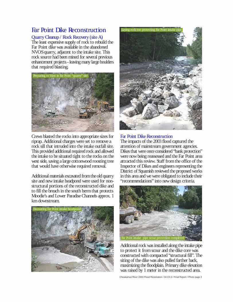
Far Point Dike Reconstruction
Preparing to blast in Far Point “quarry” site
Excavating Far Point intake headpond
Far Point intake pipe scour protection completed
Laying rock toe protecting Far Point intake pipe
Quarry Cleanup / Rock Recovery (site A)The least expensive supply of rock to rebuild theFar Point dike was available in the abandonedNVOS quarry, adjacent to the intake site. Thisrock source had been mined for several previousenhancement projects - leaving many large bouldersthat required blasting.
Crews blasted the rocks into appropriate sizes forriprap. Additional charges were set to remove arock sill that intruded into the intake outfall site.This provided additional required rock and allowedthe intake to be situated tight to the rocks on thewest side, saving a large cottonwood roosting treethat would have otherwise required removal.
Additional materials excavated from the old quarrysite and new intake headpond were used for non-structural portions of the reconstructed dike andto fill the breach in the south berm that protectsMoodie’s and Lower Paradise Channels approx. 1km downstream.
Far Point Dike ReconstructionThe impacts of the 2003 flood captured theattention of mainstream government agencies.Dikes that were once considered “bank protection”were now being reassessed and the Far Point areaattracted this review. Staff from the office of theInspector of Dikes and engineers representing theDistrict of Squamish reviewed the proposed worksin this area and we were obligated to include their“recommendations” into new design criteria.
Additional rock was installed along the intake pipeto protect it from scour and the dike core wasconstructed with compacted “structural fill”. Thesiting of the dike was also pulled farther back,maximizing the floodplain. Primary dike elevationwas raised by 1 meter in the reconstructed area.
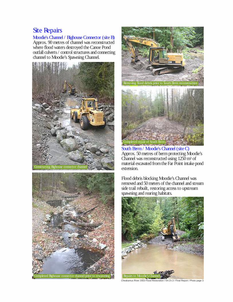
Site Repairs
Cheakamus River 2003 Flood Restoration / 04.Ch.3 / Final Report / Photo page 3
Constructing Bighouse connector channel
Completed Bighouse connector channel prior to rewatering Repairs to Moodie’s Channel
Completed repair of South Berm
Removing flood debris prior to South Berm reconstruction
Moodie's Channel / Bighouse Connector (site B)Approx. 90 metres of channel was reconstructedwhere flood waters destroyed the Canoe Pondoutfall culverts / control structures and connectingchannel to Moodie’s Spawning Channel.
South Berm / Moodie's Channel (site C)Approx. 50 metres of berm protecting Moodie’sChannel was reconstructed using 1250 m3 ofmaterial excavated from the Far Point intake pondextension.
Flood debris blocking Moodie’s Channel wasremoved and 50 meters of the channel and streamside trail rebuilt, restoring access to upstreamspawning and rearing habitats.
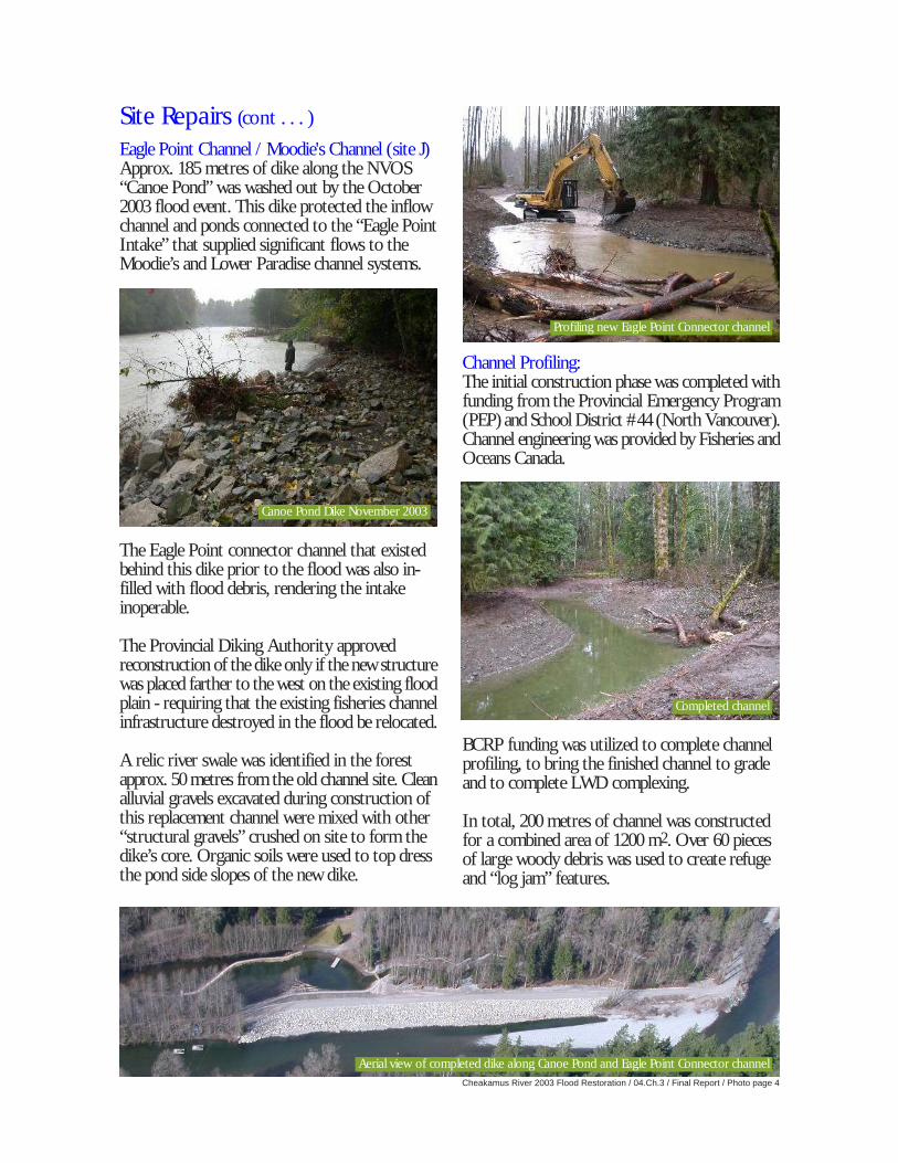
Cheakamus River 2003 Flood Restoration / 04.Ch.3 / Final Report / Photo page 4
Site Repairs (cont . . . )
Eagle Point Channel / Moodie's Channel (site J)Approx. 185 metres of dike along the NVOS“Canoe Pond” was washed out by the October2003 flood event. This dike protected the inflowchannel and ponds connected to the “Eagle PointIntake” that supplied significant flows to theMoodie’s and Lower Paradise channel systems.
The Eagle Point connector channel that existedbehind this dike prior to the flood was also in-filled with flood debris, rendering the intakeinoperable.
The Provincial Diking Authority approvedreconstruction of the dike only if the new structurewas placed farther to the west on the existing floodplain - requiring that the existing fisheries channelinfrastructure destroyed in the flood be relocated.
A relic river swale was identified in the forestapprox. 50 metres from the old channel site. Cleanalluvial gravels excavated during construction ofthis replacement channel were mixed with other“structural gravels” crushed on site to form thedike’s core. Organic soils were used to top dressthe pond side slopes of the new dike.
Channel Profiling:The initial construction phase was completed withfunding from the Provincial Emergency Program(PEP) and School District #44 (North Vancouver).Channel engineering was provided by Fisheries andOceans Canada.
BCRP funding was utilized to complete channelprofiling, to bring the finished channel to gradeand to complete LWD complexing.
In total, 200 metres of channel was constructedfor a combined area of 1200 m2. Over 60 piecesof large woody debris was used to create refugeand “log jam” features.
Canoe Pond Dike November 2003
Profiling new Eagle Point Connector channel
Completed channel
Aerial view of completed dike along Canoe Pond and Eagle Point Connector channel
Site Repairs (cont . . . )
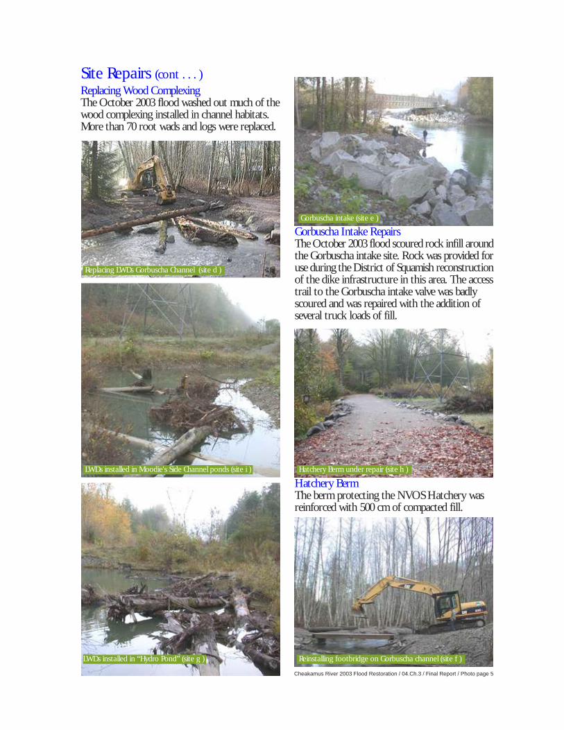
Cheakamus River 2003 Flood Restoration / 04.Ch.3 / Final Report / Photo page 5
Replacing LWDs Gorbuscha Channel (site d )
Gorbuscha intake (site e )
LWDs installed in Moodie's Side Channel ponds (site i ) Hatchery Berm under repair (site h )
LWDs installed in “Hydro Pond” (site g ) Reinstalling footbridge on Gorbuscha channel (site f )
Replacing Wood ComplexingThe October 2003 flood washed out much of thewood complexing installed in channel habitats.More than 70 root wads and logs were replaced.
Gorbuscha Intake RepairsThe October 2003 flood scoured rock infill aroundthe Gorbuscha intake site. Rock was provided foruse during the District of Squamish reconstructionof the dike infrastructure in this area. The accesstrail to the Gorbuscha intake valve was badlyscoured and was repaired with the addition ofseveral truck loads of fill.
Hatchery BermThe berm protecting the NVOS Hatchery wasreinforced with 500 cm of compacted fill.
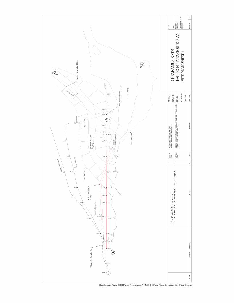
Cheakamus River 2003 Flood Restoration / 04.Ch.3 / Final Report / Intake Site Final Sketch
Exis
ting F
ar P
oin
t In
take
•
• cr
est
of
new
dik
e 2
004
Pho
to R
efer
ence
Arr
ows
Che
aka
04.C
h.1
/ Fin
al R
epor
t / P
hoto
pag
e 1
• top o
f old d
ike cr
est
• lo
cati
on o
f o
ld c
oncr
ete
bo
x
new
inta
ke p
ipe •
(2004)
• head
wal
l•
3' v
alve
ass
em
bly
new
po
nd (2004)
• dik
e r
eal
ignm
ent
2004
• 5 m
cre
st•
61.0
m e
leva
tio
n +
/-
line o
f ro
ck t
oe •
SCA
LE:
DA
TE:
May
2004
SEPT
2004
DRA
WIN
G N
UM
BER
:CH
-04-0
3
CH
EA
KA
MU
S R
IVER
FAR
PO
INT
IN
TA
KE S
ITE P
LAN
SIT
E P
LAN
SH
EET
1
DES
IGN
ED
DRA
WN
: CH
CH
ECK
ED
APP
RO
VED
REC
OM
MEN
DED
1M
AY
21
2004
SITE
SKET
CH
- (PR
ECO
NST
RU
CTIO
N)
ALL
DIM
ENSI
ON
S REP
RES
ENTA
TIV
E.
2REV
ISIO
NA
PPRO
VED
REV
ISIO
ND
ATE:
NO
.N
OTES
REF
EREN
CE
DRA
WIN
GS
DW
G.N
O.
• 15 m
• 9 m
• 4 m
• 19 m
• 21 m
• 24 m
• 25 m
• 7 m
• 6 m
• 5.5 m
• 4 m
• 3 m
• 6 m 0+00 •
0-10 •
0-20 •
• 0+10
• 0+15
• 0+20
0+30 •
• 0+40
• 0+50
• 0+60
• 0+67
• 0+54
• 0+70
0+80 •
• nai
l - U
nderh
ill a
nd U
nderh
illm
onum
ent
#296 -
2004 (dest
roye
d)
336˚ºo
mag
neti
c
larg
eco
tto
nw
oo
d
larg
eco
tto
nw
oo
ds
C
• 3 m
larg
e r
ock
• 0-36
0-30 •
17.5
m18.5
m
bas
e o
f m
ounta
in •
• ed
ge
of
clea
ring
• ed
ge
of
rive
r / ch
annel
2SE
PT 2
92004
SKET
CH
- A
S BU
ILT N
EW D
OW
NST
REA
M IN
TA
KE
PIPE
/ V
ALV
E /
PON
DA
LL D
IMEN
SIO
NS
REP
RES
ENTA
TIV
E.
B
C
A
D

Cheakamus River 2003 Flood Restoration / 04.Ch.3 / Final Report / Bighouse Site Final Sketch
North VancouverOutdoor School
School District #44
Government of CanadaFisheries and Oceans
Canada
Cheakamus October 2003
Flood Damage Restoration
BCRP project: 04.Ch.03
chalvorson. 9.4.2004
scale: one unit = 10 m
Moodie's Channel: Site B
Bighouse Repair
Reach Specifications:
90 metres in length
400 m2 channel total
200 m2 "refuge" pockets
9 LWDs
Average reach gradient - riffle/pool drops
N
S
E W
Skw'une-was
Bighouse
Skw
'une-w
as
Activ
ity S
hed
Cook
Shelter
SmokeHouse
BCR Railcar Bridge
20.0
0.0
10.0
30.0
40.0
50.0
60.0
70.0
80.0
90.0
flow
Moodie
's/L
ow
er P
aradis
espaw
nin
g c
hannels
NVOS Canoe Pond
control weir
control weir
control
weir
control
weir
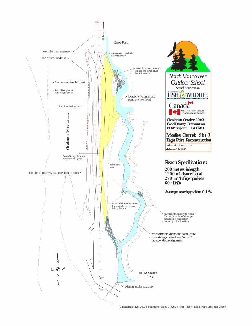
Cheakamus River 2003 Flood Restoration / 04.Ch.3 / Final Report / Eagle Point Site Final Sketch
North VancouverOutdoor School
School District #44
Government of CanadaFisheries and Oceans
Canada
Cheakamus October 2003
Flood Damage Restoration
BCRP project: 04.Ch.03
chalvorson. 3.14.2005
scale: one unit = 10 m
Moodie's Channel: Site J
Eagle Point Reconstruction
Reach Specifications:
200 metres in length
1200 m2 channel total
270 m2 "refuge" pockets
60+ LWDs
Average reach gradient 0.1%
N
S
E W
location of roadway and dike prior to flood •
Cheak
amus
Riv
er
(flo
w)
• location of channel andpond prior to flood
Water Survey of Canada“Brackendale” gauge
• line of floodplain atrailway right of way
line of washed out toe •
• wood debris used to createlog jam and other refugehabitat features
• existing intake structure
• new trail infrastructure to replace“Fuzzy’s Forest Foray” destroyedduring dike reconstruction
• funded by public donations
• new salmonid channel infrastructure• pre-existing channel was “under”
the new dike realignment
new dike crest alignment •
line of new rock toe •
• Cheakamus River left bank
Canoe Pondto B
igho
use
to NVOS cabins
• reconstructed pond sidetrail to Bighouse
• wood debris used to createlog jam and other refugehabitat features
40
50
30
20
10
0
top
of b
ank
80
70
60
0+50
140
130
120
110
100
90
150
160
170
180
190
200
210
220
230
240
250
0+150
0+130
cottonwoodoff roadway
0+0
0-5
0+160
0+170
telephonepole
0+180
0+190
0+200
“RST”anchorpoint
0+210
0+220
0+230
0+240
0+250
0+260
0+270
0+280
0+290
0+295
0+300
0+310
0+320
0+340
0+330
end of works
0+50
0+60
0+70
0+80
0+90
0+10
0+20
0+30
0+40
0+100
0+110
0+120
0+140
cottonwoodoff roadway